20160111-BombRisk Report Setup-v0.2-EH sw
12
BombRisk.com www.bombrisk.com Preliminary Unexploded Ordnance Risk Assessment Project: 19 THE LINDENS, NEW ADDINGTON, CROYDON CR0 9EG Prepared for: London Borough of Croydon Client ref: 19 - 21 The Lindens Report prepared by Dynasafe BACTEC Limited and FIND Mapping Limited Report reference: 500592 SAFE RELIABLE PROFESSIONAL The established market leader in UXO RISK MITIGATION
Transcript of 20160111-BombRisk Report Setup-v0.2-EH sw

BombRisk.com
www.bombrisk.com
Preliminary Unexploded Ordnance Risk Assessment
Project: 19 THE LINDENS, NEW ADDINGTON, CROYDON CR0 9EG Prepared for: London Borough of CroydonClient ref: 19 - 21 The LindensReport prepared by Dynasafe BACTEC Limited and FIND Mapping Limited Report reference: 500592
SAFE RELIABLE
PROFESSIONAL
The established market leader in
UXO RISK MITIGATION

Preliminary Unexploded Ordnance Threat Assessment
Dynasafe BACTEC Limited and FIND Mapping Limited 1 Report reference: 200273
19 The Lindens, New Addington, Croydon CRO 9EG
Contents Page
1 Executive Summary 02
2 Introduction 03
3 Methodology 05
4 Search Results – Dynasafe BACTEC Limited’s UXO source database 06
5 Risk of UXO based on WWII German bombing density 08
6 Risk of UXO based on WWII German bomb strikes 09
7 Conclusions 10
This document was written by, belongs to and is copyright to Dynasafe BACTEC Limited. It contains valuable Dynasafe BACTEC Limited proprietary and confidential information which is disclosed only for the purposes of the client’s assessment and evaluation of the project which is the subject of this report. The contents of this document shall not, in whole or in part (i) be
used for any other purposes except such assessment and evaluation of the project; (ii) be relied upon in any way by the person other than the client (iii) be disclosed to any member of the client’s organisation who is not required to know such information nor to any third party individual, organisation or government, or (iv) be copied or stored in any retrieval system nor otherwise be reproduced or transmitted in any form by photocopying or any optical, electronic, mechanical or other means, without prior
written consent of the Managing dDirector, Dynasafe BACTEC Limited, 9 Waterside Court, Galleon Boulevard, Crossways Business Park, Dartford, Kent, DA2 6NX to whom all requests should be sent. Accordingly, no responsibility or liability is accepted by Dynasafe BACTEC Limited towards any other person in respect of the use of this document or reliance on the information contained within it, except as may be designated by law for any matter outside the scope of this document.

Dynasafe BACTEC Limited and FIND Mapping Limited 2 Report reference: 200273
1 Executive Summary
1.1 Has a potential UXO Risk been identified at the site in question?
YES
Indicative British / Allied UXO risk MEDIUM
Indicative German UXO risk MEDIUM-HIGH
1.2 Does the site in question require further research to clarify the UXO risk to future ground works?
YES
1.3 Dynasafe BACTEC Limited’s recommendation:
A Stage 2 Detailed Unexploded Ordnance Desktop Threat Assessment of the site is carried out.
To request a quotation please call Dynasafe BACTEC Limited: 01322 284 550
If you order the recommended Stage 2 Detailed Desktop Threat Assessment, you will be refunded the fee for this BombRisk Preliminary Threat Assessment.

Dynasafe BACTEC Limited and FIND Mapping Limited 3 Report reference: 200273
2 Introduction
2.1 Background
Since 1991, Dynasafe BACTEC Limited has supported the UK construction industry by assessing the risk of encountering items of unexploded ordnance (UXO) during intrusive works. Dynasafe BACTEC’s specialist advice provides essential information for threat assessments, improving safety and enhancing reputations, helping contractors avoid costly delays.
Dynasafe BACTEC holds the following accreditations: Occupational Health & Safety Management Systems (OHAS 18001:2007), Environmental Management Systems (ISO 14001:2004) and Quality Management Systems (ISO 9001:2008).
The risk of encountering UXO on most sites in the UK is low. However, where a site is at increased risk it is necessary to take measures to mitigate that risk. The factors affecting UXO threat assessment are based upon the history and previous usage of a site and its surroundings.
In 2009, the Construction Industry Research and Information Association (CIRIA) established a set of guidelines to assist industry professionals.
CIRIA recommends a four stage risk management process:
• Preliminary Threat Assessment
• Detailed Threat Assessment
• Risk Mitigation
• Implementation
The preliminary threat assessment enables a non-UXO specialist to place a site in context and to identify whether a more detailed assessment is necessary. The assessment is based upon data obtained from desktop reviews of the site’s history and its proximity to potential indicators of UXO contamination.
There are two principal groups of onshore UXO in the UK:
• Historical British and / or Allied Army, Navy and Air-Force – domestic military activity
• Enemy action during WWI and WWII – aerial bombing and naval bombardment
These two groups comprise many potential UXO risk contributing sources within the UK, the most significant of which are listed below. Georeferenced databases containing this information are used by BombRisk.com to identify areas of potentially elevated UXO risk.
• Historic army, navy and air-force facilities
• Explosives / ammunition factories
• Munitions storage depots
• Historic military training areas and firing ranges
• British army explosive ordnance clearance tasks / recces

Dynasafe BACTEC Limited and FIND Mapping Limited 4 Report reference: 200273
2 Introduction continued
• WWII heavy anti-aircraft batteries
• WWII anti-invasion defensive fortifications
• Miscellaneous WWII pipe mined locations
• WWII prisoner of war camps
• WWII German bombing density statistics
• WWII bombing decoy sites
• Press articles regarding UXO finds
• Locations of Dynasafe BACTEC UXO finds
• Locations of Dynasafe BACTEC desktop threat assessments
• Locations of Dynasafe BACTEC on-site support services
Established in 2006, FIND Maps Limited is a pioneering web mapping and spatial data technology company offering online mapping and consultancy services.
www.findmaps.co.uk provides detailed mapping and a wealth of data sets to hundreds of the UK’s top property, environmental and design/build companies.
FIND’s consultancy services provide bespoke internet mapping solutions to a range of businesses enabling them to manage their spatial data more effectively.
While working closely with a wide range of reputable data providers including Ordnance Survey and the Environment Agency, FIND works independently of these organisations. A similar arm’s- length relationship is maintained in terms of software and hardware providers. This enables the team at FIND to offer truly independent advice.

Dynasafe BACTEC Limited and FIND Mapping Limited 5 Report reference: 200273
3 Methodology
3
Dynasafe BACTEC Limited and FIND have compiled a geo-referenced database of potential sources of UXO risk within the UK. From this information a range of risk zones have been defined.
The weighting of these zones is based upon the influence of all relevant factors. A WWII-era RAF airfield, for example, has a far greater zone of influence than a single WWII-era Anti- Aircraft Battery, as it would have covered a larger area, housed a much greater quantity / variety of munitions, seen more domestic troop training activities and would have been a more likely target for enemy bombers.
An online Preliminary Automated UXO Threat Assessment will determine an indicative level of UXO risk relating to a site. Note that these risk levels could be subject to change following the completion of any Detailed Desktop Threat Assessment for the same site.
The assessment will list all factors contributing to this weighting and will also give appropriate recommendations for further action, if considered necessary.

Dynasafe BACTEC Limited and FIND Mapping Limited 6 Report reference: 200273
4 Search Results
4 Dynasafe BACTEC Limited’s UXO Source Database
As a capital city, London was an obvious target for the Luftwaffe. The city was home to the British government, the largest docks system in the UK and numerous historic and cultural monuments.
The night time “carpet bombing” Blitz on London began on 7th September 1940 with concentrated attacks coming to an end in May 1941 as the Luftwaffe was diverted east to prepare for ‘Operation Barbarossa’; the invasion of the Soviet Union. By the end of the war London had become the most heavily bombed city in Britain. Between 1940 and 1945 there were a total of 71 ‘major’ air raids on the city, resulting in an estimated 190,000 bombs dropped; approximately 18,000 tons. This left some 29,000 people dead.
During 1942 and 1943 there were a number of minor intruder raids carried out by small formations of fighter bombers and then between January and May 1944 the Luftwaffe returned to London in mass, for Operation Steinbock, a series of large Blitz style raids.
From mid-1944 the “V-weapon” (for Vengeance) campaign, using unmanned cruise missiles and rockets carrying 1,000kg warheads, represented Hitler’s final attempt to reverse Germany’s imminent defeat. The V1 (Flying Bomb or Doodlebug) and the V2 (Long Range Rocket) were launched from bases in Germany and occupied Europe. Totals of 2,419 V1s and 517 V2s were recorded in the London Civil Defence region.
The map included at the end of this report shows the high explosive bombs recorded falling in the region of the site on the available bomb census mapping for the area. Please note that this information comes from a single source and should not be considered definitive in its accuracy or coverage.
Within 10km of the site the following potential sources of explosive ordnance have been recorded:
Source Number
within 10km
Military Airfield Sites 1
Abandoned Bombs 47
Press Articles regarding UXO Finds 3
WWII Defence Related Positions & Pillboxes 56
Historic Army Camps 8
Prisoner of War Camps 5
Heavy Anti-Aircraft Batteries 24
Army Explosive Ordnance Clearance Tasks/Recess 45
Sites Related to the Manufacture of Explosives and Explosive Ordnance 10
Dynasafe BACTEC Desk-top Threat Assessments 397
Bombing Decoy Sites None recorded
Military Training Areas and Firing Ranges None recorded

Dynasafe BACTEC Limited and FIND Mapping Limited 7 Report reference: 200273
4 Search Results continued
Pipe Mined WWII Airfields None recorded
Miscellaneous WWII Pipe Mined Locations None recorded
Dynasafe BACTEC Unexploded Ordnance Finds None recorded
Dynasafe BACTEC On-Site Support Services None recorded
Of these sources, the following are deemed significant enough to be a risk and therefore warrant further research:
Army Explosive Ordnance Clearance Tasks / Recess
Location Approximate distance
(km) from site
Baseswift Ltd, Hoskins Street, Greenwich 1.1
Transporter Yard, Isle Of Dogs, E14 1.6
The site lies within or close to an area where a military clearance operation has been recorded. A clearance operation can describe anything from the recovery of a single item of ordnance found by a member of the public to large scale tasks involving detailed surveys.
Specific research is recommended in order to ascertain the scale of the clearance operation. This would include the type and quantity of ordnance recovered.
Records of a clearance task may indicate a history of military presence in an area. This history increases the risk that further munitions may be present.
Sites Related to the Manufacture of Explosives and Explosive Ordnance
Facility Name Approximate distance
(km) from site
Brunner Mond and Co Ltd, Crescent Wharf/Venesta Wharf, North 1.9
Woolwich Road, Silvertown, Great War 1915-17, Explosives factory –
Vacuum Oil Co Ltd, Millwall, Great War, oil distillery - mineral jelly 2.2
During both WWI and WWII many factories were established (or existing sites converted) to produce explosives and/or fill ordnance with explosive and chemical constituents. These ranged from small engineering works to large National Filling Factories (WWI) and Royal Ordnance Factories (WWII). The site of the proposed works lies in the vicinity of one of these facilities.
For example, a factory producing casings the associated risk is negligible. However, on sites handling or producing explosive and chemical weapons the risk of soil contamination can be high. Disposal areas (often on site boundaries) can pose considerable risk. The history of the facility should be more fully researched.
Dynasafe BACTEC Limited and FIND Mapping Limited 8 Report reference: 200273
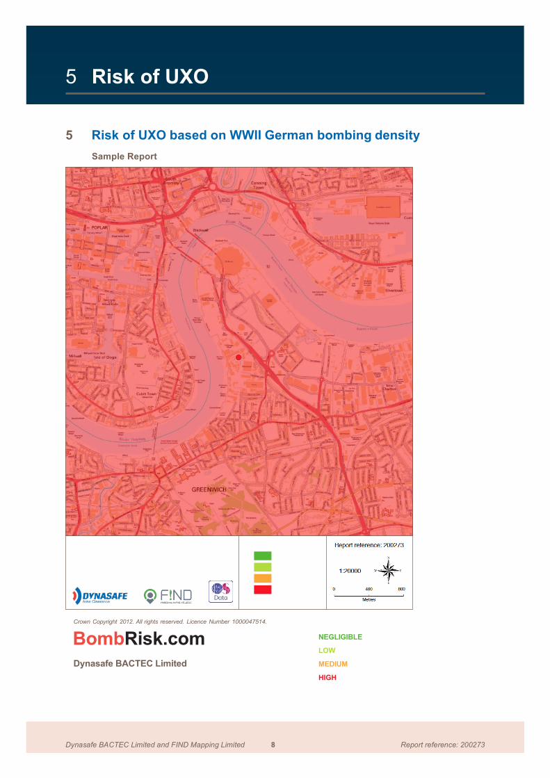
5 Risk of UXO
5 Risk of UXO based on WWII German bombing density
Sample Report
Crown Copyright 2012. All rights reserved. Licence Number 1000047514.
BombRisk.com
Dynasafe BACTEC Limited
NEGLIGIBLE
LOW
MEDIUM
HIGH

Dynasafe BACTEC Limited and FIND Mapping Limited 9 Report reference: 200273
6 Risk of UXO
6 Risk of UXO based on WWII German bomb strikes
Sample Report
Crown Copyright 2012. All rights reserved. Licence Number 1000047514.
BombRisk.com
Dynasafe BACTEC Limited
BOMB STRIKES WITH BUFFER

Dynasafe BACTEC Limited and FIND Mapping Limited 10 Report reference: 200273
7 Conclusions
7 Risk Levels and Recommendation
Indicative British / Allied UXO Risk
MEDIUM
Dynasafe BACTEC’s historical database has identified potential sources of British / Allied UXO within a significant radius of the site. It is recommended that further research is undertaken to determine more about these potential sources, how they may have affected the site and whether or not an elevated UXO risk exists.
Indicative German UXO Risk
MEDIUM – HIGH
Historical records indicate that the borough, within which the site is situated, sustainedan overall medium density of bombing during WWII . Furthermore, a bomb strike(s) was recorded within 50m of the site on the London ARP Bomb Census Maps.
Close proximity to recorded bomb strike(s) indicates a potential risk from UXBs – especially if the site sustained serious damage resulting in rubble and debris.
Conclusion
This Preliminary Assessment has resulted in an overall (indicative) Medium-High risk from UXO at the site in question.
Consequently Dynasafe BACTEC recommends that a Stage 2 Detailed Desktop Threat Assessment be undertaken to clarify the UXO risk to any future construction works.
Detailed Threat Assessments are conducted offline by Dynasafe BACTEC’s researchers, who use additional site specific records and information, such as historical OS mapping, WWII-era aerial photography, internet resources, publications and local archive records to fully qualify the risk on site.
Historical land use, geological conditions and post-WWII redevelopment will also have an impact on the potential for UXO to remain buried at a site.
Detailed Threat Assessments also have the potential to ‘zone’ sites into areas of differing risk.
If an elevated UXO Risk is confirmed by a Stage 2 report, Risk Mitigation Measures will be recommended to reduce the UXO Risk to ALARP level.
The lead time for a Stage 2 Detailed Threat Assessment will vary between 5-10 working days dependent upon the complexity of the site and the additional site specific information required.
For a quotation for a detailed UXO threat assessment, or more information, please contact Dynasafe BACTEC Limited on 01322 628178.

www.bombrisk.com
Dynasafe BACTEC Limited9, Waterside Court, Galleon Boulevard Crossways Business Park Dartford, Kent, DA2 6NX United KingdomTel: +44 (0) 1322 284 550Email: [email protected] www.bactecuxo.com | www.dynasafe.com