2015 Geography New Higher Finalised Marking Instructions · New Higher Finalised Marking...
24
National Qualifications 2015 2015 Geography New Higher Finalised Marking Instructions Scottish Qualifications Authority 2015 The information in this publication may be reproduced to support SQA qualifications only on a non-commercial basis. If it is to be used for any other purposes written permission must be obtained from SQA’s NQ Assessment team. Where the publication includes materials from sources other than SQA (secondary copyright), this material should only be reproduced for the purposes of examination or assessment. If it needs to be reproduced for any other purpose it is the centre’s responsibility to obtain the necessary copyright clearance. SQA’s NQ Assessment team may be able to direct you to the secondary sources. These Marking Instructions have been prepared by Examination Teams for use by SQA Appointed Markers when marking External Course Assessments. This publication must not be reproduced for commercial or trade purposes.
Transcript of 2015 Geography New Higher Finalised Marking Instructions · New Higher Finalised Marking...

National Qualifications 2015
2015 Geography
New Higher
Finalised Marking Instructions
Scottish Qualifications Authority 2015 The information in this publication may be reproduced to support SQA qualifications only on a non-commercial basis. If it is to be used for any other purposes written permission must be obtained from SQA’s NQ Assessment team. Where the publication includes materials from sources other than SQA (secondary copyright), this material should only be reproduced for the purposes of examination or assessment. If it needs to be reproduced for any other purpose it is the centre’s responsibility to obtain the necessary copyright clearance. SQA’s NQ Assessment team may be able to direct you to the secondary sources. These Marking Instructions have been prepared by Examination Teams for use by SQA Appointed Markers when marking External Course Assessments. This publication must not be reproduced for commercial or trade purposes.
Page two
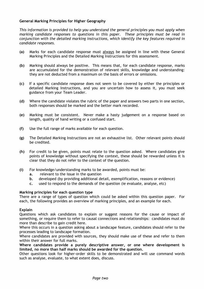
General Marking Principles for Higher Geography This information is provided to help you understand the general principles you must apply when marking candidate responses to questions in this paper. These principles must be read in conjunction with the detailed marking instructions, which identify the key features required in candidate responses. (a) Marks for each candidate response must always be assigned in line with these General
Marking Principles and the Detailed Marking Instructions for this assessment.
(b) Marking should always be positive. This means that, for each candidate response, marks are accumulated for the demonstration of relevant skills, knowledge and understanding: they are not deducted from a maximum on the basis of errors or omissions.
(c) If a specific candidate response does not seem to be covered by either the principles or detailed Marking Instructions, and you are uncertain how to assess it, you must seek guidance from your Team Leader.
(d) Where the candidate violates the rubric of the paper and answers two parts in one section,
both responses should be marked and the better mark recorded.
(e) Marking must be consistent. Never make a hasty judgement on a response based on length, quality of hand writing or a confused start.
(f) Use the full range of marks available for each question.
(g) The Detailed Marking Instructions are not an exhaustive list. Other relevant points should be credited.
(h) For credit to be given, points must relate to the question asked. Where candidates give points of knowledge without specifying the context, these should be rewarded unless it is clear that they do not refer to the context of the question.
(i) For knowledge/understanding marks to be awarded, points must be: a. relevant to the issue in the question
b. developed (by providing additional detail, exemplification, reasons or evidence)
c. used to respond to the demands of the question (ie evaluate, analyse, etc) Marking principles for each question type There are a range of types of question which could be asked within this question paper. For each, the following provides an overview of marking principles, and an example for each. Explain Questions which ask candidates to explain or suggest reasons for the cause or impact of something, or require them to refer to causal connections and relationships: candidates must do more than describe to gain credit here. Where this occurs in a question asking about a landscape feature, candidates should refer to the processes leading to landscape formation. Where candidates are provided with sources, they should make use of these and refer to them within their answer for full marks. Where candidates provide a purely descriptive answer, or one where development is limited, no more than half marks should be awarded for the question. Other questions look for higher-order skills to be demonstrated and will use command words such as analyse, evaluate, to what extent does, discuss.

Page three
Analyse Analysis involves identifying parts, the relationship between them, and their relationships with the whole. It can also involve drawing out and relating implications. An analysis mark should be awarded where a candidate uses their knowledge and understanding/ a source, to identify relevant components (eg of an idea, theory, argument, etc) and clearly show at least one of the following:
links between different components
links between component(s) and the whole
links between component(s) and related concepts
similarities and contradictions
consistency and inconsistency
different views/interpretations
possible consequences/implications
the relative importance of components
understanding of underlying order or structure Where candidates are asked to analyse they should identify parts of a topic or issue and refer to the interrelationships between, or impacts of, various factors, eg analyse the soil-forming properties which lead to the formation of a gley soil. Candidates would be expected to refer to how the various soil formatting properties contributed to the formation. Evaluate Where candidates are asked to evaluate, they should be making a judgement of the success, failure, or impact of something based on criteria. Candidates would be expected to briefly describe the strategy/project being evaluated before offering an evidenced conclusion. Account for Where candidates are being asked to account for, they are required to give reasons, often (but not exclusively) from a resource, eg for a change in trade figures, a need for water management, or differences in development between contrasting developing countries. Discuss These questions are looking for candidates to explore ideas about a project, or the impact of a change. Candidates will be expected to consider different views on an issue/argument. This might not be a balanced argument, but there should be a range of impacts or ideas within the answer. To what extent This asks candidates to consider the impact of a management strategy or strategies they have explored. Candidates would be expected to briefly describe the strategy/project being evaluated before offering an evidenced conclusion. Candidates do not need to offer an overall opinion based on a variety of strategies, but should assess each separately.

Page four
Detailed Marking Instructions for each question Section 1: Physical Environments
Question General marking principle for this type of question
Max Mark
Specific Marking Instruction for this question
1. Award 1 mark for a developed explanation, two limited explanations, or for a description of the discharge with limited explanation. Award a maximum of 2 marks for description of the discharge with 1 mark being awarded for every two descriptive points being made. Markers should accept all relevant and appropriate explanations for the source provided.
4 Slight increase in discharge until 09.00 hours in response to rain which started to fall at 07.00 hours (1 mark). At first, this rain would have been intercepted by vegetation and have infiltrated the soil (1 mark). There is a steep rising limb up to a peak discharge of 100 cumecs at 18.00 hours (1 mark). This water would have filled up storages in the soil due to throughflow and groundwater (1 mark) – as the soil became saturated, surface run-off increased causing a peak (1 mark). The rising limb becomes less steep briefly between 13.00 and 15.00 hours, caused by a marked reduction in rain to 4mm around 10.00 hours (1 mark). There is a short lag time of 5 hours which could be due to deforestation/steep slopes/impermeable rock (1 mark). A high number of tributaries may lead to the short lag time as water is transported more rapidly by surface run-off (1 mark).The river discharge quickly decreases, shown by a steep falling/recession limb down to because of no more rainfall after 15.00 hours (1 mark).

Page five
Question General marking principle for this type of question
Max Mark
Specific Marking Instructions for this question
2. Award a maximum of 4 marks for either feature.
Award a maximum of 6 marks if no diagrams are used.
Check any diagram(s) for relevant points not present in the text and award accordingly.
Well-annotated diagrams that explain conditions and processes can gain full marks.
Award a maximum of 1 mark for three or more correctly named, but undeveloped, processes.
Award a maximum of 2 marks for fully developed processes for any one feature.
Answers which are purely descriptive, or have no mention of any processes or conditions, should achieve no more than 2 marks in total, with 1 mark being awarded for every two descriptive points being made.
1 mark Limited explanation — the use of the names of at least two processes in context with no development of these.
7 Headland with weaknesses such as joints, faults or cracks is eroded by the sea to form firstly caves (1 mark). Erosion takes place due to hydraulic action - pounding waves compress trapped air in the rocks, creating an explosive blast which weakens and loosens rock fragments (1 mark),abrasion/corrasion – rock fragments thrown against the headland create a sandblasting (abrasive) action, wearing away the rock (1 mark), solution/corrosion – carbonic acid in sea water weathering limestone and chalk (1 mark), attrition – rock fragments slowly being ground down by friction from wave action into smaller and rounder pieces (1 mark). In some cases, a blowhole can form in the roof of the cave as compressed air is pushed upwards by the power of the waves, causing vertical erosion (1 mark). Over time, erosion on both sides of the headland cuts through the backwall and enlarges the cave to create an arch (1 mark). Continued erosion at the foot of the headland and the effects of vibrations on the roof of the arch weakens it, eventually resulting in the collapse of the arch roof, leaving a stack isolated from the headland (1 mark). These low ridges of sand or shingle slowly extend from the shore across a bay or a river estuary and are caused by longshore drift (1 mark). This lateral movement occurs when waves, driven by the prevailing wind, pushes material up the beach; known as the swash (1 mark). The returning backwash is dragged back by gravity down the beach at right angles (1 mark). Material slowly builds up to appear above the water and begins to grow longer and wider. The spit develops as long as the supply of deposits is greater than the amount of erosion (1 mark). Spits form when there is a change in direction on a coastline, which allows a sheltered area for deposition (1 mark). They can also develop at a bay or a river estuary where the river current prevents the spit from extending right across the bay or estuary (1 mark). The shape can change through time to become curved or hooked at the end in response to changes in wind direction and currents (1 mark).

Page six
Question General marking principle for this type of question
Max Mark
Specific Marking Instructions for this question
2 marks The use of the names of at least two processes with development of these, but no other reference to conditions. Or Limited use of the names of at least two processes, with at least two descriptive points about the landscape formation. 3 marks Two developed processes with limited explanation of how the feature forms over time. 4 marks Two named processes with development of these, with two further statements explaining the formation of the feature.

Page seven
Question General marking principle for this type of question
Max Mark
Specific Marking Instructions for this question
3. Award 1 mark for each developed explanation or for two less developed points. Candidates should be awarded 1 mark if they only name and locate at least two cells/winds, not credited elsewhere. Credit any valid responses.
4 Warm air rises at the Equator and travels in the upper atmosphere to around 300 N and S, cools and sinks (1 mark). Air moves from the tropical high to the low pressure area at the equator creating the Hadley cell/Trade Winds (1 mark) Cold air sinking at the poles moves to 60oN/S to form the Polar Cell/Polar Easterlies (1 mark). The cold air from the poles meets warmer air from the tropics, causing air to rise creating the Ferrel Cell low pressure. (1 mark) Air is moved from the tropical HP, towards LP at the polar front, forming the westerlies (1 mark) This convergence causes the air to rise, with some of this flowing in the upper atmosphere to the Poles where it sinks, forming the Polar cell. Easterly winds blow away from the high pressure at the Pole. (1 mark). Warm air from the Equator is distributed to higher and cooler latitudes and cold air from the Poles distributed to lower and warmer latitudes (1 mark). Due to the Coriolis effect winds are deflected to the right in the northern hemisphere (1 mark). Credit should be awarded for answers which refer to the Rossby Waves and/or the Jet Stream

Page eight
Section 2: Human Environments
Question General marking principle for this type of question
Max Mark
Specific Marking Instruction for this question
4. Candidates should discuss the positive or negative consequences of the predicted population structure in 2050. For 1 mark, candidates may give one detailed consequence, or a limited description/explanation of two factors. Detail may include relevant exemplification of a problem. A maximum of 2 marks should be awarded for answers consisting entirely of limited descriptive/explanatory points, with two such points required for one mark. Care should be taken not to ensure consequences are relevant to developing countries. Credit any other valid responses
5 Possible answers may include:
The total population will increase significantly putting additional pressure on services and resources like education (1 mark).. Housing in Ghana, like many developing countries, is already overcrowded. This problem is likely to continue, with many people being forced to live in shanty town housing (1 mark).
There will be a much larger potential workforce which may attract multinational companies to the country (1 mark). An increase in the active age group, however, could also result in higher levels of unemployment or underemployment (1 mark).
In total, there will be twice as many children, so significant investment in maternity hospitals, immunisation programmes and education will be needed (1 mark). It will be necessary to build more schools and train more teachers to support the growing number of young people (1 mark).
Government policies may promote smaller families or encourage emigration to reduce the problems of over-population (1 mark).
With life expectancy increasing, it will also be necessary to invest in health-care to meet the needs of an ageing population in the future (1 mark).

Page nine
Question General marking principle for this type of question
Max Mark
Specific Marking Instructions for this question
5. Answers will depend on the case study referenced by the candidate. Marks may be awarded as follows: For 1 mark, candidates may give one detailed explanation, or a limited description/explanation of two factors. A maximum of 2 marks should be awarded for answers consisting entirely of limited descriptive points, with two such points required for one mark. A maximum of 4 marks should be awarded if the answer does not clearly relate to a specific case study. Credit any other valid responses
5 For candidates who write about Glasgow, possible answers might include:
Bypass/ring road: In Glasgow, the M74, M77 or Glasgow Southern Orbital Route mean that through traffic does not need to travel into the city centre (1 mark).
Pedestrianised area in centre: sections of Argyle Street and Buchanan Street were pedestrianised, the main shopping streets are no longer congested to make it safer and more pleasant for shoppers (1 mark).
Park and ride and improvements to public transport: Commuters have been encouraged to travel into the city centre by train, underground or bus to reduce the number of cars on the road (1 mark). Additional parking has been provided at suburban train stations, eg Hamilton West and Carluke, and new railway stations have opened, eg Larkhall (1 mark). The introduction of bus lanes has reduced journey times along main commuter routes, therefore encouraging people to travel by bus (1 mark).
One way streets: To improve the flow of traffic, the streets around George Square and Hope Street are now one way (1 mark).
Parking restrictions and fines: parking charges have been increased (60p for 12 minutes in the city centre, with a maximum stay of 2 hours) and traffic wardens patrol the streets to discourage people from bringing their cars into the centre (£60 fines are issued as necessary) (1 mark).
Multi-storey car parks: Multi storey car parks have been built, eg Buchanan Galleries, to reduce the number of cars parking on the surrounding streets (1 mark).
Bridges and tunnels: Bridges like the Clyde Arc (‘Squinty Bridge’) and the Clyde Tunnel have been built to improve the flow of traffic from the north to the south of the city, diverting from the CBD thus reducing congestion (1 mark).
Page ten
Question General marking principle for this type of question
Max Mark
Specific Marking Instructions for this question
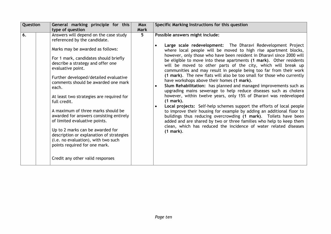
6. Answers will depend on the case study referenced by the candidate.
Marks may be awarded as follows:
For 1 mark, candidates should briefly describe a strategy and offer one evaluative point.
Further developed/detailed evaluative comments should be awarded one mark each.
At least two strategies are required for full credit.
A maximum of three marks should be awarded for answers consisting entirely of limited evaluative points.
Up to 2 marks can be awarded for description or explanation of strategies (i.e. no evaluation), with two such points required for one mark.
Credit any other valid responses
5 Possible answers might include:
Large scale redevelopment: The Dharavi Redevelopment Project where local people will be moved to high rise apartment blocks, however, only those who have been resident in Dharavi since 2000 will be eligible to move into these apartments (1 mark). Other residents will be moved to other parts of the city, which will break up communities and may result in people being too far from their work (1 mark). The new flats will also be too small for those who currently have workshops above their homes (1 mark).
Slum Rehabilitation: has planned and managed improvements such as upgrading mains sewerage to help reduce diseases such as cholera however, within twelve years, only 15% of Dharavi was redeveloped (1 mark).
Local projects: Self-help schemes support the efforts of local people to improve their housing for example by adding an additional floor to buildings thus reducing overcrowding (1 mark). Toilets have been added and are shared by two or three families who help to keep them clean, which has reduced the incidence of water related diseases (1 mark).

Page eleven
Section 3: Global Issues
Question General marking principle for this type of question
Max Mark
Specific Marking Instructions for this question
7. (a) 1 mark should be awarded for each detailed explanation.
Award a maximum of 4 marks if only human or physical factors are explained (although a physical factor could be linked to a human issue, for example narrow cross section which would reduce the cost) A maximum of 2 marks should be awarded for answers consisting entirely of limited descriptive points, with two such points required for one mark. Credit any other valid responses
5 Narrow cross section of the valley is required in order to reduce construction costs of the dam (1 mark). A deep valley is required behind the dam as this will result in a smaller surface area for the reservoir, thereby reduce loss from evaporation (1 mark). A site which has impermeable rock would be advantageous as this would reduce loss from the reservoir by percolation (1 mark). A site which is close to construction materials would help to reduce the cost of transporting these materials to the construction site (1 mark). An area free from earthquakes or subsidence is needed as the area needs to be able to support the weight of a large dam (1 mark). A site close to areas of farmland or urban areas would help to reduce water/electrical loss during transportation (1 mark). The costs involved in moving people who live in the area to be flooded, to reduce costs for compensation and re-housing (1 mark). The land which is to be flooded should not be valuable, for example high quality farmland or of historic/environmental importance (1 mark). An area with plentiful supply of snowmelt/rainfall/river water is required to ensure a consistently high volume of water in the reservoir (1 mark).
Page twelve
Question General marking principle for this type of question
Max Mark
Specific Marking Instructions for this question
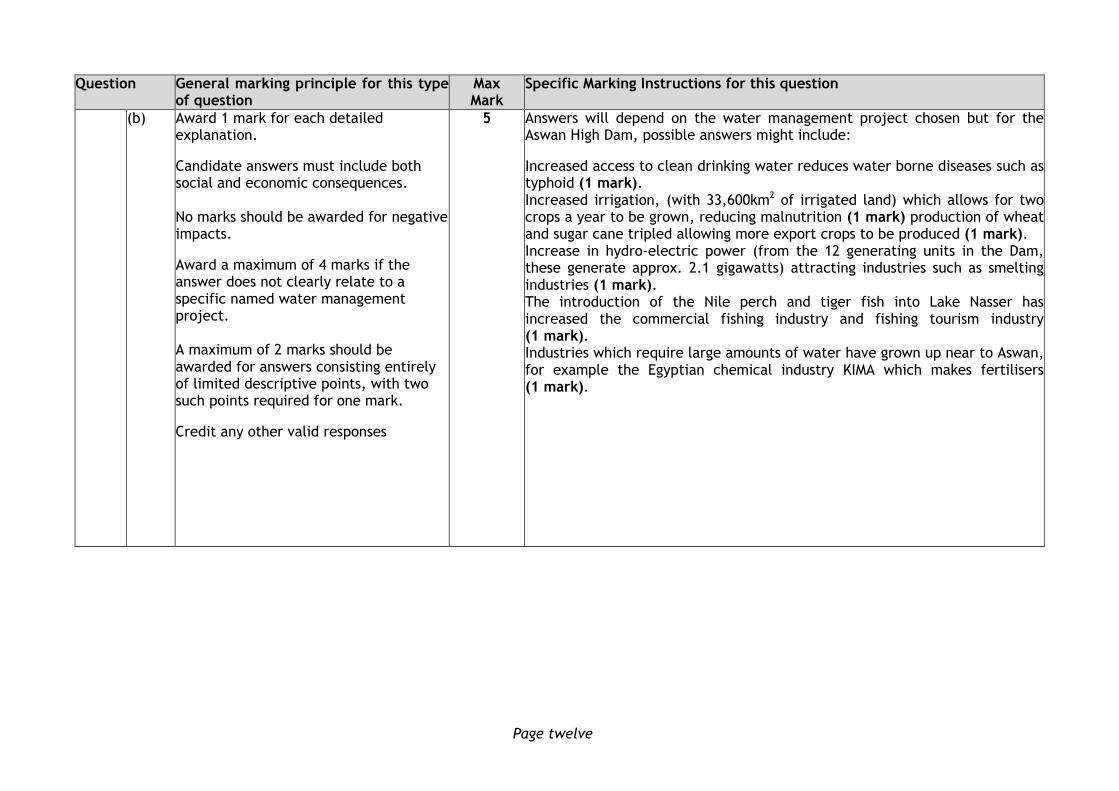
(b) Award 1 mark for each detailed explanation.
Candidate answers must include both social and economic consequences. No marks should be awarded for negative impacts.
Award a maximum of 4 marks if the answer does not clearly relate to a specific named water management project. A maximum of 2 marks should be awarded for answers consisting entirely of limited descriptive points, with two such points required for one mark.
Credit any other valid responses
5 Answers will depend on the water management project chosen but for the Aswan High Dam, possible answers might include:
Increased access to clean drinking water reduces water borne diseases such as typhoid (1 mark). Increased irrigation, (with 33,600km2 of irrigated land) which allows for two crops a year to be grown, reducing malnutrition (1 mark) production of wheat and sugar cane tripled allowing more export crops to be produced (1 mark). Increase in hydro-electric power (from the 12 generating units in the Dam, these generate approx. 2.1 gigawatts) attracting industries such as smelting industries (1 mark). The introduction of the Nile perch and tiger fish into Lake Nasser has increased the commercial fishing industry and fishing tourism industry (1 mark). Industries which require large amounts of water have grown up near to Aswan, for example the Egyptian chemical industry KIMA which makes fertilisers (1 mark).

Page thirteen
Question General marking principle for this type of question
Max Mark
Specific Marking Instructions for this question
8. (a) 1 mark should be awarded for each detailed comparison, or a comparison with a short explanation. A detailed comparison will contain a qualitative statement such as dramatically higher and be supported by the statistics. A maximum of 2 marks should be awarded for answers which are purely descriptive and do not go beyond making comparisons d directly from the table, with two such comparisons required for one mark. Where candidates refer only to the headings (i.e. not to the data), a maximum of one mark should be awarded. Markers should take care to look for comparisons wherever they occur in a candidate’s answer. Credit any other valid responses
4 GDP per person shows that Brazil, Mexico and Cuba are emergent developing countries with an intermediate level of income, while Kenya and Malawi are still classed as low income developing countries (1 mark). Employment in agriculture is far higher in Malawi (90%) than Brazil at 16% so it is less industrialised (1 mark). Adult literacy is far higher in Brazil, Mexico and Cuba than in Malawi suggesting they have more schools (1 mark). Birth rate shows a vast difference in development with both African countries having high birth rates (Kenya – 30%); compared with Mexico at 18%, suggesting lack of contraception/education (1 mark). There is also a large difference between the country with the poorest life - Malawi has a life expectancy of 53 whereas Cuba is 78, suggesting better health care. (1 mark).
Page fourteen
Question General marking principle for this type of question
Max Mark
Specific Marking Instructions for this question
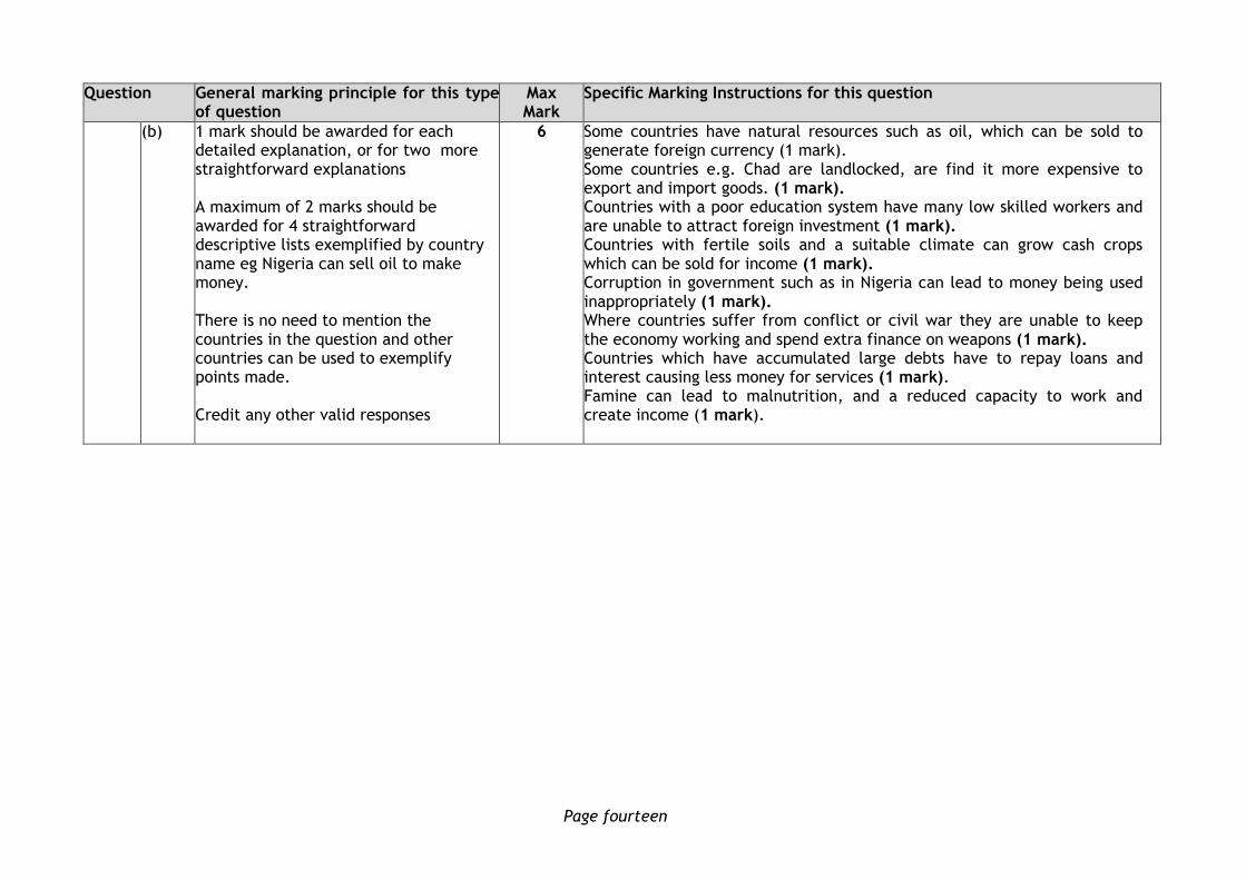
(b) 1 mark should be awarded for each detailed explanation, or for two more straightforward explanations A maximum of 2 marks should be awarded for 4 straightforward descriptive lists exemplified by country name eg Nigeria can sell oil to make money. There is no need to mention the countries in the question and other countries can be used to exemplify points made. Credit any other valid responses
6 Some countries have natural resources such as oil, which can be sold to generate foreign currency (1 mark). Some countries e.g. Chad are landlocked, are find it more expensive to export and import goods. (1 mark). Countries with a poor education system have many low skilled workers and are unable to attract foreign investment (1 mark). Countries with fertile soils and a suitable climate can grow cash crops which can be sold for income (1 mark). Corruption in government such as in Nigeria can lead to money being used inappropriately (1 mark). Where countries suffer from conflict or civil war they are unable to keep the economy working and spend extra finance on weapons (1 mark). Countries which have accumulated large debts have to repay loans and interest causing less money for services (1 mark). Famine can lead to malnutrition, and a reduced capacity to work and create income (1 mark).

Page fifteen
Question General marking principle for this type of question
Max Mark
Specific Marking Instructions for this question
9. (a) No marks should be awarded for naming the greenhouse gases as these are included in the diagram. No marks should be awarded for explanations of the enhanced greenhouse effect as this is included in the diagram. 1 mark should be awarded for each detailed explanation, or for two undeveloped points. Undeveloped points may include comparative potency of each gas, or limited reasons for increase. Markers should take care not to credit the same reason twice eg car ownership. Credit any other valid responses.
4 Possible answers might include: The Enhanced Greenhouse effect has been caused by an increase in greenhouse gases within the atmosphere. Carbon Dioxide (remains in the atmosphere for 100 years)
Burning fossil fuels, for example coal, oil and natural gas release Carbon Dioxide into the atmosphere, which will trap heat. Coal has been used increasingly to power factories, generate electricity in power stations and to heat homes (1 mark).
Increased car ownership has resulted in more petrol and diesel being used to fuel cars (1 mark).
Deforestation, especially in the Amazon Rainforest, has resulted in more carbon dioxide being absorbed, and the burning releases more C02. (1 mark).
Peat bog reclamation (particularly in Scotland and Ireland) during, for example, the construction of wind farms, has also resulted in additional Carbon dioxide being released into the atmosphere (1 mark).
Methane: (More than 20 times as effective in trapping heat than CO2; accounts for 20% of the enhanced greenhouse effect; remains in the atmosphere for 11-12 years) (1 mark).
Methane has been released from landfill sites as waste decomposes and when drilling for natural gas (1 mark).
The increase in padi fields to feed rapidly growing populations in Asian countries has increased the amount of methane in the atmosphere (1 mark).
The increasing demand for beef has resulted in more methane being created by belching cattle and from animal dung (1 mark).

Page sixteen
Question General marking principle for this type of question
Max Mark
Specific Marking Instructions for this question
Nitrous oxide:
Nitrous oxide is 200-300 times more effective in trapping heat than Carbon Dioxide. Increased car exhaust emissions have resulted in more Nitrous Oxide (1 mark).
Due to rising food demand the increased production of fertilisers also adds to the amount of Nitrous Oxide in the atmosphere (1 mark).
Chlorofluorocarbons (CFCs):
Refrigerators which are not disposed of correctly release CFCs when the foam insulation inside them is shredded. (1 mark).
Air-conditioning – the coolants used in air conditioning systems create CFCs, which must be disposed of correctly (1 mark).
Credit any relevant developed points.

Page seventeen
Question General marking principle for this type of question
Max Mark
Specific Marking Instructions for this question
(b) For 1 mark, candidates should give one detailed explanation, or a limited description/explanation of two factors. A maximum of 4 marks should be awarded for answers consisting entirely of limited descriptive points, with two such points required for one mark. A maximum of 2 marks should be awarded for answers consist of limited description with a specific example. 1 mark can be awarded where candidates refer to two specific named examples accurately linked with an effect (species, ocean currents, or use of figures). Candidates should be credited for both positive and negative effects. Credit any other valid responses
6 Possible answers might include: Global Effects:
Sea level rises caused by an expansion of the sea as it becomes warmer and also by the melting of glaciers and ice caps in Greenland, Antarctica, etc (1 mark).
Low–lying coastal areas, eg Bangladesh affected with large-scale displacement of people and loss of land for farming and destruction of property (1 mark).
More extreme and more variable weather, including floods, droughts, hurricanes, tornadoes becoming more frequent and intense (1 mark).
Globally, an increase in precipitation, particularly in the winter in northern countries such as Scotland, but some areas like the USA Great Plains may experience drier conditions (1 mark).
Increase in extent of tropical/vector borne diseases, eg yellow fever as warmer areas expand, possibly up to 40 million more in Africa being exposed to risk of contracting malaria (1 mark).
Longer growing seasons in many areas in northern Europe for example, increasing food production and range of crops being grown (1 mark).
Impact on wildlife and natural habitats, eg extinction of at least 10% of land species and coral reefs suffer 80% bleaching (1 mark).
Changes to ocean current circulation, eg in the Atlantic the thermohaline circulation starts to lose impact on north–western Europe, resulting in considerably colder winters (1 mark).
Changes in atmospheric patterns linking to changes in the monsoon caused by El Nino, La Nina (1 mark).
Increased risk of forest fires, for example in Australia and California due to change in surface temperatures and changes in rainfall patterns (1 mark).

Page eighteen
Question General marking principle for this type of question
Max Mark
Specific Marking Instructions for this question
10. (a) Candidates should refer to both social and economic impacts for full credit, although markers should be aware that many impacts could be considered both social and economic. 1 mark should be awarded for each detailed explanation. A maximum of 3 marks should be awarded for answers consisting entirely of limited points, with two such points required for one mark. A developed point may be a detailed explanation of an impact, or may be two less detailed impacts. Candidates may choose to answer a mixture of two styles. Credit any other valid responses
4 Possible answers might include:
Economic impacts include many people being trapped in poverty and trying to survive on very little money. This might be because companies in the developed world want to manufacture their product for the cheapest price possible (1 mark).
Many countries are unable to make a decent profit on the goods they sell because they are forced to pay tariffs to ‘developed countries’ in trading blocs (1 mark).
Government subsidies and grants in ‘developed countries’ allow companies to sell products (eg rice and grain) at a cheaper price than is possible in many ‘developing countries’ – undercutting local farmers and causing them to lose money (1 mark).
Social impacts of this poverty include many children working instead of going to school, and this causes an illiterate population, with the consequent lack of opportunities and poorer quality of living for people that this applies to (1 mark).
Creates a self-perpetuating cycle of poverty where the next generation are unable to access well paid employment due to being illiterate (1 mark).
The lack of well-paid jobs means many people live in shanty town type accommodation, with little access to clean water, safe electricity, sanitation etc (1 mark).
Page nineteen
Question General marking principle for this type of question
Max Mark
Specific Marking Instructions for this question
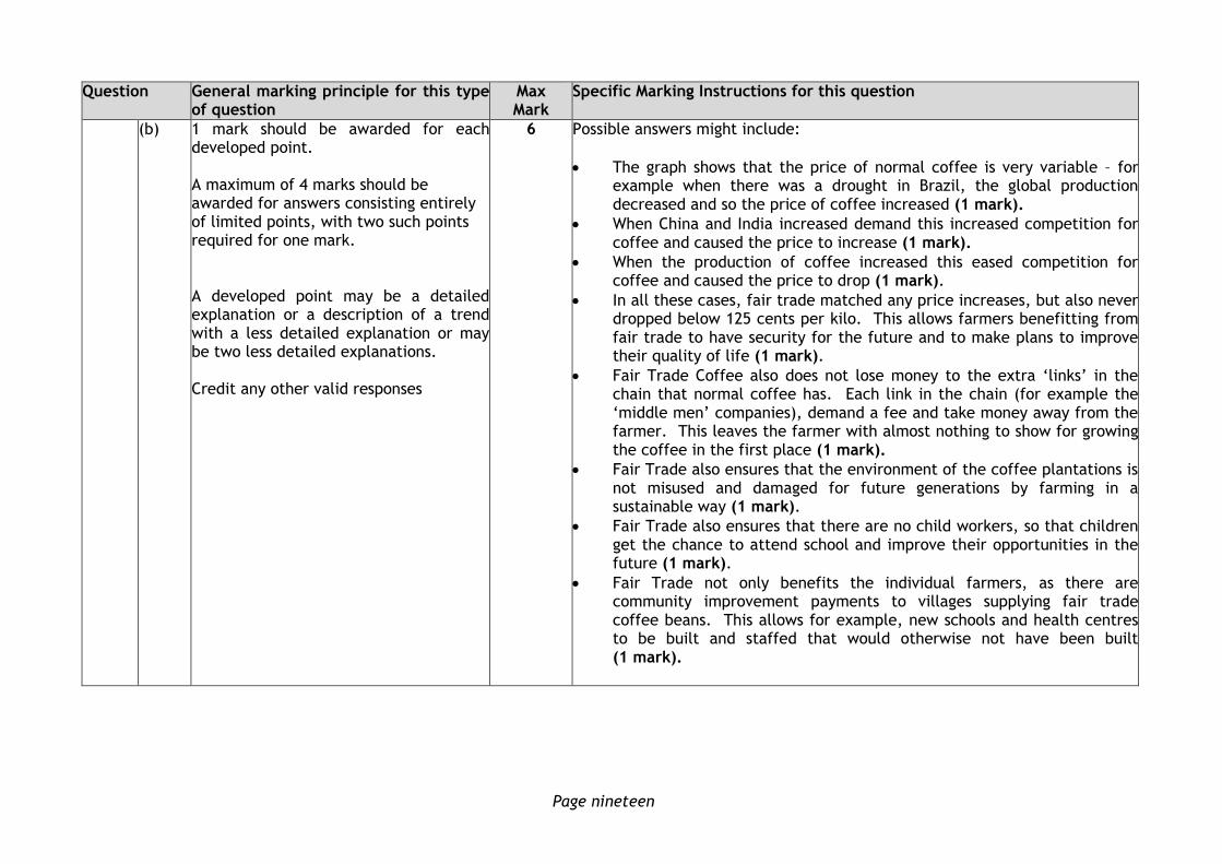
(b) 1 mark should be awarded for each developed point. A maximum of 4 marks should be awarded for answers consisting entirely of limited points, with two such points required for one mark. A developed point may be a detailed explanation or a description of a trend with a less detailed explanation or may be two less detailed explanations. Credit any other valid responses
6 Possible answers might include:
The graph shows that the price of normal coffee is very variable – for example when there was a drought in Brazil, the global production decreased and so the price of coffee increased (1 mark).
When China and India increased demand this increased competition for coffee and caused the price to increase (1 mark).
When the production of coffee increased this eased competition for coffee and caused the price to drop (1 mark).
In all these cases, fair trade matched any price increases, but also never dropped below 125 cents per kilo. This allows farmers benefitting from fair trade to have security for the future and to make plans to improve their quality of life (1 mark).
Fair Trade Coffee also does not lose money to the extra ‘links’ in the chain that normal coffee has. Each link in the chain (for example the ‘middle men’ companies), demand a fee and take money away from the farmer. This leaves the farmer with almost nothing to show for growing the coffee in the first place (1 mark).
Fair Trade also ensures that the environment of the coffee plantations is not misused and damaged for future generations by farming in a sustainable way (1 mark).
Fair Trade also ensures that there are no child workers, so that children get the chance to attend school and improve their opportunities in the future (1 mark).
Fair Trade not only benefits the individual farmers, as there are community improvement payments to villages supplying fair trade coffee beans. This allows for example, new schools and health centres to be built and staffed that would otherwise not have been built (1 mark).

Page twenty
Question General marking principle for this type of question
Max Mark
Specific Marking Instructions for this question
11. (a) 1 mark should be awarded for each developed point for energy production or for two undeveloped points. A developed point may include a descriptive statistic/comparative statement with explanation or a developed explanation. Where candidates have only described the data, award a maximum of 1 mark. 1 mark should be awarded for two descriptive points. Credit any other valid responses
4 Possible answers might include:
Saudi Arabia gets 100% of its energy from fossil fuels because it has vast natural resources of oil and gas in its territory (1 mark).
Portugal has the largest amount of other renewables because its climate is sunny, with many cloud-free days for solar power (1 mark) and windy with mid-latitude westerly winds blowing over Atlantic Ocean to Portugal for wind power (1 mark).
France has the largest amount of nuclear energy because it has no oil or gas reserves and has used up most of its coal reserves (1 mark). France used to import oil and gas, but started to develop its own nuclear power in a big way after the “oil shock” – when OPEC countries suddenly decided to quadruple the price for oil in 1973 (1 mark).
Paraguay has the largest amount of Hydroelectric Power because it has large amounts of tropical precipitation and major rivers that can be harnessed (1 mark).
Iceland has the largest amount of geothermal energy because it is located at a plate boundary where the heat of magma is closer to the surface and so can be harnessed efficiently (1 mark).

Page twenty-one
Question General marking principle for this type of question
Max Mark
Specific Marking Instructions for this question
(b) 1 mark should be awarded for each developed explanatory point or for two undeveloped points. Take care not to credit reverse statements (for example renewable sources do not pollute and non-renewable sources pollute). Maximum of 4 marks for one energy source.
Credit any other valid responses
6 Possible answers for all renewable energy sources might include:
It harnesses a free resource, which is sustainable for the future (1 mark). It does not contribute greenhouse gases such as CO2 or other pollution in to the atmosphere (1 mark).
Also, for:
Wind Power can be very effective if sited properly in an exposed area where there is regular wind flow to turn the blades (1 mark). A large area of open land is required, close to large cities, for both wind and solar to avoid loss when transporting (1 mark). However, when the wind is not blowing the turbines cannot generate any energy, and at present it is very difficult to store wind power to use when demand needs it (1 mark). Wind Turbines built on peat bogs require the bogs to be drained – which releases Carbon Dioxide that would otherwise have been stored – causing pollution (1 mark).
Solar Power is effective on clear, sunny days but is far less effective when clouds block direct sunlight (1 mark). Solar power can be stored in batteries and used at times of high demand (1 mark). Photostatic panels and solar panels have a very high initial cost. (1 mark).
Hydroelectric Power can be generated as required and so is able to cope with peaks and troughs in demand (1 mark).
Geothermal Power can be generated as required and so is able to cope with peaks and troughs in demand (1 mark). It is most effective in areas close to plate boundaries where the heat source underground (magma) is closer to the surface (1 mark).
Tidal power has the potential to generate vast quantities of energy. Eg experimental tidal generators in the Pentland Firth (1 mark). Tidal power, unlike wind/solar is predictable, therefore reliable. (1 mark).
Technology for wave power, is not yet sufficiently advanced to allow for large scale economic production. (1 mark).
Page twenty-two
Question General marking principle for this type of question
Max Mark
Specific Marking Instructions for this question
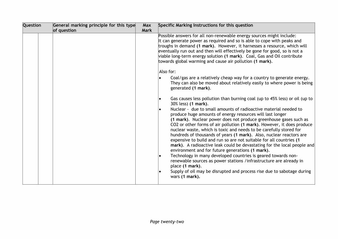
Possible answers for all non-renewable energy sources might include: It can generate power as required and so is able to cope with peaks and troughs in demand (1 mark). However, it harnesses a resource, which will eventually run out and then will effectively be gone for good, so is not a viable long-term energy solution (1 mark). Coal, Gas and Oil contribute towards global warming and cause air pollution (1 mark).
Also for:
Coal/gas are a relatively cheap way for a country to generate energy. They can also be moved about relatively easily to where power is being generated (1 mark).
Gas causes less pollution than burning coal (up to 45% less) or oil (up to 30% less) (1 mark).
Nuclear - due to small amounts of radioactive material needed to produce huge amounts of energy resources will last longer (1 mark). Nuclear power does not produce greenhouse gases such as CO2 or other forms of air pollution (1 mark). However, it does produce nuclear waste, which is toxic and needs to be carefully stored for hundreds of thousands of years (1 mark). Also, nuclear reactors are expensive to build and run so are not suitable for all countries (1 mark). A radioactive leak could be devastating for the local people and environment and for future generations (1 mark).
Technology in many developed countries is geared towards non-renewable sources as power stations /infrastructure are already in place (1 mark).
Supply of oil may be disrupted and process rise due to sabotage during wars (1 mark).

Page twenty-three
Question General marking principle for this type of question
Max Mark
Specific Marking Instructions for this question
12. Candidates should make reference to all sources, including the OS map to discuss the suitability and impact of the centre.
1 mark should be awarded for each developed explanatory point
1mark should be awarded where candidates refer to the resource and offer a brief explanation of its significance (beyond the wording of the resource), or give a limited description/explanation of two factors. A maximum of 5 marks should be awarded for answers consisting entirely of limited descriptive points, with two such points required for one mark. A maximum of 4 marks should be awarded for candidates who give vague over-generalised answers, which make no reference to the map.
10 For suitability, possible answers may include the following positive observations:
Possible advantages of this location The surrounding area offers potential for a range of activities such as hillwalking, with steep slopes posing a challenge for mountain biking eg Auchenroy Hill (1 mark), there are numerous trails in nearby woodland which could be used for orienteering eg Galloway Forest Park 488038 (1 mark). Steep, sheer cliffs in the disused quarry at 457054 could be used for abseiling/climbing (1 mark). There are a number of opportunities for watersports such as the River Doon could be used for fishing, or the River Doon and Bogton Loch/Loch Doon could be used for kayaking (1 mark). Local schools at 477060 may be interested in using the facilities for outdoor learning and enriching the curriculum. The SSSI at Bogton Loch and the Nature Reserve at Dalmellington Moss would offer opportunities for exploring the wildlife present (1 mark). Variety of attractive scenery including Dalcairnie Linn waterfall offering potential for geography studies (as per spec) at 467043 (1 mark). There are a number of tourist facilities already in the area (Industrial Railway Centre, Horse Riding, Fishing), and these could work together with the new facility to join up and benefit from each other’s custom (1 mark). The centre would be only 0.5 km from the A713 main road and there is access to the site at present, with the B741 to the west and a minor road lying to the east (1 mark). Possible disadvantages of this location Large area of marsh/poorly drained land close to the site would present major construction difficulties and could result in expensive remediation work (1 mark). There could be a serious threat of flooding from the loch overflowing after heavy precipitation (1 mark).
Page twenty-four
Question General marking principle for this type of question
Max Mark
Specific Marking Instructions for this question
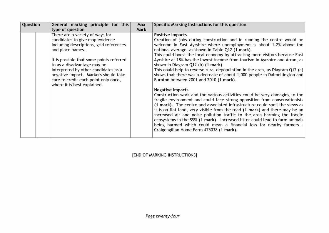
There are a variety of ways for candidates to give map evidence including descriptions, grid references and place names. It is possible that some points referred to as a disadvantage may be interpreted by other candidates as a negative impact. Markers should take care to credit each point only once, where it is best explained.
Positive Impacts Creation of jobs during construction and in running the centre would be welcome in East Ayrshire where unemployment is about 1-2% above the national average, as shown in Table Q12 (1 mark). This could boost the local economy by attracting more visitors because East Ayrshire at 18% has the lowest income from tourism in Ayrshire and Arran, as shown in Diagram Q12 (b) (1 mark). This could help to reverse rural depopulation in the area, as Diagram Q12 (a) shows that there was a decrease of about 1,000 people in Dalmellington and Burnton between 2001 and 2010 (1 mark). Negative Impacts Construction work and the various activities could be very damaging to the fragile environment and could face strong opposition from conservationists (1 mark). The centre and associated infrastructure could spoil the views as it is on flat land, very visible from the road (1 mark) and there may be an increased air and noise pollution traffic to the area harming the fragile ecosystems in the SSSI (1 mark). Increased litter could lead to farm animals being harmed which could mean a financial loss for nearby farmers - Craigengillan Home Farm 475038 (1 mark).
[END OF MARKING INSTRUCTIONS]


![2003 Mathematics Advanced Higher Finalised Marking ...€¦ · [END OF MARKING INSTRUCTIONS] * optional Page 5. 2003 Mathematics Advanced Higher – Section B Finalised Marking Instructions.](https://static.fdocuments.us/doc/165x107/6062cbe71ae222684b2c8a01/2003-mathematics-advanced-higher-finalised-marking-end-of-marking-instructions.jpg)