Terry Barber Commissioner Precinct 1 Commissioner Precinct 3

2014 Hartbeespoort Area Precinct Plan
40 Chapter 3: Precinct Analysis
R514R514R514R514R514R514R514R514R514
R511R511R511R511R511R511R511R511R511
R511R511R511R511R511R511R511R511R511
R511R511R511R511R511R511R511R511R511
R560R560R560R560R560R560R560R560R560
R512R512R512R512R512R512R512R512R512
R512R512R512R512R512R512R512R512R512
R512R512R512R512R512R512R512R512R512
R560R560R560R560R560R560R560R560R560
R104R104R104R104R104R104R104R104R104
R560R560R560R560R560R560R560R560R560
R104R104R104R104R104R104R104R104R104
R512R512R512R512R512R512R512R512R512
N4 N4N4N4N4N4N4N4N4N4
IfafiIfafiIfafiIfafiIfafiIfafiIfafiIfafiIfafi
XanaduXanaduXanaduXanaduXanaduXanaduXanaduXanaduXanadu
DamsigDamsigDamsigDamsigDamsigDamsigDamsigDamsigDamsig
Hartbeespoort Area PrecinctPlan
0 0.5 1 2 3 4 5 km
NEngineering Services
Legend
Precinct Boundary
Townships
Ridges
Hartbeespoort Dam
Perennial Rivers
Roads and Transportation
National Roads
Main Roads
National Roads
Regional Roads
Regional Roads
Engineering Services
Reservoir Supply Zone
Bulk Water Pipelines
Existing Reservoirs
Water Purification
Waste Water Treatment Works
Electricity Substation
Railway
Railway Line
Stations
Figure 17: Engineering Services
2014Hartbeespoort Area Precinct Plan
41Chapter 3: Precinct Analysis
3.4.2 Water Supply
3.4.2.1 Water Supply to the East of the Hartbeespoort Dam
The existing water network was previously divided into two separate networks orpressurezones.
TheNorthernNetworkiscurrentlysuppliedfromtheLocalMunicipalityofMadibeng’s10Mℓ/day water treatment works in Karel Street and the supply area includes forSchoemansville,MelodieandMelodieAgriculturalHoldings.ThisnetworkfunctionsasanindependentpressurezoneandRoadR511formstheborderbetweenthenorthernandsouthernnetworks.
TheSouthernNetworkincludes,interalia,Ifafi,MeerhofandXanaduEcoPark.ThisnetworkissupplieddirectlyfromtheRandWaterH36APipelineandfunctionsasanindependentpressurezone.
Newdevelopments in thisareawillbesuppliedwithpotablewater fromtheexistingwaternetwork.
3.4.2.2 Water Supply to the Areas North and North West of the Hartbee-spoort Dam
PotablewaterispumpedfromthewatertreatmentworksinKarelStreettothestoragereservoirinKosmos.PotablewaterisgravitatedtoKosmosanddevelopmentsdirectlytothewestofKosmosuptoCaribbeanBeachClubaswellasMagaliesPark.
Developments between Caribbean Beach Club and Magaliespark i.e. Leloko arecurrentlysuppliedfromboreholes.
Water to the proposed agricultural uses to the north of the existing estates will besuppliedfromboreholes.Watersupplyfromthelocalauthoritywillbetooexpensivetomakeagriculturalactivitiesfeasible.
3.4.2.3 Water Supply to the Areas South and South West of the Hartbee-spoort Dam
Developments to the south and the south west of the Hartbeespoort Dam are allsuppliedwithwaterfromexistingboreholes.
RandWaterdidplanasupplypipelinefromtheH36AatXanadufollowingtherailwaylineandcrossingthedamto terminateatLeloko. Duetodifferenceswith theLocalMunicipalityofMadibengitseemsasiftheconstructionofthispipelinehasbeenputpermanentlyonhold.
Water to the proposed agricultural uses to the south of the existing estateswill besuppliedfromboreholes.
3.4.3 Sewer
3.4.3.1 Handling of Sewerage to the east of the Hartbeespoort Dam
Thenaturaldrainagepatternon theeasternsideof theHartbeespoortDam is fromnortheastandeastinawesterndirectiontowardstheHartbeespoortDam.
Currentlyseweragedraintovariousseweragepumpstationsfromwherethesewerageispumpedtothe3Mℓ/dayRietfonteinWasteWaterTreatmentWorks(WWTW).
SeweragefromnewdevelopmentsinthisareawilleitherdraindirectlyorwillbepumpedtotheRietfonteinWasteWaterTreatmentWorks.
3.4.3.2 Handling of Sewerage to the areas north and north west of the Hartbeespoort Dam
No municipal sewer services are available in the direct vicinity of the proposeddevelopments.

2014 Hartbeespoort Area Precinct Plan
42 Chapter 3: Precinct Analysis
3.4.3.3 Handling of Sewerage to the areas south and south west of the Hartbeespoort Dam
No municipal sewer services are available in the direct vicinity of the proposeddevelopments.
3.5 Economy
According to the Madibeng Local Economic Development Strategy, 2008, theHartbeespoortdamisthesecondmostvisiteddestinationaftertheWaterfrontinCapeTown.Itisestimatedthatbetween19,000to20,000vehiclesdriveperweekendovertheHartbeespoortdamwall.8AccordingtotheMadibengTourismMasterPlan,2008theHartbeespoortareaisthemostpopulardestinationintheMunicipality,followedbytheMagaliesberg.Hartbeespoorthasthelargestshareofalltourismfacilitiesaccountingfor71%oftourismfacilitiesinthemunicipality.9
3.6 Socio-Economic Profile
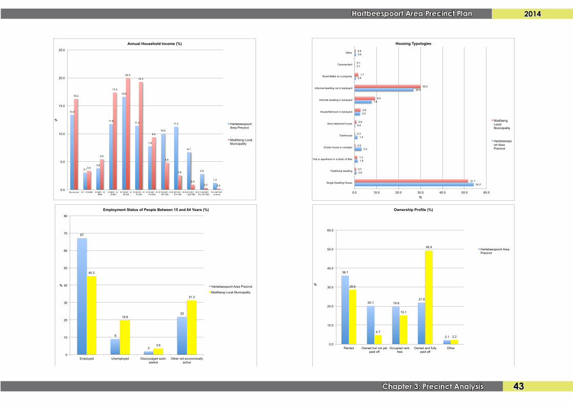
Thestudyareacomprisesa totalpopulationof28,694people (ofwhich20,692areclassifiedasurban)and11,377households.This is6%of the totalMadibengLocalMunicipality(MLM)population.Theaveragehouseholdsizeis4.5people.Theareahasthefollowingsocio-economicprofile:
• 9%ofthepopulationbetweentheagesof15and64yearsareunemployed(20%forMLM);
• ±49%ofhouseholdshaveanannualhouseholdincomeoflessthanR38,500(62.4%inMLM)while±4%ofhouseholdshaveanannualhouseholdincomeofmorethanR1,228,801asopposedtoonly0.6%ofhouseholdsinMLM;
8 Source: Madibeng Local Economic Development Strategy, 2008
9 Source: Madibeng Tourism Master Plan, 2008
• 54%ofhouseholdsresideinsingledwellinghouses,while27%resideininfor-malstructuresininformalsettlements;
• 42%ofhouseholdsowntheirdwellings(eitherpaidofforstillbeingpaidoff)while36%renttheirproperties;
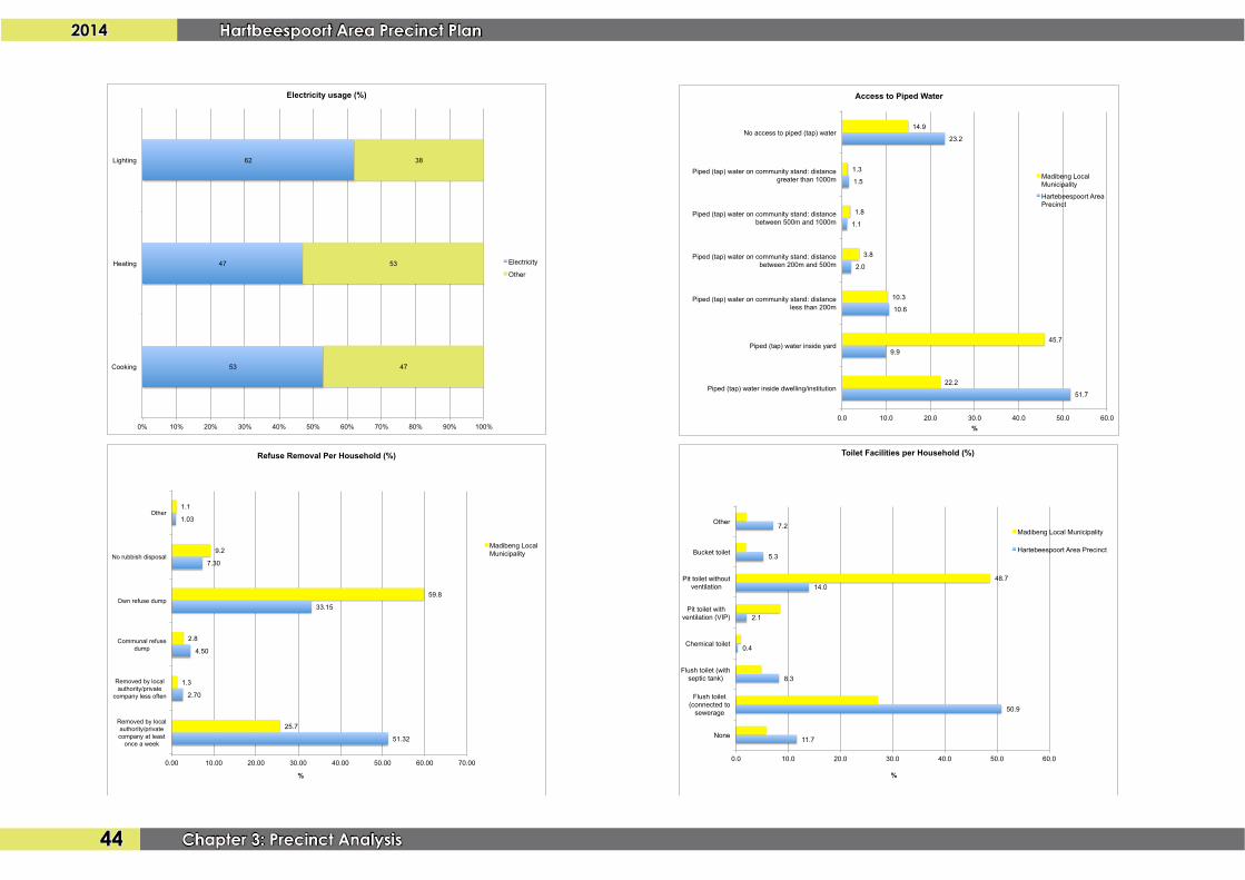
• 62%ofhouseholdsuseelectricityforlighting,47%forheatingand53%forcooking;
• 52%ofhouseholdshavepipedwaterinsidetheirdwelling(only22.2%forMLM),withafurther10%withpipedwaterinsidetheiryard.23%ofhouse-holdshavenoaccesstopipedwater;
• 51%ofhouseholdshaveaccesstowaterbornesewerage(only27.2%inMLM)whileafurther8%haveaflushtoiletwithseptictank.12%ofhouseholdshavenoaccesstosanitationasopposedtoonly5.8%inthewholeofMLM;and
• 51%ofhouseholdsreceiveweaklyrefuseremovalservices(only25.7%inMLM)while33%utilisetheirownrefusedumps.7%ofhouseholdshavenoaccesstorefuseremovalservices.10
10 Source for Socio-Economic Profile: Statistics SA (Census 2011)
2014Hartbeespoort Area Precinct Plan
43Chapter 3: Precinct Analysis
67
9
2
22
45.3
19.8
3.6
31.3
0
10
20
30
40
50
60
70
80
Employed Unemployed Discouraged work-seeker
Other not economically active
%
Employment Status of People Between 15 and 64 Years (%)
Hartebeespoort Area Precinct
Madibeng Local Municipality
13.4
3.1 3.8
11.8
16.6
11.4
7.8
10.0
11.3
6.7
2.8
1.2
16.2
3.4
5.5
17.4
20.0 19.3
9.4
4.8
2.6
0.9 0.3 0.2
0.0
5.0
10.0
15.0
20.0
25.0
No income R 1 - R 4800 R 4801 - R 9600
R 9601 - R 19 600
R 19 601 - R 38 200
R 38 201 - R 76 400
R 76 401 - R 153 800
R 153 801 - R 307 600
R 307 601 - R 614 400
R 614 001 - R 1 228 800
R 1 228 801 - R 2 457 600
R 2 457 601 or more
%
Annual Household Income (%)
Hartebeespoort Area Precinct
Madibeng Local Municipality
54.2
0.9
1.5
3.2
1.4
0.4
2.5
7.8
26.9
0.6
0.1
0.6
51.7
0.7
1.3
0.5
0.3
0.9
2.8
9.4
30.0
1.7
0.1
0.6
0.0 10.0 20.0 30.0 40.0 50.0 60.0
Single Dwelling House
Traditional dwelling
Flat or apartment in a block of flats
Cluster house in complex
Townhouse
Semi-detached house
House/flat/room in backyard
Informal dwelling in backyard
Informal dwelling not in backyard
Room/flatlet on a property
Caravan/tent
Other
%
Housing Typologies
Madibeng Local Municipality
Hartebeespoort Area Precinct
36.1
20.1 19.8 21.9
2.1
28.6
4.7
15.1
49.4
2.2
0.0
10.0
20.0
30.0
40.0
50.0
60.0
Rented Owned but not yet paid off
Occupied rent-free
Owned and fully paid off
Other
%
Ownership Profile (%)
Hartebeespoort Area Precinct
2014 Hartbeespoort Area Precinct Plan
44 Chapter 3: Precinct Analysis
51.7
9.9
10.6
2.0
1.1
1.5
23.2
22.2
45.7
10.3
3.8
1.8
1.3
14.9
0.0 10.0 20.0 30.0 40.0 50.0 60.0
Piped (tap) water inside dwelling/institution
Piped (tap) water inside yard
Piped (tap) water on community stand: distance less than 200m
Piped (tap) water on community stand: distance between 200m and 500m
Piped (tap) water on community stand: distance between 500m and 1000m
Piped (tap) water on community stand: distance greater than 1000m
No access to piped (tap) water
%
Access to Piped Water
Madibeng Local Municipality
Hartebeespoort Area Precinct
11.7
50.9
8.3
0.4
2.1
14.0
5.3
7.2
48.7
0.0 10.0 20.0 30.0 40.0 50.0 60.0
None
Flush toilet (connected to
sewerage
Flush toilet (with septic tank)
Chemical toilet
Pit toilet with ventilation (VIP)
Pit toilet without ventilation
Bucket toilet
Other
%
Toilet Facilities per Household (%)
Madibeng Local Municipality
Hartebeespoort Area Precinct
51.32
2.70
4.50
33.15
7.30
1.03
25.7
1.3
2.8
59.8
9.2
1.1
0.00 10.00 20.00 30.00 40.00 50.00 60.00 70.00
Removed by local authority/private company at least
once a week
Removed by local authority/private
company less often
Communal refuse dump
Own refuse dump
No rubbish disposal
Other
%
Refuse Removal Per Household (%)
Madibeng Local Municipality
53
47
62
47
53
38
0% 10% 20% 30% 40% 50% 60% 70% 80% 90% 100%
Cooking
Heating
Lighting
Electricity usage (%)
Electricity
Other
2014Hartbeespoort Area Precinct Plan
45Chapter 3: Precinct Analysis
284284284284284284284284284498498498498498498498498498
971971971971971971971971971187187187187187187187187187
346634663466346634663466346634663466
528528528528528528528528528
705705705705705705705705705
606060606060606060
777777777777777777
108108108108108108108108108172117211721172117211721172117211721
534953495349534953495349534953495349
362536253625362536253625362536253625
283283283283283283283283283
131813181318131813181318131813181318
247247247247247247247247247
162016201620162016201620162016201620
257825782578257825782578257825782578103103103103103103103103103
132913291329132913291329132913291329
195419541954195419541954195419541954
168316831683168316831683168316831683
Magaliesberg Nature ReserveMagaliesberg Nature ReserveMagaliesberg Nature ReserveMagaliesberg Nature ReserveMagaliesberg Nature ReserveMagaliesberg Nature ReserveMagaliesberg Nature ReserveMagaliesberg Nature ReserveMagaliesberg Nature Reserve
Rietfontein AHRietfontein AHRietfontein AHRietfontein AHRietfontein AHRietfontein AHRietfontein AHRietfontein AHRietfontein AH
Melodie AHMelodie AHMelodie AHMelodie AHMelodie AHMelodie AHMelodie AHMelodie AHMelodie AH
SchoemansvilleSchoemansvilleSchoemansvilleSchoemansvilleSchoemansvilleSchoemansvilleSchoemansvilleSchoemansvilleSchoemansville
MelodieMelodieMelodieMelodieMelodieMelodieMelodieMelodieMelodie
Hartebeespoort SPHartebeespoort SPHartebeespoort SPHartebeespoort SPHartebeespoort SPHartebeespoort SPHartebeespoort SPHartebeespoort SPHartebeespoort SP Kosmos BKosmos BKosmos BKosmos BKosmos BKosmos BKosmos BKosmos BKosmos B
Kosmos RidgeKosmos RidgeKosmos RidgeKosmos RidgeKosmos RidgeKosmos RidgeKosmos RidgeKosmos RidgeKosmos Ridge
IfafiIfafiIfafiIfafiIfafiIfafiIfafiIfafiIfafi Xanadu Eco ParkXanadu Eco ParkXanadu Eco ParkXanadu Eco ParkXanadu Eco ParkXanadu Eco ParkXanadu Eco ParkXanadu Eco ParkXanadu Eco Park
Port d` AfriquePort d` AfriquePort d` AfriquePort d` AfriquePort d` AfriquePort d` AfriquePort d` AfriquePort d` AfriquePort d` Afrique
Kosmos AKosmos AKosmos AKosmos AKosmos AKosmos AKosmos AKosmos AKosmos A
The CovesThe CovesThe CovesThe CovesThe CovesThe CovesThe CovesThe CovesThe Coves
De Rust WesDe Rust WesDe Rust WesDe Rust WesDe Rust WesDe Rust WesDe Rust WesDe Rust WesDe Rust Wes
The Island EstateThe Island EstateThe Island EstateThe Island EstateThe Island EstateThe Island EstateThe Island EstateThe Island EstateThe Island Estate
Luciana EstatesLuciana EstatesLuciana EstatesLuciana EstatesLuciana EstatesLuciana EstatesLuciana EstatesLuciana EstatesLuciana Estates
Pelindaba IndustrialPelindaba IndustrialPelindaba IndustrialPelindaba IndustrialPelindaba IndustrialPelindaba IndustrialPelindaba IndustrialPelindaba IndustrialPelindaba Industrial
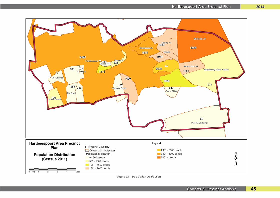
Hartbeespoort Area PrecinctPlan
0 0.5 1 2 3 4 5 km
NPopulation Distribution(Census 2011)
Legend
Precinct Boundary
Census 2011 Subplaces
Population Distribution
0 - 500 people
501 - 1000 people
1001 - 1500 people
1501 - 2000 people
2001 - 3000 people
3001 - 5000 people
5001+ people
Figure 18: Population Distribution
2014 Hartbeespoort Area Precinct Plan
46 Chapter 3: Precinct Analysis
R514R514R514R514R514R514R514R514R514
R511R511R511R511R511R511R511R511R511
R511R511R511R511R511R511R511R511R511
R511R511R511R511R511R511R511R511R511
R560R560R560R560R560R560R560R560R560
R512R512R512R512R512R512R512R512R512
R512R512R512R512R512R512R512R512R512
R512R512R512R512R512R512R512R512R512
R560R560R560R560R560R560R560R560R560
R104R104R104R104R104R104R104R104R104
R560R560R560R560R560R560R560R560R560
R104R104R104R104R104R104R104R104R104
R512R512R512R512R512R512R512R512R512
N4
VOORTREKKER GRAVESVOORTREKKER GRAVESVOORTREKKER GRAVESVOORTREKKER GRAVESVOORTREKKER GRAVESVOORTREKKER GRAVESVOORTREKKER GRAVESVOORTREKKER GRAVESVOORTREKKER GRAVES
EUGENE MARAISEUGENE MARAISEUGENE MARAISEUGENE MARAISEUGENE MARAISEUGENE MARAISEUGENE MARAISEUGENE MARAISEUGENE MARAIS
GEN. H. SCHOEMANGEN. H. SCHOEMANGEN. H. SCHOEMANGEN. H. SCHOEMANGEN. H. SCHOEMANGEN. H. SCHOEMANGEN. H. SCHOEMANGEN. H. SCHOEMANGEN. H. SCHOEMAN
WAR GRAVESWAR GRAVESWAR GRAVESWAR GRAVESWAR GRAVESWAR GRAVESWAR GRAVESWAR GRAVESWAR GRAVES
ARCHAELOGICAL SITEARCHAELOGICAL SITEARCHAELOGICAL SITEARCHAELOGICAL SITEARCHAELOGICAL SITEARCHAELOGICAL SITEARCHAELOGICAL SITEARCHAELOGICAL SITEARCHAELOGICAL SITE
HIGH ARCHEOLOGICAL VALUE - MAGALIESBERGHIGH ARCHEOLOGICAL VALUE - MAGALIESBERGHIGH ARCHEOLOGICAL VALUE - MAGALIESBERGHIGH ARCHEOLOGICAL VALUE - MAGALIESBERGHIGH ARCHEOLOGICAL VALUE - MAGALIESBERGHIGH ARCHEOLOGICAL VALUE - MAGALIESBERGHIGH ARCHEOLOGICAL VALUE - MAGALIESBERGHIGH ARCHEOLOGICAL VALUE - MAGALIESBERGHIGH ARCHEOLOGICAL VALUE - MAGALIESBERG
ARCHAEOLOGICAL SITEARCHAEOLOGICAL SITEARCHAEOLOGICAL SITEARCHAEOLOGICAL SITEARCHAEOLOGICAL SITEARCHAEOLOGICAL SITEARCHAEOLOGICAL SITEARCHAEOLOGICAL SITEARCHAEOLOGICAL SITE
Xanadu Eco ParkXanadu Eco Park
Lakeland EstateLakeland Estate
NECSANECSA
SunwaySunway
KosmosKosmos
SchoemansvilleSchoemansville
West Lake EstateWest Lake Estate
Heron CoveHeron Cove
Leloko EstateLeloko Estate
Magalies Golf Estate and River ClubMagalies Golf Estate and River Club
Caribbean BeachCaribbean Beach
The Island EstateThe Island Estate
MelodieMelodie
Melodie AHMelodie AH
Ville D'AfricqueVille D'Africque
PecanwoodPecanwood
IfafiIfafi
MeerhofMeerhof
N4N4N4N4N4N4N4N4N4
XanaduXanaduXanaduXanaduXanaduXanaduXanaduXanaduXanadu
DamsigDamsigDamsigDamsigDamsigDamsigDamsigDamsigDamsig
Hartbeespoort Area PrecinctPlan
0 0.5 1 2 3 4 5 km
NHeritage
Legend
Precinct Boundary
Heritage
Townships
Ridges
Places, Neighbourhoods and Estates
Roads and Transportation
National Roads
National Roads
Regional Roads
Regional Roads
Main Roads
Railway Line
Stations
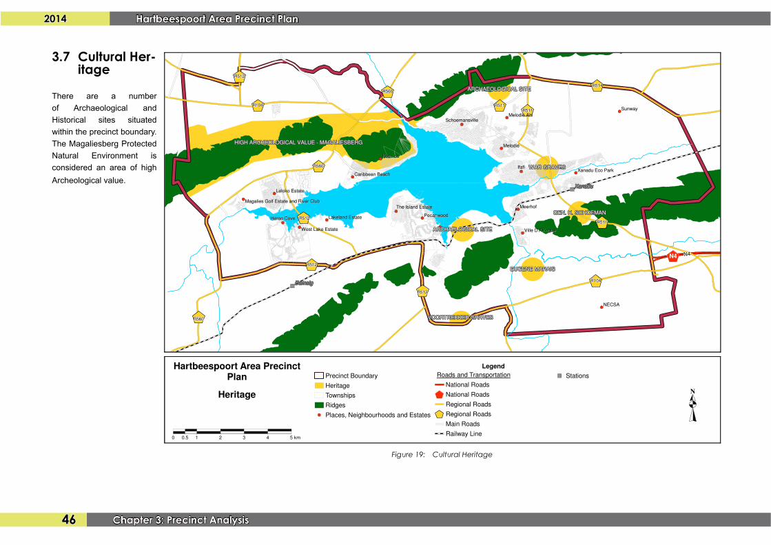
Figure 19: Cultural Heritage
3.7 Cultural Her-itage
There are a numberof Archaeological andHistorical sites situated withintheprecinctboundary.TheMagaliesbergProtectedNatural Environment isconsidered an area of high Archeologicalvalue.
Chapter 4:Issues

2014 Hartbeespoort Area Precinct Plan
48 Chapter 4: Issues
Chapter 4: Issues
4.1 SWOT Analysis
Thischaptersetsoutalltheissuesthathavebeenidentifiedaspartofthesituationalanalysisorhavebeenidentifiedbyvariousstakeholders.ThenumbersrefertonumbersonFigure20.
4.1.1 Strengths and Opportunities
• Theareacomprisesanumberoftourismattractionandfacilitiesthatcanbeimprovedthrough:
• theapplicationofplanningprinciplessuchasclustering,linkagesandintegration;
• improvedlandusemanagementtoensureefficiencyandabettersenseofplace;
• thecreationofsmallerspecialdevelopmentzones(e.g.ScottStreet,Damdoryn,SunwayVillagearea,VillageMallandSedibaareas)
• TheMadibengSpatialDevelopmentFramework,2009hasidentifiedtheareaasafutureurbandevelopmentarea.
• TheR511betweenSaartjiesnekalongtheroutetowardsSedibaPlaza,theVillageMallandultimatelytheDamdorynAreaprovidesanopportunityfortheestablishmentofabusinessandtourismcorridor.Properplanninganddevel-opmentcontrolsshouldbedeterminedtoenhancethedevelopmentofandalong this corridor. 1
• Therailwayline,althoughvandalisedandnotoperational,providesanop-portunityfromatourismperspectiveandforcommutertransportationbetweenTshwaneandtheMagaliesburg/CradleofHumankindareas. 2
• TheestablishmentofaPublic-PrivatePartnershiptomanagepubliclandaroundthedam.
• Thedevelopmentofacyclingroutealongthedamfortourismandasameansof transportation.
• TheRietfonteinarea,althoughsubjecttoanumberoftownshipapplications,stillprovidesanopportunityfortheestablishmentofintegratedsettlements.Thisrequiresgoodplanning,inparticularroadsmasterplanningaccordingtowhichlandusesshouldbestructured.
• TheareatothesouthoftheHartiesCablewayprovidesanopportunityforthedevelopmentofanurbanvillagewithastrongfocusontourism. 4
4.1.2 Weaknesses and Threats
• Illegaldevelopmentsandlandusesareprolificinthearea,anddevelopers/ownersarealsonotprosecutedforthesedevelopments.Theseillegaldevel-opmentshavefar-reachingconsequencesinboththeshortandlongterm,including:
• Thesafetyofdevelopmentsfromastructural,fireandtrafficsafetyperspective;
• Thevisualqualityofdevelopmentandthedegreetowhichtheseillegaldevelopmentsdetractfromthequality(orpotentialquality)ofthearea;
• Thelackoffunctionalintegrationbetweendifferentdevelopments,andbetweendevelopmentsandthemovementnetwork;
3

2014Hartbeespoort Area Precinct Plan
49Chapter 4: Issues
• Thepotentialnegativeenvironmentalimpactofillegaldevelopmentsthatdidnotgothroughenvironmentalimpactprocesses;and
• AlossofrevenueforMadibengLocalMunicipalitybecausethemunici-palvaluesofthesedevelopmentsarenotadjusted(aswouldbethecasewithlegaldevelopments).
• TheinstitutionalchallengesthatMadibengLocalMunicipalityhavetomanagedevelopmentfromanenvironmental,spatial,landuse,urbandesignandbuild-ing control perspective.
• SandquarriesintheWitwatersbergwhichthreatenfaunaandflorainthemountain. 5
• Generalhaphazarddevelopmentpatterns.
• Thelargenumberofsmallerfarmportions/agriculturalholdingsinthelargerRi-etfonteinareawhichposeachallengetotheholisticdevelopmentofthisareaasanintegratedsettlement.
• TheprivatisationoftheshorelineandthereducedabilityofthegeneralpublictoaccessthedamforrecreationpurposesisanissuethathasbeenraisedintheMadibengSpatialDevelopmentFramework,2009andisstillamainconcernamongststakeholders.Landcurrentlystillavailableforpublicaccessalongthedam(i.e.KommandonekandOberon)shouldbeprotectedfromdevelopment. 7
• ThethreattoenvironmentalsustainabilityandtheprotectionofnaturalassetssuchastheMagaliesbergProtectedNaturalEnvironmentandfaunasuchasvulturesduetoongoingdevelopment. 8
• Lackofpropershorelinemanagementbyresidentialestatesaroundthedam.9
6
• Theinformalsettlements,livingconditionsoffarmworkersandtheneedforaffordablehousingopportunitiestoaccommodatepeoplewithouthousing. 10
• Lackofadequateengineeringservicestosupportfuturedevelopment.
• Regionalroadswhichareinabadconditionanddangerous. 11
• Alackofsufficienteducationfacilities(inparticularasecondaryschool)thatareopentothegeneralpublic(i.e.notprivateschools).
• Theneedforsustainableemploymentopportunities,includingLocalEconomicDevelopmentfocusingonlocalresidents.AparticularaspectthatrequiresattentionistheconditionsattheAfricanMarket,whichwasintendedtobeacommunity-basedeconomicdevelopmentproject. 12
• ThelackoffunctionalintegrationandcooperationbetweentheHartbeespoortDamareaandtheCityofTshwane.
4.2 Issues
• Moreclarityshouldbegivenregardingdevelopmentdensities(includingmini-mumsubdivisionstandards).ThecurrentdevelopmentcontrolsforZone5and7intheMadibengSDF2009allowforsubdivisionupto5ha.Thisshouldhow-everbereviewedtopermitthesmallersubdivisionoflandsubjecttospecificdevelopmentcontrolsaswellasaroadsmasterplanforthearea.
• The5kmdevelopmentrestrictionaroundNECSAiscontroversialandshouldbereviewedbasedonthehealthandenvironmentalrisksposedbythecurrentandfutureuseofNECSA. 13
2014 Hartbeespoort Area Precinct Plan
50 Chapter 4: Issues
• TheK16designofinterchangesdidnottakesufficientcognizanceofexistingservitudes in Rietfontein.
• Theprotectionofimportantviewsandvistasfromthemountainrangesoverthedamandthesurroundinglandscape. 15
• TheclassificationoftheR511throughthedevelopedareaofHartbeespoortshouldberevisited.Thecurrentdevelopments(legalandillegal)andfuturedevelopmentneedsalongthisrouteemphasizethefactthethispartoftheroute,atleast,shouldbede-classifiedtoalowerclasstoallowformoreregu-laraccessintervalsthaniscurrentlythecase.ThispartoftherouteshouldalsobetakenoverbyeithertheDistrictCouncilortheMunicipalityastheirresponsibility. 16
• Aproper“RoadsandStormWaterDrainageMasterPlan”,“ElectricityMasterPlan”,“SewerMasterPlan”,and“WaterMasterPlan”shouldbedraftedfortheprecinctarea.Theseplansshouldaddressthecurrentcapacityvs.thesparecapacityvs.thecapacitythatisneededoverthelongertermtoaddresstheanticipateddevelopmentsaccordingtotheproposedprecinctplan.
14

2014Hartbeespoort Area Precinct Plan
51Chapter 4: Issues
Figure 20: Issues

Chapter 5:Precinct Plan

2014 Hartbeespoort Area Precinct Plan
54 Chapter 5: Precinct Plan
Chapter 5: Precinct Plan
5.1 Development Objectives
TheobjectivesforthefuturedevelopmentoftheHartbeespoortDamareaare:
• Afocussedandwell-plannedapproachtodevelopmentandinfrastructureinvestmentthatallowsforthecreationofsustainableneighbourhoodsthatareattractive,safeandconvenientplacesforpeopletolivein;
• Thefacilitationofappropriateeconomicdevelopment;
• Theintegrationofdifferentpartsoftheprecinctinternallyandwithotherpartsoftheregionthroughefficientandaffordablemovementssystems;and
• Theprotectionandenhancementofenvironmentallysensitiveareas.
5.2 Development Principles
Thespecificvaluesandprinciples that form thebasisof theHartbeespoortPrecinctPlanaresetoutbelow:
Protection of the Environment and Capitalising on Environmental Assets
TheHartbeespoortAreaarerichlyendowedwithanumberofenvironmentallysensitiveareasthatcontributetothedevelopmentappealoftheareaandalsoformthebasisofthetourismpotentialthatisinherenttothearea.Thesenaturalfeatures(suchasthemountainsanddam)infactprovidetheareawithacomparativedevelopmentadvantageintheregionandarevaluableassets,i.e.asessentialingredientsofaunique,attractive,interesting,recognisable,memorable,healthy,liveableandsustainablehumanhabitat.
Becauseofdevelopmentpressureinthearea,theseenvironmentallysensitiveareasare constantly under threat, and the visual and ecological integrity of these placesshouldbeprotectedasafirstpriority.This isobviously important fromanecological
andenvironmentalsustainabilityperspective,butalsotoensurethatthearearetainsistourismvalueanduniquesellingpoints.
Creation of Integrated and Sustainable Human Settlements
Development patterns in the study area (with the exception of the ‘old’ residentialneighbourhoods around the dam) have taken the form of fragmented, introvertedresidentialestatesthathaveeachbeendevelopedinisolationofeachotherandwithnorelationshiptoalargerdevelopmentandplanningvision.Non-residentialdevelopmenthassubsequentlyfollowedthesamedevelopmentpattern.Theresultisanareawithpoorconnectivity, linkagesandintegrationbetweendifferentdevelopments,andverylittleopportunitylefttocreateanefficienturbanstructure,inparticularinsofaritrelatestotheplanninganddevelopmentofcommunityclustersthatcontainsocialandcommunitysupport facilities.
Thefuturefocusofthedevelopmentinthearea(inparticularthelargerRietfonteinarea)shouldthereforebeonthecreationofawell-structuredbuiltenvironmentthatallowsforfunctionalmovementpatternsandthedevelopmentofnon-residentialactivitiesthatcansupporttheresidentsofthearea.ThemainchallengeinthisregardisthelargenumberofsmallerfarmportionsintheRietfonteinandMelodieAHareaswhicharethemaincontributingfactortothefragmenteddevelopmentpatternsinthisarea.
Development Supportive of Public Transport, Pedestrians and Cyclists
Themovementnetworkinthearea(inparticularmorelocalsectionsofthatnetwork)shouldbeplannedanddesignedtoaccommodatepedestrians,publictransport,cyclingand other forms of non-motorised movement. The road systemmust still allow forsmoothflowofvehiculartraffic,butthisshouldnotbetheonlyortheprimaryobjectiveofthelayout.Thisisnecessaryto-
• ensurethatthosewhocannotorchoosenottodrive(primarilythepoor,youth,elderlyandtourists)areabletomovethroughtheareaandaccessallfacilities

2014Hartbeespoort Area Precinct Plan
55Chapter 5: Precinct Plan
andopportunitieseasily,safelyandindependently;
• enableandstimulatesocialinteractioninpublic;and
• createhealthierenvironmentsandstimulatehealthierlifestyles.
Accommodate a Variety of Lifestyles, Life Stages and Income Groups
Thegeneralperceptionoftheareafromasocialperspectiveisthatithasbeendesignedanddevelopedtoaccommodatepeoplefromhigher incomegroups inestates,whilelower income groups who work in the area are mainly accommodated in informalsettlements.Thereisthereforeacleardistinctionbetweentheaccommodation,servicesandopportunitiesthatareavailabletodifferentsocio-economicgroups.
Inordertorectifythis,theareashouldbedevelopedasaneconomicallyandsociallyintegrated community that does not exclude any group. This means that it shouldaccommodatepeoplefromallincomeandagegroupsanddifferentfamilystructures.In order to ensure socially integrated communities, the area should embody andincorporatethefollowingaspects:
• equitableanduniversallyaffordableaccesstofacilitiesandopportunities;
• genuinelypublicplaceswheresocialinteractionandintegrationarepossible;
• arangeofhousingopportunities,typologiesandenvironments,includingaf-fordablehousingclosetoemploymentandpublictransportopportunities;and
• supportingservicessuchaspublictransport,health,education,recreation,entertainment,shoppingandotheressentialfacilitiesandservices.
5.3 Spatial Development Concept and Strategies
TheSpatialDevelopmentConceptfortheHartbeespoortAreafocusesonthecreationofdistinctenvironmentswithspecificcharacteristicsandfunctionswhicharemutuallysupportiveofeachother.Cleardistinctionshouldbemadebetweenenvironmentsthatareintendedforrurallivingand/oragriculture,residentialdevelopmentandmixed-useactivity.FutureinvestmentandmanagementbytheMadibengLocalMunicipalityshouldfocusonestablishingandsupportingthesedevelopmentmorphologies.
Seven(7)main interventionsorstrategiesformthebasisof thespatialdevelopmentconcept,namely:
1. Theprotectionofsensitiveenvironments;
2. Thecreationofselectedhigherordernodalareasthatwillensureabalanceddistributionofnon-residentialactivitiesthroughouttheprecinctandwillalsoactaskeystructuringelements,namely-
• TheconsolidatedoftheDamdorynNode;
• Theconsolidationofnon-residentialactivitiestothesouthofthePecan-woodEstatewhichincludethebothexisting,approvedandproposedbusinessdevelopmentssuchastheMountainLakeShoppingCen-tre,theproposedTheBayshoppingcentreandbusiness,education,recreationalandleisuredevelopmentsincludedaspartofthe‘Masada’development;
• Thecreationofamixed-useactivitycorridoralongtheR511intheeast-ernpartofthestudyarea;
3. TheestablishmentofaruraltourismareaalongtheR104inthenorth-westernpartoftheprecinctwhichisaimedateconomicdevelopmentwhileprotectingtheenvironmentalcapitalofthisarea;
4. ThedevelopmentofthecorridortothesouthofNECSAasalightindustrial/commercialarea;
5. ThedevelopmentoftheMelodieAgriculturalHoldingsareaasamixed-use,urbanenvironmentthatisdistinctlydifferentfromtheinward-orientedresiden-tialdevelopmentpatternsthatarecharacteristicoftheareatotheeastthereof.Thecoreofthisdevelopmentareawillbeatourism-relateddevelopmentspinerunningfromthecablewaydowntoVillageMallandontotheSchoemansvilleNatureConservationArea;
6. ThecreationofasustainablehumansettlementintheRietfonteinareathat

2014 Hartbeespoort Area Precinct Plan
56 Chapter 5: Precinct Plan
Figure 21: Spatial Development Concept and Strategies