The Nile floodplain Farming in the Nile floodplain Felucca boats.

Page 1 of 20
LLoouuiissvviillllee MMeettrroo
Multi-Hazards Mitigation Plan 2014 Annual CRS Floodplain Progress Report
The Disaster Mitigation Act of 2000 required local communities to address natural hazards in
their community with a focus on “pre-disaster mitigation” rather than “post-disaster responses.”
The Louisville Metro Multi-Hazards Mitigation Plan 2011 was developed by Louisville Metro
Emergency Management Agency (EMA), the Louisville Metropolitan Sewer District (MSD),
and the Louisville and Jefferson County Information Consortium (LOJIC) to meet this
requirement, as well as the Community Rating System (CRS) requirement for a Floodplain
Management Plan.
The CRS Floodplain Management Plan is required to be updated annually. This memo
represents that annual progress report and will be distributed to the media and made available to
the public through MSD’s website at www.msdlouky.org and EMA’s website at
www.louisvilleky.gov/EMA. Copies of the progress report will also be sent to the Mayor of
Louisville, Greg Fischer, the Louisville Metro Council, the LOJIC Policy Board, and the
Directors of EMA and MSD. In addition, a copy of the annual progress report will be available
to the public at MSD’s main office located at 700 West Liberty Street in Louisville, KY.
Background
The Multi-Hazards Mitigation Plan was completed in
2011 and was developed by a Plan Development
Team which comprised of Project Staff and an
Advisory Committee. Project Staff included
members from Louisville EMA, Louisville MSD,
and LOJIC, as well as consultants. The Advisory
Committee includes members from over 60 agencies
and organizations. These members represented
hazard-related agencies and organizations from local,
state, and federal agencies, as well as community
representatives, local business leaders, academia,
government, businesses, public health and hospitals,
neighborhoods, citizens, and volunteer/public service
organizations.
Thirteen hazards were identified within the Multi-Hazard Mitigation Plan, with flooding
considered the most severe hazard. The most common types of flooding within Louisville Metro
are flash floods and Ohio River flooding. Based on historic records, serious flooding from the
Ohio River has occurred in Louisville on average about once every 10 years and generally occurs
between the months of January and May. Louisville also has an extensive flash flooding

Louisville Metro Multi-Hazards Mitigation Plan 2014 Annual CRS Floodplain Progress Report
Page 2 of 20
problem. Louisville Metro has 11 major watersheds, which are susceptible to flash flooding any
time of the year due to heavy thunderstorms. The Pond Creek watershed has the largest number
of historical flood claims and the largest total amount of flood claims, with approximately
$2,000,000 in losses. The largest number of repetitive loss properties and severe repetitive loss
properties are located in the City/Ohio River watershed.
Mitigation Strategy
As part of the Multi-Hazard Mitigation Plan, a five-year Action Plan was created for each of the 13
hazards listed in the plan. The Advisory Committee met in three subcommittees to brainstorm a
draft Action Plan, consider cost/benefits, prioritize projects, and set an implementation timeline
and standard. During the work sessions, subcommittee members reviewed projects relevant to
their mitigation topics and focused on existing and future infrastructure.
From these general concerns and problems, Project Staff drafted a first cut at an Action Plan
which was submitted to the Advisory Committee for refinement at the next Advisory Committee
meeting. Some of the mitigation actions initially identified in the brainstorming sessions were
ultimately eliminated in the Action Plan due to existing programs and legislation or due to
limited capabilities, prohibitive costs, low benefit/cost ratio, or other concerns.
Once a draft Action Plan was created, the Plan Development Team analyzed the proposed
projects using FEMA’s Developing the Mitigation Plan (FEMA 386-3) that highlights the
STAPLEE method—a technique for identifying, evaluating, and prioritizing mitigation actions
based on existing local conditions.
To refine the Action Plan, an
analysis focused on several key
areas, such as, engineering,
technical, legal, environmental,
social, and political feasibility.
Using the STAPLEE criteria the
Plan Development Team weighed
the pros and cons of implementing
a particular mitigation action.
Through the prioritization table, a
cost-benefit analysis was completed
whereby, the higher the action’s
priority, the more cost beneficial
the action was determined to be for
the community. The Advisory
Committees used a scoring system
of: High, Medium, and Low. The
cost-benefit criteria used to
prioritize each action was:
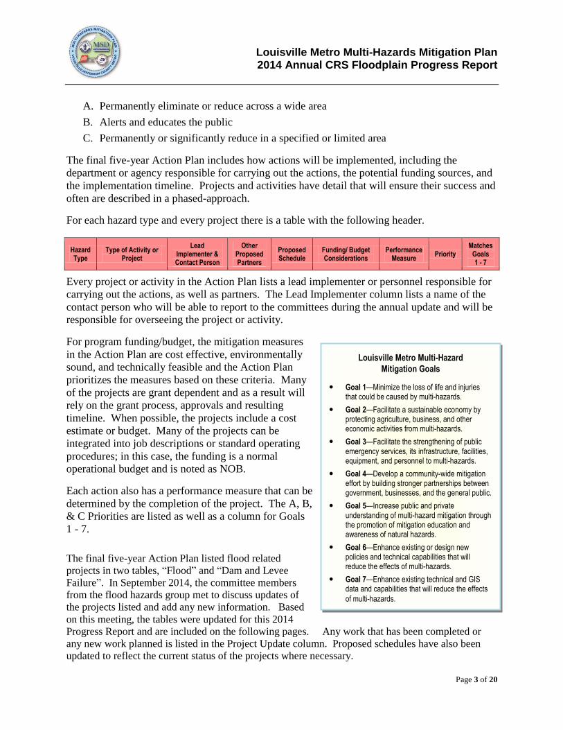
Priority Description of Mitigation
A
High
Permanently eliminate or reduce across a wide area
Priority A projects or activities permanently eliminate damages or have a high probability of systematically reducing damages or deaths and injuries across a wide area from one or more of Louisville Metro’s most significant hazards.
B
Medium
Alert and educate the public
Priority B projects, or activities, help alert the public to the approach of a threat from any of Louisville Metro’s hazards, or educate the public about the need for disaster preparedness and mitigation.
C
Low
Permanently or significantly reduce in a specified or limited area
Priority C projects, or activities, permanently or significantly reduce the probability of damages, deaths and injuries in a specified or limited area from one of Louisville Metro’s less significant hazards.
Louisville Metro Multi-Hazards Mitigation Plan 2014 Annual CRS Floodplain Progress Report
Page 3 of 20
A. Permanently eliminate or reduce across a wide area
B. Alerts and educates the public
C. Permanently or significantly reduce in a specified or limited area
The final five-year Action Plan includes how actions will be implemented, including the
department or agency responsible for carrying out the actions, the potential funding sources, and
the implementation timeline. Projects and activities have detail that will ensure their success and
often are described in a phased-approach.
For each hazard type and every project there is a table with the following header.
Hazard Type
Type of Activity or Project
Lead Implementer & Contact Person
Other Proposed Partners
Proposed Schedule
Funding/ Budget Considerations
Performance Measure
Priority Matches
Goals 1 - 7
Every project or activity in the Action Plan lists a lead implementer or personnel responsible for
carrying out the actions, as well as partners. The Lead Implementer column lists a name of the
contact person who will be able to report to the committees during the annual update and will be
responsible for overseeing the project or activity.
For program funding/budget, the mitigation measures
in the Action Plan are cost effective, environmentally
sound, and technically feasible and the Action Plan
prioritizes the measures based on these criteria. Many
of the projects are grant dependent and as a result will
rely on the grant process, approvals and resulting
timeline. When possible, the projects include a cost
estimate or budget. Many of the projects can be
integrated into job descriptions or standard operating
procedures; in this case, the funding is a normal
operational budget and is noted as NOB.
Each action also has a performance measure that can be
determined by the completion of the project. The A, B,
& C Priorities are listed as well as a column for Goals
1 - 7.
The final five-year Action Plan listed flood related
projects in two tables, “Flood” and “Dam and Levee
Failure”. In September 2014, the committee members
from the flood hazards group met to discuss updates of
the projects listed and add any new information. Based
on this meeting, the tables were updated for this 2014
Progress Report and are included on the following pages. Any work that has been completed or
any new work planned is listed in the Project Update column. Proposed schedules have also been
updated to reflect the current status of the projects where necessary.
Louisville Metro Multi-Hazard
Mitigation Goals
Goal 1—Minimize the loss of life and injuries that could be caused by multi-hazards.
Goal 2—Facilitate a sustainable economy by protecting agriculture, business, and other economic activities from multi-hazards.
Goal 3—Facilitate the strengthening of public emergency services, its infrastructure, facilities, equipment, and personnel to multi-hazards.
Goal 4—Develop a community-wide mitigation effort by building stronger partnerships between government, businesses, and the general public.
Goal 5—Increase public and private understanding of multi-hazard mitigation through the promotion of mitigation education and awareness of natural hazards.
Goal 6—Enhance existing or design new policies and technical capabilities that will reduce the effects of multi-hazards.
Goal 7—Enhance existing technical and GIS data and capabilities that will reduce the effects
of multi-hazards.

Page 4 of 20
22001111 FFLLOOOODD ((22001144 UUppddaattee))
FFiivvee--YYeeaarr AAccttiioonn PPllaann
Hazard Type of Activity or Project Lead Implementer & Contact Person
Other Proposed Partners
Proposed Schedule
Funding/ Budget Considerations
Performance Measure
Priority Matches
Goals 1 - 7
Project Update
1. Flood
Update Floodplain Ordinance
Particularly the enforcement section
Review criteria for enclosure limits
MSD – David Johnson
KDOW – NFIP Summer 2015 (revised from Dec 2011)
NOB Passage by Metro Council
C 1 & 6 MSD Engineering and Legal departments are currently making changes to the ordinance. Once revisions are complete, the ordinance will be presented to stakeholders and then Metro Council.
2. Flood
Flood Studies for Mitigation
Funding from MSD’s general fund and joint actions at MSD and private development community (e.g. St Mary & Eliz)
MSD – David Johnson
Private Development Community
Corps of Engineers
JHSMH
FY 2015 NOB New studies
LOMRs
Etc…
B 1, 2 & 4 Study of Bluegrass Avenue culvert has been completed. Culvert is in final stages of design and construction has been budgeted for FY15. Stream relocation is currently under construction.
3. Flood
Critical Facilities Analysis
Analyze if facilities lie in unmapped FEMA floodplain areas that might unknowingly be at risk
Develop list for mitigation
MSD GIS services – Julie Buckler
Louisville Metro Services
2014 (revised from
2011)
NOB Mitigation Studies
C 1 & 3 MSD GIS is in the process of creating preliminary maps for review.
Page 5 of 20
Hazard Type of Activity or Project Lead Implementer & Contact Person
Other Proposed Partners
Proposed Schedule
Funding/ Budget Considerations
Performance Measure
Priority Matches
Goals 1 - 7
Project Update
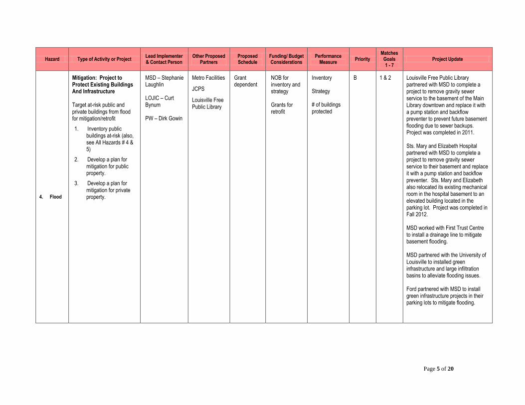
4. Flood
Mitigation: Project to Protect Existing Buildings And Infrastructure
Target at-risk public and private buildings from flood for mitigation/retrofit
1. Inventory public buildings at-risk (also, see All Hazards # 4 & 5)
2. Develop a plan for mitigation for public property.
3. Develop a plan for mitigation for private property.
MSD – Stephanie Laughlin
LOJIC – Curt Bynum
PW – Dirk Gowin
Metro Facilities
JCPS
Louisville Free Public Library
Grant dependent
NOB for inventory and strategy
Grants for retrofit
Inventory
Strategy
# of buildings protected
B 1 & 2 Louisville Free Public Library partnered with MSD to complete a project to remove gravity sewer service to the basement of the Main Library downtown and replace it with a pump station and backflow preventer to prevent future basement flooding due to sewer backups. Project was completed in 2011.
Sts. Mary and Elizabeth Hospital partnered with MSD to complete a project to remove gravity sewer service to their basement and replace it with a pump station and backflow preventer. Sts. Mary and Elizabeth also relocated its existing mechanical room in the hospital basement to an elevated building located in the parking lot. Project was completed in Fall 2012.
MSD worked with First Trust Centre to install a drainage line to mitigate basement flooding.
MSD partnered with the University of Louisville to installed green infrastructure and large infiltration basins to alleviate flooding issues.
Ford partnered with MSD to install green infrastructure projects in their parking lots to mitigate flooding.

Page 6 of 20
Hazard Type of Activity or Project Lead Implementer & Contact Person
Other Proposed Partners
Proposed Schedule
Funding/ Budget Considerations
Performance Measure
Priority Matches
Goals 1 - 7
Project Update
5. Flood
Risk Assessment: Develop a Flood Risk Assessment with Best Available Data
Collect Building first floor elevations
Use data to model at-risk structures
Cost could be significant depending on the # of elevations
Corps of Engineers data should be reviewed
List all agencies with data or sources and research various locations and types of data.
* FEMA grant awarded, project to begin 2011/12
LOJIC - Curt Bynum
EMA - Jim McKinney
MSD – Julie Buckler
Corps of Engineers
FEMA
FEMA grant awarded, project to begin 2011/2012
Grants Completed elevations
B 1& 7 Grant received to survey first floor elevations for 300 homes. First floor elevations were completed in 2012.

Page 7 of 20
Hazard Type of Activity or Project Lead Implementer & Contact Person
Other Proposed Partners
Proposed Schedule
Funding/ Budget Considerations
Performance Measure
Priority Matches
Goals 1 - 7
Project Update
6. Flood
Future Floodplain Buyouts Throughout The County
Identify repetitive loss candidates, specifically properties in the floodway
Prepare grant application Letter of Intent (LOI) and grant application process
MSD – Lori Rafferty/ Stephanie Laughlin
EMA
KyEM
Grant dependent
Grants Acquisition of properties
A 1 & 2
Grant to acquire 12802 Seatonville Road has been approved. Property has been acquired and structure is awaiting relocation.
In 2013, three grants were submitted for 15 structures in the Hayfield/Dundee and Elba Drive areas. One severe repetitive loss property was approved for the next step in the FEMA review process.
Seven grants were submitted in 2014 for the Transylvania Beach, Bartley Drive, and Medford Lane areas.
Countywide Flood Mitigation Prioritization Project is underway to identify areas with most severe flooding and determine future grant proposals. Project scheduled to be completed by the end of 2014.
7. Flood
Acquisitions in Western Louisville CSSA Area
See list of potential areas at the end of the Flood section
MSD – Stephanie Laughlin
EMA
KyEM
Grant dependent
Grants Acquisition of properties
A 1 & 2 HMGP grant received to purchase 128 homes in the Maple Street area within the combined sewer area (CSSA) in Western Louisville. As of July 2014, 61 properties have been acquired and 32 have been demolished.
Four additional grants have been submitted to acquire additional homes in the floodprone area via PDM and HMGP grants.

Page 8 of 20
Hazard Type of Activity or Project Lead Implementer & Contact Person
Other Proposed Partners
Proposed Schedule
Funding/ Budget Considerations
Performance Measure
Priority Matches
Goals 1 - 7
Project Update
8. Flood
Permanent Signage On The Parkway Areas
Warning people that they are entering a floodprone area
Determine strategy and funding
MSD – Tony Marconi
PW - Tim Maier
Metro Parks
KYTC
2015 -develop strategy (revised from 2011)
NOB or grant Installation of signs
B 1 & 5 Project is in progress.
9. Flood
Parking Signs For Existing Floodprone Areas
Coordinate with MSD and Public Works
Warning people that they are parking in a floodprone area
Determine strategy and funding
MSD – Tony Marconi
PW - Tim Maier
Metro Parks
Private business
2015 -develop strategy (revised from 2011)
NOB Installation of signs
B 1 & 5 No action has currently been taken on this project.
10. Flood
Place Flood Elevation Markers Along At-Risk Roads
Especially roads that are frequently overtopped to demonstrate to drivers/pedestrians how deep the water is
Complete an inventory of current sign locations
Develop strategy for other at-risk areas
Post signs
MSD – Kevin Bright
PW - Tim Maier
NWS
Metro Parks
KYTC
Suburban Cities
2011 -develop strategy
NOB Installation of signs
B 1 & 5 MSD has placed 74 signs at 32 viaducts throughout the county warning of high water.

Page 9 of 20
Hazard Type of Activity or Project Lead Implementer & Contact Person
Other Proposed Partners
Proposed Schedule
Funding/ Budget Considerations
Performance Measure
Priority Matches
Goals 1 - 7
Project Update
11. Flood
Flood Control Projects
Metro Parks is contemplating flood water retention projects in cooperation with MSD. E.g. Iroquois Park
Metro Parks – Jason Canuel
Corps of Engineers
MSD
LOPC
Grant dependent
Grant Construction of improvement
A 1 & 2 Iroquois Park project was completed in 2011.
12. Flood
Mill Creek Study Project
1. Ongoing Corp of Engineers study
2. Construction
Water Resources
Development Act (WRDA)
MSD – Brad
Selch
Corp of Engineers
1. 2014 (revised from 2011), Complete study
Federal Grant (WRDA) dependent
Completion of study and construction of project
A 1 & 2 Corps of Engineers study is complete. Old Mill Creek floodgate will be removed and the old levee will be opened up to improve drainage. Pump station will also be removed, along with several other gates that are no longer in use. Project will be bid by the end of 2014.
13. Flood
Aluma Basin –
MSD is in the design stage for a flood control basin near the confluence of Northern and Southern Ditch. This basin will be constructed on 50 acres of property recently purchased by MSD.
o Basin will be located between Northern Ditch and the Scottsdale and Confederate Acres subdivisions.
o Basin could provide an additional 300 acre/feet of floodplain storage in this low-lying area.
MSD – Greg Powell
None identified 2014 NOB
Regional Facility Fee (partly)
Grant
Construction of basin
A 1 & 2 Project is complete.
14. Flood
LaClede Basin – Proposed
flood control basin
located near end of W. Indian
Trail and Greasy Ditch
MSD – Greg Powell
None identified Grant dependent
Grant Construction of basin
A 1 & 2 Grant approved to purchase one property adjacent to basin.
Basin is on hold until funding is available.
Page 10 of 20
Hazard Type of Activity or Project Lead Implementer & Contact Person
Other Proposed Partners
Proposed Schedule
Funding/ Budget Considerations
Performance Measure
Priority Matches
Goals 1 - 7
Project Update
15. Flood
Tin Dor Way Basin -
proposed flood control basin
in Fairdale near Tin Dor Way
If flood control basin is not
feasible, then develop
strategy for possible buyouts
MSD – Greg Powell
None identified Grant dependent
Grant Construction of basin
A 1 & 2 Project is on hold until funding is available.
16. Flood
Bluegrass Avenue Box Culvert – remove the ‘reverse’ invert (remove siltation) and possibly add a second barrel at this intersection.
Part 1 – Maintenance of existing
Part 2 – Identify and implement other improvements
MSD
Part 1, Tony Marconi
Part 2, Greg Powell
PW
Corps of Engineers
JHSMH
1. June 2011
2. Grant dependent
$300,000 estimate
NOB
Grant
Construction of improvement
A 1, 2 & 3 Maintenance was completed by MSD September 2012.
Study has been completed. Phase 1 of the project to relocate a portion of the stream is currently underway. Phase 2 of the project to install an additional parallel culvert under Bluegrass Avenue is estimated to be under construction in 2015.
17. Flood
Lift station at Churchman Avenue
Separate stormwater system into hospital
Eliminate gravity basement service
Develop strategy and estimate
Sts Mary & Elizabeth – Steve French
MSD 2012 NOB
Grant
Insurance
Construction of station
A 2 & 3 Construction will be completed for this project Fall 2012.
Page 11 of 20
Hazard Type of Activity or Project Lead Implementer & Contact Person
Other Proposed Partners
Proposed Schedule
Funding/ Budget Considerations
Performance Measure
Priority Matches
Goals 1 - 7
Project Update
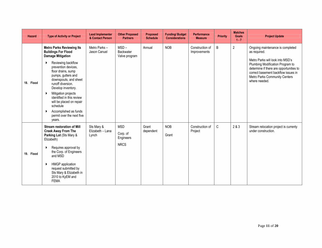
18. Flood
Metro Parks Reviewing Its Buildings For Flood Damage Mitigation
Reviewing backflow prevention devices, floor drains, sump pumps, gutters and downspouts, and sheet runoff diversion. Develop inventory.
Mitigation projects identified in this review will be placed on repair schedule
Accomplished as funds permit over the next five years.
Metro Parks – Jason Canuel
MSD – Backwater Valve program
Annual NOB Construction of Improvements
B 2 Ongoing maintenance is completed as required.
Metro Parks will look into MSD’s Plumbing Modification Program to determine if there are opportunities to correct basement backflow issues in Metro Parks Community Centers where needed.
19. Flood
Stream restoration of Mill Creek Away From The Parking Lot (Sts Mary & Elizabeth)
Requires approval by the Corp. of Engineers and MSD
HMGP application request submitted by Sts Mary & Elizabeth in 2010 to KyEM and FEMA
Sts Mary & Elizabeth – Lana Lynch
MSD
Corp. of Engineers
NRCS
Grant dependent
NOB
Grant
Construction of Project
C 2 & 3 Stream relocation project is currenty under construction.

Page 12 of 20
Hazard Type of Activity or Project Lead Implementer & Contact Person
Other Proposed Partners
Proposed Schedule
Funding/ Budget Considerations
Performance Measure
Priority Matches
Goals 1 - 7
Project Update
20. Flood
Establish and Coordinate Tree Programs And Partnerships To Increase Tree Canopy, Parkway Areas
Metro Parks and MSD are expanding the tree canopy in the metropolitan area. Part of the plant 10,000 trees campaign.
Partner with PDS to increase canopy on parkway areas
Metro Parks will continue over the next five years to replace trees along parkways and in landscaped park areas as needed to retain tree canopy cover in the metropolitan area.
Metro Parks – Jason Canuel
MSD – Wes Sydnor
PDS Five-years NOB # of trees planted
C 4 MSD’s goal is to plant 1,000 trees annually, with a commitment to plant 14,000 by 2024. Grant funding has been awarded to plant close to 7,000 trees currently.
MSD has partnered with Metro for the Urban Tree Canopy Assessment. Based on factors such as open space, heat island effect, sewer issues, flooding and runoff, recommendations from the assessment will be made to determine which areas should be targeted for increased tree canopy. The assessment is scheduled to be completed in 2015.
21. Flood
Public Outreach about Basement Flooding
Education of the public from keeping critical items out of basements – computers, books, important files etc.….
Target the audience on regulatory floodplain or MSD customer service requests rather than just the FEMA floodplains
MSD – Lori Rafferty
MSD - Sheryl Lauter
Media
Louisville Free Public Library
June 2011 NOB Published info B 5 Advertisements have been run in Louisville Magazine and Business First regarding ways to reduce basement backups.
Letters were mailed to floodplain and repetitive loss properties that included information regarding MSD’s plumbing modification program to reduce basement backups.
Page 13 of 20
Hazard Type of Activity or Project Lead Implementer & Contact Person
Other Proposed Partners
Proposed Schedule
Funding/ Budget Considerations
Performance Measure
Priority Matches
Goals 1 - 7
Project Update
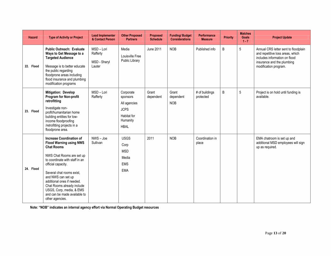
22. Flood
Public Outreach: Evaluate Ways to Get Message to a Targeted Audience
Message is to better educate the public regarding floodprone areas including flood insurance and plumbing modification programs
MSD – Lori Rafferty
MSD - Sheryl Lauter
Media
Louisville Free Public Library
June 2011 NOB Published info B 5 Annual CRS letter sent to floodplain and repetitive loss areas, which includes information on flood insurance and the plumbing modification program.
23. Flood
Mitigation: Develop Program for Non-profit retrofitting
Investigate non-profit/humanitarian home building entities for low-income floodproofing /retrofitting projects in a floodprone area.
MSD – Lori Rafferty
Corporate sponsors
All agencies
JCPS
Habitat for Humanity
HBAL
Grant dependent
Grant dependent
NOB
# of buildings protected
B 5 Project is on hold until funding is available.
24. Flood
Increase Coordination of Flood Warning using NWS Chat Rooms
NWS Chat Rooms are set up to coordinate with staff in an official capacity.
Several chat rooms exist, and NWS can set up additional ones if needed. Chat Rooms already include USGS, Corp, media, & EMS and can be made available to other agencies.
NWS – Joe Sullivan
USGS
Corp
MSD
Media
EMS
EMA
2011 NOB Coordination in place
EMA chatroom is set up and additional MSD employees will sign up as required.
Note: “NOB” indicates an internal agency effort via Normal Operating Budget resources

Page 14 of 20
22001111 DDAAMM AANNDD LLEEVVEEEE FFAAIILLUURREE ((22001144 UUppddaattee))
FFiivvee--YYeeaarr AAccttiioonn PPllaann
Hazard Type of Activity or Project Lead
Implementer & Contact Person
Other Proposed Partners
Proposed Schedule
Funding/ Budget
Considerations
Performance Measure
Priority Matches
Goals 1 - 7
Project Update
1. Dam & Levee Failure
Risk Assessment: Develop A Dam & Levee Risk Assessment With Best Available Data
PHASE 1: Verify GIS locations for existing dams.
Develop data inventory of all dams within Louisville Metro area. Steps:
Collect data from KDOW for locations and assessment of the State-Owned dams.
Perform research in the State Dam Safety Program records, which requires an “Open Records” request to the KDOW.
Research records and locations of dams within metro boundaries.
From research, collect other important data, e.g. current EAPs, dam materials, past inspections, violations, etc…
Collect inventory of dam locations and geo-code.
Verify which Class C dams have an EAP.
* FEMA grant submitted in December 2010 by Metro
MSD - Tony Marconi
LOJIC -Curt Bynum
KDOW Dam Safety Program, Marilyn Thomas
NRCS
Metro/Suburban Fire Districts
Metro Parks
Grant dependent
FEMA grant submitted in December 2010
GIS locations and inventory database
B 1,2,& 7 EAPs for each of the 10 high hazard dams will be completed by the end of 2014.
Page 15 of 20
Hazard Type of Activity or Project Lead
Implementer & Contact Person
Other Proposed Partners
Proposed Schedule
Funding/ Budget
Considerations
Performance Measure
Priority Matches
Goals 1 - 7
Project Update
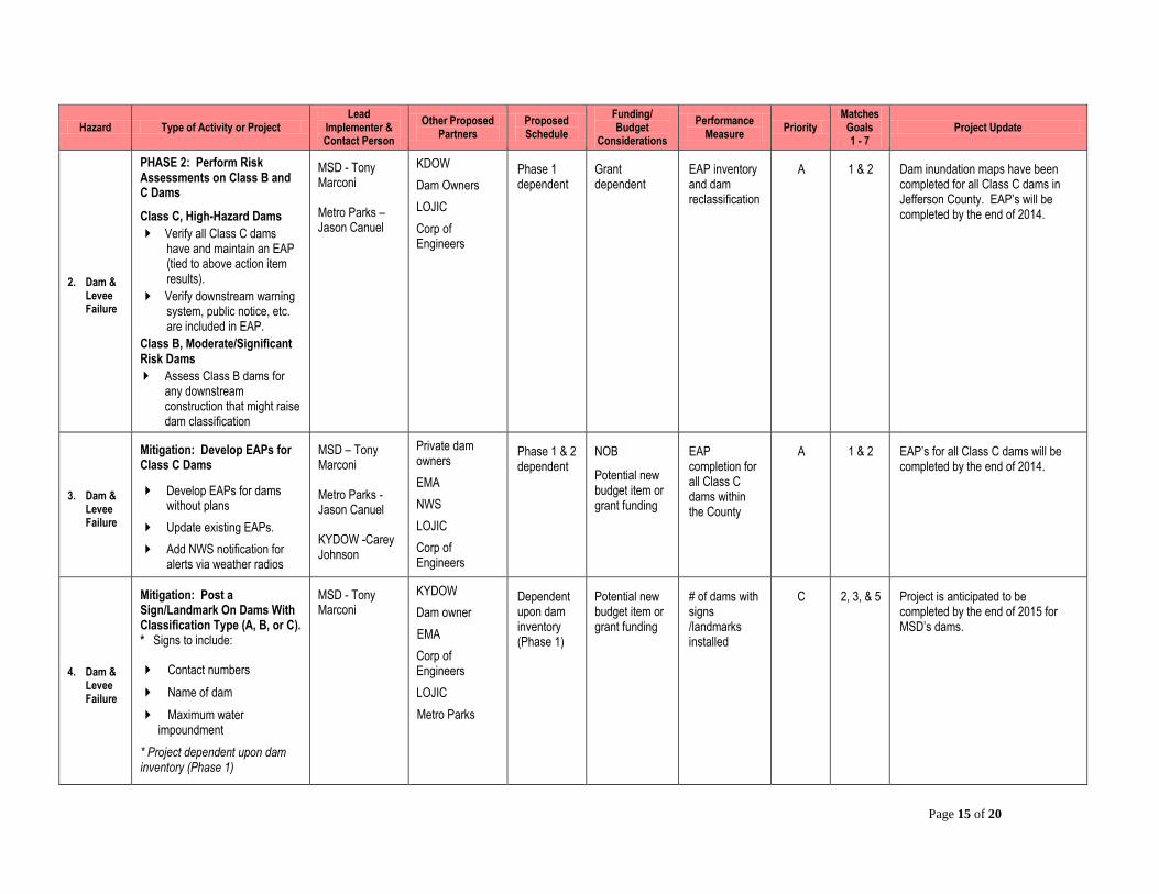
2. Dam & Levee Failure
PHASE 2: Perform Risk Assessments on Class B and C Dams
Class C, High-Hazard Dams
Verify all Class C dams have and maintain an EAP (tied to above action item results).
Verify downstream warning system, public notice, etc. are included in EAP.
Class B, Moderate/Significant Risk Dams
Assess Class B dams for any downstream construction that might raise dam classification
MSD - Tony Marconi
Metro Parks – Jason Canuel
KDOW
Dam Owners
LOJIC
Corp of Engineers
Phase 1 dependent
Grant dependent
EAP inventory and dam reclassification
A 1 & 2 Dam inundation maps have been completed for all Class C dams in Jefferson County. EAP’s will be completed by the end of 2014.
3. Dam & Levee Failure
Mitigation: Develop EAPs for Class C Dams
Develop EAPs for dams without plans
Update existing EAPs.
Add NWS notification for alerts via weather radios
MSD – Tony Marconi
Metro Parks - Jason Canuel
KYDOW -Carey Johnson
Private dam owners
EMA
NWS
LOJIC
Corp of Engineers
Phase 1 & 2 dependent
NOB
Potential new budget item or grant funding
EAP completion for all Class C dams within the County
A 1 & 2 EAP’s for all Class C dams will be completed by the end of 2014.
4. Dam & Levee Failure
Mitigation: Post a Sign/Landmark On Dams With Classification Type (A, B, or C). * Signs to include:
Contact numbers
Name of dam
Maximum water impoundment
* Project dependent upon dam inventory (Phase 1)
MSD - Tony Marconi
KYDOW
Dam owner
EMA
Corp of Engineers
LOJIC
Metro Parks
Dependent upon dam inventory (Phase 1)
Potential new budget item or grant funding
# of dams with signs /landmarks installed
C 2, 3, & 5 Project is anticipated to be completed by the end of 2015 for MSD’s dams.

Page 16 of 20
Hazard Type of Activity or Project Lead
Implementer & Contact Person
Other Proposed Partners
Proposed Schedule
Funding/ Budget
Considerations
Performance Measure
Priority Matches
Goals 1 - 7
Project Update
5. Dam & Levee Failure
Mitigation: Remove or Replace Unsafe Dams
Once inspections are complete, the list of unsafe dams will determine next steps for repair and/or removal of dams. An unsafe dam would move to a Priority A project for immediate action.
* Project dependent upon dam inventory and assessment (Phases 1 & 2)
KY DOW Dam Safety Program – Marilyn Thomas
NRCS
Dam owner
LOJIC
MSD
Metro Parks
Phase 1 & 2 dependent
Metro Parks
MSD Capital Projects
NRCS
# of dams removed or repaired
A 1, 2, & 3 No dams within Louisville Metro have been found to be unsafe.
6. Dam & Levee Failure
Risk Assessment: Develop a Dam & Levee Risk Assessment With Best Available Data
Develop Dam inundation models for Class C dams
Models will provide the at-risk locations of properties downstream, required warning times.
MSD – Tony Marconi
LOJIC - Curt Bynum
Corp of Engineers
KDOW
LOJIC
MSD
Phase 1 & 2 dependent
Potential new budget item or grant funding
Inundation Models and Mapping
B 1, 2, & 7 Inundation maps were completed in 2014.
7. Dam & Levee Failure
Risk Assessment and Mitigation
Place a benchmark or similar point on dams to determine if movement is occurring.
Benchmark placement should coincide with inspection and data development.
Metro Parks - Jason Canuel
MSD – Tony Marconi
KYDOW
Dam owner
EMA
Corp of Engineers
PDS
LOJIC
Phase 1 & 2 dependent
Potential new budget item or grant funding
# of dams with benchmarks and signs installed
B 2 & 3 Annual funds may be available through LOJIC to establish new benchmarks at the three high hazard dams owner by MSD.

Page 17 of 20
Hazard Type of Activity or Project Lead
Implementer & Contact Person
Other Proposed Partners
Proposed Schedule
Funding/ Budget
Considerations
Performance Measure
Priority Matches
Goals 1 - 7
Project Update
8. Dam & Levee Failure
Consider Requiring EAP for Class B Dams
Class B dams have at-risk structures below the levee, therefore should require an emergency plan.
Partner with KY DOW Dam Safety Program for requirements and regulations
KY DOW Dam Safety Program – Marilyn Thomas
MSD
Metro Parks
Dam owner
LOJIC
Phase 1 & 2 dependent
2015
NOB EAPs C 1 No action has currently been taken on this project.
9. Dam & Levee Failure
Mitigation: Evaluate Damage To Levee And Flood Protection System
Primarily Ohio River Flood Protection System and large pump stations (i.e. Beargrass Creek). Corps annual inspection is ongoing.
Five-year inspection is more detailed
MSD –Tony Marconi
Daren Thompson
Corps of Engineers
LG&E
Annual MSD funded; estimated at $2 million/yr., additional funds are project dependent
Grants
# of facilities evaluated and rehabilitated
A 1 Maintenance and rehabilitation is done on an ongoing basis and as needed. MSD performs bi-annual inspections and the Corps inspects annually. MSD also performs preventative maintenance on levee gates bi-annually. The Corps of Engineers is currently conducting a Levee System Evaluation that is scheduled to be completed in March 2015.
Page 18 of 20
Hazard Type of Activity or Project Lead
Implementer & Contact Person
Other Proposed Partners
Proposed Schedule
Funding/ Budget
Considerations
Performance Measure
Priority Matches
Goals 1 - 7
Project Update
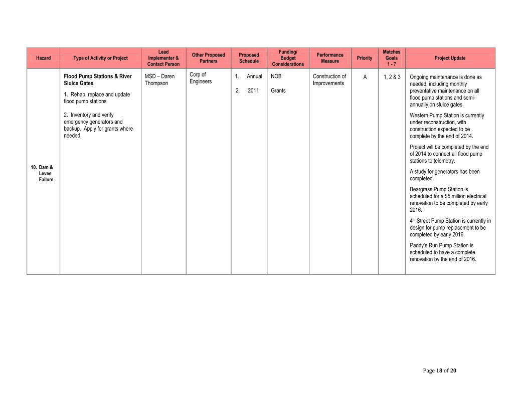
10. Dam & Levee Failure
Flood Pump Stations & River Sluice Gates
1. Rehab, replace and update flood pump stations
2. Inventory and verify emergency generators and backup. Apply for grants where needed.
MSD – Daren Thompson
Corp of Engineers
1. Annual
2. 2011
NOB
Grants
Construction of Improvements
A 1, 2 & 3 Ongoing maintenance is done as needed, including monthly preventative maintenance on all flood pump stations and semi-annually on sluice gates.
Western Pump Station is currently under reconstruction, with construction expected to be complete by the end of 2014.
Project will be completed by the end of 2014 to connect all flood pump stations to telemetry.
A study for generators has been completed.
Beargrass Pump Station is scheduled for a $5 million electrical renovation to be completed by early 2016.
4th Street Pump Station is currently in design for pump replacement to be completed by early 2016.
Paddy’s Run Pump Station is scheduled to have a complete renovation by the end of 2016.

Page 19 of 20
Hazard Type of Activity or Project Lead
Implementer & Contact Person
Other Proposed Partners
Proposed Schedule
Funding/ Budget
Considerations
Performance Measure
Priority Matches
Goals 1 - 7
Project Update
11. Dam
&
Levee
Failure
Mitigation: Develop Better Local Dam Construction And Inspections Criteria
In order of the following:
1. Develop inspection and construction criteria to review existing dams – adopt in Land Development Code
2. Begin periodic dam Inspection to develop reports. Metro Parks has a plan in place and performs regular inspections.
Metro Parks - Jason Canuel
MSD - Lori Rafferty
KYDOW
Dam owner
EMA
Corp of Engineers
PDS
2014 (revised from 2012)
Grants
NOB
- Inspection criteria and updated classifications
- Adopted in Land Development Code
A 2, 3, 4, & 7
No action has currently been taken to develop new construction criteria, but regular inspections continue to be completed as required.
12. Dam & Levee Failure
Mitigation: Develop A Local Dam Permitting Process
For dams that do not fit the state’s definition of a dam.
Adopt process in codes.
Metro Parks - Jason Canuel
MSD - David Johnson/Tony Marconi
KYDOW
EMA
PDS
IPL
2014 (revised from 2012)
Grants
NOB
- SOP Permit process
- Adopted in Land Development Code
C 1, 2, 3, 4 & 7
Design Manual updated to require EAPs if a new Class C dam is constructed.
13. Dam & Levee Failure
Metro Parks Remedial Work on their Dams
Remedial work needs to be competed on some dams
Maintenance and inspection needed
Coordinate with MSD
Metro Parks - Jason Canuel
MSD Grant dependent
NOB
Grant
Work completed
A 1 & 2 Ongoing maintenance is being completed as required.

Page 20 of 20
Hazard Type of Activity or Project Lead
Implementer & Contact Person
Other Proposed Partners
Proposed Schedule
Funding/ Budget
Considerations
Performance Measure
Priority Matches
Goals 1 - 7
Project Update
14. Dam & Levee Failure
Public Awareness
Through use of levees and dams for recreational purposes
Signage of the flood protection system history and assets
MSD - Tony Marconi
Corp of Engineers
KDOW
Metro Parks
2015 NOB Signs installed B 5 Levee trail signs installed by Metro Parks
15. Dam & Levee Failure
Ash Ponds – Haz-Mat
Ensure they are safe
LG& E – Keith Alexander
KDOW – Marilyn Thomas
EPA
Corp of Engineers
2011 NOB A 1 & 2 Dams have not been found to be unsafe.
Note: “NOB” indicates an internal agency effort via Normal Operating Budget resources