2012 Site Visit Report - Nunavummiut Makitagunarningit Site Visit Report 2 Meadowbank Gold Project...
30
2012 Site Visit Report for the NIRB’s Monitoring of Agnico-Eagle Mines Ltd.’s Meadowbank Gold Project Nunavut Impact Review Board November 2012
Transcript of 2012 Site Visit Report - Nunavummiut Makitagunarningit Site Visit Report 2 Meadowbank Gold Project...

2012 Site Visit Report
for the NIRB’s Monitoring of
Agnico-Eagle Mines Ltd.’s Meadowbank Gold Project
Nunavut Impact Review Board
November 2012

Nunavut Impact Review Board
2012 Site Visit Report ii Meadowbank Gold Project
Full Report Title: 2012 Site Visit Report for the Nunavut Impact Review Board’s
Monitoring of Agnico-Eagle Mines Ltd.’s Meadowbank Gold Project
(NIRB File No. 03MN107)
Project: Meadowbank Gold Project
Project Location: Kivalliq Region, Nunavut
Project Owner: Agnico-Eagle Meadowbank
PO Box 540
Baker Lake, NU
X0C 0A0
Proponent Contact: Kevin Buck, Environment Superintendent
Telephone: (819) 759-3555, ext. 6838
Visit conducted by: Sophia Granchinho, Technical Advisor and Monitoring Officer
Telephone: (866) 233-3033
Site visit dates: September 12-13, 2012
Last site visit: September 12-13, 2011
Report prepared by: Sophia Granchinho, Monitoring Officer
Photos by: Sophia Granchinho
Cover photos: 1) View of attenuation pond and central dike from stormwater dike
2) Processing plant
Nunavut Impact Review Board
2012 Site Visit Report iii Meadowbank Gold Project
TABLE OF CONTENTS
1 INTRODUCTION........................................................................................................................ 1
1.1 Objectives & Purpose of Site Visit .................................................................................. 1
1.2 Introduction of the Meadowbank Project ......................................................................... 1
1.3 Preparations for the Site Visit .......................................................................................... 2
2 SITE VISIT ............................................................................................................................... 2
2.1 General Observations ....................................................................................................... 3
2.2 Water Quality and Waste Management ......................................................................... 10
2.3 All-Weather Private Access Road (AWPAR) ................................................................ 17
2.4 Wildlife and Terrestrial .................................................................................................. 19
2.5 Noise............................................................................................................................... 20
2.6 Human Health ................................................................................................................ 21
2.7 Air Quality ...................................................................................................................... 21
2.8 Other ............................................................................................................................... 22
3 FINDINGS AND SUMMARY ..................................................................................................... 24
REFERENCES ................................................................................................................................. 26
LIST OF PHOTOGRAPHS
Photo 1: Willow Ptarmigan observed around the Meadowbank site .............................................. 3
Photo 2: Public user of the access road using safety vest and buggy whip installed – near
kilometre 50 ...................................................................................................................... 4
Photo 3: Contaminated soil storage/pilot remediation site ............................................................. 4
Photo 4: Quarry 5 in 2011 containing contaminated soil from fuel spill at kilometre 22 along the
access road ........................................................................................................................ 5
Photo 5: Quarry 5 in 2012 ............................................................................................................... 5
Photo 6: Quarry 22 serving as storage for contaminated soil ......................................................... 6
Photo 7: Environmental emergency sea-can near kilometre 22 ...................................................... 6
Photo 8: Environmental emergency sea-cans at the Baker Lake laydown facility ......................... 7
Photo 9: Portage Pit ........................................................................................................................ 7
Photo 10: Bay-Goose basin ............................................................................................................. 7
Photo 11: Water treatment facility .................................................................................................. 8
Photo 12: Tailings storage facility – north cell ............................................................................... 8
Photo 13: “Beach” tailings with Saddle Dam #1 in the background .............................................. 9
Photo 14: New kitchen facility ....................................................................................................... 9
Photo 15: Heavy equipment training simulator on site ................................................................. 10
Photo 16: Drilling of groundwater well, near Bay-Goose basin (photo taken September 2011) . 11
Photo 17: Waste Rock Facility ..................................................................................................... 12
Photo 18: Sea-cans used for waste segregation and storage area ................................................. 12
Photo 19: Dual chamber forced air incinerator at the Meadowbank site ...................................... 13
Photo 20: Open burning of non-hazardous wastes ....................................................................... 13
Photo 21: Bridge near kilometre 22 .............................................................................................. 14
Photo 22: Booms and screens in place at bridge near kilometre 22 ............................................. 15
Photo 23: Meadowbank on-site fuel tank farm ............................................................................. 15
Photo 24: Baker Lake bulk fuel storage facility ........................................................................... 16

Nunavut Impact Review Board
2012 Site Visit Report iv Meadowbank Gold Project
Photo 25: Baker Lake fuel transfer station ................................................................................... 16
Photo 26: Staining observed at the Meadowbank on-site fuel tank farm ..................................... 17
Photo 27: Gatehouse at kilometre 5, near Baker Lake .................................................................. 18
Photo 28: Signs posted at gatehouse at kilometre 5 ...................................................................... 19
Photo 29: Noise monitoring station #5 ......................................................................................... 20
Photo 30: Air monitoring stations ................................................................................................. 21
Photo 31: Vehicles on Meadowbank All-Weather Private Access Road ..................................... 22
Photo 32: Bake Lake dock and laydown facility .......................................................................... 23
Photo 33: Empty sea-cans awaiting transportation to the south via sealift ................................... 23

Nunavut Impact Review Board
2012 Site Visit Report 1 Meadowbank Gold Project
1 INTRODUCTION
The Nunavut Impact Review Board (NIRB or Board) was established through Article 12 of the
Nunavut Land Claims Agreement (NLCA) and is responsible for post environmental assessment
monitoring of a Project in accordance with Part 7 of Article 12 of the NLCA.
This report provides the findings that resulted from the site visit of the Meadowbank Gold
Project that took place on September 12 and September 13, 2012 as part of the NIRB’s
monitoring program.
1.1 Objectives & Purpose of Site Visit
In December 2006, pursuant to Section 12.5.12 of the NLCA, the NIRB issued Project
Certificate No. 004 for the Meadowbank Gold Project (the Project), allowing the Project to
proceed in accordance with the Terms and Conditions issued therein. In November 2009, the
NIRB formally amended the Project Certificate [No. 004] to include an amendment to Condition
32 pursuant to NLCA 12.8.2 and an approval to change the name of the holder of the Project
Certificate [No. 004] from Cumberland Resources Ltd. to Agnico-Eagle Mines Ltd. (NIRB,
2009).
The Board is responsible for the monitoring of this Project as per Sections 12.7.1 and 12.7.2 of
the NLCA. The objective of the NIRB’s site visit was to determine whether, and to what extent,
the land or resource use in question is being carried out within the predetermined terms and
conditions of the NIRB’s Meadowbank Gold Project Certificate [004] (Section 12.7.2(b) of the
NLCA).
The observations resulting from this site visit shall, wherever possible, be incorporated into the
measurement of the relevant effects of the project (Section 12.7.2(a), provide the information
necessary for agencies to enforce terms and conditions of land or resource use approvals (Section
12.7.2(c)), and will further be used to assess the accuracy of the predictions contained in the
project impact statements (Section 12.7.2(d)).
1.2 Introduction of the Meadowbank Project
The Project involves the construction and operation of an open pit gold mine located in the
Kivalliq Region of Nunavut, approximately 70 kilometres (km) north of the hamlet of Baker
Lake on Inuit-owned surface lands. The original Project proponent and owner, Cumberland
Resources Inc., estimated in 2006 that the Meadowbank project comprised of a total proven and
probable gold reserves of 2.7 million ounces, and that total construction and operating
expenditures would run at $304 million and $100 million per year, respectively (NIRB, 2006).
The current Project owner, Agnico Eagle Mines Limited (AEM or Proponent), indicated in its
December 2011 Reserves and Resources report that Meadowbank has proven and probable gold
reserves of 2.2 million ounces; lower than the initial value predicted (AEM, 2011). In February
2012, AEM issued a press release announcing that it was taking a write-down of $644.9 million
on the Meadowbank mine; due in part to a challenging operating year in 2011 including extreme
weather conditions, a fire at the Meadowbank site in March 2011 and the discovery of lower
gold grades than predicted (AEM, 2012). AEM has announced that its Meadowbank ore

Nunavut Impact Review Board
2012 Site Visit Report 2 Meadowbank Gold Project
reserves have been reduced as a result of it being unable to economically mine the lower grade
ore which has also reduced the life of the mine by approximately 3 years (AEM, 2012). AEM
provided a revised mine plan to the Kivalliq Inuit Association and has predicted that its
Meadowbank operations are now scheduled to be completed by 2017 instead of 2020 (AEM,
2012).
In addition to the mining infrastructure and activities, ancillary Project infrastructure is located
approximately 2 km east of the hamlet of Baker Lake and consists of barge unloading facilities, a
laydown storage and marshalling area, a 60 million litre (ML) fuel tank farm, associated
interconnecting roads and a 110 km all-weather private access road (access road) from the
hamlet of Baker Lake to the Meadowbank mine site. Supplies are shipped from other locations
within Canada via sealift to Baker Lake where they are offloaded at AEM’s marshalling area and
transported to the Meadowbank site via truck haul along the 110 km access road.
1.3 Preparations for the Site Visit
The Monitoring Officer reviewed the following items to prepare for the site visit: Meadowbank
Project Certificate [No. 004], 2011 Site Visit Report, AEM’s 2011 Annual Report and follow-up
correspondence from the NIRB’s 2011 site visit.
2 SITE VISIT
The 2012 site visit was conducted on September 12 and 13, 2012 by Sophia Granchinho, NIRB
Monitoring Officer. On Wednesday, September 12, 2012, the Monitoring Officer took the bus
from the AEM office in Baker Lake to the Meadowbank mine site. Once at the site, the
Monitoring Officer was met by Kevin Buck to discuss outstanding issues related to the Project
Certificate conditions and related to the 2011 site visit. In the afternoon, Mr. Buck and Charlene
Boutin-Racicot led a short tour of the site, which included the water treatment facility, pilot
remediation site, tailings storage facility and waste rock piles.
In the morning of September 13, 2012, the Monitoring Officer visited the waste and hazardous
materials storage area; incinerator; and the fuel storage area. Afterwards, the Monitoring Officer
accompanied AEM employees, Robin Allard and Ms. Boutin-Racicot to one of the noise
monitoring stations located near the Meadowbank exploration camp. Mid-morning, Ms. Boutin-
Racicot gave the Monitoring officer a tour of the following facilities: camp; water intake
(freshwater barge); air monitoring station; active mine areas including Portage pits and Bay-
Goose basin. At the conclusion of the site visit, the Monitoring Officer met with Mr. Buck to
discuss the site visit and further issues related to environmental compliance. Afterwards, Ms.
Boutin-Racicot drove the Monitoring Officer back to the hamlet of Baker Lake via the access
road and visited the following facilities: quarry 22, quarry 5, bridge at kilometre 22, the
gatehouse and with the visit ending with a tour of the Baker Lake bulk fuel storage
facility/marshalling area.
The site visit provided the Monitoring Officer with a tour of all major project components and
further, provided an opportunity for the Monitoring Officer and AEM staff to discuss relevant
issues related to the project.
Nunavut Impact Review Board
2012 Site Visit Report 3 Meadowbank Gold Project
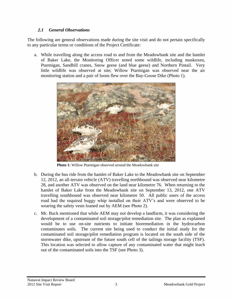
2.1 General Observations
The following are general observations made during the site visit and do not pertain specifically
to any particular terms or conditions of the Project Certificate:
a. While travelling along the access road to and from the Meadowbank site and the hamlet
of Baker Lake, the Monitoring Officer noted some wildlife, including muskoxen,
Ptarmigan, Sandhill cranes, Snow geese (and blue geese) and Northern Pintail. Very
little wildlife was observed at site; Willow Ptarmigan was observed near the air
monitoring station and a pair of loons flew over the Bay-Goose Dike (Photo 1).
Photo 1: Willow Ptarmigan observed around the Meadowbank site
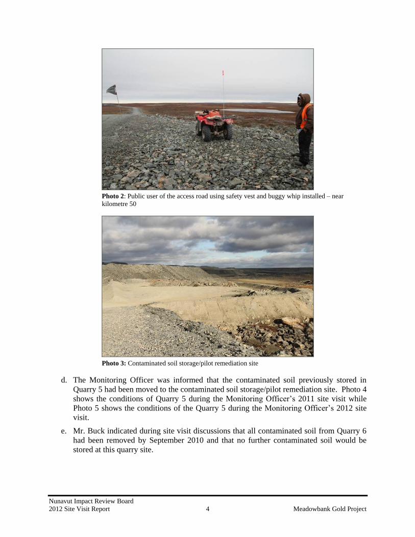
b. During the bus ride from the hamlet of Baker Lake to the Meadowbank site on September
12, 2012, an all-terrain vehicle (ATV) travelling northbound was observed near kilometre
28, and another ATV was observed on the land near kilometre 76. When returning to the
hamlet of Baker Lake from the Meadowbank site on September 13, 2012, one ATV
travelling southbound was observed near kilometre 50. All public users of the access
road had the required buggy whip installed on their ATV’s and were observed to be
wearing the safety vests loaned out by AEM (see Photo 2).
c. Mr. Buck mentioned that while AEM may not develop a landfarm, it was considering the
development of a contaminated soil storage/pilot remediation site. The plan as explained
would be to use on-site nutrients to initiate bioremediation in the hydrocarbon
contaminates soils. The current site being used to conduct the initial study for the
contaminated soil storage/pilot remediation program is located on the south side of the
stormwater dike, upstream of the future south cell of the tailings storage facility (TSF).
This location was selected to allow capture of any contaminated water that might leach
out of the contaminated soils into the TSF (see Photo 3).
Nunavut Impact Review Board
2012 Site Visit Report 4 Meadowbank Gold Project
Photo 2: Public user of the access road using safety vest and buggy whip installed – near
kilometre 50
Photo 3: Contaminated soil storage/pilot remediation site
d. The Monitoring Officer was informed that the contaminated soil previously stored in
Quarry 5 had been moved to the contaminated soil storage/pilot remediation site. Photo 4
shows the conditions of Quarry 5 during the Monitoring Officer’s 2011 site visit while
Photo 5 shows the conditions of the Quarry 5 during the Monitoring Officer’s 2012 site
visit.
e. Mr. Buck indicated during site visit discussions that all contaminated soil from Quarry 6
had been removed by September 2010 and that no further contaminated soil would be
stored at this quarry site.

Nunavut Impact Review Board
2012 Site Visit Report 5 Meadowbank Gold Project
Photo 4: Quarry 5 in 2011 containing contaminated soil from fuel spill at kilometre 22 along the
access road
Photo 5: Quarry 5 in 2012
f. Quarry 22 remains in service as a temporary land farm and storage area for contaminated
soils. AEM indicated that it plans to remove the contaminated soil to the pilot
remediation site in the near future. Currently, Quarry 22 is not being used to store other
material as had been the case in the past (see Photo 6).

Nunavut Impact Review Board
2012 Site Visit Report 6 Meadowbank Gold Project
Photo 6: Quarry 22 serving as storage for contaminated soil
g. The Monitoring Officer noted that the environmental emergency sea-cans containing
booms, shovels, absorbent pads, and other miscellaneous spill response equipment were
located at every bridge crossing. Further, two additional environmental emergency sea-
cans, one containing spill response equipment and another containing a boat with motor
were located at the Baker Lake laydown facility (see Photo 7 and Photo 8).
h. Active blasting and drilling were ongoing at the North, Central and South Portage pits,
with daily geotechnical inspections being undertaken to ensure the safety of all
employees and contractors working in the active mine area (see Photo 9).
i. Development of the Bay-Goose Dike and causeway was completed in 2010 with the
instrumentation on the Bay-Goose Dike and the jet grouting program completed in 2011.
Mining of the Bay-Goose basin started in May 2012. During the 2012 site visit, it was
noted that the Bay-Goose basin was still being dewatered (Photo 10). Water from the
Bay-Goose basin has been treated at the water treatment facility on an on-going basis
prior to discharge into the environment (Photo 11).
Photo 7: Environmental emergency sea-can near kilometre 22

Nunavut Impact Review Board
2012 Site Visit Report 7 Meadowbank Gold Project
Photo 8: Environmental emergency sea-cans at the Baker Lake laydown facility
Photo 9: Portage Pit
Photo 10: Bay-Goose basin
South pit Central pit North pit

Nunavut Impact Review Board
2012 Site Visit Report 8 Meadowbank Gold Project
Photo 11: Water treatment facility
j. By the end of 2011, approximately 4.07 million tonnes of tailings had been placed in the
TSF (Photo 12) since the start of the project. A structure known as the ‘reclaim barge’ is
used to re-circulate water from the TSF back to the mill for reuse within the processing
cycle (Photo 12). It was noted during the 2012 site visit that the TSF did not contain as
much water as was observed during the 2011 site visit. The diversion ditch north of the
TSF had been completed in the fall of 2011, preventing water from entering the TSF
during the freshet season, a situation that had occurred in 2011 prior to the completion of
the diversion ditch. As mentioned in the 2011 Site Visit Report, AEM noted that tailings
with a dryer consistency to the tailings deposited within the TSF provide something of a
“beach” in the TSF which helps to protect the dikes and to prevent ice formation (see
Photo 13). There did not appear to be any apparent rips to the liners that were exposed
within Saddle Dam #1 and Saddle Dam #2 (Photo 13).
Photo 12: Tailings storage facility – north cell
Reclaim
barge
Tailings
Waste
rock pile

Nunavut Impact Review Board
2012 Site Visit Report 9 Meadowbank Gold Project
Photo 13: “Beach” tailings with Saddle Dam #1 in the background
k. In March 2011, a fire at the Meadowbank mine destroyed the kitchen and dining
facilities, certain camp offices and the security office. By the end of 2011 the
construction of the new kitchen was completed, with the new facility becoming
operational on December 17, 2011 (see Photo 14).
Photo 14: New kitchen facility
l. AEM purchased a heavy equipment training simulator in 2011 which is used to train site
employees in the operation of a variety of heavy equipment (see Photo 15 ).
Liner at Saddle
Dam #1

Nunavut Impact Review Board
2012 Site Visit Report 10 Meadowbank Gold Project
Photo 15: Heavy equipment training simulator on site
Sections 2.2 through 2.8 relate to those sections of the Meadowbank Project Certificate as
indicated, with specific terms and conditions providing a basis for the noted observations.
2.2 Water Quality and Waste Management
Condition 8
“…At the time samples are taken Cumberland shall also assess the condition of existing
groundwater monitoring wells and replace any defective wells. Cumberland shall
continue to undertake semi-annual groundwater samples and re-evaluate the
groundwater quality after each sample collection…”
At the time of the site visit, only one groundwater monitoring well appeared to be operational.
AEM noted that the last operational groundwater monitoring well of those installed in 2003
became damaged from frost action in 2010. Three of the four defective wells were replaced in
2006 but were again damage by frost action. Two of the wells were again replaced in 2008 with
a more robust design. In 2011, two monitoring wells were installed, one on Goose Island to
replace one of the 2003 wells and one at the tailings storage facility to replace one of the 2007
wells. Only one of the wells replaced in 2008 was sampled in 2011 as the second well showed
blockage and no samples could be taken. Mr. Buck indicated that during the 2012 sampling
program, one well was damaged during movement of equipment on Goose Island and another
was damaged during sampling, leaving only one functional well. AEM indicated that it plans to
re-evaluate the groundwater monitoring program to determine how best to improve the
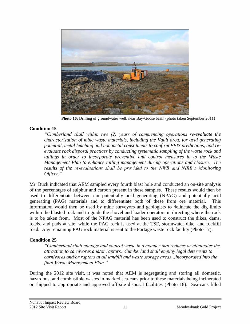
effectiveness of the wells and the collection of groundwater samples. Photo 16 provides an
example of development of a groundwater well near the Bay-Goose basin.
Nunavut Impact Review Board
2012 Site Visit Report 11 Meadowbank Gold Project
Photo 16: Drilling of groundwater well, near Bay-Goose basin (photo taken September 2011)
Condition 15
“Cumberland shall within two (2) years of commencing operations re-evaluate the
characterization of mine waste materials, including the Vault area, for acid generating
potential, metal leaching and non metal constituents to confirm FEIS predictions, and re-
evaluate rock disposal practices by conducting systematic sampling of the waste rock and
tailings in order to incorporate preventive and control measures in to the Waste
Management Plan to enhance tailing management during operations and closure. The
results of the re-evaluations shall be provided to the NWB and NIRB’s Monitoring
Officer.”
Mr. Buck indicated that AEM sampled every fourth blast hole and conducted an on-site analysis
of the percentages of sulphur and carbon present in these samples. These results would then be
used to differentiate between non-potentially acid generating (NPAG) and potentially acid
generating (PAG) materials and to differentiate both of these from ore material. This
information would then be used by mine surveyors and geologists to delineate the dig limits
within the blasted rock and to guide the shovel and loader operators in directing where the rock
is to be taken from. Most of the NPAG material has been used to construct the dikes, dams,
roads, and pads at site, while the PAG rock is used at the TSF, stormwater dike, and rockfill
road. Any remaining PAG rock material is sent to the Portage waste rock facility (Photo 17).
Condition 25
“Cumberland shall manage and control waste in a manner that reduces or eliminates the
attraction to carnivores and/or raptors. Cumberland shall employ legal deterrents to
carnivores and/or raptors at all landfill and waste storage areas…incorporated into the
final Waste Management Plan.”
During the 2012 site visit, it was noted that AEM is segregating and storing all domestic,
hazardous, and combustible wastes in marked sea-cans prior to these materials being incinerated
or shipped to appropriate and approved off-site disposal facilities (Photo 18). Sea-cans filled

Nunavut Impact Review Board
2012 Site Visit Report 12 Meadowbank Gold Project
with waste are backhauled via truck haul to Baker Lake and are then moved via the annual sea
lift to southern Canada.
Photo 17: Waste Rock Facility
Photo 18: Sea-cans used for waste segregation and storage area
The Meadowbank site dual chamber forced air incinerator remains in service for the combustion
of all non-hazardous, combustible materials at the site (Photo 19). Approximately 1.7 tonnes of
domestic garbage is incinerated per day; however, Mr. Buck indicated that there are plans in
place to improve waste management by reducing the amount of domestic garbage produced at
site. Some examples provided include replacing paper coffee cups with plastic coffee cups,
using plastic lunch boxes and trays instead of paper bags, recycling wood products by finding a
second use for it at site or taking it to Baker Lake where it could be used by community
members. It was also noted during the site visit that open burning was being conducted of some
of the non-hazardous wastes on site (Photo 20).

Nunavut Impact Review Board
2012 Site Visit Report 13 Meadowbank Gold Project
Photo 19: Dual chamber forced air incinerator at the Meadowbank site
Photo 20: Open burning of non-hazardous wastes
Mr. Buck indicated that fewer wildlife sightings had been observed around the site in 2012 since
the installation of deterrent by AEM. However, Mr. Buck indicated that six active falcon nests
had been observed within various quarry sites this year along the access road and one nest had
been observed within the Portage pit. Efforts to deter the falcons from returning to the nest in
the pit did not appear to work over the summer and AEM’s environment department monitored
the nest until the falcons left. Further, Mr. Buck indicated that a raven nest found at the Baker
Lake bulk fuel storage facility was removed by the Conservation Officer from Bake Lake. Mr.
Buck indicated that by the end of the summer season, it appeared that the adult falcon pair
Nunavut Impact Review Board
2012 Site Visit Report 14 Meadowbank Gold Project
nesting at the Portage pit had fledged one chick. Similarly, at the other nests within the quarry
sites, it appeared that the adult pairs had fledged successfully.
Condition 26
“Cumberland shall ensure that spills, if any, are cleaned up immediately and that the site
is kept clean of debris, including wind-blown debris.”
During the 2012 visit to the Meadowbank site, the Monitoring Officer noted that all areas were
kept in an impressively clean state, with no obvious spills. There were a few instances of wind-
blown material observed around the Meadowbank site.
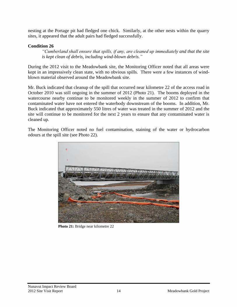
Mr. Buck indicated that cleanup of the spill that occurred near kilometre 22 of the access road in
October 2010 was still ongoing in the summer of 2012 (Photo 21). The booms deployed in the
watercourse nearby continue to be monitored weekly in the summer of 2012 to confirm that
contaminated water have not entered the waterbody downstream of the booms. In addition, Mr.
Buck indicated that approximately 550 litres of water was treated in the summer of 2012 and the
site will continue to be monitored for the next 2 years to ensure that any contaminated water is
cleaned up.
The Monitoring Officer noted no fuel contamination, staining of the water or hydrocarbon
odours at the spill site (see Photo 22).
Photo 21: Bridge near kilometre 22

Nunavut Impact Review Board
2012 Site Visit Report 15 Meadowbank Gold Project
Photo 22: Booms and screens in place at bridge near kilometre 22
Condition 27
“Cumberland shall ensure that the areas used to store fuel or hazardous materials are
contained using safe, environmentally protective methods based on practical, best
engineering practices.”
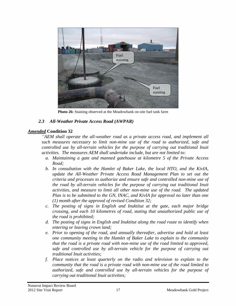
During the 2012 site visit, the Monitoring Officer observed that all of AEM’s fuel and hazardous
materials associated with the Meadowbank project appeared to be stored in a safe and
environmentally protective manner (i.e. secondary containment at fuel storage areas and secure
containment of hazardous materials; see Photo 23 and Photo 24).
Photo 23: Meadowbank on-site fuel tank farm
Nunavut Impact Review Board
2012 Site Visit Report 16 Meadowbank Gold Project
Photo 24: Baker Lake bulk fuel storage facility
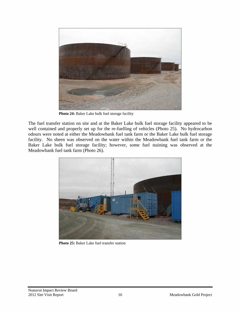
The fuel transfer station on site and at the Baker Lake bulk fuel storage facility appeared to be
well contained and properly set up for the re-fuelling of vehicles (Photo 25). No hydrocarbon
odours were noted at either the Meadowbank fuel tank farm or the Baker Lake bulk fuel storage
facility. No sheen was observed on the water within the Meadowbank fuel tank farm or the
Baker Lake bulk fuel storage facility; however, some fuel staining was observed at the
Meadowbank fuel tank farm (Photo 26).
Photo 25: Baker Lake fuel transfer station
Nunavut Impact Review Board
2012 Site Visit Report 17 Meadowbank Gold Project
Photo 26: Staining observed at the Meadowbank on-site fuel tank farm
2.3 All-Weather Private Access Road (AWPAR)
Amended Condition 32
“AEM shall operate the all-weather road as a private access road, and implement all
such measures necessary to limit non-mine use of the road to authorized, safe and
controlled use by all-terrain vehicles for the purpose of carrying out traditional Inuit
activities. The measures AEM shall undertake include, but are not limited to:
a. Maintaining a gate and manned gatehouse at kilometre 5 of the Private Access
Road;
b. In consultation with the Hamlet of Baker Lake, the local HTO, and the KivIA,
update the All-Weather Private Access Road Management Plan to set out the
criteria and processes to authorize and ensure safe and controlled non-mine use of
the road by all-terrain vehicles for the purpose of carrying out traditional Inuit
activities, and measure to limit all other non-mine use of the road. The updated
Plan is to be submitted to the GN, INAC, and KivIA for approval no later than one
(1) month after the approval of revised Condition 32;
c. The posting of signs in English and Inuktitut at the gate, each major bridge
crossing, and each 10 kilometres of road, stating that unauthorized public use of
the road is prohibited;
d. The posting of signs in English and Inuktitut along the road route to identify when
entering or leaving crown land;
e. Prior to opening of the road, and annually thereafter, advertise and hold at least
one community meeting in the Hamlet of Baker Lake to explain to the community
that the road is a private road with non-mine use of the road limited to approved,
safe and controlled use by all-terrain vehicle for the purpose of carrying out
traditional Inuit activities;
f. Place notices at least quarterly on the radio and television to explain to the
community that the road is a private road with non-mine use of the road limited to
authorized, safe and controlled use by all-terrain vehicles for the purpose of
carrying out traditional Inuit activities;
Fuel
staining
Fuel
staining

Nunavut Impact Review Board
2012 Site Visit Report 18 Meadowbank Gold Project
g. Record all authorized non-mine use of the road, and require all mine personnel
using the road to monitor and report unauthorized non-mine use of the road, and
collect and report this data to NIRB one (1) year after the road is opened and
annually thereafter; and
h. Report all accidents or other safety incidents on the road, to the GN, KivIA, and the
Hamlet immediately and to NIRB annually.”
AEM maintains one gatehouse at kilometre 5 of the access road, and another gatehouse close to
the entrance to the mine site and camp at Meadowbank. Both gatehouses are manned by guards
who monitor the safety and security of all personnel using the road. All traffic is required to
check in (via radio or in person) with the employee at the gatehouse prior to proceeding past
either gatehouse along the road (see Photo 27). The AEM employee manning the kilometre 5
gatehouse maintains a daily logbook of all persons travelling the access road for non-mine use.
Members of the public travelling along the road are required to sign AEM’s All Weather Private
Access Road Safety Rules & Procedures for Road Access prior to being granted access to the
road.
The Monitoring Officer reviewed the sign-in sheet at the gatehouse and noted that approximately
215 community members had signed in to use the road between September 1st and September
13th
. The employee at the gatehouse also indicated that the road is most commonly used by
community members on Saturdays.
Photo 27: Gatehouse at kilometre 5, near Baker Lake
As per Condition 32(b), AEM submitted a copy of its updated Transportation Management Plan
to the NIRB on May 13, 2010. One of the features of the access road as described within the
plan is the placement of refuge stations every 10 kilometres. The Monitoring Officer noted that
these refuge stations (emergency sea-cans) were not located on the road and was informed by
Mr. Buck that the sea-cans were removed because items within the stations were being stolen
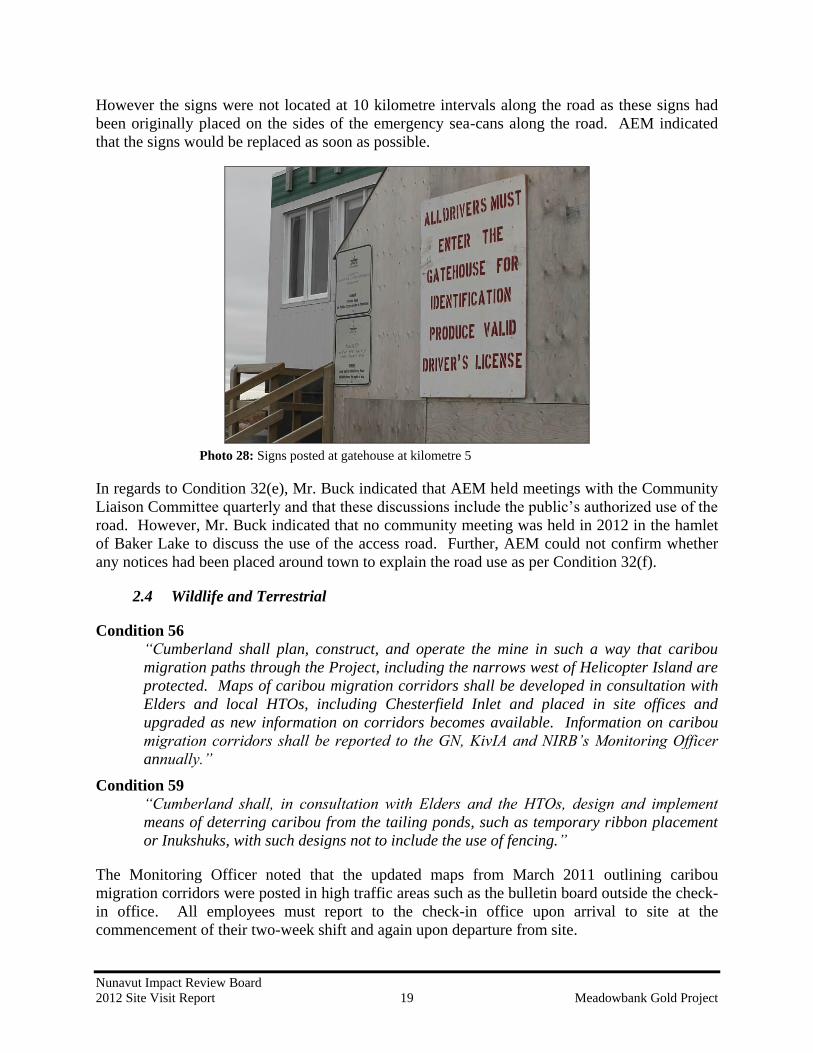
and that the refuge stations were not serving the original and intended purpose. The signs as
required per Condition 32(c) were posted in both English and Inuktitut at the gatehouse (Photo
28) and at each major bridge crossing (on the side of the environmental emergency sea-cans).
Nunavut Impact Review Board
2012 Site Visit Report 19 Meadowbank Gold Project
However the signs were not located at 10 kilometre intervals along the road as these signs had
been originally placed on the sides of the emergency sea-cans along the road. AEM indicated
that the signs would be replaced as soon as possible.
Photo 28: Signs posted at gatehouse at kilometre 5
In regards to Condition 32(e), Mr. Buck indicated that AEM held meetings with the Community
Liaison Committee quarterly and that these discussions include the public’s authorized use of the
road. However, Mr. Buck indicated that no community meeting was held in 2012 in the hamlet
of Baker Lake to discuss the use of the access road. Further, AEM could not confirm whether
any notices had been placed around town to explain the road use as per Condition 32(f).
2.4 Wildlife and Terrestrial
Condition 56
“Cumberland shall plan, construct, and operate the mine in such a way that caribou
migration paths through the Project, including the narrows west of Helicopter Island are
protected. Maps of caribou migration corridors shall be developed in consultation with
Elders and local HTOs, including Chesterfield Inlet and placed in site offices and
upgraded as new information on corridors becomes available. Information on caribou
migration corridors shall be reported to the GN, KivIA and NIRB’s Monitoring Officer
annually.”
Condition 59
“Cumberland shall, in consultation with Elders and the HTOs, design and implement
means of deterring caribou from the tailing ponds, such as temporary ribbon placement
or Inukshuks, with such designs not to include the use of fencing.”
The Monitoring Officer noted that the updated maps from March 2011 outlining caribou
migration corridors were posted in high traffic areas such as the bulletin board outside the check-
in office. All employees must report to the check-in office upon arrival to site at the
commencement of their two-week shift and again upon departure from site.

Nunavut Impact Review Board
2012 Site Visit Report 20 Meadowbank Gold Project
As indicated earlier in the report, the only wildlife observed around site during the 2012 site visit
were Willow Ptarmigan near the air monitoring station. Mr. Buck noted that deterrents appear to
keep birds away from the TSF with the exception of the falcons that had been nesting in the
Portage pit during the summer of 2012.
2.5 Noise
Condition 62
“Cumberland shall develop and implement a noise abatement plan…will be developed in
consultation with Elders, GN, HC, and EC and include:
a. The use of sound meters to monitor sound levels in and around the mine site,
including workers’ on-site living/sleeping quarters and any summer camps
adjacent to the site, and in the local study area, with the locations and design of the
sound meters selected in consultation with HC and EC. Sound meters are to be set
up immediately upon issuance of the Project Certificate for the purpose of
obtaining baseline data, and monitoring during and after operations;
b. …
c. Restrictions on blasting and drilling when migrating caribou, or sensitive local
carnivores or birds may be affected;
d. …
e. …”
Five locations were monitored for noise during the 2011 and 2012 summer periods. Mine
activities such as helicopter and other air traffic, the use of construction and operation heavy
equipment and blasting were found to be the dominant mine noise sources (Photo 29).
Photo 29: Noise monitoring station #5

Nunavut Impact Review Board
2012 Site Visit Report 21 Meadowbank Gold Project
2.6 Human Health
Condition 68
“Cumberland shall, in consultation with Elders, local HTOs and the Meadowbank Gold
Mine SEMC, demonstrate that they are working toward incorporating Inuit societal
values into mine operation policies.”
The Monitoring Officer was informed that several programs are in place to incorporate Inuit
societal values at the mine site. A country food kitchen that is available to prepare traditional
foods has been provided, the kitchen serves traditional foods, and a soapstone carving area has
been provided at site. Suggestions that are brought forward during the Community Liaison
Committee meetings have also been incorporated. Further, AEM has hired an Inuit human
resource person to be on site and has one in each community who is available to listen to any
concerns related to working at the mine site.
2.7 Air Quality
Condition 71
“Cumberland shall, in consultation with EC, install and fund an atmospheric monitoring
station to focus on particulates of concern generated at the mine site. The results of air-
quality monitoring are to be reported annually to NIRB.”
The air monitoring stations were installed by the end of October 2011 and monitoring started in
November 2011 (see Photo 30). Partisol sampling station required heated shelter and electricity,
they are planned to be installed in 2012.
Photo 30: Air monitoring stations
Condition 74
“Cumberland shall employ environmentally protective techniques to suppress any
surface dust.”
Nunavut Impact Review Board
2012 Site Visit Report 22 Meadowbank Gold Project
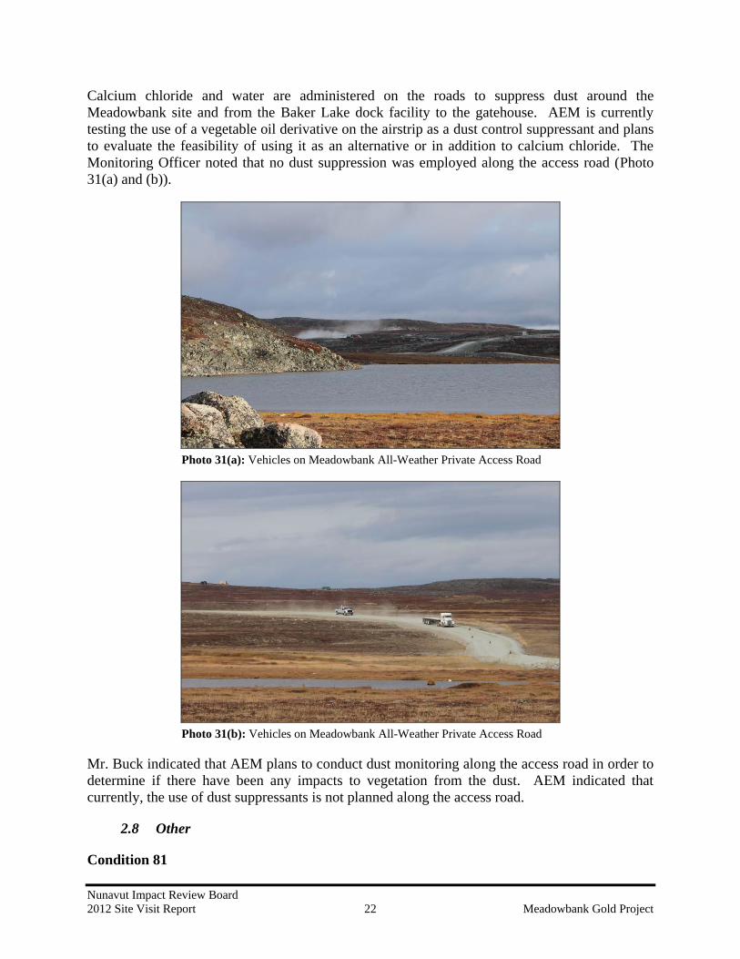
Calcium chloride and water are administered on the roads to suppress dust around the
Meadowbank site and from the Baker Lake dock facility to the gatehouse. AEM is currently
testing the use of a vegetable oil derivative on the airstrip as a dust control suppressant and plans
to evaluate the feasibility of using it as an alternative or in addition to calcium chloride. The
Monitoring Officer noted that no dust suppression was employed along the access road (Photo
31(a) and (b)).
Photo 31(a): Vehicles on Meadowbank All-Weather Private Access Road
Photo 31(b): Vehicles on Meadowbank All-Weather Private Access Road
Mr. Buck indicated that AEM plans to conduct dust monitoring along the access road in order to
determine if there have been any impacts to vegetation from the dust. AEM indicated that
currently, the use of dust suppressants is not planned along the access road.
2.8 Other
Condition 81
Nunavut Impact Review Board
2012 Site Visit Report 23 Meadowbank Gold Project
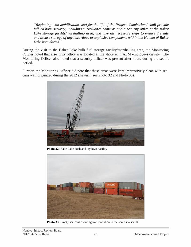
“Beginning with mobilization, and for the life of the Project, Cumberland shall provide
full 24 hour security, including surveillance cameras and a security office at the Baker
Lake storage facility/marshalling area, and take all necessary steps to ensure the safe
and secure storage of any hazardous or explosive components within the Hamlet of Baker
Lake boundaries.”
During the visit to the Baker Lake bulk fuel storage facility/marshalling area, the Monitoring
Officer noted that a security office was located at the shore with AEM employees on site. The
Monitoring Officer also noted that a security officer was present after hours during the sealift
period.
Further, the Monitoring Officer did note that these areas were kept impressively clean with sea-
cans well organized during the 2012 site visit (see Photo 32 and Photo 33).
Photo 32: Bake Lake dock and laydown facility
Photo 33: Empty sea-cans awaiting transportation to the south via sealift

Nunavut Impact Review Board
2012 Site Visit Report 24 Meadowbank Gold Project
3 FINDINGS AND SUMMARY
Based on the observations made during this site visit, all facilities which are in operation and all
sites currently under construction appear to be well managed and maintained with adequate
environmental protection measures and procedures in place.
As with years past, the Proponent appears to be in compliance with a majority of the terms and
conditions contained within the Meadowbank Project Certificate as applicable to the NIRB’s
2012 Site Visit. However, there may be certain situations in which the Proponent has not yet
fully met the requirements of the Meadowbank Project Certificate which may require further
consideration and attention.
The Monitoring Officer notes that the development of the contaminated soil storage/pilot
remediation site is ongoing and that a revised landfarm management plan may be required.
Regarding Condition 8, only one groundwater well appeared to have been operational during the
2012 site visit. The Monitoring Officer acknowledges that further re-evaluation of the
groundwater well monitoring program is to be conducted by AEM.
Condition 25 requires that the Proponent employ legal deterrents to deter carnivores and/or
raptors from the Meadowbank site. In 2012, AEM noted that six pairs of falcons had nested at
different quarry sites, one pair of falcons had nested at Portage pit and one pair of ravens had
nested at the Baker Lake bulk fuel storage facility, which may serve as an indication that the
deterrents are not working at these sites.
Condition 26 requires that spills be cleaned up immediately and that the site be kept clean of
debris. The Monitoring Officer was informed during the 2012 site visit that the spill at kilometre
22 was still undergoing treatment for hydrocarbons. AEM indicated that ongoing monitoring of
this site would continue for an additional 2 years to ensure that no contaminated materials remain
at the site. Furthermore, some instances of wind-blown debris scattered around the site were
noted, possibly requiring management of waste piles or the development of additional on-site
waste management practices.
Condition 27 requires that the Proponent use safe, environmentally protective methods for areas
used to store fuel or hazardous materials. The Monitoring Officer noted that some staining was
observed at the edge of the berm of the fuel tank farm containment facility.
AEM appeared to be following the requirements of amended Condition 32 as were able to be
observed at the site, with the exception of not having the English and Inuktitut signs placed at
every 10 km intervals along the access road as required by item (c).
The Proponent did not appear to have fully met the requirements of Condition 74, as dust
suppression techniques, while applied at the Meadowbank site, had not been applied to the
access road. However, AEM indicated that plans are in place to conduct future dust monitoring
studies along the access road to determine the best options to deal with the dust created on the
access road.

Nunavut Impact Review Board
2012 Site Visit Report 25 Meadowbank Gold Project
Prepared by: Sophia Granchinho
Title: Technical Advisor/Monitoring Officer
Date: November 14, 2012
Signature:
Reviewed by: Amanda Hanson
Title: Director, Technical Services
Date: November 13, 2012
Signature:
Nunavut Impact Review Board
2012 Site Visit Report 26 Meadowbank Gold Project
REFERENCES
AEM. 2011. Agnico-Eagle Mines Limited Detailed Mineral Reserves and Resources Data.
December 2011. Available at: http://agnico-eagle.com/English/Our-Business/Operating-
Mines/Meadowbank/Reserves-and-Resources/default.aspx. Accessed November 14, 2012.
AEM. 2012. Meadowbank Employee Bulletin. Released February 16, 2012.
NIRB. 2006. Final Hearing Report for the Meadowbank Gold Project. Prepared by the
Nunavut Impact Review Board for the Meadowbank Gold Mine Application, Cumberland
Resources Inc. August 2006.
NIRB. 2009. In the matter of an Application by Agnico-Eagle Mines Limited for the Mine
development of the Meadowbank Gold Mine Project Proposal in the Kivalliq Region of
Nunavut, Project Certificate NIRB [No. 004]. Prepared by the Nunavut Impact Review
Board for the Meadowbank Gold Mine Project. Original issued December 2006.
Amendment issued November 2009.