2011-04 Mossy Oaks Road & Springwoods Village … Mossy Oaks Road & Springwoods Village Parkway...
11
2011 Major Thoroughfare and Freeway Plan Amendment Request PLANNING COMMISSION ACTION 04_MossyOaks_SpringwoodsVillage.doc 8/12/2011 http://www.houstontx.gov/planning/DevelopRegs/mobility/MTFP.html 1 2011-04 Mossy Oaks Road & Springwoods Village Parkway APPLICANT: Walter P. Moore and Associates KEY MAP: 291 H, M, R, 292 E, F, J LAMBERT: 5171, 5271 JURISDICTION: Harris County DISTRICT/PRECINCT: Pcnt. 4 PROPOSAL: 1. Realign Mossy Oaks Road between proposed Holzwarth Road and IH 45. 2. Add Springwoods Village Parkway as a major thoroughfare between IH 45 and Spring Stuebner Road APPLICANTS JUSTIFICATION & HISTORY: The subject area was first included on the Major Thoroughfare and Freeway Plan (MTFP) in 1966. Spring Stuebner and proposed FM 2920/Rayford Road are the east-west thoroughfares. Proposed Holzwarth/Sawmill and Gosling Road are the north-south thoroughfares west of IH 45. In 1972, the proposed extension of FM 2920 was deleted west of Gosling and proposed Shaw Road was terminated into Rayford Road extension to the north. In 1980, the proposed extension of FM 2920 was extended west of Gosling along Mossy Oaks Road south of Spring Creek to IH 45. In 1998, the Mossy Oaks Road alignment between Gosling and IH 45 was realigned and labeled as Rayford Road on the MTFP map. In 2007, the Planning Commission denied a request to delete Mossy Oaks between Gosling and Holzwarth Road. However, Mossy Oaks was reclassified as a major collector (70’ ROW) and realigned to be moved outside of the flood plain. The applicant on behalf of Springwoods Reality Company and its developer CDC Houston, Inc. are requesting to realign major thoroughfare Mossy Oaks and add Springwoods Village Parkway through their subject property. The proposed Springwoods Village development will be a new master planned community in northern Harris County south of Spring Creek and west of IH 45. The proposed development plan includes the construction of a one mile long segment of east-west Mossy Oaks Road by 2012. A portion of Springwoods Village Parkway would be constructed in 2011 and the remainder in 2013. The proposed amendments would maintain the east-west mobility provided by Mossy Oaks Road and enhance connectivity between Spring Stuebner, IH 45 and Hardy Toll Road with the proposed Springwoods Village Parkway. The proposed Mossy Oaks Road alignment provides access to the new communities Town Center and healthcare district. The development also allows for the proposed extension of north–south major thoroughfare Holzwarth Road to Sawmill Road across Spring Creek. Access to the Grand Parkway from the proposed development will enhance mobility in the overall area. The applicant has conducted a traffic study with 2025 as the horizon year for the complete development of the proposed Springwoods Village community. The model results indicate that intersections within the community will function with a Level of Service C. The applicant indicates that they have coordinated with Harris County and the state to ensure benefits to regional mobility with the proposed improvements. The community is also being designed to promote and encourage local pedestrian travel with trails and interconnected walkways. Accommodations for bicycles on and off street are also to be provided. The development plans for a future major multimodal transit center to allow for potential access to transit in the region.
Transcript of 2011-04 Mossy Oaks Road & Springwoods Village … Mossy Oaks Road & Springwoods Village Parkway...
2011 Major Thoroughfare and Freeway Plan
Amendment Request
PLANNING COMMISSION ACTION
04_MossyOaks_SpringwoodsVillage.doc 8/12/2011 http://www.houstontx.gov/planning/DevelopRegs/mobility/MTFP.html 1
2011-04 Mossy Oaks Road & Springwoods Village Parkway APPLICANT: Walter P. Moore and Associates KEY MAP: 291 H, M, R, 292 E, F, J LAMBERT: 5171, 5271 JURISDICTION: Harris County DISTRICT/PRECINCT: Pcnt. 4 PROPOSAL: 1. Realign Mossy Oaks Road between proposed Holzwarth Road and IH 45. 2. Add Springwoods Village Parkway as a major thoroughfare between IH 45 and Spring
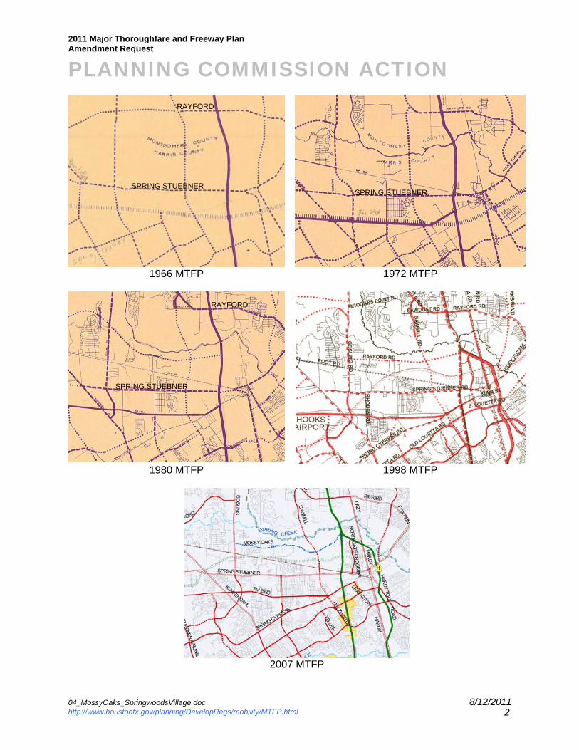
Stuebner Road APPLICANTS JUSTIFICATION & HISTORY: The subject area was first included on the Major Thoroughfare and Freeway Plan (MTFP) in 1966. Spring Stuebner and proposed FM 2920/Rayford Road are the east-west thoroughfares. Proposed Holzwarth/Sawmill and Gosling Road are the north-south thoroughfares west of IH 45. In 1972, the proposed extension of FM 2920 was deleted west of Gosling and proposed Shaw Road was terminated into Rayford Road extension to the north. In 1980, the proposed extension of FM 2920 was extended west of Gosling along Mossy Oaks Road south of Spring Creek to IH 45. In 1998, the Mossy Oaks Road alignment between Gosling and IH 45 was realigned and labeled as Rayford Road on the MTFP map. In 2007, the Planning Commission denied a request to delete Mossy Oaks between Gosling and Holzwarth Road. However, Mossy Oaks was reclassified as a major collector (70’ ROW) and realigned to be moved outside of the flood plain. The applicant on behalf of Springwoods Reality Company and its developer CDC Houston, Inc. are requesting to realign major thoroughfare Mossy Oaks and add Springwoods Village Parkway through their subject property. The proposed Springwoods Village development will be a new master planned community in northern Harris County south of Spring Creek and west of IH 45. The proposed development plan includes the construction of a one mile long segment of east-west Mossy Oaks Road by 2012. A portion of Springwoods Village Parkway would be constructed in 2011 and the remainder in 2013. The proposed amendments would maintain the east-west mobility provided by Mossy Oaks Road and enhance connectivity between Spring Stuebner, IH 45 and Hardy Toll Road with the proposed Springwoods Village Parkway. The proposed Mossy Oaks Road alignment provides access to the new communities Town Center and healthcare district. The development also allows for the proposed extension of north–south major thoroughfare Holzwarth Road to Sawmill Road across Spring Creek. Access to the Grand Parkway from the proposed development will enhance mobility in the overall area. The applicant has conducted a traffic study with 2025 as the horizon year for the complete development of the proposed Springwoods Village community. The model results indicate that intersections within the community will function with a Level of Service C. The applicant indicates that they have coordinated with Harris County and the state to ensure benefits to regional mobility with the proposed improvements. The community is also being designed to promote and encourage local pedestrian travel with trails and interconnected walkways. Accommodations for bicycles on and off street are also to be provided. The development plans for a future major multimodal transit center to allow for potential access to transit in the region.
2011 Major Thoroughfare and Freeway Plan
Amendment Request
PLANNING COMMISSION ACTION
04_MossyOaks_SpringwoodsVillage.doc 8/12/2011 http://www.houstontx.gov/planning/DevelopRegs/mobility/MTFP.html 2
1966 MTFP 1972 MTFP
1980 MTFP 1998 MTFP
2007 MTFP
SPRING STUEBNER
RAYFORD
RAYFORD
SPRING STUEBNER
SPRING STUEBNER
2011 Major Thoroughfare and Freeway Plan
Amendment Request
PLANNING COMMISSION ACTION
04_MossyOaks_SpringwoodsVillage.doc 8/12/2011 http://www.houstontx.gov/planning/DevelopRegs/mobility/MTFP.html 3
STAFF RECOMMENDATION: 1. Realign Mossy Oaks Road between proposed Mossy Oaks Subdivision and IH 45. 2. Add Springwoods Village Parkway as a major thoroughfare between IH 45 and Spring
Stuebner Road STAFF JUSTIFICATION: The proposed Springwoods Village Development is master planned community with residential and commercial/office uses. Recently announced in the Houston Chronicle, Exxon Mobil will be moving its corporate campus to this location by 2014. The area would thus generate significant regional and local trips. With Spring Creek and its flood plain to the north, and the existing Union Pacific railroad and proposed Grand Parkway to the south, access to the subject areas between Gosling and IH 45 is currently limited. Major collector Mossy Oaks is approximately 4.6 miles long and will provide east-west mobility between Gosling and IH 45. Once completed the proposed realignment of Mossy Oaks will traverse the subject site preserving the only east-west travel route between the Grand Parkway and Woodlands Parkway. Proposed Springwoods Village Parkway is a short 2.3 mile long major thoroughfare. It would connect the existing Spring Crossing interchange to the proposed Grand Parkway interchange and extend across the Union Pacific railroad to Spring Stuebner. Spring Stuebner currently terminates at the south bound frontage road along IH 45, thus limiting direct access to north-bound IH 45. The existing Spring Crossing interchange at IH 45 also connects to the Hardy Toll Road providing access to three highways within the region. PLANNING COMMISSION ACTION: 1. Realign Mossy Oaks Road between proposed Mossy Oaks Subdivision and IH 45. 2. Add Springwoods Village Parkway as a major thoroughfare between IH 45 and Spring
Stuebner Road
1. Population & Employment Projections According to 2010 Census, Texas grew by 20% in ten years, to over 25 million people, recording about a quarter of the nation’s overall growth. The rate of growth in Texas was twice the national average. Harris County is the most populous county (4 million) in Texas. Today, 2.1 million people live within the City of Houston and another 2 million live in the City’s extraterritorial jurisdiction (ETJ). Since 2000, the City of Houston added 146,000 people (8 percent) to its population. Houston’s ETJ however grew 35 percent during the same time period. Houston and its ETJ’s rich employment sector are home to more than 1.8 million jobs, making it the state’s most populous and robust economic center. More than one million jobs are located within the City limits and are saturated within the City’s eight major activity centers. One of the greatest challenges to Houston’s mobility is that by 2035 significant numbers of residents are projected to live outside the City limits in the ETJ; while the major thrust of employment growth will be within the City limits. This increase in distance between the population and employment centers will result in more travel, greater travel time, and longer travel delays.

2011 Major Thoroughfare and Freeway Plan
Amendment Request
PLANNING COMMISSION ACTION
04_MossyOaks_SpringwoodsVillage.doc 8/12/2011 http://www.houstontx.gov/planning/DevelopRegs/mobility/MTFP.html 4
While the ETJ is growing, the City will also be taking in an additional 550,000 new residents. The most notable population growth occurs inside Loop 610. It reflects efforts to create a dense urban core through mixed-use development strategies. To compare the result between 2000 and 2010 Census, the subject area’s population grew by 47.6 % from 8,200 to 12,104 and was more than Houston ETJ’s growth.
Year Population(Persons/
Acre) % Chg
Households(Households/
Acre) % Chg
Jobs (Jobs/ Acre)
% Chg
2015 2.88 1.09 0.40
2020 3.29 12.2% 1.25 14.6% 0.47 17.6%
2025 3.73 11.8% 1.40 12.0% 0.53 13.7%
2030 4.05 8.1% 1.54 10.0% 0.60 12.3%
2035 4.95 18.1% 1.88 22.0% 0.74 23.3%
Change (2015 to 2035) 71.7% 72.2% 85.0% City of Houston Change
(2015 to 2035) 14.4% 16.4% 23.8% City of Houston ETJ
Change (2015 to 2035) 53.3% 62.4% 50.9%
Source: H-GAC’s 2035 Regional Growth Forecast * Data represents population, jobs, and households in 4 Traffic Analysis Zones (TAZ) encompassing approximately 5,901 acres around the proposed amendment. Population projections do not include projections for group housing.
The Houston-Galveston Area Council (H-GAC) projects that over the next 20 years (2015 – 2035), the population within the study area* will increase from 16,995 to 29,210 (12,215 persons), or 71.7%. The number of persons per acre is projected to increase from approximately 2.88 to approximately 4.95. During the same period, H-GAC estimates that the total jobs in the subject area will increase from 2,360 to 4,367 (2,107 jobs), or 85.0%. The number of jobs per acre is projected to increase from approximately 0.40 to 0.74.
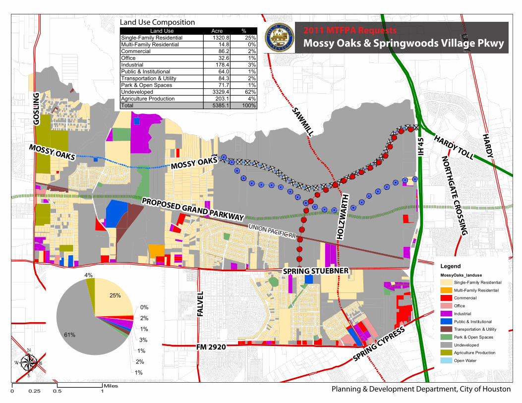
Expressed in percentages, the subject area’s population growth is expected to be more than the City of Houston ETJ’s (71.7% vs. 53.3%), and the area’s job growth is expected to be more than the ETJ’s (85.0% vs. 50.9%). 2. Land use & Platting Activity The study area extends south of Spring Creek between IH 45 and Gosling Road. To the south it extends partially to FM 2920 and Spring Stuebner Road. 59% of the total acreage within the study area is undeveloped. Single family residential is the dominant use in the study area representing approximately 27%. All other uses represent 4% or less each of the overall area. With the exception of the 1500+ acre Springwoods Village development, over the last five years, platting activity in the general area where the Mossy Oaks/Springwoods Village MTFP amendment is being requested has seen single family residential development. The only
2011 Major Thoroughfare and Freeway Plan
Amendment Request
PLANNING COMMISSION ACTION
04_MossyOaks_SpringwoodsVillage.doc 8/12/2011 http://www.houstontx.gov/planning/DevelopRegs/mobility/MTFP.html 5
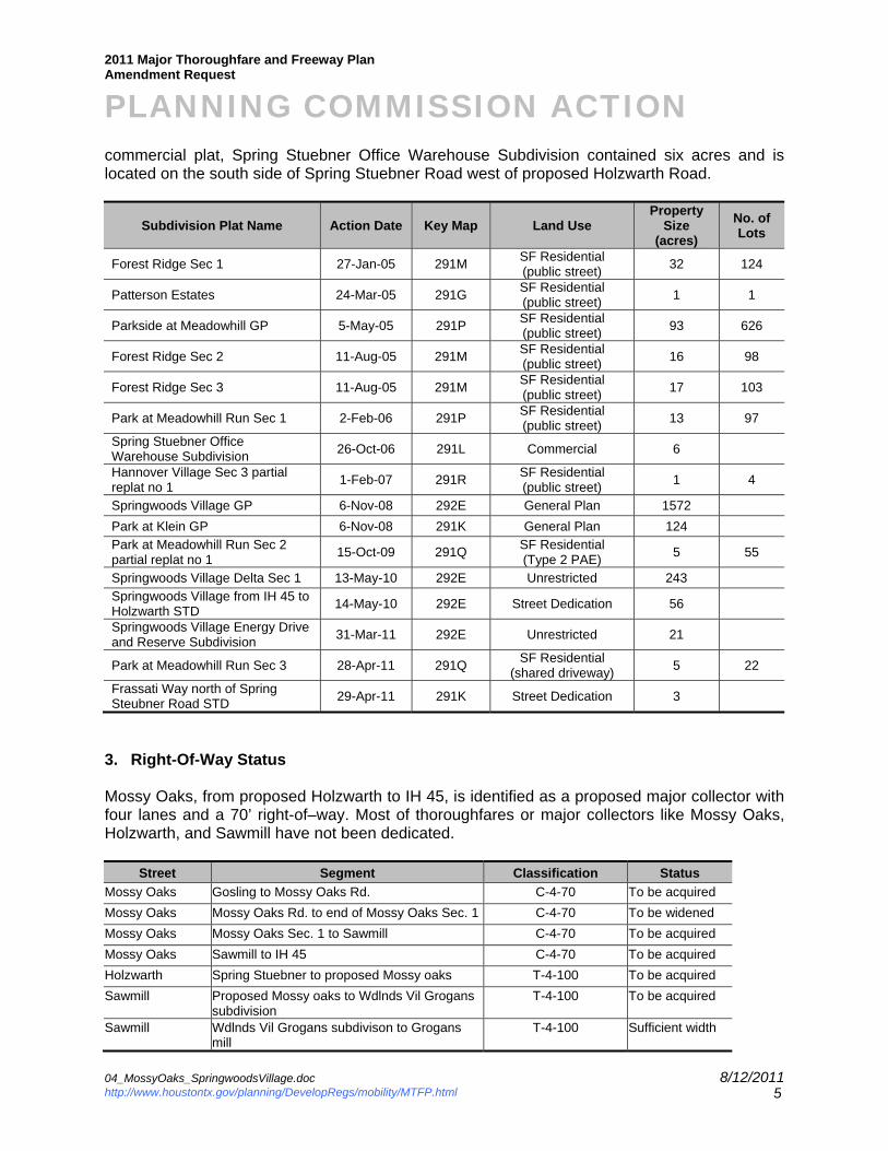
commercial plat, Spring Stuebner Office Warehouse Subdivision contained six acres and is located on the south side of Spring Stuebner Road west of proposed Holzwarth Road.
Subdivision Plat Name Action Date Key Map Land Use Property
Size (acres)
No. of Lots
Forest Ridge Sec 1 27-Jan-05 291M SF Residential (public street)
32 124
Patterson Estates 24-Mar-05 291G SF Residential (public street)
1 1
Parkside at Meadowhill GP 5-May-05 291P SF Residential (public street)
93 626
Forest Ridge Sec 2 11-Aug-05 291M SF Residential (public street)
16 98
Forest Ridge Sec 3 11-Aug-05 291M SF Residential (public street)
17 103
Park at Meadowhill Run Sec 1 2-Feb-06 291P SF Residential (public street)
13 97
Spring Stuebner Office Warehouse Subdivision
26-Oct-06 291L Commercial 6
Hannover Village Sec 3 partial replat no 1
1-Feb-07 291R SF Residential (public street)
1 4
Springwoods Village GP 6-Nov-08 292E General Plan 1572
Park at Klein GP 6-Nov-08 291K General Plan 124 Park at Meadowhill Run Sec 2 partial replat no 1
15-Oct-09 291Q SF Residential (Type 2 PAE)
5 55
Springwoods Village Delta Sec 1 13-May-10 292E Unrestricted 243
Springwoods Village from IH 45 to Holzwarth STD
14-May-10 292E Street Dedication 56
Springwoods Village Energy Drive and Reserve Subdivision
31-Mar-11 292E Unrestricted 21
Park at Meadowhill Run Sec 3 28-Apr-11 291Q SF Residential
(shared driveway) 5 22
Frassati Way north of Spring Steubner Road STD
29-Apr-11 291K Street Dedication 3
3. Right-Of-Way Status Mossy Oaks, from proposed Holzwarth to IH 45, is identified as a proposed major collector with four lanes and a 70’ right-of–way. Most of thoroughfares or major collectors like Mossy Oaks, Holzwarth, and Sawmill have not been dedicated.
Street Segment Classification Status
Mossy Oaks Gosling to Mossy Oaks Rd. C-4-70 To be acquired
Mossy Oaks Mossy Oaks Rd. to end of Mossy Oaks Sec. 1 C-4-70 To be widened
Mossy Oaks Mossy Oaks Sec. 1 to Sawmill C-4-70 To be acquired
Mossy Oaks Sawmill to IH 45 C-4-70 To be acquired
Holzwarth Spring Stuebner to proposed Mossy oaks T-4-100 To be acquired
Sawmill Proposed Mossy oaks to Wdlnds Vil Grogans subdivision
T-4-100 To be acquired
Sawmill Wdlnds Vil Grogans subdivison to Grogans mill
T-4-100 Sufficient width
2011 Major Thoroughfare and Freeway Plan
Amendment Request
PLANNING COMMISSION ACTION
04_MossyOaks_SpringwoodsVillage.doc 8/12/2011 http://www.houstontx.gov/planning/DevelopRegs/mobility/MTFP.html 6
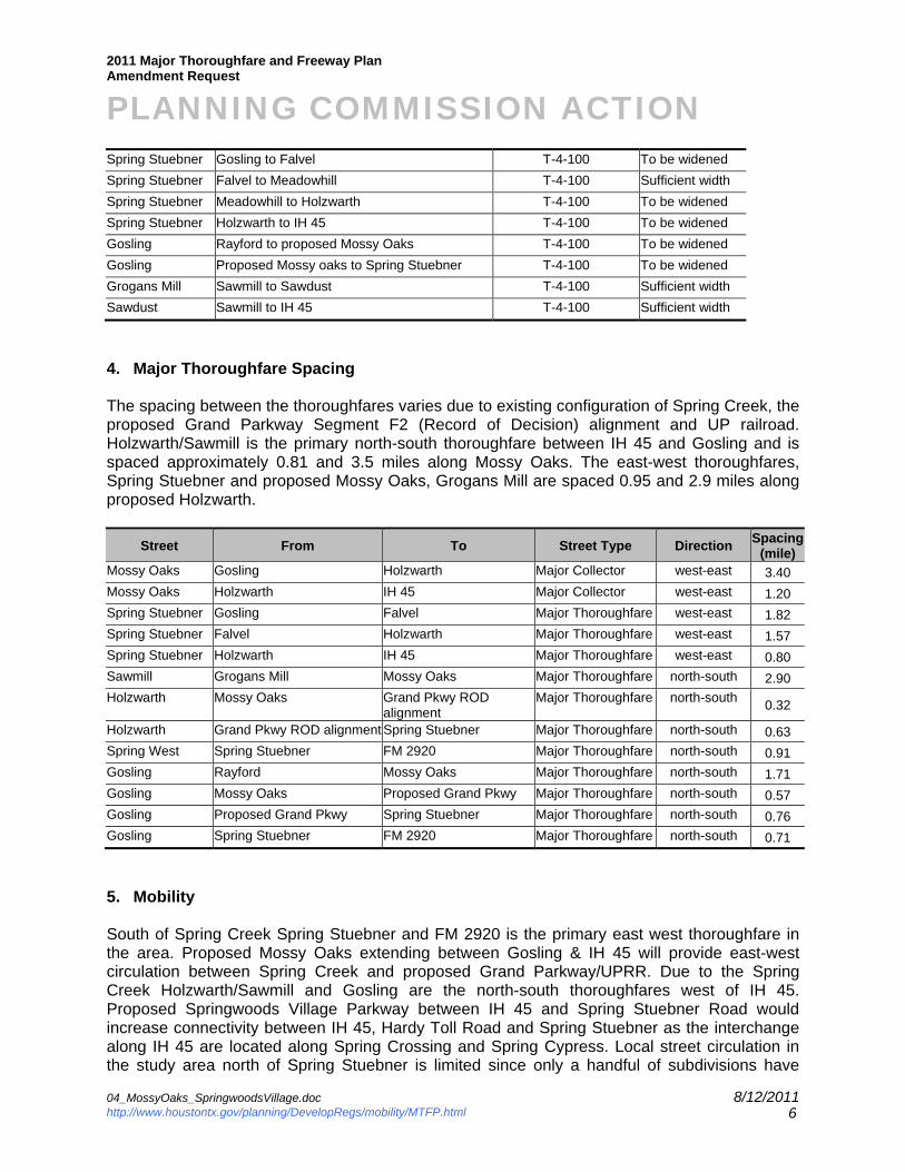
Spring Stuebner Gosling to Falvel T-4-100 To be widened
Spring Stuebner Falvel to Meadowhill T-4-100 Sufficient width
Spring Stuebner Meadowhill to Holzwarth T-4-100 To be widened
Spring Stuebner Holzwarth to IH 45 T-4-100 To be widened
Gosling Rayford to proposed Mossy Oaks T-4-100 To be widened
Gosling Proposed Mossy oaks to Spring Stuebner T-4-100 To be widened
Grogans Mill Sawmill to Sawdust T-4-100 Sufficient width
Sawdust Sawmill to IH 45 T-4-100 Sufficient width
4. Major Thoroughfare Spacing The spacing between the thoroughfares varies due to existing configuration of Spring Creek, the proposed Grand Parkway Segment F2 (Record of Decision) alignment and UP railroad. Holzwarth/Sawmill is the primary north-south thoroughfare between IH 45 and Gosling and is spaced approximately 0.81 and 3.5 miles along Mossy Oaks. The east-west thoroughfares, Spring Stuebner and proposed Mossy Oaks, Grogans Mill are spaced 0.95 and 2.9 miles along proposed Holzwarth.
Street From To Street Type Direction Spacing
(mile) Mossy Oaks Gosling Holzwarth Major Collector west-east 3.40
Mossy Oaks Holzwarth IH 45 Major Collector west-east 1.20
Spring Stuebner Gosling Falvel Major Thoroughfare west-east 1.82
Spring Stuebner Falvel Holzwarth Major Thoroughfare west-east 1.57
Spring Stuebner Holzwarth IH 45 Major Thoroughfare west-east 0.80
Sawmill Grogans Mill Mossy Oaks Major Thoroughfare north-south 2.90
Holzwarth Mossy Oaks Grand Pkwy ROD alignment
Major Thoroughfare north-south 0.32
Holzwarth Grand Pkwy ROD alignment Spring Stuebner Major Thoroughfare north-south 0.63
Spring West Spring Stuebner FM 2920 Major Thoroughfare north-south 0.91
Gosling Rayford Mossy Oaks Major Thoroughfare north-south 1.71
Gosling Mossy Oaks Proposed Grand Pkwy Major Thoroughfare north-south 0.57
Gosling Proposed Grand Pkwy Spring Stuebner Major Thoroughfare north-south 0.76
Gosling Spring Stuebner FM 2920 Major Thoroughfare north-south 0.71
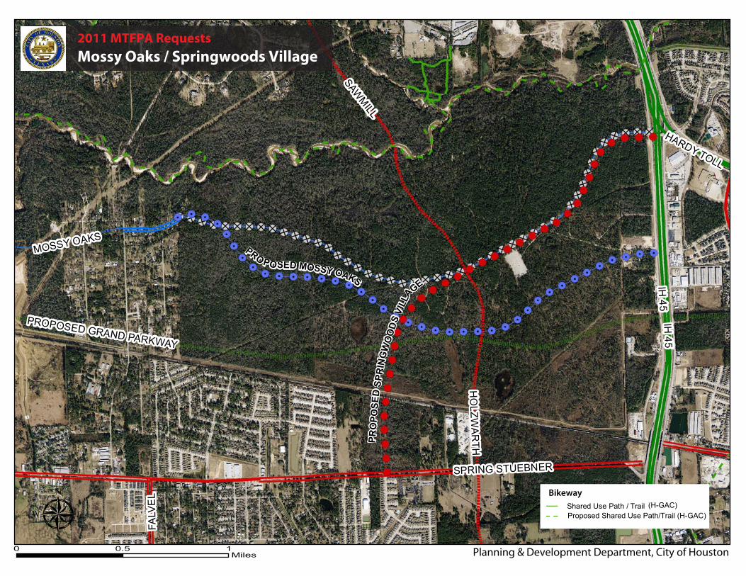
5. Mobility South of Spring Creek Spring Stuebner and FM 2920 is the primary east west thoroughfare in the area. Proposed Mossy Oaks extending between Gosling & IH 45 will provide east-west circulation between Spring Creek and proposed Grand Parkway/UPRR. Due to the Spring Creek Holzwarth/Sawmill and Gosling are the north-south thoroughfares west of IH 45. Proposed Springwoods Village Parkway between IH 45 and Spring Stuebner Road would increase connectivity between IH 45, Hardy Toll Road and Spring Stuebner as the interchange along IH 45 are located along Spring Crossing and Spring Cypress. Local street circulation in the study area north of Spring Stuebner is limited since only a handful of subdivisions have
2011 Major Thoroughfare and Freeway Plan
Amendment Request
PLANNING COMMISSION ACTION
04_MossyOaks_SpringwoodsVillage.doc 8/12/2011 http://www.houstontx.gov/planning/DevelopRegs/mobility/MTFP.html 7
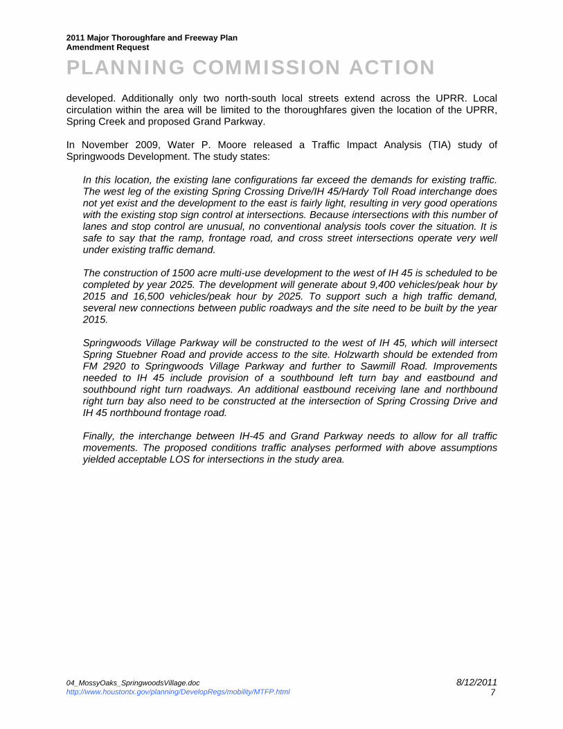
developed. Additionally only two north-south local streets extend across the UPRR. Local circulation within the area will be limited to the thoroughfares given the location of the UPRR, Spring Creek and proposed Grand Parkway. In November 2009, Water P. Moore released a Traffic Impact Analysis (TIA) study of Springwoods Development. The study states:
In this location, the existing lane configurations far exceed the demands for existing traffic. The west leg of the existing Spring Crossing Drive/IH 45/Hardy Toll Road interchange does not yet exist and the development to the east is fairly light, resulting in very good operations with the existing stop sign control at intersections. Because intersections with this number of lanes and stop control are unusual, no conventional analysis tools cover the situation. It is safe to say that the ramp, frontage road, and cross street intersections operate very well under existing traffic demand. The construction of 1500 acre multi-use development to the west of IH 45 is scheduled to be completed by year 2025. The development will generate about 9,400 vehicles/peak hour by 2015 and 16,500 vehicles/peak hour by 2025. To support such a high traffic demand, several new connections between public roadways and the site need to be built by the year 2015. Springwoods Village Parkway will be constructed to the west of IH 45, which will intersect Spring Stuebner Road and provide access to the site. Holzwarth should be extended from FM 2920 to Springwoods Village Parkway and further to Sawmill Road. Improvements needed to IH 45 include provision of a southbound left turn bay and eastbound and southbound right turn roadways. An additional eastbound receiving lane and northbound right turn bay also need to be constructed at the intersection of Spring Crossing Drive and IH 45 northbound frontage road. Finally, the interchange between IH-45 and Grand Parkway needs to allow for all traffic movements. The proposed conditions traffic analyses performed with above assumptions yielded acceptable LOS for intersections in the study area.
SHEET NUMBER
SHEET TITLE
DESIGNED BY
NO.
REVIEWED BY
DRAWN BY
PROJECT NUMBER
DATE
DATE REVISION
P:\7
3\20
08\0
8034
-00\
Cad
\Tra
ffic\
2009
-09-
28 N
ew F
igur
es\7
3-08
034-
00-F
igur
e-16
.dw
gN
ov 0
4, 2
009
- 9:5
6am
W A L TE R P . M O O RE A N D A S S O C I A TE S , IN C .1 3 0 1 M c K I N N E Y , S U I TE 1100
H O U S T O N , TE X A S 77010
P H ON E : 7 1 3 . 6 3 0 . 7300 F AX : 7 1 3 . 6 3 0 . 7396
Copyright C WALTER P. MOORE AND ASSOCIATES, INC. 2009
RVS
RVS
TME
73-08034-00
NOVEMBER 2009
PROJECT NAME
SPRINGWOODSDEVELOPMENT
TRAFFIC STUDY
FIGURE 16
PHASE 2PM PEAK HOUR
LEVEL OF SERVICE
Spring Creek
Spring Creek
0 10.5Miles
Planning & Development Department, City of Houston
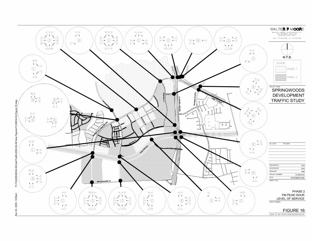
2011 MTFPA Requests
Mossy Oaks / Springwoods Village
IH45
MOSSY OAKS
SPRING STUEBNER
SAWMILL
GRAND PARKWAY ROD ALIGNMENT
GRAND PARKWAY ROD ALIGNMENT
HO
LZW
AR
TH
HA
RD
YTO
LL
FALV
EL
PRO POSED MOSSY OAKS
PRO POSED MOSSY OAKS
GRAND PARKWAY AN
TICIP
ATED ALIGNMENT
GRAND PARKWAY AN
TICIP
ATED ALIGNMENT
PRO
POSE
D S
PRIN
GW
OO
DS
VILL
AGE
PRO
POSE
D S
PRIN
GW
OO
DS
VILL
AGE
Spring C
ross
ing
Blvd
Spring C
ross
ing
Blvd
Cro ssgate Blvd
Cro ssgate Blvd
MTFP 2010Proposed Freeway
TBW Freeway
Freeway
Major Thoroughfare
TBW Major Thoroughfare
Proposed Major Thoroughfare
Major Collector
TBW Major Collector
Proposed Major Collector
Transit Corridor Street
Proposed Grand Parkway
Realign Major Collector
MTFPA Request
Delete Major Collector
Add Major Thoroughfare
Houston City Limits
Limited Purpose Annexation
Houston ETJ
Montgomery Countyy
Harris CountyHHarris County
MOSSY OAKS
FOREST NORTH
HANNOVER VILLAGE
DOVE MEADOWS
MOSSY OAKS
VILLAGES OFNORTHGATE
CROSSING
UNION PACIFIC RR
UNION PACIFIC RR
IH4
5
FM 2920
GO
SL
ING
HA
RD
Y
SPRING STUEBNER
SAW
MILL
PROPOSED GRAND PARKWAY
LOUETTA
FALV
EL
SPRING
CYPRESS
HO
LZ
WA
RT
H
MOSSY OAKS
LA
ZY
HARDY TOLLNO
RT
HG
AT
EC
RO
SS
ING
LEX
ING
TO
N
MOSSY OAKS
LegendMossyOaks_landuse
Single-Family Residential
Multi-Family Residential
Commercial
Office
Industrial
Public & Institutional
Transportation & Utility
Park & Open Spaces
Undeveloped
Agriculture Production
Open Water
0 0.5 10.25Miles
Land Use CompositionLand Use Acre %
Single-Family Residential 1320.8 25%Multi-Family Residential 14.8 0%Commercial 86.2 2%Office 32.6 1%Industrial 178.4 3%Public & Institutional 64.0 1%Transportation & Utility 84.3 2%Park & Open Spaces 71.7 1%Undeveloped 3329.4 62%Agriculture Production 203.1 4%Total 5385.1 100%
Planning & Development Department, City of Houston
LLLLAAA
ZZYYY
2011 MTFPA Requests
Mossy Oaks & Springwoods Village Pkwy
25%
0%
2%
1%
3%
1%
2%
1%
61%
4%
UNION PACIFIC RR
UNION PACIFIC RR
IH 45
SPRING STUEBNER
SAWM
ILL
PROPOSED GRAND PARKWAY
HO
LZWA
RTH
HARDY TOLLFA
LVE
L
MOSSY OAKS
IH 45
PRO POSED MOSSY OAKS
PRO POSED MOSSY OAKS
PRO
POSE
D S
PRIN
GW
OO
DS
VILL
AGE
PRO
POSE
D S
PRIN
GW
OO
DS
VILL
AGE
μ0 10.5
Miles
Shared Use Path / TrailProposed Shared Use Path/Trail (H-GAC)
(H-GAC)Bikeway
Planning & Development Department, City of Houston
2011 MTFPA Requests
Mossy Oaks / Springwoods Village