HIGHLY COMMENDED – CONGREGATION Ocean Forest Lutheran Fellowship, Dalyellup WA
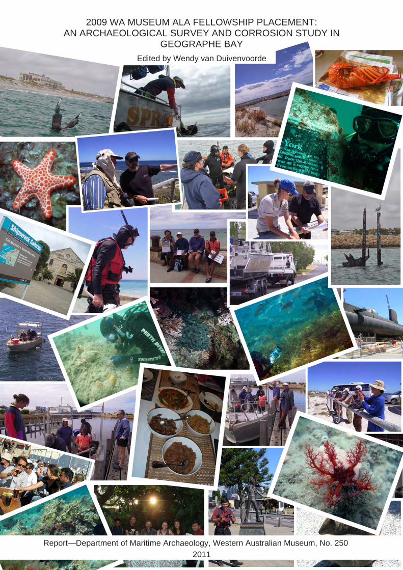
2009 WA MUSEUM ALA FELLOWSHIP PLACEMENT: AN ARCHAEOLOGICAL SURVEY AND CORROSION STUDY IN
GEOGRAPHE BAY Edited by Wendy van Duivenvoorde
Report—Department of Maritime Archaeology, Western Australian Museum, No. 250 2011

First published 2011 Department of Maritime Archaeology Shipwreck Galleries Western Australian Museum 45–47Cliff Street FREMANTLE Western Australia 6160 Enquiries should be to the publisher. © 2011 Western Australian Museum Cover design: Wendy van Duivenvoorde Typesetting: Wendy van Duivenvoorde
2009 WA MUSEUM ALA FELLOWSHIP PLACEMENT: AN ARCHAEOLOGICAL SURVEY AND CORROSION STUDY IN
GEOGRAPHE BAY
Edited by Wendy van Duivenvoorde Report—Department of Maritime Archaeology, Western Australian Museum, No. 250
2011

2

3
To Worrawit Hassapak Whose vibrant personality and infectious smile lifted our spirits
and warmed our hearts

4
CONTRIBUTORS Sophorn Kim Head of Cultural Heritage Office Department of Culture and Fine Arts Battambang Province CAMBODIA NR 10, Kamakar Village, Svaypor Commune Battambang District, Battambang Province Battambang Museum CAMBODIA
Email: [email protected] Phone: (855) 16 896727
Jeremy Green Head of Department Department of Maritime Archaeology Western Australian Museum 45–47 Cliff Street Fremantle, WA 6160 AUSTRALIA
Email: [email protected] Phone: +61 (0)8 9431 8440
Michael McCarthy Senior Curator Department of Maritime Archaeology Western Australian Museum 45–47 Cliff Street Fremantle, WA 6160 AUSTRALIA
Email: [email protected] Phone: +61 (0)8 9431 8436
Ross Anderson Curator Department of Maritime Archaeology Western Australian Museum 45–47 Cliff Street Fremantle, WA 6160 AUSTRALIA
Email: [email protected] Phone: +61 (0)8 9431 8442
Vicki Richards Conservation Scientist/Research Chemist Department of Materials Conservation Shipwreck Galleries Western Australian Museum 45–47 Cliff Street Fremantle, WA 6160 AUSTRALIA
Email: [email protected] Phone: +61 (0)8 9431 8472
Wendy van Duivenvoorde Lecturer in Maritime Archaeology Department of Archaeology Flinders University GPO Box 2100 Adelaide, SA 5001 AUSTRALIA
E-mail: [email protected] Phone: +61 (0)8 8201 5195

5
TABLE OF CONTENTS
List of Figures.......................................................................................................... 9List of Tables........................................................................................................... 111. Introduction......................................................................................................... 12
2009 ALA Fellowship placement at the Western Australian Museum 12Program outline 13ALA Fellowship Placement: Introductory day 15Underwater cultural heritage management workshop 15Visitation WA Museum sites 16Rottnest Island: Underwater cultural heritage and outreach program 16Underwater cultural heritage issues in the Perth metropolitan area 17Archaeological fieldwork and survey in Geographe Bay 18General comment 19In this report 19
2. Report from an ALA Fellow (by Sophorn Kim).................................................... 20Acknowledgements 20Two-week placement: a personal impression 20
3. Cultural Heritage sites in the ALA Fellowship study region (by Michael McCarthy) ................................................................................. 23Jetties 23Background 23Ports and port-related structures and jetties defined 23The jetty examined 24Jetties in the ALA Fellowship study region 26Busselton jetty 26Quindalup jetty 28Wonnerup jetty site and tramway 30Shipwrecks 31The Deadwater (Wonnerup) wreck 31Governor Endicott (1819–1840) 31Halcyon (1819–1844) 32Geffrard 32Mary (1868–1879) 32Whaling sites 33
4. Archaeological site inspections (by Ross Anderson).......................................... 34Wonnerup jetty and Mary shipwreck sites 34Quindalup jetties site inspection 34
5. Quindalup remote sensing survey (by Jeremy Green)........................................ 41Introduction 41The survey 41Conclusions 43
6. Busselton jetty: On-site conservation survey report (by Vicki Richards)............ 44Site location and survey 44Personnel 47
6
Weather and sea conditions 48Description 48General observations 48Degree of site exposure 49Seasonal exposure 50Human disturbance 50Conservation survey results: Metal survey 50
Ferrous Materials 50Conservation survey results: Organic survey 51
Wood 51Sediment 56
Discussion 567. Quindalup jetty: On-site conservation survey report (by Vicki Richards)........... 58
Site location and survey 58Personnel 61Weather and sea conditions 61Description 62General observations 62Degree of site exposure 63Seasonal exposure 64Human disturbance 66Conservation survey results: Metal survey 67
Ferrous materials 67Conservation survey results: Organic survey 71
Wood 71Sediment 73
Discussion 75Appendix A.............................................................................................................. 77Appendix B.............................................................................................................. 78References.............................................................................................................. 79

7
LIST OF FIGURES
Figure 1-1 ALA fellows and participants of the Underwater Cultural Heritage Management Workshop. (Photograph: P. Baker, WA Museum).
15
Figure 1-2 Patrick Baker, Worrawit Hassapak, and Chandraratne Wijamunige diving on the City of York shipwreck, Rottnest Island. (Photograph: R. Anderson, WA Museum)
17
Figure 1-3 Dunsborough fieldwork participants (25–28 February 2009), back row (l–r): Jon Carpenter, Vicki Richards, Ross Anderson, Michael McCarthy, Wendy van Duivenvoorde, Corioli Souter; front row (l-r): Sophorn Kim, Worrawit Hassapak, Chandraratne Wijamunige. (Photograph: P. Baker, WA Museum)
18
Figure 2-1 Tour through the Maritime Museum in Fremantle by Sally May, head of the Department of Maritime History. (Photograph: W. Van Duivenvoorde, WA Museum)
20
Figure 2-2 Climate-control at WA Museum’s collection facilities in Welshpool during a tour by Ian McLeod. (Photograph: S. Kim)
20
Figure 2-3 Workshop in Underwater Cultural Heritage Management. Lecture by Ross Anderson in the attic of the Maritime Archaeology Department, Shipwreck Galleries, WA Museum. (Photograph: W. Van Duivenvoorde, WA Museum)
21
Figure 2-4 Workshop in Underwater Cultural Heritage Management. Lecture by Joel Gilman in the attic of the Maritime Archaeology Department, Shipwreck Galleries, WA Museum. (Photograph: W. Van Duivenvoorde, WA Museum)
21
Figure 2-5 Working in the Rottnest Island Museum on the condition reports of the maritime archaeological artefacts on display. (Photograph: S. Kim)
21
Figure 2-6 With Michael McCarty in the Busselton jetty observatory. (Photograph: W. van Duivenvoorde, WA Museum)
21
Figure 3-1 Busselton jetty, Busselton, WA. (Photograph: P. Baker, WA Museum)
27
Figure 3-2 Historical photographs of the 1854 Quindalup jetty in the Volunteer Sea Rescue building (1941 and 1946). (Photograph: W. Van Duivenvoorde, WA Museum)
29
Figure 4-1 The Quindalup boat ramp jetty and Volunteer Sea Rescue. (Photograph: P. Baker, WA Museum)
34
Figure 4-2 Quindalup boat ramp jetty and Volunteer Sea Rescue building with snorkeler and dive flags in the foreground showing the location of historic jetty debris. (Photograph: P. Baker, WA Museum)
35
Figure 4-3 Quindalup boat ramp jetty with historic jetty pylon visible on right. (Photograph: P. Baker, WA Museum)
35
Figure 4-4 Team planning dive on the Quindalup historic jetty remains. (Photograph: P. Baker, WA Museum)
36
Figure 4-5 Railway iron of Quindalup historic jetty. (Photograph: P. Baker, WA Museum)
37
Figure 4-6 Railway wheels from Quindalup historic jetty. (Photograph: P. Baker, WA Museum)
37

8
Figure 4-7 Close up of bogey from Quindalup historic jetty. (Photograph: P. Baker, WA Museum)
38
Figure 4-8 Side view of bogey from Quindalup historic jetty. (Photograph: P. Baker, WA Museum)
38
Figure 4-9 Buried timber from Quindalup historic jetty. (Photograph: P. Baker, WA Museum)
39
Figure 4-10 Railway bogey from Quindalup historic jetty. Photograph: P. Baker, WA Museum)
39
Figure 4-11 Thick sea grass covering Quindalup historic jetty remains. (Photograph: P. Baker, WA Museum)
40
Figure 5-1 The location of the Geffrard shipwreck on Archdeacon’s 1876 map—geo-referenced and superimposed over aerial photograph of the Quindalup survey area. (ArchGIS: J. Green, WA Museum)
41
Figure 5-2 Magnetometer data of the survey at Quindalup showing the survey lanes in search of the whaler shipwreck. The purple dots indicate the boat’s survey track, the two large contours anomalies in red are the jetty and an unknown site. (ArchGIS: J. Green, WA Museum)
42
Figure 5-3 Side-scan sonar survey in the area of Geffrard shipwreck. (ArchGIS: J. Green, WA Museum)
42
Figure 6-1 Busselton jetty, Busselton, WA. (Google Earth 2009) 44Figure 6-2 Visitors inside the Underwater Observatory.
(Photograph: R. Anderson) 45
Figure 6-3 The approximate position of the survey area adjacent to the Underwater Observatory, Busselton jetty. (Google Earth 2009)
45
Figure 6-4 Under water view of the seaward side of the Observatory and colonised wooden piles from the Busselton jetty. (Photograph: R. Anderson, WA Museum)
46
Figure 6-5 Survey pile approximately 10m north east from the seaward side of the Observatory. (Photograph: R. Anderson, WA Museum)
46
Figure 6-6 Marine growth on historical wooden piles, Busselton jetty. (Photograph: R. Anderson, WA Museum)
46
Figure 6-7 Marine growth on historical wooden piles, Busselton jetty. (Photograph: R. Anderson, WA Museum)
46
Figure 6-8 Anchor on the survey site, Busselton jetty. (Photograph: R. Anderson, WA Museum)
49
Figure 6-9 Pourbaix diagram for iron (10-6M) in aerobic sea water at 25C indicating the state of the iron bollard on the Busselton jetty site. (Diagram: V. Richards, WA Museum)
51
Figure 6-10 Iron bollard used for the corrosion survey, Busselton jetty. (Photograph: R. Anderson, WA Museum)
52
Figure 6-11 ALA fellows taking core samples from wooden pylons of the Busselton jetty. (Photograph: R. Anderson, WA Museum)
53
Figure 6-12 pH profiles of the wooden pile measured on the Busselton jetty. (Graph: V. Richards, WA Museum)
54
Figure 6-13 Sediment core sample (BTJ 43) from the Busselton jetty survey site. (Photograph: V. Richards, WA Museum)
55

9
Figure 7-1 Quindalup jetty remains, Quindalup, WA (Google Earth 2009). 58Figure 7-2 The Quindalup jetty site, Quindalup, WA. (Photograph: P. Baker,
WA Museum) 59
Figure 7-3 Conservation staff measuring corrosion parameters on an iron wheel on the Quindalup jetty, WA. (Photograph: P. Baker, WA Museum)
60
Figure 7-4 Change in dissolved oxygen concentration with increasing water depth on the Quindalup jetty site. (Graph: V. Richards, WA Museum)
62
Figure 7-5 Two iron wheels and the remains of one jetty pile. (Photograph: P. Baker, WA Museum)
63
Figure 7-6 The remains of an iron track. (Photograph: P. Baker, WA Museum) 63Figure 7-7 Concreted surfaces of an iron railway wheel. (Photograph: P.
Baker, WA Museum) 64
Figure 7-8 Degradation of a jetty pile by marine borers. (Photograph: P. Baker, WA Museum)
64
Figure 7-9 Survey area seabed with dead seagrass. (Photograph: P. Baker, WA Museum)
64
Figure 7-10 Scouring of the seagrass around the iron wheels. (Photograph: P. Baker, WA Museum)
64
Figure 7-11 Buried iron wheel. (Photograph: P. Baker, WA Museum) 65Figure 7-12 Buried jetty pile remains with evidence of previous marine borer
damage. (Photograph: P. Baker, WA Museum) 65
Figure 7-13 Mooring with chain located on the Quindalup jetty site. (Photograph: P. Baker, WA Museum)
66
Figure 7-14 Positions of the iron wheels measured on the Quindalup jetty site. (Photograph: P. Baker, WA Museum)
67
Figure 7-15 Measurement positions on the exposed sections of the railway track. (Photograph: P. Baker, WA Museum)
67
Figure 7-16 Positions of the corrosion measurements on wheel 2. (Photograph: P. Baker, WA Museum)
67
Figure 7-17 Measurement position on the buried section of the railway track. (Photograph: P. Baker, WA Museum)
67
Figure 7-18 Pourbaix diagram for iron (10-6M) in aerobic seawater at 25C indicating the state of the exposed iron artefacts on the Quindalup jetty site.
68
Figure 7-19 Pourbaix diagram for iron in anaerobic seawater at 25°C indicating the state of the buried iron artefacts on the Quindalup jetty site (Peters, 1977: PAGE NUMBER).
69
Figure 7-20 Location of Jetty Pile 1 adjacent to the iron bogey (wheels 2 and 3). (Photograph: P. Baker, WA Museum)
71
Figure 7-21 Buried jetty Pile 2 forward of the iron bogey (wheels 2 and 3). (Photograph: P. Baker, WA Museum)
71
Figure 7-22 pH profiles of the jetty pile remains measured on the Quindalup jetty. (Graph: V. Richards, WA Museum)
72
10
Figure 7-23 Sediment core sample (QJ 55) from the Quindalup jetty site. (Photograph: V. Richards, WA Museum)
74
11
LIST OF TABLES
Table 6-1 Tidal predictions for Bunbury, WA (http://www.dpi.wa.gov.au/imarine/19102.asp)
46
Table 6-2 Corrosion parameters of the iron bollard on the Busselton jetty site. 50Table 6-3 Results of the pH profiles on the survey pile from the Busselton
jetty. 52
Table 7-1 Tidal predictions for Bunbury, WA. (http://www.dpi.wa.gov.au/imarine/19102.asp)
61
Table 7-2 Temperature, salinity and dissolved oxygen content of the water column on the Quindalup jetty site.
61
Table 7-3 Corrosion parameters of the ferrous artefacts measured on the Quindalup jetty site.
68
Table 7-4 Results of the pH profiles on the jetty pile remains on the Quindalup jetty site.
71

12
1. INTRODUCTION In 2008, the Maritime Archaeology Program at Flinders University was awarded funding from the Australian Leadership Awards (ALA) Fellowships program to bring eleven mid-career professionals involved in maritime archaeology from the Asia-Pacific region to Australia for a 6-week intensive training program in underwater cultural heritage management. From mid-January to March 2009, fellows from Sri Lanka, India, Thailand, Cambodia, Indonesia, and the Philippines took two intensive graduate topics and participated in maritime archaeology field school of Flinders University’s Maritime Archaeology Program. Their curriculum continued with a two-week placement or internship at a museum, underwater cultural heritage agency, or related organization. With the ALA Fellowship program, the Maritime Archaeology Program of Flinders University intended to establish “sustained leadership in building an integrated maritime archaeology program and for teaching excellence using an innovative curriculum including work-integrated learning to produce job-ready graduates” (Staniforth 2008: 69). As described by Mark Staniforth (2008: 70):
The Australian Leadership Awards Fellowships are a component of a regional program that aims to develop leadership and build partnerships and Iinkages with the Asia-Pacific region. They are intended for those in or have the potential to assume leadership positions and who thus can influence social and economic policy reform and development outcomes, both in their own countries and in the Asia-Pacific region. ALA Fellowships are for short-term study, research, and professional attachment programs in Australia delivered by Australian organizations, and complement the longer-term ALA Scholarships by providing opportunities to senior officials and mid-career professionals who cannot leave their positions for extended periods. ALA Fellowships are .available across a broad range of fields relevant to Australia's foreign policy agenda or development outcomes within the Asia-Pacific region.”
2009 ALA Fellowship placement at the Western Australian Museum
From 16 February to 1 March 2009, the staff of the Department of Maritime Archaeology hosted a two-week placement at the Western Australian (WA) Museum as part of the ALA Fellowship program. The WA Museum’s placement activities included workshops, lectures, museum visits (including behind-the-scenes tours), practical fieldwork, and networking relating to underwater cultural heritage management. The three fellows placed with the WA Museum were:
1. Mr Sophorn Kim (Cambodia); 2. Mr Worrawit Hassapak (Thailand); 3. and Mr Chandraratne Wijamunige (Sri Lanka).
The two-week program provided intensive contact hours between the three ALA fellows and museum staff, and the museum’s industry partners. The main aim of the program offered by the WA Museum was to assist their professional development and expand their professional networks in the field.

13
Program outline
Week 1
Tuesday, 17 February 2009: Reconnaissance and Introduction
Time Activity Lecturer
9:00–10:30 Tour: Shipwreck Galleries, Dutch Collection, Hartogh to De Vlamingh Exhibition
Wendy van Duivenvoorde (Maritime Archaeology, WA Museum)
10:45–12:00 Tour: Shipwreck Galleries, Behind the scenes (Department of Maritime Archaeology and Materials Conservation) and introduction to staff
Jeremy Green (Maritime Archaeology, WA Museum), Ian Godfrey (Materials Conservation, WA Museum)
12:00–13:00 Lunch break
13:00–14:00 Tour: Shipwreck Galleries, Xantho Gallery Michael McCarthy (Maritime Archaeology, WA Museum)
14:00–15:00 Tour: Submarine Ovens Michael Mills (Volunteer, WA Museum)
15:15–17:00 Tour: New Maritime Museum Sally May (Maritime History, WA Museum)
Wednesday, 18 February 2009: Underwater Cultural Heritage Management Workshop
Time Activity Lecturer
9:00–9:15 Introduction Wendy van Duivenvoorde (Maritime Archaeology, WA Museum)
9:15–10:30 Lecture: The beginnings of Underwater Cultural Heritage Management in Western Australia (before legislation)
Jeremy Green (Maritime Archaeology, WA Museum)
10:45–12:00 Lecture: Legislation, Maritime Archaeology Act 1973, Commonwealth Historic Shipwrecks Act 1976, and Relic/Shipwreck Reporting
Ross Anderson (Maritime Archaeology, WA Museum)
12:00–13:00 Lunch break
13:00–14:00 Lecture: International legislation, Advisory Council on Underwater Archaeology, and salvage rights
Joel Gilman (Heritage Council WA)
14:00–15:00 Lecture: Amnesty Collections in Australia Jennifer Rodrigues (Maritime Archaeology, WA Museum)
15:15–16:15 Lecture: Coin and Relic’s transfers Corioli Souter (Maritime Archaeology, WA Museum)
Thursday, 19 February 2009: Shipwreck Trails and Underwater Cultural Heritage Management
Time Activity Lecturer/Staff
9:00–10:00 Lecture: Rottnest Island Shipwreck Trail and other Trails in Western Australia
Wendy van Duivenvoorde (Maritime Archaeology, WA Museum)
10:00–17:00 Visit to Rottnest Island (buss and heritage tour)
Michael McCarthy (Maritime Archaeology, WA Museum) and Rottnest Island Authority Staff

14
Week 1
Friday and Saturday, 20–21 February 2009: Rottnest Island Maritime Heritage Trail
Time Activity Staff
9:00–17:00 Rottnest Island underwater heritage tour, visitation of the underwater shipwreck sites and shipwreck inspections
Patrick Baker, Corioli Souter, Ross Anderson, and Wendy van Duivenvoorde (Maritime Archaeology, WA Museum).
Saturday evening: Dinner with Department of Maritime Archaeology and Material Conservation Staff, Friends, and volunteers.
Week 2
Monday, 23 February 2009: Metropolitan Shipwreck Sites and Collection Issues Preserving our Shipwrecks for the Future: In-situ Preservation, Monitoring, Research, Collection
Management, and Public Projects
Time Activity Lecturer
9:00–9:45 Lecture: The Omeo Project Ian Warne (Volunteer, MAAWA), and Michael McCarthy (Maritime Archaeology, WA Museum)
9:45–10:30 Lecture: The James Matthews Project Vicki Richards (Materials Conservation, WA Museum)
10:30–11:30 Lecture: The Sepia Project Corioli Souter (Maritime Archaeology, WA Museum).
11:30–12:30 Lunch break (Fremantle Arts Gallery and Museum)
12:30–13:30 Tour: Weick Gallery, storage and management issues of the WA Museum’s maritime collections: a show-case.
Collection Manager (Maritime Archaeology, WA Museum)
14:30–17:00 Tour: WA Museum at Welshpool, new collection facility (storage and management issues of entire museum collection)
David Gilroy (Collections, WA Museum)
Tuesday, 24 February 2009: Metropolitan Shipwreck Sites
Time Activity Staff
9:00–17:00 Visit of Omeo, Sepia, and James Matthews Metropolitan Shipwreck Sites.
Vicki Richards (Materials Conservation, WA Museum), and Patrick Baker, Corioli Souter, Ross Anderson, Wendy van Duivenvoorde (Maritime Archaeology, WA Museum)
19:30–21:30 Meeting and public lecture: Maritime Archaeological Association of Western Australia (MAAWA) Monthly Meeting.
Wednesday to Saturday, 25–28 February 2009: Underwater Cultural Management II
Time Activity Staff
9:00–17:00 Fieldwork project and trip to Western Australia’s southwest coast. Busselton jetty, shore whaling station, and local museums, Geographe Bay’s remote-sensing survey, and HMAS Swan corrosion study.
Vicki Richards, Jon Carpenter (Materials Conservation, WA Museum), and Patrick Baker, Corioli Souter, Ross Anderson, Wendy van Duivenvoorde, Michael McCarthy, Jeremy Green (Maritime Archaeology, WA Museum)
15
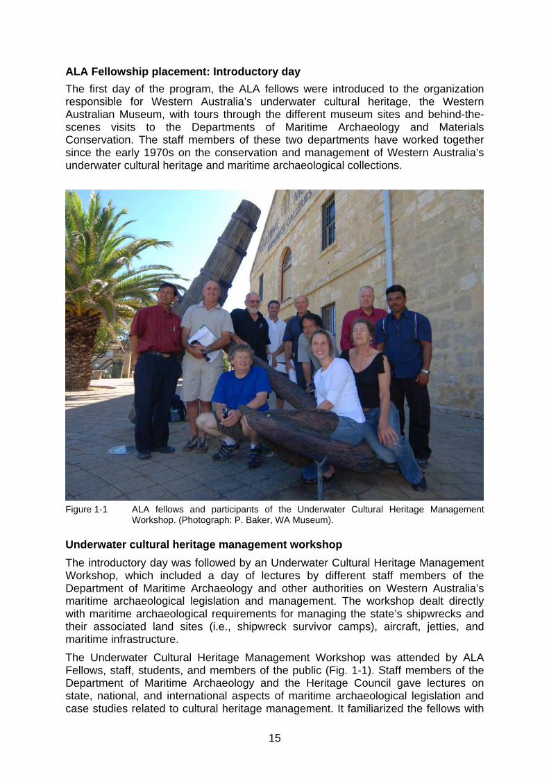
ALA Fellowship placement: Introductory day
The first day of the program, the ALA fellows were introduced to the organization responsible for Western Australia’s underwater cultural heritage, the Western Australian Museum, with tours through the different museum sites and behind-the-scenes visits to the Departments of Maritime Archaeology and Materials Conservation. The staff members of these two departments have worked together since the early 1970s on the conservation and management of Western Australia’s underwater cultural heritage and maritime archaeological collections.
Figure 1-1 ALA fellows and participants of the Underwater Cultural Heritage Management
Workshop. (Photograph: P. Baker, WA Museum). Underwater cultural heritage management workshop
The introductory day was followed by an Underwater Cultural Heritage Management Workshop, which included a day of lectures by different staff members of the Department of Maritime Archaeology and other authorities on Western Australia’s maritime archaeological legislation and management. The workshop dealt directly with maritime archaeological requirements for managing the state’s shipwrecks and their associated land sites (i.e., shipwreck survivor camps), aircraft, jetties, and maritime infrastructure. The Underwater Cultural Heritage Management Workshop was attended by ALA Fellows, staff, students, and members of the public (Fig. 1-1). Staff members of the Department of Maritime Archaeology and the Heritage Council gave lectures on state, national, and international aspects of maritime archaeological legislation and case studies related to cultural heritage management. It familiarized the fellows with
16
the maritime archaeology legislation of Western Australia (as well as Australia and other countries, and the UNESCO Convention on the Protection of the Underwater Cultural Heritage) and outlined the WA Museum’s statutory roles and responsibilities. Visitation WA Museum sites
In addition to the workshop, the ALA Fellows spent two days visiting WA Museum sites, including a tour of its state-of-the-art climate-controlled collection and research facility at Welshpool and other collection areas that have no climate control. Staff and fellows discussed issues related to the long-term management of large maritime archaeological museum collections. The museum tour and workshop allowed the three fellows to meet WA Museum staff and familiarize themselves with the Maritime Archaeology Department’s responsibilities and management protocols for Western Australia’s underwater cultural heritage. Rottnest Island: Underwater cultural heritage and outreach program
An important aspect of the WA Museum’s overall underwater heritage management strategy is its outreach program, which includes the State’s maritime heritage parks, also known as shipwreck trails. Since 1981, the Department has developed 21 maritime heritage parks in Western Australia with the help of school groups participating in the work experience scheme, disadvantaged young adults, and academic extension groups. The heritage-park project has a broad base and is relevant to the general community, tourism industry, and dive operators. Senior curator Michael McCarthy established the first maritime heritage trail in Australia at Rottnest Island, for both recreational and educational purposes. It targets divers and non-divers, such as walkers, cyclists, the aged, and the infirm. Each shipwreck site is marked below and above water with an information plaque (glass below and brass above), and those interested can obtain an information pamphlet on the Rottnest Island shipwreck trail from the Shipwreck Galleries of the Western Australian Museum, the Rottnest Island Authority or on-line. The historic shipwrecks found around Rottnest Island are located within the zone controlled by the Rottnest Island Authority. During the last three days of the first week of the placement, the three fellows visited Rottnest Island. They toured around the island with McCarthy and the staff of the Rottnest Island Authority and visited the non-diving part of the marine park, significant heritage sites, and the local museum. Best-practice underwater cultural heritage management includes a public access strategy with a strong outreach program. The fellows were briefed on the background and management of WA’s maritime heritage parks, and visited Rottnest Island for one day to tour around the island and learn about the shipwreck trail on land. The Rottnest Island Authority supported the ALA Fellowship program allocating staff time and touring the fellows around the island with the CEO’s vehicle. The second day two fellows visited some of the shipwreck sites around Rottnest Island (City of York and Macedon) and performed shipwreck inspections with WA Museum staff (Fig. 1-2). They participated in boating and diving operational procedures and were exposed to wreck inspection methodologies, and different underwater cultural heritage site types and site environments.

17
On this day, Sophorn Kim, the only non-diving fellow, visited the Rottnest Island Museum with WA Museum and Rottnest Island Authority staff to conduct conservation and environmental assessments of the maritime archaeological artefacts in the museum, and the historic shipwreck anchors on the island as part of the historic shipwreck management plan.
Figure 1-2 Patrick Baker, Worrawit Hassapak, and Chandraratne Wijamunige diving on the City
of York shipwreck, Rottnest Island. (Photograph: R. Anderson, WA Museum) Underwater cultural heritage issues in the Perth metropolitan area
The second week of the ALA Fellowship placement began with two days focussing on cultural heritage matters involving maritime archaeological sites in the Perth metropolitan area, and storage and management issues of the WA Museum’s maritime archaeological collections. Staff members of the WA Museum and volunteers from the Maritime Archaeological Association of Western Australia presented three historic shipwreck sites in the metropolitan area that showcase current issues, research projects, and new initiatives for underwater cultural heritage management in urban environments. The Omeo shipwreck, for example, was under threat from a major development project, but through legislative and managerial collaboration has now become a centrepiece for diving and tourism access and interpretation. Sepia was chosen as a research project on colonial shipping, metropolitan shipwrecks, salvage, artefact studies, and seafaring, placing it in the broader context of 19th-century trade and importation of goods to Australia. The James Matthews shipwreck, which also is under threat from local coastal and industrial processes, is the subject of a large-scale in situ preservation project with worldwide collaborative partnerships. The fellows were introduced to the underwater

18
cultural management issues, responsibilities and strategies surrounding these three case studies, and visited the Omeo and James Matthews sites. Unfortunately, the planned dive on the Sepia shipwreck had to be cancelled due to strong southerly winds, but the other two site dives were more than enough for the second day of this activity. They also assisted staff from the WA Museum’s Department of Material Conservation with taking sediment samples and corrosion measurements. The visibility on the James Matthews site was the best ever experienced by museum divers, which added value to the visit.
Figure 1-3 Dunsborough fieldwork participants (25–28 February 2009), back row (l–r): Jon
Carpenter, Vicki Richards, Ross Anderson, Michael McCarthy, Wendy van Duivenvoorde, Corioli Souter; front row (l-r): Sophorn Kim, Worrawit Hassapak, Chandraratne Wijamunige. Photograph: P. Baker, WA Museum.
Archaeological fieldwork and survey in Geographe Bay
During the last four days of the ALA Fellowship placement, the fellows travelled along Western Australia’s southwest coast for a four-day archaeological fieldwork project. The trip included a visit to Busselton jetty (the longest wooden jetty or pier in the southern hemisphere), Quindalup jetty remains, Castle Rock shore whaling station, and local museums in the southwest area with maritime archaeological collections. The overall aim of this fieldwork was to conduct a remote-sensing search for the American whalers Governor Endicott (1840) and Halycon (1844) and corrosion studies of the jetties in this area. The visit to Busselton and the southwest coast exposed the fellows to field survey methods and on-going monitoring of the historic jetties. They dived on the Busselton jetty and participated in the Department of Materials Conservation’s monitoring of the jetty piles, and also visited the jetty’s underwater observatory. The remote-sensing search for the whaling ships produced no promising sites in the search area, and it is

19
believed that modern boat moorings in the vicinity of the wrecks are masking any likely targets. During these efforts, the fellows participated in underwater cultural heritage management activities involving historic site inspections and shipwreck surveys, which are part of the regular work of staff of the Departments of Maritime Archaeology and Materials Conservation (Fig. 1-3). General comment
The WA Museum provided the fellows with research and reference materials, which included a full set of AIMA Bulletins and Special Publications, departmental reports, shipwreck trail flyers, and other professional library reference publications tho aid their professional development, as well as a copy of most PowerPoint presentations used as lecture material during the program for future reference. In addition, several DVDs were made with electronic copies of all departmental reports, shipwreck trail flyers, public access/ interpretive materials, and 180+ M.A. theses and Ph.D. dissertations of different Maritime Archaeology Programs in the world. In addition, industry partners were keen to donate publications related to underwater cultural heritage or maritime archaeological film documentaries, such as Prospero Productions’ Shipwreck Detectives television series. The intensive contact hours between the ALA fellows, museum staff, and the museum’s industry partners went beyond the placement’s planned activities. Evening activities organized by museum staff were keenly attended by the fellows, and they left Western Australia with newly developed professional relationships and many new colleagues and friends. In this report
This report includes an account of Kim Sophorn’s overall experience of the two-week placement. It also details the results of the four-day archaeological fieldwork conducted in the Geographe Bay area, i.e., an overview of archaeological sites in the area, results of the remote-sensing search for the 1840s American whalers Governor Endicott and Halycon, and a full description of the corrosion study of the jetties in his area.
20
2. REPORT FROM AN ALA FELLOW
By Sophorn Kim Acknowledgements
First, I would like to express my profound gratitude to the AusAID ALA Fellowship Programme for inviting me to participate in this training course. Special thanks go to the staff members of the Department of Maritime Archaeology, Shipwreck Galleries, WA Museum, for providing a challenging placement program. They also were very patient in helping me understand many new concepts and the English language. Without this placement, I would not have known about the vast amount of underwater cultural heritage in Western Australia, and the hard work involved with managing this resource. I truly appreciate my placement in Perth: it was a great honour and pleasure to be there. Two-week placement: a personal impression
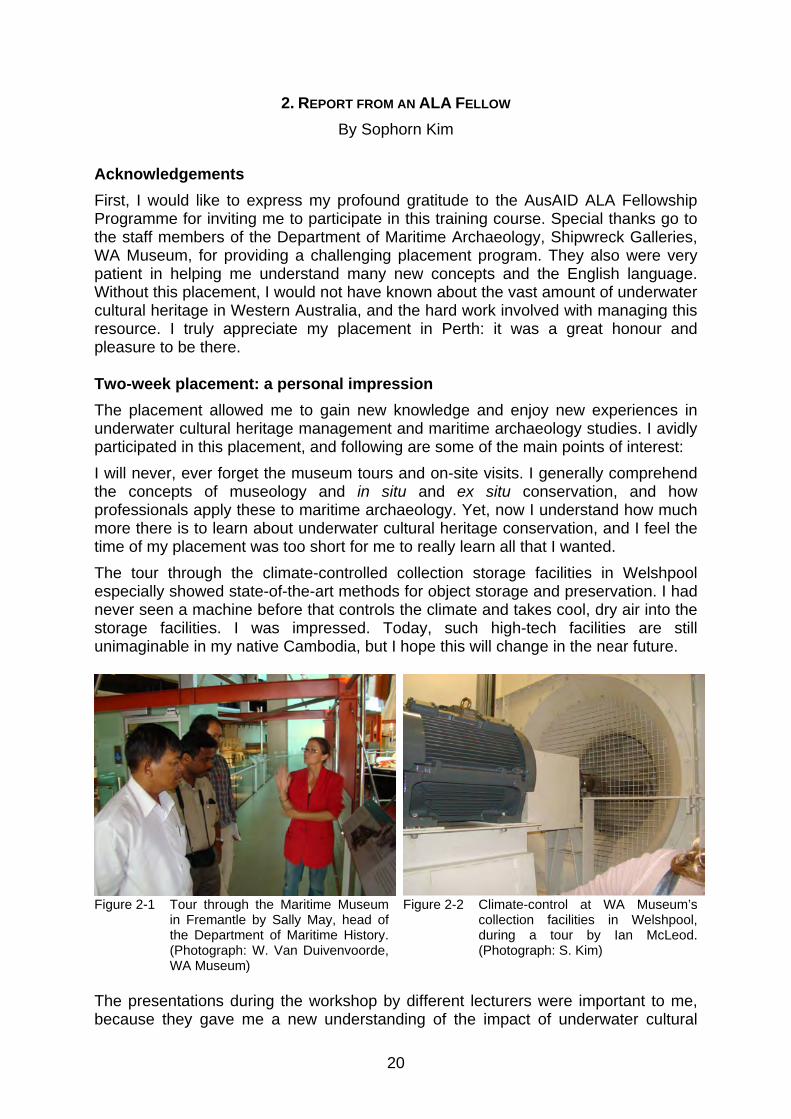
The placement allowed me to gain new knowledge and enjoy new experiences in underwater cultural heritage management and maritime archaeology studies. I avidly participated in this placement, and following are some of the main points of interest: I will never, ever forget the museum tours and on-site visits. I generally comprehend the concepts of museology and in situ and ex situ conservation, and how professionals apply these to maritime archaeology. Yet, now I understand how much more there is to learn about underwater cultural heritage conservation, and I feel the time of my placement was too short for me to really learn all that I wanted. The tour through the climate-controlled collection storage facilities in Welshpool especially showed state-of-the-art methods for object storage and preservation. I had never seen a machine before that controls the climate and takes cool, dry air into the storage facilities. I was impressed. Today, such high-tech facilities are still unimaginable in my native Cambodia, but I hope this will change in the near future.
Figure 2-1 Tour through the Maritime Museum in Fremantle by Sally May, head of the Department of Maritime History. (Photograph: W. Van Duivenvoorde, WA Museum)
Figure 2-2 Climate-control at WA Museum’s collection facilities in Welshpool, during a tour by Ian McLeod. (Photograph: S. Kim)
The presentations during the workshop by different lecturers were important to me, because they gave me a new understanding of the impact of underwater cultural

21
heritage and the work involved with maritime archaeology; even though I struggled at times to understand the English or Australian accent of the speakers.
Figure 2-3 Workshop in Underwater Cultural Heritage Management. Lecture by Ross Anderson in the attic of the Maritime Archaeology Department, Shipwreck Galleries, WA Museum. (Photograph: W. Van Duivenvoorde, WA Museum)
Figure 2-4 Workshop in Underwater Cultural Heritage Management. Lecture by Joel Gilman in the attic of the Maritime Archaeology Department, Shipwreck Galleries, WA Museum. (Photograph: W. Van Duivenvoorde, WA Museum)
On 24 February, I visited the Rottnest Island to assist with conservation and environmental assessments of the maritime archaeological artefacts in the local museum, and the historic shipwreck anchors on the island. This was of particular importance to me as I learned to understand how to monitor museum objects at a regular interval from the time they are placed on display. Carmela Corveia, Department of Material Conservation, WA Museum, and Wendy van Duivenvoorde showed different causes of object damage, such as insect activity and UV damage, and they pointed out artefact deterioration issues. Condition reports help us to evaluate and monitor objects as a preventative measure and it indicates the needed for conservation on some materials.
Figure 2-5 Working in the Rottnest Island Museum on the condition reports of the maritime archaeological artefacts on display. (Photograph: S. Kim)
Figure 2-6 With Michael McCarty in the Busselton jetty observatory.
(Photograph: W. van Duivenvoorde, WA Museum)

22
I also enjoyed the field school in the Busselton region, for it allowed me, as a non-diver, to look underwater and observe the work on the jetty piles carried out by the other ALA fellows and the WA Museum divers. It was my first experience with the underwater world. At the Quindalup jetty, I observed the surveying using side-scan sonar and magnetometer first hand. This was very new for me and I still am not sure how it all works exactly. This placement has also given me extra zeal to work harder towards the preventive conservation and protection of the underwater archaeological collections in Battambang Museum, which I believe have given all Cambodians a rich cultural identity that we can be proud of. Again, I would like to say thanks to the AusAID ALA Fellowship Flinders University Intensive program in Underwater Cultural Heritage Management Scholarship. Also, I thank all of the WA Museum’s Department of Maritime Archaeology and Shipwreck Galleries staff members for challenging me to understand, and especially to Wendy van Duivenvoorde, for always driving us to work and home and anywhere else we needed to go. Everyone was encouraging me to learn, research, and practice. During this placement, all things were perfectly arranged.
23
3. CULTURAL HERITAGE SITES IN THE ALA FELLOWSHIP STUDY REGION
By Michael McCarthy The 2009 ALA Fellowship placement programme concluded with a cultural heritage study of jetties, shipwrecks, and whaling sites in Geographe Bay and the Port of Busselton, which is located 228 kilometres south of Perth in Western Australia. This chapter provides an historical background to this cultural heritage, and discusses prior archaeological work conducted in the region. Jetties
There are three known jetty sites in the ALA Fellowship region of study. They include the jetties at:
1. Busselton—begun in 1860 but built mainly after 1900; 2. Quindalup—first built in the 1870s, but rebuilt in 1895; and 3. the Wonnerup/Lockeville site—built in 1870).
As a result of previous studies, all jetties have been placed in the databases of the Heritage Council of Western Australia (HCWA) and the Australian Heritage Commission (AHC) under the following registration numbers:
1. Busselton jetty: HCWA 0423; AHC 09483; 2. Quindalup jetty tramway: HCWA 2951; and 3. Lockeville/Wonnerup jetty and tramway: HCWA 2945.
Background
In March 1993, the Department of Maritime Archaeology of the WA Museum conducted a comprehensive survey of port-related structures on the entire coast of Western Australia. The WA Museum staff was assisted in that work by the late Denis Cumming (a heritage engineering consultant who died during the study) and other specialists, local historical societies, historians, volunteers, and schoolchildren. The study was funded by the National Estate Program, a Commonwealth-financed grants scheme administered by the Australian Heritage Commission and the Heritage Council of Western Australia (Cumming et. al., 1995). The survey, which began in March 1993 and was completed in July 1995, aimed to accomplish the following tasks:
1. develop an historic framework for port-related structures in Western Australia;
2. develop a system for establishing the relative significance of these structures and sites;
3. assess the structures and sites through physical survey; and 4. publish results and make nominations to the Register(s) of The
National Estate, the HCWA and Municipal Heritage Inventories. Ports and port-related structures and jetties defined In developing an historical and contextual framework for this study, the generic term port-related structure was used and defined as facilities built for landing or handling passengers and goods at a place used for the loading and unloading of vessels. This simple term applies to all facilities constructed in the ALA Fellowship study region

24
and contrasts with the internationally recognised definition of the term port, which applies to only one site in the region, the Busselton jetty. Thus:
Port: a place for the loading and unloading of vessels recognized and supervised for maritime purposes by the public authorities. The term includes a city or borough for the reception of mariners and merchants and therefore denotes something more than a harbor. A port may possess a harbor but a harbor is not necessarily a port. Any natural creek or inlet on the sea shore with adequate depth of water and sufficient shelter for ships fulfills the essential conditions of a harbor. To make it a port, in the accepted sense of the word, there must be in addition accommodation and facilities for landing passengers and goods and some amount of overseas trade. (de Kerchove, 1961: 598)
All the port-related structures under consideration are jetties, a term which, while having other connotations, generally refers to a narrow projecting open pile (vertical support driven into the seabed) structure running at an angle with the shoreline and providing on top a horizontal landing enabling vessels to moor on either side to receive and discharge cargo, or to land passengers. Jetties can be constructed of timber, iron, or steel, or a combination of these. All in this region are made from timber. The term pier is also used throughout the world in the same sense, but is especially applicable where the structure is solid, e.g., made of stone or masonry. A wharf, or quay, for its part is a wooden, stone or iron platform besides which a ship may be moored for loading and unloading. Generally they are parallel to shore and are ‘land backed’ having more sophisticated heavy and capacious infrastructure, such as storehouses, rails, cranes etc., all built on adjacent land. The jetty examined
Jetties are the simplest of wooden port-related structures. Easily erected from local timbers, these served in a very cost effective manner to service the movement of goods and people to and from coastal trading vessels. Their importance and former place within the economic and social structure of a past Australian society generally are undeniable, and are perhaps best encapsulated in the following words by a well-known Australian novelist:
A jetty is a maritime colonnade. The construction is self-evident, employing a trestle arrangement similar to that used in light railway bridges. The engineering is so direct and explicit that we fail to see that it has a lot more to tell us. The jetty is an illustration of economic externalism one among many such markers in the economic record. [They are] a physical reminder of the paramount role of trade in the economy. Their scale and simplicity was a response to limited means. (Drew, 1994: 42–46)
In many cases, the water was too shallow even at the end of the jetties, requiring seagoing vessels to be anchored farther offshore, at nominated moorings or on their own anchors, from where they were serviced by ‘lighters’—small, shallow draught vessels designed to move cargo and passengers to and from a ship and the shore-based facility. Simple ‘finger’ jetties—being very thin like a pointing finger, hence the name—such as those built at Quindalup and Wonnerup, often were equipped with hand-propelled or horse-drawn trolleys on very light rails. They were similar, though certainly contrasting in scale, with those of sometimes massive proportions, like the Busselton jetty, that served deep draught sailing ships and later steamers. Of necessity, some of these were over a kilometre long and well over 10 metres wide. Though much more complex structures, in essence they were just larger cousins to the simpler forms serving small vessels. Eventually, at larger ports, such as Busselton, where there was a need to move great numbers of passengers and vast quantities of goods, steam-powered cranes and a rail system with steam engines as the main locomotive force also emerged.

25
At facilities that accommodated sailing ships, but where tugboats were not available, anchors were set under large mooring buoys at a convenient angle and distance from the jetty that allowed the ship’s master to secure to them and to ‘warp’ or pull the vessel’s head around and away from the jetty in order to allow the sails to fill and the ship to move off safely. Steamers were not similarly constrained, but occasionally they too made use of these ‘warping’ anchors, especially when the prevailing winds served to hold the ship against the jetty. Materials regularly fell overboard in the loading or offloading process and were often lost in the sediment below. Sometimes crockery and other items that were damaged while at sea were deliberately jettisoned in the cleanup of the galley and holds after the ship was secured at the port. Where the structure was fixed, as in the case of a jetty, wharf, or pier, these objects concentrated around the structure, especially in the region where the vessels were secured. Sometimes the ships themselves arrived in a damaged state or were severely damaged by negligence, poor handling the weather, even when secured alongside. This was especially the case in places along the Indian Ocean shore of Western Australia, where there are only two natural havens along its entire length (Shark Bay on the mid-west coast and Albany in the south) and where, especially in one case (Fremantle), drunkenness and poor work practices were endemic. From an archaeological perspective, these effects ensured that far more than would otherwise be expected was lost or thrown overboard from ships and jetties. It is also generally evident that when vessels were repaired alongside at any port, rather than cart the damaged materials off to a dump on shore, they were simply thrown into the sea. Often, facilities eventually were abandoned due to economic pressures, or the development of more efficient structures elsewhere along the coast. In such instances, the old jetties, associated offshore mooring buoys and anchors and navigational aids were all abandoned, only to remain forgotten reminders of a past era. Sometimes, like at Busselton, the jetties were re-used for public purposes such as fishing platforms or promenades for social gatherings, where people could stroll and take in the cooling sea air. Sometimes swimming baths and shelters were built at their base, giving new purpose to the structures until age and wear and tear made them too expensive to maintain and they were permanently closed and later totally abandoned. All these use activities from the life of the structures are reflected in the associated archaeological material record. Like their smaller counterparts, most of these large jetties—with the notable exceptions of Busselton jetty and another similar jetty at Carnarvon, in the north-west—have now disappeared, often being deliberately cut down to the seabed in order to salvage the timbers or to prevent them from breaking off and becoming hazards to shipping. Most of these structures are well over a century old, but survive now as only a few ‘piles’ (vertical timbers fixed to the seabed). In any case, they are all treated as historic sites. While the remains of the jetties are protected under the terms of State and National Heritage legislation, the seabed around them is recognised as an amazingly rich archaeological resource. The seabed environs of the jetties in the ALA Fellowship study area have not been excavated, but evidence that they may prove a rich source of maritime archaeological material is evident from the Albany and Long jetty investigations. Those remains are protected under the terms of the 1973 Maritime Archaeology Act.

26
In order to place the subject jetties of the ALA Fellowship study into a south-eastern Indian Ocean context, they were examined alongside the following jetty remains on the south-western and southern coasts:
1. South-east coast a. Eucla jetty; b. Israelite Bay jetty; c. Castletown jetty, Esperance; d. Hopetoun jetty.
2. South coast a. Town jetty, Albany.
3. South-west coast a. Barrack Point jetty, Flinders Bay; b. Hamelin Bay jetty; c. Quindalup jetty and tramway; d. Busselton jetty and rail; e. Lockeville/Wonnerup jetty and tramway; f. Bunbury jetty and rail.
Under any accepted definition of cultural significance, e.g., of “aesthetic, historic, scientific, or social value for past, present or future generations” (Guidelines to the Burra Charter, 1988: 2.1), it is evident that all these remains are of regional significance or importance to at least some sections of the community. In that respect, they are appropriately listed in the State of Western Australia’s Register of Heritage Places, in Municipal Inventories, and in the heritage database of the various involved Councils and Government functionaries. Some were also considered under the following excerpts from the criteria for the Register of the National Estate (Australian Heritage Commission, 1990: 4):
"(1A) Without limiting the generality of subsection (1), a place that is a component of the natural or cultural environment of Australia is to be taken to be a place included in the national estate if it has significance or other special value for future generations as well as for the present community because of any of the following: (a) its importance in the course, or pattern, of Australia’s natural or cultural history; (c) its potential to yield information that will contribute to an understanding of
Australia’s natural or cultural history; (d) its importance in demonstrating the principal characteristics of:
(i) a class of Australia’s natural or cultural places; or (ii) a class of Australia’s natural or cultural environments;
(g) its strong or special association with a particular community or cultural group for social, cultural or spiritual reasons."
Jetties in the ALA Fellowship study region
Busselton jetty
The Busselton jetty is located off the coast of Busselton in Geographe Bay, approximately 228 kilometres south of Perth, in Western Australia (Fig. 3-1). The jetty is 1,841 metres in length and the GPS position of the shoreward end of the jetty is 33° 38.660´S, 115° 20.663´E and the seaward end is 33° 37.745´S, 115° 20.264´E. The jetty is a virtual forest of timbers stretching from the seafloor up through the waves to the deck above. As such, it has become, in effect, an artificial reef and one of the top ten dive sites in WA. The visit is made even more remarkable by the proliferation of aquatic plants, animals and fish.

27
After being settled by the Bussell brothers and their families from Augusta in 1834, a township was declared at what was then called the ‘Vasse’ (after the most prominent river) in Geographe Bay, followed by the first land sales in 1837. Busselton was established as a legal port and provided with a Resident Magistrate in 1839. Although the port was well protected from off-shore breezes and south-westerly gales (which were also offshore), it was exposed to the north-west and many shipping casualties were the result. In May 1857, for example, the 225-ton brig Champion, owned by H. Yelverton and Company, Seagull were blown ashore while loading timber for Adelaide.
Figure 3-1 Busselton jetty, Busselton, WA. (Photograph: P. Baker, WA Museum).
The port, which in 1855 was defined as encompassing one league (2–3 miles) of coastline to either side of Tub Beacon at Busselton, was described some years later (in 1878) as containing jetties at Quindalup, Lockeville, and the Vasse Inlet (Busselton). A wide range of vessels utilised the port. In the early 1840s, whalers made many visitations, which resulting in trade with local settlers and the harvesting of timber. This continued for some time, with the whaling ship North Star calling in for supplies in 1851. Many small vessels were built in the region, including the 16-ton cutter Brothers, the 37-ton two-masted schooner Amelia, the 40-ton schooner Sea Bird and the 25-ton cutter Dania. Another vessel constructed locally, the 14-ton cutter Black Swan, sailed regularly between Fremantle, Bunbury and ports in Geographe Bay transporting produce in the years between 1843 and 1851; the locally-built schooner Bee did similarly in 1850–1851. Henry Yelverton built the first section of Busselton (Vasse) jetty, measuring 160 metres long, in 1865. Five years later, the Vasse Light was erected on a 17-metre tower at its end. The jetty was first extended in 1872, then again in 1875 by 131 metres, with an additional 209 metres added in 1884. Large steamers such as SS Rob Roy began calling regularly in 1878, to be joined in 1880 by SS Otway.

28
Thereafter, to the end of the century, and most notably in 1886, 1889 and 1895, the jetty was extended to a length of 4449 feet (1356 m) into a water depth of 18 feet (5 m). The jetty was provided with spring piles and vessels could lie alongside in any but the most exceptional of weather. It was connected with railway and telegraphic systems, and timber was put alongside vessels in rail trucks. A fixed white light, attached to a white tower at the shore end of the jetty, at a height of 63 feet, was visible for up to 15 miles (24 km) out to sea, while a small, fixed red light shown from the end of the jetty. The jetty was extended once again in 1909–1911 and also connected to the main railway, via Boyanup Junction, by a skeleton jetty. There was also fortnightly steamship service to Bunbury. In 1923, the jetty was described as being about 5700 feet (1737 m) long, narrow over its greater portion, but about 30 feet (9 m) wide over the last 600 feet (183 m) and in three other places. In 1929, the jetty was recorded as 5850 feet (1783 m) long, with 984 feet (300 m) of berthage (504 feet along the eastern side and 480 feet along the western side) in 23 feet (7 m) of water. Vessels could also find a fair anchorage off the jetty in 4.5 to 5 fathoms (about 8 m) of water. The jetty reached its peak usage in the 1920s. The crane at the end of the jetty was capable of lifting seven tons, and coal from Collie could be loaded from trucks on the jetty at about 50 tons per gang per hour. Stocks of coal were not held, but could be procured in railway trucks. The principal exports were timber and dairy products. Trade declined in the following decade, picked up slightly during the war years of 1940 to 1945, and declined subsequently as a result of continuing improvements and development to Bunbury Harbour. The jetty was finally closed in 1972. In April 1978, cyclone Alby destroyed much of the landward end of the jetty, although this has since been re-created. The jetty has assumed considerable importance to the town as a recreational and tourist facility. Diving the jetty, especially at night, is recognised as one of the underwater highlights on the State’s diving calendar. The jetty’s interpretive centre and exhibits, both internal and external to that building, are modern and well patronized as one of the highlights of any visit to the region. The Aquarium at the ocean end allows visitors to view the piles, the ruins on the seabed, and the prolific marine life. Quindalup jetty
The Quindalup jetty is located off the coast of Quindalup, approximately 18 kilometres west of Busselton, which is 228 kilometres south of Perth, in Western Australia. The visible remains of the original jetty lie approximately 100 metres offshore and about 100 metres north-west from the seaward end of the contemporary Quindalup jetty (33° 37.879´S, 115° 8.930´E) in about 2.5 metres of water. The story of Quindalup jetty is inexorably linked to the timber cutting industry, which moved into the Geographe Bay region in the mid 1850s, initially providing timber as top-up cargoes for visiting American whaling ships. A crewmember on one such whaler, London born Henry Yelverton, left his ship when it docked in Fremantle in 1844. By 1849, he was acquiring boats and hiring sawyers in the Perth area. He became a cooper and sandalwood merchant, and in 1853 obtained a permit to cut 500 loads of ‘Swan River Mahogany’. Soon thereafter, he move his operations south, constructing the Quindalup jetty in 1855 to facilitate the exportation of timber from his mill (Fig. 3-2), which was situated about one kilometre inland. In 1883, he established another mill at the township of Yelverton, 8.5 miles (almost 14 km) inland from the

29
jetty. The mill and jetty were linked by the tramway, which continued on another 4 miles (6.5 km) into the forest. Two lighters of 5 and 15 tons, respectively, also operated at the jetty to service larger vessels.
Figure 3-2 Historical photographs of the 1854 Quindalup jetty in the Volunteer Sea Rescue
building (1941 and 1946). (Photograph: W. Van Duivenvoorde, WA Museum)
Yelverton’s son, Henry John, worked for eight years at Quindalup before taking control of timber operations there in 1881, following the death of his father. Between 1882 and 1885, 22 ships called at the jetty and took on 6,076 loads (50 cubic feet each) of timber; 1,438 timber loads were shipped via the jetty in 1890. Henry John was the contractor for the second extension of the Busselton jetty in 1884. He built a steam mill at Donnybrook and opened a timber yard in Bunbury in 1895. In 1897, the Western Australian Government had built a new 635-foot long jetty on the site at a cost of £949. A year later, Henry John closed the Quindalup mill and then became General Manager of the Imperial Jarrah Wood Company when it was formed in 1899 (Garratt, 1993b). The jetty site is comprised of the remains of the jetty, the tramway formation back to Toby’s Inlet, and the remains of the bridge across this inlet. The earthworks of the

30
tramway, yet another part of the whole, are clearly visible on the southern side of the main road between Busselton and Dunsborough. The jetty and the bridge spanning the inlet were essential components of the timber mill and tramway operations, which constituted the beginning of the timber industry in the South-West, and the first large-scale, automated industrial timber milling and export operation in the Geographe Bay region. Remains of jetty piles and a set of trolley wheels can be seen on the seabed on the western side of the boat ramp. One pile of the small jetty has been identified in the sand just east of this ramp. Wonnerup jetty site and tramway
Wonnerup was the site of a military camp and a settlement where Governor Stirling purchased land in 1836. George Layman acquired land in the area in 1837 and was joined by Elijah Dawson a year later. The WA Timber Company, founded by John Ditchburn of Ballarat in 1869, built a jetty at nearby Lockeville, which lies adjacent to the mouth of Wonnerup Estuary. A bridge connecting the jetty was built across the estuary in 1870–1871, at which time the Company began exporting timber. The mill was originally at Lockeville, and the timber was brought in from the forests surrounding Yongerup (Yoganup) via a tramway. Later, a mill was established at Yoganup itself. In 1871, the first steam locomotive in Western Australia—Ballaarat—was imported to run on timber rails, but proved unsuccessful and was relegated to shunting near the jetty (Garratt, 1993a). As an example of the scale of the enterprise, the Company employed around 200 people at Lockeville, acquired the 24-ton cutter Laura in 1872, and built the 41-ton cutter Success at Lockeville in 1884. Ships that visited the port included the 255-ton brig Star of the Mersey in 1870, the 329-ton barque Pleiades in 1881, and the 316-ton barque Zodiac in 1882. As an example of the range of buyers, the WA Timber Company supplied 120 loads of Jarrah timber for guardrails on the Northampton to Geraldton Railway in 1877, and exported timber to Cape Town in 1878. The Company also established mills at Harrington, about 10 kilometres south-east of Lockeville, and at Goodwood, on the Capel River, soon after 1880. In 1894/1895, the company was operating some 20 kilometres of track between the port of Lockeville and its timber mill. The Government railways built its line from Boyanup to Busselton in 1895, which crossed the Timber Company's tramway south of Wonnerup House. Timber traffic was soon transferred to Busselton, where the jetty facilities were much better. Lockeville timber station and its jetty were abandoned in 1898, although the mill chimney remained a landmark for several decades. In the years 1882–1885, 43 ships consigned 11,875 loads of timber at 50 cubic feet per load. The site was described in 1923 as having a small jetty on the beach near Lockeville at which timber ‘flats’ (small barges) could load, connected by tramway to the timber stations at or beyond Yokonup, about ten miles inland. Lockeville was a small village on the southern side of Wonnerup Inlet, at which the Ballarat Timber Company had a sawmill. The Vasse Flood gates mark the line of the old tramway bridge, and earthworks for the tramway can be seen farther inland. As at the other jetties, casualties were not uncommon during timber loading operations, and there were a number of mishaps with vessels tied up alongside. In 1879, for example, the 48-ton schooner Mary was wrecked at the jetty, while the 227-ton barque Sarah Burnyeat was driven ashore, although it was refloated later in the year. But perhaps the most notable incident was when the large, ship-rigged Grace

31
Darling (1,042 tons) was driven off the jetty and beached in September 1874. The ship’s Master slung two cannons on the anchor cable to act as a ‘spring’ and increase its holding power, but the attempt proved futile. The cannons were abandoned, but one was recovered in later years, encouraging considerable speculation about the legend of a mysterious ‘pirate’ ship lost in the Deadwater region. Shipwrecks
As with the port-related structures in the ALA Fellowship study region, the many visitations, wreckings and shipping casualties are well documented, with losses and major incidents appearing in official lists of accidents and incidents and in Graeme Henderson’s three-volume Unfinished Voyages series. WA Museum Honorary Associates Peter and Jill Worsley have built on these works and the Museum’s files in producing their comprehensive work on wrecks of the south-west region that provide the most up-to-date account of sinkings and strandings in the region. Of these wrecks, the whalers Governor Endicott (1819–1840) and Halcyon (1819–1844), Geffrard (1853–1875) and Mary (1868–1879) were of interest to the ALA Fellowship team, with all but Mary yet to be found. Excerpts from the Henderson and Worsley analyses appear below. The Deadwater (Wonnerup) wreck
An on-going subject of much speculation this, wreck is reputed to lie in the ‘Deadwater’ of the Wonnerup River estuary just north of Busselton. First reported in the press in 1856, it was examined by the explorer F.T. Gregory, who thought it was a large vessel then quite ancient. Last seen in the 1920s, it is possibly the remains of a French chaloupe from Nicolas Baudin’s ship Géographe, which wrecked in the surf zone in 1801 and was abandoned along with a large quantity of its equipment. In 1956, dredging operations in the area reportedly uncovered muskets, pistols and other items that may have originated from the chaloupe. Nevertheless, partly due to Gregory’s description and other local legends surrounding the remains, speculations as to the identity and exact whereabouts of the ‘Deadwater Wreck’ continue to this day. Many enthusiasts have researched the wreck and have conducted visual, magnetometer and metal detecting searches along the beach and in the Deadwater itself, often in concert with WA Museum staff. While a number of exhaustive reports (e.g., Gerritsen, 1995) have resulted, the wreck itself remains undiscovered. Governor Endicott (1819–1840)
The two-deck, 298-ton, 30-metre-long and 4-metre-draught ship Governor Endicott was built in 1819 at Salem, Massachusetts. Four years later, it was rigged as a brig, and then, a decade or so later, as a barque. It was sold as such in 1838. In December of the following year, under the command of Captain Thomas M. Kinstrey, Governor Endicott departed Mystic, Connecticut, with a crew of 30 and set sail for the whale fisheries. It arrived at Geographe Bay on 5 July 1840 and anchored off Toby Inlet, only to be struck by a fierce north-easterly gale storm on 7 July. The gale intensified throughout the night, and despite the crew’s efforts to pay out more cable and let go an additional anchor, the ship continued to drag and struck heavily. The crew cut away the fore and main masts, but the hull was badly damaged and water entered to cover the second tier of casks in the hold. The entire crew made it to shore without loss of life, where they set up camp under the sails. According to

32
Worsley and Worsley (in prep), Governor Endicott ended up a distance of only about twice its own length from the shore and about half a mile (just under a kilometre) west of Toby Inlet. The wreck, which is yet to be found, was sold at auction to Francis Coffin, ship’s Master of Samuel Wright, which had been wrecked at Koombana Bay, farther north, in the same storm. He dismantled the vessel and sold the salvaged material to local buyers. Halcyon (1819–1844)
The 258-ton brig Halcyon was built in Maine in 1819. It had two decks, was 28.5 metres long and had a draught of 3.8 metres. In 1842, it was converted to a barque and set sail from New London in August of the following year. It was commanded by Captain William G. Bailey and had a crew of 26. After successfully whaling along the south coast of Western Australia, the vessel sailed to Geographe Bay and on 5 August 1844 was anchored at Toby Inlet when a storm and very high seas caused her anchor cables to part. A sail was set and the ship was run in to shore, where it struck a reef and came to rest approximately two nautical miles west of Toby Inlet in nine feet of water. No lives were lost. John Molloy and Alfred Bussell purchased the hull and, from it, commenced building the schooner Conservative, which was destroyed on the stocks by a storm. Geffrard
The 340-ton brig Geffrard, having a single deck, length of 37.5 metres and draught of 5 metres, was built at Jersey in the Channel Islands. It was copper fastened and sheathed with felt and yellow metal. The brig was sold to Melbourne interests in 1873, afterwards sailing mainly to Shanghai, but occasionally calling at Western Australian ports en route. On 12 June, while at Quindalup, and as an example of the means in which large vessels were serviced by lighters, Geffrard anchored in 4½ fathoms of water about 1½ nautical mile (2.8 km) from the jetty, which bore SW by W½W. There it loaded a full cargo of timber for Adelaide. Around 7:30 AM on 13 June, a gale caused the anchor chain on the Geffrard to part. The mate George Allen, who had been left in charge while the captain was ashore, let go the starboard bower anchor and payed out 45 fathoms (83 m) of cable. This cable also parted and, though the sails were set in order to keep it off the shore, Geffrard grounded around 400 metres east of the jetty at a place marked the following year by Commander Archdeacon in his survey. Until the 1950s at least, the bank on which it came to rest was still known to older residents as Geffrard Bank. The ship’s bell is at the Busselton Primary School. This wreck may have been relocated as part of the ALA Fellowship fieldwork (see Chapter 5 in this volume). Mary (1868–1879)
The 48-ton schooner Mary was built at Fremantle in December 1868 for use in the north-west pearl and wool trade and in coasting generally. It had a single deck, was 20 metres long and had a draught of 2.3 metres. It arrived at Binningup, south of Bunbury, in May 1879 to load timber, but bad weather forced it to head south and seek shelter at Lockeville, where it tied up

33
alongside the West Australian Timber Company’s jetty on 4 June 1879. As the gale increased, the schooner was hauled off and moored to the West Australian Timber Company’s mooring, located about 180 metres from the jetty. By 2:00 AM, however, with heavy seas breaking over the vessel, it dragged the mooring and went broadside onto the jetty. The master then paid out enough cable to enable the schooner to be backed gradually into shallow water. After striking bottom a number of times, the masts fell. The crew then scuttled the vessel in an attempt to steady it and diminish the pounding. The Mary, however, became a complete wreck. When first inspected by Graeme Henderson of the WA Museum in December 1970, the ship’s keel and sternpost were visible, together with some frames projecting above the sand, a heap of ballast stones and some planking. A later inspection in February 1989 showed that much of this material had either disappeared or been buried under the sand. Whaling sites
In 1986, a comprehensive survey of shore-based whaling sites on the Western Australian coast was conducted on behalf of the National Trust by historical archaeologist Jack McIlroy and supervised by Ian Crawford of the WA Museum. It was followed a decade later by an equally comprehensive analysis performed by Martin Gibbs of The University of Western Australia as part of his Ph.D. dissertation. Both surveys recorded the extent and importance of the Castle Rock Bay whaling site, which remains the only known whaling site in the ALA Fellowship area. It is now protected under heritage legislation. Castle Bay provides good anchorage and has readily available water, wood and shelter ashore, making it ideal for ‘bay whaling’. Such whaling is conducted out of small boats from a shore-based flensing site with tryworks, accommodations and other infrastructure. Small coasters were often used as transports and occasional to assist the smaller whaleboats in managing the catch. In 1845, in order to secure the region from a rival group, Robert Viveash took a lease to the Dunsborough town site that including the coastline three miles south from Castle Bay. He later formed the Castle Rock Whaling Company with three partners, as described by Gibbs (1994: 402–407). These sites were not examined during the ALA Fellowship fieldwork.

34
4. ARCHAEOLOGICAL SITE INSPECTIONS
By Ross Anderson Wonnerup jetty and Mary shipwreck sites
The 2009 archaeological site inspection could not relocate any visible signs of the jetty site. The beach has apparently prograded and there is no sign of the boat ramp, other than a sandy access track through the dunes for 4WD beach launching. Rock groynes have been built along this beach from the modern Port Geographe marina development to trap sand. As the Mary shipwreck is located in the same area as the Wonnerup jetty, it was not possible to inspect this archaeological site. Both the jetty and Mary shipwreck are presumably buried.
Figure 4-1 The Quindalup boat ramp jetty and Volunteer Sea Rescue.
(Photograph: P. Baker, WA Museum)
Quindalup Jetties site inspection WA Museum staff first inspected the Quindalup jetty when Dena Garrett, Jon Carpenter and volunteer Ray Shaw visited the site on 30 November 1993. They described the site as consisting of the remains of the Quindalup jetty, lying 50 metres offshore to the west of the boat ramp, and the remains of the Quindalup service jetty lying in front of the boat shed, to the east of the boat ramp (Garrett, 1993b). The boat shed has since been replaced by a newer building for the Volunteer Sea Rescue Group (Figs. 4-1 and 4-2).

35
Figure 4-2 Quindalup boat ramp jetty and Volunteer Sea Rescue building with snorkeler and dive
flags in the foreground showing the location of historic jetty debris. (Photograph: P. Baker, WA Museum)
Figure 4-3 Quindalup boat ramp jetty with historic jetty pylon visible on right.
(Photograph: P. Baker, WA Museum)

36
Both jetty sites are covered in sand, with one of the service jetty piles visible on the shore (Fig. 4-3). The jetty stumps of the Quindalup jetty have been cut off at seabed level (Garrett, 1993b).
Figure 4-4 Team planning dive on the Quindalup historic jetty remains.
(Photograph: P. Baker, WA Museum)
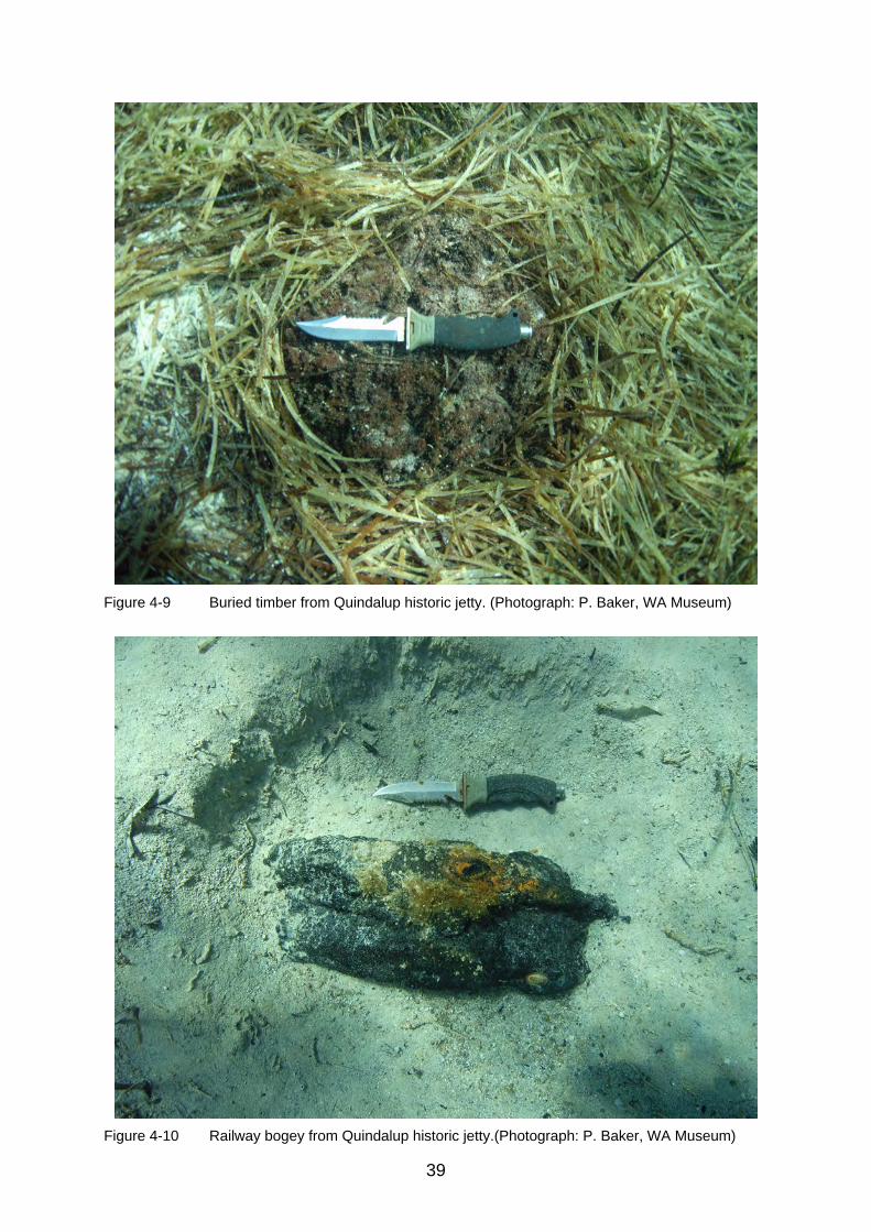
Features observed on the Quindalup jetty underwater site were (Figs. 4-5 to 4-11):
1. Broken length of railway iron with total length of 4 metres (Fig. 4-5); 2. Eroded jetty pile measuring 35 centimetres in diameter; 3. Collapsed structural timber; 4. Railway wheels (bogey), six spokes, length of axle 1.25 metres,
wheel diameter 76 centimetres (Figs 4-6 to 4-8); 5. Buried timber (Fig. 4-9); 6. Another railway bogey mostly buried (Fig. 4-10); 7. A mooring with chain in the vicinity, possibly attached to this bogey.
The features were clustered predominantly in a discrete area in a sandy clearing amongst dense seagrass, in 2.5 metres depth, approximately 80 metres northwest of the boat ramp jetty. GPS positions are:
1. Service jetty pile on shoreline: S 33.63145º, E 115.14887º 2. Railway bogey (feature 6): S 33.63030º, E 115.14866º

37
Figure 4-5 Railway iron of Quindalup historic jetty. (Photograph: P. Baker, WA Museum)
Figure 4-6 Railway wheels from Quindalup historic jetty. (Photograph: P. Baker, WA Museum)

38
Figure 4-7 Close-up of bogey from Quindalup historic jetty. (Photograph: P. Baker, WA Museum)
Figure 4-8 Side view of bogey from Quindalup historic jetty. (Photograph: P. Baker, WA Museum)
39
Figure 4-9 Buried timber from Quindalup historic jetty. (Photograph: P. Baker, WA Museum)
Figure 4-10 Railway bogey from Quindalup historic jetty.(Photograph: P. Baker, WA Museum)

40
Figure 4-11 Thick sea grass covering Quindalup historic jetty remains.
(Photograph: P. Baker, WA Museum)
Surface tape measurements were made between the main features, as the team was snorkelling. No other artefacts were noted. Underwater visibility was clear, but the dense seagrass in this area obscures any features on the seabed, other than those described that lay within open patches of sand (Fig. 4-11).

41
5. QUINDALUP REMOTE SENSING SURVEY
By Jeremy Green Introduction
It is known from historical records that the American whaler Geffrard was lost on 12 June 1875 not far from the Quindalup jetty. Archdeacon’s 1876 map of the area marks a wreck to the northeast of the Quindalup jetty (Fig. 5-1). The map was geo-referenced and overlaid onto an aerial photograph, with the wreck site indicated by Archdeacon marked.
Figure 5-1 The location of the Geffrard shipwreck on Archdeacon’s 1876 map—geo-referenced
and superimposed over aerial photograph of the Quindalup survey area. (ArchGIS: J. Green, WA Museum)
The survey
Survey coordinates were determined to ensure a reasonable chance of locating the site, assuming that the vessel was most likely buried, or at least partially buried. Since the wreckage should include some iron fittings and fastenings, and since the water depth in the general area is only a few metres, it was decided that a magnetometer survey would have a better chance of locating the site than one using side-scan sonar. In the end, however, both systems were available so it was decided to deploy them both (Figs. 5-2 and 5-3).

42
Figure 5-2 Magnetometer data of the survey at Quindalup showing the survey lanes in search of
the whaler shipwreck. The purple dots indicate the boat’s survey track, while the two large contour anomalies in red are the jetty and an unknown site. (ArchGIS: J. Green, WA Museum)
Figure 5-3 Side-scan sonar survey in the area of the Geffrard shipwreck. (ArchGIS: J. Green, WA
Museum)

43
Weather conditions on the day were ideal, with little wind-blown waves that would affect the sonar, and no thunderstorm activity that would affect the magnetometer. The survey utilised east-west lanes with spacing of about 50 metres, running from about 115.15°E to 115.16°E and 33.632°S to 33.626°S (Fig. 5-2). During the survey, anomalies were noticed in the south-eastern quadrant. At the end of the survey, the team made a visual inspection of the general area where the anomaly was located, but found nothing of interest. The side-scan sonar survey showed nothing of interest, except for unusual sea grass beds over the whole area (Fig. 5-3). When the magnetic data was processed after the survey, it was clear that the indications of the magnetic survey were correct and that essentially there was a large magnetic anomaly about 500 metres south of the position calculated from the 1876 Archdeacon map. In addition, there was a considerable magnetic anomaly around the modern jetty. No magnetic or side-scan sonar work was conducted around the old jetty site. Conclusions It seems quite likely that the magnetic anomaly is a shipwreck site of some sort, probably that of Geffrard. Since there is no visual evidence of a shipwreck on the surface, it is likely to be buried, although not too deep. It is recommended to conduct a close-plot magnetometer survey in the area to establish the precise location of the site. It would then be necessary to excavate some trenches across the site with a water dredge to determine the nature of the anomaly.

44
6. BUSSELTON JETTY: ON-SITE CONSERVATION SURVEY REPORT
By Vicki Richards
Site location and survey The ALA Fellowship programme concluded with an expedition to Western Australia’s southwest coast (25–28 February 2009), which included a practical training session in on-site conservation survey techniques on the Busselton jetty for the visiting fellows. The Busselton Jetty is located in Geographe Bay, a wide, open, north facing embayment situated between Cape Bouvard and Cape Naturaliste on the south-west coast of Western Australia. It is a relatively protected and shallow bay. Water movement in Geographe Bay is mainly wind driven. Geographe Bay has a relatively short flushing period of 3–15 days dependent on the wind direction and is, therefore, a well-mixed system.
Figure 6-1 Busselton jetty, Busselton, WA. (Google Earth 2009)

45
Figure 6-2 Visitors inside the Underwater Observatory. (Photograph: R. Anderson, WA Museum)
Figure 6-3 The approximate position of the survey area adjacent to the Underwater Observatory,
Busselton jetty. (Google Earth 2009)
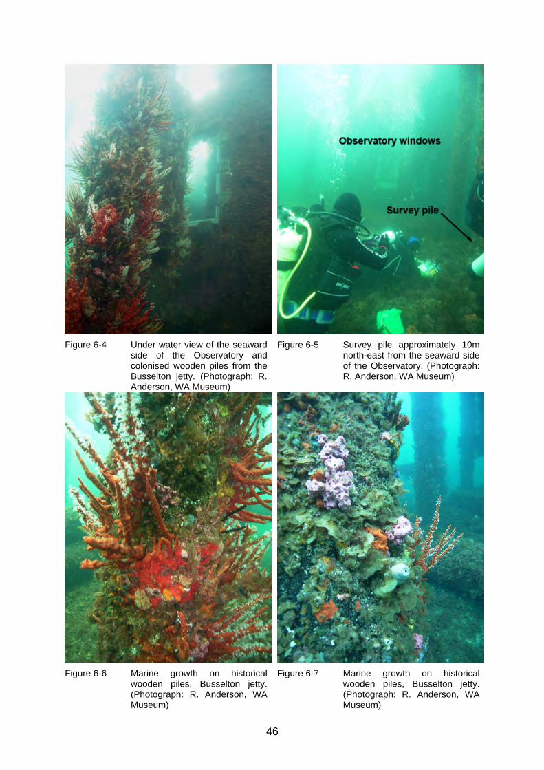
46
Figure 6-4 Under water view of the seaward side of the Observatory and colonised wooden piles from the Busselton jetty. (Photograph: R. Anderson, WA Museum)
Figure 6-5 Survey pile approximately 10m north-east from the seaward side of the Observatory. (Photograph: R. Anderson, WA Museum)
Figure 6-6 Marine growth on historical wooden piles, Busselton jetty. (Photograph: R. Anderson, WA Museum)
Figure 6-7 Marine growth on historical wooden piles, Busselton jetty. (Photograph: R. Anderson, WA Museum)

47
The Busselton jetty survey site was adjacent to the Underwater Observatory (33° 37.790´S; 115° 20.284´E), located approximately 1.8 kilometres from the shore-end of the jetty (Figs. 3-1 and 6-1). As discussed in chapter 3, construction of the Busselton jetty commenced in 1853, thus at the time of the survey, the jetty was 156 years old. However, due to continuous in-shore sediment accretion, causing the area to become too shallow for ship access, numerous extensions were added to the jetty from 1872, continuing until the final extension was completed in 1960. The Underwater Observatory descends 8 metres from the seawater surface and can accommodate up to 40 visitors at one time. There are eleven viewing windows located at various levels within a 9.5-metre diameter observation chamber (Figs. 6-2 and 6-4). The approximate position of the survey area was about 10 metres north-east from the seaward side of the Underwater Observatory (Figs. 6-3 and 6-5). The on-site conservation survey included physico-chemical measurements and visual observations of the seawater and sediment column, corrosion parameter measurements of an iron artefact and pH profiles, maximum water contents and wood identification of a wooden pile. The results of this survey are summarised below. The seabed in the vicinity of the survey site was relatively level and comprised of loosely packed, very coarse-grained calcareous sand with little organic detritus on the sediment surface. The pH of the surface sediment was similar to that of the immediate water column, indicating mobile sediment and irregular packing of the coarse-grained sand, which allows the passage of seawater through the sediment. However, from the physico-chemical measurements and visual observations of the sediment core sample, the depth to stable sediment was approximately 7–9 centimetres and materials buried below this zero-Eh interface would be subjected to less deterioration than those artefacts present in the more oxidising, upper 7 centimetres of the sediment column. Other than the heavily colonised jarrah jetty piles, there were very few historical artefacts observed in the survey area, with the exception of a large anchor and some iron bollards. The corrosion parameters measured on an iron bollard indicated that it was actively corroding, but the relatively thin concretion and corrosion layer would suggest that the bollard had not been subjected to this oxidising marine environment for an extended period of time. The pH profiles and the maximum water contents indicate that the survey pile, despite having some superficial marine worm damage, is in excellent condition and possesses a relatively thin degraded outer layer (<20 mm) overlying an extensively non-degraded inner core. Hence, based on the fact that the iron bollard and survey pile were in relatively good condition, it can be assumed safely that this section of the jetty is part of the more contemporary extensions carried out in the mid 1900s. Date of inspection: 26 February 2009 Personnel Vicki Richards (conservation scientist) Jon Carpenter (on-site conservator) Worrawit Hassapak (ALA fellow) Chandraratne Wijamunige (ALA fellow) Ross Anderson (photography) Dive times for conservation staff are reproduced in Appendix A.

48
Weather and sea conditions The weather was overcast in the early morning, but the cloud cover dissipated by mid morning, resulting in fine weather for the remainder of the day. There was a slight to moderate (10–15 knots) south-westerly wind in the morning increasing steadily as the day progressed (http://www.buoyweather.com). Sea conditions adjacent to the jetty were calm with minimal swell. There was no discernible current. The tide was semi-diurnal (Table 6-1) with the first high tide stand being approached during the survey period.
26 February 2009
Height (m) Time
0.35 4:27 0.68 11:16 0.48 16:03 0.72 20:18
Table 6-1 Tidal predictions for Bunbury, WA (http://www.dpi.wa.gov.au/imarine/19102.asp)
The temperature of the sea directly under the Underwater Observatory has been monitored hourly since February 2001 as part of an on-going research programme to monitor environmental conditions in the Busselton town jetty area. The temperature logger is mounted on a jetty pile five metres above the seabed. The results have shown the typical seasonal patterns in southern Geographe Bay: the average summer water temperature is 21.6°C in February/March, decreasing to 15.0°C in July for an annual range of 6.6°C (http://www.busseltonjetty.com.au). The water temperature measured during the February conservation survey was 22°C. There was no significant temperature gradient throughout the water column (0–8.5 m). The through-water visibility was about 5–10 metres. The average pH of the seawater at the seabed surface (8 m) was 7.97±0.01 and the average redox potential was 0.214±0.009V, indicative of a typical open circulation, oxygenated saline environment. The salinity and dissolved oxygen content of the water column were not measured at the time of the survey. Description
General observations
The Busselton jetty was built from jarrah wood in 1853 and extended numerous times between 1872 and 1960. The jetty was closed to commercial shipping in 1972 and faced demolition. However, with local community and Busselton shire support, the jetty was saved and partly restored with ongoing maintenance a priority. With the opening of the Interpretation Centre in 2001 and the Underwater Observatory in 2003, the Busselton jetty became one of the Southwest’s premier tourist attractions. Geographe Bay is a relatively pristine marine embayment fed by the warm Leeuwin current. The mixing of this current with cooler Indian Ocean currents is responsible for the success of Busselton jetty as an artificial reef; the rich and abundant sealife that it supports makes it one of the top ten dive sites in WA. An incredibly diverse array of tropical and sub-tropical species have been introduced into Geographe Bay. Sessile invertebrates, such as sponges, tunicates bryozoans and ascidians, flowering soft corals, especially Telesto corals, hydroids and algal

49
forms have colonised the jetty piles (Figs. 6-6 and 6-7). There was a large variety of higher vertebrates present on the site as well, with the team observing boxfish, buffalo bream, bulleyes, herring, hulafish, leatherjackets, morwongs, blackheaded pullers, samson fish, yellow tailed scads, sweep, trevally, wrasse and other fish species. Geographe Bay has a temperate, Mediterranean type climate characterised by warm, dry summers and cool, wet winters (Walters, 1979). The annual rainfall is 800 millimetres with 85% of the rain falling between May and October (Fahrner & Pattiaratchi, 1995). There are a number of brooks, rivers, river drains and estuaries that discharge into Geographe Bay. Without measuring the salinity on the survey site, it is difficult to ascertain if there is any fresh water influence, however, it is likely that any such effect would be minimal during the summer season. The jetty is aligned in a roughly north-south direction (Fig. 6-1) and has a gentle sloping bathymetry towards the north, with the depth to the seabed at the survey site about 8 metres. The survey site was relatively level, comprised of coarse grain calcareous sand with little organic detritus and epiphytes on the seabed surface. There are extensive seagrass beds throughout the bay, but there are no sea grass beds or reefs in close proximity to the survey site. Degree of site exposure
The jetty piles were driven about 4 metres into the seabed and extended approximately 2–3 metres above the seawater surface. Other historical and contemporary materials were exposed on the seabed surface.
Figure 6-8 Anchor on the survey site, Busselton jetty. (Photograph: R. Anderson, WA Museum)

50
Seasonal exposure
The site appeared to be reasonably stable with no evidence of seasonal exposure at the time of the survey. Human disturbance
The historical association of the jetty with the Busselton Township has resulted in an accumulation of cultural and modern material on the site. However, there were very few historical artefacts observed in the survey area, with the exception of a large anchor (Fig. 6-8) and some large iron bollards. Conservation survey results: Metal survey Ferrous Materials
Conservation staff measured the corrosion parameters of an iron bollard (Position 1: VR & JC), and then similar measurements were repeated by the ALA Fellows in an adjacent area (Position 2: WH & CW). The results are presented in Table 6-2. Description pH Corrosion
potential (rel. NHE) (V)
Depth of concretion +
graphitisation (mm)
Water depth
(m)
Bollard: Position 1 (VR & JC) 6.61 -0.357 7 7.9 Bollard: Position 2 (WH & CW) 7.20 -0.357 9 7.9
Table 6-2 Corrosion parameters of the iron bollard on the Busselton jetty site. The concretion acts as a semi-permeable layer on the surface of the iron, effectively separating the anodic and cathodic sites and producing an acidic, iron and chloride rich microenvironment at the residual iron surface. Hence, the pH of the residual metal surface of actively corroding iron should decrease as corrosion proceeds. It is important to note that the surface pHs measured by both teams were different, although the corrosion potentials were the same. This is simply explained by the fact that the second team (ALA Fellows) was less experienced than the conservation staff and more seawater penetrated the drill hole, concomitantly increasing the final pH measurement recorded. By plotting the measured voltages and the corresponding surface pH on the Pourbaix diagram for iron at 10-6M in aerobic seawater at 25ºC, the thermodynamic stable state of the iron can be ascertained (Fig. 6-9). Both sets of measurements of the iron bollard on the Busselton jetty indicate that it was actively corroding. This would suggest that other ferrous materials, such as the anchor, would also be actively corroding. It is important to note that Pourbaix diagrams do not include kinetic information. They are only thermodynamic stability maps that indicate the corrosion mechanisms, but not the corrosion rate. However, they can be used as a general guide for interpretating corrosion data. The iron bollard used in the corrosion survey was covered with thin concretion, lightly encrusted with secondary marine growth (Fig. 6-10). Iron is not biologically toxic and increases the growth rate of encrusting organisms. The relatively thin concretion and corrosion layer (7–9mm) suggest that the bollard has not been subjected to aggressive environmental conditions, although the corrosion parameters indicate that it is actively corroding. The smaller depth of penetration could also suggest that the bollard has not been exposed to this oxidising marine environment for an extended
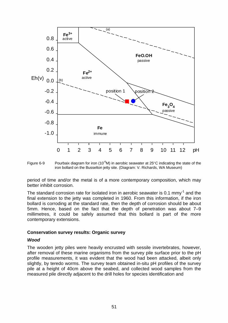
51
0 1 2 3 4 5 6 7 8 9 10 11 12 pH
Eh(v)
0.8
0.6
0.4
0.2
0.0
-0.2
-0.4
-0.6
-0.8
-1.0
Fe2+
Fe3O
4
Fe
FeO.OH
Fe3+
active
passive
active
passive
immune
(b)
(a)
position 1 position 2
Figure 6-9 Pourbaix diagram for iron (10-6M) in aerobic seawater at 25C indicating the state of the iron bollard on the Busselton jetty site. (Diagram: V. Richards, WA Museum)
period of time and/or the metal is of a more contemporary composition, which may better inhibit corrosion. The standard corrosion rate for isolated iron in aerobic seawater is 0.1 mmy-1 and the final extension to the jetty was completed in 1960. From this information, if the iron bollard is corroding at the standard rate, then the depth of corrosion should be about 5mm. Hence, based on the fact that the depth of penetration was about 7–9 millimetres, it could be safely assumed that this bollard is part of the more contemporary extensions. Conservation survey results: Organic survey Wood
The wooden jetty piles were heavily encrusted with sessile invertebrates, however, after removal of these marine organisms from the survey pile surface prior to the pH profile measurements, it was evident that the wood had been attacked, albeit only slightly, by teredo worms. The survey team obtained in-situ pH profiles of the survey pile at a height of 40cm above the seabed, and collected wood samples from the measured pile directly adjacent to the drill holes for species identification and

52
Figure 6-10 Iron bollard used for the corrosion survey, Busselton jetty.
(Photograph: R. Anderson, WA Museum) maximum water content (Umax) determination (Fig. 6-11). Again, the first pH profile was measured by conservation staff (Position 1: VR & JC) and an adjacent area subsequently measured by the ALA Fellows (Position 2: WH & CW). The results of the pH profiles are presented in Table 6-3 and shown diagrammatically in Figure 6-12.
Description Depth of penetration (mm) pH measurement
Survey pile: position 1 (VR & JC)
0 7.41 8 7.35 17 7.66 29 6.11
Survey pile: position 2 (WH & CW)
3 7.97 3 7.98 13 7.25
Table 6-3 Results of the pH profiles on the survey pile from the Busselton jetty.

53
Figure 6-11 ALA fellows taking core samples from wooden pylons of the Busselton jetty.
(Photograph: R. Anderson, WA Museum) Wood is degraded in the marine environment by physical (water movement, sand impingement), chemical (chemical reactions in the wood and hydrolysis reactions with sea water) and biological (marine borers, fungi and bacteria) processes. Degradation commences on the exposed surface, but, under the right environmental conditions, will continue into the wood until it is totally destroyed. As the wood deteriorates, there is an increase in the accessibility and size of the pore spaces through which alkaline seawater can penetrate into the wood structure. Therefore, in general, the plots of pH versus depth of penetration follow a typical sigmoidal relationship. That is, the pH of the wood near the surface is high then as the depth into the timber increases there is a sharp and rapid decrease in pH that tends to plateau with increasing core depth. The higher pH measured on the wood surface, slightly more acidic than seawater, is indicative of the pH being controlled by the buffering capacity of the sea water. More importantly, this maximum pH denotes the area of greatest deterioration. Degradation occurs from the outer, more exposed areas in the initial instance. Hence, the normally acidic nature of the wood becomes progressively more alkaline with increasing degradation due to the inward diffusion of seawater.

54
pH Profile of Jetty Pile
6.00
6.20
6.40
6.60
6.80
7.00
7.20
7.40
7.60
7.80
8.00
0 5 10 15 20 25 30
Depth of penetration (mm)
pH Position 1
Position 2
Figure 6-12 pH profiles of the wooden pile measured on the Busselton jetty.
(Graph: V. Richards, WA Museum) Typically, pH decreases rapidly as the core depth increases, indicating a decrease in the extent of degradation. The pH will eventually reach a minimum that denotes the area of least deterioration where the wood is least waterlogged. The overall decrease in pH of the wood core is an indication of the inherent acidity of wood. The innermost wood is still waterlogged, albeit to a lesser extent than the outer surfaces, therefore the pH will be more alkaline than the standard pH of seasoned, modern, non-degraded wood of the same species. The pH profiles for the wooden pile on the Busselton jetty are typical of wood with a relatively thin outer layer (<20 mm) of degraded wood overlying an extensive non-degraded inner core in excellent condition. Hence, if the estimated diameter of the survey pile is about 300 millimetres, then this pile has less than 10% total deterioration. This may suggest that the pile has not been exposed to the marine environment for an extended period of time and that it is likely to be part of the more recent extensions to the jetty in the mid 1900s. One important point to note is the second pH profile (position 2) measured by the ALA fellows was outside the typically acceptable reproducibility range of 5% of the mean pH value for each depth interval. This highlights the fact that, in order to obtain reasonably consistent results, the operators must have extensive experience in this measurement procedure. Maximum moisture content is an easily measured quantity which may be related to specific gravity and thus to the extent of degradation of the wood. It is universally used as an indicator of wood deterioration and is the basis of a classification scheme. Waterlogged timbers may be classified as follows: Class I (>400%)—an extremely degraded, extensive outer surface with very little solid core; Class II (185–400%)—a degraded outer surface with a thin, partially degraded area and a considerably larger solid core; Class III (<185%)—a very thin degraded outer surface layer overlying an extensive, non-degraded core (Pearson 1987). Core sample 8, collected adjacent to pH profile measurement position 1, was 21 millimetres thick and possessed a very soft degraded surface (3 mm), beyond which

55
the wood was in relatively good condition, although there was evidence of teredo damage throughout the core’s entire length. Core sample 9, collected near measurement position 2, was 12 millimetres thick and exhibited a less degraded surface (2 mm) than the first sample, with no evidence of biological attack. The maximum water contents of these wood core samples were 86% and 80%, respectively, indicating that the wooden pile is Class III, which is in good agreement with the results obtained from the pH profiles. The pile was tentatively identified as a Eucalyptus species, most probably jarrah (pers. comm. Godfrey 4 May 2009). Eucalypt species are often used as jetty piles because of their durability in the marine environment, especially in the cooler waters of the southwest coast of WA.
Figure 6-13 Sediment core sample (BTJ 43) from the Busselton jetty survey site.
(Photograph: V. Richards, WA Museum)
56
Sediment
The pH of the sediment at a depth of 30 millimetres was 7.79. This pH, indicative of the surface sediment, is slightly more acidic than the surrounding aerobic seawater (7.97av), which is to be expected due to the oxidation of organic detritus by aerobic and facultative bacteria producing acidic metabolites and by-products. However, this pH difference is not particularly significant and there was very little organic detritus observed on the seabed, which could explain the relatively higher pH of the surface sediment due to less aerobic oxidation of organic material. In addition, due to the more open packing of the coarser grained surface sand, seawater could have more easily penetrated the surface layers, effectively increasing the pH of the interstitial water to a greater depth than would normally be expected for sediments of finer particle sizes. The redox potential of the sediment at 90 millimetres was -0.058V, indicating that the sediment is neither oxidising nor reducing in nature at this depth. These redox potential and the pH measurements indicate that the zero-Eh interface lies at a depth of about 8–9 centimetres under the seawater/sediment interface. This implies that the overlying sediment above this depth is more alkaline and oxidising in nature. One sediment core sample was collected approximately 10 metres east of the survey pile at a water depth of 8.2 metres. The total length of the core sample (BTJ 43) was only 94 millimetres because the coarser grain sand made it difficult to penetrate the sediment column to the full extent of the polycarbonate corer (300 mm). The core sample revealed a thin layer (13 mm) of red/brown very coarse-grained sand overlying 57 millimetres of red/grey coarse-grained sand. Below this depth (>70 mm) the particle size of the sediment decreased and possessed the typical grey to black discolouration, indicating an anaerobic environment that extended to the base of the core sample (70–94 mm) (Fig. 6-13). This implies that the depth to stable sediment is approximately 7–8 centimetres, which supports the electrochemical measurements that indicated that the zero-Eh interface also occurred at about this depth. It is important to note that when the sediment was first recovered, the upper sediment layers were white to grey in colour, but slowly turned red/brown over a period of a few weeks with the oxidation of the reduced iron species in the sediment. Hence, in order to avoid possible misinterpretation of the sediment data, the core samples should be photographed as soon as possible after recovery. The results of the sediment survey indicate that the sand in the upper 8 centimetres of the sediment column is relatively coarse, well oxygenated and thus, more oxidising in nature. After this depth, however, the particle size decreases and the sediment becomes more stable, anoxic and therefore, more reducing in nature. The conservation implications of these observations is that artefacts in the upper sediment layers would be subject to more deterioration than those materials buried at depths greater than about 10 centimetres in this survey area. Discussion
The Busselton jetty site is an open circulation, oxidising marine environment, typical of the Geographe Bay area. The jetty has a gentle sloping bathymetry towards the north with the depth to the seabed at the survey site about 8m. The seabed in the vicinity of the survey site was relatively level and comprised of loosely packed, very coarse-grained calcareous sand with little organic detritus on the sediment surface. The pH of the surface sediment was similar to that of the immediate water column, further indicative of mobile sediment and irregular packing of the coarse grained sand, allowing the passage of seawater through the sediment. However, physico-chemical
57
measurements and visual observations of the sediment core sample indicate that the depth to stable sediment was approximately 7–9 centimetres and materials buried below this zero-Eh interface would be subjected to less deterioration than those artefacts present in the more oxidising, upper 7 centimetres of the sediment column. Other than the heavily colonised jarrah jetty piles, a large anchor and some iron bollards were the only historical artefacts observed in the survey area. The corrosion parameters measured on an iron bollard indicate that it is actively corroding, but the relatively thin concretion and corrosion layer suggest that the bollard has not been subjected to this oxidising marine environment for an extended period of time. The pH profiles and the maximum water contents indicated that the survey pile, despite having some superficial marine worm damage, is in excellent condition. It possesses a relatively thin degraded outer layer (<20 mm) overlying an extensively non-degraded inner core. Based on the conditions of the iron bollard and survey pile, it can be safely assumed that this section of the jetty is part of the more contemporary extensions carried out in the mid 1900s.
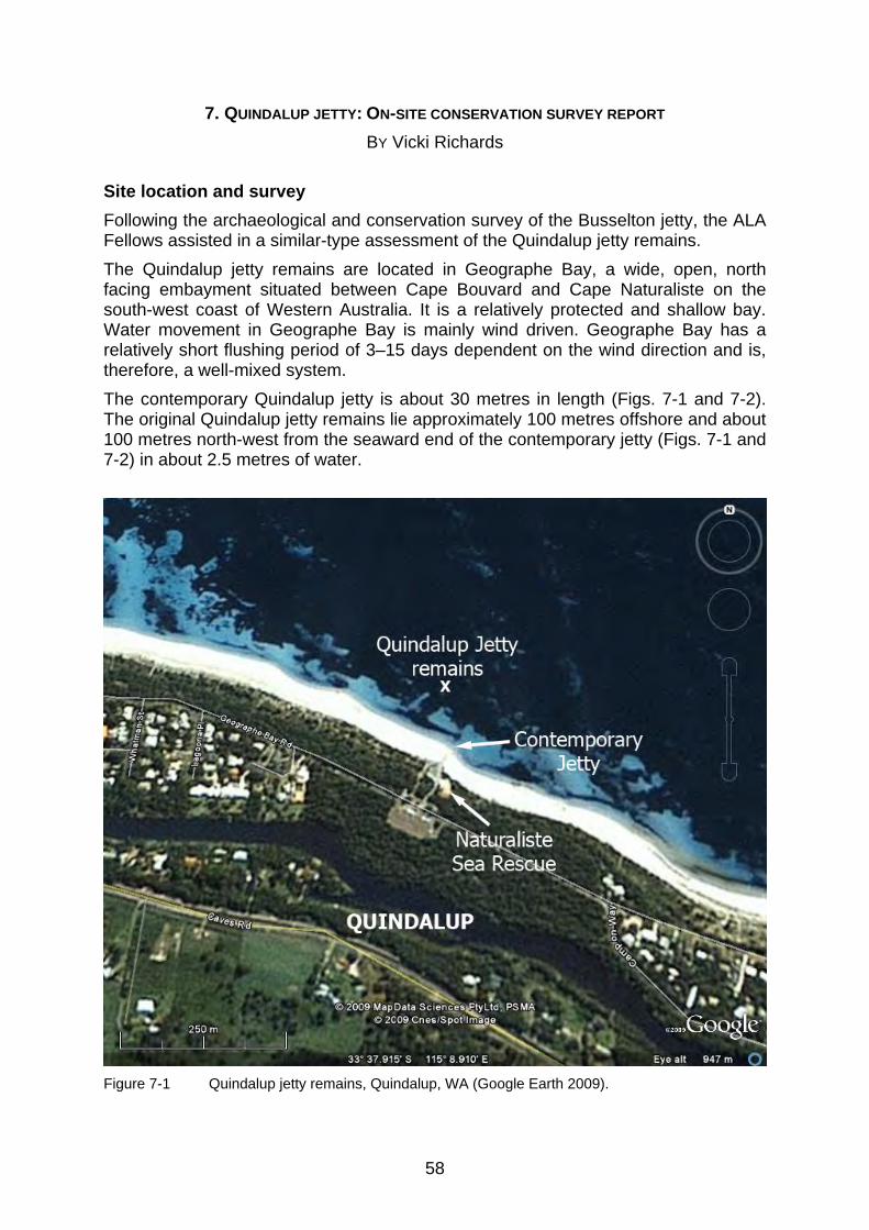
58
7. QUINDALUP JETTY: ON-SITE CONSERVATION SURVEY REPORT
BY Vicki Richards Site location and survey Following the archaeological and conservation survey of the Busselton jetty, the ALA Fellows assisted in a similar-type assessment of the Quindalup jetty remains. The Quindalup jetty remains are located in Geographe Bay, a wide, open, north facing embayment situated between Cape Bouvard and Cape Naturaliste on the south-west coast of Western Australia. It is a relatively protected and shallow bay. Water movement in Geographe Bay is mainly wind driven. Geographe Bay has a relatively short flushing period of 3–15 days dependent on the wind direction and is, therefore, a well-mixed system. The contemporary Quindalup jetty is about 30 metres in length (Figs. 7-1 and 7-2). The original Quindalup jetty remains lie approximately 100 metres offshore and about 100 metres north-west from the seaward end of the contemporary jetty (Figs. 7-1 and 7-2) in about 2.5 metres of water.
Figure 7-1 Quindalup jetty remains, Quindalup, WA (Google Earth 2009).

59
Figure 7-2 The Quindalup jetty site, Quindalup, WA. (Photograph: P. Baker, WA Museum)
As discussed in Chapter 3, the Quindalup jetty was constructed in 1855 (Garratt, 1993b), and thus it is possible that some of the jetty remains, especially the jetty piles, were 154 years old at the time of the 2009 survey. The exposed jetty remains are aligned on a roughly north-south transit, covering an area approximately 10 metres2 and consisting of a few iron wheels and jetty pile remains and an iron railway track. The on-site conservation survey included physico-chemical measurements and visual observations of the seawater and sediment column, corrosion parameter measurements of the iron artefacts on-site and pH profiles, maximum water contents and species identification of some wooden jetty pile remains. The surrounding shoreline near the Quindalup jetty has a gentle sloping bathymetry towards the north. The seabed in the survey area is relatively level and comprised of fine-grained calcareous sand with little organic detritus and epiphytes evident on the seabed surface, with the exception of dead seagrass fronds. There are extensive seagrass beds surrounding the survey area, however there was some scouring of the seagrass in close proximity to the exposed iron wheels, probably caused by the contemporary mooring located on-site. The sediment survey indicates that the sand in the upper 10 centimetres of the sediment column is fine-grained, relatively oxygenated and, thus, more oxidising in nature, containing appreciable quantities of organic material to support bacterial activity. However, beyond this depth the sediment became more stable, less oxygenated and, therefore, more reducing in nature with considerably less organic content. The conservation implication of these observations is that artefacts in the

60
upper sediment layers would be subjected to more deterioration than those materials buried at depths greater than about 10 centimetres on this site. The corrosion survey indicates that all ferrous artefacts on the Quindalup jetty site are actively corroding; however the buried iron artefacts are in better condition than those materials constantly exposed to the aerobic marine environment. The corrosion survey of the exposed iron bogey suggests that it was part of the original Quindalup jetty and has been exposed for a considerable period of time (Fig. 7-3). There is also some evidence of recent exposure of the iron track, indicating that some sediment movement does occur on the site, however, the overall amount of sediment movement is minimal.
Figure 7-3 Conservation staff measuring corrosion parameters on an iron wheel on the
Quindalup jetty, WA. (photograph: P. Baker, WA Museum) Exposed jetty pile remains are covered with algal mats, with very few higher marine organisms evident on the surfaces, but exhibit extensive marine borer damage. The pH profiles for the exposed Jetty Pile 1 and the buried jetty pile are typical of wood with a relatively thin outer layer (<20 mm) of extensively degraded wood overlying a less degraded inner core. However, the more acidic pH measurements noted for the buried jetty pile after a depth of about 50 mm indicate that the inner region of this pile is in better condition than the exposed pile. This is not unexpected, as it is well known that wood recovered from deoxygenated environments is usually better preserved than wood exposed to an aerobic environment, because the wood is largely protected from ongoing extensive physical and biological deterioration.

61
Date of inspection: 26 February 2009 Personnel Vicki Richards (conservation scientist) Jon Carpenter (on-site conservator) Worrawit Hassapak (ALA fellow) Chandraratne Wijamunige (ALA fellow) Ross Anderson (archaeologist) Wendy van Duivenvoorde (archaeologist) Patrick Baker (photographer) Dive times for conservation staff are reproduced in Appendix B. Weather and sea conditions The survey weather was fine, with a slight to moderate (10–15 knots) south-westerly wind in the morning increasing steadily as the day progressed (http://www.buoyweather.com). Sea conditions adjacent to the jetty were calm with minimal swell. There was no discernible current. The tide was semi-diurnal (Table 7-1) with the first high tide stand (0.95 m @ 11:37) being approached during the survey period.
27 February 2009 Height (m) Time
0.60 4:45 0.95 11:37 0.69 16:56 0.86 23:03
Table 7-1 Tidal predictions for Bunbury, WA. (http://www.dpi.wa.gov.au/imarine/19102.asp) The through-water visibility was about 5–10 metres. The average pH of the seawater at the seabed surface (2.4 m) was 8.34 ± 0.01 and the redox potential was 0.164V. The water temperature measured at the seabed surface (2.4 m) was 22°C. The temperature, salinity and dissolved oxygen content (compensated for salinity) of the water column was measured at 0.5 metres intervals directly adjacent to the seaward end of the contemporary jetty, approximately 100 metres southeast of the historic jetty site. The results are shown in Table 7-2.
Water depth (m) Dissolved oxygen (ppm(S)) Salinity (ppK) Temperature (°C) 0.0 5.76 37.4 21.9 0.5 5.71 37.4 21.9 1.0 5.59 37.4 21.9 1.5 5.52 37.4 21.9 average 5.65 ± 0.11 37.4 ± 0.0 21.9 ± 0.0
Table 7-2 Temperature, salinity and dissolved oxygen content of the water column on the Quindalup jetty site. The temperature of the sea under the seaward end of the Busselton jetty has been monitored hourly since February 2001 as part of an on-going research programme to monitor environmental conditions in the Busselton town jetty area. The results have shown the typical seasonal patterns in southern Geographe Bay. The average

62
Change in Dissolved Oxygen with Depth
y = -0.168x + 5.771R2 = 0.9773
5.50
5.55
5.60
5.65
5.70
5.75
5.80
0.0 0.5 1.0 1.5
Water Depth (m)
Dis
so
lved
Ox
ygen
Co
nc
entr
ati
on
(p
pm
S)
Figure 7-4 Change in dissolved oxygen concentration with increasing water depth on the
Quindalup jetty site. (Graph: V. Richards, WA Museum) summer water temperature is 21.6°C in February/March, decreasing to 15.0°C in July, for an annual range of 6.6°C (http://www.busseltonjetty.com.au). The average water temperature measured during the February conservation survey on the Quindalup jetty remains was 21.9 ± 0.0°C, which is in good agreement with the average summer water temperature (21.6°C) measured at the Busselton jetty, 18km south of Quindalup township. There was no significant temperature gradient through the water column (0–1.5 m). The average salinity of the water column on-site was 37.4 ± 0.0ppK. There was no significant change in salinity with depth. The usual salinity range for the open ocean is 32–37ppK. The average dissolved oxygen concentration was 5.65 ± 0.11ppm. The change in dissolved oxygen concentration with increasing water depth is shown graphically in Figure 7-4. The dissolved oxygen concentration of the water column on the Quindalup jetty site decreased, albeit only slightly, with increasing water depth. Factors contributing to this trend are decreasing water movement, which leads to less oxygen exchange with the atmosphere and decreasing photosynthetic activity due to less light penetration, with increasing water depth. However the overall decrease in dissolved oxygen content is relatively insignificant over this small depth range, so the usual beneficial effects on material degradation would be minimal. This general decreasing trend and the other physico-chemical measurements outlined above are typical for an open circulation, well-oxygenated marine environment. Description
General observations
Constructed in 1855 (Garratt 1993b), it is possible that some of the jetty remains, especially the jetty piles, were 154 years old at the time of the survey. The exposed jetty remains, comprised of a few iron wheels and jetty pile remains (Fig. 7-5) and an iron railway track (Fig. 7-6), are aligned on a roughly north-south transect spread over an area approximately 10 metres2 and about 2.5 metres deep.

63
Figure 7-5 Two iron wheels and the remains of one jetty pile. (Photograph: P. Baker, WA Museum)
Figure 7-6 The remains of an iron track. (Photograph: P. Baker, WA Museum)
The exposed concreted surfaces of the iron structures were sparsely covered with sessile marine organisms including bryozoans, sponges, ascidians and tunicates. In less concentrated areas of growth, algal forms were present (Fig. 7-7). Exposed jetty pile remains were covered with algal mats, with very few higher marine organisms evident on the surfaces, but exhibited extensive marine borer damage (Fig. 7-8). The surrounding shoreline has a gentle sloping bathymetry towards the north. The survey area was relatively level, comprising of medium to fine grain calcareous sand with little organic detritus and epiphytes evident on the seabed surface, with the exception of dead seagrass fronds (Fig. 7-9). There are extensive seagrass beds surrounding the survey area (Figs. 7-5 and 7-6), however, it appears that there has been some scouring of the seagrass in close proximity to the remains, especially in the area where the iron wheels were situated (Fig. 7-10). Geographe Bay has a temperate, Mediterranean-type climate characterised by warm, dry summers and cool, wet winters (Walters, 1979). The annual rainfall is 800mm, with 85% of the rain falling between May and October (Fahrner & Pattiaratchi, 1995: 3–12). There are a number of brooks, rivers, river drains and estuaries that discharge into Geographe Bay. However, based on the salinity measurements taken near the survey site (Table 7-2), any fresh water influence is negligible, as would be expected during the summer months. Degree of site exposure
The most exposed artefacts were the partially buried iron wheels rising about 0.3 metre above the sediment on the north end of the site (Fig. 7-5). One jetty pile only just protruded through the sediment surface, whilst another jetty pile lay horizontally

64
on the seabed. Active marine borer damage was observed on all piles (Fig. 7-5). The iron track was also exposed in parts, in some places lying directly on the sediment surface (Fig. 7-6) while elsewhere lying buried just beneath the sediment surface. One iron wheel was almost totally buried with only a very small portion exposed, as evident from the seaweed and algal growth on the very top surface (Fig. 7-11).
Figure 7-7 Concreted surfaces of an iron railway wheel. (Photograph: P. Baker, WA Museum)
Figure 7-8 Degradation of a jetty pile by marine borers. (Photograph: P. Baker, WA Museum)
Figure 7-9 Survey area seabed with dead seagrass. (Photograph: P. Baker, WA Museum)
Figure 7-10 Scouring of the seagrass around the iron wheels. (Photograph: P. Baker, WA Museum)
Seasonal exposure
A jetty pile buried to a depth of about 20 centimetres was excavated just north-east of the pair of railway wheels. There was evidence of previous biological deterioration by marine borers, but it is impossible to determine when this degradation occurred (Fig. 7-12). More importantly, the concretion and the extent of biological growth on the exposed parts of the iron wheels suggest that these artefacts have been exposed to an aerobic marine environment for a considerable period of time, and there was no evidence of seasonal reburial/exposure cycles at the sediment/seawater interface. In addition, the rod connecting the two wheels was buried just under the sediment surface and there was no evidence of previous exposure to an aerobic marine environment. Furthermore excavation of the almost totally buried iron wheel revealed the typical black, dense concretion common to anaerobically corroded ferrous

65
Figure 7-11 Buried iron wheel. (Photograph: P. Baker, WA Museum)
Figure 7-12 Buried jetty pile remains with evidence of previous marine borer damage.
(Photograph: P. Baker, WA Museum)

66
Figure 7-13 Mooring post with chain located on the Quindalup jetty site. (Photograph: P. Baker,
WA Museum) materials, with no evidence of any past exposure to a more oxygenated environment (Fig. 7-11). Alternatively, on closer inspection of the exposed sections of railway track, the concretion was thin and quite dense with very little secondary marine growth, suggesting that the track had been only recently exposed. However, the extent of exposure was only slight as the seaward end of the track remained buried immediately below the sediment surface. Hence, at the time of the survey, the site appeared to be reasonably stable with little evidence of seasonal exposure. Human disturbance
There is a mooring post and chain located on-site (Fig. 7-13) that may be connected to some buried historic structure, but without excavation this was impossible to ascertain. More importantly, it is likely that the chain is responsible for the extensive scouring and demise of the seagrass surrounding the exposed iron wheels. The loss of protection afforded by the seagrass beds could have caused increased corrosion of these artefacts by increasing the physical damage caused by water and sand impingement and by increasing the availability of dissolved oxygen at the concreted iron surfaces.

67
Figure 7-14 Positions of the iron wheels measured on the Quindalup jetty site. (Photograph: P. Baker, WA Museum)
Figure 7-15 Measurement positions on the exposed sections of the railway track. (Photograph: P. Baker, WA Museum)
Figure 7-16 Positions of the corrosion measurements on wheel 2. (Photograph: P. Baker, WA Museum)
Figure 7-17 Measurement position on the buried section of the railway track. (Photograph: P. Baker, WA Museum)
Conservation survey results: Metal survey Ferrous materials
The corrosion parameters of the three iron wheels and the iron railway track were measured and the measurement positions are shown in Figures 7-14, 7-15, 7-16, and 7-17. The results of the corrosion survey are presented in Table 7-3.

68
Description pH Corrosion potential (rel. NHE) (V)
Depth of penetration (depth of concretion + graphitisation) (mm)
Water depth (m)
Wheel 1 (buried) 7.12 -0.351 8 2.4 Wheel 2: position 1 6.83 -0.324 25 2.3 Wheel 2: position 2 6.01 -0.324 15 2.3 Wheel 3 6.65 -0.324 16 2.4 Strut connecting wheels 2 and 3 (buried)
7.71 -0.324 4 2.5
Railway track: position 1 7.09 -0.306 4 2.5 Railway track: position 2 7.37 -0.347 1 2.5 Railway track: position 3 (buried) 6.99 -0.344 10 2.5
Table 7-3 Corrosion parameters of the ferrous artefacts measured on the Quindalup jetty site. Concretion on the surface of these objects acts as a semi-permeable layer, effectively separating the anodic and cathodic sites and producing an acidic, iron and chloride rich micro-environment at the residual iron surface. Hence, the pH of the residual metal surface of actively corroding iron should decrease as corrosion proceeds.
0 1 2 3 4 5 6 7 8 9 10 11 12 pH
Eh(v)
0.8
0.6
0.4
0.2
0.0
-0.2
-0.4
-0.6
-0.8
-1.0
Fe2+
Fe3O
4
Fe
FeO.OH
Fe3+
active
passive
active
passive
immune
(b)
(a)
wheel 2wheel 3railway track
position 1position 2
position 2
Figure 7-18 Pourbaix diagram for iron (10-6M) in aerobic seawater at 25C indicating the state of
the exposed iron artefacts on the Quindalup jetty site. (Graph: V. Richards, WA Museum)
By plotting the measured voltages and the corresponding surface pH on the appropriate Pourbaix diagram for iron in a particular environment, the thermodynamic stable state of the iron can be ascertained (Figs. 7-18 and 7-19). It is important to note that Pourbaix diagrams do not include kinetic information. They are only thermodynamic stability maps that give an indication of the corrosion mechanisms

69
and not the corrosion rate. However, they can be used as a general guide for interpreting corrosion data. The corrosion survey indicates that all ferrous artefacts on the Quindalup jetty site are actively corroding (Figs. 7-18 and 7-19). On closer inspection of the corrosion data, it is obvious that there are some subtle differences in the corrosion behaviour of the iron artefacts. The average corrosion potential of wheels 2 and 3 and the buried strut between them was -0.324 ± 0.001V, indicating that the entire structure is electrically connected. However, the differences in pHs of the residual metal surfaces and the depths of penetration indicates that different areas on the artefact are corroding at different rates.
Figure 7-19 Pourbaix diagram for iron in anaerobic seawater at 25°C indicating the state of the
buried iron artefacts on the Quindalup jetty site (Peters, 1977: 277). The pH and the depth of penetration (25 mm) of position 1 on wheel 2 (Fig. 7-16) were higher in comparison to the other aerobic measurement points [wheel 2: position 2 (15 mm) and wheel 3 (16 mm)]. Position 1 had the typical aerobic

70
red/brown iron oxy-hydroxide surface corrosion products (Fig. 7-16), indicating that there was a breach in the concretion layer allowing direct access to oxygenated seawater, which subsequently increased corrosion in this area. The corrosion parameters of the buried strut, railway track (position 3) and wheel 1 are plotted on the Pourbaix diagram for iron in anaerobic seawater (Fig. 7-19). The intercepts show that these iron artefacts were actively corroding, with pyrite being the major corrosion product. Corrosion of ferrous materials under deoxygenated conditions form very dense concretions combined with iron sulphides and iron oxides of lower oxidation state, which are black in colour. This was evident on the buried artefacts. In addition, the depths of penetration on the buried objects were significantly less than those measured on the other more exposed iron artefacts. Although the corrosion mechanism for anaerobically corroded iron is similar to that for aerobically corroded iron, the corrosion rates of ferrous materials in less oxygenated environments are generally lower than for those exposed to more aerobic conditions. Position 1 on the exposed section of the railway track had the least negative corrosion potential (-0.306), which indicates that this area (Fig. 7-15) suffers the most corrosion of the artefacts measured on the site. In addition, the track was broken between position 1 and 2 and not in direct electrical contact, which is confirmed by the 40mV difference in the corrosion potentials of these two points (Table 7-3). The corrosion potentials of positions 2 and 3 on the railway track were very similar, -0.347V and -0.344V, respectively, and about 40mV more negative than position 1. This suggests that this piece of track is in one section and is corroding at a slower rate than the exposed shoreward end (Fig. 7-16). The depths of penetration measured on the exposed sections of the track, (1 and 4 mm, respectively) are considerably less than those measured on the exposed sections of wheels 2 and 3 (15 and 16 mm, respectively). This may indicate a different metal composition for the track, a different period of exposure and/or that the track was subjected to a different micro-environment prior to the survey. The first two aforementioned points cannot be supported through this limited conservation inspection without recourse to destructive sampling. However, on closer inspection of the surface of the exposed track sections, the concretion was thin and quite dense, with very little secondary marine growth, suggesting that the track was buried previously. This effectively would have slowed the corrosion rate, and could explain the lower depths of penetration observed on these track sections at the time of the survey. However, when buried artefacts are initially exposed to an aerobic marine environment, the corrosion rate will increase quite markedly until a quasi-equilibrium state is attained in the new micro-environment. Hence, if the track had been recently exposed, it is not surprising that the most exposed section (position 1) is suffering the highest rate of corrosion of all the artefacts. Garratt (1993b) reported that the jetty remained in regular use until circa 1897. The standard corrosion rate for isolated iron in aerobic seawater is 0.1 mmy-1. Therefore, if the exposed iron wheels 2 and 3 are corroding at this standard rate, then the depth of corrosion should have been about 11–12 millimetres at the time of the survey. Hence, based on the fact that the total depth of penetration was about 15–16 millimetres, which included the depth of the concretion layer, it may be safely assumed that this artefact was part of the original Quindalup jetty and the upper sections have been exposed to the aerobic marine environment for a considerable period of time.

71
Figure 7-20 Location of Jetty Pile 1 adjacent to the iron bogey (wheels 2 and 3). (Photograph: P. Baker, WA Museum)
Figure 7-21 Buried jetty Pile 2 forward of the iron bogey (wheels 2 and 3). (Photograph: P. Baker, WA Museum)
Conservation survey results: Organic survey Wood
The exposed, algae-covered remains of two wooden jetty piles were observed on the site. They both suffered from extensive from teredo-worm damage. In-situ pH profiles were measured on the exposed pile (Jetty Pile 1), which lies horizontally on the seabed about 1m south-east of the partially buried bogey (wheels 2 and 3) (Fig. 7-20), and on the buried pile (Jetty Pile 2) (Fig. 7-21), which is located about 1m north of the same bogey under 130 millimetres of sediment (it was found when our coring tube hit the upper face of the pile during sediment sampling). The length of the drill bit used in the wood coring procedure limited the maximum depth of penetration to about 100 millimetres. A sample of Jetty Pile 1, directly adjacent to the drill hole, was collected for species identification and maximum water content (Umax) determination. The results of the pH profiles are presented in Table 7-4 and shown diagrammatically in Figure 7-22.
Description Depth of penetration (mm) pH
Jetty Pile 1
0 8.33 4 8.31 6 8.29 10 8.13 16 7.66 25 7.19 31 7.30 48 7.50 98 7.48 100 7.52
Jetty Pile 2
0 8.32 22 8.32 22 7.78 32 7.42 49 7.34 62 7.12 63 7.12 93 7.09 106 7.11
Table 7-4 Results of the pH profiles on the jetty pile remains on the Quindalup jetty site.
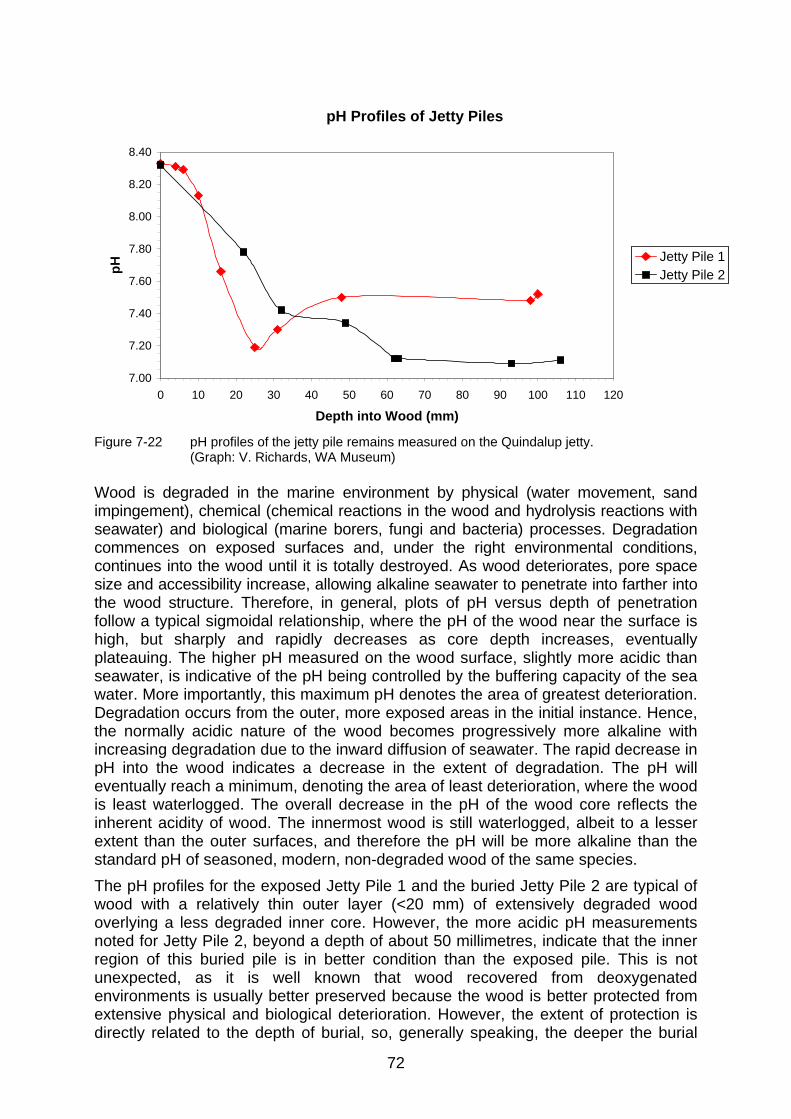
72
pH Profiles of Jetty Piles
7.00
7.20
7.40
7.60
7.80
8.00
8.20
8.40
0 10 20 30 40 50 60 70 80 90 100 110 120
Depth into Wood (mm)
pH Jetty Pile 1
Jetty Pile 2
Figure 7-22 pH profiles of the jetty pile remains measured on the Quindalup jetty.
(Graph: V. Richards, WA Museum) Wood is degraded in the marine environment by physical (water movement, sand impingement), chemical (chemical reactions in the wood and hydrolysis reactions with seawater) and biological (marine borers, fungi and bacteria) processes. Degradation commences on exposed surfaces and, under the right environmental conditions, continues into the wood until it is totally destroyed. As wood deteriorates, pore space size and accessibility increase, allowing alkaline seawater to penetrate into farther into the wood structure. Therefore, in general, plots of pH versus depth of penetration follow a typical sigmoidal relationship, where the pH of the wood near the surface is high, but sharply and rapidly decreases as core depth increases, eventually plateauing. The higher pH measured on the wood surface, slightly more acidic than seawater, is indicative of the pH being controlled by the buffering capacity of the sea water. More importantly, this maximum pH denotes the area of greatest deterioration. Degradation occurs from the outer, more exposed areas in the initial instance. Hence, the normally acidic nature of the wood becomes progressively more alkaline with increasing degradation due to the inward diffusion of seawater. The rapid decrease in pH into the wood indicates a decrease in the extent of degradation. The pH will eventually reach a minimum, denoting the area of least deterioration, where the wood is least waterlogged. The overall decrease in the pH of the wood core reflects the inherent acidity of wood. The innermost wood is still waterlogged, albeit to a lesser extent than the outer surfaces, and therefore the pH will be more alkaline than the standard pH of seasoned, modern, non-degraded wood of the same species. The pH profiles for the exposed Jetty Pile 1 and the buried Jetty Pile 2 are typical of wood with a relatively thin outer layer (<20 mm) of extensively degraded wood overlying a less degraded inner core. However, the more acidic pH measurements noted for Jetty Pile 2, beyond a depth of about 50 millimetres, indicate that the inner region of this buried pile is in better condition than the exposed pile. This is not unexpected, as it is well known that wood recovered from deoxygenated environments is usually better preserved because the wood is better protected from extensive physical and biological deterioration. However, the extent of protection is directly related to the depth of burial, so, generally speaking, the deeper the burial

73
depth, the less degraded the wood. The majority of surface degradation on the buried pile would have occurred before the remains became buried. However, slow biodeterioration of the wood may continue under anoxic conditions due to the presence of erosion bacteria, which only survive in anaerobic environments. Maximum moisture content is an easily measured quantity which may be related to specific gravity and, thus, to the extent of degradation of the wood. It is universally used as an indicator of wood deterioration and is the basis of a classification scheme. Waterlogged timbers may be classified as follows: Class I (>400%)—an extremely degraded, extensive surface with very little solid core; Class II (185–400%) —a degraded surface with a thin, partially degraded area and a considerably larger solid core; Class III (<185%)—a very thin degraded surface layer, overlying an extensive non-degraded core (Pearson, 1987). Unfortunately, no core sample was collected from Jetty Pile 2, but core sample 1 taken from Jetty Pile 1 was 10 millimetres thick and possessed a very soft, degraded surface (2 mm), after which the wood was in relatively good condition, although there was evidence of teredo worm damage throughout the entire length of the core. The maximum water content of the wood core sample is 89%, indicating that the wood of this pile is Class III and corroborating the results of the pH profiles. The pile wood is tentatively identified as a Eucalyptus species, most probably jarrah (pers. comm. Godfrey 4 May 2009). Eucalypt species were a preferred choice for jetty piles because of their durability in the marine environment, especially in the cooler waters of the Western Australian south-west coast. Sediment
The pH of the sediment at a depth of 70 millimetres was 8.25. This is slightly more acidic than the surrounding aerobic seawater (pH 8.34av), which is to be expected, due to the oxidation of organic detritus by aerobic and facultative bacteria that produce acidic metabolites and by-products. However, this pH difference is not particularly significant and there was very little organic detritus observed on the seabed, which could explain the relatively higher pH of the sediment due to less aerobic oxidation of organic material. It is more likely, however, that there was some ingress of the surrounding seawater into the measurement hole. This would effectively increase the pH of the interstitial water more than would normally be expected at these depths for sediments of this finer particle size. The redox potential of the sediment at 130 millimetres was –0.110V, indicating that the sediment is mildly reducing at this depth. These redox potential and pH measurements indicate that the zero-Eh interface lies somewhere between 7 to 13 centimetres under the seawater/sediment interface. This implies that the overlying sediment above this depth range will be more alkaline and oxidising in nature. One sediment core sample was collected approximately 4 metres north of Jetty Pile 1 at a water depth of 2.4 metres. The total length of the core sample (QJ 55) was 240mm (Fig. 7-23). The core sample revealed a thin layer (19 mm) of dark grey, fine-grained sand overlying 12 millimetres of very black fine sand. Below this depth there was a 70-millimetres layer of grey, fine-grained sand overlying 139 millimetres of lighter grey, fine sand, with coarser grained particles distributed evenly throughout this lower layer. The typical grey to black colouration of sediment is indicative of anaerobic conditions, but it is important to note that when the sediment was first recovered, the upper sediment layers (100 mm) were white to light grey in colour and

74
slowly turned darker over a period of a few weeks. This colour change was caused by bacterial degradation of the organic material present in these sediment layers. The bacteria utilise dissolved oxygen in the sediment for their metabolic processes and, therefore, the layer becomes deoxygenated over time, causing this black discolouration. Alternatively, there was very little colour change in the lower core section (>100 mm), with the exception of some oxidation of reduced iron species to a typical red/brown colour, indicating that there was very little organic matter present in these lower depth layers. Hence, in order to avoid possible misinterpretation of the sediment data, the core samples should be photographed as soon as possible after recovery.
Figure 7-23 Sediment core sample (QJ 55) from the Quindalup jetty site. (Photograph: V.
Richards, WA Museum)
75
Despite these colour changes in the sediment core sample, the visual observations imply that the depth to stable sediment is approximately 10 centimetres, which supports the electrochemical measurements that indicated that the zero-Eh interface also occurs around this depth. The results of the sediment survey indicate that the sand in the upper 10 centimetres of the sediment column is fine-grained, relatively oxygenated and thus more oxidising in nature, and contains appreciable quantities of organic material to support bacterial activity. However, below this depth, the sediment becomes more stable, less oxygenated and therefore more reducing in nature, and contains considerably less organic content. The conservation implication of these observations for the site is that artefacts in the upper sediment layers would be subjected to more deterioration than those materials buried at depths greater than about 10 centimetres. Discussion
The Quindalup jetty site is an open circulation, well oxygenated, oxidising marine environment, typical of the Geographe Bay area. The Quindalup jetty remains lie approximately 100 metres offshore and about 100 metres north-west from the seaward end of the contemporary jetty. The remains were aligned on a roughly north-south transit covering an area approximately 10 metres2 and consisted of a few iron wheels and jetty pile remains and an iron railway track. The surrounding shoreline had a gentle sloping bathymetry towards the north with the depth to the jetty remains about 2.5 metres. The survey area was relatively level, comprising of fine grained calcareous sand with little organic detritus and epiphytes evident on the seabed surface, with the exception of dead seagrass fronds. There were extensive seagrass beds surrounding the survey area, however there had been some scouring of the seagrass in close proximity to the exposed iron wheels probably caused by the contemporary mooring located on-site. The results of the sediment survey indicate that the sand in the upper 10 centimetres of the sediment column is fine grained, relatively oxygenated and thus, more oxidising in nature containing appreciable quantities of organic material to support bacterial activity. However after this depth the sediment becomes more stable, less oxygenated and therefore, more reducing in nature with considerably less organic content. The conservation implications of these observations is that artefacts in the upper sediment layers would be subjected to more deterioration than those materials buried at depths greater than about 10 centimetres on this site. The corrosion survey indicated that all ferrous artefacts on the Quindalup jetty site were actively corroding; however the buried iron artefacts were in better condition than those materials constantly exposed to the aerobic marine environment. The corrosion survey of the exposed iron bogey suggested that it was part of the original Quindalup jetty and had been exposed for a considerable period of time. There was also some evidence of recent exposure of the iron track, indicating that some sediment movement does occur on the site, however the overall amount of sediment movement was minimal. Exposed jetty pile remains were covered with algal mats with very few higher marine organisms evident on the surfaces but exhibited extensive marine borer damage. The pH profiles for the exposed Jetty Pile 1 and the buried Jetty Pile 2 were typical of wood with a relatively thin outer layer (<20 mm) of extensively degraded wood overlying a less degraded inner core. However, the more acidic pH measurements

76
noted for Jetty Pile 2 after a depth of about 50 millimetres indicated that the inner region of this buried pile was in better condition than the exposed pile. This is not unexpected, as it is well known that wood recovered from deoxygenated environments is usually better preserved because the wood is predominantly protected from extensive physical and biological deterioration.

77
APPENDIX A
Date: 26 February 2009 Location: Busselton town jetty Dive Platform: Seaspray Dive Supervisor: Ross Anderson Activity: Training—conservation surveys Diver 1 Diver 2 Total dive time (min) Maximum depth (m) V. Richards J. Carpenter 6 8.5 W.Hassapak C. Wijamunige 6 8.5 V. Richards J. Carpenter 55 8.5 W.Hassapak C. Wijamunige 55 8.5

78
APPENDIX B Date: 27 February 2009 Location: Quindalup town jetty Dive Platform: Shore Dive Supervisor: Ross Anderson Activity: Conservation survey Diver 1 Diver 2 Total dive time (min) Maximum depth (m) V. Richards J. Carpenter 84 2.8
79
REFERENCES
Australian Heritage Commission
1990, Australian Heritage Commission Amendment Act 1990. http://www.comlaw.gov.au/Details/C2004A04092
Cumming, D.A., Garratt, D., McCarthy, M. & Wolfe, A. 1995, Port Related Structures on the Coast of Western Australia. Report no. 98, Department of Maritime Archaeology, Western Australian Museum, Fremantle.
De Kerchove, R. 1961 (2nd edition), International Maritime Dictionary. Original publication, 1948. Van Nostrand, New Jersey.
Drew, P. 1994, The Coast Dwellers: Australian living on the edge. Penguin books, Ringwood, Victoria.
Fahrner, C.K. & Pattiaratchi, C.B. 1995, The Physical Oceanography of Geographe Bay, Western Australia in Geographe Bay Summary Report: Wastewater 2040 strategy for the South West region, ed. D.A. Lord, pp. 3–12. Water Authority of Western Australia, Perth.
Garratt, D. 1993a (December), Wonnerup Jetty. Report no. 73, Department of Maritime Archaeology, Western Australian Museum, Fremantle.
Garratt, D. 1993b (December), Quindalup Jetty. Report no. 74, Department of Maritime Archaeology, Western Australian Museum, Fremantle.
Gerritsen, R. 1995, An Historical Analysis of Wrecks in the Vicinity of the Deadwater, Wonnerup, Western Australia. Report no. 97, Department of Maritime Archaeology, Western Australian Museum, Fremantle.
Gibbs, M. 1994, An Archaeological Conservation and Management Study of 19th Century Shore-Based Whaling Stations in Western Australia. Report to the National Trust of Australia, Australian Heritage Commission, Perth.
Guidelines to the Burra Charter 1988, Guidelines to the Burra Charter: Cultural significance. Australia ICOMOS Inc. http://australia.icomos.org/publications/charters/
Henderson, G. 2007, Unfinished Voyages: Western Australian shipwrecks 1622–1850. University of Western Australia Press, Crawley.

80
Pearson, C. (ed.) 1987, Conservation of Marine Archaeological Objects. Butterworths, Sydney.
Peters, E. 1977, The Electrochemistry of Sulphide Minerals, in Trends in Electrochemistry, eds J. O'M. Bockris, D.A.J. Rand & B.J. Welch, p. 277. Plenum Press, New York.
Staniforth, M. 2008, Australia: Flinders University, South Australia, SHA Newsletter 41.3 (Fall): 69–70.
Walter, H. 1979, Vegetation of the Earth in Relation to Climate and the Eco-Physiological Conditions. Springer-Verlag, New York.
Worsley, J., and Worsley, P. (In Prep), Capes of Sunset: Western Australia¹s Maritime Heritage between Peel Inlet & Flinders Bay. Department of Maritime Archaeology, Western Australian Museum, Fremantle.