2.0 PROPOSED ACTIONS AND ALTERN 2.pdf · BLM CDD 2.0 Proposed Plan and Alternatives NEMO CMP/FEIS,...
116
BLM CDD 2.0 Proposed Plan and Alternatives NEMO CMP/FEIS, July 2002 2-1 2.0 Proposed Plan and Alternatives This chapter identifies a range of alternatives to address the purpose and need described in Chapter One. A summary list of the major issues is given in Table 2.1. Table 2.1 – Major Issues Issue Section How Issue Is Addressed In This Plan A. Public Land Health 2.1 Adopt standards for public land health and guidelines for grazing management Desert Tortoise 2.2 Establish Desert Tortoise Wildlife Management Areas and adopt management strategies within DWMA boundaries: Designate Areas of Critical Environmental Concern on all public lands within DWMAs Assign MUC L to all public lands within DWMAs Change desert tortoise habitat to all Category I inside and all Category III outside of DWMAs Change grazing management to recover the desert tortoise Change burro management to recover the desert tortoise Amargosa Vole 2.3 Designate an ACEC and adopt management strategies to facilitate recovery of the Amargosa vole and enhance other Amargosa watershed values T&E Plants 2.4 Establish the Carson Slough ACEC and adopt management strategies to recover Threatened & Endangered plants B. Threatened and Endangered and Special Status Species Protection: Bats 2.5 Modify the MUC of the Silurian Hills to conserve BLM-sensitive bats 2.6 Complete plan maintenance actions to conform the CDCA plan to the California Desert Protection Act 2.7 Establish MUC for 475,000 acres of released WSA C. Issues resulting from the California Desert Protection Act 2.8 Evaluate the remnant Greenwater Canyon ACEC (820 acres) D. Organized Competitive Vehicle Events 2.9 Address organized competitive vehicle events outside of open areas to protect sensitive resources and address fragmented race course: Delete or modify the Barstow to Las Vegas race course Modify organized competitive vehicle speed events criteria E. Motor Vehicle Access: Routes of Travel Designation 2.10 Address routes of travel designation for the NEMO planning area: Designate routes of travel in desert tortoise DWMAs Identify the process and priorities for route designation in the rest of the planning area Evaluate MUC guidelines for consistency in determining routes to be included in the routes of travel network Change the Tecopa Landfill MUC L to U making it available for disposal. E. Bureau policy on elimination of landfills on public lands 2.11 Change the Shoshone Landfill MUC L to U making it available for disposal. F. Wild and Scenic Rivers 2.12 Identify portions of the Amargosa River, Cottonwood Creek and Surprise Canyon Creek as eligible for potential inclusion in the National Wild and Scenic Rivers System and determine classification of eligible segments Outline the process / additional steps for development of W&SR recommendations to Congress.
Transcript of 2.0 PROPOSED ACTIONS AND ALTERN 2.pdf · BLM CDD 2.0 Proposed Plan and Alternatives NEMO CMP/FEIS,...

BLM CDD 2.0 Proposed Plan and Alternatives NEMO CMP/FEIS, July 2002
2-1
2.0 Proposed Plan and Alternatives This chapter identifies a range of alternatives to address the purpose and need described in Chapter One. A summary list of the major issues is given in Table 2.1.
Table 2.1 – Major Issues
Issue Section How Issue Is Addressed In This Plan A. Public Land Health 2.1 Adopt standards for public land health and guidelines for grazing
management DesertTortoise
2.2 Establish Desert Tortoise Wildlife Management Areas and adopt management strategies within DWMA boundaries: �� Designate Areas of Critical Environmental Concern on all public lands
within DWMAs �� Assign MUC L to all public lands within DWMAs �� Change desert tortoise habitat to all Category I inside and all Category III
outside of DWMAs �� Change grazing management to recover the desert tortoise �� Change burro management to recover the desert tortoise
Amargosa Vole
2.3 Designate an ACEC and adopt management strategies to facilitate recovery of the Amargosa vole and enhance other Amargosa watershed values
T&E Plants 2.4 Establish the Carson Slough ACEC and adopt management strategies to recover Threatened & Endangered plants
B. Threatened and Endangered and Special Status Species Protection:
Bats 2.5 Modify the MUC of the Silurian Hills to conserve BLM-sensitive bats 2.6 Complete plan maintenance actions to conform the CDCA plan to the
California Desert Protection Act 2.7 Establish MUC for 475,000 acres of released WSA
C. Issues resulting from the California Desert Protection Act
2.8 Evaluate the remnant Greenwater Canyon ACEC (820 acres) D. Organized Competitive Vehicle Events
2.9 Address organized competitive vehicle events outside of open areas to protect sensitive resources and address fragmented race course: �� Delete or modify the Barstow to Las Vegas race course �� Modify organized competitive vehicle speed events criteria
E. Motor Vehicle Access: Routes of Travel Designation
2.10 Address routes of travel designation for the NEMO planning area: �� Designate routes of travel in desert tortoise DWMAs �� Identify the process and priorities for route designation in the rest of the
planning area �� Evaluate MUC guidelines for consistency in determining routes to be
included in the routes of travel network Change the Tecopa Landfill MUC L to U making it available for disposal. E. Bureau policy on
elimination of landfills on public lands
2.11
Change the Shoshone Landfill MUC L to U making it available for disposal.
F. Wild and Scenic Rivers 2.12 Identify portions of the Amargosa River, Cottonwood Creek and Surprise Canyon Creek as eligible for potential inclusion in the National Wild and Scenic Rivers System and determine classification of eligible segments �� Outline the process / additional steps for development of W&SR
recommendations to Congress.

BLM CDD 2.0 Proposed Plan Amendments and Alternatives NEMO CMP/FEIS, July 2002 2.1 Standards and Guidelines
2-2
2.1 Standards and Guidelines BLM’s grazing regulations at Part 43 CFR 4180 require that State Directors, in consultation with Resource Advisory Councils, develop standards of rangeland health and guidelines for grazing management. The grazing regulations require that standards be in conformance with the “Fundamentals of Rangeland Health” (BLM policy developed in 1993) and that the standards and guidelines address each of the “guiding principles” as defined in the regulations (see Appendix B). Standards and guidelines are to be incorporated into BLM’s land use plans to improve ecological conditions. Improving ecological conditions is based upon attainment and maintenance of basic fundamentals for healthy systems. Standards and guidelines are defined as follows:
�� A “standard” is an expression of the levels of physical and biological condition or degree of function required for healthy, sustainable rangelands.
�� “Guidelines” for grazing management are the types of grazing management methods and practices determined to be appropriate to ensure that the standards can be met or that significant progress can be made toward meeting the standard.
Plan Alternatives and ScopeBy this planning effort, public land health standards will be developed and applied to resources and uses on the public (BLM) lands within the Northern and Eastern Mojave Desert planning area and grazing management guidelines will be developed and applied to grazing leases. The policy includes a set of “National Fallback” standards and guidelines that apply only to livestock grazing in the Current Management/No Action Alternative. For all other alternatives, common sets of “regional” standards and guidelines have been developed. Regional standards apply to all BLM lands and programs, while regional guidelines still only apply to livestock grazing. Bureau staff, in consultation with the California Desert District Advisory Council, have developed the regional standards and guidelines which satisfies the requirements of BLM’s strategic plan, complies with the fundamentals of rangeland health, and addresses each of the guiding principles as required by the grazing regulations. Their development of guidelines for grazing management also addresses each of the guiding principles. At this time there are no plans to develop guidelines for other activities.
The purpose and nature of this policy is similar to the “Vital Signs” program established for the National Park Service. While the definition and adoption of standards and guidelines apply specifically and only to BLM lands, the spirit of the policy is reflected throughout the planning area in developing the strategic approach to managing species and habitats.
Required Actions on Grazing Leases Standards and grazing management guidelines apply to grazing related portions of activity plans, terms and conditions of permits, leases, and other authorizations, and range improvements such as vegetation manipulation, fence construction and development of water. For lands leased for grazing, the regulations require the authorized officer to “take appropriate action” prior to the beginning of the next grazing season when standards are not achieved or guidelines are not complied with, and livestock grazing has been determined to be a significant factor in the failure to achieve the standard or comply with the guideline.
Application of Standards in Land Use Planning Standards of Public Land Health will be applied to all resources and uses of the public lands. Both sets of standards would be applied in the following manner:
�� Public Land Health Standards: A single set of public land health standards will be applied desert-wide and to all resources and uses. Standards have their foundation in the physical and biological laws of nature. These laws are consistent regardless of the resource or use.

BLM CDD 2.0 Proposed Plan Amendments and Alternatives NEMO CMP/FEIS, July 2002 2.1 Standards and Guidelines
2-3
�� Assessment of Public Land Health: The health of public lands and resources will be assessed using the standards as the measurement of desired function.
�� Assessment Scale: The health of the public lands will be assessed on a landscape /watershed scale. While it may be useful and necessary to examine certain environmental components at various scales, it is intended that there be just one measure or conclusion of overall public land health, and that this conclusion be made at a landscape or watershed scale.
�� Health Determination: Since standards are a statement of the goals for physical or biological function, these determinations will be based strictly on the results of resource assessments and independent of the uses on the public lands.
�� Resource Objectives: Resource management objectives are decisions made in consideration of resource values and capabilities and use needs through land use and activity plans. Public land health determinations will be used to determine if resource management objectives are being met. In some cases, particularly where intensive land uses are allowed, resource management objectives could be met, while the public land health determination may indicate non-conformance with the standards.
�� Causal Factors: When public land health determinations indicate that resource management objectives are not being met, a determination of cause(s) will be made.
�� Action/Adaptive Management: Where resource conditions and functions do not conform to resource management objectives, appropriate action, including changes to land use or activity plans, will be initiated using existing regulatory authorities for each authorized activity. In the case of livestock grazing, the regulations require that the authorized Officer “take appropriate action” prior to the beginning of the next grazing season when standards are not achieved or guidelines not complied with and livestock grazing has been determined to be a significant factor in the failure to achieve the standard or comply with the guideline.
�� Monitoring/ Adaptive Management: An assessment of public land health will define the status and location of environmental conditions. This knowledge will help determine if management changes are warranted and if needed, track progress towards health improvement.
Application of Standards in NEPA Analyses Analyses of resources and issues guided by standards will help NEPA1 review of projects. Consideration of standards should improve identification and analyses of:
�� Relevant resource conditions and ecosystem functions
�� Actions, in terms of effects on resources and ecosystem functions
�� The relationship of biological and physical resources and functions
�� The most important resources and functions
�� Project design and mitigation
�� Cumulative effects
�� Short-term and long-term effects
�� Project monitoring
1 National Environmental Policy Act of 1972

BLM CDD 2.0 Proposed Plan Amendments and Alternatives NEMO CMP/FEIS, July 2002 2.1 Standards and Guidelines
2-4
Alternative 1 – No Action Standards of Rangeland Health in the NEMO Planning Area Continue to utilize existing National Fallback Standards for grazing allotments. Fallback standards were developed to implement 43 CFR, Subpart 4180 grazing regulations. The fallback standards for rangeland health are:
1. Upland soils exhibit infiltration and permeability rates that are appropriate to soil type, climate, and landform.
2. Riparian-wetland areas function properly.
3. Stream-channel morphology (including but not limited to gradient, width/depth ratio, channel roughness, and sinuosity) and functions are appropriate for the climate and landform.
4. Healthy, productive and diverse populations of native species exist and are maintained.
Rangeland Guidelines for Grazing Uses in the NEMO Planning Area Utilize existing National Fallback Guidelines for grazing management. Fallback guidelines were developed in conjunction with standards to implement 43 CFR Subpart 4180. Guidelines identify 15 grazing management practices to achieve the fallback standards.
1. Management practices maintain or promote adequate amounts of ground cover to support infiltration, maintain soil moisture, and stabilize soils.
2. Management practices maintain or promote soil conditions that support permeability rates that are appropriate to climate and soils.
3. Management practices maintain or promote sufficient residual vegetation to maintain, improve, or restore riparian-wetland functions of energy dissipation, sediment capture, groundwater recharge and stream bank stability.
4. Management practices maintain or promote stream channel morphology (e.g., gradient, width/depth ratio, channel roughness and sinuosity) and functions that are appropriate to climate and landform.
5. Management practices maintain or promote the appropriate kinds and amounts of soil organisms, plants and animals to support the hydrologic cycle, nutrient cycle, and energy flow.
6. Management practices maintain or promote the physical and biological conditions necessary to sustain native populations and communities.
7. Desired species are being allowed to complete seed dissemination in one out of every three years (Management actions will promote the opportunity for seedling establishment when climatic conditions and space allow).
8. Conservation of federally threatened or endangered, proposed, Category I and II candidates, and other special status species is promoted by restoration and maintenance of their habitats.
9. Native species are emphasized in the support of ecological functions.
10. Non-native plant species are used only in those situations in which native species are not readily available in sufficient quantities or are incapable of maintaining or achieving properly functioning conditions and biological health.

BLM CDD 2.0 Proposed Plan Amendments and Alternatives NEMO CMP/FEIS, July 2002 2.1 Standards and Guidelines
2-5
11. Periods of rest from disturbance or livestock use during times of critical plant growth or regrowth are provided when needed to achieve healthy, properly functioning conditions (The timing and duration of use periods shall be determined by the authorized officer).
12. Continuous, season-long livestock use is allowed to occur only when it has been demonstrated to be consistent with achieving healthy, properly functioning ecosystems.
13. Facilities are located away from riparian-wetland areas wherever they conflict with achieving or maintaining riparian-wetland function.
14. Development of springs and seeps or other projects affecting water and associated resources shall be designed to protect the ecological functions and processes of those sites.
15. Grazing on designated ephemeral (annual and perennial) rangeland is allowed to occur only if reliable estimates of production have been made. The BLM has established an identified level of annual growth or residue that is appropriate to remain on site at the end of the grazing season, and adverse effects on perennial species are avoided.
2.1.2 Alternative 2 – Proposed Plan Standards of Public Land Health in the NEMO Planning Area Adopt a set of regional standards of public land health in the NEMO planning area. These regional standards would replace the fallback standards currently in effect. Regional standards of public land health address all resources and uses on all public lands and cover four environmental components to be applied in the context of public land management.
Soils: Soils exhibit infiltration and permeability rates that are appropriate to soil type, climate, geology, landform, and past uses. Adequate infiltration and permeability of soils allow accumulation of soil moisture necessary for optimal plant growth and vigor, and provide a stable watershed. As indicated by:
�� Canopy and ground cover are appropriate for the site
�� Diversity of plant species with a variety of root depths
�� Litter and soil organic matter are present at suitable sites
�� Microbiotic soil crusts are maintained and in place
�� Evidence of wind or water erosion does not exceed natural rates for the site
�� Hydrology and nutrient factors maintained by soil permeability and water infiltration appropriate for precipitation
Native Species: Healthy, productive and diverse habitats for native species, including special status species (Federal T&E, federally proposed, federal candidates, BLM- sensitive, or California State T&E, and unusual plant assemblages) are maintained in places of natural occurrence. As indicated by:
�� Photosynthetic and ecological processes continue at levels suitable for the site, season, and precipitation regimes
�� Plant vigor, nutrient cycles, and energy flows are maintaining desirable plants and ensuring reproduction and recruitment

BLM CDD 2.0 Proposed Plan Amendments and Alternatives NEMO CMP/FEIS, July 2002 2.1 Standards and Guidelines
2-6
�� Plant communities are producing adequate limits
�� Age class distribution of plants and animals are sufficient to overcome mortality fluctuations
�� Distribution and cover of plant species and their habitats allow for reproduction and recovery from localized catastrophic events
�� Alien and noxious plants and wildlife do not exceed acceptable levels
�� Appropriate natural disturbances are evident
�� Populations and their habitats are sufficiently distributed to prevent the need for listing special status species
Riparian/Wetland and Stream Function: Wetland systems associated with subsurface, running, and standing water function properly and have the ability to recover from major disturbance (Refer to Appendix J). Hydrologic conditions are maintained, as indicated by:
�� Vegetative cover adequately protects banks and dissipates energy during peak water flows
�� Dominant vegetation is an appropriate mixture of vigorous riparian species
�� Recruitment of preferred species is adequate to sustain the plant community
�� Stable soils store and release water slowly
�� Plant species present indicate soil moisture characteristics are being maintained
�� There is minimal cover of shallow-rooted invader species, and they are not displacing deep-rooted native species
�� Shading of stream courses and water sources for riparian dependent species is maintained
�� Stream is in balance with water and sediment being supplied by the watershed
�� Stream channel size and meander is appropriate for soils, geology, and landscape
�� Adequate organic matter (litter and standing dead plant material) is present to protect the site and to replenish soil nutrients through decomposition
BLM CDD 2.0 Proposed Plan Amendments and Alternatives NEMO CMP/FEIS, July 2002 2.1 Standards and Guidelines
2-7
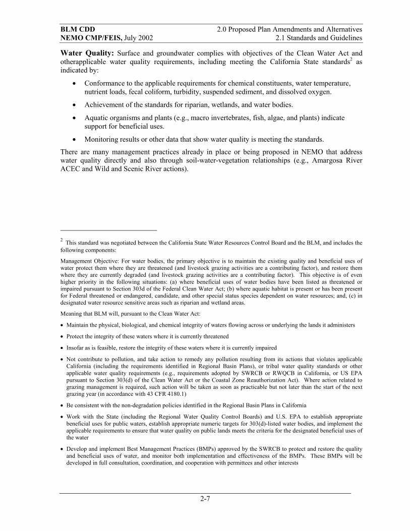
Water Quality: Surface and groundwater complies with objectives of the Clean Water Act and otherapplicable water quality requirements, including meeting the California State standards2 as indicated by:
�� Conformance to the applicable requirements for chemical constituents, water temperature, nutrient loads, fecal coliform, turbidity, suspended sediment, and dissolved oxygen.
�� Achievement of the standards for riparian, wetlands, and water bodies.
�� Aquatic organisms and plants (e.g., macro invertebrates, fish, algae, and plants) indicate support for beneficial uses.
�� Monitoring results or other data that show water quality is meeting the standards.
There are many management practices already in place or being proposed in NEMO that address water quality directly and also through soil-water-vegetation relationships (e.g., Amargosa River ACEC and Wild and Scenic River actions).
2 This standard was negotiated between the California State Water Resources Control Board and the BLM, and includes the following components:
Management Objective: For water bodies, the primary objective is to maintain the existing quality and beneficial uses of water protect them where they are threatened (and livestock grazing activities are a contributing factor), and restore them where they are currently degraded (and livestock grazing activities are a contributing factor). This objective is of even higher priority in the following situations: (a) where beneficial uses of water bodies have been listed as threatened or impaired pursuant to Section 303d of the Federal Clean Water Act; (b) where aquatic habitat is present or has been present for Federal threatened or endangered, candidate, and other special status species dependent on water resources; and, (c) in designated water resource sensitive areas such as riparian and wetland areas.
Meaning that BLM will, pursuant to the Clean Water Act:
�� Maintain the physical, biological, and chemical integrity of waters flowing across or underlying the lands it administers
�� Protect the integrity of these waters where it is currently threatened
�� Insofar as is feasible, restore the integrity of these waters where it is currently impaired
�� Not contribute to pollution, and take action to remedy any pollution resulting from its actions that violates applicable California (including the requirements identified in Regional Basin Plans), or tribal water quality standards or other applicable water quality requirements (e.g., requirements adopted by SWRCB or RWQCB in California, or US EPA pursuant to Section 303(d) of the Clean Water Act or the Coastal Zone Reauthorization Act). Where action related to grazing management is required, such action will be taken as soon as practicable but not later than the start of the next grazing year (in accordance with 43 CFR 4180.1)
�� Be consistent with the non-degradation policies identified in the Regional Basin Plans in California
�� Work with the State (including the Regional Water Quality Control Boards) and U.S. EPA to establish appropriate beneficial uses for public waters, establish appropriate numeric targets for 303(d)-listed water bodies, and implement the applicable requirements to ensure that water quality on public lands meets the criteria for the designated beneficial uses of the water
�� Develop and implement Best Management Practices (BMPs) approved by the SWRCB to protect and restore the quality and beneficial uses of water, and monitor both implementation and effectiveness of the BMPs. These BMPs will be developed in full consultation, coordination, and cooperation with permittees and other interests

BLM CDD 2.0 Proposed Plan Amendments and Alternatives NEMO CMP/FEIS, July 2002 2.1 Standards and Guidelines
2-8
Rangeland Guidelines For Grazing Uses in the NEMO Planning AreaThe Proposed Plan would adopt a set of regional guidelines in the NEMO planning area for grazing management. These regional guidelines would replace the current fallback guidelines, identify grazing management practices to achieve the regional standards and address the principles of grazing management practices as identified in 43 CFR 4180.2.
1. Facilities shall be located away from riparian-wetland areas wherever they conflict with achieving or maintaining riparian-wetland functions.
2. The development of springs and seeps or other projects affecting water and associated resources shall be designed to protect the ecological functions and processes of those sites.
3. Grazing activities at an existing range improvement that conflict with achieving proper functioning conditions (PFC) and resource objectives for wetland systems (lentic, lotic, springs, addits, and seeps) shall be modified so PFC and resource objectives can be met. Incompatible projects shall be modified to bring them into compliance. The BLM will consult, cooperate, and coordinate with affected interests and livestock producer(s) prior to authorizing modification of existing projects and initiation of new projects. New range improvement facilities shall be located away from wetland systems if they conflict with achieving or maintaining PFC and resource objectives.
4. Supplements shall be located a sufficient distance away from wetland systems so they do not conflict with maintaining riparian wetland functions.
5. Management practices shall maintain or promote perennial stream channel morphology and functions (e.g., gradient, width/depth ratio, channel roughness, and sinuosity) appropriate to climate and landform.
6. Grazing management practices shall meet state and federal water quality standards. Impoundments (stock ponds) and developed springs having a sustained discharge yield of less than 200 gallons per day to surface or groundwater are excepted from meeting state drinking water standards per SWRCB Resolution Number 88-63.
7. In the California Desert Conservation Area, all wildfires in grazing allotments shall be suppressed. However, to restore degraded habitats infested with invasive weeds (e.g., tamarisk) prescribed burning may be utilized as a tool for restoration. Prescribed burns may be used as a management tool where fire is a natural part of the regime.
8. In years when weather results in extraordinary conditions, seed germination, seedling establishment and native plant species growth shall be allowed by modifying grazing use.
9. Grazing on designated ephemeral rangeland shall be allowed only if reliable estimates of production have been made, an identified level of annual growth or residue to remain on site at the end of the grazing season has been established, and adverse effects on perennial species are avoided.
10. During prolonged drought, range stocking shall be reduced to achieve resource objectives and/or prescribed perennial forage utilization. On yearlong allotments, livestock utilization of key perennial species shall be checked prior to spring growing season (about March 1, when the Palmer Severity Drought Index/Standardized Precipitation Index indicates dry conditions are expected to continue.

BLM CDD 2.0 Proposed Plan Amendments and Alternatives NEMO CMP/FEIS, July 2002 2.1 Standards and Guidelines
2-9
11. Through the assessment process or monitoring efforts, the extent of invasive and/or exotic plants and animals shall be recorded and evaluated for future control measures. Methods and prescriptions shall be implemented, and an evaluation will be completed to ascertain future control measures for undesirable species.
12. Restore, maintain or enhance habitats to assist in the recovery of federal listed threatened and endangered species. Restore, maintain or enhance habitats of special status species including federally proposed and candidate, BLM sensitive, or California State T&E to promote their conservation.
13. Grazing activities shall support biological diversity across the landscape, and native species and microbiotic crusts are to be maintained.
14. Experimental and research efforts shall be encouraged to provide answers to grazing management and related resource concerns through cooperative and collaborative efforts with outside agencies, groups, and entities.
15. Livestock utilization limits of key perennial species would be as shown in Table 2.2 for the various range types
Table 2.2 – Proposed Plan Grazing Guidelines for Range Types
Percent Use of Key Perennial Species Range Type Poor-Fair Range Condition or
Growing Season3Good-Excellent Range Condition or
Dormant Season3
Mojave Sonoran Desert scrub 25 40 Salt Desert shrub land 25 35 Semi-desert grass and shrub land 30 40 Sagebrush grassland 30 40 Mountain shrub land 30 40
Monitoring of grazing allotment conditions will be routinely assessed to determine if Public Land Health Standards are being met. In those areas not meeting one or more standards, monitoring processes will be established, if they do not presently exist, to monitor indicators of health until the standard or resource objective has been attained. Livestock trail networks, grazed plants, livestock facilities, and animal waste are expected impacts in all grazing allotments, and will be considered during analysis of the assessment and monitoring process. Activity plans for other uses or resources that overlap an allotment could have prescribed resource objectives that may constrain grazing activities, e.g., ACEC. In areas where a standard(s) has not been met, changes to grazing management would be required to meet standards, and will be reviewed annually. During the final phase of the assessment process, the Range Determination includes the schedule for the next assessment of resource conditions. To attain standards and resource objectives, the best science will be used to determine appropriate grazing management actions. Cooperative funding and assistance from other agencies, individuals, and groups will be sought to collect monitoring data for indicators of each standard.
3 Rangeland in good condition or grazed during the dormant season can withstand the higher utilization level. Rangelands in poor condition or grazed during the active growth season would receive lower use levels.

BLM CDD 2.0 Proposed Plan Amendments and Alternatives NEMO CMP/FEIS, July 2002 2.1 Standards and Guidelines
2-10
Table 2.3 summarizes the No Action Alternative and the Proposed Plan for standards and guidelines for public land health. The No Action Alternative would use National Fallback standards while the Proposed Plan would adopt regional standards for public land health.

BLM
CD
D2.
0 Pr
opos
ed P
lan
and
Alte
rnat
ives
N
EMO
CM
P/FE
IS, J
uly
2002
2.
1 St
anda
rds a
nd G
uide
lines
2-11
Tab
le 2
.3 –
Sta
ndar
ds a
nd G
uide
lines
: Sum
mar
y C
ompa
riso
n of
Alte
rnat
ives
Stan
dard
s and
Gui
delin
es
Alte
rnat
ive
1 –
No
Act
ion
Alte
rnat
ive
2 –
Prop
osed
Pla
n C
ontin
ue to
util
ize
exis
ting
natio
nal
fallb
ack
stan
dard
s of r
ange
land
he
alth
for g
razi
ng a
llotm
ents
st
anda
rds i
nclu
ding
the
follo
win
g fo
ur e
nviro
nmen
tal c
ompo
nent
s:
��
Upl
and
soils
exh
ibit
infil
tratio
n an
d pe
rmea
bilit
y ra
tes t
hat a
re a
ppro
pria
te to
so
il ty
pe, c
limat
e, a
nd
land
form
.
��
Rip
aria
n-w
etla
nd a
reas
are
in
prop
er fu
nctio
ning
con
ditio
n.
��
Hea
lthy,
pro
duct
ive
and
dive
rse
popu
latio
ns o
f nat
ive
spec
ies e
xist
and
are
m
aint
aine
d.
��
Stre
am-c
hann
el m
orph
olog
y (in
clud
ing
but n
ot li
mite
d to
gr
adie
nt, w
idth
/dep
th ra
tio,
chan
nel r
ough
ness
, and
si
nuos
ity) a
nd fu
nctio
ns a
re
appr
opria
te fo
r the
clim
ate
and
land
form
.
Ado
pt a
set o
f reg
iona
l sta
ndar
ds o
f pub
lic la
nd h
ealth
for a
ll pu
blic
land
s in
the
NEM
O p
lann
ing
area
.
Soils
: Soi
ls e
xhib
it in
filtra
tion
and
perm
eabi
lity
rate
s tha
t are
app
ropr
iate
to so
il ty
pe, c
limat
e, g
eolo
gy, l
andf
orm
, and
pas
t use
s. A
dequ
ate
infil
tratio
n an
d pe
rmea
bilit
y of
soils
allo
w a
ccum
ulat
ion
of so
il m
oist
ure
nece
ssar
y fo
r opt
imal
pla
nt g
row
th a
nd v
igor
, and
pro
vide
a st
able
w
ater
shed
, as i
ndic
ated
by:
��
Can
opy
and
grou
nd c
over
are
app
ropr
iate
for t
he si
te
��
Ther
e is
div
ersi
ty o
f pla
nt sp
ecie
s with
a v
arie
ty o
f roo
t dep
ths
��
Litte
r and
soil
orga
nic
mat
ter a
re p
rese
nt a
t sui
tabl
e si
tes
��
Mic
ro b
iotic
soil
crus
ts ar
e m
aint
aine
d an
d in
pla
ce
��
Evid
ence
of w
ind
or w
ater
ero
sion
doe
s not
exc
eed
natu
ral r
ates
for t
he si
te
��
Soil
perm
eabi
lity,
nut
rient
cyc
ling
and
wat
er in
filtra
tion
are
appr
opria
te fo
r the
soil
type
R
ipar
ian/
Wet
land
and
Str
eam
Fun
ctio
n: W
etla
nd sy
stem
s ass
ocia
ted
with
subs
urfa
ce, r
unni
ng, a
nd st
andi
ng w
ater
func
tion
prop
erly
an
d ha
ve th
e ab
ility
to re
cove
r fro
m m
ajor
dis
turb
ance
s. H
ydro
logi
c co
nditi
ons a
re m
aint
aine
d, a
s ind
icat
ed b
y:
��
Veg
etat
ive
cove
r ade
quat
ely
prot
ects
ban
ks a
nd d
issi
pate
s ene
rgy
durin
g pe
ak w
ater
flow
s ��
Dom
inan
t veg
etat
ion
is a
n ap
prop
riate
mix
ture
of v
igor
ous r
ipar
ian
spec
ies
��
Rec
ruitm
ent o
f pre
ferr
ed sp
ecie
s is a
dequ
ate
to su
stai
n th
e pl
ant c
omm
unity
��
Stab
le so
ils st
ore
and
rele
ase
wat
er sl
owly
��
Plan
t spe
cies
pre
sent
indi
cate
soil
moi
stur
e ch
arac
teris
tics a
re b
eing
mai
ntai
ned
��
Ther
e is
min
imal
cov
er o
f sha
llow
-roo
ted
inva
der s
peci
es, a
nd th
ey a
re n
ot d
ispla
cing
dee
p-ro
oted
nat
ive
spec
ies.
��
Shad
ing
of st
ream
cou
rses
and
wat
er so
urce
s sup
port
ripar
ian
verte
brat
es a
nd in
verte
brat
es;
��
Stre
am is
in b
alan
ce w
ith w
ater
and
sedi
men
t bei
ng su
pplie
d by
the
wat
ersh
ed;
��
Stre
am c
hann
el si
ze a
nd m
eand
er is
app
ropr
iate
for s
oils
geo
logy
, and
land
scap
e; a
nd
��
Ade
quat
e or
gani
c m
atte
r (lit
ter a
nd st
andi
ng d
ead
plan
t mat
eria
l) is
pre
sent
to p
rote
ct th
e si
te a
nd to
repl
enis
h so
il nu
trien
ts th
roug
h de
com
h de
com
posi
tion.

BLM
CD
D2.
0 Pr
opos
ed P
lan
and
Alte
rnat
ives
N
EMO
CM
P/FE
IS, J
uly
2002
2.
1 St
anda
rds a
nd G
uide
lines
2-12
Stan
dard
s and
Gui
delin
es
Alte
rnat
ive
1 –
No
Act
ion
Alte
rnat
ive
2 –
Prop
osed
Pla
n
Nat
ive
Spec
ies:
Hea
lthy,
pro
duct
ive
and
dive
rse
habi
tats
for n
ativ
e sp
ecie
s inc
ludi
ng sp
ecia
l sta
tus s
peci
es (F
eder
al T
&E,
fede
rally
pr
opos
ed, f
eder
al c
andi
date
s, B
LM se
nsiti
ve, o
r Cal
iforn
ia S
tate
T&
E, a
nd u
nusu
al p
lant
ass
embl
ages
) are
mai
ntai
ned
in p
lace
s of n
atur
al
occu
rren
ce, a
s ind
icat
ed b
y:
��
Phot
osyn
thet
ic a
nd e
colo
gica
l pro
cess
es c
ontin
ue a
t lev
els s
uita
ble
for t
he si
te, s
easo
n, a
nd p
reci
pita
tion
regi
mes
��
Plan
t vig
or n
utrie
nt c
ycle
s and
ene
rgy
flow
s are
mai
ntai
ning
des
irabl
e pl
ants
and
ens
urin
g re
prod
uctio
n an
d re
crui
tmen
t ��
Plan
t com
mun
ities
are
pro
duci
ng li
tter w
ithin
acc
epta
ble
limits
��
Age
cla
ss d
istri
butio
n of
pla
nts a
nd a
nim
als a
re su
ffici
ent t
o ov
erco
me
mor
talit
y flu
ctua
tions
��
Dis
tribu
tion
and
cove
r of p
lant
spec
ies a
nd th
eir h
abita
ts a
llow
for r
epro
duct
ion
and
reco
very
from
loca
lized
cat
astro
phic
eve
nts
��
Alie
n an
d no
xiou
s pla
nts a
nd w
ildlif
e do
not
exc
eed
acce
ptab
le le
vels
��
App
ropr
iate
nat
ural
dis
turb
ance
s are
evi
dent
��
Popu
latio
ns a
nd th
eir h
abita
ts a
re su
ffici
ently
dis
tribu
ted
to p
reve
nt th
e ne
ed fo
r lis
ting
spec
ial s
tatu
s spe
cies
W
ater
Qua
lity:
Wat
er q
ualit
y w
ill m
eet s
tate
and
sede
ral s
tand
ards
incl
udin
g ex
empt
ions
allo
wab
le b
y la
w. A
s ind
icat
ed b
y:
��
Dis
solv
ed o
xyge
n le
vels
, aqu
atic
org
anis
ms a
nd p
lant
s (e.
g., m
acro
inve
rtebr
ates
, fis
h an
d al
gae)
indi
cate
supp
ort o
f ben
efic
ial u
ses;
��
Che
mic
al c
onst
ituen
ts, w
ater
tem
pera
ture
, nut
rient
load
s, fe
cal c
olifo
rm a
nd tu
rbid
ity a
re a
ppro
pria
te fo
r the
site
or s
ourc
e; a
nd
��
Bes
t man
agem
ent p
ract
ices
will
be
impl
emen
ted.
Gra
zing
Man
agem
ent G
uide
lines
A
ltern
ativ
e 1
– N
o A
ctio
n A
ltern
ativ
e 2
– Pr
opos
ed P
lan
U
se e
xist
ing
natio
nal f
allb
ack
guid
elin
es fo
r gra
zing
man
agem
ent
that
iden
tify
15 g
razi
ng p
ract
ices
to
achi
eve
the
fallb
ack
stan
dard
s, lis
ted
iin S
ectio
n 2.
1.1
of th
is
Cha
pter
.
Ado
pt a
set o
f reg
iona
l gui
delin
es in
the
NEM
O p
lann
ing
area
for g
razi
ng m
anag
emen
t. T
hese
regi
onal
gui
delin
es w
ould
repl
ace
the
curr
ent f
allb
ack
guid
elin
es a
nd in
clud
e ad
ditio
nal t
ools
(e.g
. wild
fire)
and
a m
ore
com
preh
ensi
ve se
t of g
uide
lines
. Th
ey w
ould
iden
tify
graz
ing
man
agem
ent p
ract
ices
to a
chie
ve th
e re
gion
al st
anda
rds a
nd w
ould
add
ress
the
prin
cipl
es o
f gra
zing
man
agem
ent p
ract
ices
as
iden
tifie
d in
43
CFR
418
0.2.
. Th
e gu
idel
ines
are
list
ed in
Sec
tion
2.1.
2 of
this
Cha
pter
.
BLM CDD 2.0 Proposed Plan and Alternatives NEMO CMP/FEIS, July 2002 2.2 Desert Tortoise Conservation and Recovery
2-13
2.2 Desert Tortoise Conservation and Recovery The Alternatives identified in this document are intended to promote the recovery of the desert tortoise. The goal of any adopted strategy, at a minimum, would be to achieve the recovery criteria defined within the Recovery Plan for Desert Tortoise (Mojave Population 1994, USFWS). Meeting these criteria would achieve the necessary progress to de-list the desert tortoise. These recovery criteria are listed in the Proposed Desert Tortoise Conservation Strategy (Appendix A, page A-1).The Recovery Plan (pp. 45-55) recommended several actions to meet recovery criteria objectives. Chief among these were:
�� Establish areas where viable desert tortoise populations are maintained
�� Develop and implement management prescriptions for these areas to address threats sufficient to meet recovery criteria
�� Provide sufficient habitat in these areas to ensure that management strategies are effective (See Appendix A discussion)
�� Monitor tortoise populations to assess effectiveness of management prescriptions in meeting recovery objectives in these areas (Refer to Appendix D)
�� Establish an environmental education program to facilitate understanding of desert tortoise threats and recovery needs, effect compliance with management strategies in these areas
�� Continue research necessary to assess relative importance of threats to the desert tortoise in these areas and to evaluate and improve mechanisms to address these threats
These recommended actions apply to desert tortoise populations and habitat in all of the Desert Tortoise Recovery Units and form the basis for the alternatives in the NEMO planning effort. If alternative strategies were identified that also met the recovery objectives, they were also considered. Therefore, the six recovery plan actions and the No Action Alternative form the parameters for the range of alternatives. Not all actions require CDCA plan-level decisions. For additional activity-level planning see Appendix A.
The alternatives for desert tortoise recovery respond to eighteen issues that involve potential threats to the desert tortoise and its habitat identified from the Desert Tortoise Recovery Plan (1994), other literature reviews, past biological assessments and USFWS Biological Opinions. Some of these potential threats were identified based on range-wide analyses covering all six Desert Tortoise Recovery Units. Consequently, a separate issue analysis was conducted by the NEMO Biological Team on public lands in the Eastern Mojave Recovery Unit, to determine their relative importance to this population4. Based on the issue analysis, the categories of management prescriptions to address desert tortoise recovery were identified. Potential threats more important in the East Mojave desert tortoise population include:
�� Surface disturbances resulting in habitat loss
�� Disturbances, if linear or large, that contribute to fragmentation of habitat
�� Cumulative effects that are not adequately analyzed or tracked
�� Forage competition which may occur between desert tortoise, cattle, horses and burros
�� Direct predation on desert tortoise by ravens and other predators
4 See Appendix A, proposed Desert Tortoise Conservation Strategy for a discussion of threats in the East Mojave and a summary list of major resources and Appendix C for a discussion of issues affecting the desert tortoise and its recovery.

BLM CDD 2.0 Proposed Plan and Alternatives NEMO CMP/FEIS, July 2002 2.2 Desert Tortoise Conservation and Recovery
2-14
Table 2.9 at the end of the section presents a summary comparison of alternatives for desert tortoise recovery. A summary of the grazing alternatives is presented in Table 2.10. Table 2.11 indentifies the grazing allotments for BLM and National Park Service, while Table 2.12 identifies grazing allotments and acreages within Desert Wildlife Management Areas.

BLM CDD 2.0 Proposed Plan and Alternatives NEMO CMP/FEIS, July 2002 2.2 Desert Tortoise Conservation and Recovery
2-15
2.2.1 Alternative 1 – No action Desert Tortoise Recovery The existing strategies identified in the CDCA Plan, The Tortoise Rangewide Plan, California Statewide Tortoise Management Policy, and Biological Opinions issued under the Federal Endangered Species Act form the No Action Alternative. The existing management situation is described in more detail in Current Desert Tortoise Management Situation in BLM-Administered Lands Portion of Northern and Eastern Mojave Planning Area (Foreman 1998).
Desert Wildlife Management Areas A. Establish areas where viable desert tortoise populations are maintained
The No Action Alternative would use parameters on existing Category I, II, and III desert tortoise habitat with no additional special conservation strategies prescribed for the areas. Goals identified for desert tortoise habitat categories are defined as:
�� Category I: Maintain stable, viable populations and increase populations where possible
�� Category II: Maintain stable, viable populations
�� Category III: Limit declines to the extent possible using mitigation measures
Utilize existing Multiple-Use Class (MUC) on public lands in the planning area recognizing that:
�� Tortoise management direction has been set forth in the BLM Range-wide Management Plan and BLM California Statewide Tortoise Management Policy
�� The rangewide plan and statewide policy are based on tortoise habitat Categories that have been adopted in the CDCA Plan and are now being implemented
�� The three habitat management plans (HMPs) (totaling 232,000 acres) identified in the CDCA Plan have not been written
The three Habitat Management Plan Areas would remain in effect as designated by the CDCA Plan. These HMPs are smaller in acreage than the desert tortoise Category I habitat for the same area (refer to Table 2.4 for acreage comparison and Chapter 8, Figure 6a for a graphic representation of the No Action Alternative).
Table 2.4 – Acres of Category I Desert Tortoise Habitat Compared to Current HMP
Desert Tortoise Units Category I 5 Current HMP Piute-Fenner Unit 173,850 ~ 165,000 Ivanpah Valley Unit 37,280 ~ 25,000 Shadow Valley Unit 114,060 ~ 42,000 N. Ivanpah Unit 29,110 0 Total Acres 354,300 ~ 232,000
5 There is no Category II or III habitat located within the current HMP area.

BLM CDD 2.0 Proposed Plan and Alternatives NEMO CMP/FEIS, July 2002 2.2 Desert Tortoise Conservation and Recovery
2-16
General Management Strategy B. Develop and implement management prescriptions for those areas sufficient to meet the recovery criteria
Utilize directions from the CDCA Plan and Statewide Desert Tortoise Policy in all desert tortoise habitats on public lands without modification. Existing strategies identified in the CDCA Plan, the BLM and CDFG’s Statewide Desert Tortoise Policy, programmatic agreements or biological opinions6 with the USFWS would remain in effect, subject to periodic update and renegotiations. Current Biological Opinions (BO) and programmatic agreements include:
�� BO 1-6-92-F-19, July 13, 1993: Biological Opinion on the “Effects of Cattle Grazing in the California Desert on the Desert Tortoise” resulted in terms and conditions for continued grazing use in tortoise habitat.
�� BO 1-5-94-F-107 April 20, 1994: Biological Opinion on the “Effects of Cattle Grazing in Desert Tortoise Critical Habitat”. Terms and conditions in this opinion were similar to the previous BO.
�� BO 1-5-96-F-296R, February 28, 1997: Consultation for the purpose of extending the previous consultation resulted in terms and conditions applicable to cattle grazing on public lands from the 1994 opinion which is currently in effect.
�� BO 1-6-92-F-28, August, 1992 as revised in 1994 by BO 1-8-94-F-28R: Programmatic Biological Opinion for mineral exploration and other small mining operations of less than 10 acres was prepared by the USFWS for BLM. For these mining activities, standard mitigation measures apply (refer to Appendix A, mitigation measures for similar standard measures).
�� BO 1-8-97-F-17, March, 1997: Programmatic Biological Opinion for small projects of various types that are less than two acres in size (habitat disturbance) was prepared by USFWS for BLM. For these small projects, standard mitigation measures apply, similar to those for small mining exploration.
Biological consultation would occur with wildlife agencies on measures in the CDCA Plan and would continue on all projects proposed in desert tortoise habitat on a case-by-case basis. Projects not covered by BOs would be considered on a case-by-case basis, may involve consultation with USFWS or CDFG and may include additional terms and conditions for the conservation and recovery of the desert tortoise and its habitat.
Compensation: A mitigation fee based on the amount of acreage disturbed will be required of proponents of new development. The formula used to determine the amount of acreage to be acquired is described in the California Statewide Desert Tortoise Management Policy and considers the following factors:
�� Habitat category
�� Impact on adjacent lands reducing tortoise densities
�� Whether or not the use will tend to induce growth
�� Duration of the effect (i.e., short term - less than 10 years, long term - greater than 10 years)
�� Whether or not there is moderate to heavy existing disturbance
6 An evaluation prepared by the U.S. Fish and Wildlife Service under Section 7 of the Endangered Species Act providing their conclusions on whether a proposed project is likely to jeopardize the continued existence of a listed species, or destroyor adversely modify critical habitat.

BLM CDD 2.0 Proposed Plan and Alternatives NEMO CMP/FEIS, July 2002 2.2 Desert Tortoise Conservation and Recovery
2-17
These factors are added together to arrive at an acreage multiplier used to determine the amount of compensation acres to be acquired by the project proponent. Category III habitat receives a compensation rate of 1.0 regardless of other factors.
C. Provide sufficient habitat in these areas to ensure that management strategies are effective.
The discussion of what is sufficient, i.e. how much area does the desert tortoise need, is found in Appendix A. The discussion is tiered from a recovery plan analysis. For further details, see the desert tortoise recovery plan itself. Under the no action alternative, existing habitat compensation mechanisms and land acquisition strategies would be utilized to pursue ongoing goals of acquisition of lands in high resource value areas, including Category I desert tortoise habitat, in exchange for developable lands elsewhere in the CDCA.
D. Monitor tortoise populations to assess effectiveness of management prescriptions The No Action Alternative would follow the monitoring regime described in Appendix D. Monitoring would be similar in all Alternatives.
E. Establish an environmental education program to understand threats to the desert tortoise and recovery needs The environmental education program to be followed for the No Action Alternative would follow standard desert tortoise mitigations in Appendix A (A-5).
F. Continue research necessary to assess relative importance of threats to the desert tortoise
Research would follow the guidelines in Appendix A (A-6) and be conducted in several forums. The main forum for determination of research would be the umbrella organization of the Desert Tortoise Management Oversight Group and its Technical Advisory Committees. Various agents will carry out research activities. Jointly funded research with partners will be a focus of future activities.
Vehicle Management Route designation would occur in all critical desert tortoise habitat, consistent with federal regulation and CDCA Plan guidance, based on the existing route inventory. Refer to Chapter 8, Figures 4c and d for the route inventory existing network for Alternative 1 (No Action). Routes not approved for vehicle access would, in most instances, be obliterated, barricaded, signed or marked. Specific techniques chosen would depend on location, potential effectiveness, and sensitivity of resources and availability of manpower and funding.
Rules for stopping, parking and camping would remain unchanged. Currently, vehicle parking along routes of travel is limited to within 300 feet of the route and specific areas may be signed open or closed to protect sensitive resources adjacent to the route. Use of washes is governed by area designations. In limited areas, the multiple-use class governs vehicle use in desert washes. Washes used as access routes may have travel limitations such as speed limits or seasonal closure imposed to protect resources or to minimize conflicts with other uses. The open camping zones along roads within the desert tortoise critical habitat may be limited to 100 feet in sensitive areas.

BLM CDD 2.0 Proposed Plan and Alternatives NEMO CMP/FEIS, July 2002 2.2 Desert Tortoise Conservation and Recovery
2-18
Grazing Management The No Action Alternative would utilize Fallback Standards of rangeland health and Guidelines for grazing management, CDCA Plan, allotment management plans, and terms and conditions from the existing USFWS biological opinions for cattle allotments in the planning area7. Maximum utilization levels on key forage species and minimum thresholds of ephemeral plant production required for cattle authorizations to occur are set in these biological opinions and would direct future management. Cattle cannot graze ephemeral forage on the allotment until there are at least 350 pounds of annual grasses and forbs per acre. Existing range conditions would designate limitations for perennial forage use. Restrictions for protection of tortoises and soil disturbance during construction of range facilities would continue. Temporary, non-renewable and ephemeral forage authorizations are limited in amount and period. The number and type of range improvements and designated periods to construct range improvements are detailed in the BO for each allotment.
Existing terms and conditions for this Alternative can be found in Appendix E.
Burro Management Utilize existing CDCA Plan management and East Mojave Herd Management Area (HMA) Plans to manage burros within desert tortoise habitat, including those within critical and/or Category I desert tortoise habitat. Appropriate Management Levels (AML) would be 44 burros for the Clark Mountain HMA.
Under the No Action alternative, a Clark Mountain HMA Plan will be developed incorporating:
�� Fallback standards and guidelines for grazing management, consistent with federal regulations for rangeland reform
�� Implementation of maximum utilization levels on key forage species for desert tortoise habitat
�� Habitat monitoring guidelines
�� Population census
�� Removal strategy
�� The development of natural and artificial waters to relieve pressures of some critical waters and aid in the distribution of burros
�� Erection of permanent trap sites to aid in population control; and
�� Other range improvements required specifically to promote desert tortoise conservation and recovery (Appendix E).
Land Tenure Existing public lands in critical and Category I habitat would be retained, consistent with the Statewide Desert Tortoise Management Policy. Most land would be acquired as compensation for project disturbances or as part of exchanges.
7 Federal Biological Opinion 1-5-94-F-107 (FWS 1994) and its extension 1-5-96-F-296R (FWS 1997)

BLM CDD 2.0 Proposed Plan and Alternatives NEMO CMP/FEIS, July 2002 2.2 Desert Tortoise Conservation and Recovery
2-19
2.2.2 Alternative 2 – Desert Tortoise Recovery Desert Wildlife Management Area A. Establish areas where viable desert tortoise populations are maintained
Establish two Desert Wildlife Management Areas consisting of four ACECs (Piute-Fenner, Ivanpah Valley, Shadow Valley, and Northern Ivanpah Valley) totaling 354,300 acres (see Table 2.4) as shown on Figure 6b, Chapter 8. These units include all critical habitat in these areas. The four ACECs will encompass and replace the existing wildlife habitat management areas (HMP Areas). Category I habitat would be adjusted slightly to coincide with the critical habitat boundaries including in the Ivanpah Unit (Category I eliminated north of the second main linear utility running across the southern extent of Ivanpah Dry Lake). All tortoise habitat outside of the Desert Wildlife Management Areas would be assigned Category III tortoise habitat.
Change MUC M to L in three units (Piute-Fenner, Shadow Valley, and Northern Ivanpah Valley) totaling 48,642 acres. Changes in MUC acreages are shown in Table 2.5. (Refer to Chapter 8, Figure 6b)
Table 2.5 – Desert Tortoise Conservation and Recovery Area in MUC Locations and Management Categories: Alternative 2
Alternative 2 Designate 4 ACECs Desert Tortoise Units Acres L or C Acres M Total Acres Piute-Fenner Unit 169,890 3,960 173,850 Ivanpah Valley Unit 37,280 0 37,280 Shadow Valley Unit 75,307 38,753 114,060 N. Ivanpah Unit 23,181 5,929 29,110 Total 305,658 48,642 354,300
General Management Strategy B. Develop and implement management prescriptions for those areas sufficient to meet the recovery criteria
Modify existing CDCA plan management in all desert tortoise habitats in the planning area by adopting specific management strategies, including the following:
�� Under this alternative, projects that meet the criteria to be covered under this programmatic would be required to have a short supplemental biological opinion, tiered off the CDCA Plan BO, as amended herein, to be completed by the FWS within 30 days. This project-specific expedited opinion would address the following items, at a minimum: (1) the relationship of the specific proposed action to the CDCA Plan, (2) an evaluation of the effects of the action with respect to recovery within the recovery unit, (3) an incidental take statement, and (4) reasonable and prudent measures and terms and conditions for the incidental take, to the extent these are not covered in existing documentation submitted. Where unusual circumstances exist, the FWS may prepare, at their discretion, a standard, non-expedited, non-tiered biological opinion.
�� Limit additional cumulative surface disturbance to 1% of public lands in each of the four proposed units of the identified Desert Wildlife Management Areas (see Appendix F. page F-1)

BLM CDD 2.0 Proposed Plan and Alternatives NEMO CMP/FEIS, July 2002 2.2 Desert Tortoise Conservation and Recovery
2-20
�� Adopt prescriptions and mitigation measures outlined in Appendix A, (Proposed NEMO Desert Tortoise Conservation Strategy) except as outlined for cumulative new surface disturbance and vehicle, grazing, burro and raven management specific to each alternative
�� Existing programmatic agreements or biological opinions with the USFWS would be replaced with a new programmatic agreement incorporating project stipulations listed in Attachment 1 of Appendix A. Biological consultation with wildlife agencies on measures in the CDCA Plan would occur, and projects in desert tortoise habitat would continue on a programmatic basis under the terms of the existing Statewide Desert Tortoise Policy and the terms identified therein
� Implement cooperative phased raven management program as described in Appendix A. This program includes actions targeted at (1) raven research; (2) alteration of raven habitat; (3) lethal actions against ravens in specific situations; (4) administrative actions the agency can undertake; and (5) possible actions for future phases. It may be modified or supplemented later by a multi-agency program authorized by the Desert Managers Group. Proposed projects on public lands anywhere in the planning area which have a potential for increasing raven populations will be reviewed for design and operation features and will require mitigation measures to reduce or eliminate the opportunity for proliferation of ravens.
C. Provide sufficient habitat in these areas to ensure that management strategies are effective.
The discussion of what is sufficient, i.e. how much area does the desert tortoise need, is found in Appendix A. For further details, see the desert tortoise recovery plan. Under alternative 2, existing habitat compensation mechanisms and land acquisition strategies would be supplemented to pursue ongoing goals of acquisition of lands in high resource value areas, including Category I desert tortoise habitat, in exchange for developable lands elsewhere in the CDCA.
D. Monitor tortoise populations to assess effectiveness of management prescriptions.
Monitoring will be similar to No Action in that it will follow the guidelines of Appendix D. It will also follow Appendix A section A.4.
E. An environmental education program to facilitate understanding of desert tortoise threats and recovery needs. The environmental education program to be followed is the same as for the No Action and all other alternatives. All elements of Appendix A (A-5) would be a part of the program.
F. Continue research necessary to assess relative importance of threats to the desert tortoise.
Research would follow the guidelines in Appendix A (A-6), and be conducted in several forums. In addition to topics addressed under the No action alternative, this alternative would also address Raven Research Activities. The main forum for determination of research would be the umbrella organization of the Desert Tortoise Management Oversight Group and its Technical Advisory Committees. Various agents will carry out research activities. Jointly funded research with partners will be a focus of future activities.

BLM CDD 2.0 Proposed Plan and Alternatives NEMO CMP/FEIS, July 2002 2.2 Desert Tortoise Conservation and Recovery
2-21
Vehicle Management Designate routes of travel in the DWMAs, consistent with federal regulations and the existing route inventory. Refer to Chapter 8, Figures 4a and b for the route inventory and proposed network under this alternative and Appendix Q for a discussion of the route designation process and methodology. Routes not approved for vehicle access would, in most instances, be obliterated, barricaded, signed or marked. Specific techniques chosen would depend on location, potential effectiveness, and sensitivity of resources and availability of manpower and funding.
Rules for parking and camping would be modified as follows:
�� Parking and camping will be allowed within 50 feet of route centerline within proposed Desert Wildlife Management Areas
�� All navigable washes would be designated as closed routes in proposed DWMAs
�� Interpretive signing and informational kiosks will be installed
Grazing Management Utilize Regional Standards of public land health and Guidelines for Grazing Management, CDCA Plan, allotment management plans, and terms and conditions from the existing USFWS biological opinions. For allotments within the DWMAs:
�� Grazing use would no longer be available in those portions of the allotments within DWMAs.
�� Develop new allotment boundaries, where feasible, from portions of affected allotments outside of the DWMAs
Burro Management Remove burros from the Clark Mountain Herd Management Area and eliminate the Clark Mountain Herd Management Area. This area includes some lands now under NPS jurisdiction, which have not been available for burro use since passage of the California Desert Protection Act. Most of the remaining herd concentration areas are located in one of the proposed DWMAs. The herd management level (HML) for the Clark Mountain Herd Management Area would be changed from 44 to 0. This includes both the Clark Mountain HMA in Shadow Valley and two concentration areas east of Clark Mountain in the larger Clark Mountain HA, which already have herd management levels of 0, until such time as burros are substantially removed from these areas.
Land Tenure Acquire all private lands in DWMAs from willing sellers.
2.2.3 Alternative 3 – Addresses Recovery Plan Goals/Objectives With Two Focal Populations Desert Wildlife Management Areas A. Establish areas where viable desert tortoise populations are maintained Establish two Desert Wildlife Management Areas consisting of three ACECs (Piute-Fenner, Ivanpah Valley, and Shadow Valley) totaling 325,190 acres (see Table 2.4) as shown on Figure 6c, Chapter 8. These units include all critical habitat in the NEMO planning area. The three units would modify and replace the existing wildlife habitat management areas (WHMAs). Category I habitat would be eliminated in Northern Ivanpah Valley, reduced in Ivanpah Valley (eliminated north of the second main linear utility running across the southern extent of Ivanpah Dry Lake) and adjusted slightly in the other two units to coincide with the critical habitat boundaries. All tortoise habitat outside of the DWMAs would be assigned Category III tortoise habitat.

BLM CDD 2.0 Proposed Plan and Alternatives NEMO CMP/FEIS, July 2002 2.2 Desert Tortoise Conservation and Recovery
2-22
Change MUC M to L in two units (Piute-Fenner and Shadow Valley) totaling 42,713 acres. Changes in MUC acreages are shown in Table 2.6 (Refer to Chapter 8, Figure 6c for a map of this alternative.)
Table 2.6 – Desert Tortoise Conservation and Recovery Area in MUC Locations and Management Categories
Alternative 3 Designate 3 ACECs Desert Tortoise DWMA Unit Acres L or C Acres M Total Acres Piute-Fenner Unit 169,890 3,960 173,850 Ivanpah Valley Unit 37,280 0 37,280 Shadow Valley Unit 75,307 38,753 114,060 N. Ivanpah Unit 0 0 0 Total 282,477 42,713 325,190
General Management Strategy B. Develop and implement management prescriptions for these areas to address threats sufficient to meet recovery criteria. Alternative 3 is the same as Alternative 2, as modified:
�� Under this alternative, projects that meet the criteria to be covered under this programmatic may include a short supplemental biological opinion, tiered off the CDCA Plan BO, as amended herein, to be completed by the FWS within 30 days, at the discretion of the Authorized Officer. Projects that meet the criteria to be covered under this programmatic would be tiered off the CDCA Plan BO, as amended herein.. The USFWS could concur on the project or could choose to provide a project-specific, expedited biological opinion. If it is determined that a short supplemental biological opinion is required, it would be completed by the FWS within 30 days. Where unusual circumstances exist, the FWS may prepare, at their discretion, a standard, non-expedited, non-tiered biological opinion.
�� Implement regional cooperative raven management program as described in Appendix A, which targets removal where juvenile tortoise mortality is high and raven predation is known to occur. Lethal removal of specific offending ravens would be allowed in this alternative. Proposed projects on public lands anywhere in the planning area which have a potential for increasing raven populations will be reviewed for design and operation features and will require mitigation measures to reduce or eliminate the opportunity for proliferation of ravens.
C. Provide sufficient habitat in these areas to ensure that management strategies are effective.
The discussion of what is sufficient, i.e. how much area does the desert tortoise need, is found in Appendix A. For further details, see the desert tortoise recovery plan. Under alternative 3, existing habitat compensation mechanisms and land acquisition strategies would be utilized to pursue ongoing goals of acquisition of lands in high resource value areas, including Category I desert tortoise habitat, in exchange for developable lands elsewhere in the CDCA.
D. Monitor desert tortoise populations to assess effectiveness of management prescriptions. The same as Alternative 2. Monitoring will follow the guidelines of Appendix D. It will also follow Appendix A section A.4.
E. Establish an environmental education program to facilitate. Understanding of desert tortoise threats and recovery needs.

BLM CDD 2.0 Proposed Plan and Alternatives NEMO CMP/FEIS, July 2002 2.2 Desert Tortoise Conservation and Recovery
2-23
The environmental education program to be followed is the same as for the No Action and all other alternatives. All elements of Appendix A (A.5) would be a part of the program.
F. Continue research necessary to assess relative importance of threats to desert tortoise. The same as Alternative 2. Research would follow the guidelines in Appendix A (6), and be conducted in several forums. In addition to topics addressed under the No action alternative, this alternative would also address Raven Research Activities. The main forum for determination of research would be the umbrella organization of the Desert Tortoise Management Oversight Group and its Technical Advisory Committees. Various agents will carry out research. Jointly funded research with partners will be a focus of future activities.
Vehicle Management Same as Alternative 2 except the following:
�� Stopping, parking and camping will be allowed within 100 feet of route centerline within proposed DWMAs.
�� Navigable washes may be designated open or limited, if they are major vehicle transportation routes in DWMAs. Outside of DWMAs, washes would be designated consistent with 43 CFR criteria and multiple-use guidelines. Parking and camping will be allowed only within the banks of the wash.
Grazing Management Utilize Regional Standards and Guidelines for Grazing Management, CDCA Plan, allotment management plans, and terms and conditions from the existing USFWS biological opinions. For allotments within the DWMAs:
�� Allow voluntary relinquishment of grazing leases and related authorizations. Grazing use would be unavailable upon relinquishment.
�� Remove cattle from the DWMAs when ephemeral forage production is less than 230 pounds per acre as per the grazing strategy from 3/15 to 11/1. The NEMO grazing strategy will be developed within a year and implemented within two years. The strategy shall be a written plan detailing the areas of removal, natural cattle movements, existing and potential improvements, and other constraints of cattle management based on adopted DWMAs.
�� Ephemeral grazing use for ephemeral allotments would no longer be available and ephemeral grazing use is unavailable on ephemeral/perennial allotments.
�� Temporary nonrenewable grazing use will not be authorized.
Burro Management Modify the Clark Mountain HMA boundary to exclude that area located within the Proposed Shadow Valley Unit of the identified DWMA and eliminate the herd concentration area within this same unit. Re-establish the HMA in the eastern portion of the Clark Mountain Herd Area. The Appropriate Management Level (AML) would be revised to 60 burros, consistent with CDCA Plan target HMA levels identified for the modified area in 1980, pending the outcome of a 5-year carrying capacity analysis, which would be based on the remaining forage provided by the modified HMA.

BLM CDD 2.0 Proposed Plan and Alternatives NEMO CMP/FEIS, July 2002 2.2 Desert Tortoise Conservation and Recovery
2-24
Burros located in the proposed DWMA would be removed and any potential migration would be managed through relocation by live capture or indirect means, such as manipulation of water supply, to the remaining herd concentration areas within the Clark Mountain HMA. Terms and conditions would be identified and incorporated into the East Mojave HMA plan. In order for burro use to continue in desert tortoise habitat, a 40%8 maximum utilization level on key forage species would be implemented. Strategies to manage burro drift into the DWMA or the Mojave National Preserve via exclusion fencing and other needed range improvements and requirements would promote desert tortoise conservation and recovery (See Appendix E).
Land Tenure Acquire all private lands in DWMAs from willing sellers.
2.2.4 Alternative 4 – Addresses Recovery Plan Goals/Objectives With One Focal Population Desert Wildlife Management Areas A. Establish areas where viable desert tortoise populations are maintained Establish a DWMA consisting of two units (Piute-Fenner and Ivanpah Valley) totaling 211,130 acres (see Table 2.4) as shown on Figure 6d, Chapter 8. These units include all critical habitats in the NEMO planning area south of Interstate 15 (i.e., all except in Shadow Valley). As in Alternative 2, the two units would be designated as ACECs, and the existing wildlife habitat management areas (WHMAs) would be deleted. Category I habitat would be eliminated in Northern Ivanpah Valley and Shadow Valley, the Shadow Valley WHMA would be deleted, reduced in Ivanpah Valley (eliminated north of the second main linear utility running across the southern extent of Ivanpah Dry Lake) and adjusted slightly in the Piute-Fenner Unit to coincide with the critical habitat boundaries. All tortoise habitats outside of the DWMA would be assigned Category III tortoise habitat.
Change MUC M to L in the Piute-Fenner Unit on 3,960 acres. Changes in MUC acreages are shown in Table 2.7 below. (Refer to Chapter 8, Figure 6d)
Table 2.7 – Desert Torotise Conversation and Recovery Acres at Four Locations and MUC
Alternative 4 Designate 2 ACECs Desert Tortoise DWMA Unit Acres L or C Acres M Total Acres Piute-Fenner Unit 169,890 3,960 173,850 Ivanpah Valley Unit 37,280 0 37,280 Shadow Valley Unit 0 0 0 N. Ivanpah Unit 0 0 0 Total 207,170 3,960 211,130
8 Maximum utilization levels on key forage species would be further limited to 30% until range condition improves to “good”.

BLM CDD 2.0 Proposed Plan and Alternatives NEMO CMP/FEIS, July 2002 2.2 Desert Tortoise Conservation and Recovery
2-25
General Management Strategy B. Develop and implement management prescriptions Alternative 4 is the same as Alternative 3 except:
�� Projects that disturb more than 250 acres or require an EIS or CDCA Plan Amendment will necessitate a separate consultation with USFWS and are not covered by this plan alternative.
�� The programmatic consultation will also cover electrical transmission lines or pipelines within an existing CDCA Plan utility corridor for which the NEPA mechanism is an EA and not an EIS (rather than 1%).
�� Cumulative new surface disturbance limits of 3 percent in DWMAs.
�� A comprehensive phased raven management program that would not include lethal removals. Ravens that are known to prey on tortoise may be removed through non-lethal means, only.
C. Provide sufficient habitat in these areas to ensure that management strategies are effective.
The discussion of what is sufficient, i.e. how much area does the desert tortoise need, is found in Appendix A. For further details, see the desert tortoise recovery plan. Under alternative 4, existing habitat compensation mechanisms and land acquisition strategies would be utilized to pursue ongoing goals of acquisition of lands in high resource value areas, including Category I desert tortoise habitat, in exchange for developable lands elsewhere in the CDCA.
D. Monitor desert tortoise populations to assess effectiveness of management The same as Alternatives 2 and 3.Monitoring will follow the guidelines of Appendix D. It will also follow Appendix A section 4.
E. Establish an environmental education program to facilitate understanding of desert tortoise threats and recovery needs.
The environmental education program to be followed is the same as for the No Action and all other alternatives. All elements of Appendix A (A5) would be a part of the program.
F. Continue research necessary to assess relative importance of threats to the desert tortoise. Same as Alternatives 2 and 3. Research would follow the guidelines in Appendix A (A-6), and be conducted in several forums. In addition to topics addressed under the No action alternative, this alternative would also address Raven Research Activities. The main forum for determination of research would be the umbrella organization of the Desert Tortoise Management Oversight Group and its Technical Advisory Committees. Various agents will carry out research activities. Jointly funded research with partners will be a focus of future activities.
Vehicle Management Same as Alternative 2 except stopping, parking and camping will be allowed and limited to disturbed surfaces within 100 feet of route centerline within proposed DWMAs. This would be consistent with the CDCA Plan for sensitive areas, except measurement would be from centerline except the edge of the route to provide for reliable measurement..

BLM CDD 2.0 Proposed Plan and Alternatives NEMO CMP/FEIS, July 2002 2.2 Desert Tortoise Conservation and Recovery
2-26
Grazing Management Utilize Regional Standards of public land health and Guidelines for Grazing Management, CDCA Plan, allotment management plans, and terms and conditions from the existing USFWS biological opinions. For allotments within the wildlife management area:
�� Allow voluntary relinquishment of grazing leases and related authorizations and grazing use would no longer be available upon relinquishment.
�� Grazing use would be unavailable for ephemeral allotments, and ephemeral use would no longer be available under ephemeral authorization for ephemeral/perennial allotments. (Refer to Table 2-4 for a list of affected allotments and Appendix E for proposed terms and conditions for Cattle Grazing)
Burro Management Same as Alternative 1, No Action. Utilize existing CDCA plan management and the existing East Mojave Herd Management Area (HMA) plan to manage burros within desert tortoise habitat, including those within critical and/or Category I desert tortoise habitat.
Land Tenure Same as Alternative 3. Acquire all private lands in DWMAs from willing sellers.
2.2.5 Alternative 5 – Proposed Plan Desert Wildlife Management Areas A. Establish areas where viable desert tortoise populations are maintainedThe Proposed Plan establishes two DWMAs consisting of three ACECs (Piute-Fenner, Ivanpah Valley, and Shadow Valley) totaling 312,000 acres (see Table 2.8) as shown on Figure 6e, Chapter 8. This is a modification of Alternative 3. The three units would be designated as ACECs, and the existing wildlife habitat management areas (WHMAs) would be deleted. Category I habitat would be eliminated in Northern Ivanpah Valley, reduced in Ivanpah Valley (eliminated north of the second main linear utility running across the southern extent of Ivanpah Dry Lake) and in Shadow Valley (eliminated west of Bull Spring Wash and Turquoise Mountain Road), and adjusted elsewhere slightly to generally coincide with the critical habitat boundaries. These units include all critical habitat in the NEMO planning area except approximately 12,700 acres west of Bull Run Wash (Turquoise Mountain Road) and 485 acres in Ivanpah Valley adjacent to the Nipton townsite. All tortoise habitat outside of the DWMA would be assigned Category III tortoise habitat.
The 3 MUCs would be reclassified from “Moderate Use (M)” to “Limited Use (L)” in three units (Piute-Fenner and Shadow Valley) totaling 30,010 acres. Changes in MUC acreages are shown in Table 2.8. Refer to Chapter 8, Figure 6e for a map of the Proposed Plan.
Table 2.8 – Desert Tortoise Conservation and Recovery Locations and Acreages per MUC Classification
Proposed Plan (Alternative 5) Designate 3 ACECs Desert Tortoise DWMA Unit Acres L or C Acres M Total Acres Piute-Fenner Unit 169,890 3,960 173,850 Ivanpah Valley Unit 36,795 * 0 36,795 * Modified Shadow Valley Unit 75,305 26,050 101,355 N. Ivanpah Unit 0 0 0 Total 281,990 30,010 312,000 *Now reflects the 485-acre adjustment for Nipton exchange.

BLM CDD 2.0 Proposed Plan and Alternatives NEMO CMP/FEIS, July 2002 2.2 Desert Tortoise Conservation and Recovery
2-27
General Management Strategy B. Develop and implement management prescriptions
Modify existing CDCA Plan management in all desert tortoise habitats in the Planning area, by adopting specific management strategies, including the following:
�� Limit additional cumulative surface disturbance to 1% of public lands in each of the three proposed units of the identified Desert Wildlife Management Areas (see Appendix F-New Surface Disturbance and Rehabilitation Strategies)
�� Adopt prescriptions and mitigation measures outlined in Appendix A, (Proposed NEMO Desert Tortoise Conservation Strategy) except as outlined for cumulative new surface disturbance and vehicle, grazing, burro and raven management specific to each alternative, which see below
�� Existing programmatic agreements or biological opinions with the USFWS would be replaced with a new programmatic agreement (see next item) incorporating project stipulations listed in Attachment 1 of Appendix A. Biological consultation with wildlife agencies on measures in the CDCA Plan would occur, and projects in desert tortoise habitat would continue on a programmatic basis, under the terms of the existing Statewide Desert Tortoise Policy and the terms identified herein.
�� The BLM would obtain, through consultation with USFWS under Section 7 of the Endangered Species Act, a Biological Opinion (BO) covering the effects on listed species of the CDCA Plan as amended by the Proposed Plan. The criteria for projects to be included under the programmatic would include any project that
�� Disturbs less than 100 acres of tortoise habitat
�� Does not require an Environmental Impact Statement
�� Does not require amendment of the CDCA Plan.
�� The BLM would submit to USFWS a Report on Proposed Action (see Appendix A) for any qualifying project. The report would include a description of the project, the location, and a list of standard mitigation measures to be applied. An environmental assessment, if any, would be attached to the report. USFWS would respond within 30 days. Where unusual circumstances exist, the USFWS may prepare, at their discretion, a standard, non-expedited, non-tiered biological opinion.
�� Implement cooperative phased raven management program as described in Appendix A. This program includes actions targeted at (1) raven research; (2) alteration of raven habitat; (3) lethal actions against ravens in specific situations; (4) administrative actions the agency can undertake; and (5) possible actions for future phases. Lethal removal of specific offending ravens would be allowed in this alternative. It may be modified or supplemented later by a multi-agency program authorized by the Desert Managers Group. Proposed projects on public lands anywhere in the planning area which have a potential for increasing raven populations will be reviewed for design and operation features and will require mitigation measures to reduce or eliminate the opportunity for proliferation of ravens.
�� Change the compensation ratio in all Category I habitat (i.e., within the DWMA ACECs) to 5:1.

BLM CDD 2.0 Proposed Plan and Alternatives NEMO CMP/FEIS, July 2002 2.2 Desert Tortoise Conservation and Recovery
2-28
C. Provide sufficient habitat in these areas to ensure that management strategies are effective. The discussion of what is sufficient, i.e. how much area does the desert tortoise need, is found in Appendix A. For further details, see the desert tortoise recovery plan. Under the proposed plan, existing habitat compensation mechanisms and land acquisition strategies would be utilized to pursue ongoing goals of acquisition of lands in high resource value areas, including Category I desert tortoise habitat, in exchange for developable lands elsewhere in the CDCA.
D. Monitor tortoise populations to assess effectiveness of management
The same as Alternatives 2, 3 and 4. Desert Tortoise monitoring will follow the guidelines of Appendix D, and general monitoring guidelines found in Chapter 8, to the extent applicable. It will also follow Appendix A section A.4.
E. Establish an environmental education program to facilitate understanding of desert tortoise threats and recovery needs.
The environmental education program to be followed is the same as for the No Action and all other alternatives. All elements of Appendix A (A-5) would be a part of the program.
F. Continue research necessary to assess relative importance of threats to the desert tortoise. Research would follow the guidelines in Appendix A (A-6), and be conducted in several forums. In addition to topics addressed under Alternatives 2 through 4, the proposed plan would also address grazing-forage utilization research. A recommended priority research topic regarding allotment-specific research consistent with the recovery plan is to validate thresholds of competition for forage and other relevant variables of the proposed grazing management strategy.
The main forum for determination of research would be the umbrella organization of the Desert Tortoise Management Oversight Group and its Technical Advisory Committees. Various agents will carry out research activities. Jointly funded research with partners will be a focus of future activities.
Vehicle ManagementThe Proposed Plan will be the same as Alternative 2 except the following:
�� Stopping, parking and camping will be allowed in disturbed areas within 100 feet of route centerline within proposed DWMAs.
�� Washes in proposed DWMAs will be closed unless specifically designated as being open.
�� Where navigable washes are designated open or limited, parking and camping will be allowed only within the banks of the wash.
Routes of travel would be designated in the DWMAs, consistent with federal regulations and the existing route inventory. Refer to Chapter 8, Figures 4a and b for the route inventory and proposed route network for the Proposed Plan and Appendix Q for a discussion of the route designation process and methodology. Routes not approved for vehicle access would be obliterated, barricaded, signed or marked in most instances. Specific techniques chosen would depend on location, potential effectiveness, sensitivity of resources and availability of manpower and funding. Interpretive signing and informational kiosks will be installed.

BLM CDD 2.0 Proposed Plan and Alternatives NEMO CMP/FEIS, July 2002 2.2 Desert Tortoise Conservation and Recovery
2-29
Grazing Management For grazing management The Proposed Plan would use regional standards and guidelines, the CDCA plan, allotment management plans, and terms and conditions from the existing USFWS biological opinions.
For grazing management, the Proposed Plan is the same as Alternative 3 with the following modifications (Refer to Table 2.10. for a list of affected allotments and Appendix E for proposed terms and conditions for Cattle Grazing):
For a grazing allotment partially within a DWMA, when ephemeral forage production is less than 230 pounds per acre, cattle shall be substantially removed from the DWMA from March 15 to June 15.
In years of good winter precipitation and soil moisture presence, cattle may remain past March 15 in expectation of ephemeral forage production over 230 lbs./ac. If this level of forage is not attained when weather conditions (e.g., warming of the soil) are appropriate, cattle must leave the DWMA until such time as 230 lbs./ac. ephemeral forage is achieved or June 15, whichever is earlier. This determination will be made based on the evaluation and judgment of the BLM authorized officer. If cattle must be removed, the operator will be given two weeks to remove them from the DWMA
In years of poor winter precipitation or absence of soil moisture, cattle must be removed from the DWMA by March 15 and remain out until such time as 230 lbs./ac. ephemeral forage is achieved or June 15, whichever is earlier.
The term “substantially removed” recognizes that some cattle may wander into the area of seasonal closure despite the operator’s best efforts and regardless of management facilities (e.g., fences, water sources) that are in place.
For allotments within the DWMAs, the Proposed Plan would:
Allow voluntary relinquishment of grazing leases and related authorizations and grazing use would be no longer available upon relinquishment.
The grazing strategies would be developed within a year and implemented within two years. Each of the strategies shall be a written plan detailing the areas of removal, natural cattle movements, existing and potential improvements, and other constraints of cattle management based on adopted DWMAs.
Ephemeral grazing use for ephemeral allotments would be unavailable and ephemeral grazing use would no longer be available for ephemeral/perennial allotments.
Not authorize temporary nonrenewable grazing use.
Conduct research authorized on allotments within DWMAs consistent with Experimental Grazing Management parameters outlined in the 1994 USFWS Recovery Plan for desert tortoise, Mojave population. Research shall be submitted to the USFWS for concurrence.

BLM CDD 2.0 Proposed Plan and Alternatives NEMO CMP/FEIS, July 2002 2.2 Desert Tortoise Conservation and Recovery
2-30
Burro Management The Proposed Plan would reduce burros until substantially removed and eliminate the Clark Mountain Herd Management Area. This area includes some lands now under NPS jurisdiction, which have not been available for burro use since passage of the California Desert Protection Act. Most of the remaining herd concentration areas are located in Category I habitat, including in one of the proposed DWMAs. The herd management level (HML) for the Clark Mountain Herd Management Area would be changed from 44 to 0. This includes both the Clark Mountain HMA in Shadow Valley and concentration areas east of Clark Mountain in the larger Clark Mountain HA, which already have herd management levels of 0, consistent with existing CDCA Plan guidance, until such time as burros are substantially removed. These actions are the same as for Alternative 2.
Land Tenure Same as Alternative 2. Acquire all private lands in DWMAs from willing sellers.
2.2.6 Implementation Strategy for Desert Tortoise Recovery The implementation strategy for desert tortoise recovery is provided in Appendix B. It identifies time frames and commitments associated with components of the alternative recovery strategies that require substantial Federal and State resources. These commitments are specific to implementation of desert tortoise recovery in the NEMO planning area, except as identified to address follow-up coordination issues.
The following Table 2.9 presents a summary comparison of alternatives for desert tortoise recovery. A summary of the grazing alternatives is presented in Table 2.10. Table 2.11 identifies the grazing allotments for BLM and National Park Service, while Table 2.12 identifies grazing allotments and acreages within Desert Wildlife Management Areas.

BLM
CD
DC
hapt
er 2
.0 P
ropo
sed
Plan
and
Alte
rnat
ives
N
EMO
CM
P/FE
IS, J
uly
2002
2.
2 D
eser
t Tor
tois
e C
onse
rvat
ion
and
Rec
over
y
2-31
Tab
le 2
.9 –
Sum
mar
y of
Alte
rnat
ives
for
Des
ert T
orto
ise
Rec
over
y
Sum
mar
y of
Alte
rnat
ives
for
Des
ert T
orto
ise R
ecov
ery
Issu
e A
ltern
ativ
e #
1 N
o A
ctio
n A
ltern
ativ
e# 2
M
od. R
ecov
ery
Plan
, Tw
o Fo
cal P
opul
atio
ns
Alte
rnat
ive
# 3
Tw
o Fo
cal P
opul
atio
ns
Alte
rnat
ive
# 4
One
Foc
al P
opul
atio
n A
ltern
ativ
e #
5
Prop
osed
Pla
n
Util
ize
exis
ting
DT
mgt
. di
rect
ion
set f
orth
in th
e B
LM
Ran
ge-w
ide
Man
agem
ent P
lan
and
BLM
Cal
iforn
ia S
tate
wid
e To
rtoi
se M
anag
emen
t Pol
icy
on
354,
300
acre
s of C
ateg
ory
I DT
habi
tat w
ith n
o id
entif
ied
DW
MA
or a
dditi
onal
mgt
. st
rate
gies
.
Des
igna
te 2
DW
MA
s co
nsis
ting
of 4
uni
ts to
talin
g 35
4,30
0 ac
res
Des
igna
te 2
DW
MA
s co
nsis
ting
of 3
uni
ts to
talin
g 32
5,19
0 ac
res
Des
igna
te 2
DW
MA
s co
nsis
ting
of 2
uni
ts to
talin
g 21
1,13
0 ac
res
Alte
rnat
ive
3: m
odifi
ed,
Des
igna
te 2
DW
MA
s co
nsis
ting
of 3
uni
ts,
tota
ling
312.
000
acre
s, to
ex
clud
e: th
e Tu
rquo
ise
Mou
ntai
n ar
ea w
est o
f Bul
l Sp
ring
Was
h an
d Tu
rquo
ise
Mtn
Roa
d in
the
Shad
ow
Val
ley
Uni
t, an
d 48
5 ac
res
adja
cent
to N
ipto
n in
Iv
anpa
h V
alle
y
Des
igna
te
Wild
life
Man
agem
ent
Are
a un
its
and
Iden
tify
MU
C
Man
agem
ent u
nits
– C
AT
1 Pi
ute-
Fenn
er –
173
,850
Iv
anpa
h V
alle
y –
37,2
80
Shad
ow V
alle
y –
114,
060
N. I
vanp
ah –
29,
110
CA
T I
Tot
al –
354
,300
MU
C L
or C
– 3
05,6
58
MU
C M
– 4
8,64
2
WH
MA
– 2
32,0
00
Man
agem
ent u
nits
– C
AT
1 Pi
ute-
Fenn
er –
173
,850
Iv
anpa
h V
alle
y –
37,2
80
Shad
ow V
alle
y –
114,
060
N. I
vanp
ah –
29,
110
CA
T I
Tot
al –
354
,300
MU
C L
or C
– 3
05,6
58
MU
C M
to L
(Cha
nge)
– 4
8,64
2 A
CEC
– 3
54,3
00
CA
T I -
DW
MA
– 3
54,3
00
Man
agem
ent u
nits
– C
AT
1 Pi
ute-
Fenn
er –
173
,850
Iv
anpa
h V
alle
y –
37,2
80
Shad
ow V
alle
y –
114,
060
CA
T I
Tot
al –
325
,190
MU
C L
or C
– 2
82,4
77
MU
C M
to L
(Cha
nge)
– 4
2,71
3 A
CEC
– 3
25,1
90
CA
T I -
DW
MA
– 3
25,1
90
Man
agem
ent u
nits
– C
AT
1 Pi
ute-
Fenn
er –
173
,850
Iv
anpa
h V
alle
y –
37,2
80
CA
T I
Tot
al –
211
,130
MU
C L
or C
– 2
07,1
70
MU
C M
to L
(Cha
nge)
– 3
,960
A
CEC
– 2
11,1
30
CA
T I -
DW
MA
– 2
11,1
30
Man
agem
ent u
nits
– C
AT
1 Pi
ute-
Fenn
er –
173
,850
Iv
anpa
h V
alle
y –
36,7
95
Shad
ow V
alle
y –
101,
355
CA
T I
Tot
al –
312
,000
MU
C L
or C
–27
8,71
0
MU
C M
to L
(Cha
nge)
–
30,0
10
AC
EC –
312
,000
C
AT
I - D
WM
A –
312
,000

BLM
CD
DC
hapt
er 2
.0 P
ropo
sed
Plan
and
Alte
rnat
ives
N
EMO
CM
P/FE
IS, J
uly
2002
2.
2 D
eser
t Tor
tois
e C
onse
rvat
ion
and
Rec
over
y
2-32
Sum
mar
y of
Alte
rnat
ives
for
Des
ert T
orto
ise R
ecov
ery
Issu
e A
ltern
ativ
e #
1 N
o A
ctio
n A
ltern
ativ
e# 2
M
od. R
ecov
ery
Plan
, Tw
o Fo
cal P
opul
atio
ns
Alte
rnat
ive
# 3
Tw
o Fo
cal P
opul
atio
ns
Alte
rnat
ive
# 4
One
Foc
al P
opul
atio
n A
ltern
ativ
e #
5
Prop
osed
Pla
n
Gen
eral
M
anag
emen
t St
rate
gy
Util
ize
Exis
ting
Man
agem
ent
Stra
tegi
es:
��
Exis
ting
biol
ogic
al o
pini
ons
and
agre
emen
ts
��
Exis
ting
loca
l rav
en m
gt.
Act
iviti
es, d
efer
to
coor
dina
ted
mul
ti-ag
ency
pr
ogra
m to
be
deve
lope
d in
th
e fu
ture
��
Con
sulta
tion
case
-by-
case
ex
cept
for a
few
smal
l pr
ogra
mm
atic
agr
eem
ents
(e
.g.,
smal
l min
ing
(10
ac.),
sm
all d
istu
rban
ce (2
ac)
) ��
Stat
ewid
e M
OU
for
com
pens
atio
n
Util
ize
a Pr
ogra
mm
atic
C
onsu
ltatio
n w
ith ti
ered
ex
pedi
ted
BO
s, in
all
DT
habi
tats
. Thr
ee
trigg
ers f
or
cons
ulta
tions
are
: 1.
Any
pro
posa
l tha
t wou
ld
dist
urb
mor
e th
an 1
00
acre
s2.
Any
pro
ject
for w
hich
the
NEP
A m
echa
nism
is a
n EI
S, re
gard
less
of t
he si
ze
of th
e pr
ojec
t 3.
Any
pro
ject
, whi
ch c
an
only
be
cons
ider
ed
thro
ugh
a pl
an a
men
dmen
t pr
oces
s, re
gard
less
of t
he
size
of t
he p
roje
ct. T
his
requ
irem
ent a
pplie
s to
all
area
s of t
orto
ise
habi
tat-
both
insi
de a
nd o
utsid
e D
WM
As.
��
Cum
ulat
ive
new
surfa
ce
dist
urba
nce
limits
1%
; ��
Proj
ect s
peci
fic
dist
urba
nce
limits
100
ac
res.
��
Ado
pt D
T st
rate
gy
pres
crip
tions
&
Miti
gatio
n (A
PP A
) ��
A c
oope
rativ
e ph
ased
ra
ven
mgt
. pro
gram
��
Cha
nge
the
com
pens
atio
n ra
tio in
al
l Cat
egor
y I h
abita
t to
5:1.
Sam
e as
Alte
rnat
ive
2 ex
cept
: U
tiliz
e a
Prog
ram
mat
ic
Con
sulta
tion
in a
ll D
T ha
bita
t to
cove
r act
iviti
es o
f 10
0 ac
res o
r les
s, pr
ogra
mm
atic
to in
clud
e co
ncur
renc
e an
d tie
red,
ex
pedi
ted
BO
s. Pr
opos
als
that
requ
ire se
para
te
cons
ulta
tions
incl
ude:
��
Any
pro
posa
l tha
t w
ould
dis
turb
mor
e th
an 1
00 a
cres
exc
ept i
n th
e fo
llow
ing
inst
ance
- a
prop
osal
for a
el
ectri
cal t
rans
mis
sion
lin
e or
pip
elin
e w
ithin
an
exi
stin
g C
DC
A P
lan
utili
ty c
orrid
or fo
r w
hich
the
NEP
A
mec
hani
sm is
an
EA
and
not a
n EI
S.
��
Cha
nge
the
com
pens
atio
n ra
tio in
al
l Cat
egor
y I h
abita
t to
5:1.
Sam
e as
Alte
rnat
ive
3
exce
pt:
Util
ize
a Pr
ogra
mm
atic
C
onsu
ltatio
n in
all
DT
habi
tats
. The
firs
t trig
ger
wou
ld b
e m
odifi
ed a
s fo
llow
s:
��
Any
pro
posa
l tha
t w
ould
dis
turb
mor
e th
an 1
00 a
cres
(if n
ot
alre
ady
the
figur
e us
ed),
exce
pt in
the
follo
win
g in
stan
ce -
a pr
opos
al fo
r a
elec
trica
l tra
nsm
issi
on
line
or p
ipel
ine
with
in
an e
xist
ing
CD
CA
Pla
n ut
ility
cor
ridor
for
whi
ch th
e N
EPA
m
echa
nism
is a
n EA
an
d no
t an
EIS.
��
-Cum
ulat
ive
new
su
rface
dis
turb
ance
lim
its 3
% w
ith sa
me
trigg
ers a
s Alt
3.
��
Proj
ect s
peci
fic 2
50 a
c -
CA
T I &
III i
nsid
e an
d ou
tsid
e of
DW
MA
s ��
A c
ompr
ehen
sive
ph
ased
rave
n m
gt
prog
ram
whe
re le
thal
re
mov
al w
ould
not
oc
cur.
��
Cha
nge
the
com
pens
atio
n ra
tio in
al
l Cat
egor
y I h
abita
t to
5:1.
Alte
rnat
ive
3

BLM
CD
DC
hapt
er 2
.0 P
ropo
sed
Plan
and
Alte
rnat
ives
N
EMO
CM
P/FE
IS, J
uly
2002
2.
2 D
eser
t Tor
tois
e C
onse
rvat
ion
and
Rec
over
y
2-33
Sum
mar
y of
Alte
rnat
ives
for
Des
ert T
orto
ise R
ecov
ery
Issu
e A
ltern
ativ
e #
1 N
o A
ctio
n A
ltern
ativ
e# 2
M
od. R
ecov
ery
Plan
, Tw
o Fo
cal P
opul
atio
ns
Alte
rnat
ive
# 3
Tw
o Fo
cal P
opul
atio
ns
Alte
rnat
ive
# 4
One
Foc
al P
opul
atio
n A
ltern
ativ
e #
5
Prop
osed
Pla
n
Veh
icle
M
anag
emen
t
Rou
te d
esig
natio
n w
ould
occ
ur
in a
ll C
ateg
ory
I hab
itat,
cons
iste
nt w
ith F
eder
al
regu
latio
n an
d C
DC
A P
lan
guid
ance
, bas
ed o
n th
e ex
istin
g ro
ute
inve
ntor
y.
��
Rul
es fo
r par
king
and
ca
mpi
ng w
ould
rem
ain
unch
ange
d - s
topp
ing
and
park
ing
alon
g ro
utes
of
trave
l is l
imite
d to
dis
turb
ed
area
s with
in 3
00 fe
et
��
Spec
ific
area
s may
be
sign
ed O
pen
or C
lose
d to
pr
otec
t sen
sitiv
e re
sour
ces
��
Use
of w
ashe
s is g
over
ned
by a
rea
desi
gnat
ions
. In
lim
ited
area
s, ve
hicl
e us
e in
de
sert
was
hes i
s gov
erne
d by
the
mul
tiple
-use
cla
ss
��
Was
hes a
s acc
ess r
oute
s m
ay h
ave
trave
l lim
itatio
ns
such
as s
peed
lim
its o
r se
ason
al c
losu
re im
pose
d to
pr
otec
t res
ourc
es.
��
The
open
cam
ping
zon
e al
ong
road
s with
in se
nsiti
ve
area
may
be
limite
d to
di
stur
bed
area
s with
in 1
00
feet
.
Des
igna
te ro
utes
of t
rave
l in
the
four
pro
pose
d un
its o
f th
e D
WM
A, c
onsi
sten
t with
fe
dera
l reg
ulat
ions
and
the
exis
ting
rout
e in
vent
ory.
R
ules
for p
arki
ng a
nd
cam
ping
wou
ld b
e m
odifi
ed
as fo
llow
s:
��
Park
ing
and
cam
ping
w
ill b
e al
low
ed in
di
stur
bed
area
s with
in
50 fe
et o
f rou
te
cent
erlin
e w
ithin
the
prop
osed
DW
MA
��
All
navi
gabl
e w
ashe
s w
ould
be
desi
gnat
ed a
s C
lose
d.
��
Inte
rpre
tive
sign
ing
and
info
rmat
iona
l kio
sks
will
be
inst
alle
d.
Sam
e as
Alte
rnat
ive
2 ex
cept
: ��
Park
ing
and
cam
ping
w
ill b
e al
low
ed in
di
stur
bed
area
s with
in
100
feet
of r
oute
ce
nter
line
with
in th
e pr
opos
ed D
WM
A.
��
Whe
re n
avig
able
w
ashe
s are
des
igna
ted
open
or l
imite
d, p
arki
ng
and
cam
ping
will
be
allo
wed
onl
y w
ithin
the
bank
s of t
he w
ash.
Sam
e as
Alte
rnat
ive
2 ex
cept
: ��
Park
ing
and
cam
ping
w
ill b
e al
low
ed in
di
stur
bed
area
s with
in
100
feet
of r
oute
ce
nter
line
with
in th
e pr
opos
ed D
WM
A.
Alte
rnat
ive
3
Live
stoc
k G
razi
ng
Use
Fal
lbac
k St
anda
rds a
nd
Gui
delin
es C
DC
A P
lan,
al
lotm
ent m
anag
emen
t pla
ns,
and
term
s and
con
ditio
ns fr
om
the
exis
ting
USF
WS
biol
ogic
al
opin
ions
.
Use
d R
egio
nal S
tand
ards
an
d G
uide
lines
for G
razi
ng
Man
agem
ent,
CD
CA
Pla
n,
allo
tmen
t man
agem
ent p
lans
, an
d te
rms a
nd c
ondi
tions
fro
m th
e ex
istin
g U
SFW
S
Use
Reg
iona
l Sta
ndar
ds a
nd
Gui
delin
es fo
r Gra
zing
M
anag
emen
t, C
DC
A P
lan,
al
lotm
ent m
anag
emen
t pla
ns,
and
term
s and
con
ditio
ns
from
the
exis
ting
USF
WS
Use
Reg
iona
l Sta
ndar
ds o
f pu
blic
land
hea
lth a
nd
Gui
delin
es fo
r Gra
zing
M
anag
emen
t, C
DC
A P
lan,
al
lotm
ent m
anag
emen
t pla
ns,
and
term
s and
con
ditio
ns
For g
razi
ng m
anag
emen
t, th
e Pr
opos
ed P
lan
is th
e sa
me
as A
ltern
ativ
e 3
with
re
spec
t to
graz
ing
stra
tegi
es
(whi
ch se
e) e
xcep
t: th
e fo
llow
ing
chan
geof

BLM
CD
DC
hapt
er 2
.0 P
ropo
sed
Plan
and
Alte
rnat
ives
N
EMO
CM
P/FE
IS, J
uly
2002
2.
2 D
eser
t Tor
tois
e C
onse
rvat
ion
and
Rec
over
y
2-34
Sum
mar
y of
Alte
rnat
ives
for
Des
ert T
orto
ise R
ecov
ery
Issu
e A
ltern
ativ
e #
1 N
o A
ctio
n A
ltern
ativ
e# 2
M
od. R
ecov
ery
Plan
, Tw
o Fo
cal P
opul
atio
ns
Alte
rnat
ive
# 3
Tw
o Fo
cal P
opul
atio
ns
Alte
rnat
ive
# 4
One
Foc
al P
opul
atio
n A
ltern
ativ
e #
5
Prop
osed
Pla
n
biol
ogic
al o
pini
ons.
For
al
lotm
ents
with
in D
WM
As:
��
Gra
zing
use
wou
ld n
o lo
nger
be
avai
labl
e in
th
ose
porti
ons o
f the
al
lotm
ents
with
in
DW
MA
s.
��
Dev
elop
new
allo
tmen
t bo
unda
ries,
whe
re
feas
ible
, fro
m p
ortio
ns
of a
ffect
ed a
llotm
ents
ou
tsid
e of
the
DW
MA
.
biol
ogic
al o
pini
ons.
For
al
lotm
ents
with
in th
e D
WM
As:
��
Allo
w v
olun
tary
re
linqu
ishm
ent o
f gr
azin
g le
ases
, and
re
late
d au
thor
izat
ions
. G
razi
ng u
se w
ould
be
unav
aila
ble
upon
re
linqu
ishm
ent.
��
Ephe
mer
al g
razi
ng u
se
for e
phm
eral
allo
tmen
ts
wou
ld n
o lo
nger
be
avai
labl
e an
d ep
hem
eral
gr
azin
g us
e is
un
avai
labl
e on
ep
hem
eral
/per
enni
al
allo
tmen
ts.
��
Tem
pora
ry
nonr
enew
able
gra
zing
us
e w
ill n
ot b
e au
thor
ized
. ��
Cat
tle sh
all b
e re
mov
ed
from
the
DW
MA
as p
er
the
graz
ing
stra
tegy
fro
m 3
/15
to 1
1/1
durin
g ye
ars w
hen
ephe
mer
al fo
rage
pr
oduc
tion
is le
ss th
an
230
poun
ds p
er a
cre.
Th
e gr
azin
g st
rate
gy
will
be
deve
lope
d w
ithin
a y
ear a
nd
impl
emen
ted
with
in tw
o ye
ars.
The
Stra
tegy
sh
all b
e a
writ
ten
plan
de
taili
ngth
ear
eaof
from
the
exis
ting
USF
WS
biol
ogic
al o
pini
ons.
For
al
lotm
ents
with
in D
WM
As:
��
Allo
w v
olun
tary
re
linqu
ishm
ent o
f gr
azin
g le
ases
and
re
late
d au
thor
izat
ions
. ��
Gra
zing
use
wou
ld b
e un
avai
labl
e fo
r ep
hem
eral
allo
tmen
ts
and
ephe
mer
al u
se
wou
ld n
o lo
nger
be
avai
labl
e un
der
ephe
mer
al a
utho
rizat
ion
for e
phem
eral
/ pe
renn
ial a
llotm
ents
.
seas
onal
eph
emer
al
limita
tions
, add
ition
al
defin
ition
s, an
d ad
ditio
nal
prio
rity
rese
arch
topi
c ar
e m
odifi
catio
ns u
nder
the
prop
osed
pla
n.
��
For a
gra
zing
allo
tmen
t pa
rtial
ly in
a D
WM
A,
whe
n ep
hem
eral
fora
ge
prod
uctio
n is
less
than
23
0 po
unds
per
acr
e,
cattl
e sh
all b
e su
bsta
ntia
lly re
mov
ed
from
the
DW
MA
from
M
arch
15
to Ju
ne 1
5.
��
In y
ears
of g
ood
win
ter
prec
ipita
tion
and
soil
moi
stur
e pr
esen
ce,
cattl
e m
ay re
mai
n pa
st
Mar
ch 1
5 in
ex
pect
atio
n of
ep
hem
eral
fora
ge
prod
uctio
n ov
er 2
30
lbs./
ac.
If th
is le
vel o
f fo
rage
is n
ot a
ttain
ed
whe
n w
eath
er
cond
ition
s (e.
g.,
war
min
g of
the
soil)
ar
e ap
prop
riate
, cat
tle
mus
t lea
ve th
e D
WM
A
until
such
tim
e as
230
lb
s./ac
. eph
emer
al
fora
ge is
ach
ieve
d or
Ju
ne 1
5, w
hich
ever
is
earli
er.
This
de
term
inat
ion
will
be
mad
e ba
sed
on th
e

BLM
CD
DC
hapt
er 2
.0 P
ropo
sed
Plan
and
Alte
rnat
ives
N
EMO
CM
P/FE
IS, J
uly
2002
2.
2 D
eser
t Tor
tois
e C
onse
rvat
ion
and
Rec
over
y
2-35
Sum
mar
y of
Alte
rnat
ives
for
Des
ert T
orto
ise R
ecov
ery
Issu
e A
ltern
ativ
e #
1 N
o A
ctio
n A
ltern
ativ
e# 2
M
od. R
ecov
ery
Plan
, Tw
o Fo
cal P
opul
atio
ns
Alte
rnat
ive
# 3
Tw
o Fo
cal P
opul
atio
ns
Alte
rnat
ive
# 4
One
Foc
al P
opul
atio
n A
ltern
ativ
e #
5
Prop
osed
Pla
n
deta
iling
the
area
of
rem
oval
, nat
ural
cat
tle
mov
emen
ts, e
xist
ing
and
pote
ntia
l im
prov
emen
ts, a
nd
othe
r con
stra
ints
of
cattl
e m
anag
emen
t.
eval
uatio
n an
d ju
dgm
ent o
f the
BLM
au
thor
ized
offi
cer.
If
cattl
e m
ust b
e re
mov
ed,
the
oper
ator
will
be
give
n tw
o w
eeks
to
rem
ove
them
from
the
DW
MA
.
��
In y
ears
of p
oor w
inte
r pr
ecip
itatio
n or
abs
ence
of
soil
moi
stur
e, c
attle
m
ust b
e re
mov
ed fr
om
the
DW
MA
by
Mar
ch
15 a
nd re
mai
n ou
t unt
il su
ch ti
me
as 2
30
lbs./
ac. e
phem
eral
fo
rage
is a
chie
ved
or
June
15,
whi
chev
er is
ea
rlier
.
��
The
term
“su
bsta
ntia
lly
rem
oved
” re
cogn
izes
th
at so
me
cattl
e m
ay
wan
der i
nto
the
area
of
seas
onal
clo
sure
de
spite
the
oper
ator
’s
best
effo
rts a
nd
rega
rdle
ss o
f m
anag
emen
t fac
ilitie
s (e
.g.,
fenc
es, w
ater
so
urce
s) th
at a
re in
pl
ace.
��
Con
duct
rese
arch
au
thor
ized
on
allo
tmen
ts w
ithin
D
WM
As c
onsi
sten
t

BLM
CD
DC
hapt
er 2
.0 P
ropo
sed
Plan
and
Alte
rnat
ives
N
EMO
CM
P/FE
IS, J
uly
2002
2.
2 D
eser
t Tor
tois
e C
onse
rvat
ion
and
Rec
over
y
2-36
Sum
mar
y of
Alte
rnat
ives
for
Des
ert T
orto
ise R
ecov
ery
Issu
e A
ltern
ativ
e #
1 N
o A
ctio
n A
ltern
ativ
e# 2
M
od. R
ecov
ery
Plan
, Tw
o Fo
cal P
opul
atio
ns
Alte
rnat
ive
# 3
Tw
o Fo
cal P
opul
atio
ns
Alte
rnat
ive
# 4
One
Foc
al P
opul
atio
n A
ltern
ativ
e #
5
Prop
osed
Pla
n
with
Exp
erim
enta
l G
razi
ng M
anag
emen
t pa
ram
eter
s out
lined
in
the
1994
USF
WS
Rec
over
y P
lan
for
dese
rt to
rtoi
se, M
ojav
e po
pula
tion.
Res
earc
h sh
all b
e su
bmitt
ed to
th
e U
SFW
S fo
r co
ncur
renc
e.
Wild
Hor
ses
& B
urro
s
Util
ize
exis
ting
CD
CA
Pla
n m
anag
emen
t and
the
exis
ting
East
Moj
ave
HM
A P
lan
to
man
age
burr
os w
ithin
DT
habi
tat
incl
udin
g th
ose
with
in c
ritic
al
and
/or C
ateg
ory
I hab
itat,
with
ad
ditio
nal m
anag
emen
t pa
ram
eter
s (te
rms a
nd
cond
ition
s).
Elim
inat
e th
e C
lark
M
ount
ain
HM
A, s
ince
mos
t of
the
area
, whi
ch h
as b
een
iden
tifie
d fo
r bur
ro
man
agem
ent i
n th
e C
DC
A
Plan
, is l
ocat
ed in
the
Shad
ow V
alle
y U
nit o
f the
D
WM
As.
Bur
ros w
ould
be
rem
oved
.
Mod
ify th
e C
lark
Mou
ntai
n H
MA
to e
xclu
de th
at a
rea
loca
ted
with
in th
e pr
opos
ed
DW
MA
s. T
he re
esta
blis
hed
HM
A b
ound
ary
wou
ld b
e ad
jace
nt to
the
Nev
ada
bord
er n
orth
of I
-15,
in
north
ern
Ivan
pah
Val
ley.
Th
e A
ML
wou
ld b
e 60
bu
rros,
per e
xist
ing
CD
CA
Pl
an c
onsi
dera
tions
, pen
ding
th
e ou
tcom
e of
a re
vise
d 5-
year
car
ryin
g ca
paci
ty
anal
ysis
.
Sam
e as
Alte
rnat
ive
1 –
No
Act
ion
exis
ting
man
agem
ent
prac
tices
.
Alte
rnat
ive
2, c
ontin
ue to
re
duce
bur
ro n
umbe
rs in
the
Cla
rk M
ount
ain
Her
d M
anag
emen
t Are
a an
d as
soci
ated
con
cent
ratio
n ar
eas
with
in th
e Cl
ark
Mou
ntai
n H
erd
Are
a.
Cha
nge
the
HM
A A
ML
from
44
to 0
, con
sist
ent
with
the
othe
r tw
o co
ncen
tratio
n ar
eas f
or th
e C
lark
Mou
ntai
n H
erd
Are
a,
and
dele
te th
e H
erd
Man
agem
ent A
rea
whi
ch
over
laps
the
Shad
ow V
alle
y D
WM
A..
Lan
d T
enur
e U
se c
urre
nt la
nd a
cqui
sitio
n st
rate
gies
Ret
ain
all C
AT
I DT
habi
tat
Acq
uire
all
land
s in
the
DW
MA
s fro
m w
illin
g se
llers
Sa
me
as A
ltern
ativ
e 2
Sam
e as
Alte
rnat
ive
2 A
ltern
ativ
e 2

BLM
CD
D2.
0 Pr
opos
ed P
lan
and
Alte
rnat
ives
N
EMO
CM
P/FE
IS, J
uly
2002
2.
2 D
eser
t Tor
tois
e C
onse
rvat
ion
and
Rec
over
y
2-37
Tab
le 2
.10
– Su
mm
ary
of G
razi
ng A
ltern
ativ
es
Sum
mar
y of
Gra
zing
Alte
rnat
ives
A
llotm
ent N
ame
Allo
tmen
t N
umbe
r A
ltern
ativ
e 1
N
o A
ctio
n A
ltern
ativ
e 2
Mod
ified
Rec
over
y Pl
an
Alte
rnat
ive
3 Tw
o Fo
cal
Popu
latio
ns
Alte
rnat
ive
4 O
ne F
ocal
Pop
ulat
ion
Alte
rnat
ive
5 Pr
opos
ed P
lan
PL A
cres
A
UM
sE
/P10
Mgt
.11
Cla
rk M
ount
ain
0900
3 97
,560
121,
30312
E/P
A, B
, C
Gra
zing
use
wou
ld
no lo
nger
be
avai
labl
e an
d bo
unda
ry o
f al
lotm
ent w
ithin
the
DW
MA
.
No
Cha
nge
No
Cha
nge
No
Cha
nge
Col
ton
Hill
s 09
202
013013
E/P
D
D
D
D
D
Cre
scen
t Pea
k 09
013
6,71
912
35912
E/P
A, B
, C
No
Cha
nge
No
Cha
nge
No
Cha
nge
No
Cha
nge
Dee
p Sp
rings
05
062
43,9
32
1,25
0 P
A
No
Cha
nge
No
Cha
nge
No
Cha
nge
No
Cha
nge
Eure
ka V
alle
y 05
001
17,0
00
0 E
A
No
Cha
nge
No
Cha
nge
No
Cha
nge
No
Cha
nge
Fish
Lak
e V
alle
y 00
96
577
52
P A
N
o C
hang
e N
o C
hang
e N
o C
hang
e N
o C
hang
e G
old
Val
ley
0921
2 013
013
E/P
D
D
D
D
D
Hor
seth
ief
Sprin
gs
0900
7 15
0,14
0 2,
424
E/P
A
No
Cha
nge
No
Cha
nge
No
Cha
nge
No
Cha
nge
Hun
ter M
ount
ain
0501
3 53
,920
0
P A
, B
No
Cha
nge
No
Cha
nge
No
Cha
nge
No
Cha
nge
Jean
Lak
e 09
017
9,80
6 30
0 E/
P A
, B, C
G
razi
ng u
se w
ould
no
long
er b
e av
aila
ble
and
boun
dary
of
allo
tmen
t with
in th
e D
WM
A.
230
lbs.
of e
phem
eral
fo
rage
on
all a
llotm
ents
fro
m 3
/15-
6/15
or
rem
ove
lives
tock
, and
po
tent
ially
redu
ce
AU
Ms t
o 21
1.
Tem
pora
ry n
on-
rene
wab
le g
razi
ng u
se
will
not
be
auth
oriz
ed.
Ephe
mer
al u
se fo
r ep
hem
eral
allo
tmen
ts
and
ephe
mer
al/p
eren
nial
al
lotm
ents
wou
ld n
o lo
nger
be
avai
labl
e, a
nd
allo
w fo
r vol
unta
ry
relin
quis
hmen
t of
graz
ing
leas
es a
nd
rela
ted
auth
oriz
atio
ns.
Sam
e as
Alte
rnat
ive
3

BLM
CD
D2.
0 Pr
opos
ed P
lan
and
Alte
rnat
ives
N
EMO
CM
P/FE
IS, J
uly
2002
2.
2 D
eser
t Tor
tois
e C
onse
rvat
ion
and
Rec
over
y
2-38
Sum
mar
y of
Gra
zing
Alte
rnat
ives
A
llotm
ent N
ame
Allo
tmen
t N
umbe
r A
ltern
ativ
e 1
N
o A
ctio
n A
ltern
ativ
e 2
Mod
ified
Rec
over
y Pl
an
Alte
rnat
ive
3 Tw
o Fo
cal
Popu
latio
ns
Alte
rnat
ive
4 O
ne F
ocal
Pop
ulat
ion
Alte
rnat
ive
5 Pr
opos
ed P
lan
PL A
cres
A
UM
sE
/P10
Mgt
.11
Kes
sler
Spr
ings
09
008
14,1
6112
48
112E/
P A
, B, C
G
razi
ng u
se w
ould
no
long
er b
e av
aila
ble
and
boun
dary
of
allo
tmen
t with
in th
e D
WM
A.
230l
bs. O
f eph
emer
al
fora
ge o
n al
l allo
tmen
ts
from
3/1
5-6/
15 o
r re
mov
e liv
esto
ck, a
nd
pote
ntia
lly re
duce
A
UM
s to
432.
Te
mpo
rary
non
-re
new
able
gra
zing
use
w
ill n
ot b
e au
thor
ized
Ephe
mer
al u
se fo
r ep
hem
eral
allo
tmen
ts
and
ephe
mer
al/p
eren
nial
al
lotm
ents
wou
ld n
o lo
nger
be
avai
labl
e, a
nd
allo
w fo
r vol
unta
ry
relin
quis
hmen
t of
graz
ing
leas
es a
nd
rela
ted
auth
oriz
atio
ns.
Sam
e as
Alte
rnat
ive
3
Last
Cha
nce
0506
1 35
,532
1,
639
P A
N
o C
hang
e N
o C
hang
e N
o C
hang
e N
o C
hang
e O
asis
05
059
22,9
68
656
P A
N
o C
hang
e N
o C
hang
e N
o C
hang
e N
o C
hang
e Pa
hrum
p V
alle
y 08
000
26,9
52
353
E/P
A, C
N
o C
hang
e N
o C
hang
e N
o C
hang
e N
o C
hang
e Pi
ute
Val
ley
0900
4 20
,145
0
E A
, B, C
G
razi
ng u
se w
ould
no
long
er b
e av
aila
ble
and
boun
dary
of
allo
tmen
t with
in th
e D
WM
A.
230l
bs. o
f eph
emer
al
fora
ge o
n al
l allo
tmen
ts
from
3/1
5-6/
15 o
r re
mov
e liv
esto
ck.
Tem
pora
ry n
on-
rene
wab
le g
razi
ng u
se
will
not
be
auth
oriz
ed
Ephe
mer
al u
se fo
r ep
hem
eral
allo
tmen
ts
and
ephe
mer
al/p
eren
nial
al
lotm
ents
wou
ld n
o lo
nger
be
avai
labl
e, a
nd
allo
w fo
r vol
unta
ry
relin
quis
hmen
t of
graz
ing
leas
es a
nd
rela
ted
auth
oriz
atio
ns.
Sam
e as
Alte
rnat
ive
3
Rou
nd V
alle
y 09
726
013
013E/
P D
D
D
D
D
Sout
h O
asis
05
063
15,1
73
477
P A
, B
No
Cha
nge
No
Cha
nge
No
Cha
nge
No
Cha
nge

BLM
CD
D2.
0 Pr
opos
ed P
lan
and
Alte
rnat
ives
N
EMO
CM
P/FE
IS, J
uly
2002
2.
2 D
eser
t Tor
tois
e C
onse
rvat
ion
and
Rec
over
y
2-39
Sum
mar
y of
Gra
zing
Alte
rnat
ives
A
llotm
ent N
ame
Allo
tmen
t N
umbe
r A
ltern
ativ
e 1
N
o A
ctio
n A
ltern
ativ
e 2
Mod
ified
Rec
over
y Pl
an
Alte
rnat
ive
3 Tw
o Fo
cal
Popu
latio
ns
Alte
rnat
ive
4 O
ne F
ocal
Pop
ulat
ion
Alte
rnat
ive
5 Pr
opos
ed P
lan
PL A
cres
A
UM
sE
/P10
Mgt
.11
Val
ley
Vie
w
0900
0 31
,575
12
84912
E/P
A, B
, C
Gra
zing
use
wou
ld
no lo
nger
be
avai
labl
e an
d bo
unda
ry o
f al
lotm
ent w
ithin
the
DW
MA
.
230l
bs. o
f eph
emer
al
fora
ge o
n al
l allo
tmen
ts
from
3/1
5-6/
15 o
r re
mov
e liv
esto
ck, a
nd
pote
ntia
lly re
duce
A
UM
s to
713.
Te
mpo
rary
non
-re
new
able
gra
zing
use
w
ill n
ot b
e au
thor
ized
Ephe
mer
al u
se fo
r ep
hem
eral
allo
tmen
ts
and
ephe
mer
al/p
eren
nial
al
lotm
ents
wou
ld n
o lo
nger
be
avai
labl
e, a
nd
allo
w fo
r vol
unta
ry
relin
quis
hmen
t of
graz
ing
leas
es a
nd
rela
ted
auth
oriz
atio
ns.
Sam
e as
Alte
rnat
ive
3
Val
ley
Wel
ls
0900
9 22
3,00
712
4,27
212E/
P A
, B, C
G
razi
ng u
se w
ould
no
long
er b
e av
aila
ble
and
boun
dary
of
allo
tmen
t with
in th
e D
WM
A.
230l
bs. o
f eph
emer
al
fora
ge o
n al
l allo
tmen
ts
from
3/1
5-6/
15 o
r re
mov
e liv
esto
ck, a
nd
pote
ntia
lly re
duce
A
UM
s to
3,70
6.
Tem
pora
ry n
on-
rene
wab
le g
razi
ng u
se
will
not
be
auth
oriz
ed
Ephe
mer
al u
se fo
r ep
hem
eral
allo
tmen
ts
and
ephe
mer
al/p
eren
nial
al
lotm
ents
wou
ld n
o lo
nger
be
avai
labl
e, a
nd
allo
w fo
r vol
unta
ry
relin
quis
hmen
t of
graz
ing
leas
es a
nd
rela
ted
auth
oriz
atio
ns.
Sam
e as
Alte
rnat
ive
3
Whi
te W
olf
0506
0 13
,733
30
7 P
A
No
Cha
nge
No
Cha
nge
No
Cha
nge
No
Cha
nge
Tot
al
87
3,47
9 17
,886

BLM
CD
D2.
0 Pr
opos
ed P
lan
and
Alte
rnat
ives
N
EMO
CM
P/FE
IS, J
uly
2002
2.
2 D
eser
t Tor
tois
e C
onse
rvat
ion
and
Rec
over
y
2-40
10E
– T
ypes
of r
ange
land
veg
etat
ion
that
con
sist
ently
pro
duce
live
stock
prim
arily
com
pose
d of
ann
ual f
orbs
and
gra
sses
. Fo
rage
pro
duct
ion
can
vary
ext
rem
ely
from
yea
r to
year
, w
hich
requ
ires m
anag
emen
t fle
xibi
lity
to p
resc
ribe
stoc
king
rate
and
per
iod
of u
se.
P
– T
ypes
of r
ange
land
veg
etat
ion
that
con
sist
ently
pro
duce
live
stoc
k fo
rage
prim
arily
com
pose
d of
per
enni
al sh
rubs
and
gra
sses
. Th
is ty
pe o
f for
age
prod
uctio
n al
low
s co
nsis
tent
fora
ge a
lloca
tion
for g
razi
ng u
se.
11A
– G
razi
ng m
anag
emen
t act
iviti
es a
re d
irect
ed a
nd g
uide
d by
the
Cal
iforn
ia D
eser
t Con
serv
atio
n A
rea
Pla
n, 1
980.
B
– G
razi
ng a
ctiv
ities
are
man
aged
und
er a
n ex
istin
g al
lotm
ent m
anag
emen
t pla
n.
C
– M
itiga
tion
mea
sure
s are
pre
scrib
ed fo
r cat
tle g
razi
ng a
ctiv
ities
in d
eser
t tor
tois
e ha
bita
t. M
itiga
tion
mea
sure
s for
gra
zing
act
iviti
es a
re li
sted
und
er U
.S. F
ish a
nd W
ildlif
e Se
rvic
e’s t
wo
biol
ogic
al o
pini
ons l
abel
ed B
iolo
gica
l Opi
nion
for
Cat
tle G
razi
ng o
n 25
Allo
tmen
ts in
the
Moj
ave
Des
ert,
Riv
ersi
de a
nd S
an B
erna
rdin
o C
ount
ies,
Cal
iforn
ia (1
-8-
94-F
-17,
ext
ende
d 5/
17/9
9), a
nd B
iolo
gica
l Opi
nion
for
the
Inte
rim
Liv
esto
ck G
razi
ng P
rogr
am P
ropo
sed
by th
e B
urea
u of
Lan
d M
anag
emen
t and
Nat
iona
l Par
k Se
rvic
e in
M
ojav
e D
eser
t Tor
tois
e C
ritic
al H
abita
t (1-
5-96
-F-2
96R
).
D
– T
his a
llotm
ent i
s man
aged
by
the
NPS
, and
for c
urre
nt a
nd fu
ture
gra
zing
man
agem
ent r
efer
to th
e re
cent
ly p
ublis
hed
Gen
eral
Man
agem
ent P
lan.
Apr
il 2
002,
and
as
soci
ated
Dra
ft an
d F
inal
Env
iron
men
tal I
mpa
ct S
tate
men
ts, M
ojav
e N
atio
nal P
rese
rve.
12A
por
tion
of th
e al
lotm
ent i
s adm
inis
tere
d by
US
Nat
iona
l Par
k Se
rvic
e (N
PS) a
fter d
esig
natio
n of
the
Moj
ave
Nat
iona
l Pre
serv
e (M
NP)
. Th
e A
UM
s hav
e be
en a
djus
ted
dow
n ba
sed
on th
e pr
o-ra
ta sh
are
of B
LM a
nd N
PS a
dmin
istra
tion.
13A
ll of
the
allo
tmen
t adm
inis
tere
d by
NPS
afte
r des
igna
tion
of th
e M
NP
(sha
ded
gray
). D
elet
e al
loca
tions
and
are
a fo
r thi
s allo
tmen
t fro
m C
DC
A P
lan.

BLM
CD
D2.
0 Pr
opos
ed P
lan
and
Alte
rnat
ives
N
EMO
CM
P/FE
IS, J
uly
2002
2.
2 D
eser
t Tor
tois
e C
onse
rvat
ion
and
Rec
over
y
2-41
Tab
le 2
.11
– B
LM a
nd N
PS A
llotm
ents
and
Acr
eage
s
BLM
Allo
tmen
ts
NSP
Allo
tmen
ts
Tota
l A
llotm
ent
Nam
e A
llotm
ent
Num
ber
BLM
Pr
ivat
e St
ate
Tota
l N
PSPr
ivat
e St
ate
Tota
l Fe
dera
lPr
ivat
e St
ate
Tota
l
Cla
rk
Mou
ntai
n 90
03
97,5
60
871
5,53
7 10
3,96
8 15
,176
73
9 69
15
,984
11
2,73
6 1,
610
5,60
6 11
9,95
2
Piut
e V
alle
y 90
04
20,1
45
2,04
9 1,
338
23,5
32
22,8
23
1,46
3 57
124
,857
42
,968
3,
512
1,90
9 48
,389
Val
ley
Vie
w
9000
31
,575
1,
961
988
34,5
24
280,
519
7,30
8 7,
600
295,
427
312,
094
9,26
9 8,
588
329,
951
Val
ley
Wel
ls
9009
22
3,00
7 3,
364
10,5
31
236,
902
19,8
04
323
1,05
7 19
,804
24
2,81
1 3,
687
11,5
88
258,
086
Tabl
e 2.
12 –
BLM
Allo
tmen
ts a
nd A
crea
ges W
ithin
Pote
ntia
l Des
ert W
ildlif
e M
anag
emen
t Are
asPo
tent
ial D
WM
A A
CEC
B
LM
Priv
ate
Stat
e To
tal A
cres
A
llotm
ents
Shad
ow V
alle
y 10
7,07
2 1,
768
5,22
0 11
4,06
0 V
alle
y W
ells
Mod
ified
Sha
dow
Val
ley
95,6
70
1,74
8 3,
937
101,
355
Val
ley
Wel
ls
Nor
th Iv
anpa
h V
alle
y 27
,298
66
01,
152
29,1
10
Cla
rk M
ount
ain
Ivan
pah
Val
ley
34,8
30
2,45
0 0
37,2
80
Val
ley
Vie
w, K
essl
er S
prin
gs, &
Jean
Lak
e
Piut
e-Fe
nner
Val
ley
130,
474
37,2
10
6,16
6 17
3,85
0 Pi
ute
Val
ley

BLM CDD 2.0 Proposed Plan and Alternatives NEMO CMP/FEIS, July 2002 2.3 Amargosa Vole Conservation and Recovery
2-42
2.3 Amargosa Vole Conservation and Recovery Five areas along the Amargosa River have been identified for potential implementation of various Amargosa vole conservation strategies. Two of these are existing BLM ACECs. Grimshaw Lake Natural Area includes almost half of the critical habitat designated for the vole. Amargosa Canyon Natural Area is the southern extent of known historic habitat for the species. A third area includes the remainder of designated Amargosa Vole critical habitat, and extends from the southern end of Grimshaw Lake Natural Area to the northern end of Amargosa Canyon Natural Area, connecting the two. A fourth area extends from the Grimshaw Lake Natural Area northward to incorporate additional riparian habitat found along the central Amargosa River. The fifth area, located roughly 30 miles north of these areas on the Amargosa River, is referred to as the Upper Amargosa Reach. It includes upstream flow and source waters for the Central Amargosa River, important mesquite bosque wildlife habitat and ephemeral wetlands.
The alternatives include additional historic range of the Amargosa vole as well as adjacent riparian and mesquite bosque areas that are not currently known habitat for the species. Maintenance of water quantity and quality, particularly from springs and upstream riverine water flow are considered to be essential for the maintenance of Amargosa vole habitat.
Alternatives were developed that address vole recovery to the degree feasible at this time. The alternatives were also developed to be site-specific, as well as watershed-based, in order to facilitate Amargosa vole recovery, ecosystem planning and multiple-use management on public lands. There is currently insufficient information on population status, dynamics and other related issues to know what it will take to assure the vole's continued existence. Additional research would be carried out to address these issues as a part of the overall strategy. All alternatives would continue case-by-case consultations on proposed activities. A programmatic consultation may be developed later.
In addition, during analysis of Amargosa vole alternatives, the Amargosa River was determined to be potentially eligible under the National Wild and Scenic Rivers (WSR) System. Vole recovery alternatives include proposals for WSR eligibility and further suitability studies that would be carried out in conjunction with ACEC Plan development. This issue is addressed separately in Section 2.12 of this Chapter.
2.3.1 Alternative 1 – No Action Amargosa Vole Management Area Options Alternative 1 (No Action) consists of activities already identified in the CDCA Plan for the conservation and recovery of threatened and endangered species and in follow-up management plans developed for the ACECs (Amargosa Canyon and Grimshaw Lake ACECs, total 9,310 acres). Refer to Chapter 8, Figure 9a. The alternative would continue existing management of all Amargosa vole habitats on public lands with no additional designations, strategies or associated special management.

BLM CDD 2.0 Proposed Plan and Alternatives NEMO CMP/FEIS, July 2002 2.3 Amargosa Vole Conservation and Recovery
2-43
Amargosa Vole Proposed Management Prescriptions
The No Action Alternative would use existing CDCA Plan management directions on public lands in all known Amargosa vole habitat. Route designation would occur in MUC Limited areas, including Amargosa vole critical habitat, as time and personnel permit. Strategies and measures identified in existing ACEC Plans would remain in effect and would primarily consist of riparian restoration activities, monitoring of identified vole populations and associated wetlands vegetation, and recreation management. These ACEC management plans were prepared prior to federal listing of the vole, designation of critical habitat, and development of the Amargosa Vole Recovery Plan. Conference and consultation would continue with state and federal wildlife agencies, respectively, on measures in the CDCA Plan and existing ACEC Management Plans, or any action that could affect the Amargosa vole,

BLM CDD 2.0 Proposed Plan and Alternatives NEMO CMP/FEIS, July 2002 2.3 Amargosa Vole Conservation and Recovery
2-44
2.3.2 Alternative 2 Amargosa Vole Management Area Options Designate the Amargosa River ACEC (Refer to Chapter 8, Figure 9b and e). This alternative could affect 12,200 acres, including 10,450 acres of public lands managed by BLM in addition to the existing Amargosa Canyon (9,310 acres) and Grimshaw Lake Natural Areas (1,096 acres) ACECs including:
�� Suitable riparian habitat located east of the current Amargosa Canyon ACEC (2,400 acres in the China Ranch Wash area)
�� Suitable riparian habitat located upstream from the above mentioned areas to a point located five miles north of Shoshone including the Shoshone Cave Whip-scorpion Wildlife Habitat Management Area (WHMA) (5,920 acres)
�� Upper Amargosa Mesquite Bosque WHMA (2,720 acres)
�� Designated Amargosa vole critical habitat not in the existing ACECs (1,180 acres of public lands)
Alternative 2 would also identify state (1,280 acres) and private lands (1,360 acres) in addition to the 630 acres already identified in the existing ACEC Plans for possible federal exchange or acquisition from willing landowners and inclusion in the Amargosa River ACEC, including the following:
�� 400 acres private lands east of Grimshaw Lake
�� 200 acres private lands within the Amargosa Canyon ACEC
�� 320 acres of state lands and 160 acres private lands that are critical habitat between Grimshaw Lake and Amargosa Canyon ACECs
�� 320 acres of state lands in the Old Spanish Trail area
�� 640 acres of state lands in the China Ranch Wash area
�� 600 acres of private land along the Amargosa River in the Shoshone area.
Amargosa Vole Alternative 2 Management Prescriptions Adopt strategies and measures prescribed in the existing Amargosa Canyon and Grimshaw Lake Natural Area ACEC Management Plans, as modified by recommended strategies and actions specified in the Amargosa Vole Recovery Plan, as a single coordinated management plan, focused on riparian, ephemeral wetland and mesquite bosque resource protection and monitoring along the entire length of the proposed Amargosa River ACEC. (Refer to Appendix H for an outline of these recommended strategies and actions and further details may be found in the existing ACEC Plans). The management plan for this ACEC would be integrated, augmented and adjusted to address additional issues of concern for long-term management of the vole and other sensitive, threatened and endangered species occurring along this riverine system, within three years. This ACEC Management Plan would also include a programmatic consultation with the USFWS, should the scope of actions and activities detailed in that plan warrant such consultation. Issues, strategies and measures to be addressed in this proposed ACEC Management Plan would include:
�� Maintain viable populations of Amargosa vole
�� Develop monitoring and information base about Amargosa vole populations and habitat use
�� Conduct additional plant and wildlife inventories to identify all locations of special status species in the affected management unit, and develop appropriate measures to protect them

BLM CDD 2.0 Proposed Plan and Alternatives NEMO CMP/FEIS, July 2002 2.3 Amargosa Vole Conservation and Recovery
2-45
�� Develop strategies for riparian resource protection and monitoring in cooperation with private landowners and other federal, state and local agencies
�� Identify mechanisms to track progress in reaching the goals specified in the Amargosa Vole Recovery Plan
�� Conserve and protect Amargosa watershed, riparian, ephemeral wetland and mesquite bosqueresources
�� Conduct route designations in conjunction with the ACEC Management Plan
�� Implement a land tenure strategy, targeting suitable Amargosa vole habitat within the expanded ACEC (Refer to Appendix N). Where land acquisition or exchange is not identified, conservation easements, cooperative riparian management strategies, and other measures would be used. BLM would work with interested landowners to maximize the recovery of the Amargosa vole
�� Protect riparian habitat used by four listed neotropical migratory bird species
�� Conserve other natural area values
�� Develop a suitability determination for Wild and Scenic River designation in areas determined eligible in this planning effort (Refer to Appendix O).
2.3.3 Alternative 3 – Proposed Plan Amargosa Vole Management Area Options The Proposed Plan incorporates sections of Alternative 2, as modified below. The Proposed Plan would designate the Amargosa River ACEC (Refer to Chapter 8, Figure 9c and e). This Alternative would affect 9,820 acres, including 8,050 acres of public land s managed by BLM in addition to the existing ACEC acreages totaling ~19,130 acres, including:
�� Suitable riparian habitat located east of the current Amargosa Canyon ACEC (2,400 acres in the China Ranch Wash area)
�� Other suitable riparian habitat located upstream from these areas to a point located one mile south of Shoshone (3,520 acres)
�� Upper Amargosa Mesquite Bosque WHMA (2,720 acres)
�� Designated Amargosa vole critical habitat not in the existing ACECs (1,180 acres of public lands).
The Proposed Plan is the same as Alternative 2 except lands are excluded in an area of the river from one mile south of Shoshone to a point five miles north of Shoshone and an existing 40 acre sand and gravel pit (T.21N. R.7E, Sec 29, Lot 1 abutting Highway 127).
It would also identify state (1,280 acres) and private lands (760 acres) in addition to the 630 acres already identified in the existing ACEC Plans for possible federal exchange or acquisition from willing landowners and inclusion in the Amargosa River ACEC. This would include the same areas for acquisition as Alternative 2, except lands in the Shoshone/Tecopa area (approximately 600 acres) would not be in the ACEC and would be excluded.

BLM CDD 2.0 Proposed Plan and Alternatives NEMO CMP/FEIS, July 2002 2.3 Amargosa Vole Conservation and Recovery
2-46
Amargosa Vole Proposed Management Prescriptions Same as Alternative 2.
Adopt strategies and measures prescribed in the existing Amargosa Canyon and Grimshaw Lake Natural Area ACEC Management Plans, as modified by recommended strategies and actions specified in the Amargosa Vole Recovery Plan, as a single coordinated management plan, focused on riparian, ephemeral wetland and mesquite bosque resource protection and monitoring along the entire length of the proposed Amargosa River ACEC. Appendix H outlines the recommended strategies and actions. Further details may be found in existing ACEC Plans. The management plan for this ACEC would be integrated, augmented and adjusted within three years to address additional issues of concern for long-term management of the vole and other sensitive, threatened and endangered species occurring along this riverine system. The ACEC management plan would also include a programmatic consultation with the USFWS, should the scope of actions and activities detailed in that plan warrant such consultation. Issues, strategies and measures to be addressed in this proposed ACEC Management Plan would include:
�� Maintain viable populations of Amargosa vole
�� Develop monitoring and additional information about Amargosa vole populations and habitat use
�� Conduct additional plant and wildlife inventories to identify all locations of special status species in the affected management unit, and develop appropriate measures to protect them
�� Develop strategies for riparian resource protection and monitoring in cooperation with private landowners and other federal, state, and local agencies
�� Identify additional mechanisms to track progress in reaching the goals specified in the Amargosa Vole Recovery Plan
�� Conserve and protect Amargosa watershed, riparian, ephemeral wetland and mesquite bosqueresources
�� Conduct route designation in conjunction with the ACEC management plan
�� Implement a land tenure strategy, targeting suitable Amargosa vole habitat within the expanded ACEC (Appendix N). Where land acquisition or exchange is not identified, conservation easements, cooperative riparian management strategies, and other measures would be utilized. BLM would work with interested landowners to maximize the potential for recovery of the Amargosa vole
�� Protect riparian habitat utilized by four listed neotropical migratory bird species
�� Conserve other natural area values
�� Develop a suitability determination for Wild and Scenic River designation in areas determined eligible in this planning effort (Refer to Appendix O).

BLM CDD 2.0 Proposed Plan and Alternatives NEMO CMP/FEIS, July 2002 2.3 Amargosa Vole Conservation and Recovery
2-47
2.3.4 Alternative 4 Amargosa Vole Management Area Options Create a new Amargosa vole ACEC with boundaries coinciding to designated Amargosa vole critical habitat in the central Amargosa River watershed comprising 4,520 acres. The existing boundaries of the Amargosa Canyon and Grimshaw Lake Natural Area ACECs would be modified to exclude designated critical habitat: including 205 acres of the existing Amargosa Canyon ACEC and 1,055 acres of the existing Grimshaw Lake ACEC. Revised acreages total ~10,560 acres. Other existing ACEC and HMP boundaries would be unaffected. The proposed Amargosa vole ACEC would be dedicated to conservation of Amargosa vole populations and habitat. (Refer to Chapter 8, Figure 9d)
It would also identify state (320 acres) and private lands (160 acres) for possible federal exchange or acquisition from willing landowners and inclusion in the Amargosa River ACEC.
Amargosa Vole Proposed Management Prescriptions Adopt the Amargosa Vole Recovery Plan recommendations as an overall management strategy for the proposed Amargosa Vole ACEC. The management plan for this ACEC would focus on Amargosa vole issues and would be completed within three years. This ACEC Management Plan would also include a programmatic consultation with the USFWS, if the scope of actions and activities detailed in that plan warrant such consultation. Issues, strategies and measures to be addressed in this proposed ACEC Management Plan would include:
�� Maintain viable populations of Amargosa vole
�� Develop monitoring, and in general, additional information about Amargosa vole populations and habitat use
�� Identify additional mechanisms to track progress in reaching the goals specified in the Amargosa vole Recovery Plan and provide guidelines for multiple use, if needed
�� Conduct route designation in conjunction with the ACEC Management Plan
�� Implement a land tenure strategy, targeting suitable Amargosa vole habitat within the expanded ACEC. (Refer to Appendix N)
�� Develop a suitability determination for Wild and Scenic River designation in areas determined eligible in this planning effort. (Refer to Appendix O)
Table 2.13 provides a summary comparison of alternatives for the protection of the Amargosa vole and its habitat, and the Amargosa riparian corridor.

BLM
CD
D2.
0 Pr
opos
ed P
lan
and
Alte
rnat
ives
N
EMO
CM
P/FE
IS, J
uly
2002
2.
3 A
mar
gosa
Vol
e C
onse
rvat
ion
and
Rec
over
y
2-48
Tab
le 2
.13
– Su
mm
ary
Com
pari
son
of A
ltern
ativ
es fo
r A
mar
gosa
Vol
e an
d its
Hab
itat:
Man
agem
ent A
rea
Opt
ions
A
ltern
ativ
e 1
–
No
Act
ion
Alte
rnat
ive
2 A
ltern
ativ
e 3
–
Prop
osed
Pla
n
Alte
rnat
ive
4
Con
tinue
exi
stin
g m
anag
emen
t of a
ll A
mar
gosa
vo
le h
abita
t on
publ
ic la
nds
with
no
addi
tiona
l de
sign
atio
ns, s
trate
gies
or
asso
ciat
ed sp
ecia
l m
anag
emen
t. A
ltern
ativ
e 1
(No
Act
ion)
con
sist
s of
activ
ities
alre
ady
iden
tifie
d in
th
e C
DC
A P
lan
for t
he
cons
erva
tion
and
reco
very
of
thre
aten
ed a
nd e
ndan
gere
d sp
ecie
s and
in fo
llow
-up
man
agem
ent p
lans
dev
elop
ed
for t
he A
CEC
s (A
mar
gosa
C
anyo
n an
d G
rimsh
aw L
ake
AC
ECs)
.
Des
igna
te th
e A
mar
gosa
Riv
er A
CEC
.. T
his a
ltern
ativ
e co
uld
affe
ct 1
0,45
0 ac
res o
f pub
lic la
nds i
n ad
ditio
n to
the
exis
ting
Am
argo
sa C
anyo
n an
d G
rimsh
aw L
ake
Nat
ural
Are
as A
CEC
s (9
,310
acr
es) i
nclu
ding
:
��
Suita
ble
ripar
ian
habi
tat l
ocat
ed e
ast o
f the
cur
rent
Am
argo
sa
Can
yon
AC
EC (2
,400
acr
es in
the
Chi
na R
anch
Was
h ar
ea)
��
Oth
er su
itabl
e rip
aria
n ha
bita
t loc
ated
ups
tream
from
thes
e ar
eas t
o a
poin
t loc
ated
five
mile
s nor
th o
f Sho
shon
e in
clud
ing
the
Shos
hone
Cav
e W
hip-
scor
pion
Wild
life
Hab
itat
Man
agem
ent A
rea
(WH
MA
) (5,
920
acre
s)
��
Upp
er A
mar
gosa
Mes
quite
Bos
que
WH
MA
(950
acr
es)
��
Des
igna
ted
Am
argo
sa v
ole
criti
cal h
abita
t not
in th
e ex
istin
g A
CEC
s (1,
180
acre
s of p
ublic
land
s)
It w
ould
als
o id
entif
y st
ate
(1,2
80 a
cres
) and
priv
ate
land
s (1,
360
acre
s in
addi
tion
to th
e 63
0 ac
res a
lread
y id
entif
ied
in th
e ex
istin
g A
CEC
Pla
ns) f
or p
ossi
ble
fede
ral e
xcha
nge
or a
cqui
sitio
n fro
mw
illin
g la
ndow
ners
and
incl
usio
n in
the
Am
argo
sa R
iver
AC
EC,
incl
udin
g th
e fo
llow
ing:
��
400
acre
s priv
ate
land
s eas
t of G
rimsh
aw L
ake
��
200
acre
s priv
ate
land
s with
in th
e A
mar
gosa
Can
yon
AC
EC
��
320
acre
s of s
tate
land
s and
160
acr
es p
rivat
e la
nds t
hat a
re
criti
cal h
abita
t bet
wee
n G
rimsh
aw L
ake
and
Am
argo
sa
Can
yon
AC
ECs
��
320
acre
s of s
tate
land
s in
the
Old
Spa
nish
Tra
il ar
ea
��
640
acre
s of s
tate
land
s in
the
Chi
na R
anch
Was
h ar
ea
��
600
acre
s of p
rivat
e la
nd a
long
the
Am
argo
sa R
iver
in th
e Sh
osho
ne a
rea
Alte
rnat
ive
2, a
s mod
ified
: Des
igna
te th
e A
mar
gosa
Riv
er A
CEC
. Th
is a
ltern
ativ
e w
ould
affe
ct 8
,050
acr
es o
f pub
lic la
nds i
n ad
ditio
n to
the
exis
ting
AC
EC a
crea
ges.
This
alte
rnat
ive
is th
e sa
me
as A
ltern
ativ
e 2,
exc
ept l
ands
are
exc
lude
d in
an
area
of
the
river
from
one
mile
sout
h of
Sho
shon
e to
a p
oint
five
mile
s nor
th o
f Sho
shon
e an
d an
exi
stin
g 40
-acr
e sa
nd a
nd g
rave
l pit
(T.
21N
. R
. 7E,
Sec
29,
Lot
1 a
butti
ng
Hig
hway
127
).
It w
ould
als
o id
entif
y st
ate
(1,2
80 a
cres
) an
d pr
ivat
e (7
60 a
cres
in a
dditi
on to
the
630
acre
s alre
ady
iden
tifie
d in
the
exis
ting
AC
EC P
lans
) lan
ds fo
r pos
sibl
e fe
dera
l ex
chan
ge o
r acq
uisi
tion
from
will
ing
land
owne
rs a
nd in
clus
ion
in th
e A
mar
gosa
R
iver
AC
EC.
This
wou
ld in
clud
e th
e sa
me
area
s fo
r acq
uisi
tion
as A
ltern
ativ
e 2
exce
pt la
nds i
n th
e Sh
osho
ne/T
ecop
a ar
ea
(app
roxi
mat
ely
600
acre
s).
Cre
ate
a ne
w A
mar
gosa
vol
e A
CEC
with
bou
ndar
ies
coin
cidi
ng to
des
igna
ted
Am
argo
sa v
ole
criti
cal h
abita
t in
the
cent
ral A
mar
gosa
Riv
er
wat
ersh
ed c
ompr
isin
g 4,
520
acre
s. T
he e
xist
ing
boun
darie
s of t
he A
mar
gosa
C
anyo
n an
d G
rimsh
aw L
ake
Nat
ural
Are
a A
CEC
s wou
ld
be m
odifi
ed to
exc
lude
de
sign
ated
crit
ical
hab
itat:
incl
udin
g 20
5 ac
res o
f the
ex
istin
g A
mar
gosa
Can
yon
AC
EC a
nd 1
,055
acr
es o
f the
ex
istin
g G
rimsh
aw L
ake
AC
EC. O
ther
exi
stin
g A
CEC
an
d H
MP
boun
darie
s wou
ld
be u
naffe
cted
. Th
e pr
opos
ed
Am
argo
sa v
ole
AC
EC w
ould
be
ded
icat
ed to
con
serv
atio
n of
Am
argo
sa v
ole
popu
latio
ns
and
habi
tat.
(Ref
er to
Cha
pter
8,
Fig
ure
9a a
nd b
)
It w
ould
als
o id
entif
y st
ate
(320
acr
es) a
nd p
rivat
e la
nds
(160
acr
es) f
or p
ossi
ble
fede
ral e
xcha
nge
or
acqu
isiti
on fr
omw
illin
g la
ndow
ners
and
incl
usio
n in
th
e A
mar
gosa
vol
e A
CEC
.

BLM
CD
D2.
0 Pr
opos
ed P
lan
and
Alte
rnat
ives
N
EMO
CM
P/FE
IS, J
uly
2002
2.
3 A
mar
gosa
Vol
e C
onse
rvat
ion
and
Rec
over
y
2-49
Alte
rnat
ive
1 –
N
o A
ctio
n M
anag
emen
t Pre
scri
ptio
ns:
Alte
rnat
ive
2 –
Man
agem
ent P
resc
ript
ions
:
Alte
rnat
ive
3 –
Pr
opos
ed P
lan
M
anag
emen
t Pre
scri
ptio
ns:
Alte
rnat
ive
4 M
anag
emen
t Pre
scri
ptio
ns:
Util
ize
exis
ting
CD
CA
pla
n m
anag
emen
t dire
ctio
n on
pub
lic
land
s in
all k
now
n A
mar
gosa
vol
e ha
bita
t. R
oute
des
igna
tion
wou
ld
occu
r in
MU
C L
imite
d ar
eas,
incl
udin
g A
mar
gosa
vol
e cr
itica
l ha
bita
t, as
tim
e an
d pe
rson
nel
perm
it. S
trate
gies
and
mea
sure
s id
entif
ied
in e
xisti
ng A
CEC
pla
ns
wou
ld re
mai
n in
effe
ct a
nd w
ould
pr
imar
ily c
onsi
st o
f rip
aria
n re
stor
atio
n ac
tiviti
es, m
onito
ring
of id
entif
ied
vole
pop
ulat
ions
and
as
soci
ated
wet
land
s veg
etat
ion,
an
d re
crea
tion
man
agem
ent.
Thes
e A
CEC
man
agem
ent p
lans
w
ere
prep
ared
prio
r to
Fede
ral
listin
g of
the
vole
, des
igna
tion
of
criti
cal h
abita
t, an
d de
velo
pmen
t of
the
Am
argo
sa V
ole
Rec
over
y Pl
an. C
onfe
renc
e an
d co
nsul
tatio
n w
ith S
tate
and
Fed
eral
wild
life
agen
cies
, res
pect
ivel
y, o
n m
easu
res i
n th
e C
DC
A P
lan
and
exis
ting
AC
EC m
anag
emen
t pl
ans,
or a
ny a
ctio
n th
at c
ould
af
fect
the
Am
argo
sa v
ole,
wou
ld
occu
r.
Ado
pt st
rate
gies
and
mea
sure
s pre
scrib
ed in
the
exis
ting
Am
argo
sa C
anyo
n an
d G
rimsh
aw L
ake
Nat
ural
Are
a A
CEC
man
agem
ent p
lans
, as m
odifi
ed b
y re
com
men
ded
stra
tegi
es a
nd a
ctio
ns sp
ecifi
ed in
the
Am
argo
sa V
ole
Rec
over
y Pl
an, i
nto
a sin
gle
coor
dina
ted
man
agem
ent p
lan,
focu
sed
on ri
paria
n ep
hem
eral
w
etla
nd a
nd m
esqu
ite b
osqu
e re
sour
ce p
rote
ctio
n an
d m
onito
ring
alon
g th
e en
tire
leng
th o
f the
pro
pose
d A
mar
gosa
Riv
er A
CEC
. (A
ppen
dix
H o
utlin
es o
f the
re
com
men
ded
stra
tegi
es a
nd a
ctio
ns).
The
man
agem
ent p
lan
for t
his A
CEC
w
ould
be
inte
grat
ed, a
ugm
ente
d an
d ad
just
ed w
ithin
thre
e ye
ars t
o ad
dres
s ad
ditio
nal i
ssue
s of c
once
rn fo
r lon
g-te
rm m
anag
emen
t of t
he v
ole
and
othe
r se
nsiti
ve, t
hrea
tene
d an
d en
dang
ered
spec
ies o
ccur
ring
alon
g th
is ri
verin
e sy
stem
. Th
is A
CEC
man
agem
ent p
lan
wou
ld a
lso in
clud
e a
prog
ram
mat
ic c
onsu
ltatio
n w
ith th
e U
SFW
S, sh
ould
the
scop
e of
act
ions
and
act
iviti
es d
etai
led
in th
at p
lan
war
rant
such
con
sulta
tion.
Iss
ues,
stra
tegi
es a
nd m
easu
res t
o be
add
ress
ed in
this
pr
opos
ed A
CEC
man
agem
ent p
lan
wou
ld in
clud
e:
��
Mai
ntai
n vi
able
pop
ulat
ions
of A
mar
gosa
vol
e ��
Dev
elop
mon
itorin
g, a
nd in
gen
eral
, add
ition
al in
form
atio
n ab
out A
mar
gosa
vo
le p
opul
atio
ns a
nd h
abita
t use
��
Con
duct
add
ition
al p
lant
and
wild
life
inve
ntor
ies t
o id
entif
y al
l loc
atio
ns o
f sp
ecia
l sta
tus s
peci
es in
the
affe
cted
man
agem
ent u
nit,
and
deve
lop
appr
opria
te m
easu
res t
o pr
otec
t the
m
��
Dev
elop
stra
tegi
es fo
r rip
aria
n re
sour
ce p
rote
ctio
n an
d m
onito
ring
in
coop
erat
ion
with
priv
ate
land
owne
rs a
nd o
ther
fede
ral,
state
, and
loca
l ag
enci
es
��
Iden
tify
mec
hani
sms t
o tra
ck p
rogr
ess i
n re
achi
ng th
e go
als s
peci
fied
in th
e A
mar
gosa
Vol
e R
ecov
ery
Plan
��
Con
serv
e an
d pr
otec
t Am
argo
sa w
ater
shed
, rip
aria
n, e
phem
eral
wet
land
and
m
esqu
ite b
osqu
e re
sour
ces
��
Con
duct
rout
e de
sign
atio
n in
con
junc
tion
with
the
AC
EC m
anag
emen
t pla
n.
��
Impl
emen
t a la
nd te
nure
stra
tegy
, tar
getin
g su
itabl
e A
mar
gosa
vol
e ha
bita
t w
ithin
the
expa
nded
AC
EC (A
ppen
dix
N).
Whe
re la
nd a
cqui
sitio
n or
ex
chan
ge is
not
iden
tifie
d, c
onse
rvat
ion
ease
men
ts, c
oope
rativ
e rip
aria
n m
anag
emen
t stra
tegi
es, a
nd o
ther
mea
sure
s wou
ld b
e ut
ilize
d. B
LM w
ould
w
ork
with
inte
rest
ed la
ndow
ners
to m
axim
ize
the
pote
ntia
l for
reco
very
of
the
Am
argo
sa v
ole
��
Prot
ect r
ipar
ian
habi
tat u
tiliz
ed b
y fo
ur li
sted
neo
tropi
cal m
igra
tory
bird
sp
ecie
s ��
Con
serv
e ot
her n
atur
al a
rea
valu
es
��
Dev
elop
a su
itabi
lity
dete
rmin
atio
n fo
r Wild
and
Sce
nic
Rive
r des
igna
tion
in a
reas
det
erm
ined
elig
ible
in th
is p
lann
ing
effo
rt. (
App
endi
x O
).
Sam
e as
Alte
rnat
ive
2.
Ado
pt th
e A
mar
gosa
Vol
e R
ecov
ery
Plan
reco
mm
enda
tions
as a
n ov
eral
l m
anag
emen
t stra
tegy
for t
he
prop
osed
Am
argo
sa V
ole
AC
EC.
The
man
agem
ent p
lan
for t
his A
CEC
w
ould
focu
s on
Am
argo
sa v
ole
issu
es a
nd w
ould
be
com
plet
ed
with
in th
ree
year
s. T
he A
CEC
m
anag
emen
t pla
n w
ould
also
incl
ude
a pr
ogra
mm
atic
con
sulta
tion
with
the
USF
WS,
if th
e sc
ope
of a
ctio
ns a
nd
activ
ities
det
aile
d in
that
pla
n w
arra
nt su
ch c
onsu
ltatio
n. I
ssue
s, st
rate
gies
and
mea
sure
s to
be
addr
esse
d in
this
pro
pose
d A
CEC
m
anag
emen
t pla
n w
ould
incl
ude:
��
Mai
ntai
n vi
able
pop
ulat
ions
of
Am
argo
sa v
ole
��
Dev
elop
mon
itorin
g, a
nd in
ge
nera
l, ad
ditio
nal i
nfor
mat
ion
abou
t Am
argo
sa v
ole
popu
latio
ns a
nd h
abita
t use
��
Iden
tify
mec
hani
sms t
o tra
ck
prog
ress
in re
achi
ng th
e go
als
spec
ified
in th
e A
mar
gosa
Vol
e R
ecov
ery
Plan
and
pro
vide
gu
idel
ines
for m
ultip
le u
se, i
f ne
eded
��
Con
duct
rout
e de
sign
atio
n in
co
njun
ctio
n w
ith th
e A
CEC
M
anag
emen
t Pla
n��
Impl
emen
t a la
nd te
nure
st
rate
gy, t
arge
ting
suita
ble
Am
argo
sa v
ole
habi
tat w
ithin
th
e ex
pand
ed A
CEC
. (A
ppen
dix
N)
��
Dev
elop
a su
itabi
lity
dete
rmin
atio
n fo
r Wild
and
Sc
enic
Riv
er d
esig
natio
n in
ar
eas d
eter
min
ed e
ligib
le in
this
plan
ning
effo
rt. (
App
endi
x O
)

BLM CDD 2.0 Proposed Plan Amendments and Alternatives NEMO CMP/FEIS, July 2002 2.4 Threatened and Endangered Plants
2-50
2.4 Threatened and Endangered Plants in the Lower Carson Slough The following alternatives provide a public lands strategy to manage listed and sensitive plant species in the Lower Carson Slough- Northern Franklin Playa vicinity. Portions of this public land area have been designated critical habitat for the endangered Amargosa niterwort and the threatened Ash Meadows gumplant and are known to support the BLM-designated sensitive Tecopa birdsbeak as well. The federally listed spring loving centaury may also occupy this area.
Three areas located adjacent to the California-Nevada Stateline near Death Valley Junction have been identified for potential application of conservation strategies for these threatened and endangered plant species. The critical habitat area designated for the Amargosa niterwort in the NEMO planning area is the only critical habitat that exists for this species. These areas comprise the Lower Carson Slough tributary to the Amargosa River.
The most critical issue for the endangered (federal and state) Amargosa niterwort, according to the USFWS, is interruption of the water supply for its habitat. The habitat for this species is saline and alkaline sinks located near the terminus of spring seepages. The rarity of the soil and water conditions limits the geographical distribution of the species. All designated critical habitat for this species occurs on BLM-managed lands that are classified as MUC Limited or Moderate.
The Ash Meadows gumplant and the spring loving centaury are associated with areas of perched groundwater and are sensitive to depletion of spring water discharges. There are concerns about over-commitment of the aquifer in Nevada. An Alternative addressing an Amargosa River watershed management strategy is included in the range of Alternatives.
The Chicago Valley Wild Horse Herd Management Area overlaps the Salt and Brackish Water Marsh Unusual Plant Assemblage, consisting of a salt and brackish water marsh, which supports the Amargosa niterwort. The horses also range on lands to the south of Old Meadows Road. Management prescriptions for wild horses and burros are described in the Chicago Valley Herd Management Area Plan. The current AML is 28 wild horses and 28 burros. The best available information on the present population is four horses and four burros.
At this time, insufficient information exists on the two listed plant species to prepare a programmatic biological opinion for activities anticipated to occur on these lands. Therefore, case-by-case consultation would be required for activities proposed within their habitat. A programmatic opinion could be requested as a potential outcome of the future ACEC Management Plans prescribed for proposed management area alternatives.
2.4.1 Alternative 1 – No Action Lower Carson Slough T&E Plant Management Area Options Utilize existing CDCA management direction on 1,540 acres of public lands designated as critical habitat (Refer to Chapter 8, Figure 10) for one endangered and one threatened plant species, without designation of additional management areas or associated special management strategies.
Lower Carson Slough T&E Management Direction And Strategies Guidelines identified in the CDCA Plan for MUC L and M public lands would remain in effect. Consultation requirements with the USFWS under the Endangered Species Act would occur on a project-by-project basis for actions potentially affecting these two critical habitat units and the three listed species. Terms and conditions would be developed through the consultation process to mitigate effects of any approved actions.

BLM CDD 2.0 Proposed Plan Amendments and Alternatives NEMO CMP/FEIS, July 2002 2.4 Threatened and Endangered Plants
2-51
As resources permit, route designations would occur in MUC L public land areas of the Amargosa niterwort critical habitat and the entire Ash Meadows gumplant critical habitat unit. Consultation and conference with the USFWS and California Department of Fish and Game (CDFG) respectively, on any measures in the CDCA Plan, and on all proposed projects with the potential to affect these three listed plant species or adversely modify the two designated critical habitat units, on a project-by-project basis, would continue. Special consideration would be given to sensitive resources including listed plants located within the Salt and Brackish Water Marsh Unusual Plant Assemblage during the NEPA process. Design structures and specific terms and conditions would be incorporated into proposals to avoid, compensate and/or mitigate potential impacts to listed plant species.
2.4.2 Alternative 2 – Proposed Plan Lower Carson Slough Threatened and Endangered Plant Management Area Options Combine the two critical habitat units for the Amargosa niterwort and Ash Meadows gumplant to create one Lower Carson Slough ACEC totaling 4,340 acres (Figure 10). The Lower Carson Slough ACEC would be dedicated to conservation of special status plant populations, Amargosa River watershed values, ephemeral wetlands, mesquite bosques and riparian areas. The ACEC would be comprised of the following elements:
�� 1,200 acres of Amargosa niterwort critical habitat
�� 340 acres of Ash Meadows gumplant critical habitat
�� 2,800 acres of Lower Carson Slough linkage
�� = 4,340 acres Total Area
Lower Carson Slough T&E Management Direction and Strategies Establish a strategy for the proposed Lower Carson Slough ACEC to accomplish the conservation objectives for special status plants, and riparian, ephemeral wetland and mesquite bosque habitats. Integrate this strategy with that to be developed for the proposed Amargosa River ACEC (see Section 2.3).
The Lower Carson Slough ACEC Management Plan would be completed within three years and would include an Endangered Species Act consultation with the USFWS if the scope of actions warrants consultation. Actions would include the following:
�� Identify locations of threatened, endangered and sensitive species and develop appropriate measures to protect them
�� Develop a monitoring program for and determine habitat needs of the Amargosa niterwort, Ash Meadows gumplant, spring-loving centaury and Tecopa birdsbeak
�� Adopt area wide route designations with the rest of the Amargosa River ACEC planning effort
�� Develop a strategy for conservation and monitoring of ephemeral wetlands, mesquite bosquesand riparian areas in cooperation with adjacent private landowners and other federal, state, and local agencies
�� Identify additional mechanisms to track progress in reaching special status plant population and recovery goals
�� Develop guidelines for road construction and other activities adjacent to special status plant populations

BLM CDD 2.0 Proposed Plan Amendments and Alternatives NEMO CMP/FEIS, July 2002 2.4 Threatened and Endangered Plants
2-52
�� Administratively change the Appropriate Management Level (AML) for wild horses and burros from 28 horses and 28 burros to 12 horses and 0 burros to protect impacts on special status plants. This change reflects the current management strategy; and
�� Delineate the Amargosa aquifer and develop a strategy in cooperation with other federal, state, and local agencies to safeguard surface and groundwater flows.
2.4.3 Alternative 3 Lower Carson Slough T&E Plant Management Area Options Create two separate ACECs, the Amargosa Niterwort ACEC (1200 acres) and the Ash Meadows gumplant ACEC (340 acres), made up of critical habitat for these plants within California (Figure 10). The ACECs would be dedicated to conservation of special status plant populations found in the ACECs and would include all designated critical habitat for the Amargosa niterwort and Ash Meadow gumplant within the NEMO planning area.
Lower Carson Slough T&E Management Direction And Strategies Establish specific strategies for the proposed Amargosa niterwort ACEC and the proposed Ash Meadows gumplant ACEC. These strategies would be applicable to conservation of habitat supporting remaining listed plant populations in these ACECs, including all designated critical habitat for the Amargosa niterwort and Ash Meadows gumplant in the NEMO planning area. This ACEC Management Plan would be completed within three years and would include a programmatic Endangered Species Act consultation with the USFWS, if the scope of actions warrants consultation. Issues and management actions would be the same as Alternative 2.
Table 2.14 summarizes alternatives for threatened and endangered in lower Carson Slough.

BLM
CD
D2.
0 Pr
opos
ed P
lan
Am
endm
ents
and
Alte
rnat
ives
N
EMO
CM
P/FE
IS, J
uly
2002
2.
4 Th
reat
ened
and
End
ange
red
Plan
ts in
the
Low
er C
arso
n Sl
ough
2-53
Tab
le 2
.14
– Su
mm
ary
Com
pari
son
of A
ltern
ativ
es fo
r T
hrea
tene
d an
d E
ndan
gere
d Pl
ants
in th
e L
ower
Car
son
Slou
gh
Alte
rnat
ive
1 –
No
Act
ion
Alte
rnat
ive
2 –
Prop
osed
Pla
n
Alte
rnat
ive
3 U
tiliz
e ex
istin
g C
DC
A m
anag
emen
t di
rect
ion
on 1
,540
acr
es o
f pub
lic la
nds
desi
gnat
ed a
s crit
ical
hab
itat f
or o
ne
enda
nger
ed a
nd o
ne th
reat
ened
pla
nt sp
ecie
s
Com
bine
the
two
criti
cal h
abita
t uni
ts fo
r the
Am
argo
sa n
iterw
ort a
nd A
sh M
eado
ws g
umpl
ant
to c
reat
e on
e Lo
wer
Car
son
Slou
gh A
CEC
(4,3
40 a
cres
). T
he L
ower
Car
son
Slou
gh A
CEC
w
ould
be
dedi
cate
d to
con
serv
atio
n of
spec
ial s
tatu
s pla
nt p
opul
atio
ns in
the
AC
EC, A
mar
gosa
R
iver
wat
ersh
ed v
alue
s, ep
hem
eral
wet
land
s mes
quite
bos
ques
and
ripa
rian
area
s. T
he A
CEC
w
ould
be
com
pris
ed o
f the
follo
win
g el
emen
ts:
��
A
mar
gosa
nite
rwor
t crit
ical
hab
itat -
1,2
00 a
cres
��
A
sh M
eado
ws g
umpl
ant c
ritic
al h
abita
t - 3
40 a
cres
��
Lo
wer
Car
son
Slou
gh li
nkag
e - 2
,800
acr
es
Cre
ate
two
sepa
rate
AC
ECs,
the
Am
argo
sa N
iterw
ort A
CEC
(1
200
acre
s) a
nd th
e A
shM
eado
ws g
umpl
ant A
CEC
(340
ac
res)
, mad
e up
of c
ritic
al h
abita
t fo
r the
se p
lant
s with
in
Cal
iforn
ia. T
he A
CEC
s wou
ld b
e de
dica
ted
to c
onse
rvat
ion
of
spec
ial s
tatu
s pla
nt p
opul
atio
ns
foun
d in
the
AC
ECs a
nd w
ould
in
clud
e al
l des
igna
ted
criti
cal
habi
tat f
or th
e A
mar
gosa
ni
terw
ort a
nd A
sh M
eado
w
gum
plan
t with
in th
e N
EMO
pl
anni
ng a
rea.
Alte
rnat
ive
1 –
No
Act
ion
Man
agem
ent P
resc
ript
ions
: A
ltern
ativ
e 2
– Pr
opos
ed P
lan
M
anag
emen
t Pre
scri
ptio
ns:
Alte
rnat
ive
3 M
anag
emen
t Pre
scri
ptio
ns:
Util
ize
exis
ting
CD
CA
Pla
n m
anag
emen
t di
rect
ion
on 1
,540
acr
es o
f pub
lic la
nds
desi
gnat
ed a
s crit
ical
hab
itat f
or tw
o lis
ted
plan
ts o
n ad
jace
nt la
nds w
here
thre
e lis
ted
plan
ts m
ay b
e lo
cate
d w
ith w
ithou
t spe
cial
pl
ant m
anag
emen
t stra
tegy
. Gui
delin
es
iden
tifie
d in
the
CD
CA
Pla
n fo
r MU
C
Lim
ited
and
Mod
erat
epu
blic
land
s wou
ld
rem
ain
in e
ffect
, con
sulta
tion
requ
irem
ents
w
ith th
e U
SFW
S un
der t
he E
ndan
gere
d Sp
ecie
s Act
wou
ld o
ccur
on
a pr
ojec
t-by-
proj
ect b
asis
for a
ctio
ns p
oten
tially
aff
ectin
g th
ese
two
criti
cal h
abita
t uni
ts a
nd th
e th
ree
liste
d sp
ecie
s. T
erm
s and
con
ditio
ns
miti
gatin
g ef
fect
s of t
he a
ctio
ns w
ould
be
deve
lope
d th
roug
h th
e co
nsul
tatio
n pr
oces
s.
As r
esou
rces
per
mit,
rout
e de
sign
atio
n w
ould
occ
ur in
MU
C L
imite
d pu
blic
land
ar
eas i
n po
rtion
s of t
he A
mar
gosa
nite
rwor
t cr
itica
l hab
itat a
nd th
e en
tire
Ash
Mea
dow
s
Esta
blis
h a
stra
tegy
for t
he p
ropo
sed
Low
er C
arso
n Sl
ough
AC
ECto
acc
ompl
ish
the
cons
erva
tion
obje
ctiv
es fo
r spe
cial
stat
us p
lant
s and
ripa
rian,
eph
emer
al w
etla
nd a
nd m
esqu
ite
bosq
ue h
abita
ts.
Inte
grat
e th
is st
rate
gy w
ith th
at to
be
deve
lope
d fo
r the
pro
pose
d A
mar
gosa
R
iver
AC
EC
The
Low
er C
arso
n Sl
ough
AC
EC M
anag
emen
t Pla
n w
ould
be
com
plet
ed w
ithin
thre
e ye
ars
and
wou
ld in
clud
e an
End
ange
red
Spec
ies A
ct c
onsu
ltatio
n w
ith th
e U
SFW
S if
the
scop
e of
ac
tions
war
rant
s suc
h co
nsul
tatio
n. A
ctio
ns w
ould
incl
ude
the
follo
win
g:
��Id
entif
y lo
catio
ns o
f thr
eate
ned,
end
ange
red
and
sens
itive
spec
ies a
nd d
evel
op a
ppro
pria
te
mea
sure
s to
prot
ect t
hem
��D
evel
op a
mon
itorin
g pr
ogra
m fo
r and
det
erm
ine
habi
tat n
eeds
of A
mar
gosa
nite
rwor
t, A
sh
Mea
dow
s gum
plan
t, sp
ring-
lovi
ng c
enta
ury
and
Teco
pa b
irdsb
eak
��Im
plem
ent r
oute
des
igna
tions
(Ro
ute
desi
gnat
ions
for t
his a
rea
wou
ld b
e co
mpl
eted
in a
pu
blic
pro
cess
by
no la
ter J
une,
200
4 or
as s
ubse
quen
tly a
gree
d un
der s
tipul
ated
agr
eem
ent)
��D
evel
op a
stra
tegy
for c
onse
rvat
ion
and
mon
itorin
g of
eph
emer
al w
etla
nds,
mes
quite
bo
sque
s and
ripa
rian
area
s in
coop
erat
ion
with
adj
acen
t priv
ate
land
owne
rs a
nd o
ther
fede
ral,
stat
e, a
nd lo
cal a
genc
ies
��Th
is A
CEC
Man
agem
ent P
lan
wou
ld b
e co
mpl
eted
with
in
thre
e ye
ars a
nd w
ould
incl
ude
a pr
ogra
mm
atic
End
ange
red
Spec
ies A
ct c
onsu
ltatio
n w
ith
the
USF
WS,
if th
e sc
ope
of
actio
ns w
arra
nts c
onsu
ltatio
n.
Issu
es a
nd m
anag
emen
t ac
tions
wou
ld b
e th
e sa
me
as
Alte
rnat
ive
2. (
Rou
te
desi
gnat
ions
for t
his a
rea
wou
ld b
e co
mpl
eted
in a
pu
blic
pro
cess
by
no la
ter
June
, 200
4 or
as s
ubse
quen
tly
agre
ed u
nder
stip
ulat
ed
agre
emen
t)

BLM
CD
D2.
0 Pr
opos
ed P
lan
Am
endm
ents
and
Alte
rnat
ives
N
EMO
CM
P/FE
IS, J
uly
2002
2.
4 Th
reat
ened
and
End
ange
red
Plan
ts in
the
Low
er C
arso
n Sl
ough
2-54
gum
plan
t crit
ical
hab
itat u
nit.
Con
sulta
tion
and
conf
eren
ce w
ith th
e U
SFW
S an
d C
alifo
rnia
Dep
artm
ent o
f Fis
h an
d G
ame
(CD
FG) r
espe
ctiv
ely,
on
any
mea
sure
s in
the
CD
CA
Pla
n, a
nd o
n al
l pro
pose
d pr
ojec
ts w
ith th
e po
tent
ial t
o af
fect
thes
e th
ree
liste
d pl
ant s
peci
es o
r adv
erse
ly
mod
ify th
e tw
o de
sign
ated
crit
ical
hab
itat
units
, on
a pr
ojec
t-by-
proj
ect b
asis,
wou
ld
cont
inue
to o
ccur
, des
ign
stru
ctur
es a
nd
spec
ific
term
s and
con
ditio
ns w
ould
be
inco
rpor
ated
into
pro
posa
ls to
avo
id,
com
pens
ate
and/
or m
itiga
te p
oten
tial
impa
cts t
o lis
ted
plan
t spe
cies
. (R
oute
de
sign
atio
ns fo
r thi
s are
a w
ould
be
com
plet
ed in
a p
ublic
pro
cess
by
no la
ter
June
, 200
4 or
as s
ubse
quen
tly a
gree
d un
der
stip
ulat
ed a
gree
men
t)
��Id
entif
y m
echa
nism
s to
track
pro
gres
s in
reac
hing
spec
ial s
tatu
s pla
nt p
opul
atio
n an
d re
cove
ry g
oals
;
��C
ondu
ct ro
ute
desi
gnat
ion
in c
onju
nctio
n w
ith th
e A
CEC
Man
agem
ent P
lan.
��D
evel
op g
uide
lines
for r
oad
cons
truct
ion
and
othe
r act
iviti
es a
djac
ent t
o sp
ecia
l sta
tus p
lant
po
pula
tions
;
��C
hang
e th
e A
ppro
pria
te M
anag
emen
t Lev
el (A
ML)
for w
ild h
orse
s and
bur
ros f
rom
28
hors
es a
nd 2
8 bu
rros
to 1
2 ho
rses
and
0 b
urro
s to
prot
ect i
mpa
cts o
n sp
ecia
l sta
tus p
lant
s. Th
is c
hang
e re
flect
s the
cur
rent
man
agem
ent s
trate
gy.
��D
elin
eate
the
Am
argo
sa a
quife
r and
dev
elop
a st
rate
gy in
coo
pera
tion
with
oth
er fe
dera
l, st
ate,
and
loca
l age
ncie
s to
safe
guar
d su
rface
and
gro
undw
ater
flow
s.

BLM CDD 2.0 Proposed Plan Amendments and Alternatives NEMO CMP/FEIS, July 2002 2.5 Bat Conservation in the Silurian Hills
2-55
2.5 Bat Conservation in the Silurian Hills The following Alternatives provide a strategy on BLM-managed lands in the NEMO planning area to study and manage habitats for several designated sensitive bat species, and provide additional protection measures for them in the Silurian Hills. The Alternatives address sensitive bat use sites in this area and could provide information and strategies that could be applicable to the entire CDCA. Establishment of a specified bat management area and collection of relevant habitat use patterns could also have ramifications upon the need for or content of future bat listing packages.
2.5.1 Alternative 1 – No Action Utilize existing CDCA Plan direction on 7,400 acres of public lands supporting extensive habitat for several designated sensitive bat and other species, with no additional identified management area or special management strategies. Guidelines identified in the CDCA Plan for MUC “M” (Moderate Use) public lands and additional requirements related to renewed mining operations and mine closures, would remain in effect. All existing routes in the area are currently designated open, consistent with MUC M guidelines. In the future, site-specific seasonal or permanent vehicle route closures may be pursued, when specific wildlife threats or unnecessary and undue damage to public land resources are identified. (Refer to Chapter 8, Figure 11 for a map of the Silurian Hills)
2.5.2 Alternative 2 Create the Silurian Hills Bat Habitat Management Planning Area, comprised of 7,400 acres of public land in the Silurian Hills. Prepare a Habitat Management Plan (HMP) and change the existing Moderate MUC for public lands to Limited. Establish specific strategies designed to promote conservation of designated sensitive bats and other designated sensitive wildlife that use similar habitats. Issues and management actions to be addressed in the HMP for this area, to be prepared within three years, include:
�� Conserve Silurian Hills bat habitat, including both roosting and feeding sites
�� Conduct additional research to map, determine life history and use patterns
�� Identify threats and develop protection strategies for bats
�� Inventory and monitor bat sites to track population trends
�� Designate routes consistent with MUC Limited guidelines
�� Develop specific mitigation measures for active mining and reclamation strategies for inactive mines, which preserve their potential for bat use
2.5.3 Proposed Plan Change the existing Moderate (M) Multiple Use Classification (MUC) to Limited (L) designation for 7,400 acres of public land in the Silurian Hills region, known to support extensive habitat for several designated sensitive bat species. Route designation would occur on MUC L lands, including seasonal limitations and/or closures to sensitive bat values (e.g. active bat maternity roosts).
A summary of the alternatives for conservation of bats in the Silurian Hills is presented in Table 2.15.

BLM
CD
D2.
0 Pr
opos
ed P
lan
Am
endm
ents
and
Alte
rnat
ives
N
EMO
CM
P/FE
IS, J
uly
2002
2.
5 B
at C
onse
rvat
ion
in th
e Si
luria
n H
ills
2-56
Tab
le 2
.15
– Su
mm
ary
of A
ltern
ativ
es fo
r C
onse
rvat
ion
of S
iluri
an H
ills B
ats
Alte
rnat
ive
1 –
No
Act
ion
Alte
rnat
ive
2 A
ltern
ativ
e 3
– P
ropo
sed
Plan
U
tiliz
e ex
istin
g m
anag
emen
t dire
ctio
n an
d M
UC
Mod
erat
e on
7,4
00 a
cres
of
publ
ic la
nd in
the
Silu
rian
Hill
s reg
ion
that
is k
now
n to
supp
ort e
xten
sive
ha
bita
t for
seve
ral d
esig
nate
d se
nsiti
ve
bat s
peci
es.
Gui
delin
es id
entif
ied
in th
e C
DC
A P
lan
for M
UC
Mod
erat
e pu
blic
land
s and
ad
ditio
nal r
equi
rem
ents
rela
ted
to
rene
wed
min
ing
oper
atio
ns a
nd m
ine
clos
ures
, wou
ld re
mai
n in
effe
ct. A
ll ex
istin
g ro
utes
in th
e ar
ea a
re c
urre
ntly
de
sign
ated
ope
n, c
onsi
sten
t with
MU
C
Mod
erat
e gu
idel
ines
. In
the
futu
re, s
ite-
spec
ific
seas
onal
or p
erm
anen
t veh
icle
ro
ute
clos
ures
may
occ
ur if
spec
ific
wild
life
thre
ats o
r und
ue a
nd
unne
cess
ary
dam
age
to p
ublic
land
re
sour
ces a
re id
entif
ied.
Cre
ate
the
Silu
rian
Hill
s Bat
Hab
itat M
anag
emen
t Pla
nnin
g A
rea,
com
pris
ed o
f 7,4
00 a
cres
of p
ublic
land
in th
e Si
luria
n H
ills r
egio
n. P
repa
re a
Hab
itat M
anag
emen
t Pla
n (H
MP)
and
ch
ange
the
exis
ting
Mod
erat
e M
UC
for p
ublic
land
s to
Lim
ited.
Esta
blis
h sp
ecifi
c st
rate
gies
des
igne
d to
pro
mot
e th
e co
nser
vatio
n of
des
igna
ted
sens
itive
bat
s and
oth
er d
esig
nate
d se
nsiti
ve w
ildlif
e th
at u
se si
mila
r hab
itats
. Iss
ues a
nd
man
agem
ent a
ctio
ns to
be
addr
esse
d in
the
HM
P fo
r thi
s are
a,
to b
e pr
epar
ed w
ithin
thre
e ye
ars,
incl
ude:
��
Con
serv
atio
n of
Silu
rian
Hill
s bat
hab
itat,
incl
udin
g bo
th
roos
ting
site
s and
feed
ing
loca
tions
��
Add
ition
al re
sear
ch to
map
, det
erm
ine
life
hist
ory
and
use
patte
rns,
iden
tify
thre
ats a
nd d
evel
op p
rote
ctio
n st
rate
gies
fo
r bat
s ��
Inve
ntor
ies a
nd m
onito
ring
of b
at si
tes t
o tra
ck p
opul
atio
n tre
nds
��
Impl
emen
tatio
n of
rout
e de
sign
atio
n, c
onsi
sten
t with
M
UC
Lim
ited
stan
dard
s ��
Dev
elop
men
t of s
peci
fic m
itiga
tion
mea
sure
s for
act
ive
min
ing
and
recl
amat
ion
stra
tegi
es fo
r ina
ctiv
e m
ines
, w
hich
pre
serv
e th
eir p
oten
tial f
or b
at u
se
Cha
nge
the
exis
ting
Mod
erat
e M
UC
to L
imite
d de
sign
atio
n fo
r 7,4
00
acre
s of p
ublic
land
in th
e Si
luria
n H
ills r
egio
n, k
now
n to
supp
ort
exte
nsiv
e ha
bita
t for
seve
ral d
esig
nate
d se
nsiti
ve b
at sp
ecie
s. R
oute
de
sign
atio
n w
ould
occ
ur o
n M
UC
L la
nds,
incl
udin
g se
ason
al
limita
tions
and
/or c
losu
res t
o se
nsiti
ve b
at v
alue
s (e.
g. a
ctiv
e ba
t m
ater
nity
roos
ts).

BLM CDD 2.0 Proposed Plan Amendments and Alternatives NEMO CMP/FEIS, July 2002 2.7 California Desert Protection Act Implementation
2-57
2.6 CDCA Plan Maintenance Actions Several changes to the 1980 CDCA Plan, as amended, are needed as a result of the passage of the California Desert Protection Act of 1994 (CDPA). National Environmental Policy Act review is not required for Congressional actions such as the CDPA (83 Stat. 852, Section 102 C and 40 CFR 1506.8). The changes to the CDCA Plan needed to conform to the CDPA are listed in Appendix M, and these changes are considered “plan maintenance” actions to provide consistency with law. These text changes will be provided as an addendum to the Record of Decision (ROD) or in subsequent documentation as provided for in the ROD.
Plan maintenance actions resulting from the CDPA fall into two groups. The first group is lands that are no longer under the jurisdiction of the BLM. 3,000,000 acres of public lands previously under the jurisdiction of the BLM were transferred to the National Park Service. All BLM land-use decisions for these lands have been revoked.
The second group is lands still under the jurisdiction of the BLM. In the NEMO planning area, these include management areas affected by new park boundaries, lands Congress designated as wilderness or wilderness study areas, remaining lands under wilderness review, lands released from wilderness study status, small ribbons of land (under 500 acres) released from wilderness review and the Mountain Pass/Dinosaur Trackway ACEC. These plan maintenance actions are not addressed further in this document. (See Appendix M)
2.7 California Desert Protection Act Implementation – Multiple Use Class of Released Wilderness Study Areas (WSAs) Released wilderness study areas (WSAs) total approximately 475,000 acres. Most parcels in the NEMO planning area were released wilderness study areas recommended as not suitable by the Bureau of Land Management (p. 54 of the CDCA Plan). According to the CDCA Plan, if and when released from wilderness consideration, these public lands are to be managed according to the multiple-use class (MUC) originally designated in the Plan. Approximately 460,000 acres are included in this category (Table 2.16).
Table 2.16 – Released Lands: Summary of Acreages Assigned to Each MUC by Alternatives
Alternative MUC Moderate Acres MUC Limited Acres
1 – No Action-Original CDCA Plan Assignment 152,350 315,950
2 – Assign to Surrounding MUC 66,900 401,400
3 – Proposed Plan Mixed Assignment 75,380 392,920
The second category of lands includes four areas totaling approximately 8,300 acres. These four areas (two in Kingston Range, one in Slate Range, and a portion of an area adjacent to Piute Wilderness) were recommended by the BLM as suitable for wilderness to Congress, which Congress chose not to designate as wilderness and chose to release from further wilderness consideration. In this second instance, these lands were designated as MUC controlled under the CDCA Plan. The CDCA Plan (p.55 of the CDCA Plan as amended by the 1982 Plan Amendments Record of Decision, p, 121) indicated that, if and when released from wilderness consideration, these recommended WSAs should have an interim Multiple-Use Class Limited designation, which they are managed under pending final determination through the land use planning process.

BLM CDD 2.0 Proposed Plan Amendments and Alternatives NEMO CMP/FEIS, July 2002 2.7 California Desert Protection Act Implementation
2-58
A preliminary analysis of the 41 areas of released lands in the NEMO planning area indicated that 21 of these areas have undergone changes in circumstance or new information. (See Table 2.17) The other 20 areas are not recommended as suitable for inclusion in the wilderness system. These 20 areas should be managed according to the MUC that they were originally designated in the CDCA Plan. This is consistent for all alternatives.
Table 2.17 – Release Lands: MUC of Released WSA: Parcel Comparison of Alternatives
Map ReferenceNumber
Name Acres9 Adjacent MUC
1980 CDCA MUC – Alternative 1 No Action
Alt 2 Proposed Plan Alternative 3
R-1 Fish Lake Valley 15,260 L, incl. WSA L L L
R-2 Wyman Creek 15,420 L, incl. WSA L L L
R-3 Piper Mountain- North
4,202 L, C L L L
R-4 Saline Valley* 1,163 C, M C (to L now) M L
R-5 Inyo Mountains-N* 2,976 C, M L and C (to L now) L L
R-6 Inyo Mountains-S 679 M L M L
R-7 Cerro Gordo Peak-N 19,047 M, C M, L M L
R-8 Cerro Gordo Peak-E 1241 C, M M M L
R-9 Cerro Gordo Peak-S 3526 M, C M M L
R-10 Argus 606 L, C L L L
R-11 Wild Rose Canyon 9,238 L, C L L L
R-12 Surprise* 2,178 L, C L M L
R-13 Surprise Canyon 3,276 L, M L, M M L
R-14 Slate Range 53,933 L, C L L L
R-15 Manly Peak* 18,664 L, C, M L M L
R-16 Slate Range-SE 4,448 L C (to L now) L L
B-1 Greenwater 34,720 M, L L, M L L
B-2 Eagle Mountain 15,746 L, M, C M L L
B-3 Stewart Valley 780 C, L L L L
B-4 Chicago Valley 2,153 L, C L L L
B-5 Pahrump 3,122 L, C L L L
B-6 Resting Springs Range
9,845 L, C L L L
B-7 Dublin Hills 6,581 M, C M M M
B-8 Shoshone 9,479 L, C L L L
B-9 Sperry Hills 24,504 L, C, M-small L L L
9 Acres rounded to the nearest acre.

BLM CDD 2.0 Proposed Plan Amendments and Alternatives NEMO CMP/FEIS, July 2002 2.7 California Desert Protection Act Implementation
2-59
Map ReferenceNumber
Name Acres9 Adjacent MUC
1980 CDCA MUC – Alternative 1 No Action
Alt 2 Proposed Plan Alternative 3
B-10 East of China Ranch 4,010 M, L, C M, L L L
B-11 Avawatz 31,837 M, C (WSA) M L M
B-12 Dumont 17,401 I, L, M, & C (WSA)
M L L
B-13 Silurian 20,036 M, C M L M
B-14 Hollow Hills North 544 M, C L M L
B-15 Baker Northwest 3,067 L, C (WSA) L L L
B-16 Baker Northeast 8,171 M, C, L-v. small M M M
N-1 Kingston Range-E 1,076 M, L C (to L now) M L
N-2 Kingston Range-W 2,169 M, L C (to L now) M L
N-3 Mesquite Mountains 1,144 L L L L
N-4 Boulder Corridor-W 2,591 M, C L M M, L
N-5 Boulder Corridor-E 9,004 L, C L L M, L
N-6 Piute Wilderness 5,889 L C (to L now), L L L
N-7 Mesquite Springs 24,853 C, M, L-v. small M L L
N-8 Lava Hills 34,733 L, M-v. small L L L
N-9 South Bristol Mountains
38,906 L L L L
Three alternatives were considered for the 21 released lands that have had a change in circumstance or new information, or were recommended as suitable for inclusion in the wilderness system. The first was the No Action Alternative, since full consideration was given to parcels during CDCA Plan development. Under this alternative, the MUC of these lands would continue as identified during the CDCA Plan analysis, prior to receiving wilderness study area status, as they have been managed upon their release from wilderness consideration in 1994. For the four areas that were recommended wilderness, a continuation of MUC L management and designation would occur. The second alternative conforms the MUC of released lands to those of surrounding lands, wherever feasible by policy and consistency to MUC guidelines. Where more than one MUC surrounds a parcel, the predominant MUC category would be used.

BLM CDD 2.0 Proposed Plan Amendments and Alternatives NEMO CMP/FEIS, July 2002 2.7 California Desert Protection Act Implementation
2-60
A third alternative was considered if the MUC of the lands around a parcel were changed by CDCA plan amendment, or proposed for change in this planning document (e.g., desert tortoise DWMAs). The second alternative was also considered if new information had been compiled, such as for threatened and endangered species, wild and scenic rivers, cultural sites eligible for the National Register, or concerning management of conflicting uses, which would lead to a different conclusion as to the appropriate MUC for a parcel. In these cases, an alternative is proposed for the MUC to be consistent with the MUC of surrounding lands or new information. Otherwise, the MUC of each parcel is already consistent with that of surrounding non-wilderness lands and existing CDCA Plan analysis.10
There are also remnant parcels that show up due to Congressional boundary adjustments which are relatively small or long, linear slivers of less than 500 acres each (See Table 2.18). These total less than 10,000 acres. In cases where small acreages or long slivers of public lands were released, the redesignation of each parcel is being addressed as a plan maintenance action under Section 2.6 of this Chapter. Lands would be redesignated consistent with surrounding MUC that is not wilderness, or in the case of any completely surrounded released public lands that are completely surrounded by wilderness, consistent with the original CDCA Plan.
Table 2.18 – Released Lands: MUC of Released WSAs Identified Less than 500 Acres11
Name Adjacent MUC MUC in CDCA
Funeral Mountains L & Wilderness L
Sidehill Mine L & Wilderness L
Baxter Mine Wilderness C (to L now)
Ibex I & Wilderness I
Saddle Peak L & Wilderness M
Alexander M & Wilderness M
Hollow Hills East L & Wilderness L
Gunsight L & Wilderness L
Alexander M & Wilderness M
Copper Queen L L
Piper Mountain L L
Piper Mountain L L
Saline L L
Jumbo Mine L & Wilderness L
10 In a few cases, such as the two recommended Kingston Range parcels, surrounding MUC was mixed, and there was not a route or other clear feature to use to divide the parcels. This Alternative provided for MUC “Moderate” as an Alternative for consideration to the MUC “Limited” of the No Action Alternative. 11 Lands under 500 acres will return to their former MUC, except MUC C will return to MUC L. Total acreage for all areas is less than 10,000 acres. This table is not all-inclusive. There are small segments and slivers of released lands that are toosmall to accurately measure.
BLM CDD 2.0 Proposed Plan Amendments and Alternatives NEMO CMP/FEIS, July 2002 2.7 California Desert Protection Act Implementation
2-61
2.7.1 Alternative 1 – No Action Continue to manage approximately 475,000 acres of public lands consistent with existing CDCA Plan guidance for lands released from further wilderness review by Congress. All lands that were not recommended by BLM as wilderness would return to their original MUC in the CDCA Plan, Lands recommended by BLM as wilderness would utilize MUC Limited as their final MUC designation. Under this alternative, approximately 315,950 acres would be managed under MUC L guidance and approximately 152,350 acres would be managed under MUC M guidance. Reclassification of all or part of these lands may be revisited at a future date. Refer to figure 5a in Chapter 8 for an overview of this alternative.
2.7.2 Alternative 2 Designate public lands released from further wilderness review by Congress consistent with the CDCA Plan, surrounding lands and new information. This would result in a change in MUC in approximately half the areas, where some or all of the acreage surrounding released lands is different than that identified in the CDCA Plan, or new information has become available. Under this alternative, approximately 401,400 acres would be managed under MUC L guidance and approximately 66,900 acres would be managed under MUC M guidance. Refer to figure 5b in Chapter 8 for an overview of this alternative. In addition, areas under 500 acres would return to their original MUC.
2.7.3 Alternative 3 - Proposed Plan The Proposed Plan is the same as Alternative 1 (No Action) where designated MUC is based on original CDCA Plan analysis, except in the 11 locations listed which would be designated consistent with surrounding lands, as follows (see Chapter 8, Figure 5c for a map of this alternative). Under this alternative, approximately 392,920 acres would be managed under MUC L guidance and approximately 75,380 acres would be managed under MUC M guidance, including;
• Cerro Gordo (R-7 through R-9 on map). Approximately 21,244 acres in portions of three areas designated as M in 1980 CDCA Plan based on mineral values under this alternative would go to L based on scenic, cultural, and sensitive wildlife issues.
• Surprise Canyon (R-13 on map). Approximately 849 acres in the southern half of this released area was designated as M in 1980 CDCA Plan (eastern part of Middle Park Canyon) based on mineral values. Under the Proposed Plan Alternative it would go to L, based on watershed values, sensitive wildlife, pinyon juniper vegetative community, and scenic values.
• Greenwater (B-1 on map). Approximately 3,000 acres designated as M along northern boundary of released lands in the 1980 CDCA Plan based on mineral values under this alternative would go to L based on raptor, bighorn sheep, Category III desert tortoise habitat, and other wildlife and plant community values.
• Eagle Mountain (B-2 on map). Approximately 15,746 acres designated as M in 1980 CDCA Plan based on mineral values under this alternative would go to L based on new T&E and cultural issues.
• East of China Ranch (B-10 on map). Approximately 800 of the 4,010 acres was designated as M in the CDCA Plan based on mineral values; under this alternative it would go to L based on watershed, riparian, sensitive species, and scenic values.
• Dumont (B-12 on map). Approximately 17,402 acres designated as M based on recreational and mineral values in the CDCA Plan under this alternative would go to L based on prehistoric cultural, riparian, and habitat values and to facilitate access management into the Salt Creek ACEC.

BLM CDD 2.0 Proposed Plan Amendments and Alternatives NEMO CMP/FEIS, July 2002 2.7 California Desert Protection Act Implementation
2-62
�� Boulder Corridor W & E (N-4 and N-5 on the map). Approximately 1,036 acres of Boulder Corridor - West (N-4), within the western end of the Shadow Valley Desert Tortoise DWMA under this alternative would be reclassified from M to L. The other 1,554 acres would remain MUC M. Approximately 6,001 acres of Boulder Corridor - East (N-5), in Mesquite Valley at the Nevada border, under this alternative would be reclassified from L to M. The other 3,002 acres within the eastern end of the Shadow Valley Desert Tortoise DWMA would remain MUC L.
�� Mesquite Springs (N-7). Approximately 18,564 acres designated as M in the CDCA Plan based on recreational and mineral values under this alternative would be classified as L based on cultural, riparian and scenic values.
In addition, areas under 500 acres would return to their original MUC.
A summary of alternatives for Multiple Use Class of lands released from wilderness study review is presented in Table 2.19. Multiple use class “Controlled” would no longer be appropriate for these lands or consistent with the CDCA.

BLM
CD
D2.
0 Pr
opos
ed P
lan
Am
endm
ents
and
Alte
rnat
ives
N
EMO
CM
P/FE
IS, J
uly
2002
Su
mm
ary
of M
UC
Cha
nges
of R
elea
sed
WSA
2-63
Tab
le 2
.19
– Su
mm
ary
Com
pari
son
of A
ltern
ativ
es M
UC
Cha
nges
of R
elea
sed
WSA
Lan
ds
Alte
rnat
ive
1 –
No
Act
ion
Alte
rnat
ive
2 A
ltern
ativ
e 3
– Pr
opos
ed P
lan
Con
tinue
to m
anag
e pu
blic
land
s un
der
the
CD
CA
Pla
n ut
ilizi
ng in
terim
Mul
tiple
-Use
Cla
ss L
imite
d de
sign
atio
ns
on 3
15,9
50 a
cres
of
publ
ic l
ands
rel
ease
d fro
m f
urth
er
wild
erne
ss r
evie
w b
y C
ongr
ess
and
152,
350
acre
s of
pu
blic
land
s de
sign
ated
as
Mod
erat
e. R
ecla
ssifi
catio
n of
al
l or p
art o
f the
se la
nds m
ay b
e re
visi
ted
at a
futu
re d
ate.
Con
sist
ent
with
th
e or
igin
al
CD
CA
Pl
an
findi
ngs,
desi
gnat
e 40
1,40
0 ac
res
of p
ublic
lan
ds r
elea
sed
from
fu
rther
wild
erne
ss r
evie
w b
y C
ongr
ess
as M
ultip
le-U
se
Cla
ss
Lim
ited
and
66,9
00
acre
s of
pu
blic
la
nds
as
Mod
erat
e.
Des
igna
ted
cons
iste
nt
with
th
e or
igin
al
CD
CA
Pl
an
findi
ngs
exce
pt in
the
follo
win
g lo
catio
ns w
here
MU
C o
f la
nds
surr
ound
ing
have
bee
n re
-des
igat
ed a
nd n
ew d
ata
subs
tant
iate
nee
d. 3
92,9
20 a
cres
of p
ublic
land
s re
leas
ed
from
furth
er w
ilder
ness
revi
ew b
y C
ongr
ess
as M
ultip
le-
Use
Cla
ss L
imite
d an
d 75
,380
acr
es o
f pu
blic
lan
ds a
s M
oder
ate.
Loc
atio
ns w
here
cha
nges
hav
e be
en m
ade:
��
Cer
ro G
ordo
(3 a
reas
tota
ling
21,2
44 a
cres
) ��
Surp
rise
Can
yon
(849
acr
es)
��
Gre
enw
ater
(3,0
00 a
cres
) ��
Eagl
e M
ount
ain
(15,
746
acre
s)
��
East
of C
hine
Ran
ch (4
,009
acr
es)
��
Dum
ont (
17,4
01 a
cres
) ��
Bou
lder
Cor
ridor
W &
E (1
1,59
3 ac
res)
��
Mes
quite
Spr
ings
(18,
564
acre
s)
MU
C M
– 1
52,3
50
MU
C L
–31
5,95
0
MU
C M
– 6
6,90
0
MU
C L
– 4
01,4
00
MU
C M
–75
,380
MU
C L
– 3
92,9
20

BLM CDD 2.0 Proposed Plan Amendments and Alternatives NEMO CMP/FEIS, July 2002 2.9 Organized Competitive Vehicle Events
2-64
2.8 Greenwater Canyon ACES Deletion About 73 percent of the original Greenwater Canyon ACEC was included in the expansion of Death Valley National Park and is no longer under the jurisdiction of the BLM. The remaining 820 acres of public lands are evaluated under ACEC importance and relevance criteria. (Refer to Chapter 8, Figure 12 for a map of all alternatives.)
2.8.1 Alternative 1 – No Action The 820 acres remaining under BLM jurisdiction would continue to be managed as a cultural ACEC, under the existing ACEC management plan. Acreage, maps and text of the ACEC management plan would be amended to exclude approximately 2,160 acres of National Park Service lands from inside the ACEC boundaries, as ACEC is a Bureau of Land Management designation and management tool.
2.8.2 Alternative 2 – Proposed Plan The Greenwater Canyon Cultural ACEC would be deleted, and the 820 acres remaining under BLM jurisdiction would no longer be managed as an ACEC. The 820 acres would be managed according to the underlying MUC Limited guidelines for the area. A summary of alternatives for reconsideration of the Greenwater Canyon ACEC status is present in Table 2.20.
Table 2.20 - Summary Comparison of Alternatives: Greenwater ACEC Reconsideration
Greenwater Canyon ACEC Deletion Proposal Alternative 1 – No Action Alternative 2 – Proposed Plan The 820 acres remaining under BLM jurisdiction would continue to be managed as a cultural ACEC, under the existing ACEC management plan.
The Greenwater Canyon Cultural ACEC would be deleted and the 820 acres remaining under BLM jurisdiction would be managed according to MUC Limited Use guidelines.
2.9 Organized Competitive Vehicle Events The Barstow-to-Vegas (B-to-V) Motorcycle Race Course was established by a 1982 Plan Amendment to the CDCA Plan. The B-to-V course is about 250 miles in length and crosses desert tortoise critical habitat in the West Mojave Desert, Mojave National Preserve and NEMO planning area, then crosses into Nevada. Within California, approximately 65 percent of the course is located in critical desert tortoise habitat.
With the creation of the Mojave National Preserve, designation of wilderness and retention of certain WSAs north of I-15, the West-East alignment of the Barstow-to-Vegas course was effectively severed and potential realignment is severely limited. The original course is no longer intact, with 23.4 miles now in the Mojave National Preserve. In addition, the desert tortoise was listed in 1989. At the time of its listing, heavy monitoring of the 1989 B-to-V event occurred in order to prevent impacts. Post race monitoring reports documented impacts that were considered unacceptable to a listed species.
Alternatives are presented to address these issues and include no change to the existing course or a modified course to avoid sensitive resources, deletion of the B-to-V course and limitation of point-to-point competitive speed events to OHV open areas, and use of criteria rather than a course to protect sensitive resources and determine what routes may be used for point-to-point competitive speed events outside of OHV open areas.
BLM CDD 2.0 Proposed Plan Amendments and Alternatives NEMO CMP/FEIS, July 2002 2.9 Organized Competitive Vehicle Events
2-65
Two of these strategies (a set course and criteria) are not necessarily exclusive of one another. Some of these Alternatives may provide for racing opportunities in addition to the Barstow-to-Vegas annual event. Similar amendments are currently being considered in adjacent planning areas to the west (West Mojave) and south (Northern and Eastern Colorado). Criteria were derived from the work of the 1994 Technical Review Team appointed by the Desert Advisory Council to review competitive event issues and develop options to address them.
2.9.1 Alternative 1 – No Action The B-to-V Race Course would remain as delineated on the California Desert Conservation Area Plan Land Use Map12 and subject to the provisions/stipulations of the CDCA Plan (Refer to Chapter 8, Figure 14 for a map of all alternatives).
This Alternative would allow for other point-to-point motorized vehicle events outside of OHV open areas in accordance with the Organized Competitive Vehicle Events section of the Recreation Element of the California Desert Conservation Area Plan as amended.
The CDCA Plan identifies criteria for events that traverse through MUC L lands: “Organized competitive events will be allowed in Multiple-Use Class M and I areas and may be permitted to cross some Multiple-Use Class L areas on approved vehicle routes of travel” (see Motorized Vehicle Access Element and Part 6, Appendix V to the proposed plan, October 1980). Because of potentially sensitive resources in Multiple-Use Class L areas, race routes through these areas must comply with the following additional requirements:
�� All courses will remain on routes of travel that have been “approved” for motorized-vehicle use in MUC L.
�� Pit and spectator areas will not be allowed.
�� Fragile and/or significant areas will be avoided.
�� The BLM will require the event sponsors to mitigate potential negative impacts and may require rehabilitation where feasible.
�� All racecourses are temporary and may not be used on a continual basis pending specific resource studies. (See Appendix V to the proposed Plan, October 1980, for further clarification).
�� Long-term adverse impacts will not be allowed.
�� Event participants may have to traverse MUC L lands under controlled (yellow flag) conditions (e.g., no passing, timed speeds, maintained roads) as appropriate for resource protection and public safety.
�� Length (mileage) of the event passing through MUC L will be a key factor in determining use.
�� Width of the course will be the minimum practicable for resource protection and public safety.
�� All other alternative routes have been considered.
�� Criteria required by 43 CFR 8372 and BLM Manual 6260 will be met.
12 This alignment is no longer feasible due to the listing of the desert tortoise and establishment of the Mojave National Preserve. These changes in circumstances have made it impossible for the BLM to issue a permit for the race reasonably following the course shown on the California Desert Conservation Area Plan Land-Use Map as amended in 1982. See Findings of Fact and Conclusions of Law June 8, 1990 (U.S. District Court) (SA CV 90-267-JSL).

BLM CDD 2.0 Proposed Plan Amendments and Alternatives NEMO CMP/FEIS, July 2002 2.9 Organized Competitive Vehicle Events
2-66
Until such time as “approved routes of travel” can be identified in MUC L, the passage of vehicles under permit for a competitive event will be confined to paved or maintained roads. For purposes of the Plan “maintained roads” will be defined as “regularly or frequently maintained by continuous use (e.g., passage of vehicles) or machine maintenance.” The California Desert District Manager will determine “regular or frequent maintenance” criteria. All proposals would be subject to site-specific evaluation. Conference and consultation with state and federal wildlife agencies would occur if the proposal might affect listed species.
2.9.2 Alternative 2 Amend the California Desert Conservation Area Plan to:
�� Remove delineation of the Barstow-to-Las Vegas Race Course from the Land Use Map of the California Desert Conservation Area Plan, (1980 as amended).
�� Competitive vehicle events would only be held in MUC I (Intensive) areas having an area designation of “Open”.
�� Amend the MUC Guidelines to delete all reference to organized competitive vehicle events in MUC L and M, under the Recreation Element of the CDCA Plan.
2.9.3 Alternative 3 Amend the California Desert Conservation Area Plan to provide for OHV competitive events in the following manner:
�� Replace the MUC Guidelines and the Recreation Element of the CDCA Plan to include the following criteria for point-to-point motorized vehicle events on all lands outside of Open Areas regardless of the MUC:
1. Events shall be limited to routes designated as open. The racecourse shall be limited to existing route width.
2. Start areas shall be located on MUC I lands designated as OHV open areas. Pit, finish and spectator areas shall be limited to suitable sites in classes M or I. All pit areas shall be limited to support crews.
3. The event shall not be permitted in wilderness areas, WSAs, ACECs; critical habitat, identified cultural resource sites or districts, riparian habitats and other sensitive areas. The event shall not be permitted on historic trails and roads that are on or eligible for the National Register of Historic Places, designated National Historic Trails or other specially designated trails or routes.
4. Written permission from property owners to cross private property shall be provided to the BLM.
5. Permit stipulations shall be prepared for each event and shall address monitoring activities, reclamation plans, insurance, enforcement, penalties, racecourse alignment and markings, number of participants (not to exceed 500) and other standard permit requirements.
6. Start areas shall be located within Off-Highway Vehicle Recreation Areas. The start area must be located sufficiently within and distant from the boundary of the Off-Highway Vehicle Recreation Area to allow the field of participants to narrow (given the differing speeds of the various contestants) so that the event could continue within the confines of the established racecourse outside the “open area.” Participation shall be limited to motorcycles and ATVs.

BLM CDD 2.0 Proposed Plan Amendments and Alternatives NEMO CMP/FEIS, July 2002 2.9 Organized Competitive Vehicle Events
2-67
�� Remove delineation of the B-to-V Race Course from the Land Use Map of the CDCA Plan, (1980 as amended).
�� Delete the following text from the section titled Organized Competitive Vehicle Events under the Recreation Element of the Plan: “…and one motorcycle race course. (The Barstow-to-Vegas Motorcycle Race Course is established running from Alvord Road to Stateline. See Supplemental information)”.
2.9.4 Alternative 4 This alternative would designate a replacement Barstow-to-Vegas Race Course to allow one event per year that would avoid critical desert tortoise habitat, ACECs, wilderness areas and other sensitive resources consistent with criteria identified in Alternative 3. The alternative alignment (Chapter 8, Figure 14) evaluated follows the Kingston Wash wilderness corridor north of the current alignment. A number of other alignments were considered and dismissed from further consideration because they crossed wilderness or other sensitive areas such as ACECs or critical habitat for listed species.
The additional criteria for organized competitive vehicle events outside of open areas would be the same as Alternative 3 except that:
�� Where there is no evidence of sensitive resources, the course may be expanded to as much as 100 feet, in specified areas as identified in the permit, at the discretion of the Authorized Officer.
�� This alternative would also allow the course to pass through an ACEC on a designated open route, provided that the ACEC Management Plan clearly states that the route may be utilized for the named event and all other conditions identified in the ACEC Plan are met.
2.9.5 Alternative 5 – Proposed Plan Amend the California Desert Conservation Area Plan to:
�� Remove delineation of the Barstow-to-Las Vegas Race Course from the Land Use Map of the California Desert Conservation Area Plan, (1980 as amended).
�� Replace the text in the section titled Organized Competitive Vehicle Events under the Recreation Element of the CDCA Plan with: Competitive vehicle events would be held only in MUC I areas having an area designation of “Open“ or on specified recreation routes which have been delineated and designated in the CDCA Plan.
�� Amend the MUC Guidelines to delete all reference to organized competitive vehicle events in MUC L and M, under the Recreation Element of the CDCA Plan.
Table 2.21 summarizes the alternatives for Organized Competitive Vehicle Events.

BLM
CD
D2.
0 Pr
opos
ed P
lan
Am
endm
ents
and
Alte
rnat
ives
N
EMO
CM
P/FE
IS, J
uly
2002
2.
9 O
rgan
ized
Com
petit
ive
Veh
icle
Eve
nts
2-68
Tab
le 2
.21
– Su
mm
ary
of C
ompa
riso
n A
ltern
ativ
es fo
r O
rgan
ized
Com
petit
ive
Veh
icle
Eve
nts
Alte
rnat
ive
1A
ltern
ativ
e 2
Alte
rnat
ive
3 A
ltern
ativ
e 4
Alte
rnat
ive
5Pr
opos
ed P
lan
Th
e B
-to-V
Rac
e C
ours
e w
ould
rem
ain
as d
elin
eate
d on
the
Cal
iforn
ia D
eser
t C
onse
rvat
ion
Are
a Pl
an L
and
Use
Map
.
This
alte
rnat
ive
wou
ld
perm
it m
otor
ized
ve
hicl
e ev
ents
out
side
of
ope
n ar
eas i
n ac
cord
ance
with
pr
ovis
ions
of t
he
CD
CA
Pla
n, a
s am
ende
d. T
hese
ac
tiviti
es a
re p
erm
itted
in
MU
C In
tens
ive
and
Mod
erat
e ar
eas.
Crit
eria
hav
e be
en
iden
tifie
d in
the
Rec
reat
ion
Elem
ent o
f th
e C
DC
A P
lan
to
gove
rn c
ross
ing
of
MU
C L
land
s.
Rem
ove
delin
eatio
n of
th
e B
arst
ow-to
-Veg
as
race
cour
se fr
om th
e La
nd U
se M
ap o
f the
19
80 C
alifo
rnia
D
eser
t Con
serv
atio
n A
rea
Plan
, as
amen
ded.
Am
end
the
Mul
tiple
-us
e C
lass
Gui
delin
e to
re
stric
t com
petit
ive
vehi
cle
even
ts to
M
UC
I w
ith a
n ar
ea
desi
gnat
ion
of
“Ope
n”.
(OH
V O
pen
Are
as)
Rep
lace
the
MU
C G
uide
lines
and
the
Rec
reat
ion
Elem
ent o
f the
C
DC
A P
lan
with
the
follo
win
g cr
iteria
for p
oint
-to-p
oint
m
otor
ized
veh
icle
eve
nts o
n al
l lan
ds o
utsi
de o
f Ope
n A
reas
:
��
Even
ts sh
all b
e lim
ited
to ro
utes
des
igna
ted
as o
pen.
The
ra
ceco
urse
shal
l be
limite
d to
exi
stin
g ro
ute
wid
th.
��
Star
t are
as sh
all b
e lo
cate
d in
MU
C I.
Fin
ish
and
spec
tato
r ar
eas s
hall
be li
mite
d to
suita
ble
site
s in
clas
ses M
or I
. A
ll pi
t are
as sh
all b
e lim
ited
to su
ppor
t cre
ws.
��
The
even
t sha
ll no
t be
perm
itted
in w
ilder
ness
are
as,
WSA
s, A
CEC
s; c
ritic
al h
abita
t, id
entif
ied
cultu
ral r
esou
rce
site
s or d
istri
cts,
ripar
ian
area
s, an
d ot
her s
ensi
tive
area
s.
The
even
t sha
ll no
t be
perm
itted
on
hist
oric
trai
ls a
nd ro
ads
that
are
on
or e
ligib
le fo
r the
Nat
iona
l Reg
iste
r of H
isto
ric
Plac
es, d
esig
nate
d N
atio
nal H
isto
ric T
rails
or o
ther
sp
ecia
lly d
esig
nate
d tra
ils o
r rou
tes.
��
Writ
ten
perm
issi
on fr
om p
rope
rty o
wne
rs to
cro
ss p
rivat
e pr
oper
ty sh
all b
e pr
ovid
ed to
the
BLM
. ��
Perm
it st
ipul
atio
ns sh
all b
e pr
epar
ed fo
r eac
h ev
ent a
nd
shal
l add
ress
mon
itorin
g ac
tiviti
es, r
ecla
mat
ion
plan
s, in
sura
nce,
enf
orce
men
t, pe
nalti
es, r
acec
ours
e al
ignm
ent
and
mar
king
s, nu
mbe
r of p
artic
ipan
ts (n
ot to
exc
eed
500)
an
d ot
her s
tand
ard
perm
it re
quire
men
ts.
��
The
race
shal
l be
man
aged
und
er ti
med
-sta
rt co
nditi
ons
(max
imum
100
veh
icle
s per
wav
e), a
nd p
artic
ipat
ion
shal
l be
lim
ited
to m
otor
cycl
es a
nd A
TVs.
Rem
ove
delin
eatio
n of
the
Bar
stow
-to-V
egas
race
cou
rse
from
th
e La
nd U
se M
ap o
f the
198
0 C
alifo
rnia
Des
ert C
onse
rvat
ion
Are
a Pl
an, a
s am
ende
d
Am
end
the
Cal
iforn
ia D
eser
t Con
serv
atio
n A
rea
Plan
.
Del
ete
the
follo
win
g te
xt fr
om th
e se
ctio
n tit
led
Org
aniz
ed
Com
petit
ive
Veh
icle
Eve
nts u
nder
the
Rec
reat
ion
Elem
ent o
f the
Pl
an:
…an
d on
e m
otor
cycl
e ra
ceco
urse
. (T
he B
arst
ow-to
-Veg
as
Mot
orcy
cle
Rac
e C
ours
e is
est
ablis
hed
runn
ing
from
Alv
ord
Roa
d to
Sta
telin
e. S
ee S
uppl
emen
tal i
nfor
mat
ion.
)
Rea
lign
the
Bar
stow
-to-V
egas
ra
ceco
urse
thro
ugh
the
Kin
gsto
n W
ash
corr
idor
thro
ugh
wild
erne
ss
area
36,
to a
void
the
Moj
ave
Nat
iona
l Pre
serv
e, c
ritic
al d
eser
t to
rtois
e ha
bita
t, A
CEC
's, w
ilder
ness
ar
eas a
nd o
ther
sens
itive
reso
urce
ar
eas.
Pass
age
thro
ugh
Mul
tiple
-use
Cla
ss
Lim
ited
wou
ld b
e un
der c
ondi
tions
es
tabl
ishe
d in
the
Rec
reat
ion
Elem
ent o
f the
CD
CA
Pla
n, a
nd th
e an
nual
eve
nt w
ould
be
limite
d to
tim
ed-s
tarts
.
The
addi
tiona
l crit
eria
for p
oint
-to-
poin
t eve
nts o
utsi
de o
f ope
n ar
eas
wou
ld b
e th
e sa
me
as A
ltern
ativ
e 2
exce
pt th
at:
��
Whe
re th
ere
is n
o ev
iden
ce o
f se
nsiti
ve re
sour
ces,
the
cour
se
may
be
expa
nded
to a
s muc
h as
10
0 fe
et, i
n sp
ecifi
ed a
reas
as
iden
tifie
d in
the
perm
it, a
t the
di
scre
tion
of th
e A
utho
rized
O
ffic
er. A
ny o
ther
eve
nts
wou
ld h
ave
the
sam
e lim
its a
s A
ltern
ativ
e 2.
��
This
Alte
rnat
ive
wou
ld a
lso
allo
w th
e co
urse
to p
ass
thro
ugh
an A
CEC
on
a de
sign
ated
ope
n ro
ute
prov
ided
th
at th
e A
CEC
Man
agem
ent
Plan
cle
arly
stat
es th
at th
e ro
ute
may
be
utili
zed
for t
he n
amed
ev
ent a
nd a
ll ot
her c
ondi
tions
id
entif
ied
in th
e A
CEC
Pla
n ar
e m
et.
Am
end
the
Cal
iforn
ia D
eser
t C
onse
rvat
ion
Are
a Pl
an to
:
��
Rem
ove
delin
eatio
n of
th
e B
arst
ow-to
-Las
V
egas
Rac
e C
ours
e fr
om th
e La
nd U
se M
ap
of th
e 19
80 C
alifo
rnia
D
eser
t Con
serv
atio
n A
rea
Plan
, as a
men
ded.
��
Rep
lace
the
text
in th
e se
ctio
n tit
led
Org
aniz
ed
Com
petit
ive
Veh
icle
Ev
ents
und
er th
e R
ecre
atio
n El
emen
t of
the
CD
CA
Pla
n w
ith:
Com
petit
ive
vehi
cle
even
ts m
ay o
nly
be
held
in M
UC
I w
ith a
n ar
ea d
esig
natio
n of
“O
pen“
or o
n sp
ecifi
ed
recr
eatio
n ro
utes
whi
ch
have
bee
n de
linea
ted
and
desi
gnat
ed in
the
CD
CA
Pla
n.
��
Am
end
the
MU
C
Gui
delin
es to
del
ete
all
refe
renc
e to
org
aniz
ed
com
petit
ive
vehi
cle
even
ts in
MU
C L
and
M
, und
er re
crea
tion.
BLM CDD 2.0 Proposed Plan Amendments and Alternatives NEMO CMP/FEIS, July 2002 2.10 Motor Vehicle Access – Routes of Travel Designation
2-69
2.10 Motor Vehicle Access – Routes of Travel Designation Definition of Terms The CDCA Plan, as amended in 1982, defined route designations as follows:
�� Open Route – Access on the route by motorized vehicles is allowed.
�� Limited Route – Access on the route is limited to use by motorized vehicles in one or more of the following ways and limited with respect to:
1. Number of vehicles allowed
2. Types of vehicles allowed
3. Time or season of vehicle use
4. Permitted or licensed vehicle use only;
5. Establishment of speed limits
�� Closed Route – Access on the route by motorized vehicles is prohibited except:
1. Fire, military, emergency, or law enforcement vehicles when used for emergency purposes
2. Combat or combat support vehicles when used for national defense purposes
3. Vehicles whose use is expressly authorized by an agency head under a permit, lease, or contract
4. Vehicles used for official purposes by employees, agents, or designated representatives of the Federal Government or one of its contractors.
In addition to 43 CFR criteria, the following are factors in route designation:
�� Redundant route – A redundant route is one whose purpose is seemingly identical to that of another route, inclusive of providing the same or very similar recreation opportunities or experiences. Redundant routes are given strong consideration for closing, particularly where other conflicts exist such as in desert tortoise critical habitat. Upon designating such a route as “closed,” the use thereby redirected to another route or routes would be in accordance with the route designation criteria in 43 CFR 8342.1.
�� Problem route - A route that once furnished access to a point that now occurs in wilderness (a) could provide access to the boundary of that wilderness area, or (b) has become a management “problem” as motorized access into wilderness has continued and no purpose would be served in establishing a trailhead at that point. Existing access to cultural or other sensitive resources may have resulted in degradation of the resources. Problem routes are given strong consideration for closing.
�� Non-existent route – Non-existent routes are defined in the context of the NEMO Plan as routes that are no longer used and have been substantially reclaimed by the forces of nature. Some routes that are delineated on the 1979 CDCA existing route inventories and/or the most recent versions of 7.5-minute USGS maps cannot be located due to complete or near-complete natural reclamation. Non-existent routes are not included in the inventory if no evidence of them can be found. If some evidence of past use can be found, they are given strong consideration for closing.

BLM CDD 2.0 Proposed Plan Amendments and Alternatives NEMO CMP/FEIS, July 2002 2.10 Motor Vehicle Access – Routes of Travel Designation
2-70
�� Partially non-existent routes – Partially non-existent routes are (1) intermittently visible, encouraging cross-country travel at locations where surface evidence of the route disappears and/or (2) although still visible, travel upon them would require the crushing of substantial vegetation due to the degree of reclamation that has already occurred. Partially non-existent routes are given strong consideration for closing, or partial closing; depending on what other routes they may connect with.
�� Maintained road – The CDCA Plan, as amended, defines a maintained road as “regularly or frequently maintained by continuous use (e.g., passage of vehicles) or machine maintenance.” For determining which routes the BLM will designate in the NEMO Plan, a maintained dirt road is generally one that is maintained periodically with the use of machines (e.g., motorized graders), which is a standard that can be more uniformly applied. Several maintained roads are mapped and maintained by each County. BLM also maintains some frequently traveled routes, and a few rights-of-way are privately maintained.
�� Casual use – Casual use of public lands in the context of motorized-vehicle access is defined as the use of routes not requiring a specific authorization. Routes of travel designations are focused on this use.
�� Authorized use – Authorized use in such context is the use of routes approved through a permitting process for specific activities (e.g., rights-of-way issued for development of communication). Authorized use may or may not be limited by the routes of travel designations. An example would be a right-of-way granted off of the routes of travel network for development of a specific communication site without existing access (e.g., to an unroaded mountaintop). Reclamation of that access would be considered, and if appropriate, incorporated as part of the plan of development and right-of-way grant, upon site abandonment. The communication site proposal, including access, would undergo public review (environmental assessment or environmental impact statement).
General Scope of Route Designation Some roads and routes crossing public lands are considered to be part of the primary transportation system of the planning area and will not be addressed in the route designation process. This includes federal, state, and county paved and maintained roads and major linear rights-of-way or similar authorizations. These roads and routes will be shown on the route designation maps to give an overall view of the transportation network. In addition, route designations apply only to routes and portions thereof on BLM-managed public lands. The designation of routes as “open,” “limited,” and “closed” is not applicable on private lands. Access for the use and enjoyment of private lands will be addressed on a case-by-case basis where private landowners may be adversely affected by route designation decisions. Easements across private lands will be pursued for routes that are included in the route network, as needed.
Washes as motorized-vehicle routes of travel are addressed in the same manner as non-wash routes, that is, they are designated “open”, “limited”, or “closed”. The designation of routes as “open”, “limited,” and “closed” is also generally applicable to both casual and authorized users of public lands. Where there is a requirement for occasional access associated with an authorized use, but it is determined that unlimited casual use may cause undesirable resource impacts, routes will be designated “closed” and available for use only by the authorized party. In such cases, the authorized use of a “closed” route usually limits this use in some manner or requires mitigation in some form. It is anticipated that BLM will make few “closed” routes available for use by authorized parties, except those within wilderness for which use is strictly defined in the California Desert Protection Act (1994).

BLM CDD 2.0 Proposed Plan Amendments and Alternatives NEMO CMP/FEIS, July 2002 2.10 Motor Vehicle Access – Routes of Travel Designation
2-71
InventoryAccording to the 1982 CDCA Plan amendment of the Motorized-Vehicle Access Element, an existing route of travel is a route established before approval of the CDCA Plan in 1980 with a minimum width of two feet, and showing significant surface evidence of prior vehicle use or, for washes, having a history of prior use. Baseline inventory was taken from ICMP “existing” route inventory maps compiled from 1975 aerial photos, 15-minute USGS maps from 1955-1956 as edited in 1979, and from state and federal agency and other maps. These are the inventory maps that were utilized to produce the Desert Access Guides, which include some, but not all, of the routes.
There were concerns in the initial route designation process that few routes were identified for closure or limitations. Steps need to be taken to document and prevent route proliferation. Additional existing trails needed to be identified and mapped
In the NEMO effort, the inventory from 1979 was supplemented with updated USGS topographical maps. Route location field data collected, beginning in 1993, and supplemental public input from 1998-1999 were used. NEMO route designation scoping meetings and follow-up field visits to Piute-Fenner DWMA with staff of the field office were held during 1998. Private landowners, user and interest groups were given the opportunity to review and comment on early route recommendations and provide input. The objective of this effort was to drive all routes within the planning area and record their locations. Routes not on the 1979 inventory of “existing” routes may be considered for addition to the inventory, consistent with the MUC and CDCA Plan.
To date, “existing” routes in all Category I, II and critical desert tortoise habitat have been field checked and mapped for the NEMO Plan. This covers approximately 350,000 acres of land in the southern 30 percent of the planning area that is not designated as wilderness or wilderness study area. In addition, routes have been previously inventoried, field checked, mapped and analyzed in a few of the larger ACECs, such as the Amargosa and Grimshaw Lake Natural Area ACECs, and the nearby Salt Creek ACEC, in conjunction with ACEC management planning from the early 1980’s.
Route Designation Criteria Five criteria are identified in 43 CFR 8342.1 to consider when making area and route-specific designation decisions, including:
1. Minimize damage to soil, watershed, vegetation, air, or other resources, and prevention of impairment of wilderness suitability.
2. Minimize harassment of wildlife or significant disruption of wildlife habitats. Special attention will be given to protect endangered or threatened species and their habitats.
3. Minimize conflicts between off-road vehicle use and other existing or proposed recreational uses of the same or neighboring public lands, to ensure the compatibility of such uses with existing conditions in populated areas, taking into account noise and other factors.
4. No trails will be located in designated wilderness or primitive areas.
5. Routes designated in natural areas must not adversely affect natural, esthetic, scenic, or other values for which the areas were established.
Applying location-specific criteria occasionally leads to the designation of an entire route as closed rather than limiting the closure to a portion of the route.

BLM CDD 2.0 Proposed Plan Amendments and Alternatives NEMO CMP/FEIS, July 2002 2.10 Motor Vehicle Access – Routes of Travel Designation
2-72
Scope of Route Designation in the NEMO Planning Area Route designations are not appropriate in congressionally designated wilderness areas, nor in wilderness study areas (1.4 million acres) where Congress has not determined whether lands should be designated as wilderness or should be released. For the remainder of public land routes, “open”, “limited”, and “closed” route designations may be made in each of the Multiple-Use Classes, including Areas of Critical Environmental Concern (ACECs), and in unclassified lands. This covers approximately 1.8 million acres, of which approximately 1.4 million acres are public lands in the NEMO planning area.
Approximately 24 percent of the 1.8 million acres where route designation is needed will be designated in this planning effort (designations apply to public lands only). BLM will make the designation of the remaining route network a priority in areas where protection and recovery of T&E species is the goal through supplemental route designation or new efforts in conjunction with follow-up surveys and ACEC planning. These areas are currently or are proposed as MUC “L” and ACECs.
General priorities for completion and implementation of route designation in the remainder of the planning area are:
1. Areas which are identified for the protection and enhancement of T&E and sensitive species, areas which have high sensitivity for cultural resources, and designated special areas (e.g., ACECs)
2. Areas which may affect access to wilderness
3. Areas which are identified for the protection and enhancement of watershed or public land health values
4. MUC L or I areas
5. MUC M areas
6. Other public lands
The BLM California Desert District has evaluated the route designation process, and proposed to simplify it. The proposal eliminates the “existing” route network approach that is currently used in some MUC within the CDCA, that are based on a twenty-two year old database where it exists, and replaces it with the route network process used within MUC “L” for route designations. The designation of routes in MUC “M” and “I” outside of OHV open areas can proceed efficiently based on established priorities with a consistent and simple approach. Each field office through the land-use planning process will pursue these route network designations as site-specific analyses consistent with the CDCA Plan, as amended. All routes of travel shall be designated for all public lands within the planning area by June 2004 or as otherwise agreed to in agreement C-00-0927 WHA. (see Appendix B).
Route-Specific NEPA Documentation The EIS prepared for the NEMO Plan constitutes NEPA documentation for designating routes of travel. Detailed maps at the 1:24,000 scale depicting routes and their proposed designations are available for review at the Needles, Ridgecrest, and Barstow Field Offices and the California Desert District Office in Riverside.

BLM CDD 2.0 Proposed Plan Amendments and Alternatives NEMO CMP/FEIS, July 2002 2.10 Motor Vehicle Access – Routes of Travel Designation
2-73
Implementation of Route Designation Decisions �� Routes comprising a basic recreational access network within the NEMO planning area
would be individually assigned to signify their availability for use. This network is based on recreational touring routes for the NEMO planning area. Signing strategies may vary to reflect site-specific needs, particularly in DWMAs and other management areas.
�� Information kiosks depicting the basic recreational access network would be installed at key locations throughout the NEMO planning area. These kiosks would furnish information relating to access opportunities and limitations, resource protection, and visitor safety.
�� Maps, brochures, etc. depicting the basic recreational access network would be developed and distributed to the public. Information would be similar to that on the kiosks, but would be more comprehensive as space allows.
�� Routes designated “closed” within desert tortoise route subregions would be appropriately signed, barricaded, or rehabilitated to exclude access, and allow recovery, except where limited use is needed to achieve management objectives (e.g., maintenance of small game guzzlers to support wildlife populations). In such cases, access would be controlled to exclude casual use by the general public, yet allow administrative use. In other subregions, closure strategies would be appropriate to specific area goals and would be addressed at the time of specific route designations, by subregion.
�� Decisions to sign routes that are not included in the basic recreational access network, but that are available for motorized-vehicle use (i.e., they have not been designated “closed”) would be based on need to minimize resource conflicts. They would not be depicted on informational kiosks.
The intent of this strategy is (1) to provide off-highway vehicle recreationists with well-defined, signed routes on which to explore the desert, and (2) to direct use to a limited number of primary routes. This would decrease use throughout secondary routes. In general, the identified primary routes will accommodate higher levels of use with lower potential for adverse impacts better than the secondary routes.
2.10.1 Alternative 1 – No Action In General Except as presented below, BLM would designate routes in accordance with 43 CFR 8342.113,subject to CDCA Plan provisions. BLM also would include an “approved routes of travel network” that would require BLM selection of specific routes to be included in that network. For MUC guidelines, see page 77 of the CDCA Plan, as amended, reprint of March 1999. BLM would individually map routes, whether or not they are in washes, WSAs, ACECs, MUC “C” or unclassified lands. Then, under “existing” or “approved” guidelines identified in the Plan, depending on the MUC of the area that contains them, BLM would designate them as “open”, “closed” or “limited”.
Wilderness Areas BLM would not designate routes in wilderness areas because, under 43 CFR 8342.1(d), trails are not to be located in officially designated wilderness areas. If a trail cannot be located in such an area, it would not be within the scope of BLM route designation efforts.
13 Route designations approved through the NEMO Plan constitute CDCA Plan decisions.

BLM CDD 2.0 Proposed Plan Amendments and Alternatives NEMO CMP/FEIS, July 2002 2.10 Motor Vehicle Access – Routes of Travel Designation
2-74
Non-Existent and Partially Non-Existent Routes (see 2.10 for explanations) Although the CDCA Plan does not make this distinction, there is general agreement that these circumstances exist and, in the context of route designation, need to be addressed. For any route satisfying either of the 2.10 definitions, with field verification information on file, BLM would designate such routes as “closed” even though they may be apparent on the 1979 inventory maps (on which BLM’s Desert Access Guides are based) or on USGS topographic maps. Where a portion of the route connects to other routes that are not declared to be a non-existent route, only the non-existent route portion would be closed under this alternative.
Products of the Initial (1979) Route Designation Process: BLM would designate as “closed” three (3) routes (11 miles total length, two in Shadow Valley and one in Ivanpah).
MUC L Lands (washes included, if individually identified as “open” for vehicle use): As set forth under “In General” above, unless vehicle use has been limited or prohibited through final publication of an effective Federal Register Notice, BLM would designate as “open” those “existing” routes (1979 maps14) under CDCA Plan guidelines for L.
MUC M Lands (washes included, if individually identified as “open” for vehicle use): As set forth under “In General” above, unless vehicle use has been limited or prohibited through final publication of an effective Federal Register Notice, BLM would designate as “open” those “existing” routes (1979 maps15) under CDCA Plan guidelines for M.
Secondary Washes not identified on 1979 inventory maps. These routes would be presumed to be non-existent, by the definitions that they are not identified in the inventory. This is consistent with the goals for the desert tortoise subregions. Consistent with the Multiple-Use Class and goals of future subregions, specific routes (including washes) may be considered for inclusion in the approved subregion inventory at the time of specific route designation, consistent with the purposes and goals of the NEMO planning effort and to meet the specific resource and use needs within the subregion.
Inventory adjustments and strategies will be determined at the outset of planning for each subregion, based on the issues and needs for each area.
Amargosa niterwort: Unless the Federal Register Notice (FY 87) is not in effect, BLM would designate as “closed” two (2) routes (6.0 miles total length) to protect populations of this plant species in the Ash Meadows vicinity. At the Barstow Field Office, see the appropriate 1987 Route Designation Maps (Barstow Resource Area, Map C, Routes C-1 and C-2), which served as a source for BLM’s Desert Access Guides.
2.10.2 Alternative 2 Alternative 2 would designate routes in accordance with criteria in 43 CFR 8342.1. Route designation would remain subject to the provisions/stipulations of the CDCA Plan as amended below. Desert washes, as motorized-vehicle routes of travel, are addressed in the same manner as non-wash routes; that is, they are individually mapped and navigable washes are designated as “open”, “closed” or “limited”. Proposed Actions in Alternative 2 would:
14 These maps are on file in the Field Offices. 15 These maps are on file in the Field Offices.

BLM CDD 2.0 Proposed Plan Amendments and Alternatives NEMO CMP/FEIS, July 2002 2.10 Motor Vehicle Access – Routes of Travel Designation
2-75
�� Amend the CDCA Plan Motorized-Vehicle Access Element to designate and manage routes of travel in accordance with MUC Limited guidelines irrespective of Multiple-Use Class, except in MUC “C” (Wilderness) and in areas designated “Open“ for vehicle use.
�� Designate “existing” routes, including navigable washes, that have been individually identified “open” (per 1979 maps) for motor-vehicle use with the following exceptions:
1. Where such use has already been limited or prohibited through publication of a final notice in the Federal Register, including:
�� Two routes (6 miles) that were closed through Federal Register Notice in Fiscal Year 87 to protect Amargosa niterwort populations, which would be designated as “closed” for motor-vehicle use.
2. Where conflicts with other uses have resulted in recommendation for closure or limitation under 43 CFR 8342.1 criteria, including but not limited to:
�� Close or seasonally limit any route within 1/4 mile of any significant bat roost.
�� Close any route within 1/4 mile of prairie falcon and golden eagle aeries (cliff nests).
�� Close any route within 1/4 mile of a site of known occurrence of current or future listed T&E plant populations.
�� Close any route within 1/4 mile of a natural or artificial water source (e.g., springs, seeps, streams, guzzlers).
�� Close or seasonally limit washes, including navigable washes that do not contribute to the primary transportation network.
�� Close any route within 1/4 mile of a significant sacred site or cultural resource that may be impacted or lost.
�� Close, seasonally limit, or upgrade routes with significant erosion and degradation potential.
�� Develop criteria for each special area to protect sensitive resources therein.
3. Redundant routes (see definition of terms at the beginning of section 2.10).
�� In addition, non-existent routes and wilderness not be included and designated as “closed”, the same as Alternative 1 (No Action)
�� In addition to the above general exceptions, in the Desert Tortoise DWMAs, the following additional exceptions would apply:
1. Three routes (11 miles) that were closed through the initial route designation process in 1979, two in Shadow Valley and one in Northern Ivanpah, would be designated as “closed” for motor-vehicle use.
2. Routes where specific biological parameters proposed under this alternative are applied to meet desert tortoise DWMA goals and objectives (see Appendix A), shall be designated “closed” or “limited” as appropriate.
3. Under this alternative, all wash routes that are not part of the primary transportation network would be designated closed in desert tortoise DWMAs.

BLM CDD 2.0 Proposed Plan Amendments and Alternatives NEMO CMP/FEIS, July 2002 2.10 Motor Vehicle Access – Routes of Travel Designation
2-76
2.10.3 Alternative 3 – Proposed Plan Designate routes in accordance with criteria in 43 CFR 8342.1 et seq.
�� Amend the CDCA Plan Motorized-Vehicle Access Element to designate and manage routes of travel in accordance with MUC Limited guidelines irrespective of Multiple-Use Class, except in MUC “C” (Wilderness) and in areas designated “Open“ for vehicle use.
�� Designate “existing” routes as “open” for motor-vehicle use, including washes that have been individually identified (1979 maps). The same exceptions as Alternative 2 would apply, with the following modification: Evaluate existing washes on a case-by-case basis, based on their contribution to the primary transportation network and providing access to specific recreational destinations, consistent with criteria, rather than closing or seasonally limiting washes that do not contribute to the primary transportation network.
�� In addition, non-existent routes and wilderness would not be included and designated as “closed”, the same as Alternative 1 (No Action).
�� In addition to the general exceptions, in the Desert Tortoise DWMAs, routes would be designated “open” for motor-vehicle use with the following additional exceptions:
1. Three routes (11 miles) that were closed through the initial route designation process in 1979, two in Shadow Valley and one in Northern Ivanpah, would be designated as “closed” for motor-vehicle use.
2. Routes where specific biological parameters proposed under this Alternative are applied to meet desert tortoise DWMA goals and objectives shall be designated “closed” or “limited” as appropriate (see Appendix A; section A-2.8).
2.10.4 Alternative 4 Designate routes in accordance with criteria in 43 CFR 8342.1.
�� Amend the CDCA Plan Motorized-Vehicle Access Element to designate and manage routes of travel in accordance with MUC Limited guidelines irrespective of Multiple-Use Class, except in MUC “C” (Wilderness) and in areas designated “Open“ for vehicle use.
�� Designate “existing” routes, including navigable washes that have been individually identified “open” for motor-vehicle use (see 1979 maps). This designation is the same as Alternative 2, with the following exceptions:
1. Address existing washes, including navigable washes, on a case-by-case basis and evaluate them based on the primary transportation network and access to specific recreational destinations, consistent with criteria (same as Alternative 3).
2. Routes would not be considered for “closure” based on being defined as redundant routes
�� In addition to the above general exceptions, in the Desert Tortoise DWMAs, routes will be designated “open” for motor-vehicle use with the following additional exceptions:
1. Three routes (11 miles) that were closed through the initial route designation process in 1979, two in Shadow Valley and one in Northern Ivanpah, would be designated as “closed” for motor-vehicle use.
BLM CDD 2.0 Proposed Plan Amendments and Alternatives NEMO CMP/FEIS, July 2002 2.10 Motor Vehicle Access – Routes of Travel Designation
2-77
2. Routes where specific biological parameters proposed under this alternative are applied to meet desert tortoise DWMA goals and objectives (see Appendix A) shall be designated “closed” or “limited” as appropriate.
Alternatives for motorized vehicle access, which includes route designation, in the planning area, is summarized by alternative in Table 2.22.

BLM
CD
D2.
0 Pr
opos
ed P
lan
Am
endm
ents
and
Alte
rnat
ives
N
EMO
CM
P/FE
IS, J
uly
2002
2.
10 M
otor
Veh
icle
Acc
ess –
Rou
tes o
f Tra
vel D
esig
natio
n
2-78
Tab
le 2
.22
– Su
mm
ary
Com
pari
son
of A
ltern
ativ
es: M
otor
Veh
icle
Acc
ess N
etw
ork
Alte
rnat
ive
1 N
o A
ctio
n A
ltern
ativ
e 2
Alte
rnat
ive
3 Pr
opos
ed P
lan
A
ltern
ativ
e 4
Des
igna
te ro
utes
in a
ccor
danc
e w
ith
crite
ria in
43
CFR
834
2.1.
16
Rou
te
desi
gnat
ion
wou
ld re
mai
n su
bjec
t to
the
prov
isio
ns a
nd st
ipul
atio
ns o
f the
C
DC
A P
lan.
Des
ert w
ashe
s, as
m
otor
ized
-veh
icle
rout
es o
f tra
vel,
are
addr
esse
d in
the
sam
e m
anne
r as n
on-
was
h ro
utes
. The
y ar
e in
divi
dual
ly
map
ped,
usi
ng th
e 19
77-1
979
inve
ntor
y. D
epen
ding
upo
n th
e m
ulip
le-u
se c
lass
in w
hich
they
occ
ur,
navi
gabl
e w
ashe
s are
des
igna
ted
unde
r “ex
istin
g” o
r “ap
prov
ed”
guid
elin
es id
entif
ied
in th
e Pl
an, a
s ei
ther
“op
en”,
“cl
osed
” or
“lim
ited”
.
��
Und
er th
e N
o A
ctio
n A
ltern
ativ
e, a
ll “e
xist
ing”
rout
es
in M
UC
“L”
and
“M
” ar
eas,
incl
udin
g na
viga
ble
was
hes t
hat
have
bee
n in
divi
dual
ly id
entif
ied
(197
9 m
aps17
), w
ould
be
desi
gnat
ed “
open
” fo
r mot
or-
vehi
cle
use,
exc
ept w
here
such
us
e ha
s alre
ady
been
lim
ited
or
proh
ibite
d th
roug
h pu
blic
atio
n of
a
final
not
ice
in th
e F
eder
al
Reg
iste
r.
Des
igna
te ro
utes
in a
ccor
danc
e w
ith c
riter
ia in
43
CFR
834
2.1.
R
oute
des
igna
tion
wou
ld re
mai
n su
bjec
t to
the
prov
isio
ns a
nd
stip
ulat
ions
of t
he C
DC
A P
lan
as a
men
ded
belo
w.
Des
ert
was
hes,
as m
otor
ized
-veh
icle
rout
es o
f tra
vel,
are
addr
esse
d in
th
e sa
me
man
ner a
s non
-was
h ro
utes
and
are
indi
vidu
ally
m
appe
d, u
sing
the
1977
-197
9 in
vent
ory.
��
Am
end
the
CD
CA
Pla
n M
otor
ized
-Veh
icle
Acc
ess
Elem
ent t
o de
sign
ate
and
man
age
rout
es o
f tra
vel i
n ac
cord
ance
with
MU
C L
imite
d gu
idel
ines
irre
spec
tive
of
Mul
tiple
-Use
Cla
ss, e
xcep
t in
MU
C “
C”
(Wild
erne
ss) a
nd
in a
reas
des
igna
ted
“Ope
n” fo
r veh
icle
use
. ��
Des
igna
te “
exis
ting”
rout
es, i
nclu
ding
nav
igab
le w
ashe
s, th
at h
ave
been
indi
vidu
ally
iden
tifie
d “o
pen”
(19
79 m
aps)
fo
r mot
or-v
ehic
le u
se w
ith th
e fo
llow
ing
exce
ptio
ns:
oW
here
such
use
has
alre
ady
been
lim
ited
or p
rohi
bite
d th
roug
h pu
blic
atio
n of
a fi
nal n
otic
e in
the
Fed
eral
R
egis
ter.
oW
here
con
flict
s w
ith o
ther
use
s hav
e re
sulte
d in
re
com
men
datio
n fo
r clo
sure
or l
imita
tion
unde
r 43
CFR
834
2.1
crite
ria, i
nclu
ding
but
not
lim
ited
to:
��
Clo
se o
r sea
sona
lly li
mit
any
rout
e w
ithin
1/4
m
ile o
f any
sign
ifica
nt b
at ro
ost.
��
Clo
se a
ny ro
ute
with
in 1
/4 m
ile o
f pra
irie
falc
on
and
gold
en e
agle
eyr
ies (
cliff
nes
ts).
��
Clo
se a
ny ro
ute
with
in 1
/4 m
ile o
f a si
te o
f kn
own
occu
rren
ce o
f cur
rent
or f
utur
e lis
ted
T&E
plan
t pop
ulat
ions
. ��
Clo
se a
ny ro
ute
with
in 1
/4 m
ile o
f a n
atur
al o
r ar
tific
ial w
ater
sour
ce (e
.g.,
sprin
gs, s
eeps
, st
ream
s, gu
zzle
rs).
Des
igna
te ro
utes
in a
ccor
danc
e w
ith
crite
ria in
43
CFR
834
2.1.
��
Am
end
the
CD
CA
Pla
n M
otor
ized
-Veh
icle
Acc
ess
Elem
ent t
o de
sign
ate
and
man
age
rout
es o
f tra
vel i
n ac
cord
ance
with
MU
C L
imite
d gu
idel
ines
irre
spec
tive
of
Mul
tiple
-Use
Cla
ss, e
xcep
t in
MU
C “
C”
(Wild
erne
ss) a
nd in
ar
eas d
esig
nate
d “O
pen”
for
vehi
cle
use.
��
Des
igna
te “
exis
ting”
rout
es,
incl
udin
g na
viga
ble
was
hes,
that
ha
ve b
een
indi
vidu
ally
iden
tifie
d
“ope
n” (1
979
map
s) fo
r mot
or-
vehi
cle
use
with
the
sam
e ex
cept
ions
as A
ltern
ativ
e 2,
with
th
e fo
llow
ing
exce
ptio
n:
��
Eval
uate
exi
stin
g w
ashe
s as
pote
ntia
l rou
tes,
incl
udin
g na
viga
ble
was
hes,
on a
cas
e-by
-ca
se b
asis
, bas
ed o
n th
eir
cont
ribut
ion
to th
e pr
imar
y tra
nspo
rtatio
n ne
twor
k an
d pr
ovid
ing
acce
ss to
spec
ific
recr
eatio
nal d
estin
atio
ns,
cons
iste
nt w
ith c
riter
ia.
Des
igna
te ro
utes
in a
ccor
danc
e w
ith c
riter
ia in
43
CFR
834
2.1.
��
Am
end
the
CD
CA
Pla
n M
otor
ized
-Veh
icle
Acc
ess
Elem
ent t
o de
sign
ate
and
man
age
rout
es o
f tra
vel i
n ac
cord
ance
with
MU
C
Lim
ited
guid
elin
es
irres
pect
ive
of M
ultip
le-U
se
Cla
ss, e
xcep
t in
MU
C “
C”
(Wild
erne
ss) a
nd in
are
as
desi
gnat
ed “
Ope
n” fo
r ve
hicl
e us
e.
��
Des
igna
te “
exis
ting”
rout
es,
incl
udin
g na
viga
ble
was
hes,
that
hav
e be
en in
divi
dual
ly
iden
tifie
d “o
pen”
(19
79
map
s) fo
r mot
or-v
ehic
le u
se
with
the
sam
e ex
cept
ions
as
Alte
rnat
ive
2, w
ith th
e fo
llow
ing
exce
ptio
ns:
oA
ddre
ss e
xist
ing
was
hes,
incl
udin
g na
viga
ble
was
hes,
on a
ca
se-b
y-ca
se b
asis
and
ev
alua
te th
em b
ased
on
the
prim
ary
trans
porta
tion
netw
ork
and
acce
ss to
spec
ific
recr
eatio
nal d
estin
atio
ns,
cons
iste
nt w
ith c
riter
ia.
16R
oute
des
igna
tions
app
rove
d th
roug
h th
e N
EMO
Pla
n co
nstit
ute
CD
CA
Pla
n de
cisi
ons.
17Th
ese
map
s are
on
file
in th
e Fi
eld
Offi
ces.
The
orig
inal
map
s are
ver
y fra
gile
.

BLM
CD
D2.
0 Pr
opos
ed P
lan
Am
endm
ents
and
Alte
rnat
ives
N
EMO
CM
P/FE
IS, J
uly
2002
2.
10 M
otor
Veh
icle
Acc
ess –
Rou
tes o
f Tra
vel D
esig
natio
n
2-79
Alte
rnat
ive
1 N
o A
ctio
n A
ltern
ativ
e 2
Alte
rnat
ive
3 Pr
opos
ed P
lan
A
ltern
ativ
e 4
��
Thre
e ro
utes
that
wer
e cl
osed
th
roug
h th
e in
itial
rout
e de
sign
atio
n pr
oces
s in
1979
. Tw
o ro
utes
in S
hado
w V
alle
y an
d on
e in
Nor
ther
n Iv
anpa
h w
ould
be
desi
gnat
ed a
s “cl
osed
” fo
r mot
or-v
ehic
le u
se.
Not
incl
uded
as r
oute
s are
the
follo
win
g, w
hich
wou
ld b
e de
sign
ated
as
“cl
osed
”:
��
Rou
tes t
hat a
re n
on-e
xist
ent o
r pa
rtial
ly n
on-e
xist
ent a
s ver
ified
by
fiel
d re
view
dur
ing
this
plan
ning
effo
rt, a
lthou
gh th
ey
appe
ared
on
the
1979
inve
ntor
y m
aps u
sed
to p
repa
re th
e D
eser
t A
cces
s Gui
des,
or w
ere
foun
d on
cu
rren
t USG
S to
pogr
aphi
cal
map
s of t
he a
rea.
W
here
a
porti
on o
f the
rout
e co
nnec
ts to
ot
her r
oute
s tha
t are
not
dec
lare
d to
be
a no
n-ex
iste
nt ro
ute,
onl
y th
e no
n-ex
iste
nt ro
ute
porti
on
wou
ld b
e cl
osed
und
er th
is
alte
rnat
ive.
��
Rou
tes t
hat a
re w
ithin
des
igna
ted
wild
erne
ss a
reas
.
��
Clo
se o
r sea
sona
lly li
mit
was
hes,
incl
udin
g na
viga
ble
was
hes t
hat d
o no
t con
tribu
te to
the
prim
ary
trans
porta
tion
netw
ork.
��
Clo
se a
ny ro
ute
with
in 1
/4 m
ile o
f a si
gnifi
cant
sa
cred
site
or c
ultu
ral r
esou
rce
that
may
be
impa
cted
or l
ost.
��
Clo
se, s
easo
nally
lim
it, o
r upg
rade
rout
es w
ith
sign
ifica
nt e
rosi
on a
nd d
egra
datio
n po
tent
ial.
��
Dev
elop
crit
eria
for e
ach
spec
ial a
rea
to p
rote
ct
sens
itive
reso
urce
s the
rein
. o
Red
unda
nt ro
utes
(see
def
initi
on o
f ter
ms a
t the
be
ginn
ing
of se
ctio
n 2.
10).
��
In a
dditi
on to
the
abov
e ge
nera
l exc
eptio
ns, i
n th
e D
eser
t To
rtois
e D
WM
As,
rout
es w
ould
be
desi
gnat
ed “
open
” fo
r m
otor
-veh
icle
use
with
the
follo
win
g ad
ditio
nal
exce
ptio
ns:
oTh
ree
rout
es th
at w
ere
clos
ed th
roug
h th
e in
itial
rout
e de
sign
atio
n pr
oces
s in
1979
, tw
o in
Sha
dow
Val
ley
and
one
in N
orth
ern
Ivan
pah,
wou
ld b
e de
sign
ated
as
“clo
sed”
for m
otor
-veh
icle
use
. o
Rou
tes w
here
spec
ific
biol
ogic
al p
aram
eter
s pro
pose
d un
der t
his a
ltern
ativ
e ar
e ap
plie
d to
mee
t des
ert
torto
ise
DW
MA
goa
ls a
nd o
bjec
tives
(see
App
endi
x A
) sha
ll be
des
igna
ted
“clo
sed”
or “
limite
d” a
s ap
prop
riate
. o
Und
er th
is a
ltern
ativ
e, a
ll w
ash
rout
es th
at a
re n
ot p
art
of th
e pr
imar
y tra
nspo
rtatio
n ne
twor
k w
ould
be
desi
gnat
ed c
lose
d in
des
ert t
orto
ise D
WM
As.
��
In a
dditi
on, n
on-e
xist
ent r
oute
s and
wild
erne
ss n
ot b
e in
clud
ed a
nd d
esig
nate
d as
“cl
osed
”, th
e sa
me
as
Alte
rnat
ive
1 –
No
Act
ion
��
In a
dditi
on to
the
abov
e ge
nera
l ex
cept
ions
, in
the
Des
ert
Torto
ise
DW
MA
s, ro
utes
wou
ld
be d
esig
nate
d “o
pen”
for m
otor
-ve
hicl
e us
e w
ith th
e fo
llow
ing
addi
tiona
l exc
eptio
ns:
oTh
ree
rout
es th
at w
ere
clos
ed th
roug
h th
e in
itial
ro
ute
desi
gnat
ion
proc
ess i
n 19
79, t
wo
in S
hado
w
Val
ley
and
one
in N
orth
ern
Ivan
pah,
wou
ld b
e de
sign
ated
as “
clos
ed”
for
mot
or-v
ehic
le u
se.
oR
oute
s whe
re sp
ecifi
c ad
ditio
nal b
iolo
gica
l pa
ram
eter
s pro
pose
d un
der
this
alte
rnat
ive
are
appl
ied
to m
eet d
eser
t tor
tois
e D
WM
A g
oals
and
ob
ject
ives
(see
App
endi
x A
), sh
all b
e de
sign
ated
“c
lose
d” o
r “lim
ited”
as
appr
opria
te.
��
In a
dditi
on, n
on-e
xist
ent r
oute
s an
d w
ilder
ness
wou
ld n
ot b
e in
clud
ed a
nd d
esig
nate
d as
“c
lose
d”, t
he sa
me
as A
ltern
ativ
e 1
– N
o A
ctio
n
oR
oute
s wou
ld n
ot b
e co
nsid
ered
for “
clos
ure”
ba
sed
on b
eing
def
ined
as
redu
ndan
t rou
tes.
��In
add
ition
to th
e ab
ove
gene
ral
exce
ptio
ns, i
n th
e D
eser
t To
rtois
e D
WM
As,
rout
es w
ould
be
des
igna
ted
“ope
n” fo
r mot
or-
vehi
cle
use
with
the
follo
win
g ad
ditio
nal e
xcep
tions
:
oTh
ree
rout
es th
at w
ere
clos
ed th
roug
h th
e in
itial
ro
ute
desi
gnat
ion
proc
ess i
n 19
79, t
wo
in
Shad
ow V
alle
y an
d on
e in
Nor
ther
n Iv
anpa
h,
wou
ld b
e de
sign
ated
as
“clo
sed”
for m
otor
-ve
hicl
e us
e.
oR
oute
s whe
re sp
ecifi
c ad
ditio
nal b
iolo
gica
l pa
ram
eter
s pro
pose
d un
der t
his a
ltern
ativ
e ar
e ap
plie
d to
mee
t des
ert
torto
ise
DW
MA
goa
ls
and
obje
ctiv
es (s
ee
App
endi
x A
) sha
ll be
de
sign
ated
“cl
osed
” or
“l
imite
d” a
s app
ropr
iate
.

BLM CDD 2.0 Proposed Plan Amendments and Alternatives NEMO CMP/FEIS, July 2002 2.11 Landfills
2-80
2.11 Landfills The Alternatives identified in this planning effort provide strategies to implement the BLM’s policies on elimination of solid waste landfills. Under current policy, BLM may allow existing solid waste landfills in the planning area to operate so long as adequate progress towards closure or patent of the facilities is being made. Closure of existing landfills under state supervision is a process that can take decades, and involves development and implementation of a monitoring and formal closure program.
The range of Alternatives includes patenting of the existing landfill sites in the NEMO planning area to Inyo County. Closure of the facilities was considered and dismissed. Closure would not provide substantially fewer environmental impacts to the public lands, which have already been utilized for solid waste disposal. Closure would result in higher costs to the county over a shorter time and may not meet short-term solid waste disposal needs of the area.
2.11.1 Alternative 1 – No Action Continue to manage 29.4 acres of public lands, which include the former and current Tecopa community landfill, and 50 acres of public lands, which include the former and current Shoshone community landfill, using the existing MUC Limited guidelines. The facilities would be closed and remain under federal ownership. The formal closure process would begin on Tecopa and Shoshone community landfills under the state of California guidance.
2.11.2 Alternative 2 – Proposed Plan Redesignate Tecopa and Shoshone community landfill sites from MUC Limited to Unclassified to facilitate conveyance out of Federal ownership to Inyo County.
Table 2.23 presents a summary of landfill alternatives.
Table 2.23 – Summary Comparison Alternatives for Landfills
Alternative 1 – No Action Alternative 2 – Proposed Plan Continue to manage 29.4 acres of public lands, which includes the former and current Tecopa community landfill, using existing MUC Limited guidelines. Close facilities and retain Federal ownership.
On 29.4 acres encumbered by the former and current Tecopa community landfill site, public lands would be redesignated from MUC Limited to Unclassified to facilitate conveyance out of Federal ownership to Inyo County.
Continue to manage 50 acres of public lands, which includes the former and current Shoshone community landfill, using existing MUC Limited guidelines. Close facilities and retain Federal ownership.
On 50 acres encumbered by the former and current Shoshone community landfill site, public lands would be redesignated from MUC Limited to Unclassified to facilitate conveyance out of federal ownership to Inyo County.

BLM CDD 2.0 Proposed Plan Amendments and Alternatives NEMO CMP/FEIS, July 2002 2.12 Wild and Scenic River Eligibility
2-81
2.12 Wild and Scenic River Eligibility 2.12.1 Introduction Federal agencies such as the Bureau of Land Management (BLM) have been mandated to evaluate potential additions to the National Wild and Scenic River System (NWSRS) per Section 5(d) of the Wild and Scenic Rivers Act of 1968 (16 United States Code 1271-1287, et seq). Title 36 of the Code of Federal Regulations (CFR), Subpart 297, addresses management of Wild and Scenic Rivers. Title 43 CFR, Subpart 8350, specifically addresses designation of management areas. NWSRS study guidelines have also been published in Federal Register Volume 7, Number 173 (September 7, 1982), for public lands managed by the U.S. Departments of Agriculture and Interior. Additional guidance on wild and scenic rivers (WSR) is provided in BLM Manual 8351.
The NWSRS study process includes three regulatory steps:
1. Identification of river(s) and/or river segment(s) that are eligible for WSR designation
2. Determination of eligible river(s) and/or segment(s) potential classification with respect to wild, scenic, recreational designation, or any combination thereof
3. Conducting a suitability study of eligible river(s) and/or segment(s) for inclusion into the NWSRS, via legislative action. An environmental impact statement (EIS) is commonly prepared to document the analysis needed for this suitability determination/WSR designation
Any river or river segment on public lands found eligible for inclusion in the NWSRS is to be managed as if this river/segment were designated until such time as a suitability determination is made. This requires management of public lands within 0.25 mile of the subject river/segment, to conform to management standards and guidelines presented in applicable Federal agency manuals for wild and scenic rivers until the suitability determination is completed.
If a river or river segment is found suitable for inclusion to the NWSRS, the U.S. Congress must then pass legislation designating this river/segment, prior to its formal addition to the NWSRS. In addition to federal agencies, private individuals and/or groups, as well as state governments, can nominate rivers and/or segments for inclusion.
2.12.2 Wild and Scenic River Eligibility Determinations The first two steps, i.e., eligibility and classification, are documented in this report, covering portions of three different streams within the planning area, and the impacts are evaluated in this Environmental Impact Statement. The Amargosa River, Cottonwood Creek, and Surprise Canyon Creek had segments that were found eligible for the Wild and Scenic Rivers System, and preliminary classifications of those segments were made. Table 2.24 summarizes the results of the eligibility and classification findings on the three streams.
Table 2.24 - Summary of Wild and Scenic River Eligible Segments
Riverine Segment Classification Public Land Miles Private Land Miles Amargosa--Shoshone to Tecopa Scenic 6.25 3.75 Amargosa--Tecopa to Sperry Siding Wild 6.50 2.50 Amargosa--Sperry Siding to SH 178 Recreational 7.00 0.00 Cottonwood--USFS Boundary to Canyon Entrance Recreational 4.7 0.00 Surprise Canyon-DVNP to Chris Wicht Camp Scenic 4.0 0.00 Surprise Canyon-Chris Wicht to Surprise Canyon ACEC West Boundary
Recreational 1.0 0.00

BLM CDD 2.0 Proposed Plan Amendments and Alternatives NEMO CMP/FEIS, July 2002 2.12 Wild and Scenic River Eligibility
2-82
Appendix O describes the documentation for eligibility and classification of the three segments of the Amargosa River, and the accompanying matrix of values for all identified rivers in the Eastern Inyo County region. Appendix S contains additional information on eligibility and classification of the segment of Cottonwood Creek, and Appendix T on eligibility and classification of the two segments of Surprise Canyon. See Chapter 8, Figures 15a – 15c for a graphic representation of the eligible segments for each of the three streams.
2.12.3 Alternative 1 – No Action Determine 6 segments identified in Table 2.24 as not eligible for Wild and Scenic Rivers designation. This is a baseline No Action Alternative for the purposes of evaluation of impacts. The formal change to No Action would occur with additional review and analysis of each segment during the suitability analysis process, if appropriate, consistent with Wild and Scenic Rivers Act guidance.
2.12.4 Alternative 2 – Proposed Plan Determine 6 segments identified in Table 2.24 as eligible for Wild and Scenic Rivers designation, and provide interim protection and management for the river’s free-flowing character and any identified outstandingly remarkable values, until a suitability study is completed. This is the Proposed Action for the purposes of evaluation of impacts. The formal designations as currently recommended, or any modifications of these classifications, would occur with additional review and analysis of each segment during the suitability analysis process, if appropriate, consistent with Wild and Scenic Rivers Act guidance. Interim protection strategies for all areas are provided through MUC zoning. In addition, Interim measures for the Amargosa River are in place through Kingston wilderness designation, and with this planning effort, through the Proposed Amargosa River ACEC. Interim protection strategies for the Surprise Canyon Creek area are in place through the Surprise Canyon ACEC Plan. An additional interim measure includes a route closure through the canyon from Chris Wicht Camp to the NPS boundary, and will be addressed through a separate EIS for the Surprise Canyon area. Additional interim measures for Cottonwood Creek, which has been tentatively classified as recreational, are not necessary at this time. .
2.12.5 Wild and Scenic River Designation Process The suitability determinations for these segments would be subsequently analyzed and completed, in an Environmental Impact Statement format. The results of the suitability determinations would amend the applicable land use plan, i.e., the California Desert Conservation Area (CDCA) Plan (BLM 1980, as amended) for segments found suitable. Recommendations would be sent forward to Congress for any segments found suitable for inclusion in the Wild and Scenic Rivers System in this subsequent Environmental Impact Statement. Classifications may be revisited, based on further analysis that occurs during the suitability phase. The river segments under consideration in the suitability phase in the western portion of the planning area in western Inyo County and a small part of Mono County may be adjusted based on the results of an evaluation of regional river outstanding remarkable values, to be considered as part of the suitability EIS process.
2.13 Alternatives Considered but Dismissed from Further Analysis Additional alternatives were considered but dismissed from further analysis in this planning effort for a variety of reasons. Following is a review of some of the alternatives receiving the most discussion.

BLM CDD 2.0 Proposed Plan Amendments and Alternatives NEMO CMP/FEIS, July 2002 2.13 Alternatives Considered but Dismissed from Further Analysis
2-83
Regional standards of public land health are to be developed in consultation with local Resource Advisory Councils (43 CFR 4181). BLM in consultation with California Desert District Advisory Council developed the standards and guidelines presented in Section 2.1.2, Alternative 2. They are similar to those developed by Resource Advisory Councils in other regions and consistent with the regulatory parameters for development of regional guidelines, Therefore, other alternatives are not considered.
For desert tortoise recovery, an Alternative to withdraw one or more areas from mineral entry was considered. The Desert Tortoise Recovery Plan recommended withdrawal of Ivanpah Valley. The DWMAs do not contain high mineral potential, except for sand and gravel which is a common variety mineral. Withdrawal was dismissed because the cumulative surface disturbance limitation criteria within the desert tortoise Desert Wildlife Management Areas (DWMAs) effectively address the issue.
A grazing management Alternative was considered, but dismissed that would have prohibited cattle feeding supplements (i.e., protein, nitrogen, and energy) in the DWMAs. The use of supplements is such an integral and vital part of cattle ranching on open rangelands, that elimination of feeding supplements would end grazing operations in DWMAs, an option that is already addressed in Alternative 2 for desert tortoise recovery.
An Alternative that restricts parking and camping distance to 15 feet from route centerline was considered but dismissed. This distance was used in the Las Vegas Resource Management Plan immediately adjacent to the proposed Piute Valley ACEC. Recreational use in Nevada is higher due to its closer proximity to Las Vegas than in the NEMO planning area, where use is generally low. The BLM intends to establish one standard for general public vehicular access within DWMAs throughout the CDCA in order to ease public education and compliance in the California Desert. Therefore, the NEMO planning effort identified a range of Alternatives consistent with other planning efforts in the CDCA for general vehicular access. Site-specific issues can be identified and addressed in each ACEC as needed.

BLM CDD 2.0 Proposed Plan Amendments and Alternatives NEMO CMP/FEIS, July 2002 2.13 Alternatives Considered but Dismissed from Further Analysis
2-84
An Alternative for Amargosa vole and Threatened and Endangered plant recovery was considered but dismissed that would have designated the recovery areas as wildlife habitat management areas (WHMAs) instead of ACECs. This Alternative was dismissed because the habitat management plans would not override MUC guidelines and, hence, would not be effective in limiting the effects of conflicting activities.
Two additional Alternatives for T&E plant recovery at Carson Slough were considered and dismissed. The first alternative would have used the existing Salt and Brackish Water Marsh Unusual Plant Assemblage to define the boundaries of the ACEC. It was dismissed from further analysis because the UPA boundaries were based on different resource values than the listed plants that are the focus of the proposed ACEC protection strategies. The second Alternative would have totaled approximately 38,400 acres, encompassing much larger acreage than the critical habitat boundaries, which totals 1,540 acres for the two plant species. It is also significantly larger than the largest proposal that the BLM has analyzed in this document. The second Alternative is 280 percent of the critical habitat size that meets the purpose and need of protecting the threatened and endangered plant species in areas where substantial populations have been documented. In addition, upstream source waters have been identified in California, and are included in the Amargosa River ACEC. Other source waters of Carson Slough are located in Nevada and are managed by the Fish and Wildlife Service as the Ash Meadows National Wildlife Refuge. The Fish and Wildlife Service has indicated that limiting factors for distribution of these plants include rare soil conditions and a reliable water source.
No facts or evidence have been provided to indicate that this larger 38,400 acre area contains the unusual soil conditions that are necessary for survival of the two species. The soil conditions conducive to growth of the species, based on existing surveys in California and Nevada, appear to be linked to specific geological substrate in localized areas of this riparian corridor. BLM has developed strategies to ensure reliable water sources on public lands. In this case, there are no facts in evidence that groundwater is in jeopardy for these plants. Effective tools exist for areas where regional groundwater becomes a concern, short of including large watersheds of surface lands within Areas of Critical Environmental Concern. The lack of evidence for this alternative notwithstanding, BLM does not propose any actions under NEMO that would substantially alter the hydrology of the Amargosa/Carson Slough area or isolate populations of the Amargosa vole.
Under the California Desert Protection Act (CDPA), portions of four ACECs had acreage transferred to the National Park Service. For three of these ACECs (Clark Mountain, Saline Valley, and Surprise Canyon), alternatives were considered and dismissed from further analysis that would have deleted the ACECs if the remaining areas did not still meet ACEC importance and relevance criteria. A preliminary review of those three ACECs found that significant resources meeting the importance and relevance criteria for designation still exist. The fourth ACEC is Greenwater Canyon, where significant resources are now located within National Park Service boundaries. It is therefore proposed for further analysis and potential deletion in this document.
Another CDPA provision released approximately 45 measurable parcels of public lands that had been portions of wilderness study areas. The multiple-use class is being established on all of these parcels in this planning effort. One of these released areas, located in the Southern Panamints adjacent to Death Valley National Park and Fort Irwin National Training Center, was given preliminary ACEC consideration. Sufficient data do not exist to establish importance and relevance criteria at this time. Consequently, this ACEC proposal was dismissed from further consideration.

BLM CDD 2.0 Proposed Plan Amendments and Alternatives NEMO CMP/FEIS, July 2002 2.13 Alternatives Considered but Dismissed from Further Analysis
2-85
Public input was provided during scoping for consideration of all wash routes for “limited” access to be provided during fall hunting season. This strategy is inconsistent with one of the primary purpose and needs of this plan, as well as with the route-by-route designation strategy required in the CDCA Plan. It would present specific conflicts with T&E species conservation and recovery—one of the major NEMO plan goals. Within DWMAs, the first consideration for all washes is their suitability and value as desert tortoise habitat. Washes that have conventionally been used as routes of travel on a regular basis and/or do not meet criteria as suitable and valuable desert tortoise habitat received further field survey in the DWMAs to determine whether they provided a primary recreational access linkage in the route network. Although, the alternative suggested during scoping was not considered further for analysis, individual wash routes may be considered for a specific designation under most alternatives through the NEMO or subsequent land-use planning.
2.14 Summary of Impacts The following tables summarize the impacts of the alternatives.

BLM
CD
D2.
0 Pr
opos
ed P
lan
Am
endm
ents
and
Alte
rnat
ives
N
EMO
CM
P/FE
IS, J
uly
2002
2.
14 S
umm
ary
of Im
pact
s
2-86
Tab
le 2
.25
– St
anda
rds a
nd G
uide
lines
Stan
dard
s and
Gui
delin
es
Res
ourc
es
Alte
rnat
ive
1 –
No
Act
ion
Alte
rnat
ive
2 –
Prop
osed
Pla
n
Veg
etat
ion
��
The
grow
ing
perio
d is
exp
ecte
d to
incr
ease
for p
eren
nial
fora
ge sp
ecie
s. ��
Long
-term
incr
ease
in p
eren
nial
pla
nts a
djac
ent t
o ra
nge
impr
ovem
ents
. ��
Impa
cts a
re si
mila
r to
the
No
Act
ion
Alte
rnat
ive.
The
sa
me
bene
fits i
n gr
azin
g al
lotm
ents
are
exp
ecte
d on
all
publ
ic la
nds.
��
Reg
iona
l sta
ndar
ds a
nd g
uide
lines
wou
ld re
duce
im
pact
s.
T&
E Pl
ants
��
Popu
latio
n of
T&
E pl
ants
will
ben
efit
sim
ilarly
to o
ther
veg
etat
ion
��
See
vege
tatio
n ab
ove
for i
mpa
cts.
��
Sim
ilar t
o A
ltern
ativ
e 1.
Nox
ious
wee
ds
��
Subs
tant
ial d
ecre
ase
in sp
ecifi
c no
xiou
s wee
ds th
at re
spon
d to
man
agem
ent
tech
niqu
es.
��
See
vege
tatio
n ab
ove
for i
mpa
cts.
W
etla
nds &
R
ipar
ian
&
Floo
dpla
ins
��
Rip
aria
n sp
ecie
s at c
erta
in sp
ring
sour
ces w
ithin
the
Last
Cha
nce
and
Sout
h O
asis
A
llotm
ents
wou
ld im
prov
e to
mee
t pro
perly
func
tioni
ng c
ondi
tions
. ��
Con
tinue
d ov
eral
l rip
aria
n w
etla
nd c
ondi
tion
impr
ovem
ent w
ithin
allo
tmen
ts.
��
See
vege
tatio
n ab
ove
for i
mpa
cts.
��
Reg
iona
l sta
ndar
ds a
nd g
uide
lines
wou
ld b
e m
ore
sens
itive
than
Alte
rnat
ive
1.
Wild
life
��
With
in g
razi
ng a
llotm
ents
, inc
reas
es in
pla
nt v
igor
, bio
mas
s, an
d se
ed p
rodu
ctio
n w
ill
prov
ide
incr
ease
d fo
od so
urce
s. ��
With
in g
razi
ng a
llotm
ents
, inc
reas
es in
pla
nt c
over
and
litte
r will
pro
vide
incr
ease
d sh
elte
r aga
inst
wea
ther
and
pre
datio
n.
��
With
in g
razi
ng a
llotm
ents
, im
prov
emen
ts in
stru
ctur
e, d
iver
sity
and
size
of r
ipar
ian
habi
tats
will
be
effe
ctiv
e in
incr
easi
ng a
nim
al d
iver
sity
and
sust
aini
ng m
igra
tory
bird
po
pula
tions
.
��
Gui
delin
es a
re st
rong
er a
nd m
ore
defin
itive
in
Alte
rnat
ive
2, re
/ veg
etat
ion
man
agem
ent.
��
Incr
ease
s in
plan
t bio
mas
s, ca
nopy
, cov
er a
nd v
igor
be
tter t
han
Alte
rnat
ive
1 fo
r wild
life.
T&
E ��
See
abov
e w
ildlif
e im
pact
s ��
Mon
itorin
g w
ill h
elp
mai
ntai
n po
pula
tions
on
allo
tmen
ts.
��
See
abov
e w
ildlif
e im
pact
s.
Soil,
Wat
er, A
ir
��
Red
uced
ero
sion
rate
s due
to m
odifi
ed g
razi
ng p
ract
ices
. ��
Smal
l red
uctio
ns in
par
ticul
ate
(PM
10) e
mis
sion
s cou
ld re
sult
from
bet
ter v
eget
ativ
e co
ver a
nd re
duce
d w
ind
eros
ion
with
in g
razi
ng a
llotm
ents
that
are
mee
ting
stan
dard
s.
��
Sam
e as
Alte
rnat
ive
1 w
here
gra
zing
con
tinue
s. B
enef
its fr
om re
gion
al st
anda
rds w
ould
cov
er a
ll pu
blic
la
nds.
��
Air
qual
ity b
enef
its a
re g
reat
er th
an th
e N
o A
ctio
n A
ltern
ativ
e be
caus
e th
e gu
idel
ines
are
stro
nger
.
Wat
er Q
ualit
y/
Qua
ntity
��
Will
redu
ce se
dim
enta
tion
and
incr
ease
infil
tratio
n ra
tes.
��
Sim
ilar t
o A
ltern
ativ
e 1.
but
gre
ater
ben
efits
to w
ater
qu
ality
can
be
expe
cted
bas
ed o
n m
ore
defin
itive
gu
idel
ines
. W
ilder
ness
and
V
isua
l ��
Man
agin
g ec
osys
tem
hea
lth in
acc
orda
nce
with
nat
iona
l fal
lbac
k st
anda
rds a
nd
guid
elin
es w
ill g
ener
ally
ben
efit
wild
erne
ss
��
Site
-spe
cific
“m
inim
um to
ol a
naly
sis”
wou
ld o
ccur
for a
ll pr
ojec
ts.
��
Sam
e as
Alte
rnat
ive
1 bu
t cov
ers a
ll w
ilder
ness
in th
e pl
an a
rea.

BLM
CD
D2.
0 Pr
opos
ed P
lan
Am
endm
ents
and
Alte
rnat
ives
N
EMO
CM
P/FE
IS, J
uly
2002
2.
14 S
umm
ary
of Im
pact
s
2-87
Stan
dard
s and
Gui
delin
es
Res
ourc
es
Alte
rnat
ive
1 –
No
Act
ion
Alte
rnat
ive
2 –
Prop
osed
Pla
n
Wild
and
Sce
nic
Riv
ers
��
No
Impa
cts.
��
Hig
her s
tand
ards
for e
nviro
nmen
tal p
rote
ctio
n to
pr
otec
t wild
and
scen
ic ri
ver v
alue
s pen
ding
fina
l le
gisl
ativ
e de
cisi
on.
Cul
tura
l/Nat
ive
Am
eric
an
��
Cur
rent
live
stoc
k, w
ild h
orse
s and
bur
ros m
ay a
dver
sely
affe
ct re
sour
ces.
��
Sam
e as
Alte
rnat
ive
1 bu
t cov
ers a
ll pu
blic
land
s.
Rec
reat
ion
��
Poss
ible
clo
sure
of s
ome
acce
ss ro
utes
. Rec
reat
ion
wou
ld n
ot b
e ap
prec
iabl
y im
pact
ed.
Spec
ific
rout
e cl
osur
es a
nd li
mita
tions
hav
e no
t be
base
d on
stan
dard
s in
this
pla
nnin
g ef
fort.
��
Sam
e as
Alte
rnat
ive
1 bu
t cov
ers a
ll pu
blic
land
s. So
me
incr
ease
d us
e of
reso
urce
s
Cat
tle G
razi
ng
��
Ach
ievi
ng fa
llbac
k st
anda
rds v
ia a
llotm
ent m
anag
emen
t wou
ld in
crea
se so
me
fora
ge.
��
Sam
e as
Alte
rnat
ive
1 pl
us c
attle
act
iviti
es a
ssoc
iate
d w
ith n
atur
al so
urce
s of w
ater
wou
ld b
e fu
rther
re
stric
ted.
W
ild H
orse
s &
Bur
ros
��
If o
ne o
r mor
e of
the
rang
elan
d he
alth
stan
dard
s are
not
bei
ng d
ue to
wild
hor
ses a
nd
burro
s, ac
tions
may
incl
ude,
rem
oval
and
pla
cem
ent i
nto
the
Nat
iona
l Wild
Hor
se a
nd
Bur
ro A
dopt
ion
Prog
ram
, ere
ctin
g fe
nces
, and
/or p
rovi
ding
add
ition
al im
prov
emen
ts
such
as w
ater
sour
ces .
��
Sam
e as
Alte
rnat
ive
1 bu
t cov
ers a
ll pu
blic
land
s.
Min
eral
s & M
inin
g ��
No
Impa
cts
��
No
Impa
cts
Veh
icle
Acc
ess
��
Poss
ible
clo
sure
of s
ome
acce
ss ro
utes
. ��
Sam
e as
Alte
rnat
ive
1 bu
t cov
ers a
ll pu
blic
land
s. A
ll im
pact
s mor
e or
less
spre
ad o
ver a
wid
er a
rea.
L
and
Use
s / u
tiliti
es
��
No
impa
cts.
��
No
impa
cts
Soci
oeco
nom
ic
��
Mee
ting
and
mai
ntai
ning
stan
dard
s has
resu
lted
in so
me
incr
ease
d co
st o
f doi
ng
busi
ness
and
will
con
tinue
to d
o so
ove
r the
long
-term
. Pro
vidi
ng o
vers
ight
and
se
rvic
es fo
r som
e pe
rmitt
ed u
sers
of p
ublic
land
s and
the
gove
rnm
ent m
ay c
ost m
ore
than
at p
rese
nt.
��
Ther
e m
ay b
e a
prob
lem
with
ranc
hers
and
recr
eatio
nist
s.
��
Impa
cts a
re th
e sa
me
as A
ltern
ativ
e 1
exce
pt in
the
long
-term
, pub
lic la
nds t
hat m
eet s
tand
ards
, are
als
o m
ore
pote
ntia
l soc
ioec
onom
ic b
enef
its, f
or lo
cal
com
mun
ities
and
tour
ism
.
Veh
icle
Acc
ess
��
Cas
ual u
se o
ppor
tuni
ties c
ould
be
nega
tivel
y af
fect
ed. A
bout
20%
of r
oute
s are
pr
opos
ed fo
r lim
itatio
ns o
r clo
sing
in C
ateg
ory
1 an
d cr
itica
l hab
itats
.

BLM
CD
D2.
0 Pr
opos
ed P
lan
Am
endm
ents
and
Alte
rnat
ives
N
EMO
CM
P/FE
IS, J
uly
2002
2.
14 S
umm
ary
of Im
pact
s
2-88
Tab
le 2
.26
- Des
ert T
orto
ise C
onse
rvat
ion
and
Rec
over
y
Des
ert T
orto
ise C
onse
rvat
ion
and
Rec
over
y R
esou
rce
Alte
rnat
ive
1 N
o A
ctio
n A
ltern
ativ
e 2
Alte
rnat
ive
3 A
ltern
ativ
e 4
Alte
rnat
ive
5 Pr
opos
ed P
lan
V
eget
atio
n ��
Exis
ting
impa
cts t
o ve
geta
tion
are
low
in
torto
ise
habi
tats
. ��
No
know
n T&
E sp
ecie
s re
cord
ed w
ithin
des
ert
torto
ise
criti
cal h
abita
t.
��
Incr
ease
d ab
ove
grou
nd
biom
ass,
plan
t re
prod
uctio
n, a
nd v
igor
. ��
Ant
icip
ated
upw
ard
trend
in
veg
etat
ion
cond
ition
du
e to
DW
MA
AC
EC
pres
crip
tions
.
��
Sam
e as
Alte
rnat
ive
2 ex
cept
that
DW
MA
cov
ers
29,1
10 fe
wer
acr
es.
��
Rip
aria
n im
pact
s are
the
sam
e as
in A
ltern
ativ
e 1.
��
Less
ben
efic
ial t
o ve
geta
tion
than
Alte
rnat
ive
2 or
3
beca
use
DW
MA
cov
ers a
n ar
ea 1
14,0
60 a
cres
smal
ler
than
Alte
rnat
ive
3 an
d gr
azin
g an
d bu
rros w
ould
ge
nera
lly c
ontin
ue in
ex
istin
g ar
eas.
��
Sim
ilar t
o A
ltern
ativ
es 2
& 3
ex
cept
DW
MA
co
vers
an
area
13,
185
acre
s les
s tha
n A
ltern
ativ
e 3.
Nox
ious
wee
ds
��
Surfa
ce d
istu
rbin
g ac
tiviti
es a
nd v
ehic
le u
se
wou
ld p
rom
ote
wee
dy
spec
ies a
nd la
rger
fire
s.
��
Som
e be
nefit
s fro
m
effo
rts to
enh
ance
hab
itats
and
reha
bilit
ate
surfa
ce
distu
rban
ces.
��
Few
er d
istu
rban
ces f
rom
el
imin
atio
n of
driv
ing
in
was
hes w
ithin
DW
MA
s.
��
Sam
e as
Alte
rnat
ive
2 on
ly
cove
ring
a sm
alle
r are
a.
��
Sam
e as
Alte
rnat
ive
2 on
ly
cove
ring
a sm
alle
r are
a.
��
Sam
e as
Alte
rnat
ive
2
Wild
life
��
Impa
cts t
o w
ildlif
e po
pula
tions
are
gen
eral
ly
low
. ��
Impa
cts f
rom
maj
or
high
way
s (I-1
5 an
d I-4
0,
Hig
hway
95)
can
be
expe
cted
to c
ontin
ue.
��
Dis
turb
ance
from
clo
sed
rout
es a
nd n
ew p
roje
cts.
��
Sam
e as
Alte
rnat
ive
1 pl
us: R
educ
ed
com
petit
ion
for f
orag
e,
tram
plin
g of
ani
mal
s, re
duct
ion
in d
istu
rbed
ar
eas o
n tra
ils a
nd a
t w
ater
ing
site
s. ��
Dec
reas
ed p
arki
ng a
nd
cam
ping
dis
tanc
es o
ff ro
utes
to 5
0 fe
et w
ould
re
duce
hab
itat l
oss.
��
Fenc
ing
of h
ighw
ays
wou
ld re
duce
road
kill
s.
��
Ben
efic
ial i
mpa
cts w
ould
be
sim
ilar t
o th
ose
desc
ribed
for A
ltern
ativ
e 2
but o
ver a
smal
ler a
rea
and
with
low
er re
duct
ions
in
burro
and
cat
tle u
se
��
Sim
ilar t
o th
ose
desc
ribed
fo
r Alte
rnat
ive
3 bu
t ove
r a
smal
ler a
rea
and
with
co
ntin
ued
effe
cts o
f bur
ro
traili
ng a
nd g
razi
ng in
Sh
adow
Val
ley.
��
Non
-leth
al c
ontro
l of r
aven
s (m
itiga
tion,
sani
tatio
n, e
tc.)
will
hel
p pr
otec
t the
des
ert
torto
ise,
but
ther
e is
still
the
pote
ntia
l tha
t som
e ra
vens
w
ill c
ontin
ue to
be
sele
ctiv
e on
juve
nile
torto
ises
. Li
miti
ng th
e re
mov
al o
f su
ch ra
vens
thro
ugh
non-
leth
al m
eans
will
be
larg
ely
inef
fect
ive
and
may
ad
vers
ely
affe
ct th
e re
cove
ry
of th
e sp
ecie
s.
��
Impa
cts t
o ge
nera
l w
ildlif
e po
pula
tions
an
d ha
bita
ts w
ill b
e si
mila
r to
Alte
rnat
ive
3.
T&E
Ani
mal
s ��
No
imm
edia
te st
rate
gy fo
r si
gnifi
cant
are
as o
f co
ncer
n.
��
Mos
t ben
efic
ial
alte
rnat
ive
to lo
ng te
rm
reco
very
of d
eser
t
��
29,1
10 a
cres
less
hig
h va
lue
habi
tat u
nder
AC
EC
Mgt
. th
an A
lt. 2
.
��
114,
060
acre
s les
s hig
h va
lue
habi
tat u
nder
AC
EC
Mgt
. tha
n A
ltern
ativ
e 3.
��
Sim
ilar t
o A
ltern
ativ
e 3
exce
pt e
xclu
des
high
val
ue D
T ha
bita
t

BLM
CD
D2.
0 Pr
opos
ed P
lan
Am
endm
ents
and
Alte
rnat
ives
N
EMO
CM
P/FE
IS, J
uly
2002
2.
14 S
umm
ary
of Im
pact
s
2-89
Des
ert T
orto
ise C
onse
rvat
ion
and
Rec
over
y R
esou
rce
Alte
rnat
ive
1 N
o A
ctio
n A
ltern
ativ
e 2
Alte
rnat
ive
3 A
ltern
ativ
e 4
Alte
rnat
ive
5 Pr
opos
ed P
lan
��
Con
tinua
tion
of
cum
ulat
ive
habi
tat
fragm
enta
tion.
��
Prot
ectio
n of
T&
E on
a
site
-spe
cific
bas
is.
��
Ther
e w
ould
be
cont
inue
d co
mpe
titio
n be
twee
n to
rtois
es a
nd o
ther
he
rbiv
ores
at s
ome
times
. ��
Torto
ise
popu
latio
ns
wou
ld b
e su
ppre
ssed
½
mile
from
pav
ed ro
ads.
��
Util
ity c
orrid
or
distu
rban
ces c
ould
dis
turb
de
sert
torto
ise
habi
tat.
USF
WS
stip
ulat
ions
are
in
effe
ct. U
SFW
S w
ould
pr
ovid
e a
BO
to li
mit
nega
tive
effe
cts.
��
Gra
zing
can
redu
ce c
over
us
ed b
y to
rtois
es fo
r fo
rage
and
pro
tect
ion.
torto
ise.
��
Proj
ecte
d re
duct
ion
of
mor
talit
y an
d in
crea
se in
vi
gor a
nd re
crui
tmen
t rat
e fo
r 354
,300
acr
es
iden
tifie
d fo
r DW
MA
s un
der A
CEC
pr
escr
iptio
ns.
��
Tram
plin
g of
torto
ises
and
bu
rrow
s by
cattl
e an
d bu
rros w
ould
be
redu
ced.
��
Com
petit
ion
for f
orag
e be
twee
n to
rtois
es, c
attle
an
d bu
rros w
ould
be
redu
ced.
��
Fenc
ing
of h
ighw
ays
wou
ld re
duce
torto
ise
road
kill
s and
redu
ce
rave
n fo
od su
pple
men
ts.
��
Leth
al c
ontro
l of r
aven
s w
ould
redu
ce ra
ven
pred
atio
n on
you
ng
torto
ises
and
aid
in
torto
ise
recr
uitm
ent.
��
Prog
ram
mat
ic m
itiga
tion
stra
tegy
for p
roje
cts
affe
ctin
g to
irtoi
se.
��
Ben
efic
ial t
o lo
ng-te
rm
reco
very
of d
eser
t tor
tois
e,
but l
ess t
han
Alt
2.
��
Proj
ecte
d re
duct
ion
of
mor
talit
y an
d in
crea
se in
vi
gor a
nd re
crui
tmen
t rat
e,
but l
ess t
han
Alt
2.
��
Ben
efic
ial t
o lo
ng te
rm
reco
very
, but
less
than
A
ltern
ativ
es 2
or 3
. ��
Proj
ecte
d re
duct
ion
of
mor
talit
y an
d in
crea
se in
an
d re
crui
tmen
t rat
e, b
ut le
ss
than
Alte
rnat
ives
2 o
r 3.
(12,
700
acre
s) w
est
of T
urqu
oise
Mtn
. R
oad
and
485
acre
s in
Ivan
pah
Val
ley
near
the
Nip
ton
tow
nsite
.

BLM
CD
D2.
0 Pr
opos
ed P
lan
Am
endm
ents
and
Alte
rnat
ives
N
EMO
CM
P/FE
IS, J
uly
2002
2.
14 S
umm
ary
of Im
pact
s
2-90
Des
ert T
orto
ise C
onse
rvat
ion
and
Rec
over
y R
esou
rce
Alte
rnat
ive
1 N
o A
ctio
n A
ltern
ativ
e 2
Alte
rnat
ive
3 A
ltern
ativ
e 4
Alte
rnat
ive
5 Pr
opos
ed P
lan
So
il-W
ater
-Air
��
BO
wou
ld d
irect
m
anag
emen
t for
cat
tle
graz
ing.
��
Som
e so
il co
mpa
ctio
n an
d di
sturb
ance
s can
occ
ur
durin
g gr
azin
g. O
HV
ac
tivity
wou
ld c
ause
ad
ditio
nal s
oil e
rosi
on a
nd
sedi
men
tatio
n. F
allb
ack
stan
dard
s wou
ld a
ffect
w
ater
qua
lity
and
quan
tity.
Air
qual
ity
wou
ld n
ot b
e af
fect
ed.
��
Red
uced
ero
sion
rate
s, le
ss so
il co
mpa
ctio
n w
ithin
DW
MA
s.
��
Wat
er a
nd a
ir im
pact
s si
mila
r to
Alte
rnat
ive
1.
��
Sim
ilar t
o A
ltern
ativ
e 2,
bu
t les
s ben
efic
ial b
ecau
se
the
area
is sm
alle
r and
ac
tivity
redu
ctio
n is
less
.
��
Sim
ilar t
o A
ltern
ativ
e 2,
but
le
ss.
��
Sim
ilar t
o A
ltern
ativ
e 2,
but
less
ben
efic
ial
beca
use
the
area
is
smal
ler a
nd a
ctiv
ity
redu
ctio
n is
less
. ��
Soil
in D
WM
AS
wou
ld b
e be
tter
prot
ecte
d th
an in
A
ltern
ativ
e 1.
Cul
tura
l /N
ativ
e A
mer
ican
��
Impa
cts w
ould
con
tinue
, pa
rticu
larly
nea
r wat
er
sour
ces.
��
Impa
cts w
ould
dec
reas
e,
parti
cula
rly n
ear w
ater
so
urce
s. ��
Surfa
ce d
istu
rban
ce
limita
tions
wou
ld re
duce
im
pact
s fro
m e
xist
ing
activ
ities
. ��
DW
MA
s w
ould
hav
e no
di
rect
impa
cts o
n cu
ltura
l re
sour
ces.
��
Sam
e as
Alte
rnat
ive
2 ex
cept
less
acr
eage
wou
ld
be in
MU
C L
than
in
Alte
rnat
ive
2, a
nd th
ere
wou
ld b
e le
ss p
rote
ctio
n fo
r 29,
110
acre
s.
��
Sam
e as
Alte
rnat
ive
2 ex
cept
: im
pact
s wou
ld n
ot
decr
ease
in N
orth
ern
Ivan
pah
Val
ley
or S
hado
w
Val
ley
area
s and
less
ac
reag
e w
ould
be
in M
UC
L th
an in
eith
er A
ltern
ativ
es 2
or
3.
��
Sam
e as
Alte
rnat
ive
2 ex
cept
less
acr
eage
w
ould
be
in M
UC
L
than
in A
ltern
ativ
e 2,
an
d th
ere
wou
ld b
e le
ss p
rote
ctio
n fo
r 42
,295
acr
es.
Rec
reat
ion
��
App
roxi
mat
ely
5.7%
of
rout
es c
lose
d or
lim
ited
in
dese
rt to
rtois
e su
breg
ions
fo
r rec
reat
ion
use
and
acce
ss.
��
Stop
ping
, par
king
, ca
mpi
ng w
ould
con
tinue
to
be
allo
wed
and
lim
ited
to d
istu
rbed
are
as w
ithin
30
0 fe
et o
f cen
terli
ne
with
in D
WM
As,
exce
pt
spec
ifica
lly id
entif
ied
sens
itive
are
as w
here
st
oppi
ng, p
arki
ng a
nd
cam
ping
cou
ld b
e fu
rther
lim
ited
to 1
00 fe
et.
��
App
roxi
mat
ely
26.4
% o
f ro
utes
clo
sed
or li
mite
d in
de
sert
torto
ise
subr
egio
ns
��
Stop
ping
, par
king
, ca
mpi
ng w
ould
con
tinue
to
be
allo
wed
, and
furth
er
limite
d to
dis
turb
ed a
reas
w
ithin
50
feet
from
ce
nter
line
with
in
DW
MA
s. ��
No
acce
ss to
was
hes
wou
ld p
rote
ct d
eser
t to
rtois
e ha
bita
ts.
��
App
roxi
mat
ely
19.3
% o
f ro
utes
clo
sed
or li
mite
d in
de
sert
torto
ise
subr
egio
ns
��
Stop
ping
, par
king
, ca
mpi
ng w
ould
con
tinue
to
be a
llow
ed a
nd fu
rther
lim
ited
to d
istu
rbed
are
as
100
feet
from
cen
terli
ne
with
in D
WM
As.
��
App
roxi
mat
ely
18.5
% o
f ro
utes
clo
sed
or li
mite
d in
de
sert
torto
ise
subr
egio
ns
��
The
acce
ss n
etw
ork
wou
ld
be si
mila
r to
alte
rnat
ive
3,
and
so w
ould
the
impa
cts t
o us
ers a
nd u
ses,
exce
pt a
ll of
th
e ar
ea n
orth
of I
nter
stat
e 15
wou
ld b
e ex
clud
ed fr
om
the
DW
MA
. ��
Stop
ping
, par
king
and
ca
mpi
ng w
ould
not
cha
nge,
so
som
e im
pact
s w
ould
be
the
sam
e as
Alte
rnat
ive
1.
��
Sam
e as
Alte
rnat
ive
3 ex
cept
one
are
a w
ould
be
excl
uded
fro
m th
e Sh
adow
V
alle
y A
CEC
.

BLM
CD
D2.
0 Pr
opos
ed P
lan
Am
endm
ents
and
Alte
rnat
ives
N
EMO
CM
P/FE
IS, J
uly
2002
2.
14 S
umm
ary
of Im
pact
s
2-91
Des
ert T
orto
ise C
onse
rvat
ion
and
Rec
over
y R
esou
rce
Alte
rnat
ive
1 N
o A
ctio
n A
ltern
ativ
e 2
Alte
rnat
ive
3 A
ltern
ativ
e 4
Alte
rnat
ive
5 Pr
opos
ed P
lan
C
attle
Gra
zing
��
Con
tinue
d gr
azin
g us
e ba
sed
on th
e sta
tus o
f the
de
sert
torto
ise
fora
ge
cond
ition
s and
rang
e as
sess
men
ts.
��
Som
e al
lotm
ents
may
be
volu
ntar
ily c
ance
led
base
d on
third
par
ty b
uy-
outs
.
��
Gra
zing
with
in 6
al
lotm
ents
with
in
DW
MA
s wou
ld b
e el
imin
ated
.
��
Gra
zing
with
in 5
al
lotm
ents
with
in tw
o D
WM
As w
ould
hav
e m
inim
um fo
rage
al
loca
tions
of 2
30 lb
s air
dry
wei
ght p
er a
cre
for
sprin
g an
d fa
ll gr
azin
g to
oc
cur (
Mar
ch 1
5 to
Nov
. 1)
. ��
Gra
zing
with
in o
ne
ephe
mer
al a
llotm
ent w
ould
no
long
er b
e au
thor
ized
. ��
No
long
er g
razi
ng o
f the
ep
hem
eral
allo
tmen
t will
re
sult
in sm
all i
mpa
cts t
o ca
ttle
oper
atio
ns.
��
Sam
e as
Alte
rnat
ive
1 ex
cept
: eph
emer
al p
ortio
ns
of 3
allo
tmen
ts w
ould
no
long
er b
e gr
azed
with
in
DW
MA
s. ��
Gra
zing
with
in o
ne
ephe
mer
al a
llotm
ent w
ould
no
long
er o
ccur
. ��
No
long
er g
razi
ng o
f ep
hem
eral
por
tions
of
AU
Ms w
ill re
sult
in sm
all
impa
cts t
o ca
ttle
oper
atio
ns
in th
ree
allo
tmen
ts w
ith lo
st
inco
me
from
ext
ra c
ows i
n ab
out f
our y
ears
out
of t
en.
��
Impa
cts a
re th
e sa
me
as A
ltern
ativ
e 3
exce
pt m
inim
um
fora
ge a
lloca
tion
term
s wou
ld b
e lim
ited
to th
e sp
ring
graz
ing
seas
on
(Mar
ch 1
5 to
June
15
).
Wild
Hor
se &
Bur
ro
��
Con
tinue
d bu
rro re
mov
als
with
in th
e H
MA
unt
il th
e ov
eral
l AM
L is
ach
ieve
d fo
cusi
ng o
n cr
itica
l ha
bita
t. ��
Few
er im
pact
s wou
ld
occu
r fro
m fe
wer
ani
mal
s.
��
Elim
inat
e th
e C
lark
M
ount
ain
HM
A. B
urro
s w
ould
be
rem
oved
.
��
Rem
ove
all b
urro
s fro
m
exis
ting
Cla
rk M
tn. H
MA
. Es
tabl
ish
new
HM
A o
n th
e ea
st si
de o
f the
her
d ar
ea.
Red
uces
the
decl
ine
in lo
ss
of h
abita
t and
incr
ease
s bu
rro n
umbe
rs b
y 16
in th
e C
DD
.
��
Sam
e as
Alte
rnat
ive
1 ��
Sam
e as
Alte
rnat
ive
2
Min
eral
s & M
inin
g ��
Impa
cts w
ould
con
tinue
un
chan
ged
cons
iste
nt w
ith
exis
ting
Stat
e ag
reem
ents
an
d bi
olog
ical
opi
nion
s.
��
Plan
s of O
pera
tions
in
stead
of n
otic
e on
smal
l m
inin
g ac
tions
(sam
plin
g un
der 1
,000
tons
) for
48
,642
acr
es c
hang
ed to
M
UC
L.
��
Prog
ram
mat
ic B
O u
p to
10
0 ac
res c
ould
exp
edite
ap
prov
al p
roce
ss o
n m
inin
g ac
tions
��
Impa
cts a
re th
e sa
me
as
Alt
3 ex
cept
: req
uire
men
t fo
r Pla
ns o
f Ope
ratio
ns
wou
ld a
ffect
42,
713
acre
s ch
ange
d to
MU
C L
.
��
Sam
e as
Alt
2 ex
cept
: re
quire
men
t for
Pla
ns o
f O
pera
tions
wou
ld a
ffect
3,
960
acre
s cha
nged
to
MU
C L
.
��
Impa
cts a
re th
e sa
me
as A
ltern
ativ
e 3
exce
pt re
quire
men
t fo
r Pla
ns o
f O
pera
tions
wou
ld
affe
ct 3
0,01
0 ac
res
chan
ged
to M
UC
L.

BLM
CD
D2.
0 Pr
opos
ed P
lan
Am
endm
ents
and
Alte
rnat
ives
N
EMO
CM
P/FE
IS, J
uly
2002
2.
14 S
umm
ary
of Im
pact
s
2-92
Des
ert T
orto
ise C
onse
rvat
ion
and
Rec
over
y R
esou
rce
Alte
rnat
ive
1 N
o A
ctio
n A
ltern
ativ
e 2
Alte
rnat
ive
3 A
ltern
ativ
e 4
Alte
rnat
ive
5 Pr
opos
ed P
lan
V
ehic
le A
cces
s ��
Rou
te d
esig
natio
n in
C
ateg
ory
I des
ert t
orto
ise
habi
tat
��
Exis
ting
rout
e ne
twor
k ap
prov
ed.
��
94.3
per
cent
ope
n,
1.2
perc
ent l
imite
d, a
nd
4.5
perc
ent c
lose
d ro
utes
.
��
Add
ition
al c
riter
ia to
pr
otec
t sen
sitiv
e re
sour
ces.
��
Was
hes d
esig
nate
d fo
r cl
osin
g in
DW
MA
s ��
73.6
per
cent
ope
n
7.3
perc
ent l
imite
d, a
nd
19.1
per
cent
clo
sed
rout
es.
��
Sam
e as
Alt
2 ex
cept
cr
iteria
incl
ude
acce
ss a
nd
recr
eatio
n co
nsid
erat
ions
. ��
Som
e w
ashe
s may
be
desi
gnat
ed o
pen,
min
or
was
hes c
lose
d.
��
80.7
per
cent
ope
n,
8.
2 pe
rcen
t lim
ited,
and
11.1
per
cent
clo
sed
rout
es.
��
Sam
e as
Alte
rnat
ive
3 ex
cept
redu
ndan
t rou
tes m
ay
rem
ain
open
. ��
81.5
per
cent
ope
n,
8.2
perc
ent l
imite
d, a
nd 1
0.3
perc
ent c
lose
d ro
utes
.
��
Sam
e as
Alt
3
Soci
oeco
nom
ic
��
See
Gra
zing
abo
ve
��
Tour
ism
gro
wth
can
be
expe
cted
to c
ontin
ue
��
See
Gra
zing
abo
ve
��
Tour
ism
gro
wth
can
be
expe
cted
to c
ontin
ue
��
See
Gra
zing
abo
ve
��
Tour
ism
gro
wth
can
be
expe
cted
to c
ontin
ue
��
See
Gra
zing
abo
ve
��
Tour
ism
gro
wth
can
be
expe
cted
to c
ontin
ue
��
See
Gra
zing
abo
ve
��
Tour
ism
gro
wth
can
be
exp
ecte
d to
co
ntin
ue

BLM
CD
D2.
0 Pr
opos
ed P
lan
Am
endm
ents
and
Alte
rnat
ives
N
EMO
CM
P/FE
IS, J
uly
2002
2.
14 S
umm
ary
of Im
pact
s
2-93
Tab
le 2
.27
– A
mar
gosa
Vol
e C
onse
rvat
ion
and
Rec
over
y
Am
argo
sa V
ole
Con
serv
atio
n an
d R
ecov
ery
Res
ourc
e A
ltern
ativ
e 1
Alte
rnat
ive
2 A
ltern
ativ
e 3
– Pr
opos
ed P
lan
Alte
rnat
ive
4 V
eget
atio
n ��
Ove
rall
nega
tive
impa
cts o
n
vege
tatio
n w
ould
be
redu
ced
thro
ugh
AC
EC p
lans
.
��
Gen
eral
ben
efic
ial e
ffect
s fro
m h
abita
t m
anag
emen
t. ��
Posi
tive
impa
cts w
ould
be
sim
ilar
to th
ose
for A
ltern
ativ
e 2,
but
ov
er a
n ar
ea 2
,400
acr
e sm
alle
r.
��
Posi
tive
impa
cts w
ould
be
sim
ilar t
o th
ose
for A
ltern
ativ
e 3
cove
ring
5,30
0 ac
res l
ess,
no
wat
ersh
ed fo
cus.
T&E
Plan
ts
��
Teco
pa b
irdsb
eak
is a
rare
pla
nt
spec
ies i
n th
e G
rimsh
aw N
atur
al
Are
a A
CEC
and
rece
ives
pr
otec
tion.
No
othe
r spe
cial
st
atus
pla
nts a
re k
now
n fro
m th
e ex
istin
g A
CEC
s.
��
An
addi
tiona
l pop
ulat
ion
of T
ecop
a bi
rdsb
eak
a fe
w m
iles s
outh
of
Shos
hone
wou
ld b
e in
clud
ed in
the
expa
nded
AC
EC.
It w
ould
be
an
addi
tiona
l foc
us fo
r pro
tect
ion
mea
sure
s in
subs
eque
nt A
CEC
pl
anni
ng.
No
othe
r spe
cial
stat
us p
lant
s ar
e kn
own
to b
e w
ithin
the
expa
nded
A
CEC
.
��
Impa
cts a
re th
e sa
me
as
Alte
rnat
ive
2.
��
Impa
cts a
re th
e sa
me
as
Alte
rnat
ive
1 (N
o A
ctio
n).
N
oxio
us
wee
ds
��
Exot
ic p
lant
s wou
ld n
ot b
e re
mov
ed fr
om p
rivat
e la
nds i
n th
e Sh
osho
ne st
retc
h of
the
river
th
at a
re d
ispla
cing
nat
ive
vege
tatio
n. R
ipar
ian
rest
orat
ion
wou
ld n
ot o
ccur
exc
ept w
here
in
itiat
ed b
y la
ndow
ners
.
��
Exot
ic p
lant
s (Ta
mar
ix sp
p.) w
ould
be
rem
oved
from
priv
ate
land
s with
in th
e Sh
osho
ne st
retc
h of
the
river
that
are
gr
adua
lly d
ispl
acin
g na
tive
vege
tatio
n an
d rip
aria
n re
stor
atio
n ac
tiviti
es w
ould
oc
cur,
follo
win
g fe
dera
l acq
uisit
ion
from
will
ing
selle
rs. E
xotic
seed
sour
ce
prob
lem
cou
ld th
en b
e re
duce
d or
el
imin
ated
.
��
Rem
oval
of n
oxio
us w
eeds
wou
ld
be si
mila
r to
thos
e de
scrib
ed in
A
ltern
ativ
e 2
but o
ver a
n ar
ea
2,40
0 ac
res s
mal
ler.
��
The
effe
cts o
n re
mov
al o
f no
xiou
s wee
ds w
ould
be
simila
r to
thos
e de
scrib
ed in
Alte
rnat
ive
2 bu
t ove
r 7,6
80 a
cres
less
and
he
nce,
with
redu
ced
effe
ctiv
enes
s.
W
etla
nds a
nd
Rip
aria
n ��
Rip
aria
n ha
bita
ts on
pub
lic la
nds
wou
ld c
ontin
ue to
rece
ive
impr
ovem
ent b
y th
e re
mov
al o
f ex
otic
tam
arisk
and
repl
antin
g of
na
tive
trees
. ��
Exot
ics i
n th
is ar
ea w
ould
like
ly
cont
inue
to se
rve
as a
seed
so
urce
s for
exo
tic p
lant
es
tabl
ishm
ent i
n do
wns
tream
po
rtion
s of t
he A
mar
gosa
Riv
er.
��
Pres
crip
tions
wou
ld b
e de
velo
ped
for a
si
ngle
, coo
rdin
ated
, wat
ersh
ed-b
ased
A
CEC
. ��
Enha
ncem
ent o
f rip
aria
n an
d w
etla
nd
valu
es w
ould
occ
ur a
s tam
arisk
rem
oval
ef
forts
wer
e ex
tend
ed o
ver a
wid
er
porti
on o
f the
wat
ersh
ed (s
ee th
e di
scus
sion
abov
e fo
r R
ipar
ian/
Wet
land
s).
��
Impa
cts t
o pl
ant c
omm
uniti
es
wou
ld b
e si
mila
r to
thos
e de
scrib
ed in
Alte
rnat
ive
2 bu
t ov
er a
n ar
ea 2
,400
acr
es sm
alle
r.
��
Impa
cts t
o pl
ant c
omm
uniti
es
wou
ld b
e si
mila
r to
thos
e de
scrib
ed in
Alte
rnat
ive
1 w
ithin
th
e A
mar
gosa
vol
e A
CEC
3,3
10
acre
s mor
e w
ould
be
incl
uded
in
this
alte
rnat
ive.

BLM
CD
D2.
0 Pr
opos
ed P
lan
Am
endm
ents
and
Alte
rnat
ives
N
EMO
CM
P/FE
IS, J
uly
2002
2.
14 S
umm
ary
of Im
pact
s
2-94
Am
argo
sa V
ole
Con
serv
atio
n an
d R
ecov
ery
Res
ourc
e A
ltern
ativ
e 1
Alte
rnat
ive
2 A
ltern
ativ
e 3
– Pr
opos
ed P
lan
Alte
rnat
ive
4 W
ildlif
e ��
Hab
itats
on
publ
ic la
nds w
ould
co
ntin
ue to
rece
ive
impr
ovem
ent
by th
e re
mov
al o
f exo
tic
tam
aris
k an
d re
plan
ting
of n
ativ
e tre
es.
��
Con
solid
atio
n of
add
ition
al
habi
tat i
mpo
rtant
to A
mar
gosa
vo
le a
nd m
igra
tory
bird
s wou
ld
not o
ccur
. Fis
h ha
bita
t wou
ld b
e m
anag
ed u
nder
MU
C-L
gu
idel
ines
.
��
Gen
eral
ben
efic
ial e
ffect
s fro
m h
abita
t m
anag
emen
t em
phas
is.
��
Add
ition
al b
enef
icia
l effe
cts f
rom
ha
bita
t man
agem
ent e
mph
asis
incl
udin
g th
e Sh
osho
ne ri
verin
e ar
ea.
��
Impa
cts t
o ge
nera
l wild
life
reso
urce
s wou
ld b
e si
mila
r as
Alte
rnat
ive
2, e
xcep
t tha
t ad
ditio
nal h
abita
t man
agem
ent
emph
asis
wou
ld n
ot b
e pr
ovid
ed
in th
e Sh
osho
ne ri
verin
e ar
ea o
r in
the
Shos
hone
Cav
e W
hip-
Scor
pion
HM
P ar
ea.
��
Impa
cts t
o ge
nera
l wild
life
reso
urce
s wou
ld b
e si
mila
r to
Alte
rnat
ive
3, e
xcep
t tha
t 5,3
00
few
er a
cres
wou
ld b
e af
fect
ed.
T
&E
��
Frag
men
ted
owne
rshi
p of
hab
itat
wou
ld c
ontin
ue.
��
Cur
rent
AC
EC m
anag
emen
t w
ould
con
tinue
for t
he v
ole
in
exis
ting
AC
ECs.
��
Com
bine
d A
CEC
tota
ling
21,5
10 a
cres
of
pub
lic la
nds,
incl
udin
g 10
,450
ad
ditio
nal a
cres
wou
ld b
enef
it vo
le.
��
Acq
uisit
ion
oppo
rtuni
ties f
or p
rivat
e la
nds t
o re
duce
or e
limin
ate
habi
tat
fragm
enta
tion,
thus
ben
efiti
ng th
e vo
le.
��
The
impa
cts a
re p
ositi
ve a
nd si
gnifi
cant
fo
r the
Am
argo
sa v
ole,
bot
h in
the
near
-te
rm a
nd o
ver t
he li
fe o
f the
AC
EC
man
agem
ent p
lan.
��
Com
bine
d A
CEC
tota
ling
19,3
00
acre
s of p
ublic
land
s, in
clud
ing
8,05
0 ad
ditio
nal a
cres
wou
ld
bene
fit v
ole.
��
Acq
uisit
ion
oppo
rtuni
ties f
or
priv
ate
land
s to
redu
ce o
r el
imin
ate
habi
tat f
ragm
enta
tion,
th
us b
enef
iting
the
vole
.
��
Com
bine
d A
CEC
of 4
,520
acr
es
of p
ublic
land
s, al
l of w
hich
w
ould
be
criti
cal h
abita
t, w
ould
be
nefit
vol
e.
��
Acq
uisit
ion
oppo
rtuni
ties f
or
priv
ate
land
s to
redu
ce o
r el
imin
ate
habi
tat f
ragm
enta
tion
wou
ld o
ccur
. Ben
efit
to th
e vo
le
wou
ld b
e le
ss th
an A
lts 2
and
3.
��
Som
e co
nsol
idat
ion
of c
urre
ntly
fra
gmen
ted
vole
hab
itat w
ould
oc
cur.
Exis
ting
AC
ECs
��
No
Impa
cts.
��
Com
bine
the
two
exis
ting
AC
EC's.
��
Not
incl
uded
in th
e ne
w
Am
argo
sa R
iver
AC
EC in
this
Alte
rnat
ive
is th
e ac
quis
ition
of
850
acre
s of p
rivat
e la
nds a
long
th
e A
mar
gosa
Riv
er in
the
vici
nity
of S
hosh
one.
��
Des
igna
te th
e A
mar
gosa
vol
e A
CEC
. Th
is A
CEC
des
igna
tion
wou
ld n
ot in
clud
e th
e ex
istin
g A
mar
gosa
Can
yon
and
Grim
shaw
Lak
e N
atur
al A
reas
.

BLM
CD
D2.
0 Pr
opos
ed P
lan
Am
endm
ents
and
Alte
rnat
ives
N
EMO
CM
P/FE
IS, J
uly
2002
2.
14 S
umm
ary
of Im
pact
s
2-95
Am
argo
sa V
ole
Con
serv
atio
n an
d R
ecov
ery
Res
ourc
e A
ltern
ativ
e 1
Alte
rnat
ive
2 A
ltern
ativ
e 3
– Pr
opos
ed P
lan
Alte
rnat
ive
4 So
il, W
ater
, Air
��
Soil
eros
ion
rate
s will
con
tinue
at
cur
rent
rate
s. ��
Impa
cts f
rom
the
no a
ctio
n al
t re
pres
ent n
on-p
oint
-sou
rce
impa
cts t
hat a
re c
ontro
lled
by
Bes
t Man
agem
ent P
ract
ices
(B
MP)
. Por
tions
of t
he M
UC
and
A
CEC
gui
danc
e fo
r the
CD
CA
Pl
an a
nd sp
ecifi
c m
anag
emen
t ac
tions
in th
e A
mar
gosa
and
/or
Grim
shaw
Nat
ural
Are
a A
CEC
Pl
ans r
epre
sent
BM
P un
der t
he
Cle
an W
ater
Act
. Sm
all r
educ
tions
in p
artic
ulat
e (P
M10
) em
issio
ns c
ould
resu
lt fro
m b
ette
r veg
etat
ive
cove
r and
re
duce
d w
ind
eros
ion
with
in th
e A
CEC
s.
��
Red
uced
sedi
men
tatio
n an
d in
crea
sed
infil
tratio
n ra
tes
��
The
Am
argo
sa w
ater
shed
wou
ld d
eriv
e in
crea
sed
bene
fits f
rom
coo
rdin
ated
w
ater
shed
pro
tect
ion
strat
egy
and
incr
ease
d m
onito
ring
focu
s. ��
Air:
Im
pact
s wou
ld b
e th
e sa
me
as th
e no
act
ion
alte
rnat
ive.
��
Soil:
Im
pact
s wou
ld b
e th
e sa
me
as A
ltern
ativ
e 2
but s
omew
hat
less
ben
efic
ial d
ue to
the
smal
ler
area
cov
ered
. ��
Wat
er:
Impa
cts w
ould
be
the
sam
e as
Alte
rnat
ive
2.
��
Air:
Im
pact
s wou
ld b
e th
e sa
me
as th
e N
o A
ctio
n A
ltern
ativ
e.
��
Soil:
Im
pact
s wou
ld b
e sim
ilar
to A
ltern
ativ
e 1
but s
omew
hat
less
ben
efic
ial d
ue to
the
smal
ler
area
cov
ered
. ��
Wat
er:
Impa
cts w
ould
be
sim
ilar
to A
ltern
ativ
e 1.
��
Air:
Im
pact
s wou
ld b
e si
mila
r to
Alte
rnat
ive
1.
��
Ben
efic
ial i
mpa
cts f
or so
ils,
wat
er a
nd a
ir w
ould
resu
lt fro
m
impl
emen
tatio
n of
regi
onal
st
anda
rds.
Wild
&Sc
enic
��
Iden
tifie
d W
ild a
nd S
ceni
c de
sign
atio
n fo
r the
Am
argo
sa
Riv
er.
��
Elig
ibili
ty d
eter
min
atio
ns o
n 20
la
nd m
iles o
f the
Am
argo
sa ri
ver
will
hel
p pr
otec
t res
ourc
es.
��
Iden
tifie
d W
ild a
nd S
ceni
c de
sign
atio
n fo
r the
Am
argo
sa R
iver
. ��
Iden
tifie
d W
ild a
nd S
ceni
c de
sign
atio
n fo
r the
Am
argo
sa
Riv
er.
��
Iden
tifie
d W
ild a
nd S
ceni
c de
sign
atio
n fo
r the
Am
argo
sa
Riv
er.
Cul
tura
l/Nat
ive
Am
eric
an
��
Gra
dual
loss
of r
esou
rces
due
to
cont
inue
d pu
blic
acc
ess a
nd u
ses
com
pare
d to
Alte
rnat
ives
2, 3
an
d 4.
��
Incl
usio
n of
sign
ifica
nt re
sour
ces i
n ex
pand
ed A
CEC
wou
ld in
crea
se
prot
ectio
n an
d pr
eser
vatio
n.
��
Veg
etat
ive
habi
tat m
anip
ulat
ion
coul
d ne
gativ
ely
impa
ct re
sour
ces.
��
Incl
usio
n of
sign
ifica
nt re
sour
ces
in e
xpan
ded
Am
argo
sa ri
ver
AC
EC w
ould
incr
ease
pro
tect
ion
and
pres
erva
tion.
��
Few
er re
sour
ces p
rote
cted
than
w
ith A
ltern
ativ
e 2
due
to sm
alle
r ar
ea in
exp
ande
d A
CEC
.
��
Incl
usio
n of
reso
urce
s in
new
A
CEC
wou
ld in
crea
se th
eir
prot
ectio
n an
d pr
eser
vatio
n.
��
Far l
ess r
esou
rces
pro
tect
ed th
an
with
Alte
rnat
ives
2 a
nd 3
due
to
far s
mal
ler a
rea
in A
CEC
.
Rec
reat
ion
��
No
Impa
cts.
��
Mod
erat
e po
sitiv
e be
nefit
to re
crea
tion
reso
urce
s and
act
iviti
es.
��
Whe
re th
e ac
tions
in th
is A
ltern
ativ
e im
prov
e th
e na
tura
l re
sour
ces,
they
als
o im
prov
e th
e se
tting
for n
atur
e-ba
sed
recr
eatio
n.
��
Impa
cts a
re si
mila
r to
Alte
rnat
ive
1.

BLM
CD
D2.
0 Pr
opos
ed P
lan
Am
endm
ents
and
Alte
rnat
ives
N
EMO
CM
P/FE
IS, J
uly
2002
2.
14 S
umm
ary
of Im
pact
s
2-96
Am
argo
sa V
ole
Con
serv
atio
n an
d R
ecov
ery
Res
ourc
e A
ltern
ativ
e 1
Alte
rnat
ive
2 A
ltern
ativ
e 3
– Pr
opos
ed P
lan
Alte
rnat
ive
4 M
iner
als &
M
inin
g ��
Ove
rall
impa
cts o
f the
A
ltern
ativ
e 1
on m
iner
al
deve
lopm
ent a
re d
eem
ed to
be
low
exc
ept f
or g
eoth
erm
al
deve
lopm
ent i
n th
e ex
istin
g A
CEC
.
��
Grim
shaw
Lak
e/Te
copa
por
tion
of th
e A
ltern
ativ
e. P
ropo
sed
expa
nsio
n in
clud
es e
xisti
ng sa
nd a
nd g
rave
l pit
and
wou
ld c
urta
il In
yo C
ount
y’s a
bilit
y to
mai
ntai
n its
road
s. A
CEC
gui
delin
es
wou
ld li
kely
den
y fu
rther
exp
ansi
on o
f th
e pi
t whe
n pe
rmit
is re
new
able
in th
e ye
ar 2
011.
��
Sam
e as
Alte
rnat
ive
1.
��
Sam
e as
Alte
rnat
ive
1.
Veh
icle
Acc
ess
��
Som
e in
dire
ct im
pact
s may
occ
ur
from
dev
elop
men
t on
adja
cent
pr
ivat
e la
nds i
nclu
ding
pr
olife
ratio
n of
rout
es.
��
New
rout
e de
sign
atio
n is
unlik
ely
to
subs
tant
ially
cha
nge
the
exis
ting
situ
atio
n in
the
Am
argo
sa.
��
Rec
reat
ion
uses
may
be
impa
cted
w
ithin
the
AC
EC, j
ust a
s the
y m
ay in
cu
rrent
crit
ical
hab
itat.
��
Sam
e as
Alte
rnat
ive
2.
��
Sam
e as
Alte
rnat
ive
2.
Lan
d U
se
��
Prop
osed
act
iviti
es in
crit
ical
ha
bita
ts w
ould
con
tinue
to
requ
ire c
onsu
ltatio
n w
ith th
e U
SFW
S.
��
Impa
cts f
rom
dev
elop
men
t on
adja
cent
priv
ate
land
s inc
lude
in
cide
ntal
take
, los
s or
degr
adat
ion
of h
abita
t fro
m
recr
eatio
nal u
se, p
rolif
erat
ion
of
rout
es, a
nd il
lega
l dum
ping
.
��
Impa
cts t
o de
velo
pmen
t inc
lude
lim
itatio
ns o
n fu
ture
righ
ts-o
f-way
or
land
-use
per
mits
, par
ticul
arly
whe
re
ripar
ian
impa
cts c
ould
occ
ur.
To b
e de
velo
ped
and
anal
yzed
in c
onju
nctio
n w
ith A
CEC
man
agem
ent p
lans
. ��
Cha
nges
will
resu
lt in
incr
ease
d co
sts
and
may
pre
clud
e so
me
activ
ities
in th
e A
CEC
. ��
New
loca
tabl
e m
inin
g ac
tiviti
es w
ould
re
quire
a p
lan
of o
pera
tions
in
conj
unct
ion
with
env
ironm
enta
l as
sess
men
t and
bio
logi
cal c
onsu
ltatio
n.
��
Impa
cts t
o la
nd u
se a
re si
mila
r in
scop
e as
Alte
rnat
ive
2, e
xcep
t th
ey w
ould
affe
ct a
ppro
xim
atel
y 2,
400
acre
s les
s.
��
Impa
cts a
re th
e sa
me
in sc
ope
and
acre
age
affe
cted
as
Alte
rnat
ive
1.
Wild
Hor
ses
and
Bur
ros
Ther
e w
ould
be
no im
pact
s sin
ce n
o H
As o
r HM
As o
verla
p ex
istin
g A
CEC
s or c
ritic
al v
ole
habi
tat
��
Impa
ct sa
me
as A
ltern
ativ
e 1.
See
C
arso
n Sl
ough
pla
nts f
or c
hang
es.
��
Impa
ct a
re th
e sa
me
as
Alte
rnat
ive
1.
��
Impa
ct a
re th
e sa
me
as
Alte
rnat
ive
1.
Gra
zing
��
No
impa
cts b
ecau
se th
ere
are
no
allo
tmen
ts in
the
area

BLM
CD
D2.
0 Pr
opos
ed P
lan
Am
endm
ents
and
Alte
rnat
ives
N
EMO
CM
P/FE
IS, J
uly
2002
2.
14 S
umm
ary
of Im
pact
s
2-97
Tab
le 2
.28
– T
&E
Pla
nt C
onse
rvat
ion
and
Rec
over
y: L
ower
Car
son
Slou
gh
T &
E P
lant
Con
serv
atio
n an
d R
ecov
ery:
Low
er C
arso
n Sl
ough
R
esou
rce
Alte
rnat
ive
1 A
ltern
ativ
e 2
– Pr
opos
ed P
lan
Alte
rnat
ive
3 V
eget
atio
n ��
Pote
ntia
l neg
ativ
e im
pact
s to
vege
tatio
n fro
m m
inin
g so
uth
of A
sh M
eado
ws R
oad.
��
Fenc
ing
alon
g th
e ro
ad w
ould
redu
ce
OH
V tr
avel
in w
etla
nds.
��
Incr
ease
s in
hors
es a
nd b
urro
s cou
ld
nega
tivel
y af
fect
wet
land
hab
itats.
��
Rip
aria
n, a
lkal
i mar
sh, a
nd m
esqu
ite
bosq
ue c
omm
uniti
es o
n 4,
340
acre
s of
publ
ic la
nds w
ould
be
desi
gnat
ed a
s the
Lo
wer
Car
son
Slou
gh A
CEC
. M
anag
emen
t act
ions
to m
onito
r, pr
otec
t an
d st
udy
thes
e co
mm
uniti
es w
ould
en
sure
thei
r con
serv
atio
n an
d fu
nctio
n.
��
Impa
cts w
ould
be
sim
ilar t
o th
ose
in
Alte
rnat
ive
2 bu
t onl
y on
1,5
40 a
cres
of
criti
cal h
abita
t for
the
Am
argo
sa n
iterw
ort
and
Ash
Mea
dow
gum
plan
t. B
enef
icia
l im
pact
s wou
ld c
over
2,8
00 le
ss a
cres
than
A
ltern
ativ
e 2,
but
all
criti
cal h
abita
t wou
ld
be in
clud
ed.
T&E
Plan
ts
��
No
spec
ific
man
agem
ent f
or re
cove
ry o
f A
mar
gosa
nite
rwor
t, as
h m
eado
w
gum
plan
t and
sprin
g-lo
ving
cen
taur
y w
ould
be
iden
tifie
d.
��
Prot
ectiv
e ac
tions
wou
ld n
ot b
e im
plem
ente
d as
act
ions
whi
ch m
ay
thre
aten
pla
nts a
re p
ropo
sed
on a
cas
e-by
-ca
se b
asis
, and
AC
EC d
esig
natio
n w
ould
no
t occ
ur.
��
Incr
ease
s in
hors
es a
nd b
urro
s with
in
spec
ified
AM
L co
uld
adve
rsel
y af
fect
lis
ted
plan
t spe
cies
.
��
Am
argo
sa n
iterw
ort,
Ash
Mea
dow
s gu
mpl
ant,
and
sprin
g-lo
ving
cen
taur
y on
4,
340
acre
s of p
ublic
land
s on
both
side
s of
Ash
Mea
dow
s Roa
d in
clud
ing
and
betw
een
both
des
igna
ted
criti
cal h
abita
t un
its w
ould
be
desi
gnat
ed L
ower
Car
son
Slou
gh A
CEC
.
��
Impa
cts w
ould
be
sim
ilar t
o th
ose
in
Alte
rnat
ive
2 bu
tonl
y on
1,5
40 a
cres
of
criti
cal h
abita
t for
the
nite
rwor
t and
gu
mpl
ant.
N
oxio
us W
eeds
��
Subs
tant
ial d
ecre
ase
in n
oxio
us w
eeds
that
re
spon
d to
man
agem
ent t
echn
ique
s.
��
Sim
ilar t
o A
ltern
ativ
e 1.
��
Sim
ilar t
o A
ltern
ativ
e 1.
W
etla
nds,
Ripa
rian
&
Floo
dpla
ins
��
Gen
eral
veg
etat
ion
for m
ost o
f the
are
a is
al
kali
mar
sh a
nd ri
paria
n so
see
the
disc
ussi
on o
n G
ener
al V
eget
atio
n.
��
See
the
disc
ussio
n on
Gen
eral
Veg
etat
ion.
��
Impa
cts
wou
ld b
e le
ss th
an A
ltern
ativ
e 2
See
the
disc
ussio
n on
Gen
eral
Veg
etat
ion.
Wild
life
��
One
of t
he fe
w w
etla
nd a
reas
in th
e C
DC
A a
dmin
iste
red
by th
e B
LM n
ot
man
aged
und
er sp
ecifi
c pr
escr
iptio
ns in
an
AC
EC m
gt p
lan.
��
Wild
life
spec
ies d
epen
dent
upo
n w
etla
nd
and
ripar
ian
habi
tat w
ould
ben
efit
from
th
e im
prov
ed m
anag
emen
t of t
hese
co
mm
uniti
es.
��
Impa
cts
wou
ld b
e le
ss th
an A
ltern
ativ
e 2
beca
use
less
of t
he L
ower
Car
son
Slou
gh
ripar
ian
habi
tat w
ould
ben
efit
from
pr
escr
iptio
ns a
nd m
anag
emen
t dev
elop
ed
in a
n A
CEC
pla
n.
T&
E A
nim
als
��
No
spec
ial s
tatu
s ani
mal
s hav
e be
en
reco
rded
in th
is a
rea.
��
See
the
disc
ussio
n on
Gen
eral
Wild
life.
��
See
the
disc
ussi
on fo
r Gen
eral
Wild
life.
Soil,
Wat
er, A
ir
��
Impa
cts a
re fr
om n
on-p
oint
-sou
rces
and
ar
e co
ntro
lled
by B
est M
anag
emen
t Pr
actic
es (B
MP)
. Po
rtion
s of t
he M
UC
��
Impa
cts
wou
ld b
e si
mila
r to
Alte
rnat
ive
1 an
d po
tent
ial f
or so
il er
osio
n w
ould
be
decr
ease
d by
act
iviti
es a
nd u
ses w
ithin
the
��
Ben
efic
ial i
mpa
cts a
re th
e sa
me
as
Alte
rnat
ive
2 bu
t wou
ld a
ffec
t 2,8
00 a
cres
le
ss.

BLM
CD
D2.
0 Pr
opos
ed P
lan
Am
endm
ents
and
Alte
rnat
ives
N
EMO
CM
P/FE
IS, J
uly
2002
2.
14 S
umm
ary
of Im
pact
s
2-98
T &
E P
lant
Con
serv
atio
n an
d R
ecov
ery:
Low
er C
arso
n Sl
ough
R
esou
rce
Alte
rnat
ive
1 A
ltern
ativ
e 2
– Pr
opos
ed P
lan
Alte
rnat
ive
3 gu
idan
ce fo
r the
CD
CA
Pla
n an
d sp
ecifi
c m
anag
emen
t act
ions
in th
e C
arso
n Sl
ough
ar
ea a
nd th
e U
PA re
pres
ent B
MP
unde
r th
e C
lean
Wat
er A
ct.
Thes
e pr
actic
es
incl
ude
rem
oval
of e
xotic
tam
aris
k an
d re
plac
emen
t with
nat
ive
spec
ies,
rout
e cl
osur
es a
nd re
stric
tions
on
vehi
cle
use,
m
onito
ring
of su
rface
wat
ers,
and
prov
idin
g hy
drol
ogis
t rev
iew
of p
roje
cts.
��
The
BM
Ps re
duce
sedi
men
tatio
n an
d in
crea
se in
filtra
tion
rate
s. T
hese
are
de
sira
ble
and
are
posi
tive
step
s tow
ard
solu
tion
of th
e im
paire
d w
ater
shed
cl
assi
ficat
ion,
whi
ch o
ccur
s in
porti
ons o
f th
is w
ater
shed
.
��
Impl
emen
tatio
n of
fallb
ack
stan
dard
s as
iden
tifie
d in
4.1
.1 w
ill p
rovi
de so
me
bene
ficia
l im
pact
s to
air a
nd w
ater
qua
lity
and
quan
tity.
AC
ECs,
incl
udin
g lim
itatio
ns to
hor
se a
nd
burro
pop
ulat
ion
grow
th a
nd su
rface
di
stur
banc
e.
��
Impa
cts
wou
ld b
e si
mila
r to
Alte
rnat
ive
1 bu
t add
ed fo
cus o
n ex
otic
and
inva
sive
sp
ecie
s rem
oval
, mon
itorin
g of
surfa
ce
and
grou
ndw
ater
, and
ass
essi
ng p
rope
r fu
nctio
ning
con
ditio
n of
the
wet
land
and
rip
aria
n ha
bita
t thr
ough
the
impl
emen
tatio
n of
regi
onal
stan
dard
s and
gu
idel
ines
that
will
pro
vide
add
ition
al
bene
fits t
o w
ater
reso
urce
s.
��
Air
qual
ity w
ould
not
be
affe
cted
by
Alte
rnat
ive
2 fo
r T&
E pl
ant c
onse
rvat
ion
and
reco
very
, exc
ept a
s ide
ntifi
ed in
4.1
.2,
impl
emen
tatio
n of
regi
onal
stan
dard
s.

BLM
CD
D2.
0 Pr
opos
ed P
lan
Am
endm
ents
and
Alte
rnat
ives
N
EMO
CM
P/FE
IS, J
uly
2002
2.
14 S
umm
ary
of Im
pact
s
2-99
T &
E P
lant
Con
serv
atio
n an
d R
ecov
ery:
Low
er C
arso
n Sl
ough
R
esou
rce
Alte
rnat
ive
1 A
ltern
ativ
e 2
– Pr
opos
ed P
lan
Alte
rnat
ive
3 R
ecre
atio
n ��
Res
ults
in m
inor
impa
cts t
o ve
hicu
lar
acce
ss, a
nd th
eref
ore,
to re
crea
tion.
��
Posi
tive
impa
ct o
n re
crea
tion
thro
ugh
enha
ncem
ent o
f a m
ore
natu
ral
envi
ronm
ent a
nd tr
ail s
yste
m.
��
Impa
cts a
re th
e sa
me
as A
ltern
ativ
e 2.
Wild
Hor
se a
nd B
urro
��
No
Impa
cts.
��
Wou
ld re
sult
in th
e el
imin
atio
n of
the
Chi
cago
Val
ley
HM
A a
nd p
lace
men
t of
any
burr
os su
bseq
uent
ly fo
und
in th
e B
LM's
adop
tion
prog
ram
. ��
Wou
ld p
reve
nt a
subs
tant
ial i
ncre
ase
in
the
hors
e he
rd fr
om o
ccur
ring
at so
me
futu
re d
ate.
��
Impa
cts a
re th
e sa
me
as A
ltern
ativ
e 2.
Min
eral
s and
Min
ing
��
An
activ
e ze
olite
min
e fiv
e m
iles
east
of
Dea
th V
alle
y Ju
nctio
n w
ould
not
be
affe
cted
exc
ept f
or T
&E
plan
t sur
vey
and
appr
opria
te m
itiga
tion
if an
exp
ansi
on o
f th
e m
ine
is p
ropo
sed.
��
Impa
cts a
re th
e sa
me
as A
ltern
ativ
e 1,
ex
cept
1,2
90 a
cres
on
publ
ic la
nds s
outh
of
Ash
Mea
dow
s Roa
d w
ould
be
man
aged
ac
cord
ing
to M
UC
L g
uide
lines
. (P
lan
of
Ope
ratio
ns re
quire
men
t for
smal
l min
ing
oper
atio
ns sa
mpl
ing
less
than
1,0
00 to
ns)
��
Impa
cts a
re si
mila
r to
Alte
rnat
ive
2 bu
t ap
prox
imat
ely
half
as m
uch
acre
age
wou
ld b
e af
fect
ed b
y re
quire
men
ts fo
r Pl
ans o
f Ope
ratio
n fo
r sm
all m
inin
g ac
tiviti
es.
Veh
icle
Acc
ess
��
Supp
lem
enta
l rou
te d
esig
natio
n w
ill b
e pu
rsue
d no
rth o
f Ash
Mea
dow
s Roa
d, to
pr
otec
t sen
sitiv
e so
ils ri
paria
n ar
eas,
and
T&E
plan
ts.
��
Som
e ro
utes
may
be
clos
ed to
pro
tect
lis
ted
plan
ts a
nd se
nsiti
ve so
il co
mpl
exes
ba
sed
on re
sults
of a
naly
sis a
nd su
rvey
in
clud
ing
on 1
,290
acr
es so
uth
of A
sh
Mea
dow
s Roa
d.
��
Impa
cts a
re si
mila
r to
Alte
rnat
ive
2, b
ut
wou
ld a
ffect
abo
ut h
alf a
s muc
h ac
reag
e so
uth
of A
sh M
eado
ws R
oad.
Cul
tura
l and
Nat
ive
Am
eric
an R
esou
rces
��
No
actio
ns w
ould
dire
ctly
affe
ct c
ultu
ral
reso
urce
s ��
Sim
ilar t
o A
ltern
ativ
e 1
exce
pt A
CEC
m
anag
emen
t inc
lude
s all
criti
cal e
lem
ents
, an
d in
gen
eral
, cul
tura
l res
ourc
es w
ould
be
nefit
from
pro
tect
ive
mea
sure
s whe
re
exte
nsiv
e su
rvey
s hav
e no
t yet
occ
ured
.
��
Sim
ilar t
o al
tern
ativ
e 2,
exc
ept 1
,540
acr
es
wou
ld b
e in
volv
ed.
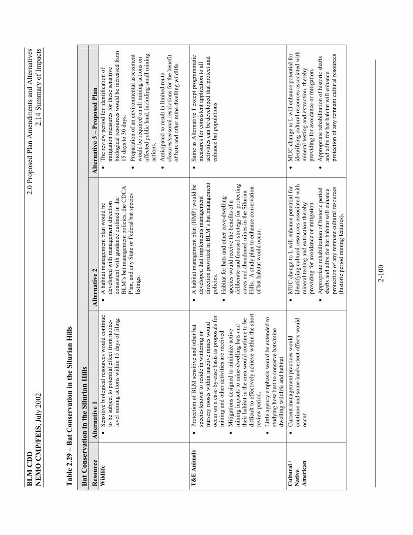
BLM
CD
D2.
0 Pr
opos
ed P
lan
Am
endm
ents
and
Alte
rnat
ives
N
EMO
CM
P/FE
IS, J
uly
2002
2.
14 S
umm
ary
of Im
pact
s
2-10
0
Tab
le 2
.29
– B
at C
onse
rvat
ion
in th
e Si
luri
an H
ills
Bat
Con
serv
atio
n in
the
Silu
rian
Hill
s R
esou
rce
Alte
rnat
ive
1 A
ltern
ativ
e 2
Alte
rnat
ive
3 –
Prop
osed
Pla
n W
ildlif
e ��
Sens
itive
bio
logi
cal r
esou
rces
wou
ld c
ontin
ue
to b
e su
bjec
t to
pote
ntia
l effe
ct fr
om n
otic
e-le
vel m
inin
g ac
tions
with
in 1
5 da
ys o
f fili
ng.
��
A h
abita
t man
agem
ent p
lan
wou
ld b
e de
velo
ped
with
man
agem
ent d
irect
ion
cons
iste
nt w
ith g
uida
nce
outli
ned
in th
e B
LM’s
bat
man
agem
ent p
olic
ies,
the
CD
CA
Pl
an, a
nd a
ny S
tate
or F
eder
al b
at sp
ecie
s lis
tings
.
��
The
revi
ew p
erio
d fo
r ide
ntifi
catio
n of
m
itiga
tion
mea
sure
s for
thes
e se
nsiti
ve
biol
ogic
al re
sour
ces w
ould
be
incr
ease
d fro
m
15 d
ays t
o 30
day
s. ��
Prep
arat
ion
of a
n en
viro
nmen
tal a
sses
smen
t w
ould
be
requ
ired
on a
ll m
inin
g ac
tions
on
affe
cted
pub
lic la
nd, i
nclu
ding
smal
l min
ing
actio
ns.
��
Ant
icip
ated
to re
sult
in li
mite
d ro
ute
clos
ures
/sea
sona
l res
trict
ions
for t
he b
enef
it of
bat
s and
oth
er m
ine
dwel
ling
wild
life.
T&E
Ani
mal
s ��
Prot
ectio
n of
BLM
sens
itive
and
oth
er b
at
spec
ies k
now
n to
resi
de in
win
terin
g or
nu
rser
y ro
osts
with
in in
activ
e m
ines
wou
ld
occu
r on
a ca
se-b
y-ca
se b
asis
as p
ropo
sals
for
min
ing
and
othe
r act
iviti
es a
re re
ceiv
ed.
��
Miti
gatio
ns d
esig
ned
to m
inim
ize
activ
e m
inin
g im
pact
s to
min
e-dw
ellin
g ba
ts a
nd
thei
r hab
itat i
n th
e ar
ea w
ould
con
tinue
to b
e di
fficu
lt to
effe
ctiv
ely
achi
eve
with
in th
e sh
ort
revi
ew p
erio
d.
��
Littl
e ag
ency
em
phas
is w
ould
be
exte
nded
to
stud
ying
how
bes
t to
cons
erve
bat
s/m
ine
dwel
ling
wild
life
and
habi
tat
��
A h
abita
t man
agem
ent p
lan
(HM
P) w
ould
be
deve
lope
d th
at im
plem
ents
man
agem
ent
dire
ctio
n pr
ovid
ed in
BLM
’s b
at m
anag
emen
t po
licie
s. ��
Hab
itat f
or b
ats a
nd o
ther
cav
e-dw
ellin
g sp
ecie
s wou
ld re
ceiv
e th
e be
nefit
s of a
de
liber
ate
and
focu
sed
stra
tegy
for p
rote
ctin
g ca
ves a
nd a
band
oned
min
es in
the
Silu
rian
Hill
s. A
stud
y pl
an to
enh
ance
con
serv
atio
n of
bat
hab
itat w
ould
occ
ur.
��
Sam
e as
Alte
rnat
ive
1 ex
cept
pro
gram
mat
ic
mea
sure
s for
con
sist
ent a
pplic
atio
n to
all
activ
ities
can
be
deve
lope
d th
at p
rote
ct a
nd
enha
nce
bat p
opul
atio
ns
Cul
tura
l /
Nat
ive
Am
eric
an
��
Cur
rent
man
agem
ent p
ract
ices
wou
ld
cont
inue
and
som
e in
adve
rtent
aff
ects
wou
ld
occu
r.
��
MU
C c
hang
e to
L w
ill e
nhan
ce p
oten
tial f
or
iden
tifyi
ng c
ultu
ral r
esou
rces
ass
ocia
ted
with
m
iner
al te
stin
g an
d ex
tract
ion
ther
eby
prov
idin
g fo
r avo
idan
ce o
r miti
gatio
n.
��
App
ropr
iate
reha
bilit
atio
n of
his
toric
per
iod
shaf
ts a
nd a
dits
for b
at h
abita
t will
enh
ance
pr
otec
tion
of a
ny re
mna
nt c
ultu
ral r
esou
rces
(h
isto
ric p
erio
d m
inin
g fe
atur
es).
��
MU
C c
hang
e to
L w
ill e
nhan
ce p
oten
tial f
or
iden
tifyi
ng c
ultu
ral r
esou
rces
ass
ocia
ted
with
m
iner
al te
stin
g an
d ex
tract
ion,
ther
eby
prov
idin
g fo
r avo
idan
ce o
r miti
gatio
n.
��
App
ropr
iate
reha
bilit
atio
n of
his
toric
shaf
ts
and
adits
for b
at h
abita
t will
enh
ance
pr
otec
tion
of a
ny re
mna
nt c
ultu
ral r
esou
rces

BLM
CD
D2.
0 Pr
opos
ed P
lan
Am
endm
ents
and
Alte
rnat
ives
N
EMO
CM
P/FE
IS, J
uly
2002
2.
14 S
umm
ary
of Im
pact
s
2-10
1
Bat
Con
serv
atio
n in
the
Silu
rian
Hill
s R
esou
rce
Alte
rnat
ive
1 A
ltern
ativ
e 2
Alte
rnat
ive
3 –
Prop
osed
Pla
n R
ecre
atio
n ��
Bat
gra
tes m
ay b
e us
ed o
n so
me
cave
s with
ba
t mat
erni
ty ro
osts
, int
erfe
ring
with
cav
e ex
plor
atio
n op
portu
nitie
s.
��
Non
-mot
oriz
ed b
uffe
rs a
roun
d so
me
inac
tive
min
es c
ould
lim
it re
crea
tiona
l opp
ortu
nitie
s fo
r roc
khou
nder
s, an
d hi
stor
ic se
eker
s. ��
Bat
gra
tes w
ould
con
tinue
to b
e us
ed.
��
Impa
cts a
re th
e sa
me
as A
ltern
ativ
e 2.
Min
eral
s &
Min
ing
��
A p
lan
of o
pera
tions
and
a 3
0 da
y pr
oces
sing
pe
riod
are
requ
ired
for s
ampl
ing/
min
ing
over
1,
000
tons
. Fi
nanc
ial a
ssur
ance
s are
requ
ired
for b
oth
notic
es a
nd p
lans
of o
pera
tions
. The
re
quire
men
t for
bat
gat
es is
an
insig
nific
ant
incr
ease
ove
r cos
t of n
orm
al g
ates
to k
eep
out
hum
ans f
or sa
fety
reas
ons.
��
Proc
essi
ng ti
me
wou
ld b
e 30
inste
ad o
f 15
days
for s
ampl
ing
less
than
1,0
00 to
ns.
��
BLM
wou
ld b
ear t
he b
urde
n of
con
duct
ing
surv
eys a
nd re
mov
ing
bats
with
in re
gula
tory
tim
efra
mes
. ��
Ove
rall
impa
cts o
n m
inin
g w
ould
not
be
sign
ifica
ntly
gre
ater
than
Alte
rnat
ive
1.
��
Sam
e as
Alte
rnat
ive
2.
Veh
icle
Acc
ess
��
Few
impa
cts t
o ve
hicl
e ac
cess
are
ant
icip
ated
fro
m th
e N
o A
ctio
n A
ltern
ativ
e ��
Acc
ess o
n ex
istin
g ro
utes
of t
rave
l with
lo
caliz
ed re
stric
tions
to v
ehic
ular
acc
ess w
ill
occu
r, ba
sed
on se
nsiti
ve re
sour
ces w
hen
iden
tifie
d. T
he n
etw
ork
of ro
utes
ava
ilabl
e fo
r cas
ual m
otor
ized
use
will
con
tinue
to
prov
ide
reas
onab
le a
cces
s thr
ough
out t
he
plan
ning
are
a
��
Alte
rnat
ive
2 w
ould
resu
lt in
min
or to
m
oder
ate
nega
tive
impa
cts t
o ve
hicl
e ac
cess
ba
sed
on ro
ute
clos
ures
and
seas
onal
lim
itatio
ns id
entif
ied
durin
g H
MP
plan
ning
. A
dditi
onal
pub
lic in
put w
ould
occ
ur a
t tha
t tim
e.
��
Impa
cts
wou
ld b
e si
mila
r to
Alte
rnat
ive
2, b
ut
may
be
less
, sin
ce ro
ute
desi
gnat
ion
will
not
be
look
ed a
t thr
ough
an
HM
P

BLM
CD
D2.
0 Pr
opos
ed P
lan
Am
endm
ents
and
Alte
rnat
ives
N
EMO
CM
P/FE
IS, J
uly
2002
2.
14 S
umm
ary
of Im
pact
s
2-10
2
Tabl
e 2.
30 –
CD
CA
Pla
n M
aint
enan
ce A
ctio
ns
CD
CA
Pla
n M
aint
enan
ce A
ctio
ns
Res
ourc
e A
ltern
ativ
e 1
Alte
rnat
ive
2 A
ltern
ativ
e 3
– Pr
opos
ed P
lan
Veg
etat
ion
��
Ther
e w
ould
be
no d
irect
impa
cts o
n na
tura
l res
ourc
es u
sing
the
CD
CA P
lan
MU
C g
uida
nce
for r
elea
sed
land
s.��
Pote
ntia
l for
indi
rect
impa
cts
wou
ld
cont
inue
to o
ccur
with
less
opp
ortu
nity
fo
r miti
gatio
n fo
r sm
all m
inin
g ac
tions
in
MU
C M
are
as.
��
Indi
rect
ben
efic
ial i
mpa
cts f
rom
rout
e de
sign
atio
n in
MU
C L
are
as c
an b
e an
ticip
ated
, par
ticul
arly
in w
ashe
s.
��
Impa
cts
wou
ld b
e si
mila
r to
Alte
rnat
ive
1 ex
cept
that
the
cum
ulat
ive
addi
tion
of
85,4
50 a
cres
in M
UC
L w
ould
resu
lt in
po
tent
ial b
enef
icia
l im
pact
s on
thos
e la
nds,
as d
iscu
ssed
und
er N
o A
ctio
n A
ltern
ativ
e.
��
Impa
cts
wou
ld b
e si
mila
r to
Alte
rnat
ive
1 (N
o A
ctio
n) e
xcep
t tha
t the
cum
ulat
ive
addi
tion
of 7
6,97
0 ac
res i
n M
UC
M
wou
ld re
sult
in p
oten
tial b
enef
icia
l im
pact
s on
thos
e la
nds,
as d
iscu
ssed
un
der N
o A
ctio
n
Nox
ious
Wee
ds
��
See
abov
e��
See
abov
e��
See
abov
eW
etla
nds &
Rip
aria
n ��
See
abov
e��
See
abov
e��
See
abov
eEx
istin
g A
CEC
s ��
See
abov
e��
See
abov
e��
See
abov
eW
ildlif
e ��
See
abov
e ��
See
abov
e��
See
abov
eT&
E A
nim
als
��
See
abov
e ��
See
abov
e ��
See
abov
e Ex
istin
g A
CEC
s ��
See
abov
e��
See
abov
e��
See
abov
eSo
il, W
ater
, Air
��
See
abov
e��
See
abov
e ��
See
abov
eW
ater
Qua
lity/
Qua
ntity
��
See
abov
e��
See
abov
e��
See
abov
eC
ultu
ral/N
ativ
e A
mer
ican
��
No
dire
ct im
pact
s ��
Indi
rect
affe
cts i
n si
x sm
all a
reas
tota
ling
17,5
00 a
cres
pre
viou
sly
reco
mm
ende
d as
w
ilder
ness
land
and
man
aged
in M
UC
C.
��
No
dire
ct im
pact
s.��
Indi
rect
affe
cts i
n si
x sm
all a
reas
tota
ling
17,5
00 a
cres
wou
ld b
e th
e sa
me
as
Alte
rnat
ive
1.
��
Sim
ilar t
o A
ltern
ativ
e 1
wou
ld n
ot a
ffect
cu
ltura
l res
ourc
es if
in c
onfo
rman
ce w
ith
CD
PA.
��
Indi
rect
affe
cts i
n si
x sm
all a
reas
tota
ling
17,5
00 a
cres
wou
ld b
e th
e sa
me
as
Alte
rnat
ive
1.
Rec
reat
ion
��
No
Impa
cts
��
No
Impa
cts
��
No
Impa
cts

BLM
CD
D2.
0 Pr
opos
ed P
lan
Am
endm
ents
and
Alte
rnat
ives
N
EMO
CM
P/FE
IS, J
uly
2002
2.
14 S
umm
ary
of Im
pact
s
2-10
3
CD
CA
Pla
n M
aint
enan
ce A
ctio
ns
Res
ourc
e A
ltern
ativ
e 1
Alte
rnat
ive
2 A
ltern
ativ
e 3
– Pr
opos
ed P
lan
Min
eral
s & M
inin
g ��
Alte
rnat
e 1
cum
ulat
ivel
y w
ould
be
mor
e fa
vora
ble
than
Alte
rnat
e 2
or 3
, as i
t w
ould
pro
vide
for m
ore
rele
ased
po
lygo
ns to
retu
rn to
MU
C M
. Th
e ad
vant
age
wou
ld b
e th
e gr
eate
r ap
plic
abili
ty o
f Not
ice
leve
l act
ivity
, in
clud
ing
in a
reas
with
hig
her m
iner
al
pote
ntia
l. O
n a
site
-spe
cific
bas
is, t
he
othe
r alte
rnat
ives
may
be
pref
erab
le
��
Sim
ilar t
o A
ltern
ativ
e 1
exce
pt th
at th
e ad
ditio
n of
85,
450
acre
s in
MU
C L
w
ould
resu
lt in
pot
entia
l neg
ativ
e im
pact
s to
smal
l exp
lora
tory
min
ing
activ
ities
on
thos
e la
nds,
as d
iscu
ssed
und
er N
o A
ctio
n A
ltern
ativ
e. O
n a
parc
el-b
y-pa
rcel
ba
sis,
this
Alte
rnat
ive
wou
ld b
e po
tent
ially
mor
e m
iner
al e
xplo
ratio
n fri
endl
y in
8 a
reas
, and
par
tially
so in
an
othe
r 4 a
reas
. It
wou
ld b
e le
ss m
iner
al
expl
orat
ion
frien
dly
in 8
are
as, a
nd
parti
ally
so in
4 a
reas
.
��
Sam
e as
Alte
rnat
ive1
exce
pt th
at th
e ad
ditio
n of
76,
970
acre
s in
MU
C L
w
ould
resu
lt in
crea
sed
proc
essi
ng ti
me
from
15
to 3
0 da
ys fo
r sam
plin
g le
ss th
an
1,00
0 to
ns o
n th
ose
land
s, as
dis
cuss
ed
unde
r No
Act
ion.
The
Pro
pose
d Pl
an
Alte
rnat
ive
wou
ld b
e sl
ight
ly m
ore
bene
ficia
l to
min
ing
than
Alte
rnat
ive
2 on
a
per a
cre
basi
s. O
n a
parc
el-b
y-pa
rcel
ba
sis,
this
Alte
rnat
ive
wou
ld b
e po
tent
ially
mor
e m
iner
al e
xplo
ratio
n fri
endl
y in
2 a
reas
than
no
actio
n. I
t w
ould
be
less
min
eral
exp
lora
tion
frien
dly
than
no
actio
n in
5 a
reas
, and
pa
rtial
ly so
in 4
are
as.
Veh
icle
Acc
ess
��
Ove
rall
rout
e de
sign
atio
n ca
n be
exp
ecte
d to
resu
lt in
few
er o
pen
rout
es o
n re
leas
ed
land
s ide
ntifi
ed a
s MU
C L
, but
this
may
va
ry o
n a
site
-spe
cific
bas
is.
��
Sam
e as
Alte
rnat
ive
1. T
he a
dditi
on o
f 85
,450
acr
es in
MU
C L
cou
ld re
sult
in
pote
ntia
l add
ition
al li
mita
tions
to a
cces
s du
ring
rout
e de
sign
atio
n on
thos
e la
nds,
as d
iscu
ssed
und
er N
o A
ctio
n. O
n a
parc
el b
y pa
rcel
bas
is, t
his A
ltern
ativ
e w
ould
be
pote
ntia
lly m
ore
acce
ss fr
iend
ly
in 8
are
as, a
nd p
artia
lly so
in 4
are
as.
It w
ould
be
less
acc
ess f
riend
ly in
8 a
reas
, an
d pa
rtial
ly so
in 4
are
as.
��
Sam
e as
Alte
rnat
ive 1
. The
add
ition
of
76,9
70 a
cres
in M
UC
L c
ould
resu
lt in
po
tent
ial a
dditi
onal
lim
itatio
ns to
acc
ess
durin
g ro
ute
desi
gnat
ion
on th
ose
land
s, as
dis
cuss
ed u
nder
No
Act
ion.
On
a pa
rcel
-by-
parc
el b
asis
, thi
s Alte
rnat
ive
wou
ld b
e pa
rtial
ly m
ore
acce
ss fr
iend
ly
in 2
are
as.
It w
ould
be
less
acc
ess
frien
dly
in 5
are
as, a
nd p
artia
lly so
in
anot
her 4
are
as.

BLM
CD
D2.
0 Pr
opos
ed P
lan
Am
endm
ents
and
Alte
rnat
ives
N
EMO
CM
P/FE
IS, J
uly
2002
2.
14 S
umm
ary
of Im
pact
s
2-10
4
Tabl
e 2.
31 –
Gre
enw
ater
Can
yon
AC
EC D
elet
ion
Prop
osal
Res
ourc
e A
ltern
ativ
e 1
– N
o A
ctio
n A
ltern
ativ
e 2
– Pr
opos
ed P
lan
Cul
tura
l/Nat
ive
Am
eric
an
��
No
chan
ges t
o ex
istin
g si
tuat
ion
unde
r Alte
rnat
ive
1. M
anag
e un
der e
xist
ing
AC
EC M
anag
emen
t Pl
an.
��
No
know
n si
gnifi
cant
site
s wou
ld b
e im
pact
ed.
As y
et u
nide
ntifi
ed c
ultu
ral
reso
urce
s with
in th
e re
mai
ning
por
tion
of th
e A
CEC
wou
ld b
e m
anag
ed u
nder
M
UC
L g
uide
lines
. M
iner
als &
Min
ing
��
Min
eral
act
iviti
es in
the
area
cur
rent
ly re
quire
pl
ans o
f ope
ratio
n an
d sp
ecia
l miti
gatio
n st
rate
gies
to
pre
vent
impa
cts t
o an
y cu
ltura
l res
ourc
es.
��
Impa
cts a
re si
mila
r to
Alte
rnat
ive
1. M
inin
g ac
tions
on
BLM
land
s wou
ld b
e m
anag
ed u
nder
MU
C L
gui
delin
es, r
equi
ring
a Pl
an o
f Ope
ratio
ns a
nd
proc
essi
ng ti
me
of 3
0 da
ys.
Spec
ial m
itiga
tion
spec
ific
to a
n A
CEC
wou
ld n
ot
be im
pose
d, b
ut if
a “
may
affe
ct”
to si
gnifi
cant
cul
tura
l res
ourc
es o
ccur
s, ad
ditio
nal m
itiga
tion
and
cons
ulta
tion
wou
ld b
e re
quire
d.
Rec
reat
ion
��
Ver
y fe
w ro
utes
of t
rave
l. M
inim
al E
ffect
. ��
Som
ewha
t inc
reas
ed re
crea
tion
in G
reen
wat
er C
anyo
n, in
clud
ing
cam
ping
ad
jace
nt to
the
mai
n op
en ro
ute
thro
ugh
the
cany
on (i
n di
sturb
ed a
reas
with
in
300
feet
of t
he ro
ute)
.

BLM
CD
D2.
0 Pr
opos
ed P
lan
Am
endm
ents
and
Alte
rnat
ives
N
EMO
CM
P/FE
IS, J
uly
2002
2.
14 S
umm
ary
of Im
pact
s
2-10
5
Tab
le 2
.32
– O
rgan
ized
Com
petit
ive
Veh
icle
Eve
nts
Org
aniz
ed C
ompe
titiv
e V
ehic
le E
vent
s R
esou
rce
Alte
rnat
ive
1 A
ltern
ativ
e 2
Alte
rnat
ive
3
Alte
rnat
ive
4 A
ltern
ativ
e 5
Prop
osed
Pla
n
Veg
etat
ion
��
Dis
turb
ance
of s
oil s
truct
ure
supp
ortin
g ve
geta
tion,
pro
mot
ion
of w
eedy
spec
ies
thro
ugh
surfa
ce d
istu
rban
ce, l
oss o
f soi
l af
ter l
oss o
f soi
l-hol
ding
cry
ptog
amic
cru
sts,
loss
of s
eeds
in th
e so
il, a
nd re
duct
ion
of
soil
moi
stur
e th
roug
h co
mpa
ctio
n.
��
Non
-nat
ive
inva
sive
pla
nts a
lso
pose
an
incr
ease
d po
tent
ial f
or la
rger
fire
s.
��
Cou
rse
wid
enin
g co
uld
have
subs
tant
ial
effe
cts o
n ve
geta
tive
com
posi
tion.
��
Dat
a co
llect
ed in
are
as o
utsid
e de
sert
torto
ise
habi
tat w
here
the
perm
itted
cou
rse
wid
th w
as 1
00 fe
et sh
owed
that
stra
ying
and
co
urse
wid
enin
g oc
curr
ed.
The
race
cou
rse
wid
th in
the
area
to th
e w
est o
f a p
it ar
ea
was
mea
sure
d at
260
feet
and
nea
r So
lom
ons K
nob
seve
ral t
rans
ects
not
ed ra
ce
vehi
cle
track
s ove
r 90
feet
out
side
the
perm
itted
cou
rse
wid
th.
��
As a
resu
lt of
shor
tcut
ting
and
over
runn
ing
in w
ashe
s, th
e 19
89 e
vent
cau
sed
exte
nsiv
e da
mag
e to
veg
etat
ion
and
brea
kdow
n of
w
ash
bank
s. ��
Hig
her t
han
norm
al le
vels
of d
ust o
n le
af
surfa
ces m
ay re
duce
coo
ling
effic
ienc
y of
th
e pl
ants
and
cau
se a
dded
stre
ss.
��
Cru
shin
g of
ve
geta
tion
alon
g co
urse
s wou
ld n
ot
occu
r.
��
Cha
nges
in sp
ecie
s co
mpo
sitio
n w
ould
be
subs
tant
ially
re
duce
d.
��
Impa
cts w
ould
be
sim
ilar t
o th
ose
desc
ribed
in
Alte
rnat
ive
1 ou
tsid
e of
DW
MA
s ��
With
in D
WM
As,
impa
cts w
ould
be
the
sam
e as
A
ltern
ativ
e 2.
��
Impa
cts w
ould
be
the
sam
e as
A
ltern
ativ
e 3,
be
caus
e so
me
even
ts w
ould
st
ill b
e he
ld
outs
ide
of O
HV
op
en a
reas
.
��
The
impa
cts o
f thi
s al
tern
ativ
e w
ithin
th
e D
umon
t Dun
es
off-h
ighw
ay
vehi
cle
“Ope
n”
area
wou
ld b
e th
e sa
me
as A
ltern
ativ
e 1
for a
ll re
sour
ces.
��
The
impa
cts i
n al
l ot
her a
reas
of t
he
NEM
O p
lann
ing
area
wou
ld b
e th
e sa
me
as A
ltern
ativ
e 2
for a
ll re
sour
ces.

BLM
CD
D2.
0 Pr
opos
ed P
lan
Am
endm
ents
and
Alte
rnat
ives
N
EMO
CM
P/FE
IS, J
uly
2002
2.
14 S
umm
ary
of Im
pact
s
2-10
6
Org
aniz
ed C
ompe
titiv
e V
ehic
le E
vent
s R
esou
rce
Alte
rnat
ive
1 A
ltern
ativ
e 2
Alte
rnat
ive
3
Alte
rnat
ive
4 A
ltern
ativ
e 5
Prop
osed
Pla
n
T&E
Plan
ts
��
Miti
gatio
n m
easu
res c
omm
only
app
lied
wou
ld p
rohi
bit r
aces
on
rout
es tr
aver
sing
kn
own
habi
tat o
f spe
cial
stat
us p
lant
s.
How
ever
, inv
ento
ries o
f spe
cial
stat
us p
lant
s ar
e in
com
plet
e.
��
The
risk
of d
amag
e to
spec
ial s
tatu
s pl
ants
or t
heir
habi
tat f
rom
ride
rs,
spec
tato
rs, a
nd p
re-
even
t rid
ers w
ould
be
rem
oved
��
Impa
cts w
ould
be
sim
ilar t
o A
lt 1
outs
ide
of D
WM
As
but t
he ri
sk o
f ha
ving
an
even
t in
habi
tat o
f a sp
ecia
l st
atus
pla
nt w
ould
be
redu
ced.
Som
e ris
k w
ould
rem
ain
beca
use
sens
itive
pl
ant i
nven
torie
s are
in
com
plet
e.
��
With
in D
WM
As,
impa
cts w
ould
be
the
sam
e as
Alt
2.
��
Impa
cts w
ould
be
the
sam
e as
A
ltern
ativ
e 3.
Impa
cts w
ould
be
the
sam
e as
Alte
rnat
ive
2
N
oxio
us
Wee
ds
��
Alth
ough
mos
t of t
hese
impa
cts (
e.g.
, soi
l pr
ofile
dis
rupt
ion
and
com
pact
ion,
ge
rmin
atio
n an
d co
ver s
ite m
odifi
catio
n,
and
forb
and
shru
b lo
ss) w
ould
be
limite
d to
th
e ev
ent c
ours
e its
elf,
the
pote
ntia
l for
sp
read
of i
nvas
ive
non-
nativ
e pl
ants
and
ve
geta
tive
type
-con
vers
ion
wou
ld e
xten
d be
yond
the
race
cou
rse.
��
Impa
cts w
ould
be
the
sam
e as
A
ltern
ativ
e 2
of
Stan
dard
s and
G
uide
lines
. ��
Nox
ious
wee
ds
wou
ld n
ot b
e pr
omot
ed b
y ra
cing
ac
tiviti
es.
��
Impa
cts w
ould
be
the
sam
e as
A
ltern
ativ
e 1
but
they
wou
ld o
ccur
ou
tsid
e of
the
DW
MA
s.
��
Impa
cts w
ould
be
the
sam
e as
A
ltern
ativ
e 3,
be
caus
e so
me
even
ts w
ould
be
outs
ide
the
OH
V
open
are
as.
Impa
cts w
ould
be
the
sam
e as
Alte
rnat
ive
2
W
etla
nds,
Rip
aria
n &
Fl
oodp
lain
s
��
No
impa
cts w
ould
occ
ur b
ecau
se th
ere
are
no ri
paria
n ar
eas.
��
Impa
cts w
ould
be
the
sam
e as
A
ltern
ativ
e 1.
��
Impa
cts w
ould
be
the
sam
e as
A
ltern
ativ
e 1.
��
Subs
tant
ial
stra
tegi
es w
ould
be
nec
essa
ry if
a
feas
ible
al
ignm
ent i
s fo
und.
Impa
cts w
ould
be
the
sam
e as
Alte
rnat
ive
2

BLM
CD
D2.
0 Pr
opos
ed P
lan
Am
endm
ents
and
Alte
rnat
ives
N
EMO
CM
P/FE
IS, J
uly
2002
2.
14 S
umm
ary
of Im
pact
s
2-10
7
Org
aniz
ed C
ompe
titiv
e V
ehic
le E
vent
s R
esou
rce
Alte
rnat
ive
1 A
ltern
ativ
e 2
Alte
rnat
ive
3
Alte
rnat
ive
4 A
ltern
ativ
e 5
Prop
osed
Pla
n
Wild
life
��
Loss
of f
orag
e, c
hang
es in
fora
ge sp
ecie
s co
mpo
sitio
n, a
nd lo
ss o
f cov
er w
ould
resu
lt fro
m d
istu
rban
ce o
f veg
etat
ion.
��
Ani
mal
s can
be
run
over
abo
ve g
roun
d or
be
low
gro
und.
Soi
l com
pact
ion
disr
upts
bu
rrow
suita
bilit
y. I
n ge
nera
l, it
can
be
expe
cted
that
spec
ies d
iver
sity
wou
ld b
e re
duce
d al
ong
race
rout
es w
here
veg
etat
ion
and
soil
distu
rban
ces o
ccur
. ��
Wild
life
activ
ities
wou
ld b
e di
srup
ted
on th
e sh
ort t
erm
, and
cou
ld in
clud
e no
t onl
y th
e ra
ce e
vent
but
als
o pr
e-rid
ing
of th
e co
urse
as
par
ticip
ants
pra
ctic
e.
��
Cha
nges
in b
ehav
ior p
atte
rns c
ould
occ
ur.
��
Wild
life
may
be
inju
red
or k
illed
. ��
Hab
itat d
egra
datio
n co
uld
occu
r.
��
This
alte
rnat
ive
wou
ld b
enef
it w
ildlif
e sp
ecie
s, as
di
stur
banc
es w
ould
be
rem
oved
.
��
Rem
oval
of r
acin
g w
ould
allo
w fo
r co
ntin
ued
soil
and
vege
tatio
n re
cove
ry.
��
Deg
rada
tion
of
habi
tat a
long
ra
ceco
urse
s wou
ld
not o
ccur
. Th
ese
and
othe
r effe
cts
desc
ribed
mor
e fu
lly
in A
ltern
ativ
e 1
wou
ld n
ot o
ccur
.
��
Impa
cts w
ould
be
sim
ilar t
o th
ose
desc
ribed
in
Alte
rnat
ive
1.
Impo
rtant
wild
life
habi
tat w
ould
be
avoi
ded.
��
Insi
de o
f DW
MA
s, im
pact
s wou
ld b
e si
mila
r to
Alte
rnat
ive
2.
��
The
effe
cts
wou
ld b
e si
mila
r to
Alte
rnat
ive
3,
but a
dditi
onal
im
pact
s to
ripar
ian
habi
tat
may
occ
ur.
��
Impa
cts w
ould
be
the
sam
e as
A
ltern
ativ
e 2

BLM
CD
D2.
0 Pr
opos
ed P
lan
Am
endm
ents
and
Alte
rnat
ives
N
EMO
CM
P/FE
IS, J
uly
2002
2.
14 S
umm
ary
of Im
pact
s
2-10
8
Org
aniz
ed C
ompe
titiv
e V
ehic
le E
vent
s R
esou
rce
Alte
rnat
ive
1 A
ltern
ativ
e 2
Alte
rnat
ive
3
Alte
rnat
ive
4 A
ltern
ativ
e 5
Prop
osed
Pla
n
T&E
��
Whe
re e
vent
s pas
s thr
ough
hab
itat o
f a
liste
d an
imal
, the
re is
pot
entia
l for
a ta
ke
thro
ugh
harm
or h
aras
smen
t,
��
Hab
itat l
oss f
or sp
ecia
l sta
tus a
nim
als,
espe
cial
ly d
eser
t tor
tois
e, is
a re
sult
of
fact
ors d
escr
ibed
in th
e di
scus
sion
of
Gen
eral
Veg
etat
ion
abov
e.
��
Hea
vily
use
d ro
ute
cour
ses p
rovi
de fo
r in
vasi
on o
f wee
dy sp
ecie
s, w
hich
in tu
rn
may
resu
lt in
type
-con
verte
d ar
eas t
hat
prov
ide
redu
ced
cove
r for
hat
chlin
g an
d ju
veni
le to
rtois
es, m
akin
g th
em su
scep
tible
to
pre
datio
n an
d de
ath
from
exp
osur
e. T
he
resu
lts a
re a
reas
of r
educ
ed to
rtoise
den
sity
. ��
The
wid
enin
g of
the
cour
se m
ay c
ontri
bute
to
hab
itat f
ragm
enta
tion.
��
Torto
ise
burro
ws m
ay b
e cr
ushe
d ��
Sens
itive
spec
ies s
uch
as b
igho
rn sh
eep,
bu
rrow
ing
owls
and
bat
s, ar
e lik
ely
to b
e im
pact
ed, r
angi
ng fr
om te
mpo
rary
di
spla
cem
ent f
rom
hab
itat t
o co
mpl
ete
area
av
oida
nce.
��
This
alte
rnat
ive
wou
ld b
enef
it th
e de
sert
torto
ise
and
poss
ibly
oth
er
spec
ial s
tatu
s an
imal
s by
rem
ovin
g po
tent
ial
for d
irect
mor
talit
y fro
m ru
nove
rs a
nd
by fa
cilit
atin
g co
ntin
ued
soil
and
vege
tativ
e re
cove
ry.
��
Impa
cts w
ould
be
sim
ilar t
o th
ose
desc
ribed
in
Alte
rnat
ive
2,
exce
pt a
reas
out
side
of
DW
MA
s cou
ld
cont
inue
to re
ceiv
e im
pact
s if a
via
ble
cour
se is
iden
tifie
d.
��
Ther
e is
a h
igh
pote
ntia
l for
ta
ke o
f the
de
sert
torto
ise
by a
com
petit
ive
even
t hel
d in
a
narr
ow w
ash
such
as
Kin
gsto
n.
Thou
gh n
ot
desi
gnat
ed a
s cr
itica
l hab
itat
for t
he sp
ecie
s, th
is w
ash
may
ac
t as a
n im
porta
nt
habi
tat l
inka
ge
betw
een
dese
rt to
rtois
e po
pula
tions
in
the
East
and
W
est M
ojav
e.
Impa
cts o
n to
rtois
e ar
e si
mila
r to
Alt
3.
��
Sens
itive
pla
nt
spec
ies m
ay b
e im
pact
ed
beca
use
som
e ev
ents
may
be
held
out
side
OH
V o
pen
area
s.
��
Impa
cts w
ould
be
the
sam
e as
A
ltern
ativ
e 2.

BLM
CD
D2.
0 Pr
opos
ed P
lan
Am
endm
ents
and
Alte
rnat
ives
N
EMO
CM
P/FE
IS, J
uly
2002
2.
14 S
umm
ary
of Im
pact
s
2-10
9
Org
aniz
ed C
ompe
titiv
e V
ehic
le E
vent
s R
esou
rce
Alte
rnat
ive
1 A
ltern
ativ
e 2
Alte
rnat
ive
3
Alte
rnat
ive
4 A
ltern
ativ
e 5
Prop
osed
Pla
n
Soil,
Wat
er, A
ir
��
Soil
dist
urba
nce
and
rem
oval
of v
eget
atio
n as
soci
ated
with
use
of a
com
petit
ive
race
cour
se w
ould
resu
lt in
incr
ease
d w
ind
and
wat
er e
rosi
on o
f aff
ecte
d so
ils.
Red
uced
soil
perm
eabi
lity
/wat
er st
orag
e po
tent
ial a
nd c
ompa
ctio
n w
ithin
the
race
cour
se w
ould
also
occ
ur w
ith su
ch u
se
over
tim
e. L
evel
s of i
mpa
ct w
ould
diff
er
depe
ndin
g on
allo
wed
race
cour
se w
idth
, sp
ecifi
c ra
ceco
urse
segm
ent,
and
frequ
ency
/tim
ing
of u
se.
��
Soil
impa
cts a
ssoc
iate
d w
ith p
ast e
vent
s w
ere
dete
rmin
ed to
be,
a re
duct
ion
in d
eser
t pa
vem
ent c
over
age
and
incr
ease
d de
velo
pmen
t of s
oft,
pow
der-
like
mat
eria
ls
that
are
ver
y su
scep
tible
to w
ind
and
wat
er
eros
ion.
��
Soi
l nut
rient
leve
ls a
re e
xpec
ted
to d
ecre
ase
over
the
long
term
due
to th
e re
mov
al o
f the
ve
geta
tive
cove
r, fro
m th
e ch
urni
ng o
f the
so
il su
rface
by
race
traf
fic, a
nd th
roug
h th
e m
ixin
g of
nut
rient
poo
r soi
ls w
ith th
e m
ore
ferti
le so
ils a
ssoc
iate
d w
ith “
plan
t isl
ands
.”
��
Tem
pora
ry in
crea
se in
the
amou
nt o
f ox
idan
ts a
nd c
arbo
n m
onox
ide
alon
g th
e co
urse
. ��
Air
qual
ity st
anda
rds f
or P
M10
wou
ld b
e te
mpo
raril
y ex
ceed
ed b
ased
on
mea
sure
men
t of t
otal
susp
ende
d pa
rticu
late
s. ��
The
atm
osph
ere
surr
ound
ing
the
even
t w
ould
be
impa
cted
by
the
gene
ratio
n of
dus
t an
d te
mpo
rary
em
issi
ons r
esul
t in
a sh
ort-
term
(app
roxi
mat
ely
14 h
ours
) red
uctio
n in
ai
r qua
lity.
��
Mod
erat
e in
crea
ses
in sh
ort-t
erm
air
qual
ity a
nd so
il im
pact
s in
OH
V
open
are
as w
ould
oc
cur a
s a re
sult
of
disp
lace
d ra
cing
ac
tivity
.
��
Impa
cts a
re th
e sa
me
as A
ltern
ativ
e 1.
��
Impa
cts a
re
sim
ilar t
o A
ltern
ativ
e 3.
K
ings
ton
Was
h so
ils h
ave
a re
lativ
ely
low
po
tent
ial f
or
win
d er
osio
n in
co
mpa
rison
to
the
orig
inal
B
arst
ow-to
-V
egas
cou
rse,
al
ong
the
Bou
lder
C
orrid
or.
��
Impa
cts a
re th
e sa
me
as A
ltern
ativ
e 2.

BLM
CD
D2.
0 Pr
opos
ed P
lan
Am
endm
ents
and
Alte
rnat
ives
N
EMO
CM
P/FE
IS, J
uly
2002
2.
14 S
umm
ary
of Im
pact
s
2-11
0
Org
aniz
ed C
ompe
titiv
e V
ehic
le E
vent
s R
esou
rce
Alte
rnat
ive
1 A
ltern
ativ
e 2
Alte
rnat
ive
3
Alte
rnat
ive
4 A
ltern
ativ
e 5
Prop
osed
Pla
n
Wat
er
Qua
lity/
Qua
ntity
O
n oc
casi
on, a
rtific
ial w
ashe
s are
form
ed d
ue
to so
il er
osio
n an
d al
tere
d w
ater
dra
inag
e al
ong
com
petit
ive
cour
ses p
artic
ular
ly o
n st
eepe
r gra
des.
��
No
Impa
ct
��
Impa
cts a
re th
e sa
me
as A
ltern
ativ
e 1.
��
Impa
cts a
re th
e sa
me
as
Alte
rnat
ive
1.
��
Impa
cts a
re th
e sa
me
as A
ltern
ativ
e 1.
Cul
tura
l/Nat
ive
Am
eric
an
��
Uni
dent
ified
site
s with
in o
r adj
acen
t to
even
t rou
tes m
ay b
e im
pact
ed.
��
Uns
urve
yed
area
s cou
ld b
e su
bjec
t to
impa
ct
from
veh
icle
s tha
t stra
y fro
m th
e co
urse
.
��
Impa
cts a
re th
e sa
me
as A
ltern
ativ
e 1.
��
Impa
cts a
re th
e sa
me
as A
ltern
ativ
e 1.
��
Impa
cts m
ay
occu
r to
two
know
n si
tes t
hat
may
be
elig
ible
fo
r lis
ting
in th
e N
atio
nal
Reg
iste
r of
His
toric
Pla
ces
and
that
may
be
of g
reat
con
cern
to
Nat
ive
Am
eric
ans
��
No
prot
ectio
n is
of
fere
d to
hi
stor
ic ro
utes
an
d tra
ils th
at
may
be
dete
rmin
ed
elig
ible
for
listin
g in
the
NR
HP.
��
Impa
cts a
re th
e sa
me
as A
ltern
ativ
e 1.

BLM
CD
D2.
0 Pr
opos
ed P
lan
Am
endm
ents
and
Alte
rnat
ives
N
EMO
CM
P/FE
IS, J
uly
2002
2.
14 S
umm
ary
of Im
pact
s
2-11
1
Org
aniz
ed C
ompe
titiv
e V
ehic
le E
vent
s R
esou
rce
Alte
rnat
ive
1 A
ltern
ativ
e 2
Alte
rnat
ive
3
Alte
rnat
ive
4 A
ltern
ativ
e 5
Prop
osed
Pla
n
Rec
reat
ion
��
Alth
ough
the
orig
inal
B-to
-V h
as n
ot b
een
run
since
198
9, so
me
shor
ter l
engt
h co
urse
s m
ay b
e vi
able
. ��
Com
petit
ive
even
ts c
an b
e al
low
ed
cons
iste
nt w
ith M
UC
and
Rec
reat
ion
Elem
ent g
uide
lines
of t
he C
DC
A P
lan,
but
it
is d
iffic
ult t
o lo
cate
a su
itabl
e ra
ceco
urse
in
the
NEM
O p
lann
ing
area
due
to re
sour
ce
conf
licts
. ��
Non
-mot
oriz
ed re
crea
tion
wou
ld b
e di
spla
ced
durin
g ev
ents
, pre
para
tion
and
clea
n up
.
��
The
dele
tion
of th
e ra
ce c
ours
e w
ould
ha
ve a
min
imal
ne
gativ
e ef
fect
to
oppo
rtuni
ties f
or
com
petit
ive
vehi
cle
even
ts c
ompa
red
to
Alte
rnat
ive
1.
��
If th
e B
-to-V
cou
rse
is d
elet
ed a
nd n
o pr
ovis
ions
are
mad
e fo
r com
petit
ive
vehi
cle
even
ts
outs
ide
OH
V o
pen
area
s pot
entia
l op
portu
nitie
s for
th
is fo
rm o
f re
crea
tion
coul
d be
cu
mul
ativ
ely
dim
inis
hed.
��
Mor
e co
nflic
ts m
ay
occu
r in
OH
V o
pen
area
s fro
m li
mite
d op
portu
nitie
s es
peci
ally
dur
ing
holid
ay w
eeke
nds.
��
Impa
cts f
rom
the
dele
tion
of th
e B
-to-
V c
ours
e w
ould
be
the
sam
e as
A
ltern
ativ
e 2.
��
This
Alte
rnat
ive
wou
ld a
llow
for
resu
mpt
ion
of lo
ng
dist
ance
poi
nt-to
-po
int c
ompe
titiv
e ev
ents
out
side
of
OH
V o
pen
area
s an
d im
pact
s wou
ld
be p
oten
tially
po
sitiv
e to
m
otor
ized
re
crea
tion.
H
owev
er, a
s with
ot
her a
ltern
ativ
es,
proc
essi
ng
appl
icat
ions
wou
ld
be ti
me
cons
umin
g an
d ha
ve u
ncer
tain
ou
tcom
es b
ased
on
iden
tifie
d re
sour
ce
conf
licts
, in
the
NEM
O p
lann
ing
area
. ��
Non
-mot
oriz
ed
recr
eatio
n w
ould
be
impa
cted
neg
ativ
ely
��
Impa
cts a
re
sim
ilar t
o A
ltern
ativ
e 3
but
appr
oval
of t
he
cour
se w
ould
re
sult
in
addi
tiona
l re
stric
tions
as
soci
ated
with
pr
otec
tion
mea
sure
s for
w
ilder
ness
, T&
E an
d rip
aria
n re
sour
ces,
incl
udin
g sp
eed
limits
and
ad
ditio
nal
chec
kpoi
nts.
��
Oth
er n
on-
mot
oriz
ed
recr
eatio
n w
ould
be
neg
ativ
ely
impa
cted
dur
ing,
be
fore
and
afte
r ev
ents
.
��
Sam
e as
A
ltern
ativ
e 2,
ex
cept
that
BLM
w
ould
allo
w
com
petit
ive
even
ts
to b
e he
ld o
n sp
ecifi
ed ro
utes
de
linea
ted
in th
e C
DC
A p
lan.
��
Oth
er re
crea
tioni
sts
wou
ld h
ave
few
er
oppo
rtuni
ties.
��
Oth
er n
on-
mot
oriz
ed
recr
eatio
n w
ould
be
neg
ativ
ely
impa
cted
dur
ing,
be
fore
and
afte
r ev
ents
. ��
Mor
e co
nflic
ts m
ay
occu
r in
OH
V o
pen
area
s fro
m li
mite
d op
portu
nitie
s es
peci
ally
dur
ing
holid
ay w
eeke
nds.

BLM
CD
D2.
0 Pr
opos
ed P
lan
Am
endm
ents
and
Alte
rnat
ives
N
EMO
CM
P/FE
IS, J
uly
2002
2.
14 S
umm
ary
of Im
pact
s
2-11
2
Org
aniz
ed C
ompe
titiv
e V
ehic
le E
vent
s R
esou
rce
Alte
rnat
ive
1 A
ltern
ativ
e 2
Alte
rnat
ive
3
Alte
rnat
ive
4 A
ltern
ativ
e 5
Prop
osed
Pla
n
Gra
zing
��
Ther
e w
ould
be
shor
t-ter
m d
isru
ptio
n of
on-
goin
g gr
azin
g ac
tiviti
es.
��
No
Impa
cts.
��
Impa
cts w
ould
be
the
sam
e as
A
ltern
ativ
e 1
in a
ny
area
s whe
re a
n ev
ent i
s per
mitt
ed
with
in a
n al
lotm
ent.
��
This
revi
sed
alig
nmen
t wou
ld
resu
lt in
less
po
tent
ial
disr
uptio
n to
ca
ttle
graz
ing
than
the
curr
ent
corr
idor
.
Veh
icle
Acc
ess
��
No
addi
tiona
l acc
ess w
ould
be
prov
ided
w
ith th
is a
ltern
ativ
e.
��
Som
e ac
cess
adj
acen
t to
the
race
cou
rse
coul
d be
deg
rade
d ov
er ti
me
as a
resu
lt of
co
mpe
titiv
e ev
ents
and
spec
tato
r vis
itatio
n.
��
Rou
te m
aint
enan
ce n
eeds
wou
ld b
e hi
ghes
t un
der t
his a
ltern
ativ
e
��
Impa
cts a
re si
mila
r to
Alte
rnat
ive
1 ex
cept
:��
Rou
te d
egra
datio
n an
d m
aint
enan
ce
impa
cts w
ould
be
low
er th
an
Alte
rnat
ive
1 be
caus
e op
en ro
ute
mai
nten
ance
loca
ted
in p
roxi
mity
to th
e B
-to-V
race
cour
se is
an
ticip
ated
to b
e lo
wes
t of a
ll al
tern
ativ
es
pres
ente
d.
��
Impa
cts a
re si
mila
r to
Alte
rnat
ive
1 ex
cept
: ��
The
degr
ee o
f ope
n ro
ute
mai
nten
ance
as
soci
ated
with
this
al
tern
ativ
e is
an
ticip
ated
to b
e hi
gher
than
A
ltern
ativ
e 2
and
4,
but l
ess t
han
Alte
rnat
ive
1, a
nd
��
Impa
cts w
ould
de
pend
on
resu
lts o
f ro
ute
desi
gnat
ions
in
the
rest
of t
he
NEM
O p
lann
ing
area
.
��
Impa
cts a
re
sim
ilar t
o A
ltern
ativ
e 3:
��
Ope
n ro
ute
mai
nten
ance
is
antic
ipat
ed to
be
high
er th
an
Alte
rnat
ive
2 an
d le
ss th
an
Alte
rnat
ive
1 an
d 3.
��
Impa
cts w
ould
de
pend
on
resu
lts o
f rou
te
desi
gnat
ions
in
the
rest
of t
he
NEM
O p
lann
ing
area
.
Sam
e as
Alte
rnat
ive
2
Soci
oeco
nom
ic
��
Adv
erse
impa
cts f
rom
Alte
rnat
ive
1 ar
e co
nsid
ered
neg
ligib
le.
��
Shou
ld su
ch a
n ev
ent b
e he
ld, c
omm
uniti
es
alon
g th
e co
urse
, par
ticul
arly
in B
arst
ow
and
Bak
er, c
ould
incu
r som
e ec
onom
ic
bene
fit fr
om th
e sa
le o
f goo
ds a
nd se
rvic
es
to p
artic
ipan
ts, t
heir
fam
ilies
, and
to
spec
tato
rs.
The
past
eve
nt h
as a
ttrac
ted
up
to 5
,000
indi
vidu
als.
��
Com
mun
ities
alo
ng
the
B-to
-V c
ours
e,
parti
cula
rly B
arst
ow
and
Bak
er, w
ould
lo
se so
me
econ
omic
be
nefit
from
the
sale
of
goo
ds a
nd
serv
ices
to
parti
cipa
nts,
thei
r fa
mili
es, a
nd to
sp
ecta
tors
.
��
Impa
cts a
re th
e sa
me
as A
ltern
ativ
e 1.
��
Impa
cts a
re
sim
ilar t
o A
ltern
ativ
e 1
exce
pt fo
r the
in
crea
sed
cost
as
soci
ated
with
ru
nnin
g th
e ac
tivity
in th
e K
ings
ton
Was
h.
��
Impa
cts a
re th
e sa
me
as A
ltern
ativ
e 2.

BLM
CD
D2.
0 Pr
opos
ed P
lan
Am
endm
ents
and
Alte
rnat
ives
N
EMO
CM
P/FE
IS, J
uly
2002
2.
14 S
umm
ary
of Im
pact
s
2-11
3
Tab
le 2
.33
– R
oute
s of T
rave
l Des
igna
tions
Rou
tes o
f Tra
vel D
esig
natio
ns
Res
ourc
e A
ltern
ativ
e 1
Alte
rnat
ive
2 A
ltern
ativ
e 3
– Pr
opos
ed P
lan
Alte
rnat
ive
4 V
eget
atio
n ��
Veg
etat
ion
chan
ges a
long
road
s in
clud
e in
crea
sed
size
and
hei
ght
alon
g ro
adsid
es d
ue to
wat
er
harv
estin
g, lo
ss o
f veg
etat
ion
due
to o
ff-ro
ad d
rivin
g, a
nd c
hang
es in
co
mpo
sitio
n du
e to
veh
icle
and
vi
sito
r ind
uced
fire
s.
��
Sam
e as
Alte
rnat
ive
1.
��
Sam
e as
Alte
rnat
ive
1.
��
Sam
e as
Alte
rnat
ive
1.
T
&E
Plan
ts
��
Min
or im
pact
s to
sens
itive
ve
geta
tion
as a
resu
lt of
par
king
, ca
mpi
ng, a
nd ro
ute-
prol
ifera
tion.
��
Posi
tive
bene
fit to
any
kno
wn
sens
itive
veg
etat
ion
with
in ¼
mi.
of ro
utes
.
��
Sam
e as
Alte
rnat
ive
2.
��
Sam
e as
Alte
rnat
ive
2.
N
oxio
us
Wee
ds
��
A h
igh
pote
ntia
l exi
sts f
or w
eed
esta
blis
hmen
t adj
acen
t to
open
ro
utes
wid
espr
ead
over
tim
e.
��
Sam
e as
Alte
rnat
ive
1.
��
Sam
e as
Alte
rnat
ive
1.
��
Sam
e as
Alte
rnat
ive
1.
W
etla
nds,
Rip
aria
n &
Fl
oodp
lain
s
��
Loca
lized
impa
cts t
o sp
rings
fre
quen
ted
by v
isito
rs.
��
Posi
tive
bene
fit to
sprin
gs a
nd
stre
ams w
ithin
¼ m
i. of
rout
es.
��
Sam
e as
Alte
rnat
ive
2.
��
Sam
e as
Alte
rnat
ive
2.
Wild
life
��
Min
or im
pact
s ove
rall,
loca
lized
se
ason
al im
pact
s dur
ing
bree
ding
an
d re
arin
g yo
ung.
��
Min
or im
pact
s ove
rall.
One
hu
ndre
d ei
ghty
thre
e fe
wer
mile
s of
ope
n ro
utes
wou
ld le
ssen
lo
caliz
ed o
r sea
sona
l im
pact
s.
��
Sam
e as
Alte
rnat
ive
2.
��
Sam
e as
Alte
rnat
ive
2.
T&E
Ani
mal
s ��
Popu
latio
ns m
ay b
e su
rpre
ssed
al
ong
road
s dep
endi
ng o
n sp
eed
and
frequ
ency
of u
se.
��
Act
iviti
es a
long
road
s (of
f-roa
d dr
ivin
g, d
ogs,
litte
ring,
shoo
ring,
an
d fir
es) m
ay re
duce
hab
itats
or
caus
e to
rtois
e m
orta
lity.
��
Veh
icle
use
in w
ashe
s can
dis
turb
ha
bita
ts, c
rush
bur
row
s, or
run
over
torto
ises
. To
rtois
es u
se
was
hes f
or tr
avel
ing,
bur
row
ing,
ne
stin
g an
d fo
ragi
ng.
��
Con
sist
ent w
ith b
iolo
gica
l pa
ram
eter
s, fe
wer
impa
cts t
o D
eser
t Tor
tois
e ha
bita
t and
less
po
tent
ial f
or fr
agm
enta
tion.
��
Sam
e as
Alte
rnat
ive
2.
��
Sam
e as
Alte
rnat
ive
2.

BLM
CD
D2.
0 Pr
opos
ed P
lan
Am
endm
ents
and
Alte
rnat
ives
N
EMO
CM
P/FE
IS, J
uly
2002
2.
14 S
umm
ary
of Im
pact
s
2-11
4
Rou
tes o
f Tra
vel D
esig
natio
ns
Res
ourc
e A
ltern
ativ
e 1
Alte
rnat
ive
2 A
ltern
ativ
e 3
– Pr
opos
ed P
lan
Alte
rnat
ive
4 So
il, W
ater
, A
ir��
Som
e in
crea
sed
eros
ion
pote
ntia
l, an
d di
srup
tion
of b
iolo
gica
l soi
l cr
usts
adj
acen
t to
open
rout
es.
��
Sam
e as
Alte
rnat
ive
1. T
hese
im
pact
s w
ill b
e pa
rtial
ly o
ffset
by
mod
erat
e be
nefit
in w
ashe
s fro
m c
lose
d ro
utes
.
��
Sam
e as
Alte
rnat
ive
2 w
ithin
D
WM
As,
less
than
Alte
rnat
ive
1 ou
tsid
e of
DW
MA
s but
gre
ater
than
A
ltern
ativ
e 2
base
d on
like
ly
num
ber o
f ope
n w
ashe
s.
��
Sam
e as
Alte
rnat
ive
3.
Wat
erQ
ualit
y/Q
uant
ity
��
Loca
lized
incr
ease
d tu
rbid
ity a
nd
leak
ing
fuel
oils
in o
pen
was
h ro
utes
.
��
Sim
ilar t
o A
ltern
ativ
e 1
in ty
pe,
but l
esse
r in
quan
tity,
bas
ed o
n no
ope
n w
ash
rout
es.
��
Sam
e as
Alte
rnat
ive
2 w
ithin
D
WM
As,
less
than
Alte
rnat
ive
1 ou
tsid
e of
DW
MA
s but
gre
ater
than
A
ltern
ativ
e 2
base
d on
like
ly
num
ber o
f ope
n w
ashe
s.
��
Sam
e as
Alte
rnat
ive
3.
Cul
tura
l/Nat
ive
Am
eric
an
��
No
new
impa
cts a
ntic
ipat
ed.
��
Posi
tive
bene
fit to
cul
tura
l with
in
¼ m
i. of
sign
ifica
nt si
tes,
and
alon
g cl
osed
rout
es.
��
Sam
e as
Alte
rnat
ive
2.
��
Sam
e as
Alte
rnat
ive
2.
Rec
reat
ion
��
No
new
impa
cts.
CD
CA
Pla
n de
sign
atio
ns w
ill c
ontin
ue.
��
94.3
per
cent
of e
xist
ing
rout
es
desi
gnat
ed o
pen.
��
Fiv
e ro
utes
pre
viou
sly
clos
ed
thro
ugh
Fede
ral R
egis
ter (
1979
, 19
87) w
ould
be
clos
ed th
roug
h th
is p
roce
ss.
Mor
e ro
utes
may
re
sult
in im
pact
s to
scen
ic
reso
urce
s .fo
r som
e re
crea
tioni
sts
who
pre
fer p
rimiti
ve c
ondi
tions
.
��
Mod
erat
e im
pact
s fro
m
rest
rictio
ns in
des
ert t
orto
ise
subr
egio
n ro
utes
.
��
73.6
per
cent
of e
xist
ing
rout
es
desi
gnat
ed o
pen.
��
No
open
was
h ro
utes
. ��
Tech
nica
l 4-w
heel
driv
ers a
nd
hunt
ers t
hat c
urre
ntly
util
ize
was
hes a
nd m
ore
rugg
ed ro
utes
fo
r mot
oriz
ed a
cces
s wou
ld b
e m
ost a
ffect
ed.
��
Sim
ilar t
o A
ltern
ativ
e 2
with
in
DW
MA
s. S
easo
nally
or o
ther
wis
e lim
ited
or c
lose
d w
ashe
s wou
ld b
e an
ticip
ated
to b
e lo
wer
out
side
of
sens
itive
are
as, b
ased
on
crite
ria.
��
80.7
per
cent
of e
xist
ing
rout
es
appr
oved
as o
pen.
��
Sam
e gr
oups
mor
e af
fect
ed, b
ut le
ss
so.
��
Sim
ilar t
o A
ltern
ativ
e 3.
��
81.5
per
cent
of e
xist
ing
rout
es a
ppro
ved
as o
pen.
��
Sam
e gr
oups
mor
e af
fect
ed.
Min
eral
s &
Min
ing
��
No
new
impa
cts a
ntic
ipat
ed. A
no
tice
or p
lan
of o
pera
tions
is
requ
ired
for a
cces
s on
othe
r tha
n op
en ro
utes
.
��
Com
pare
d w
ith A
ltern
ativ
e 1,
th
ere
wou
ld b
e an
incr
ease
in th
e nu
mbe
r of w
ashe
s and
rout
es
requ
iring
aut
horiz
atio
n fo
r ac
cess
. Im
pact
on
min
eral
de
velo
pmen
t is a
ntic
ipat
ed to
be
min
or.
��
Impa
cts w
ould
be
betw
een
Alte
rnat
ives
1 a
nd 2
in D
WM
As.
Se
ason
ally
or o
ther
wis
e lim
ited
or
clos
ed w
ashe
s wou
ld b
e an
ticip
ated
to
be
few
er o
utsi
de o
f sen
sitiv
e ar
eas,
base
d on
crit
eria
. Im
pact
s to
min
eral
acc
ess o
r min
ing
wou
ld b
e so
mew
here
bet
wee
n A
ltern
ativ
es 1
an
d 2.
��
Sam
e as
Alte
rnat
ive
3.
Veh
icle
Acc
ess
��
94.3
per
cent
of r
oute
s in
dese
rt to
rtois
e su
breg
ions
are
ope
n,
1.
2 pe
rcen
t are
lim
ited,
and
��
73.6
per
cent
ope
n,
7.
3 pe
rcen
t lim
ited,
and
19.1
per
cent
clo
sed
rout
es.
��
Sam
e as
Alte
rnat
ive
2 in
DW
MA
s.
Futu
re d
esig
natio
ns o
utsi
de o
f D
WM
As c
an b
e ex
pect
ed to
resu
lt in
m
ore
rout
esth
anA
ltern
ativ
e2
but
��
Sim
ilar t
o A
ltern
ativ
e 3.
R
oute
s wou
ld n
ot b
e co
nsid
ered
for c
losu
re,
base
don
bein
gre
dund
ant
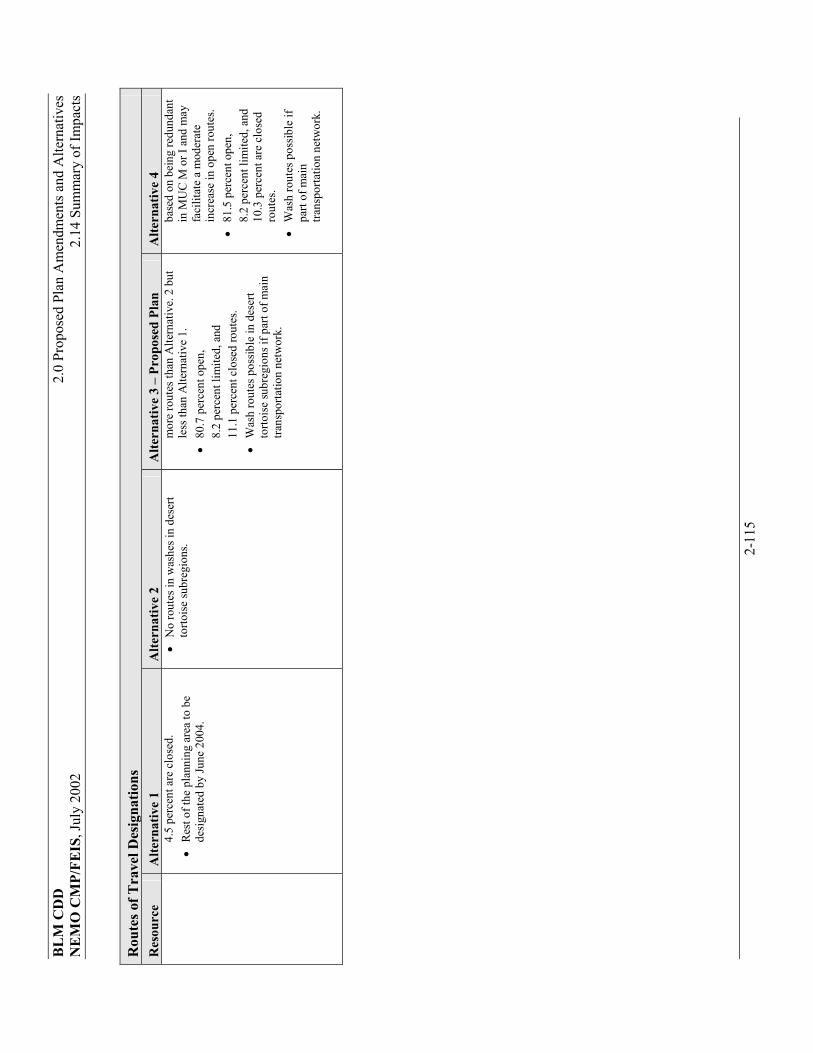
BLM
CD
D2.
0 Pr
opos
ed P
lan
Am
endm
ents
and
Alte
rnat
ives
N
EMO
CM
P/FE
IS, J
uly
2002
2.
14 S
umm
ary
of Im
pact
s
2-11
5
Rou
tes o
f Tra
vel D
esig
natio
ns
Res
ourc
e A
ltern
ativ
e 1
Alte
rnat
ive
2 A
ltern
ativ
e 3
– Pr
opos
ed P
lan
Alte
rnat
ive
4
4.5
perc
ent a
re c
lose
d.
��
Res
t of t
he p
lann
ing
area
to b
e de
sign
ated
by
June
200
4.
��
No
rout
es in
was
hes i
n de
sert
torto
ise
subr
egio
ns.
mor
e ro
utes
than
Alte
rnat
ive.
2 b
ut
less
than
Alte
rnat
ive
1.
��
80.7
per
cent
ope
n,
8.
2 pe
rcen
t lim
ited,
and
11.1
per
cent
clo
sed
rout
es.
��
Was
h ro
utes
pos
sible
in d
eser
t to
rtois
e su
breg
ions
if p
art o
f mai
n tra
nspo
rtatio
n ne
twor
k.
base
d on
bei
ng re
dund
ant
in M
UC
M o
r I a
nd m
ay
faci
litat
e a
mod
erat
e in
crea
se in
ope
n ro
utes
. ��
81.5
per
cent
ope
n,
8.
2 pe
rcen
t lim
ited,
and
10.3
per
cent
are
clo
sed
ro
utes
. ��
Was
h ro
utes
pos
sible
if
part
of m
ain
trans
porta
tion
netw
ork.
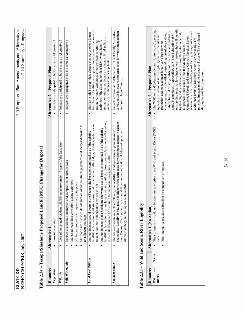
BLM
CD
D2.
0 Pr
opos
ed P
lan
Am
endm
ents
and
Alte
rnat
ives
N
EMO
CM
P/FE
IS, J
uly
2002
2.
14 S
umm
ary
of Im
pact
s
2-11
6
Tab
le 2
.34
– T
ecop
a/Sh
esho
ne P
ropo
sed
Lan
dfill
MU
C C
hang
e fo
r D
ispo
sal
Res
ourc
e A
ltern
ativ
e 1
Alte
rnat
ive
2 –
Prop
osed
Pla
n V
eget
atio
n ��
Loss
of v
eget
atio
n ��
Impa
cts a
re a
ntic
ipat
ed to
be
the
sam
e as
Alte
rnat
ive
1
Wild
life
��
Loss
of a
ssoc
iate
d re
side
nt w
ildlif
e on
app
roxi
mat
ely
5 ac
res o
f the
leas
e si
te.
��
Impa
cts a
re a
ntic
ipat
ed to
be
the
sam
e as
Alte
rnat
ive
1
Soil,
Wat
er, A
ir
��
Surfa
ce d
istu
rban
ce, d
isru
ptio
n an
d co
mpa
ctio
n of
surfa
ce so
ils
��
Incr
ease
d lo
cal d
ust g
ener
atio
n du
ring
activ
ities
. ��
No
futu
re g
roun
dwat
er im
pact
s are
ant
icip
ated
��
Shos
hone
site
also
incl
udes
dis
rupt
ion
of n
atur
al d
rain
age
patte
rns a
nd in
crea
sed
eros
ion
to
an a
djac
ent d
rain
age.
��
Impa
cts a
re a
ntic
ipat
ed to
be
the
sam
e as
Alte
rnat
ive
1
Lan
d U
se/ U
tiliti
es
��
Indi
rect
impa
cts w
ould
occ
ur a
t the
Tec
opa
site
base
d on
con
tinue
d us
e of
the
exis
ting
land
fill a
utho
rizat
ion
until
site
clo
sure
and
recl
amat
ion
is a
ffect
ed, o
r, if
stat
e st
anda
rds c
an
be m
et, u
ntil
the
auth
oriz
atio
n ex
pire
s in
2007
. ��
Indi
rect
impa
cts a
t the
Sho
shon
e sit
e w
ould
occ
ur b
ased
on
cont
inue
d us
e of
the
exis
ting
land
fill a
utho
rizat
ion
at a
muc
h re
duce
d ra
te, u
ntil
site
clos
ure
and
recl
amat
ion
is e
ffect
ed, o
r, if
stat
e st
anda
rds c
an b
e m
et, u
ntil
the
auth
oriz
atio
n ex
pire
s in
2008
.
��
Sim
ilar t
o A
lt 1
exce
pt th
at: c
losu
re m
ay o
ccur
ove
r a lo
nger
tim
e fra
me.
Fac
ilitie
s are
exp
ecte
d to
get
a li
mite
d am
ount
of
use
in th
e fu
ture
with
mod
est i
mpa
cts f
rom
land
fillin
g ac
tiviti
es.
The
Stat
e, ra
ther
than
BLM
, wou
ld id
entif
y m
itiga
tion
mea
sure
s, be
caus
e it
is a
gain
st B
LM p
olic
y to
in
clud
e en
cum
bran
ces o
n th
ese
pate
nts.
Soci
oeco
nom
ic
��
The
soci
oeco
nom
ic im
pact
s of r
etai
ning
the
land
fills
in F
eder
al o
wne
rshi
p ar
e un
know
n re
gion
ally
. Lo
cally
, it m
ay re
sult
in h
ighe
r sho
rt-te
rm c
osts
for w
aste
man
agem
ent i
n ea
ster
n In
yo C
ount
y. T
he lo
ng-te
rm c
osts
are
diff
icul
t to
pred
ict,
and
wou
ld d
epen
d up
on th
e ul
timat
e st
rate
gy a
nd ti
min
g fo
r eac
h la
ndfil
l.
��
Impa
cts a
re si
mila
r to
Alte
rnat
ive
1 ex
cept
loca
lly A
ltern
ativ
e 2
may
resu
lt in
low
er sh
ort-t
erm
cos
ts fo
r was
te m
anag
emen
t in
Eas
tern
Inyo
Cou
nty.
Tab
le 2
.35
– W
ild a
nd S
ceni
c R
iver
Elig
ibili
ty
Res
ourc
e A
ltern
ativ
e 1
(No
Act
ion)
A
ltern
ativ
e 2
– Pr
opos
ed P
lan
Wild
an
d Sc
enic
R
iver
s ��
The
six
segm
ents
wou
ld n
ot b
e de
term
ined
elig
ible
to th
e W
ild a
nd S
ceni
c R
iver
s (W
SR)
syst
em.
��
This
alte
rnat
ive
prov
ides
a b
asel
ine
for c
ompa
rison
of i
mpa
cts.
��
The
WSR
Act
and
fede
ral g
uide
lines
requ
ire fe
dera
l age
ncie
s, up
on d
eter
min
atio
n of
WSR
elig
ibili
ty, t
o pr
ovid
e in
terim
pr
otec
tion
and
man
agem
ent f
or a
rive
r’s fr
ee-f
low
ing
char
acte
r and
any
iden
tifie
d ou
tsta
ndin
g re
mar
kabl
e va
lues
, su
bjec
t to
valid
exi
sting
righ
ts, u
ntil
such
tim
e as
a su
itabi
lity
stud
y is
com
plet
ed.
App
endi
ces O
, S, a
nd T
des
crib
es th
e ou
tsta
ndin
g re
mar
kabl
e va
lues
on
each
stre
am th
at w
ill b
enef
it by
this
elig
ibili
ty d
eter
min
atio
n. D
urin
g th
is in
terim
per
iod,
al
l pro
posa
ls th
at c
ould
affe
ct th
e A
mar
gosa
Riv
er,
Cot
tonw
ood
Cre
ek, a
nd S
urpr
ise
Can
yon
Cre
ek a
nd th
eir
reso
urce
s w
ill b
e ev
alua
ted
agai
nst t
he re
gula
tory
crit
eria
and
ad
ditio
nal l
imits
on
uses
may
occ
ur.
Furth
er a
naly
sis o
f po
tent
ial i
mpa
cts t
o al
l res
ourc
es a
nd u
ses w
ill b
e ev
alua
ted
durin
g th
e su
itabi
lity
anal
ysis
.