20 Circular Walks - mediafiles.thedms.co.uk · 20 Circular Walks East Norfolk Coast ... There’s...
25
National Trail 20 Circular Walks East Norfolk Coast
Transcript of 20 Circular Walks - mediafiles.thedms.co.uk · 20 Circular Walks East Norfolk Coast ... There’s...

National Trail 20 Circular WalksEast Norfolk Coast

The walks in this guide are designed to make the most of the natural beauty and cultural heritage of the Norfolk coast. As companions to stretch one and two of the Norfolk Coast Path (part of the England Coast Path), they are a great way to delve deeper into this historically and naturally rich area. A wonderful array of landscapes and habitats await, many of which are home to rare wildlife. The architectural landscape is expansive too. Churches dominate, rarely beaten for height and grandeur among the peaceful countryside of the coastal region, but there’s much more to discover. From one mile to nine there’s a walk for everyone here, whether you’ve never walked in the countryside before or you’re a seasoned rambler. Many of these routes lend themselves well to trail running too. With the Cromer ridge providing the greatest elevation of anywhere in East Anglia, it’s a great way to get fit as you explore.The walks often pass pubs, cafés and local shops, offering a great opportunity to experience local cuisine and learn more about the area. Whatever the weather, the welcomes are always warm on the Norfolk Coast.Once you’ve tried all of these walks, why not try one of our long distance trails – the Norfolk Coast Path, Paston Way and Weavers way are all nearby. More information can be found on our website, www.norfolktrails.co.uk.
Getting aroundMost of the towns and villages where these walks begin and end are well served by public transport. Plan your car free journey using the Traveline website, www.travelineeastanglia.org.uk. Please respect the natural environment that these walks pass through. Stay on the designated paths, and take any litter home with you. Some of these routes pass through sensitive conservation areas, and some through livestock grazing areas, so
1
Introduction
please be mindful to keep dogs under control and leave gates as you find them.
EquipmentDepending on the weather, some sections of these walks can be muddy. Even in dry weather, a good pair of walking boots or shoes is essential for the longer routes. Norfolk’s climate is drier than much of the country but unfortunately we can’t guarantee sunshine, so packing a waterproof is always a good idea. If you are lucky enough to have the weather on your side, don’t forget sun cream and a hat.
Other considerationsThe walks described in these pages are well signposted on the ground, and detailed downloadable maps are available for each at www.norfolktrails.co.uk. However, best practice in the countryside is always to carry a map. All of the circular walks in this guide are covered by OS Explorer Maps 251, 252 and OL40. Many of the walks take in sections of road, and while these are quiet, they are still open to traffic, so please take care. If you plan to walk alone, remember to let someone know where you are going, when you plan to return and always carry a charged mobile phone with you. Not all of the walks pass shops or pubs so don’t forget to take plenty of refreshments too.
Help us to help youWe have lots of opportunities for volunteering on the Norfolk Trails network, so if you’d like to get involved, get in touch. If you have any questions or comments regarding any of these walks, please don’t hesitate to contact us with these too. Email: [email protected]: 0344 800 8009
2

3
Walk NumberNorfolk Coast Path National TrailNorfolk Coast Path (From October 2016)Weavers’ Way
Paston WayAngles WayWherryman’s WayMarriott’s Way Boudicca WayBure Valley PathRailwayRoad
Legend
Contents
123456789
1011121314151617181920
Walk
WeybourneSheringhamWest RuntonRoman CampFelbriggHappy ValleyOverstrandTriminghamSouthreppsTrunchMundesleyBactonWalcottHappisburghHoning LockEast RustonSea PallingWintertonMautby MarshBurgh Castle
Page
579
1113151719212325272931333537394143
Distance (miles)
56
3.596
1.58.5
23.53.5
64.54.5
73.5
66
3.571
4

Weybourne
5
Weybourne beach is popular with anglers and is a launch site for several commercial fishing vessels. If your timing’s right as you start the walk, you might see one of these small, traditional boats launching. It’s an impressive feat to behold on the steep shingle beach, the splash of the boat entering the water before its crew jumps aboard and calmly puts out to sea.Challenging for some, the first section involves crunching along the shingle beach before heading inland through grazing land and past the quag - a pond that’s home to plenty of bird life. From here the route ascends onto Kelling Heath, a site of great geological interest as one of the best examples of a glacial outwash plain in England. The heath’s dry conditions are perfect for the birder too, with nightjar, whitethroat and tree pipit all nesting on the site. From the edge of the heath’s treeline, you’ll enjoy a great view of Weybourne village, and beyond across the sea.Back in the Village, there’s ample opportunity to reward your tired legs and refuel, with a pub, cafe and tea rooms to choose from.
6
Getting startedThe walk starts at the Beach Lane car park, Weybourne (TG110436).Getting thereThe Coasthopper bus stops at All Saints Church, The Street, Weybourne. There’s also a lot of car parking at the Beach Lane car park, Weybourne (charges apply).Maps and guidesOrdnance Survey Explorer Map 251, Norfolk Coast Central. What to expectFootpaths, shingle beach and steep gradients.FacilitiesWeybourne has a shop, café, pub and a few places of accomodation. There are no public toilets on this route.
5 miles - 2 hours

7
It would be difficult to pack more landscapes into a six mile walk than you’ll encounter here. Whether it’s the undulating clifftops between Sheringham and Weybourne, the sweeping parkland, ancient oak woodland and famous rhododendrons of Sheringham Park, or the quiet marsh, fen and grassland of Beeston Common, this walk has a bit of everything. This walk is especially suited to the nature lover. Beeston Common boasts no less than nineteen species of dragonfly, and Sheringham Park has three species of deer. The varied habitats this walk passes through hold such a rich and diverse array of flora and fauna that there isn’t room here to even scratch the surface. Each of the sites mentioned above has its own website for more information. At the end of your walk, take some time to explore the characterful seaside town of Sheringham with its independent shops and museums.
Sheringham
8
Getting startedStart on The Esplanade, Sheringham, (TG156434) or at the Pretty Corner Woods car park, Pretty Corner Lane (TG153412).Getting thereThe start point in Sheringham is only a short walk from Sheringham railway station, and also close to bus stops for the Coasthopper bus and Sanders bus services 5, 17, 44A and X44 on railway approach. Parking on the Esplanade is free, as is car parking at the Pretty Corner start point.Maps and guidesOrdnance Survey Explorer Map 252, Norfolk Coast East. What to expectUndulating clifftop paths, footpaths and quiet lanes.FacilitiesThere are many shops, cafés, pubs and places of accommodation in Sheringham. Public toilets can be found on the esplanade.
6 miles - 2 hours

9
The West Runton Circular is a charming route for families, first time walkers or those who just want a quick walk. Following the base of Incleborough hill, the route is less undulating than the nearby Roman Camp walk, but shares much of the same character and charm. Following sunken pathways between hedgerows and fields, you are often treated to glimpses of the sea.On the fringes of East Runton, you’ll pass beneath two railway viaducts. One is still in use today and supports the Norwich-Sheringham line. The other, though disused, is a fine example of industrial engineering.When you’re back at the start near West Runton beach, explore the rock-pools and keep an eye out for fossils; the skeleton of the famous West Runton mammoth was found in the cliffs here so who knows what you might discover.
West Runton
10
Getting startedThe walk starts and finishes at Water Lane Car Park, West Runton (TG185431).Getting thereWest Runton is accessible by train on the Norwich-Sheringham line, and by Coast Hopper bus. The Post Office bus stop, Cromer Road, West Runton, is also visited by the Sanders 5, 44A and X44 bus services. Car parking at the Water Lane car park is available year-round, but charges apply March-October.Maps and guidesOrdnance Survey Explorer Map 252, Norfolk Coast East. What to expectClifftop paths, footpaths and quiet lanes.FacilitiesThere are public toilets (seasonal opening) and a cafe at the start of the walk. The route also passes many other pubs, Cafés and shops in both East and West Runton.
3.5 miles - 1 hour
11
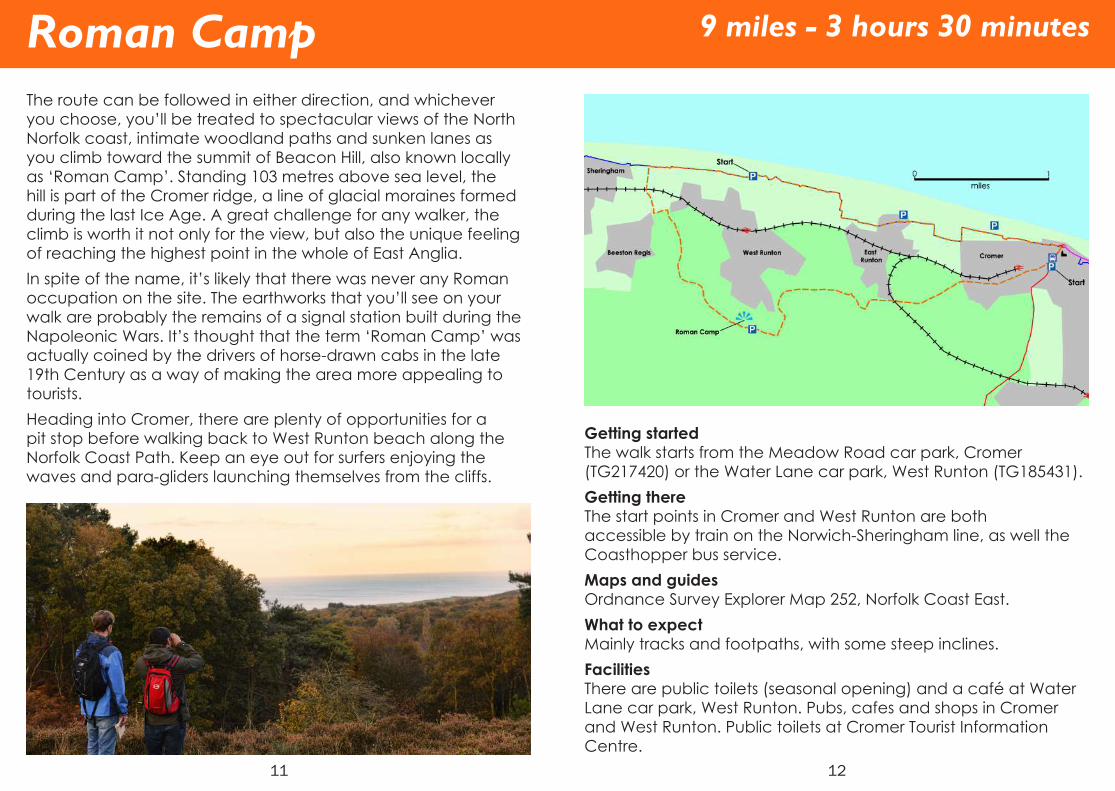
The route can be followed in either direction, and whichever you choose, you’ll be treated to spectacular views of the North Norfolk coast, intimate woodland paths and sunken lanes as you climb toward the summit of Beacon Hill, also known locally as ‘Roman Camp’. Standing 103 metres above sea level, the hill is part of the Cromer ridge, a line of glacial moraines formed during the last Ice Age. A great challenge for any walker, the climb is worth it not only for the view, but also the unique feeling of reaching the highest point in the whole of East Anglia.In spite of the name, it’s likely that there was never any Roman occupation on the site. The earthworks that you’ll see on your walk are probably the remains of a signal station built during the Napoleonic Wars. It’s thought that the term ‘Roman Camp’ was actually coined by the drivers of horse-drawn cabs in the late 19th Century as a way of making the area more appealing to tourists.Heading into Cromer, there are plenty of opportunities for a pit stop before walking back to West Runton beach along the Norfolk Coast Path. Keep an eye out for surfers enjoying the waves and para-gliders launching themselves from the cliffs.
Roman Camp
12
Getting startedThe walk starts from the Meadow Road car park, Cromer (TG217420) or the Water Lane car park, West Runton (TG185431).Getting thereThe start points in Cromer and West Runton are both accessible by train on the Norwich-Sheringham line, as well the Coasthopper bus service.Maps and guidesOrdnance Survey Explorer Map 252, Norfolk Coast East. What to expectMainly tracks and footpaths, with some steep inclines.FacilitiesThere are public toilets (seasonal opening) and a café at Water Lane car park, West Runton. Pubs, cafes and shops in Cromer and West Runton. Public toilets at Cromer Tourist Information Centre.
9 miles - 3 hours 30 minutes

13
Starting close to the sea in Cromer, this walk quickly shifts from town to country. Following the Weavers Way inland, the route soon passes Cromer Hall. Though not open to the public, its Gothic Revival architecture can be admired from the path. Then, after heading across open parkland and through the sleepy village of Felbrigg, travel back in time – at least architecturally speaking – to Jacobean Felbrigg Hall.As a National Trust property, Felbrigg Hall and most of its estate are open to the public. Parts of the estate are designated as Sites of Special Scientific interest, supporting a vast array of wildlife. At dusk, it’s not uncommon to see barn owls gliding low across Felbrigg’s parklands.Leaving the Felbrigg Estate, loop your way back to Cromer via the wooded hills of East Runton.
Felbrigg
14
Getting startedThe walk starts at the Meadow Road car park, Cromer (TG217420).Getting thereThe start point in Cromer is accessible by train on the Norwich-Sheringham line, as well as on the Coasthopper bus service.Maps and guidesOrdnance Survey Explorer Map 252, Norfolk Coast East. What to expectUndulating footpaths, tracks and quiet lanes.FacilitiesThe walk begins and ends close to the town centre, where you will find shops, cafés, pubs and restaurants. Public toilets can be found at the Cromer Tourist Information Centre, at the north end of Meadow Road car park. There’s also a café and toilets at Felbrigg Hall.
6 miles - 2 hours

15
This walk may be short but don’t worry - there’s plenty to see here. The route follows the quickly ascending clifftop path out of Cromer, soon rewarding any walker’s efforts with stunning views across the town and undulating cliffs beyond. On a clear day, offshore wind farms can be seen, as well as the many ships that ply the North Sea routes off the Norfolk Coast.After savouring the views, wander down through Warren Woods. The woods were once part of the pleasure grounds of The Warren, and many typical broadleaved tree species can be found here including beech, oak and lime. If you’re lucky enough to be visiting in spring, you’ll be welcomed by a carpet of bluebells and white ransoms.The walk can easily be extended to take in the lighthouse up close. While not open to the public, the area around the octagonal tower and keeper’s cottage is accessible. After finishing this walk there’s plenty to do in Cromer - not least a stroll on the pier, visiting one of the fascinating museums or simply enjoying an icecream on the beach.
Happy Valley
16
Getting startedThe Walk starts on the clifftop path, just east of North Lodge (TG222421).Getting thereThe start point in Cromer is accessible by train on the Norwich-Sheringham Line, as well as on the Coasthopper bus service. There’s plenty of car parking at the Meadow Road Car Park, Cromer (charges apply).Maps and guidesOrdnance Survey Explore Map 252, Norfolk Coast East. What to expectFootpaths and paved footways.FacilitiesThe walk begins and ends close to the town centre, where you will find shops, cafés, pubs and restaurants. Public toilets can be found at the nearby tourist information centre.
1.5 miles - 45 minutes

17
This is a longer walk, with a veriety of sights to see. The disused railway that runs just south of Overstrand has returned to nature since its closure in 1953, and is now a County Wildlife Site. Beyond this, heading south, can be found the best views of the rolling farmland that characterises much of the route.The walk passes two fine medieval churches, St Mary’s in Northrepps and the church of St James in Southrepps with its ornate tower, and both are worth making a stop for. Likewise, the two large 18th Century barns of Winspurs Farm (thought to have been a base for smugglers during the Napoleonic era) are strik-ing examples of the wealth of architecture on show. Keep an eye out for the Shrieking Pit, a tree-shaded pond that you will pass to the east of Northrepps, which as local legend has it, is haunted by the spectre of a girl said to have been drowned there.For a break from the route’s rich history and natural heritage, why not stop for lunch at one of the pubs that are well signposted from the route.
Overstrand
18
Getting startedThis walk starts at the Overstrand car park (TG248410).Getting thereThe Sanders 5 and 35B bus services both stop at the Post Office in Overstrand.Maps and guidesOrdnance Survey Explorer Map 252, Norfolk Coast East. What to expectMainly farm tracks and footpaths, with some crossfield paths that can be muddy following wet weather.FacilitiesPubs, cafes, shops and accommodation can be found in Overstrand, all within a half mile of the walk’s start. Southrepps and Northrepps both have pubs, signed from the route.
8.5 miles - 3 hours

19
Open almost every day, the church of St John the Baptist’s head is one of only three churches to bear this name. While the saint’s head was never on display here, it’s thought that a shrine, complete with a life-sized alabaster carving of the head was kept here. In spite of the destruction of this image during the reformation, the church is still worth a visit for its restored rood screen and more recent stained glass windows.The rest of the walk is perfect for the first time walker, with a relatively flat profile that still offers rolling views inland and well surfaced, quiet lanes to link the various paths and tracks.
Trimingham
20
Getting startedThe walk starts by the Church of St John the Baptist’s Head, Church Street, Trimingham (TG279387).Getting thereSanders bus service 5 stops at the Broadwood Close bus stops, and is the best way to reach the walk’s start.Maps and guidesOrdnance Survey Explorer Map 252, Norfolk Coast East. What to expectCrossfield footpaths, farm tracks and quiet lanes.FacilitiesTrimingham offers camping and caravan accommodation. There are no public toilets on this route. Shops, cafés and restaurants can be found in nearby Mundesley or Cromer, both also on the number 5 bus route.
2 miles - 45 minutes

21
Southrepps Common is an incredibly diverse and interesting area in Lower Southrepps, made up of several sites straddling Lower Street. With 160 plant species and a wide variety of bird species found across the Common, there’s much to look out for, including fragrant orchid, marsh helleborine, common cottongrass and bog bean. An extensive network of boardwalks allows you to enjoy the open expanse of reedbed and other wetland habitats on the eastern side and woodland on the west. Away from the common, the walk follows quiet lanes and peaceful field-edge footpaths between the northern and southern parts of Southrepps, passing Manor Farm’s 19th Century house and Barn. Though both are dated 1823, there’s evidence of older buildings having existed on the site since the medieval period.
Southrepps
22
Getting startedStarts on Pit street outside the social club carpark (TG262353).Getting thereSanders bus service 33 stops at Southrepps Primary School, and there is a limited amount of free parking at the walk’s start point on Pit Street. Gunton Lane train station is nearby.Maps and guidesOrdnance Survey Explorer Map 252, Norfolk Coast East. What to expectQuiet Lanes, tracks, boardwalk and footpaths.FacilitiesGeneral store and Vernon Arms pub in Upper Southrepps. There are no public toilets on this walk.
3.5 miles - 1 hour

23
St Botolph’s church is close to the start of the walk, and well worth a look around. Built in the 15th Century, its oak font canopy is rich with carved detail and one of only four such canopies surviving in England.The route also passes other locations of architectural interest, with many historic barns and farmhouses lining both Brewery Road and Mundesley Road. The oldest of these is the 16th Century flint and brick Hall Farm House, as well as its two barns of a similar age.The route rambles along between these on quiet lanes and wooded footpaths that are best savoured on a breezy summers day, dappled with sunlight.
Trunch
24
Getting startedThe walk starts on Front street outside the Crown Inn, Trunch (TG287348).Getting thereSanders bus services 5, 34, and 55 all stop at the Old Forge Close bus stop, Trunch.Maps and guidesOrdnance Survey Explorer Map 252, Norfolk Coast East. What to expectRural footpaths and quiet lanes.FacilitiesTrunch has a village shop, and the Crown Inn pub.
3.5 miles - 1 hour

25
This walk takes a slightly elevated route between Mundesley and Gimingham, and typically of Norfolk, this slight rise in the land is all that’s needed to enjoy stunning views across the lush countryside. As you ramble along in the lee of the Cromer ridge, count the many church towers that stand proud of the patch-work arable and grazing land and watch smoke rise from the chimneys of Gimmingham and Trunch. There are few places in Norfolk that give you the sense of being above it all, but this is definitely one. For a closer view of the local churches, Gimmingham All Saints lies just 300 yards south of the route in Gimmingham, and you’ll pass the imposing St Botolph’s in Trunch. Not far from the church in Trunch is the Crown Inn, a country pub serving traditional food.Quiet lanes lead back to Mundesley, which has plenty of hotels overlooking the sea. The Norfolk Coast Path and Paston Way both pass through. Making the village a perfect base for a walking break
Mundesley
26
Getting startedThe walk starts outside the Mundesley tourist information centre, on Station Road, Mundesley (TG311365).Getting thereThe Start point is close to bus stops on Station Road, serviced by the Sanders 5 and 34 bus services. Car parking at the Station Road car park, Mundesley, is free.Maps and guidesOrdnance Survey Explorer Map 252, Norfolk Coast East. What to expectA mixture of crossfield and field-edge footpaths and quiet lanes.FacilitiesThe walk begins and ends in the centre of Mundesley, where you will find a great set of shops selling local produce, as well as some cafés. More cafés and eateries can be found nearby, along with hotels, on Cromer Road and Beach Road. Public toilets can be found on Beach Road and Back Street.
6 miles - 2 hours

27
Though Bacton is now famous for its gargantuan gas terminal, this is a glorious countryside ramble in the truest sense. For much of the route you’ll scarcely be aware of the terminal’s presence on the cliff top to the west of the village. The route crosses verdant countryside to link St Andrew’s church (just outside the village) with the much older round tower church of St Margaret at Witton. Both are worth visiting, though while the former is open to the public, the latter can only be entered by appointment with the wardens.The route is mostly flat and open, with the land rolling gently towards the sea. The views across fields and pleasant grazing meadows are particularly enjoyable on an autumn morning, with far off leaves on the turn and mist clinging to the geography’s subtle folds.Returning to Bacton there are plenty of opportunities for refreshment, as well as the beach for picnics. To explore the area further you can easily pick up sections of Paston Way or the Nor-folk Coast Path which both run nearby.
Bacton
28
Getting startedThe Walk begins on Coast Road, Bacton, either opposite Cable Gap Holiday Park (TG341341), or at the Junction with Church Road, Bacton (TG341337).Getting thereSanders Bus service 34 stops at the shops on Coast Road, in between the alternative start points. There is free car parking on Abbey Street, and the walk’s start is signposted from there.Maps and guidesOrdnance Survey Explorer Map 252, Norfolk Coast East. What to expectFootpaths, farm tracks and quiet lanes.FacilitiesBacton has pubs, cafés and a restaurant. There are no public toilets on this route.
4.5 miles - 1 hour 30 minutes

29
Sharing part of its course with the longer Happisburgh Circular walk, this route still has much to offer. Leaving Happisburgh by the cliff top path, you’ll be walking above the site where early human footprints were found in sediment on the beach in 2013, famously the earliest found outside of Africa. Heading inland you’ll soon pass Walcott’s Church of All Saints, which is worth a visit for its bright and airy interior. Like Happisburgh’s church, Walcott’s is heavily Victorianised, with the screen being one of its few remaining medieval features. However, unlike its larger neighbour, All Saints is home to some fantastic modern features dating from the 1920s, such as an art nouveau brass lectern, and art-deco organ. The route pivots around this point. Standing proud of its flat, agricultural surrounds, the church is visible throughout the walk.
Walcott
30
Getting startedThe walk starts and finishes the Beach Road par park, Happisburgh (TG384308).Getting thereHappisburgh can be reached via Sanders 34 bus route, with stops on The Street, by the primary school. The Beach Road car park is open year round (charges apply).Maps and guidesOrdnance Survey Explorer Map 252, Norfolk Coast East. What to expectClifftop paths, footpaths and quiet lanes.FacilitiesTearooms and Hillhouse pub in Happisburgh. Lighthouse Inn at Walcott. Public toilets are located in the Beach Road car park.
4.5 miles - 1 hour 30 minutes

31
There is much to see on this walk from the pretty little village of Happisburgh. The walk begins and ends close to Happisburgh’s famous red and white lighthouse, tours of which can be organ-ised throughout the year – check the website for details. From the lantern room, the view is breath-taking. On clear days it’s possible to see the superstructures of oil rigs, far off shore.As for other high points, there’s St Mary’s church. It stands so proud on its little hillock as to make it seem much taller. Outside, in the northeast corner of the churchyard is the mass grave for the crew of HMS Invincible, which foundered offshore in 1801 on its way to join Nelson’s fleet. From one church to another, the walk meanders cross country along paths and lanes to the more modest church of St Peter in Ridlington.
Happisburgh
32
Getting startedThe walk starts and finishes the Beach Road car park, Happisburgh (TG384308).Getting thereIt can be reached via Sanders 34 bus route, with stops on The Street, Happisburgh, by the primary school. The Beach Road car park is open year round (charges apply).Maps and guidesOrdnance Survey Explore Map 252, Norfolk Coast East. What to expectClifftop paths, footpaths and quiet lanes.FacilitiesThere are tearooms and the Hillhouse pub in Happisburgh. Public toilets are located at the Beach Road car park.
7 miles - 2 hours 15 minutes

33
Before you see Honing lock, you’ll hear the water rushing down through its length, its gates removed long ago. On a summer day, this man made waterfall, the dense vegetation and wild flowers that surround it could have you thinking you’ve stepped out of Norfolk and into a jungle.The lock now represents the Dilham Canal’s head of navigation, so along with the wet woodland’s various fauna, and the cattle that graze the fields beyond, you’re likely to encounter cheery canoeists as you walk. The northern half of this walk follows the route of the former Midland and Great Northern Railway, another remnant of a more industrial past, which now forms the Weavers’ Way.
Honing Lock
34
Getting startedThe walk starts at the Weavers’ Way car park, Chapel Road, East Ruston (TG346272).Getting thereThere is free parking available at the start location.Maps and guidesOrdnance Survey Explorer Map OL40, The Broads. What to expectFootpaths and tracks, which can become waterlogged in winter.FacilitiesThe Butchers Arms is signposted from the car park.
3.5 miles - 1 hour

35
Though canals are commonplace across much of the country, the Dilham Canal is the only one in the whole of Norfolk. Wider than the standard, the canal was designed to bear wherries laden with produce to the mills. However, it was constructed at a time which soon put it in direct competition with the railways. Gradual silting up and damage caused by the great storm of 1912 hastened its decline. It now provides a haven for wildlife, especially on the wooded stretches you’ll encounter on this walk. If you’re lucky, you might spot an otter gliding about in the canal, or even a shining blue kingfisher perched high on a branch.The northern portion of the walk skirts the woodland of Hon-ing Common and passes St Peters and St Pauls church before crossing fields back to East Ruston Village.
East Ruston
36
Getting startedThe walk has two start/finish points – one at the Weavers Way car park, Chapel Road, East Ruston, and one at the Butchers Arms, East Ruston. Getting thereThere is free parking available at both start locations.Maps and guidesOrdnance Survey Explorer Map OL40, The Broads. What to expectFootpaths, tracks and quiet lanes, which can become water-logged in winterFacilitiesThe Butchers Arms pub, East Ruston. There are no public toilets on this walk.
6 miles - 1 hour 30 minutes

37
With its offshore reefs and the small bays these have created, Sea Palling is unique on the Norfolk Coast. These sheltered inlets are the perfect place for a walker to stop and stare. At certain times of the year, you might see the odd seal, or the silver flash of a low-flying flock of terns. Sea Palling beach has the potential to be a magical place.The inland portion of the walk is just as beautiful, with far reaching views across the northern Broadland region, and the lonely St Andrew’s Church, Hempstead, with its thatched roof peering through the trees as it is approached. In the late summer, the hedgerows around the church, and those that line the local bridleways are rich with blackberries and even a few plum trees.Once your walk is done, why not relax with a drink outside The Reefs Bar, or refuel with some local fish and chips.
Sea Palling
38
Getting startedThe walk starts from Beach Road, Sea Palling (TG429274).Getting thereSanders bus service 34 stops at the Sea Palling bus terminus on Clink Road, Sea Palling. Car Parking is available on Clink Road, Sea Palling (charges apply).Maps and guidesOrdnance Survey Explorer Map OL40, The Broads. What to expectQuiet Lanes (which can become busier during peak holiday season), footpaths and sandy beach.FacilitiesSea Palling offers a bar, camping and caravan accommodation, shops, cafés and of course restaurants. There are public toilets at the route’s start/finish point.
6 miles - 2 hours 30 minutes

39
Winterton Dunes is internationally significant as a site of special scientific interest, and interestingly, with its acidic plant communities, has more in common with the dune systems of the Baltic than those found elsewhere on the Norfolk coast. The dunes are also a beautiful place to walk and home to the threatened natterjack toad. You’re far more likely to hear them than see them though – the mating call of the male is very loud!Away from the dunes, the walk will take you inland, to the magical ruins of St Mary’s church. Though the church survived the reformation, it fell into disuse once the church parish of East Somerton was subsumed into that of Winterton. Today, it is quite spectacular. Set in woodland and overgrown with ivy, a great oak tree grows straight up though the now-roofless chancel.
Winterton
40
Getting startedThe walk starts and finishes the Beach Road car park, Winterton (TG498197).Getting thereWinterton is served by First’s number 1 bus service. The Beach Road car park is open year round from dawn until dusk. Charges apply from April-October, and donations are welcome outside of this time.Maps and guidesOrdnance Survey Explorer Map 252, Norfolk Coast East. What to expectClifftop paths, footpaths and quiet lanes.FacilitiesWinterton has a cafe, village shop, chip shop and pub. There are public toilets at the Beach Road car park (seasonal opening).
3.5 miles - 1 hour
41
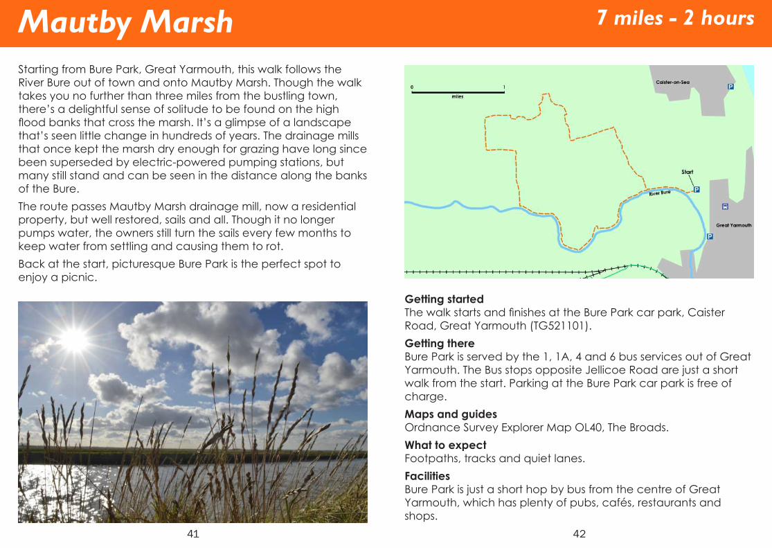
Starting from Bure Park, Great Yarmouth, this walk follows the River Bure out of town and onto Mautby Marsh. Though the walk takes you no further than three miles from the bustling town, there’s a delightful sense of solitude to be found on the high flood banks that cross the marsh. It’s a glimpse of a landscape that’s seen little change in hundreds of years. The drainage mills that once kept the marsh dry enough for grazing have long since been superseded by electric-powered pumping stations, but many still stand and can be seen in the distance along the banks of the Bure.The route passes Mautby Marsh drainage mill, now a residential property, but well restored, sails and all. Though it no longer pumps water, the owners still turn the sails every few months to keep water from settling and causing them to rot.Back at the start, picturesque Bure Park is the perfect spot to enjoy a picnic.
Mautby Marsh
42
Getting startedThe walk starts and finishes at the Bure Park car park, Caister Road, Great Yarmouth (TG521101).Getting thereBure Park is served by the 1, 1A, 4 and 6 bus services out of Great Yarmouth. The Bus stops opposite Jellicoe Road are just a short walk from the start. Parking at the Bure Park car park is free of charge.Maps and guidesOrdnance Survey Explorer Map OL40, The Broads. What to expectFootpaths, tracks and quiet lanes.FacilitiesBure Park is just a short hop by bus from the centre of Great Yarmouth, which has plenty of pubs, cafés, restaurants and shops.
7 miles - 2 hours

43
Burgh Castle is one of the best preserved Roman sites in the country. Built in the late 3rd Century AD, the fort’s thick walls are still an impressive sight. Originally, the fort would have guarded what the Romans referred to as the ‘Saxon Shore’. Though the Roman Empire crumbled, the walls remained to house Saxons and later, Norman lords who redeveloped the fort into a motte and bailey castle. There’s no doubt that the site is rich with history, but on a simpler note, it’s a beautiful place to wander, with panoramic views across Breydon water, the Marshes beyond, and the Rivers Waveney and Yare.This short walk is perfect for an afternoon out and offers good access for all. The stunning area can easily be explored further, with Angles Way passing Burgh Castle on its way out of Great Yarmouth, alongside Breydon Water and the River Waveney.
Burgh Castle
44
Getting startedThe walk begins from The English Heritage Carpark, Butt Lane, Burgh Castle (TG478049).Getting thereFirst Bus 5 or 7 from Great Yarmouth, followed by a short walk from the Kings Head bus stop, Belton. Alternatively, the 6b from Bradwell can be taken to the Queen’s Head Pub, High Road, Burgh Castle. Car parking at Burgh Castle is free. For a longer walk, Burgh Castle lies 5 miles along the Angles Way from Great Yarmouth.Maps and guidesOrdnance Survey Explorer Map OL40, The Broads. What to expectFootpaths and boardwalk.FacilitiesThe Queens Head pub in Burgh Castle. Nearby Bradwell and Belton both have shops. There are no public toilets on this route.
1 mile - 25 minutes

Circular Walks Legend
Bus StopCar ParkChurchCastleTrain StationViewpoint
45
Angles WayNorfolk Coast PathPaston WayWeavers’ WayCircular Walk Route
The maps in this guide are intended only as an overview, and are not suitable for navigation. We reccomend that trail users use the appropriate Ordnance Survey map as well as downloading a detailed route map from our website, www.norfolktrails.co.uk.
Legend
46
Norfolk Trails NetworkThe Norfolk Trails network is made up of over 1200 miles of long distance trails and circular walks. Discover a diverse landscape of unique market towns, rich wildlife and fascinating heritage.
Details correct at the time of going to print. Please be aware that routes are shared with other users (vehicles, pedestrians, horse riders etc.). Users of these routes do so at their own risk. We do not accept any responsibility for loss, damage or injury, however caused, arising directly or indirectly from this leaflet. © Crown copyright and database rights 2016 Ordnance Survey 100019340.

Written by Jack DavidsonDesigned by Chris Brough