2.0 Analysing the Context B. Adjoining Land - Main … … · 26 Shackleford • Mushroom Farm Site...
10
26 Shackleford • Mushroom Farm Site • Design and Access Statement Views of the buildings from within 1 kilometre of the Mushroom Farm are also restricted by a combination of landform, vegetation and buildings. Nevertheless, partial views of the chimneys and roof scape can be obtained from Cyder House Field and the southern end of The Street and along the site entrance off Shackleford Road. In addition, buildings on the site can be glimpsed from sections of Grenville Road and the white polytunnels can be glimpsed from Peper Harow Road and the Cricket Ground between the top of the bund and the understorey of the leylandii. Visual Impact The visual impact of the site on its surroundings has been thoroughly assessed and is set out in the Landscape and Visual Appraisal Report, (Document 10), accompanying the application. In summary, the site is not visible in most medium to long distance views from over 1 kilometre and where it is visible, its impact is limited by distance and the intervening landscape. 2.0 Analysing the Context B. Adjoining Land View of Existing Access on Peper Harow Lane Panoramic View Across Cricket Ground Looking Towards the Site
Transcript of 2.0 Analysing the Context B. Adjoining Land - Main … … · 26 Shackleford • Mushroom Farm Site...
26 Shackleford • Mushroom Farm Site • Design and Access Statement
Views of the buildings from within 1 kilometre of the Mushroom Farm are also restricted by a combination of landform, vegetation and buildings. Nevertheless, partial views of the chimneys and roof scape can be obtained from Cyder House Field and the southern end of The Street and along the site entrance off Shackleford Road. In addition, buildings on the site can be glimpsed from sections of Grenville Road and the white polytunnels can be glimpsed from Peper Harow Road and the Cricket Ground between the top of the bund and the understorey of the leylandii.
Visual Impact
The visual impact of the site on its surroundings has been thoroughly assessed and is set out in the Landscape and Visual Appraisal Report, (Document 10), accompanying the application. In summary, the site is not visible in most medium to long distance views from over 1 kilometre and where it is visible, its impact is limited by distance and the intervening landscape.
2.0 Analysing the ContextB. Adjoining Land
View of Existing Access on Peper Harow Lane
Panoramic View Across Cricket Ground Looking Towards the Site
Shackleford • Mushroom Farm Site • Design and Access Statement 27
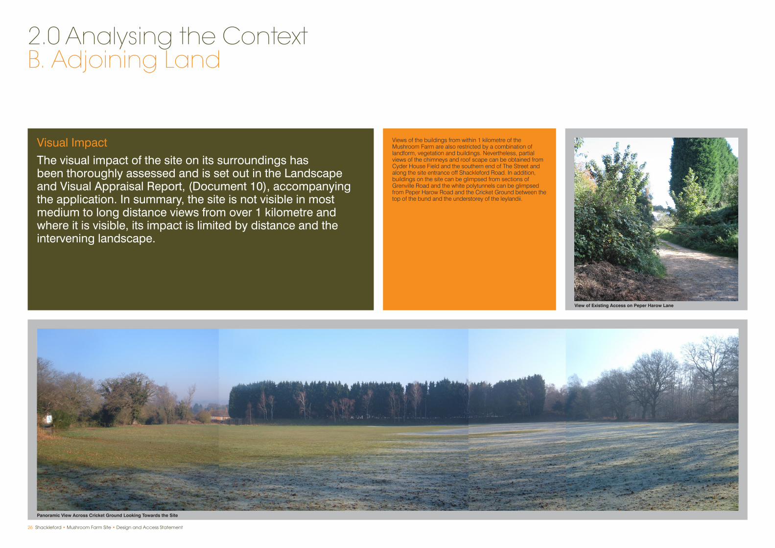
View of Existing Access on Shackleford Road
View of Site Across Cyder House Field From Footpath Near Play Area

28 Shackleford • Mushroom Farm Site • Design and Access Statement
For the purpose of analysis, the land along the application site can be divided into two categories:
i) Land owned by Wates Developments, which comprises Cyder House Field and the Cricket Ground.
ii) Land in separate ownership, which includes Norney Garage, Shackleford Heath, Glebe Farm, Burwood House, Fiddlers Hall, Shackleford Cottage and Chalcotts.
The fact that Wates Developments control areas of land outside the application site provides an opportunity for the future of the land to be secured by the planning application as part of a comprehensive approach to development and future management. However, it is of equal importance that the interests of adjacent landowners are fully considered as part of the design process and are reflected in the eventual scheme.
2.0 Analysing the ContextB. Adjoining Land
1
2 34
5
7
8
9
Application Site
Other Land (Owned by Wates Developments)
6

Shackleford • Mushroom Farm Site • Design and Access Statement 29
1. Cyder House Field
The field is an area of approximately 2.70 hectares, situated to the north of the application site, between the Mushroom Farm and the main part of Shackleford village. It is roughly triangular in shape, bounded to the west by properties fronting Peper Harow Lane and to the north and east by Grenville Road and Shackleford Road. At its northern end, adjoining the Cyder House Public House, part of the field has been separated off by a post and rail fence to form a playground which is situated on land owned by Wates Developments Limited and comprises wooden play equipment and is used by the local community and patrons of the Public House. This is separated from a small car park serving the village by an informal footpath / bridleway which follows the edge of Cyder House Field, linking Peper Harow Lane and Grenville Road.
Cyder House Field comprises agricultural land which is used as pasture by the tenant farmer. The open character of the field pertorms an important function in maintaining the character and setting of the southern part of the village and separating it from the application site and the area of low density housing lying to the south east, extending to Norney.
2. The Cricket Ground
The Cricket Ground forms the south eastern boundary of the application site. Its southern boundary is formed by Shackleford Heath and its westnern boundary by Peper Harow Lane. It has a site area of 1.51 hectares.
The ground comprises the cricket field, which is a grassed area sloping gently towards the application site and a small pavilion constructed out of a former mobile classroom, which is in a rundown condition. The Cricket Ground is open to view from Peper Harow Lane, but is otherwise well screened by the woodland of Shackleford Heath and by the artificial bund and Leylandii introduced by the Mushroom Farm to screen its activities from view.
The Cricket Ground is an important local facility and a focus for community activity. It is also used by Shackleford Cricket Club under an informal agreement with Wates Developments. It is important to the open setting and identity of Shackleford village and in views on the approach to the village from the south. Part of the ground lies within the Shackleford Conservation Area.
Access to Shackleford Heath cannot currently be achieved via the Cricket Ground.
3. Norney Grange
This is a large, privately owned house set in substantial and well wooded grounds abutting part of the application site to the south which also contains a number of smaller houses and lodges. The houses are located well away from the application site and, due to extensive tree cover, are not visible from the site.
4. Shackleford Heath
Lying to the south of the application site and the Cricket Ground, the Heath is an area of common land which is managed by Waverley Borough Council and is used for informal recreation by the local community and visitors from further afield. The Heath comprises oak dominated deciduous woodland and is traversed by a network of informal footpaths and a public bridleway. However, access cannot presently be gained from the application site and Cricket Ground to the north. There is a significant level change between the Heath and the application site marked by a retaining wall. The Heath is served by a public car park off Elstead Road.
5. Glebe Farm
This is a large, detached, brick built farmhouse fronting Peper Harow Lane. The substantial curtilage to the side and rear of the house forms a boundary with the application site which is marked on the Mushroom Farm sited by a retaining wall and a substantial drop in levels, together with extensive tree and hedgerow planting, including a belt of mature Leylandii. A tall concrete and wooden fence runs alongside the access to the Mushroom Farm site.
As a result, the buildings occupying the application site are largely obscured from Glebe House, although the taller flues are visible and glimpses of buildings can be had.
6. Burwood House
This is a substantial, modern house of classical proportions which is set well back from Shackleford Road and shares part of the application site’s eastern boundary. Burwood House is in an elevated position above the application site, and there is planting along the boundary and an earth bund and planting within the application site to restrict views of the site from the house. The house is located on rising ground above Cyder House Field and Shackleford to the north and so is dominant in views from the village.
7. Fiddlers Hall
A wide fronted, detached house with thatched roof fronting Shackleford Road and, therefore, some distance from the application site. The Hall is not visible from the application site due to significant changes in level and extensive planting within the garden, the application site and the grounds of Burwood House, which separates the two.
8. Shackleford Cottage
A modern, brick built house with multiple dormas set in a semi hipped tiled roof. The property is elevated well above the main part of the application site, but it shares its southern boundary with the main access into the site off Shackleford Road and buildings on the main part of the Mushroom Farm site are visible from its rear garden.
9. Chalcotts
This is a modest, single storey cottage fronting Shackleford Road, with a narrow and elongated garden formed between Norney Grange and the main access into the Mushroom Farm site. Buildings on the Mushroom Farm site are clearly visible from its garden.
Images: 1-9
1
4
7
2
5
8
3
6
9

30 Shackleford • Mushroom Farm Site • Design and Access Statement
Landscape Character
The Mushroom Farm is located in the foothills of the North Downs within the Surrey Hills Area of Outstanding National Beauty (AONB), which is also an Area of Great Landscape Value (AGLV).
2.0 Analysing the ContextC. Wider Context
The Surrey Hills are one of the most wooded of the nationally protected areas in the country, but are nonetheless a diverse landscape, characterised by hills and valleys, traditional mixed farming, a patchwork of chalk grassland and heathland, sunken lanes, picturesque villages and market towns. It has associations with many of the country’s great artists, writers, musicians and designers. It is often regarded as the first real countryside south of London and is a rural retreat for many thousands of daily commuters.
Around Shackleford, the gently sloping foothills which rise to the undulating plateau in the north create large areas of open rolling farmed landscape of distinct identity, known as the Greensand Hills. This area is characterised as follows:
A diverse landscape, predominantly pastoral •with arable farmland, woodland, heathland, golf courses, parkland, nurseries and paddocks.
Medium to large regular fields with straight •boundaries typical of parliamentary enclosure bounded by hedgerows with hedgerow trees or by fences.
Presence of ponds and streams including a •tributary of the River Wey which runs south through the area to Shackleford through a small scale valley bounded by narrow woodland belts.
Small areas of Open Access land on heathland •commons plus footpaths including the North Downs Way, which provide recreational access.
A network of rural roads and lanes spreads •across the area and the major route of the A3 creating a physical barrier.
Sparsely settled with historic villages of •Seale, Puttenham, Compton, Shackleford, and Peper Harow, traditional farmsteads plus some modern settlement spreading along roads at Sandy Cross and Hurtmore.
Presence of historic houses such as Puttenham •Priory, Eastbury Manor and Brabeouf Manor plus parks and gardens.
A rural, peaceful area with views across the valley •pastures to wooded hills to the south.
The landscape in the vicinity of the site shares many of the above positive characteristics. To the south of the Site lies Shackleford Heath, a mature mixed woodland predominantly containing Oak, with a native shrubby under-storey. The grazed pasture of the Cyder House Field directly to the north of the site is characteristic of the enclosed farmland of the area, whilst Peper Harrow Lane and Shackleford Road, to the west and east respectively are typical rural lanes.
However in other respects, the industrial character of the Farm and the artificially altered levels of the site are incongruous to the rural landscape setting. Furthermore, the use of planted screens and buffers, often with exotic coniferous species, which were built by the previous landowners seeking to screen the industrial sheds and poly-tunnels of the Mushroom Farm, are alien to the locality. This particularly applies to the boundary with the Cricket Ground, the Leylandii planted along the existing ditch and also to a degree to the scrubby boundary mounding between the Farm car park and Burwood House.
For further information on landscape character, please refer to the Landscape Appraisal report.(Document 10)
SHACKLEFORD
Designated Landscape Areas

Shackleford • Mushroom Farm Site • Design and Access Statement 31
Intimate Small Scale (With Short / Glimpsed Views)
Intermediate / Mixed Scale (With Medium Distance Views)
Open / Large Scale (With Long Distance Views)
Agriculture (Arable / Pastoral)
Woodland (Including Former Heathland)
Village Settlement Clusters (Close Knit)
19th / 20th Century Housing and Farmstead (Loose Knit)
Parkland
Recreational
Landscape Topography and Scale Landscape Character

32 Shackleford • Mushroom Farm Site • Design and Access Statement
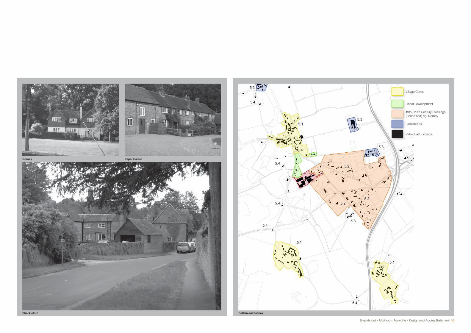
Settlement Pattern and Built Heritage
The settlement pattern and built heritage of the local area is typical of the Surrey Hills AONB, an area of predominantly open countryside featuring scattered farmsteads, historic villages and hamlets, grand houses set in parkland and extensive areas of more modern development.
Within the overall framework, the local settlement pattern comprises the following:
2.0 Analysing the ContextC. Wider Context
Shackleford
This is a small historic village which originated in the 14th Century. It lies immediately north of the application site and is formed within a shallow, dry valley running north to south through gently undulating countryside. Development is centred around The Street at the convergence of local roads. It then extends along these roads to form a linear settlement running north to south which is physically contained by farmland and the grounds of Aldro School. The village has a close knit urban grain and is both informally laid out and picturesque in appearance, comprising a range of individual buildings of domestic scale and appearance in local vernacular style. With the exception of Aldro School, all of the buildings within the village are two storeys in height or less.
The village is described by Nairn and Pevsner in ‘The Buildings of England : Surrey” in the following way:
“in an unspoilt sandstone county west of Godalming. One Street of already picturesque sandstone and brick houses, given a perceived overlay of careful early C20 planting and walling, especially at the north end, so that the whole village spreads like a serial unfolding of a good Lutyens house. There is nothing quite like this anywhere in the country. It is not least affected, and probably not done deliberately at all - the reverse of a model village.”
Between the centre of the village and the application site, development extends along the eastern frontage of Peper Harow Lane, culminating at Glebe Farm, a large, detached house in spacious grounds immediately adjoining the application site. The character of the village here is more open and is strongly influenced by the surrounding countryside. However, this linear development is an integral part of the physical fabric and character of the village, and has remained largely unaltered since the 18th Century. For this reason, further linear development along Peper Harow Lane is considered to be inappropriate.
The southern part of the village is bounded by the land owned by Wates Developments, namely the Mushroom Farm, Cyder House Field and the Cricket Ground, which contribute towards its setting and separate identity. Therefore, the future of the land is of considerable importance to the character and appearance of the village.
Shackleford is overwhelmingly residential in character. Almost all buildings are used as houses and are domestic in scale. In 2001, it had a population of 744 persons in 255 households, (parish figures).
The main exceptions to this are the Mushroom Farm and Aldro School, which is based upon the original Hall Place, but is much altered and expanded.
The character and appearance of the village is reflected by its designation as a conservation area, which extends beyond the built envelope of the village to include Aldro School and parts of its grounds, together with the northern parts of Cyder House Field and the Cricket Ground. This is to protect the setting of the village and to control further development.
Norney
To the south east of Shackleford, extending south east from the application site, is a widespread area of dispersed, low density housing which is entirely different to Shackleford village in character and appearance. The large houses in extensive grounds date from the Victorian and Edwardian periods and exhibit a range of architectural styles. Some more modern houses are suburban in character. This sparsely developed area of housing is set in dense woodland, so few of the houses are visible from public vantage points. The area extends northwards to include the properties situated between the application site and Shackleford Road and is, therefore, only separated from Shackleford village by the Mushroom Farm and Cyder House Field. The Guildford Landscape Character Assessment advises that in order to maintain the distinct identity and setting of Shackleford village, further development along the roads linking Shackleford to Norney should be avoided.
Peper Harow
This small hamlet lies within the grounds of Peper Harow Park. It has medieval origins, but has evolved as a self-contained estate community to serve Peper Harow Park, (Grade I listed), its grounds and the estate farm. It includes a chapel, stables, maintenance buildings, a Cricket Ground and more recently, converted business units. The settlement exhibits a nucleated form, in contrast with the traditional linear villages characteristic of the area. The hamlet, Peper Harow House and its immediate setting are within the Peper Harow Conservation Area.
Houses, Villas and Lodges
A number of larger houses, villas and converted estate lodges are scattered throughout the area which exhibit a wide range of architectural styles.
Farmsteads
These are sparsely scattered throughout the area.
Shackleford • Mushroom Farm Site • Design and Access Statement 33
Linear Development
Village Cores
19th / 20th Century Dwellings (Loose Knit) eg. Norney
Farmsteads
Individual Buildings
Settlement Pattern
Norney Peper Harow
Shackleford
34 Shackleford • Mushroom Farm Site • Design and Access Statement
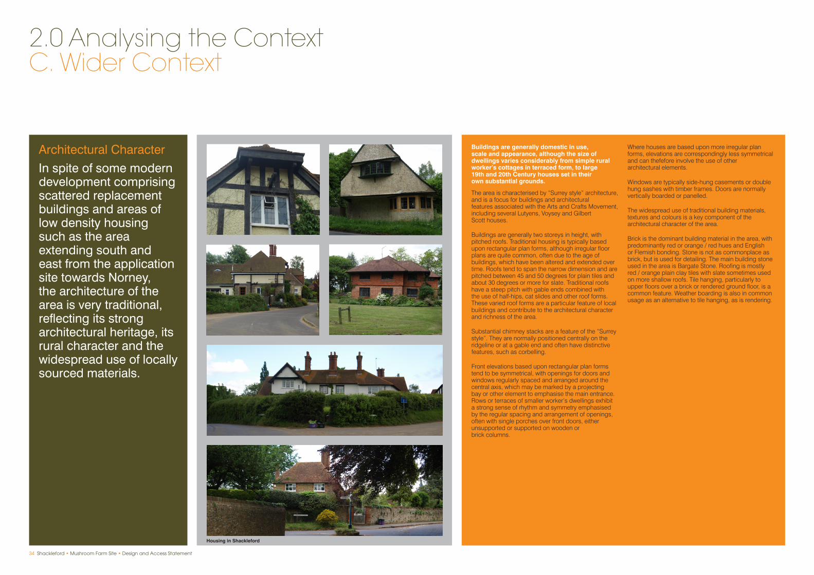
Buildings are generally domestic in use, scale and appearance, although the size of dwellings varies considerably from simple rural worker’s cottages in terraced form, to large 19th and 20th Century houses set in their own substantial grounds.
The area is characterised by “Surrey style” architecture, and is a focus for buildings and architectural features associated with the Arts and Crafts Movement, including several Lutyens, Voysey and Gilbert Scott houses.
Buildings are generally two storeys in height, with pitched roofs. Traditional housing is typically based upon rectangular plan forms, although irregular floor plans are quite common, often due to the age of buildings, which have been altered and extended over time. Roofs tend to span the narrow dimension and are pitched between 45 and 50 degrees for plain tiles and about 30 degrees or more for slate. Traditional roofs have a steep pitch with gable ends combined with the use of half-hips, cat slides and other roof forms. These varied roof forms are a particular feature of local buildings and contribute to the architectural character and richness of the area.
Substantial chimney stacks are a feature of the “Surrey style”. They are normally positioned centrally on the ridgeline or at a gable end and often have distinctive features, such as corbelling.
Front elevations based upon rectangular plan forms tend to be symmetrical, with openings for doors and windows regularly spaced and arranged around the central axis, which may be marked by a projecting bay or other element to emphasise the main entrance. Rows or terraces of smaller worker’s dwellings exhibit a strong sense of rhythm and symmetry emphasised by the regular spacing and arrangement of openings, often with single porches over front doors, either unsupported or supported on wooden or brick columns.
Where houses are based upon more irregular plan forms, elevations are correspondingly less symmetrical and can thefefore involve the use of other architectural elements.
Windows are typically side-hung casements or double hung sashes with timber frames. Doors are normally vertically boarded or panelled.
The widespread use of traditional building materials, textures and colours is a key component of the architectural character of the area.
Brick is the dominant building material in the area, with predominantly red or orange / red hues and English or Flemish bonding. Stone is not as commonplace as brick, but is used for detailing. The main building stone used in the area is Bargate Stone. Roofing is mostly red / orange plain clay tiles with slate sometimes used on more shallow roofs. Tile hanging, particularly to upper floors over a brick or rendered ground floor, is a common feature. Weather boarding is also in common usage as an alternative to tile hanging, as is rendering.
Architectural Character
In spite of some modern development comprising scattered replacement buildings and areas of low density housing such as the area extending south and east from the application site towards Norney, the architecture of the area is very traditional, reflecting its strong architectural heritage, its rural character and the widespread use of locally sourced materials.
2.0 Analysing the ContextC. Wider Context
Housing in Shackleford

Shackleford • Mushroom Farm Site • Design and Access Statement 35
Housing in Shackleford Picture of Terrace