(1999) 11, 75–92 Partitioning of intermontane basins … Tien Shan of Kyrgyzstan are bounded by...
18
Basin Research (1999) 11, 75–92 Partitioning of intermontane basins by thrust-related folding, Tien Shan, Kyrgyzstan D. W. Burbank,* J. K. McLean, M. Bullen,* K. Y. Abdrakhmatov‡ and M. M. Miller *Department of Geosciences, Pennsylvania State University, University Park, PA 16802, USA Department of Geology, Central Washington University, Ellensburg, WA 98926, USA ‡Institute of Seismology, Bishkek, Kyrgyzstan ABSTRACT Well-preserved, actively deforming folds in the Tien Shan of Kyrgyzstan provide a natural laboratory for the study of the evolution of thrust-related folds. The uplifted limbs of these folds comprise weakly indurated Cenozoic strata that mantle well-lithified Palaeozoic bedrock. Their contact is a regionally extensive unconformity that provides a persistent and readily traceable marker horizon. Based on the deformation of this marker, preserved fold geometries support simple geometric models for along-strike gradients in fold amplitude and displacement along the underlying faults, linkage among multiple structures, transfer of displacement among folds and evolution of the folds as geomorphic entities. Subsequent to initial uplift and warping of the unconformity surface, steeply dipping reverse faults cut the forelimbs of many of these folds. Wind gaps, water gaps, recent faulting and progressive stripping of the more readily eroded Cenozoic strata indicate the ongoing lateral propagation and vertical growth of fault-related folds. The defeat of formerly antecedent rivers coincides in several places with marked increases in erosional resistance where their incising channels first encountered Palaeozoic bedrock. Persistent dip angles on the backlimbs of folds indicate strikingly uniform geometries of the underlying faults as they propagate both laterally and vertically through the crust. Deformation switches irregularly forward and backward in both time and space among multiple active faults and folds with no systematic pattern to the migration of deformation. This distributed deformation appears characteristic of the entire Kyrgyz Tien Shan. shortening rates of #13 mm yr-1 within the Kyrgyz INTRODUCTION Tien Shan (Abdrakhmatov et al., 1996) and suggest that, when the shortening along the northern margin of the Intracontinental mountain building in convergent settings usually occurs as a result of the nucleation and growth Tarim Basin is included, the total shortening is likely to be #20 mm yr-1 (Michel et al., 1997): an amount equal of thrust faults. As thrust belts emerge as topographic entities, they define intermontane basins in which the to #40% of the modern Indo-Asian convergence rate. In western Kyrgyzstan, the Tien Shan comprises five detritus eroded from the bounding ranges accumulates. As convergence continues, at least three patterns of thrust-bounded ranges which are aligned approximately east–west and are separated from each other by intermon- deformation can accommodate the ongoing shortening: the early formed thrusts can continue to move and tane basins typically 15–50 km wide (Chediya, 1986; Ghose et al., 1996) (Fig. 1). Whereas shortening is accumulate more and more displacement; the zone of deformation can widen as new thrusts emerge along the presently occurring along existing range-bounding thrusts and the overall zone of deformation appears to be widen- flanks of the mountain belt; or new thrusts can develop within and between the existing mountains during ing to the north (the first two options above), it is clear that the present intermontane basins are also being densification of the thrust system. In this last scenario, the new thrusts will often encroach upon or subdivide partitioned by the development of new thrust faults. In the southern Naryn Basin and directly to the south the pre-existing intermontane basins. The Tien Shan of Kyrgyzstan represent a zone of of the Naryn River, an array of thrusts and fault-related folds have emerged which define the current basin margin intracontinental convergence in which shortening occurs in response to the ongoing convergence between India (Fig. 2) and which separate the Naryn Basin from the At Bashi basin to the south (Omuraliev & Korzhenkov, and Siberia. Recent geodetic studies indicate present © 1999 Blackwell Science Ltd 75
Transcript of (1999) 11, 75–92 Partitioning of intermontane basins … Tien Shan of Kyrgyzstan are bounded by...

Basin Research (1999) 11, 75–92
Partitioning of intermontane basins by thrust-relatedfolding, Tien Shan, KyrgyzstanD. W. Burbank,* J. K. McLean,† M. Bullen,* K. Y. Abdrakhmatov‡ and M. M. Miller†*Department of Geosciences, Pennsylvania State University,University Park, PA 16802, USA†Department of Geology, Central Washington University,Ellensburg, WA 98926, USA‡Institute of Seismology, Bishkek, Kyrgyzstan
ABSTRACT
Well-preserved, actively deforming folds in the Tien Shan of Kyrgyzstan provide a naturallaboratory for the study of the evolution of thrust-related folds. The uplifted limbs of thesefolds comprise weakly indurated Cenozoic strata that mantle well-lithified Palaeozoic bedrock.Their contact is a regionally extensive unconformity that provides a persistent and readilytraceable marker horizon. Based on the deformation of this marker, preserved fold geometriessupport simple geometric models for along-strike gradients in fold amplitude and displacementalong the underlying faults, linkage among multiple structures, transfer of displacement amongfolds and evolution of the folds as geomorphic entities. Subsequent to initial uplift andwarping of the unconformity surface, steeply dipping reverse faults cut the forelimbs of manyof these folds. Wind gaps, water gaps, recent faulting and progressive stripping of the morereadily eroded Cenozoic strata indicate the ongoing lateral propagation and vertical growth offault-related folds. The defeat of formerly antecedent rivers coincides in several places withmarked increases in erosional resistance where their incising channels first encounteredPalaeozoic bedrock. Persistent dip angles on the backlimbs of folds indicate strikingly uniformgeometries of the underlying faults as they propagate both laterally and vertically through thecrust. Deformation switches irregularly forward and backward in both time and space amongmultiple active faults and folds with no systematic pattern to the migration of deformation.This distributed deformation appears characteristic of the entire Kyrgyz Tien Shan.
shortening rates of #13 mm yr−1 within the KyrgyzINTRODUCTIONTien Shan (Abdrakhmatov et al., 1996) and suggest that,when the shortening along the northern margin of theIntracontinental mountain building in convergent settings
usually occurs as a result of the nucleation and growth Tarim Basin is included, the total shortening is likely tobe #20 mm yr−1 (Michel et al., 1997): an amount equalof thrust faults. As thrust belts emerge as topographic
entities, they define intermontane basins in which the to #40% of the modern Indo-Asian convergence rate.In western Kyrgyzstan, the Tien Shan comprises fivedetritus eroded from the bounding ranges accumulates.
As convergence continues, at least three patterns of thrust-bounded ranges which are aligned approximatelyeast–west and are separated from each other by intermon-deformation can accommodate the ongoing shortening:
the early formed thrusts can continue to move and tane basins typically 15–50 km wide (Chediya, 1986;Ghose et al., 1996) (Fig. 1). Whereas shortening isaccumulate more and more displacement; the zone of
deformation can widen as new thrusts emerge along the presently occurring along existing range-bounding thrustsand the overall zone of deformation appears to be widen-flanks of the mountain belt; or new thrusts can develop
within and between the existing mountains during ing to the north (the first two options above), it isclear that the present intermontane basins are also beingdensification of the thrust system. In this last scenario,
the new thrusts will often encroach upon or subdivide partitioned by the development of new thrust faults.In the southern Naryn Basin and directly to the souththe pre-existing intermontane basins.
The Tien Shan of Kyrgyzstan represent a zone of of the Naryn River, an array of thrusts and fault-relatedfolds have emerged which define the current basin marginintracontinental convergence in which shortening occurs
in response to the ongoing convergence between India (Fig. 2) and which separate the Naryn Basin from theAt Bashi basin to the south (Omuraliev & Korzhenkov,and Siberia. Recent geodetic studies indicate present
© 1999 Blackwell Science Ltd 75

D. W. Burbank et al.
Fig. 1. Schematic map of the major ranges and basins of the Tien Shan in the Kyrgyz Republic. Study area encompasses theranges which define the present-day southern margin of the Naryn Basin and northern margin of the At Bashi Basin. Modifiedafter Geological map of Kirghiz SSR (1980).
1995). These structures range from nascent folds to southern Naryn Basin comprise Palaeozoic miogeoclinalstrongly emergent bedrock folds which are cut by steeply strata, primarily Carboniferous carbonate and siliciclasticdipping reverse faults and which exhibit as much as 7 km strata. Following Palaeozoic and early to mid Mesozoicof structural relief. The resultant ranges provide an deformation, the bedrock throughout the study area wasexcellent opportunity to examine the growth of fault- largely bevelled by erosion prior to the onset of extensiverelated folds, displacement transfer between multiple Cenozoic deposition (Makarov, 1977; Sadybakasov, 1990).structures, spatial and temporal displacement variations, The profound, commonly angular, unconformityand the geomorphic response to rock uplift within these across the pre-Cenozoic rocks provides a remarkableactive folds and thrusts. In this paper, we present simple structural marker that can be used to define the magni-models which relate the growth of individual and mul- tude of folding and rock uplift within many parts of thetiple structures with geomorphic processes. Based on Tien Shan (Chediya, 1986; Omuraliev & Korzhenkov,reconnaissance mapping, field observations, and 1995). During the early Cenozoic in the study area, theinterpretation of satellite images and aerial photography, tilt and topographic relief on this unconformity appearwe examine the ranges bounding the southern Naryn to have been minimal. Prominently bedded CenozoicBasin in the context of the models. Finally, we discuss strata overlying the Palaeozoic bedrock can be tracedwhat the structures and geomorphology suggest in terms extensively along the flanks of folds in the study area.of the sequence of deformation and the way in which the Because the stratigraphic height of nearly any traceableupper crust responds to continued contractional
Cenozoic bed above the unconformity varies by less thanstresses.
a few metres across the several kilometres of theseexposures, it is clear that the unconformity can be
BACKGROUND GEOLOGY OF THE considered to be a nearly horizontal datum at the timeTIEN SHAN of initial Cenozoic deposition. Thus, subsequent tilting,
uplift, folding and faulting of this surface provide keyThe Tien Shan of Kyrgyzstan are bounded by the Tarimcontrols on the magnitude of Cenozoic deformation.Basin to the south and the relatively stable Kazakh
Palaeontological studies indicate that Cenozoic strataplatform to the north. Comprising primarily Palaeozoicin the Naryn and At Bashi basins span from Oligocenerocks and lesser amounts of lower Mesozoic stratato Quaternary times (Turbin et al., 1972). These strata(USSR, ANKSaMoG, 1980), the Tien Shan were de-are nonmarine and comprise facies associations inter-formed by two Palaeozoic orogenies (Burtman, 1975).preted to represent alluvial fan, fluvial, floodplain andThe approximately east–west-trending ‘Nikolai Line’ inshallow lacustrine depositional settings. In the study area,the central Tien Shan (Fig. 1) defines a tectonic boundarythe Cenozoic strata prior to deformation were generallyin central Kyrgyzstan between extensively intruded rocks4–6 km thick (Makarov, 1977; Sadybakasov, 1990). Theseto the north that were deformed in early Palaeozoic timesstrata are weakly to moderately cemented and are farand unintruded strata to the south that were deformedmore readily eroded than the underlying Palaeozoicduring late Palaeozoic times (Burtman, 1975). Lying
south of the Nikolai Line, the bedrock ranges of the rocks.
© 1999 Blackwell Science Ltd, Basin Research, 11, 75–9276

Partitioning of intermontane basins
a
bFig. 2. a. Satellite image of the southern Naryn Basin and the bedrock uplifts that separate it from the At Bashi Basin.Schematic structures are also depicted. The highly dissected parts of the landscape correspond with Cenozoic strata, whereas thesmooth surfaces along the northern flank of the major uplifts represent the uplifted, exposed, but little dissected unconformitysurface cut across Palaeozoic bedrock. b. Smoothed topography of the study area and location of subsequent figures. For location,see Fig. 1.
© 1999 Blackwell Science Ltd, Basin Research, 11, 75–92 77
D. W. Burbank et al.
blind thrusts depend on the fault slip-to-propagationMODELS FOR FAULT AND FOLDratio, the geometry of the underlying faults, the mechan-GROWTH AND GEOMORPHICical behaviour of the deforming strata and the geometryINTERACTIONS WITH GROWINGof folding. For example, folds that develop via faultFOLDSpropagation, buckle, detachment, displacement gradientor trishear each have different predicted deformationalGrowth and linkage of individual thrust faults
and folds geometries (Suppe & Medwedeff, 1990; Erslev, 1991;Homza & Wallace, 1995; Allmendinger, 1998). Because
Both thrust and normal faults appear to follow similarof these differences in fold geometries, there is no
scaling laws for growth (Boyer & Elliott, 1982; Dawersguarantee that crestal uplift in a fold is linearly related
et al., 1993; Scholz et al., 1993; Anders & Schleische,to displacement on the underlying fault. Nonetheless, if
1994; Cartwright et al., 1995; Clark & Cox, 1996), ina given style of deformation persists along strike, then
that, as displacement accumulates, the faults propa-there may be a consistent and predictable relationship
gate laterally and lengthen (Cowie & Scholz, 1992a).between fold growth and increasing displacement on the
Displacement gradients along individual faults display acausative faults. In such cases, the amplitude of folding
bow-like or bell-shaped geometry (Elliott, 1976; Cowieas exemplified by the structural relief on the fold crest
& Scholz, 1992b) with a rapid tapering of dis-provides a proxy for displacement on the underlying
placement toward the tips (Fig. 3). The ratio of maximumfaults.
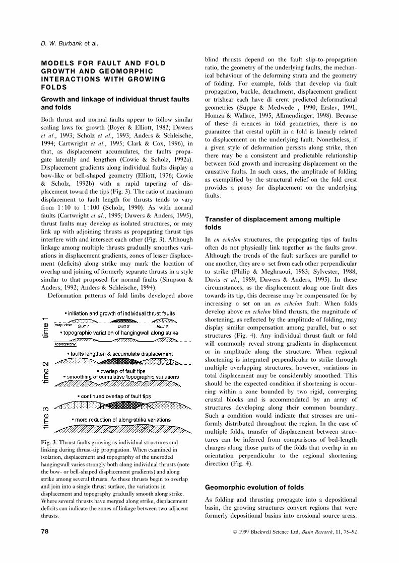
displacement to fault length for thrusts tends to varyfrom 1510 to 15100 (Scholz, 1990). As with normalfaults (Cartwright et al., 1995; Dawers & Anders, 1995), Transfer of displacement among multiplethrust faults may develop as isolated structures, or may foldslink up with adjoining thrusts as propagating thrust tipsinterfere with and intersect each other (Fig. 3). Although In en echelon structures, the propagating tips of faults
often do not physically link together as the faults grow.linkage among multiple thrusts gradually smoothes vari-ations in displacement gradients, zones of lesser displace- Although the trends of the fault surfaces are parallel to
one another, they are offset from each other perpendicularment (deficits) along strike may mark the location ofoverlap and joining of formerly separate thrusts in a style to strike (Philip & Meghraoui, 1983; Sylvester, 1988;
Davis et al., 1989; Dawers & Anders, 1995). In thesesimilar to that proposed for normal faults (Simpson &Anders, 1992; Anders & Schleische, 1994). circumstances, as the displacement along one fault dies
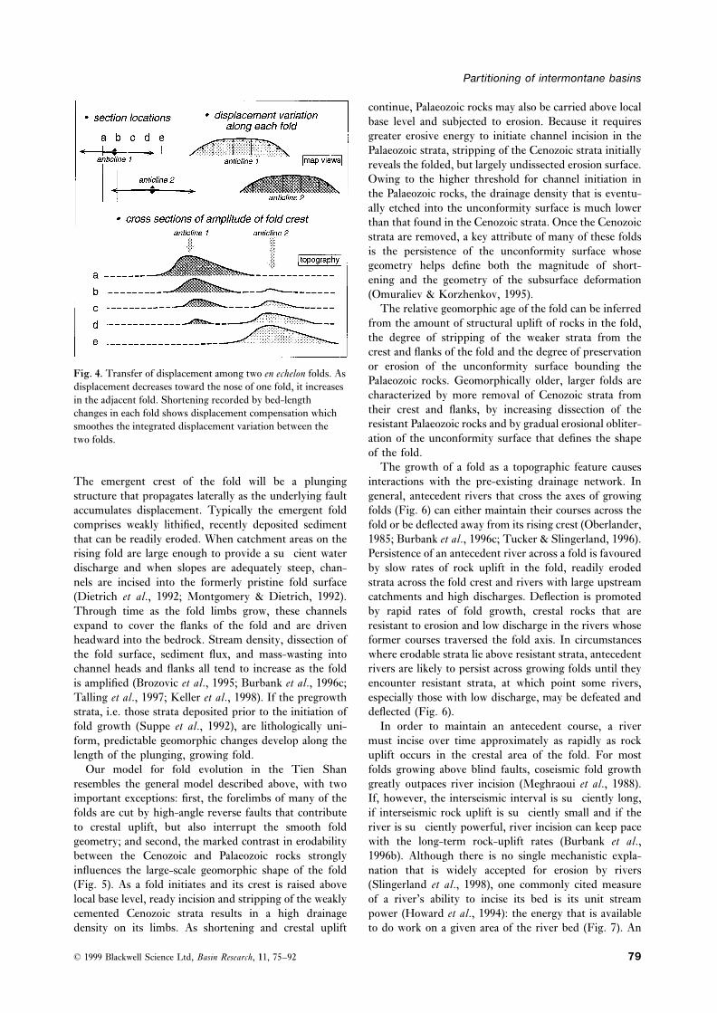
towards its tip, this decrease may be compensated for byDeformation patterns of fold limbs developed aboveincreasing offset on an en echelon fault. When foldsdevelop above en echelon blind thrusts, the magnitude ofshortening, as reflected by the amplitude of folding, maydisplay similar compensation among parallel, but offsetstructures (Fig. 4). Any individual thrust fault or foldwill commonly reveal strong gradients in displacementor in amplitude along the structure. When regionalshortening is integrated perpendicular to strike throughmultiple overlapping structures, however, variations intotal displacement may be considerably smoothed. Thisshould be the expected condition if shortening is occur-ring within a zone bounded by two rigid, convergingcrustal blocks and is accommodated by an array ofstructures developing along their common boundary.Such a condition would indicate that stresses are uni-formly distributed throughout the region. In the case ofmultiple folds, transfer of displacement between struc-tures can be inferred from comparisons of bed-lengthFig. 3. Thrust faults growing as individual structures andchanges along those parts of the folds that overlap in anlinking during thrust-tip propagation. When examined inorientation perpendicular to the regional shorteningisolation, displacement and topography of the unerodeddirection (Fig. 4).hangingwall varies strongly both along individual thrusts (note
the bow- or bell-shaped displacement gradients) and alongstrike among several thrusts. As these thrusts begin to overlapand join into a single thrust surface, the variations in Geomorphic evolution of foldsdisplacement and topography gradually smooth along strike.
As folding and thrusting propagate into a depositionalWhere several thrusts have merged along strike, displacementbasin, the growing structures convert regions that weredeficits can indicate the zones of linkage between two adjacent
thrusts. formerly depositional basins into erosional source areas.
© 1999 Blackwell Science Ltd, Basin Research, 11, 75–9278
Partitioning of intermontane basins
continue, Palaeozoic rocks may also be carried above localbase level and subjected to erosion. Because it requiresgreater erosive energy to initiate channel incision in thePalaeozoic strata, stripping of the Cenozoic strata initiallyreveals the folded, but largely undissected erosion surface.Owing to the higher threshold for channel initiation inthe Palaeozoic rocks, the drainage density that is eventu-ally etched into the unconformity surface is much lowerthan that found in the Cenozoic strata. Once the Cenozoicstrata are removed, a key attribute of many of these foldsis the persistence of the unconformity surface whosegeometry helps define both the magnitude of short-ening and the geometry of the subsurface deformation(Omuraliev & Korzhenkov, 1995).
The relative geomorphic age of the fold can be inferredfrom the amount of structural uplift of rocks in the fold,the degree of stripping of the weaker strata from thecrest and flanks of the fold and the degree of preservationor erosion of the unconformity surface bounding the
Fig. 4. Transfer of displacement among two en echelon folds. AsPalaeozoic rocks. Geomorphically older, larger folds aredisplacement decreases toward the nose of one fold, it increasescharacterized by more removal of Cenozoic strata fromin the adjacent fold. Shortening recorded by bed-lengththeir crest and flanks, by increasing dissection of thechanges in each fold shows displacement compensation whichresistant Palaeozoic rocks and by gradual erosional obliter-smoothes the integrated displacement variation between theation of the unconformity surface that defines the shapetwo folds.of the fold.
The growth of a fold as a topographic feature causesinteractions with the pre-existing drainage network. InThe emergent crest of the fold will be a plunging
structure that propagates laterally as the underlying fault general, antecedent rivers that cross the axes of growingfolds (Fig. 6) can either maintain their courses across theaccumulates displacement. Typically the emergent fold
comprises weakly lithified, recently deposited sediment fold or be deflected away from its rising crest (Oberlander,1985; Burbank et al., 1996c; Tucker & Slingerland, 1996).that can be readily eroded. When catchment areas on the
rising fold are large enough to provide a sufficient water Persistence of an antecedent river across a fold is favouredby slow rates of rock uplift in the fold, readily erodeddischarge and when slopes are adequately steep, chan-
nels are incised into the formerly pristine fold surface strata across the fold crest and rivers with large upstreamcatchments and high discharges. Deflection is promoted(Dietrich et al., 1992; Montgomery & Dietrich, 1992).
Through time as the fold limbs grow, these channels by rapid rates of fold growth, crestal rocks that areresistant to erosion and low discharge in the rivers whoseexpand to cover the flanks of the fold and are driven
headward into the bedrock. Stream density, dissection of former courses traversed the fold axis. In circumstanceswhere erodable strata lie above resistant strata, antecedentthe fold surface, sediment flux, and mass-wasting into
channel heads and flanks all tend to increase as the fold rivers are likely to persist across growing folds until theyencounter resistant strata, at which point some rivers,is amplified (Brozovic et al., 1995; Burbank et al., 1996c;
Talling et al., 1997; Keller et al., 1998). If the pregrowth especially those with low discharge, may be defeated anddeflected (Fig. 6).strata, i.e. those strata deposited prior to the initiation of
fold growth (Suppe et al., 1992), are lithologically uni- In order to maintain an antecedent course, a rivermust incise over time approximately as rapidly as rockform, predictable geomorphic changes develop along the
length of the plunging, growing fold. uplift occurs in the crestal area of the fold. For mostfolds growing above blind faults, coseismic fold growthOur model for fold evolution in the Tien Shan
resembles the general model described above, with two greatly outpaces river incision (Meghraoui et al., 1988).If, however, the interseismic interval is sufficiently long,important exceptions: first, the forelimbs of many of the
folds are cut by high-angle reverse faults that contribute if interseismic rock uplift is sufficiently small and if theriver is sufficiently powerful, river incision can keep paceto crestal uplift, but also interrupt the smooth fold
geometry; and second, the marked contrast in erodability with the long-term rock-uplift rates (Burbank et al.,1996b). Although there is no single mechanistic expla-between the Cenozoic and Palaeozoic rocks strongly
influences the large-scale geomorphic shape of the fold nation that is widely accepted for erosion by rivers(Slingerland et al., 1998), one commonly cited measure(Fig. 5). As a fold initiates and its crest is raised above
local base level, ready incision and stripping of the weakly of a river’s ability to incise its bed is its unit streampower (Howard et al., 1994): the energy that is availablecemented Cenozoic strata results in a high drainage
density on its limbs. As shortening and crestal uplift to do work on a given area of the river bed (Fig. 7). An
© 1999 Blackwell Science Ltd, Basin Research, 11, 75–92 79

D. W. Burbank et al.
Fig. 5. Structural and geomorphicdevelopment of a fold. Strong contrastsin erodability favour rapid removal ofthe overlying, weakly cemented strata,whereas the well-lithified Palaeozoicrocks resist erosion. The unconformitybetween these strata provides a reliablemarker with which to track thedeformation. With sufficient rock uplift,the bedrock also begins to besignificantly modified by erosion.
Fig. 6. Interactions of folds with rivers. a. Perspective view of a growing fold with two antecedent rivers traversing the foldtrend. The strata within the fold comprise a succession of weakly resistant strata underlain by highly resistant strata. As the foldlengthens and its crest rises, rivers initially maintain their courses because they readily incise the weak strata. When moreresistant strata are encountered, the stream with the lesser stream power is defeated and then deflected around the nose of thefold. This defeat creates a wind gap that marks the former position of the antecedent river. b. Cross-sectional view of the foldshows ready incision into weak strata, followed by defeat of one formerly antecedent stream when resistant rocks are encounteredand local stream power is insufficient to maintain the river’s course across the fold.
erosion rate based on unit stream power would be TECTONIC GEOMORPHOLOGY OF THEproportional to (Q · S)/w, where Q=discharge, S=river SOUTHERN NARYN BASINslope and w=river width. Because discharge is pro-
Growth of individual and linked foldsportional to upstream catchment area (Howard et al.,1994), river erosion rates will be enhanced by any Two types of folds are apparent in the southern Naryncombination of large catchments, steep river gradients Basin: nascent folds that have lifted only Cenozoic strata
above local base level and more fully developed foldsand narrow river widths (Fig. 7).
© 1999 Blackwell Science Ltd, Basin Research, 11, 75–9280

Partitioning of intermontane basins
Fig. 7. Schematic relationships between discharge, stream slope and channel width for antecedent streams traversing a risinganticline. Discharge is assumed to be proportional to upstream catchment area. Steep river gradients and large upstreamcatchments increase total stream power. For any given discharge and slope, specific stream power increases with decreasing riverwidth. The greater the specific stream power, the more rapidly the river is able to incise the bedrock of its bed and the morelikely it will be able to keep pace with rock uplift in a fold.
that carry Palaeozoic rocks above local base level (Fig. 8). defeated and its former course is represented by a windgap (Fig. 9b). The channels which led to this formerA clear example of the former type is found parallel to
and just south of the Naryn River at Dsilan Arik (Figs water gap are clearly preserved in the upstream alluvialsurface (Fig. 9a).2a and 9). The topographic crest of this fold sits only
400 m above the surrounding plains. The opposing noses These observations are interpreted to indicate thatonly modest unit stream power is required to incise riverof the fold plunge symmetrically at #3–4°. When the
topographic discontinuities at the water and wind gaps beds fast enough to keep pace with the rising strata.Preservation of the channels upstream of the wind gapare ignored, the crestal profile displays a broad, bell-
shaped profile (Figs 3 and 9). suggests that abandonment only occurred recently. Asmight be predicted, the smallest stream traversing theSeveral closely spaced antecedent rivers traverse the
fold axis, their gradients through the water gaps are crest of the fold was defeated first. Overall, this fold isinterpreted to typify these characteristics of the earlytypical for small rivers in active folds (0.5–2°) (Burbank
et al., 1996) and some of their catchments extend only a stages of the growth and geomorphic evolution of foldsin this area: structural uplift of only a few hundredfew kilometres into the hinterland. One stream has been
Fig. 8. Drainage map of the southernNaryn and western At Bashi basins,showing the location and orientation ofmajor structures. There are threecategories of catchment areas withrespect to structure. Those traversingacross growing folds are shown in grey.Other catchments are restricted toeither the forelimb (south side) orbacklimb (north side) of the major folds.
© 1999 Blackwell Science Ltd, Basin Research, 11, 75–92 81

D. W. Burbank et al.
and eventually Palaeozoic bedrock are raised above localbase level. As much as 5 km of fold amplification maybe required, however, before Palaeozoic rocks are raisedabove local base level. Although the Cenozoic strata tendto be stripped rapidly from the crest and flanks of thefold, several hundred metres to several kilometres ofstrata may arch across the fold crest in the early stagesof fold amplification. In any folds in which the Palaeozoicbedrock has been raised more than #500 m above theadjacent valleys, the Cenozoic strata have been entirelyremoved from the crest and upper limbs of the fold.Folds which have experienced several kilometres of rockuplift preserve hogbacks or flatirons of Cenozoic strataonly along the lower few hundred metres of their flanks(Fig. 10). On all of the large folds studied in the southernNaryn Basin, the unconformity at the base of theCenozoic strata is extensively preserved across their flanks(Fig. 10a). Topographic profiles following the exhumedunconformity surface along the crests of the folds(Fig. 12) show gradients in the altitude of the folds’crests that are geometrically similar to those shown bythe nascent fold (Fig. 9), but which are greatly amplified.The magnitude of crestal uplift is as much as 2 km abovelocal base level along these structures that are 20–50 kmlong and have noses that plunge at 6–12°. Slope anglesfor the exposed unconformity surface on the backlimb ofthese folds were calculated based on a 3-arcsecond DEMof the region. Despite the expected broadening ofthe slope distributions owing to moderate dissection ofthe unconformity surface by fluvial channels, most of theslopes on each fold cluster within a few degrees of eachother (Fig. 13).
Two of the folds (Xrebet Kara Too and Karacha) showsimple along-strike crestal profiles. The largest departuresfrom a smoothly varying profile occur above #3500 m(Fig. 12). We interpret these topographic irregularitiesto have resulted from glacial erosion and periglacialprocesses that have incised several hundred metres belowthe unconformity surface. Despite these topographic
Fig. 9. a. Young, growing fold on the south side of the Naryn departures, the overall smooth profiles are interpreted asRiver (see Fig. 2b for location). The surface of the fold has been
a response to growth of a single propagating fault beneathmodified by fluvial erosion on both flanks. Antecedent riverseach fold. If this interpretation were correct, it would becut through the fold in several locations. Only one major windexpected that the backlimb of the fold would displaygap has developed and defeat of the antecedent river there isuniform slope angles along its length. Our field obser-recent as evidenced by the clear upstream channels leading tovations on the unconformity surface support this infer-the present wind gap. b. Despite considerable dissection of the
uplifted Cenozoic strata, a topographic profile along strike ence. Moreover, slope angles calculated on the backlimbsillustrates the bow-shaped, smoothly varying amplitude of of the folds (Fig. 13a) clearly show that most of thecrestal uplift along the fold axis and the positions of the water slopes cluster tightly around the mean slope angle, despiteand wind gaps along its length. c. Across-strike profiles depict the ongoing dissection of the unconformity surface.the widening of the fold as it gains displacement, but reveal The Gory Baybeiche profile is more complex. Alonglittle about the internal fold geometry. the 45-km length of the fold, multiple summits and
broad exposures of the unconformity are located at#3500 m (Fig. 12). In contrast to the other two folds,metres, ready incision by antecedent rivers, a high density
of small streams developed in Cenozoic strata on the fold the overall altitudinal variation of the fold crest along theGory Baybeiche structure is smaller. Two major waterflanks and considerable modification of the fold shape
due to dissection of poorly indurated strata (Figs 5 and 9). gaps and several wind gaps interrupt this elongate, ratherbox-like profile. Satellite images (Fig. 2a) and mappingAs shortening and crestal uplift continue in the sou-
thern Naryn Basin, greater thicknesses of Cenozoic strata indicate additional faults with commonly small
© 1999 Blackwell Science Ltd, Basin Research, 11, 75–9282

Partitioning of intermontane basins
displacements (<150 m at the surface) that cut through the fold, this apparent deflection suggests that coseismicuplift near the nose of the propagating fold causedthe backlimb of the fold. We interpret the elongate
topographic profile with concordant crestal elevations as westward avulsion into the undeformed floodplain.Near the western terminus of the Xrebet Kara Tooresulting from the linkage of several structures whose
former terminations are marked by the present water fold, a wind gap (Fig. 10b) provides key evidence con-cerning interactions of folds and river systems. The windgaps. By analogy with our models (Fig. 3), linkage has
led to smoothing of the amplitude gradients along the gap is #1.5 km east of and #80 m above the structuraland topographic low point where two folds join andfolds. Additional evidence for linkage of several structures
derives from the clear traces of multiple faults that cut where the present Kara Bulun River crosses the folds viaa water gap at or near their juncture. Basal Cenozoicthe backlimb of the folds and display bow-shaped gradi-
ents in the amplitude of offset along these traces. strata exposed adjacent to the wind gap arch across thefold crest (Fig. 10b). South across the Kara Bulun valleyFurthermore, histograms of slope angles (Fig. 13b) show
consistent slopes within each individual region of the from the wind gap, there are alluvial surfaces whichproject toward the present wind gap and which presentlyfold limb that is delimited by a fault, but contrasting
slopes between these regions. An alternative explanation are isolated #40–50 m above the modern valley floor.These alluvial surfaces suggest that a river was flowingwould be that the pattern of rock uplift along Gory
Baybeiche is simply more box-like with strong displace- through the present wind gap at the time those surfaceswere active. The low point of the wind gap coincidesment gradients at the extremities and very little variation
within the intervening part of the structure. This pattern with the unconformity surface. Presently exposed at thissite, the presence of karstic breccias that developed onis less compatible with the systematic changes in ampli-
tude displayed by the other folds (Figs 9 and 11), but the Palaeozoic carbonates as the unconformity was formedindicate very limited dissection of the unconformitymay represent another mode of fault-fold growth in
which abrupt structural discontinuities, such as lateral surface has occurred. The observations that this lowpoint coincides with the first resistant, i.e. Palaeozoic,ramps or tear faults, determine the lateral extent of fold
growth (Mueller & Talling, 1997). bedrock and that the alluvial surfaces across the valleyproject toward the low point suggest that abandonmentof the former water gap occurred at the time theseWind gaps, water gaps and fold propagationresistant rocks were first encountered (Fig. 6). At thattime, the bedrock resistance is interpreted to haveAs has been observed in other growing folds (Burbank
et al., 1996c; Jackson et al., 1996; Keller et al., 1998), as exceeded the unit stream power of the traversing riverand caused its deflection westward into the water gapfolds rise and widen, formerly antecedent rivers may be
defeated and diverted either around the nose of the fold where the Kara Bulun River presently flows.At the Kara Bulun water gap, only the uppermost(Fig. 6) or into a river already traversing the fold, but
crossing closer to its propagating nose. When the lateral Palaeozoic bedrock is exposed at the surface (Fig. 11).One might wonder whether this river will soon betips of thrust faults and overlying fold noses propagate
toward each other, it would be expected that rivers defeated, too. This appears unlikely in the short term,because the present water gap is localized in a structuraldeflected out of previous antecedent courses would be
focused toward the zone of linkage between the two and topographic low between two growing folds: there isno lower position to which the river can be diverted. Itstructures (Fig. 12), whereas wind gaps along the fold’s
crest would mark the former courses of transverse rivers is possible that, as the fold amplifies, the river will notbe able to keep pace with the rock uplift rate. Rather( Jackson et al., 1996).
Along the crest of the Gory Baybeiche fold, there are than resulting in abandonment, however, this may simplycause the upstream catchment to aggrade as the relativewind gaps presently at an altitude of #3000–3400 m
(Fig. 12). These rivers only succeeded in incising a few elevation of the river bed across the fold crest increasesand as the river gradient steepens downstream of thehundred metres into the Palaeozoic rocks before they
were defeated. Presently, the backlimb of the Baybeiche crest.structure is etched by channels that originate on theunconformity surface and have incised #5–20 m through Unit stream power through water gapsit (Fig. 2a). The Karacha fold is interrupted near itswestern terminus by the water gap of the modern At Three types of catchment geometries are displayed in
the vicinity of the southern Naryn folds (Fig. 8): (1)Bashi River, which cuts a gorge several hundred metresdeep (Fig. 12). The course of the river turns abruptly catchments that extend to the crest, but not across the
fold axis; (2) ‘hourglass-shaped’ catchments that extendwestward several kilometres prior to crossing the foldaxis. We interpret this pattern to result from deflection through the fold crest and contain water gaps; and (3)
catchments on the upstream side of the folds that containof the river during early growth and topographic emerg-ence of the anticline. Given the large discharges of the deflected rivers flowing away from or parallel to the folds.
Two catchments that feed antecedent rivers transectingAt Bashi River, it should be able to incise successfullyinto any rising fold. Rather than incising vertically into Gory Baybeiche (Fig. 14) vary by a factor of #4–5 in
© 1999 Blackwell Science Ltd, Basin Research, 11, 75–92 83

D. W. Burbank et al.
© 1999 Blackwell Science Ltd, Basin Research, 11, 75–9284

Partitioning of intermontane basins
on the bed per unit width. This provides a mechanismfor maintaining the course of both rivers across the fold,despite their differences in catchment area. Alternatively,this could be conceptualized as the river adjusting itswidth until its specific stream power is sufficient to driveerosion of its bed at a rate equal to the rock uplift rate.
Displacement transferFig. 11. Structural and geomorphic relationships near the nose
When the tips of two, oppositely plunging, en echelonof the plunging Xrebet Kara Too fold. Nearly all Cenozoicfolds have propagated past each other, our model suggestsstrata have been stripped off the older Kara Too fold to thethat shortening can be partitioned between them, sucheast. Two wind gaps, each floored by resistant Palaeozoic
bedrock, reflect progressive abandonment of antecedent courses that the total shortening across them remains constantas the fold grew in amplitude and propagated laterally. despite variations on an individual structure (Fig. 4).
The overlapping and oppositely plunging noses of theGory Baybeiche and Xrebet Kara Too structures providetheir areas and presumably in their discharges, given that
they are immediately adjacent to one another so that they a unique opportunity to assess the trade-off in shorteningbetween these folds (Fig. 2). Topographic profiles con-should experience similar distributions of precipitation.
A steeper river gradient in the smaller catchment, in structed roughly perpendicular to the fold axes androughly parallel to the shortening direction (Fig. 15)combination with an observed bankfull width that is
#40% narrower than in the gorge of the larger catch- exhibit characteristics predicted by our model for transferbetween folds whose noses overlap: as one fold dies inment, results in a unit stream power that is nearly equal
(Fig. 14) between the two catchments. This equality amplitude, the adjacent one grows (Fig. 4). The amountof shortening could be quantified, if a similar structuralsuggests that, as the rivers cut through the water gap
and encounter the rising folds, they expend similar energy level could be followed across both folds. The unconform-
Fig. 12. Longitudinal topographic profiles along the bedrock folds show bow-shaped displacement gradients. Especially near thetermini of the folds, the unconformity surface capping the Palaeozoic bedrock has been little modified by erosion. Consequently,the topography mimics the displacement. Prominent water gaps, such as that occupied by the At Bashi River in the Karachafold, occur near the tips of some structures. Note the wind gaps preserved along several of the folds. The elongate, box-likeprofile of the Gory Baybeiche structure is interpreted to result from along-strike linkage of several folds. Water gaps through theGory Baybeiche fold are interpreted to correspond with zones where folds propagating toward each other subsequently linkedup. See Fig. 2(b) for location.
Fig. 10. a. Cenozoic strata unconformably overlying Palaeozoic strata along the northern flank of the Xrebet Kara Too fold. Notethe parallelism of the Cenozoic bedding and the unconformity, indicating that the unconformity was essentially horizontal duringat least the initial stages of Cenozoic deposition. Hence, deformation of that surface post-dates early Cenozoic deposition. Exceptin a few isolated pockets, Cenozoic strata have been stripped from the folded unconformity surface. High-angle (#70°) reversefaults cut the forelimb near the fold crest and juxtapose Cenozoic Shamsi beds with younger Chu strata. b. View down-plunge tothe west along the Xrebet Kara Too fold. Basal Cenozoic strata arch across the wind gap (middle ground) and define the crest ofthe fold. The wind gap is floored by karstic weathering developed along the unconformity surface, suggesting that the wind gapwas abandoned at the time that the resistant Palaeozoic strata were encountered by the formerly antecedent river. In thebackground, a younger fold displays less shortening, a thick mantle of Cenozoic strata on its backlimb and high-angle thrustscutting its forelimb. c. View east along syncline between the Gory Baybeiche fold and the westward extension of the Kara Toofold (left). The unconformity is folded across the steep forelimb of the Kara Too fold and rises abruptly on the uniformlydipping backlimb of the Gory Baybeiche fold. Cenozoic strata have been eroded down to the altitude of the Palaeozoic strata inthe crest of the outer, northerly fold.
© 1999 Blackwell Science Ltd, Basin Research, 11, 75–92 85

D. W. Burbank et al.
Fig. 15. Topographic profiles across the oppositely plungingand overlapping termini of the Gory Baybeiche and Xrebet
Fig. 13. Distributions of slope angles on the back limb of the Kara Too folds. The lines of the topographic profiles are(a) Kara Too and (b) eastern Gory Baybeiche folds. Slope orientated roughly perpendicular to the fold axes. Except lowangles are calculated on a 3×3 grid (#180×180 m) using a 3- on the flanks where Cenozoic strata remain, the topographicarcsecond DEM. Despite dissection of these surfaces, clear surface of both folds is defined primarily by the unconformitymean slope angles are apparent. The double peak on Gory surface, such that a similar structural level is being measured inBaybeiche occurs in that part of the fold where a prominent each fold. Note the similarity of the topographic profiles to thatthrust offsets the unconformity surface. The steeper slopes predicted when deformation is transferred between twooccur on the hangingwall of that thrust which is more rotated oppositely growing structures (Fig. 4): as one dies, the otherthan its footwall. grows, and the total shortening remains fairly constant along
strike. For location of the cross-sections, see Fig. 2(b).ity surface represents such a level and provides anexcellent marker on the backlimbs of these folds. In smoothed across the two folds and averages #9% (Fig.
16). This is less than the total shortening because it failscontrast, on the fold forelimbs, the unconformity may beeroded or buried by talus or by Cenozoic strata, such to account for folding of the unconformity surface in the
buried forelimbs of the folds.that it does not coincide with the geomorphic surface.Considering the unconformity surface solely on the back-limbs of the structures, the shortening ranges from 0 to Structural geometry17% on the individual folds (Fig. 16). When the back-limbs of both structures are considered on transects Depending on its location, a structure section across the
strike of the ranges of the southern Naryn Basin couldperpendicular to strike, the total shortening is greatly
Fig. 14. Two catchments crossing GoryBaybeiche fold vary by 400–500% withrespect to the catchment area upstreamof the water gap and by 250–300% intotal stream power. Despite the contrastbetween the two catchments in theaverage slope of the river, the specificstream power is calculated to be nearlyequivalent between them. See Fig. 8 forlocation.
© 1999 Blackwell Science Ltd, Basin Research, 11, 75–9286

Partitioning of intermontane basins
rocks just breach the present-day surface. The backlimbof this fold dips 20–25° to the NNW before being foldedinto a gentle syncline and cut by a steep (#60°) reversefault that offsets the Palaeozoic rocks and splays intomore gently dipping faults (<30°) as it branches intothe Cenozoic strata #4 km north of the southern fold.These faults define the southern limit of the Kara Toostructure as it dies toward the east. Another 4 km to thenorth, the Karacha structure is defined by a forelimbthat is cut in places by a steep (75°) reverse fault (Fig.13). The Palaeozoic rocks at the crest of the Karacha
Fig. 16. Shortening along the backlimbs of the Kara Too and structure define #7 km of structural relief with respectGory Baybeiche folds. Shortening is calculated along the to the position of the top of the Palaeozoic rocks in theexposed unconformity surface and assumes bed length is At Bashi basin 15 km to the south (Fig. 17). In thepreserved in the backlimb. Despite large variation along either Cenozoic strata to the north of Karacha, dips decreasefold, the mean shortening remains quite constant when both
to #5–10° across much of the southern Naryn Basin.folds are considered in a transect as shown in Fig. 15. ForBecause we lack detailed subsurface data in this area,location of transect, see Fig. 2(b).
numerous structural geometries could be compatible withour surface observations. Our structural interpretation isinfluenced by recent seismic data from elsewhere in theKyrgyz Tien Shan (Roecker et al., 1993; Ghose et al.,1996; Mellors et al., 1997) which suggest that reversefaults with dips of about 45° often rupture upwardthrough 15–20 km of seismogenic crust. In the studyarea, our surface observations of reverse faults dipping65–80° suggest that the deeper faults may steepen withinthe Palaeozoic rocks near the surface. As Cenozoic strataare encountered by these faults, they become much lesssteep (<30°) at a few sites. Fold geometries and dips offaults at the surface are consistent with an overall south-ward vergence in the study area.
Geometric constraints imposed by the relative altitudeof the unconformity surface within the ranges suggestthat, at the start of growth of the faulted folds describedhere, the bedrock beneath the Naryn Basin was flexedFig. 17. Structural cross-section across the southern Naryn andasymmetrically toward the north. We hypothesize thatnorthern At Bashi basins. The geometry is based on athe load of the ranges bordering the northern basin alongbreakback thrust sequence and utilizes the forward trishearthe Nikolai Line (Fig. 1) drove this subsidence andmodel of Allmendinger (1998) to determine the simplified
deformational geometry. imposed an #5° northward dip on the unconformitysurface in the study area. Each of the folds is interpretedto result from a two-stage deformation process. First, aencounter 1–3 large-scale folds or faults involving the
Palaeozoic bedrock. A transect located #1–3 km east of fold developed above the propagating tip of a fault thatcut through the seismogenic layer at an angle of 45–50°the At Bashi River encompasses three such faulted folds
(Figs 2b and 17). Steep reverse faults, typically dipping (Fig. 17). Near the base of the seismogenic crust, thefaults become less steep as they merge into a zone of65–85° to the NNW, cut the crests or forelimbs of the
folds, and commonly offset the unconformity surface by diffuse deformation in the ductile lower crust. Second,as the fault approached the surface, it steepened to the<1 km. The primary structure in the southern part of
the transect is a large, south-vergent fold which we name 65–80° dips observed at the surface today. The dip ofthe backlimbs of the folds results from the steepeningthe At Bashi fold. A continuous panel of Cenozoic strata
dipping #55–35° southward in the forelimb indicates of the causative faults within the upper parts of thePalaeozoic rocks.that the structural relief on the fold is approximately
5 km (Fig. 17). Remarkably, despite the structural relief,the At Bashi fold has almost no geomorphic expression. Reconstruction of the sequence ofThe crest of the anticline is cut by a steep reverse fault deformationthat carries the uppermost, slightly overturned Palaeozoicrocks over lower Cenozoic strata in the footwall and has In the absence of reliable chronological control on the
timing of each structure, we rely on structural andan apparent throw of approximately 0.5 km. At thehighest segments of the anticlinal crest, the Palaeozoic geomorphic criteria to predict the deformation sequence.
© 1999 Blackwell Science Ltd, Basin Research, 11, 75–92 87

D. W. Burbank et al.
First, we assume that as thrust-related folds develop, the position of these surfaces with respect to datedterraces in the Naryn Basin, they are interpreted to bethey follow a predictable pattern of progressive erosion
(Fig. 5), such that degree of preservation of the uncon- middle Pleistocene in age. More importantly, even thoughthey are cut across the axis of the fold, they are essentiallyformity surface or the dissection and removal of the
Cenozoic strata can be used as a proxy for relative age. undeformed, indicating that the underlying fold has notbeen active since the middle Pleistocene (>130 ka).Second, if faults offset geomorphic features, they are
considered active. Third, the presence or absence of The en echelon Gory Baybeiche, Kara Too and Karachastructures are interpreted to have developed next.folding of geomorphic markers, such as fluvial terraces,
indicates the degree of recent activity on an underlying Although the sequencing of development of these threestructures is not unequivocal, Kara Too is interpreted asfold. Fourth, a fold that deflects a river that flows in an
undeflected course past the nose of second fold is younger the first to form, based on geomorphic criteria. It is thefold with the greatest relief, greatest dissection of thethan the second fold. Fifth, in the absence of active faults
or deformed geomorphic features, we assume that, once unconformity surface along its backlimb and most erosionof the Palaeozoic bedrock in its higher, glaciated reaches.folding begins, the rates of shortening do not vary greatly
among individual folds. This assumption would be invalid Apparently young fault scarps and the recently abandonedwind gap at its west end (Fig. 11) suggest that Kara Tooif, for example, a fold initiated at 2 Ma, but had a growth
rate that was 60% slower than a fold that commenced at is still propagating westward. Gory Baybeiche andKaracha have many similarities, but Gory Baybeiche is1 Ma. At present, we cannot test this assumption. Based
on these assumptions, older folds display higher relief, inferred to have formed earlier, because its unconformitysurface is slightly more dissected, its elongate crest seemsgreater incision of Palaeozoic bedrock, more extensive
removal of Cenozoic strata, and less continuity of the to have formed from linkage of several faults at depthand it is being cut more extensively by younger faultsfolded unconformity surface, whereas the younger folds
have lower relief, more Cenozoic cover, less Palaeozoic along its backlimb. Like the Xrebet Kara Too and GoryBaybeiche structures, the Karacha fold is almost com-bedrock exposed, less dissection of the unconformity
surface and clearer association with deflected rivers. pletely stripped of Cenozoic strata. The At Bashi Riverhas been deflected and then trapped in a water gap alongThe reconstructed fold-growth sequence (Fig. 18)
indicates that deformation began with growth of the At Karacha’s eastward propagating nose, whereas the riveris undeflected by the Kara Too structure. We interpretBashi fold in the south. The 5 km of structural relief is
the largest on any structure in the section. Nonetheless, this geometry to indicate that the growth of Karachapost-dates that of Kara Too. The small fold to the westthere is almost no geomorphic expression of this fold,
because the Palaeozoic rocks barely reach the geomorphic of Kara Too (fold 5, Fig. 18) exposes Palaeozoic bedrockin its forelimb, but it has little relief and is mantled insurface. West of the At Bashi River, a southward-sloping
pediment surface and straths which were cut into the several places by hundreds of metres of Cenozoic strata.The youngest folds to the north and south of the GoryCenozoic strata across the axis of the At Bashi fold are
presently isolated 300–600 m above the river. Based on Baybeiche only expose Cenozoic strata, are readily crossed
Fig. 18. Reconstructed deformationsequence in the southern Naryn Basin.Criteria for assigning age are describedin the text. Examples of basinasymmetry are interpreted to reflecttilting of the bedrock, whereas deflecteddrainages represent either streamcapture or propagating fold noses. AB:At Bashi fold; GB: Gory Baybeiche;KR: Karacha; KT: Kara Too; DA:Dsilan Arik.
© 1999 Blackwell Science Ltd, Basin Research, 11, 75–9288

Partitioning of intermontane basins
by small rivers and have low (<500 m) structural and then dissect the Palaeozoic bedrock (Fig. 5). Given thefact that the Cenozoic strata were 5 km thick in thistopographic relief. The fold to the north by Dsilan Arik
(Fig. 9a) displays tilted fluvial terraces in the forelimb of region, an alternative hypothesis can be envisaged: therivers responded to geometries of folding in the Cenozoicthe fold, whereas, to the south, there are active faults
bounding the south limb of the structure. Examples of strata far above the unconformity surface and have simplybeen ‘let down’ on to the already folded Palaeozoic rocks.river capture, highly asymmetric drainage basins and
deflection of drainages (Fig. 18) attest to the dynamic In this scenario, the wind and water gaps found today inthe Palaeozoic rocks would result simply from compe-nature of the drainage system in this actively deforming
landscape. tition among drainages on a passive landscape that hadalready been deformed, rather than a record of thecontinued growth of these structures. We argue againstDISCUSSIONthis interpretation for the following reasons. The slopesof the floors of the wind gaps and of the fluvial terracesNumerous models for the development of thrust-relatedwithin them are sufficiently steep to suggest they havefolds have been recently described (e.g. Suppe, 1983;been deformed since abandonment. Even small riversJamison, 1987; Medwedeff, 1989; Suppe, 1992; Shaw &commonly maintain their courses across folds of CenozoicSuppe, 1994; Poblet & Hardy, 1995; Wickham, 1995;strata, so that their deflection appears to result fromVerges et al., 1996; Ford et al., 1997; Poblet et al., 1997;encounters with the deforming Palaeozoic rocks. TheSuppe et al., 1997; Allmendinger, 1998), but most ofease of stripping of the Cenozoic strata, in combinationthese consider only two-dimensional cross-sections.with the magnitude of structural relief on the unconform-Analysis of folds in three dimensions is considerably lessity surface (>7 km), dictates that the Palaeozoic rockscommon (Philip & Meghraoui, 1983; Medwedeff, 1992;would have emerged as geomorphic entities during defor-Burbank et al., 1996a; Jackson et al., 1996; Mueller &mation, not after it. Seismicity and apparently recentTalling, 1997; Keller et al., 1998). Growing folds in thefaulting indicates that several of the major bedrocksouthern Naryn Basin of the Kyrgyz Tien Shan providestructures are still active.a natural laboratory in which the evolution of thrust-
Several intriguing aspects of these bedrock-involvedrelated folds can be documented. In many areas of thefolds emerge from this study. When the amplitude ofworld, growing folds carry only readily erodable Cenozoicthe structures is only a few hundred metres, the uncon-strata above local base level, such that the morphologyformity surface can be continuously and smoothly tracedof the fold is often obliterated by erosion soon after beingover the fold crest into both limbs. All of the largerraised above local base level. In the Tien Shan, thestructures have high-angle reverse faults cutting theirpresence of resistant Palaeozoic bedrock in the limbs ofcrests or forelimbs, and it is usually impossible to tracemany folds guarantees their persistence as geomorphicthe unconformity within the footwall. Cenozoic strata inentities, whereas the widespread unconformity that wasthe footwall adjacent to the faults typically dip steeplybevelled across the Palaeozoic rocks provides a robustto the south and indicate considerable folding prior tostructural marker for tracking deformation.fault propagation to the surface. The backlimbs of eachDuring the initial stages of fold growth, slightly indu-fold display remarkably uniform dips along strike, sug-rated Cenozoic strata are raised above local base levelgesting that the underlying causative fault maintains aand subjected to erosion. The presence of multiple,consistent geometry along its length as it propagatesclosely spaced antecedent streams which transect suchlaterally and vertically. Where there is more than onefolds and the highly irregular topography of their emerg-fault cutting the fold crest or backlimb, the backlimb dipent limbs attest to the rapid geomorphic modification ofangles, although highly consistent within the regionthe initial structural shape. Although net erosion doesaffected by a given fault, vary strongly between regionsnot fully balance the rock uplift on these young structures,associated with different faults (Fig. 13).typically #20–40% of the volume above local base level
It is presently unknown how much limb thinning orhas been eroded in these low-relief folds (Fig. 9). Inthickening occurs in these folds or precisely how thecontrast, emergent Palaeozoic bedrock on the fold flanksshape and amplitude of the fold is related to displacementis far more persistent. Efficient erosional stripping of theon the underlying faults. We suggest that, because themantle of Cenozoic strata reveals the folded unconformitybacklimb dips are so laterally persistent, the faultsurface that faithfully records the geometric shape of thegeometry is also laterally persistent. Therefore, evenbacklimbs of the growing folds. Under the present climate
conditions, the exposed unconformity surface is little though the fault geometry is not well defined, the relativedisplacement on these faults can be assessed using thedissected, even when it is exposed over vertical distances
exceeding 1000 m. In such cases, the present topographic magnitude of deformation of the folds formed abovethem.surface also defines much of the fold geometry.
Our reconstruction of the sequence of deformation In many fold-and-thrust belts, weak units in formerpassive margin successions are exploited as detachmentrelies on assumptions about the geomorphic evolution of
folds in the Tien Shan. Of particular importance are the horizons (Baker et al., 1988; DeCelles et al., 1995) and,in many cases, the ramps step-up into the foreland-basinsequential steps through which surface processes strip
the Cenozoic strata off the unconformity surface and fill, such that the young folds involve only synorogenic
© 1999 Blackwell Science Ltd, Basin Research, 11, 75–92 89
D. W. Burbank et al.
strata (Davis et al., 1989; Shaw & Suppe, 1994; Burbank seismicity (Roecker et al., 1993; Abdrakhmatov et al.,et al., 1996c). This is clearly not the case here, where 1996; Ghose et al., 1996, 1998; Mellors et al., 1997).upper crustal thrusting occurs on ramps that extend Modern deformation in other fold-and-thrust belts sug-many kilometres into the crust (Mellors et al., 1997). gests that distributed shortening and coeval displacementPerhaps this is attributable to the Palaeozoic orogenies may be common phenomena (Seeber et al., 1981; Daviswhich created complex bedrock geometries (Burtman, et al., 1989; Hauksson, 1990). Accurate calculation of1975; USSR ANKSaMoG, 1980) in which there are no shortening across these folds, assessment of rates ofregionally persistent, rheologically weak layers in a deformation and their contribution to the geodeticallyfavourable orientation to be exploited by propagating determined rate of 20 mm yr−1 of shortening across thefaults. Although the obvious rheological contrast between entire Tien Shan, and better documentation of subsurfacethe Cenozoic strata and the Palaeozoic bedrock could be fault geometries await further study.utilized, it is not the primary detachment surface here.
Simple models and some field studies from other areasCONCLUSIONS(Dawers & Anders, 1995) suggest that the shortening
integrated across multiple folds and faults can serve to We have documented the growth of a suite of thrust-smooth regional variations in displacement. Although related folds bounding the modern Naryn Basin in thestrong variations in fold amplitude and shortening can central Tien Shan. Their development partitioned aexist along strike for any given fold, the suite of en formerly, much larger depositional basin into two modernechelon faulted folds in the southern Naryn Basin provides subbasins which are dominated by erosion. The geo-evidence for a transfer of shortening among adjacent morphic evolution of these folds is strongly dependentstructures that smoothes the overall displacement vari- on the particular stratigraphy of the Kyrgyz Tien Shan:ations perpendicular to the fold axes. Whereas the tips #5 km of Cenozoic strata overlying a regionally extensiveof these en echelon folds are propagating past each other, unconformity cut across rocks deformed in two Palaeozoicother folds, such as at Gory Baybeiche, appear to have orogenies. The contrast in erodability between these twodeveloped along strike from each other and to have linked units permits the relative preservation of both theup during growth. Such linkage also serves to smooth Cenozoic strata and the unconformity surface to be useddisplacement variations along strike. as proxies for the geomorphic age of a structure. Along
Fold-and-thrust belts have traditionally been viewed as the length of a fold, systematic changes in the dissectionmigrating systematically away from the hinterland in space of the stratigraphy and in fold amplitude correlate withand time. It has also been common to envisage that only
the lateral propagation of the underlying causative faults.one thrust was active at a time and that deformation
Uniform dips of the backlimbs of a given fold suggesttransferred to a new structure only when shortening died
remarkably consistent fault geometries along strike. Byor waned on previously active structure. Although recog-equating the geomorphic age with a relative geologicalnition of synchronous and out-of-sequence thrustingage, we define a deformational sequence that includes(Martınez et al., 1988; Morley, 1988; Verges & Munoz,both break-forward and break-back thrusting, rather than1990; Boyer, 1992; Burbank et al., 1992; DeCelles et al.,a systematic progression of deformation in one direction.1995) and the predictions of critically tapered wedgeSuch a sequence is consistent with the broadly distributedmodels (Davis et al., 1983; Dahlen & Suppe, 1988; Dahlen,seismicity and the presence of multiple, late Pleistocene1990; Willett, 1992; Willett et al., 1993; Masek & Duncan,to Holocene faults within and adjacent to the ranges of1998) under conditions of nonuniform erosion indicatethe Tien Shan.that thrust sequencing is not uniformly away from the
hinterland, the specification of the actual sequence ofinitiation and motion of thrusts is often difficult to docu- ACKNOWLEDGEMENTSment (Meigs, 1997). Here in the Naryn and At Bashi
This research was supported by the NSF Continentalbasins, our reconstruction of the structural evolutionDynamics program (EAR 9614765). We profited fromsuggests that deformation is distributed in space, thatour introduction to the study area by V. Makarov,multiple structures are active simultaneously and that theI. Sadybakasov, A. Korchenkov, O. K. Chediya andinitiation of deformation does not migrate systematicallyP. Molnar, and the support of personnel from the Kyrgyzacross the basin.Institute of Seismology, Kyrgyz Institute of Geology,The distributed shortening in this small region of theand IVTRAN, particularly director Y. A. Trapeznikov.Tien Shan may be representative at the scale of theSpecial thanks are extended to A. Mikolaichuk, T.entire range of the way in which shortening is accommo-Charimov and Ottar Abdrakhmatov for their extensivedated. Almost every range front is characterized by thrustassistance and expertise in the field. Field observations,fault scarps indicating recent displacement and thediscussions and reviews of this paper by R. Weldon,Cenozoic strata within many basins are being disruptedJ. Lave, S. Thompson, P. Molnar, and C. Rubin con-by growing structures. The accommodation of conver-tributed immeasurably to this work. We are grateful togence between the Tarim Basin and the Kazakh platformRichard Allmendinger for sharing his trishear forwardby shortening on multiple structures is consistent both
with the modern geodetic data and with the recent modelling program and to K. Mueller, N. Pinter and
© 1999 Blackwell Science Ltd, Basin Research, 11, 75–9290

Partitioning of intermontane basins
belts and accretionary wedges. Ann. Rev. Earth Planet. Sci.,two anonymous reviewers for their incisive critiques of18, 55–99.an earlier version of this paper.
D, F.A. & S, J. (1988) Mechanics, growth, anderosion of mountain belts. In: Processes in Continental
REFERENCES Lithospheric Deformation (Ed. by S.P.J. Clark, B.C. Burchfiel& J. Suppe), pp. 161–178. Geological Society of America,A, K.Y., A, S.A., H, B.H., et al.Denver.(1996) Relatively recent construction of the Tien Shan
D, T.L., N, J. & Y, R.F. (1989) A cross sectioninferred from GPS measurements of present-day crustalof the Los Angeles area: seismically active fold and thrustdeformation rates. Nature, 384, 450–453.belt, the 1987 Whittier Narrows earthquake, and earthquakeA, R.W. (1998) Inverse and forward numericalhazard. J. Geophys. Res., 94, 9644–9664.modeling of trishear fault-propagation folds. Tectonics, 17,
D, D., S, J. & D, F.A. (1983) Mechanics of fold-640–656.and-thrust belts and accretionary wedges. J. Geophys. Res.,A, M.H. & S, R.W. (1994) Overlapping faults,88, 1153–1172.intrabasin highs, and the growth of normal faults. J. Geol.,
D, N.H. & A, M.H. (1995) Displacement-length102, 165–180.scaling and fault linkage. J. Struct. Geol., 17, 607–614.B, D.M., L, R.J., Y, R.S., J, G.D.,
D, N.H., A, M.H. & S, C.H. (1993) GrowthY, M. & Z, A.S.H. (1988) Development of theof normal faults: Displacement-length scaling. Geology, 21,Himalayan thrust zone: Salt Range, Pakistan. Geology, 16,1107–1110.3–7.
DC, P.G., L, T.F. & M, G. (1995) ThrustB, S.E. (1992) Geometric evidence for synchronous thrust-timing, growth of structural culminations, and synorogenicing in the southern Alberta and northwest Montana thrustsedimentation in the type Sevier orogenic belt, westernbelts. In: Thrust Tectonics (Ed. by K.R. McClay), pp. 377.United States. Geology, 23, 699–702.Chapman & Hall, London.
D, W.E., W, C.J., M, D.R., MK,B, S.E. & E, D. (1982) Thrust systems. Am. Asso.J. B, R. (1992) Erosion thresholds and land surfacePetro. Geol. Bull., 66, 1196–1230.morphology. Geology, 20, 675–679.B, N., B, D.W., F, E. & M, A.J.
E, D. (1976) The energy balance and deformation mech-(1995) The spatial and temporal topographic evolution ofanisms of thrust sheets. Phil. Trans. Royal Soc. Of London,Wheeler Ridge California: New insights from digital elevation283, 289–312.data. Geol. Soc. Am. Abstr. With Prog., 27, 396.
E, E.A. (1991) Trishear fault-propagation folding. Geology,B, D.W., B, R.A. & M, T. (1996a) The19, 617–620.Himalayan Foreland. In: Asian Tectonics (Ed. by Y. An &
F, M., W, E.A., A, A., V, J. & H,M. Harrison), pp. 149–188. Cambridge University Press,S. (1997) Progressive evolution of a fault-related fold pairCambridge.from growth strata geometries, Sant Llorenc de Morunys,B, D.W., L, J., F, E., A, R.S.,SE Pyrenees. J. Struct. Geol., 19, 413–441.B, N., R, M.R. & D, C. (1996b) Bedrock
G, S., H, M.W. & V, J. (1998) Three-incision, rock uplift, and threshold hillslopes in the north-dimensional velocity structure and earthquake locationswestern Himalaya. Nature, 379, 505–510.beneath the northern Tien Shan of Kyrgyzstan, central Asia.B, D.W., M, A. & B, N. (1996c) InteractionsJ. Geophys. Res., 103, 2725–2748.of growing folds and coeval depositional systems. Basin Res.,
G, S., M, R.J., H, M.W., P, T.L.,8, 199–223.K, A.M., O, M. & M, E. (1996)B, D.W., V, J., M , J.A. & B, P.A.The M (sub s)=7.3 1992 Suusamyr, Kyrgyzstan, earthquake(1992) Coeval hindward- and forward-imbricating thrustingin the Tien Shan: 2. Aftershock focal mechanisms and surfacein the central southern Pyrenees: timing and rates of shorten-deformation. Bull. Seism. Soc. Am., 87, 23–38.ing and deposition. Geol. Soc. Am. Bull., 104, 1–18.
H, E. (1990) Earthquakes, faulting, and stress in theB, V.S. (1975) Structural geology of Variscan TienLos Angeles basin. J. Geophys. Res., 95, 15 365–15 394.Shan, USSR. Amer. J. Sci., 275-A, 157–186.
H, T.X. & W, W.K. (1995) Geometric and kinem-C, J.A., T, B.D. & M, C.S. (1995)atic models for detachment folds with fixed and variableFault growth by segment linkage: an explanation for scatterdetachment depths. J. Struct. Geol., 17, 575–588.in maximum displacement and trace length data from the
H, A.D., D, W.E. & S, M.A. (1994) ModelingCanyonlands Grabens of SE Utah. J. Struct. Geol., 17,fluvial erosion on regional to continental scales. J. Geophys.1319–1326.Res., 99, 13 971–13 913 986.C, O.K. (1986) Morphostructure and Neo-tectonics of the
J, J., N, R. & Y, J. (1996) The structuralTien Shan. Academia Nauk Kyrgyz CCP, Frunze.evolution of active fault and fold systems in central Otago,C, R.M. & C, S.J.D. (1996) A modern regressionNew Zealand: evidence revealed by drainage patterns. J.approach to determining fault displacement-length scalingStruct. Geol., 18, 217–234.relationships. J. Struct. Geol., 18, 147–152.
J, W.R. (1987) Geometric analysis of fold developmentC, P.A. & S, C.H. (1992a) Displacement-lengthin overthrust terranes J. Struct. Geol, 9, 207–219.scaling relationship for faults: data synthesis and discussion.
K, E.A., Z, R.L., R, T.K., K, T.L. &J. Struct. Geol., 14, 1149–1156.D, W.S. (1998) Active tectonics at Wheeler Ridge,C, P.A. & S, C.H. (1992b) Physical explanation forsouthern San Joaquin Valley, California. Geol. Soc. Am. Bull.,displacement-length relationship of faults using a post-yield110, 298–310.fracture mechanics model. J. Struct. Geol., 14, 1133–1148.
D, F.A. (1990) Critical taper model of fold-and-thrust M, V.I. (1977) New Tectonic Structures of the Central
© 1999 Blackwell Science Ltd, Basin Research, 11, 75–92 91
D. W. Burbank et al.
Tien Shan (in Russian). Order of the Red Banner Geology S, C.H. (1990) The Mechanics of Earthquakes and Faulting.Cambridge University Press, Cambridge.Institute, Academy of Science, Moscow.
M, A., V, J. & M , J.A. (1988) Secuencias de S, C.G., D, N.H., Y, J.-Z. & A, M.H.(1993) Fault growth and fault scaling laws: preliminarypropagacion del sistema de cabalgamientos de la terminacion
oriental del manto del Pedraforca y relacion con los conglo- results. J. Geophys. Res., 98, 21951–21921 961.S, L., A, J.G. & Q, R.C. (1981)merados sinorogenicos. Acta Geol. Hispanica, 23, 119–128.
M, J. & D, C.C. (1998) Minimum-work mountain Seismicity and continental subduction in the Himalayan arc.In: Zagros Hindu Kush Himalaya Geodynamic Evolution (Ed.building. J. Geophys. Res., 103, 907–918.
M, D.A. (1989) Growth fault-bend folding at sou- by H.K. Gupta & F.M. Delaney), pp. 215–242. AmericanGeophysical Union, Washington, DC.theast Lost Hills, San Joaquin Valley, California. Am. Assoc.
Petrol. Geol. Bull., 73 (1), 54–67. S, J.H. & S, J. (1994) Active faulting and growthfolding in the eastern Santa Barbara Channel, California.M, D.A. (1992) Geometry and kinematics of an active,
laterally propagating wedge thrust, Wheeler Ridge, Geol. Soc. Am. Bull., 106, 607–626.S, D.W. & A, M.H. (1992) Tectonics and topogra-California. In: Structural Geology of Fold and Thrust Belts
(Ed. by S. Mitra & G.W. Fisher), pp. 3–28. Johns Hopkins phy of the western United States – an application of digitalmapping. GSA Today, 2, 117–121.University Press, Baltimore.
M, M., J, R., L, K. & A, F. (1988) S, R., W, S.D. & H, N. (1998) Slope-area scaling as a test of fluvial bedrock erosion laws. EosLate Holocene earthquake sequences on the El Asnam
(Algeria) thrust fault. Earth Planet. Sci. Lett., 90, 187–203. (Trans. Am. Geophys. Un.), 79, 358.S, J. (1983) Geometry and kinematics of fault bend folding.M, A.J. (1997) Sequential development of selected Pyrenean
thrust faults. J. Struct. Geol., 19, 481–502. Am. J. Sci., 283, 648–721.S, J.S., C, G.T. & H, S.C. (1992) Rates of foldingM, R.J., V, F.L., P, G.L., A, G.A.,
H, M.W., G, S. & I, B. (1997) The and faulting determined from growth strata. In: ThrustTectonics (Ed. by K.R. McClay), pp. 105–122. Chapman &Ms=7.3 1992 Suusamyr, Kyrgyzstan earthquake: 1.
Contraints on fault geometry and source parameters based Hall, London.S, J. & M, D.A. (1990) Geometry and kinematicson aftershocks and body wave modeling. Bull. Seismol. Soc.
Am., 87, 11–22. of fault-propagation folding. Eclog. Geol. Helv., 83.S, J., S, F., M , J.A., P, J., R, E. &M, G.W., R, C., A, D., K, J.,
CATS-T & Geodyssea-Team. (1997) Ongoing and recent V, J. (1997) Bed-by-bed fold growth by kink-bandmigration: Sant Llorenc de Morunys, Eastern Pyrenees. J.deformation in Central and SE-Asia. Eos (Trans. Am.
Geophys. Un.), 78, 172. Struct. Geol., 19, 443–461.S, A.G. (1988) Strike-slip faults. Geol. Soc. Am. Bull.,M, D.R. & D, W.E. (1992) Channel initiation
and the problem of landscape scale. Science, 255, 826–830. 100, 1666–1703.T, P.J., S, M.D., S, C.P., G, S. &M, C.K. (1988) Out-of-sequence thrusts. Tectonics, 7 (3),
539–561. V, S.J. (1997) Regular spacing of drainage outletsfrom linear fault-blocks. Basin Res., 9, 275–302.M, K. & T, P. (1997) Geomorphic evidence for
tear faults accommodating lateral propagation of an active T, G.E. & S, R. (1996) Predicting sedimentflux from fold and thrust belts. Basin Res., 8, 329–349.fault-bend fold, Wheeler Ridge, California. J. Struct. Geol.,
19, 397–412. T, L.I., A, N.V. & K, A.G. (1972)The Paleogene and Neogene of northeastern Kirgizia. In:O, T.M. (1985) Origin of drainage transverse to
structures in orogens. In: Tectonic Geomorphology: Proc. 15th Geology of the USSR. Nedra Press, Moscow.USSR, A.N.K.S.a.M.o.G. (1980) Geological map of KirghizAnnual Binghamton Geomorphology Symposium (Ed. by
M. Morisawa & J.T. Hack), pp. 155–182. Allen and SSR, scale 15500 000. Akad. Nauk Kirghiz SSR and Ministryof Geology, USSR, 6 sheets, scale 15500 000.Unwin, Boston.
O, M. & K, A. (1995) Morphostructural V, J., B, D.W. & M, A. (1996) Unfolding: aninverse approach to fold kinematics. Geology, 24, 175–178.parameters and stress-deformaiton state of the medium of
seismic zones of the Tien Shan. Geotectonics, 29, 172–179. V, J. & M, J.A. (1990) Thrust sequences in thesouthern central Pyrenees. Bull. Soc. Geolog. France, 8,P, H. & M, M. (1983) Structural analysis and
interpretation of the surface deformations of the El Asnam 265–271.W, J. (1995) Fault displacement-gradient folds and theearthquake of October 10, 1980. Tectonics, 2 (1), 17–49.
P, J. & H, S. (1995) Reverse modelling of detachment structure at Lost Hills, California (U.S.A.). J. Struct. Geol.,17, 1293–1302.folds in the South Central Pyrenee. J. Struct. Geol., 17,
1707–1724. W, S.D. (1992) Dynamic and kinematic growth andchange of a Coulomb wedge. In: Thrust Tectonics (Ed. byP, J., MClay, K., Storti, F. & M , J.A. (1997)
Geometries of syntectonic sediments associated with single- K.R. McClay), pp. 19–32. Chapman & Hall, London.W, S., B, C. & F, P. (1993) Mechanicallayer deatachment folds. J. Struct. Geol., 19, 369–381.
R, S.W., S, T.M., V, L.P., B, model for the tectonics of doubly vergent compressionalorogens. Geology, 21, 371–374.Y.A., G, M.I., M, R. & M, L.
(1993) Three-dimensional elastic wave velocity structure ofthe western and central Tian Shan. J. Geophys. Res., 98,15779–15715 795. Received 20 May 1998; revision accepted 20 January 1999
S, I. (1990) Neotectonics of High Asia (in Russian).Nauka, Moscow.
© 1999 Blackwell Science Ltd, Basin Research, 11, 75–9292