18.4.1 Evolution of the Western Mediterranean1987) and Yanovskaya and ... and it is independent from...
29
In: Bally A.W. & Roberts D. (eds) Principles of Phanerozoic Regional Geology 18.4.1, in press 18.4.1 Evolution of the Western Mediterranean E. Carminati 1,6 , C. Doglioni 1 , B. Gelabert 2 , G. F. Panza 3 , R. B. Raykova 4 , E. Roca 5 , F. Sabat 5 and D. Scrocca 6 1 Dipartimento Scienze Terra, Università La Sapienza, Roma (Italy) 2 Departament Ciències de la Terra, Universitat de les Illes Balears (Spain) 3 Dipartimento Scienze Terra, Università di Trieste (Italy) and the Abdus Salam International Center for Theoretical Physics - SAND group, Trieste 4 Geophysical Institute, Bulgarian Academy of Sciences, Sofia (Bulgaria) 5 Departament Geodinàmica-Geofísica, Universitat de Barcelona (Spain) 6 Istituto di Geologia Ambientale e Geoingegneria - CNR, Roma (Italy) - Introduction The western Mediterranean is the younger part of the Mediterranean, being a basin formed from late Oligocene to present. The western Mediterranean consists of a series of sub-basins such as the Alboran, Valencia, Provençal, Algerian and Tyrrhenian seas (Fig. 18.4.1.1). These basins have in general a triangular shape and they generally rejuvenate moving from west to east. They are partly floored by oceanic crust (Provençal and Algerian basins, and two smaller areas in the Tyrrhenian Sea). The remaining submarine part of the western Mediterranean basin is made of extensional and transtensional passive continental margins. The continental crust is composed of Paleozoic and pre-Paleozoic rocks deformed by the Caledonian and Variscan orogenic cycles. In the following the gross structure of the Mediterranean structure and geodynamics is reviewed. In particular, the present day lithosphere-asthenosphere system is analysed using two S-wave velocity cross sections and the lithospheric structure of the area is shown by lithospheric scale cross sections along two regional-scale geotraverses. The lithospheric geological cross sections are based on the result of the TRANSMED project (Cavazza et al., 2004) and the cross sections discussed in this work are a simplification of the TRANSMED II (Roca et al., 2004) and TRANSMED III (Carminati et al., 2004) sections. The S-wave velocity cross sections run parallel to the TRANSMED II and TRANSMED III geotraverses. Finally the geodynamic evolution of the area in the last 45 Ma is analysed on a series of four evolutionary maps referred to the 45 Ma, 30 Ma, 15 Ma and 0 Ma time steps. - Lithospheric structure from S-wave velocities The method A set of S-wave velocity models of the Mediterranean lithosphere-asthenosphere system is defined along two geotraverses (Fig. 18.4.1.2 and Fig. 18.4.1.3). The group velocity (in the period range 5 s - 150 s) and phase velocity (in the period range 15 s -
Transcript of 18.4.1 Evolution of the Western Mediterranean1987) and Yanovskaya and ... and it is independent from...

In: Bally A.W. & Roberts D. (eds)Principles of Phanerozoic Regional Geology
18.4.1, in press
18.4.1 Evolution of the Western Mediterranean
E. Carminati1,6, C. Doglioni1, B. Gelabert2, G. F. Panza3, R. B. Raykova4, E. Roca5, F.Sabat5 and D. Scrocca6
1Dipartimento Scienze Terra, Università La Sapienza, Roma (Italy)2 Departament Ciències de la Terra, Universitat de les Illes Balears (Spain)3Dipartimento Scienze Terra, Università di Trieste (Italy) and the Abdus SalamInternational Center for Theoretical Physics - SAND group, Trieste4Geophysical Institute, Bulgarian Academy of Sciences, Sofia (Bulgaria)5Departament Geodinàmica-Geofísica, Universitat de Barcelona (Spain)6Istituto di Geologia Ambientale e Geoingegneria - CNR, Roma (Italy)
- Introduction
The western Mediterranean is the younger part of the Mediterranean, being a basinformed from late Oligocene to present. The western Mediterranean consists of a seriesof sub-basins such as the Alboran, Valencia, Provençal, Algerian and Tyrrhenian seas(Fig. 18.4.1.1). These basins have in general a triangular shape and they generallyrejuvenate moving from west to east. They are partly floored by oceanic crust(Provençal and Algerian basins, and two smaller areas in the Tyrrhenian Sea).The remaining submarine part of the western Mediterranean basin is made ofextensional and transtensional passive continental margins. The continental crust iscomposed of Paleozoic and pre-Paleozoic rocks deformed by the Caledonian andVariscan orogenic cycles.In the following the gross structure of the Mediterranean structure and geodynamics isreviewed. In particular, the present day lithosphere-asthenosphere system is analysedusing two S-wave velocity cross sections and the lithospheric structure of the area isshown by lithospheric scale cross sections along two regional-scale geotraverses. Thelithospheric geological cross sections are based on the result of the TRANSMEDproject (Cavazza et al., 2004) and the cross sections discussed in this work are asimplification of the TRANSMED II (Roca et al., 2004) and TRANSMED III(Carminati et al., 2004) sections. The S-wave velocity cross sections run parallel tothe TRANSMED II and TRANSMED III geotraverses.Finally the geodynamic evolution of the area in the last 45 Ma is analysed on a seriesof four evolutionary maps referred to the 45 Ma, 30 Ma, 15 Ma and 0 Ma time steps.
- Lithospheric structure from S-wave velocities
The method
A set of S-wave velocity models of the Mediterranean lithosphere-asthenospheresystem is defined along two geotraverses (Fig. 18.4.1.2 and Fig. 18.4.1.3). The groupvelocity (in the period range 5 s - 150 s) and phase velocity (in the period range 15 s -

150 s) dispersion data for Rayleigh waves, collected in the Mediterranean region aretransformed, by tomography, into a 2D (latitude, longitude) group and phase velocitydistribution for a properly chosen set of periods. The 2D surface wave tomographyprovides group and phase velocity distribution and maps indicating the lateralresolution of the used data set.To ensure sufficient data coverage on the whole Mediterranean area, waveformrecords of regional-distance earthquakes from broadband and very broadband stationsin the region are collected and processed by frequency-time analysis, FTAN(Dziewonski et al., 1969; Levshin et al., 1972, Levshin, 1973; Keilis-Borok, 1989) inorder to obtain group velocity dispersion curves of the fundamental Rayleigh wavemode. The records are taken from international and national data centers: IRIS(www.iris.washington.edu), ORFEUS (orfeus.knmi.nl), GEOFON (www.gfz-potsdam.de/geofon), GEOSCOPE (www.geoscope.ipgp.jussieu.fr), MEDNET(mednet.ingv.it), GRNS (www.szgrf.brg.de). The hypocenter, origin time andmagnitude of each earthquake are taken from ISC (www.isc.ac.uk) and NEIC(neic.usgs.gov) data centers. The body waves magnitude mb for all events is greaterthan 4.5.Phase and group velocities are considered in a complementary way. As a matter offact one-station group velocity measurements are much less sensitive to sourcecharacteristics than phase-velocity measurements which are strongly affected by theapparent initial phase of the source (Panza et al., 1973; Muyzert and Snieder, 1996;Levshin et al., 1999). Short periods of the group dispersion data reach values of 5 s -10 s for regional distances and 1 s on local distances, while phase velocities aredifficult to be measured unambiguously below about 15-20 s, so they cannot be usedto obtain the shallow velocity structure at crust level. The period range of the groupvelocity dispersion curves derived from the records at regional distances (300 km -4000 km) varies typically between 5 and 80 s, while long period group velocity datafrom global studies (Ritzwoller and Levshin, 1998; Shapiro and Ritzwoller, 2002) areused to extend the period range to 150 s.A 2D tomography method developed by Yanovskaya (1984), Ditmar and Yanovskaya(1987) and Yanovskaya and Ditmar (1990) is applied to estimate lateral variations ingroup and phase velocity dispersion distribution at different periods. The methodpermits the inversion of the group and phase velocity dispersion data as well as P-wave travel-time residuals data for 2D and 3D inhomogeneous media (Yanovskaya,1984).To obtain the shear wave velocity models by non-linear inversion, local dispersioncurves are assembled within the considered range of periods, by taking thetomography results at each of the grid points, that define the 1 degree by 1 degreecells crossed by the geotraverses. The method known as "hedgehog" is an optimizedMonte Carlo non-linear search of velocity-depth distributions (Valyus et al., 1969;Knopoff and Panza, 1977; Panza, 1981) and it is independent from the starting modelsince. A priori and independent information, wherever it is available, like seismic,geophysical and geological data, derived from previous studies, in the area of theMediterranean Sea and surrounding regions, is used in the parametrization of the non-linear inversion in order to optimize the resolving power of the data. The velocitystructure is well resolved in the depth range from about 5 to 250 km. A set ofsolutions in each cell is obtained because of the well-known non-uniqueness of theinverse problem.To construct the cross-sections along the geotraverses a model should be chosen foreach cell. An objective criterion, based on an optimization method imposing lateral

smoothness, is applied to derive a representative solution for each cell. The techniqueis well known in operational research theory. We use the so called Local SmoothnessOptimization (LSO) that fixes the cellular model as the one that has minimaldivergence in velocity between neighboring cells. The chosen solutions for each ofthe cells crossed by TRANSMED II (Fig. 18.4.1.2) and TRANSMED III, (Fig.18.4.1.3) give a sketch of the lithosphere-asthenosphere system along these profiles.The main features of the two cross sections of Fig. 18.4.1.2 and 18.4.1.3 can besummarised as follows.
Section parallel to TRANSMED II1. Cells from 1 to 5 have a typical continental structure with the average velocity inthe mantle about 4.35 km/s - 4.40 km/s.2. The structure of cell 6 corresponds to the rift zone in the region. The velocity in themantle varies slowly (4.25 km/s - 4.35 km/s) down to about 200 km depth.3. The cell 10 (central Algerian basin) with thin lid (15 km to 30 km) and low velocityasthenosphere (4.10 km/s - 4.15 km/s) has an oceanic signature. Cells 7 in theValencia trough and 11 in the southern Algerian basin have transitional character,suggesting to be thin continental lithosphere.4. The lid under Balearic islands is thin and fast (10 km - 15 km and velocity 4.70km/s - 4.80 km/s).5. The lithosphere beneath north Africa is faster than in the Mediterranean (4.40 -4.55 km/s, and its thickness is about 100 km.6. There is a large contrast in lithospheric thickness (between cells 10 and 11 in northAfrica.7. In the cells 12 - 15 the thick lid overlying a very low velocity zone that evidencesthe presence of a well developed asthenospheric channel. There is no strikingevidence for a continuos slab below northern Africa below 70-100 km.
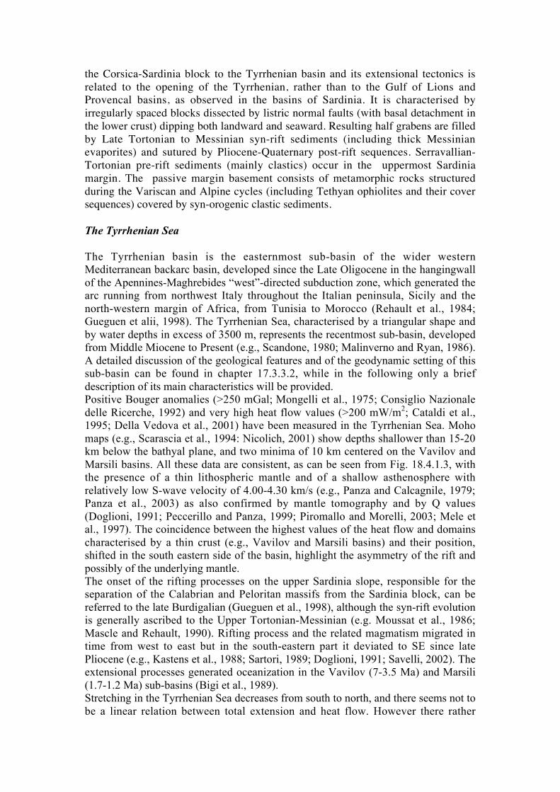
Section parallel to TRANSMED III1. Cells 1 and 2 have thick lithosphere with respect to the next cells: about 170 kmwith the velocity 4.40 km/s - 4.50 km/s.2. The cells from 1 to 4 have higher velocities in the mantle with respect to thefollowing cells and represent the NW continental part of the geotraverse.3. It is clearly visible a low velocity channel under all the Mediterranean from cell 5to cell 17, at depths from ~ 20 km to ~ 140 km.4. In the cell 16 a low velocity hot mantle reservoir is well visible, potentiallyinterpreted as the shallow asthenosphere in the backarc basin, and sourcing theoceanic crust flooring the Tyrrhenian basin.5. There is no evidence for deep hot mantle plume under the Tyrrhenian sea.6. The mantle, consistent with the presence of a continental lithosphere under cells 20,21, and 22, is quite different from that of North Africa, as seen along TRANSMED IIin cells from 11 to 15 (Fig. 18.4.1.2).7. The cell 23 more or less coincides with local maximum of the heat flow (85 kW/m2and more). In this cell, there is a relatively low velocity layer centered at about 100km of depth, very likely a remnant of the Mesozoic rifting.8. Cells from 24 to 27 have a gentle velocity inversion and together with cell 28represent a structure of the mantle consistent with a continental structure, where thelithosphere is quite thick.Seismicity and high velocities correlate quite well in the Apennines and in the Dinaricsubduction zone.

- The Western Mediterranean sub-basins
The geological evolution of the western Mediterranean sub-basins and of theintervening continental swells is described in this section from west to east. The mainfeatures analysed in the following can be recognised in the simplified tectonic map ofFig. 18.4.1.1 and in the two lithospheric scale cross sections of Fig. 18.4.1.4 whichare here only roughly described. For a complete description of TRANSMED II and IIItransects refer to Roca et al. (2004) and Carminati et al. (2004).Along the TRANSMED II section the following main domains are crossed (the regionanalysed in this paper is limited to the central part of this transect):- At its northern end the transect crosses the Aquitaine basin, which is the northernforeland basin of the Pyrenees. More to the south, the Pyrenees, an orogenic beltwhich developed between the late Senonian (Late Cretaceous) and the mid-Oligocenetimes, are crossed together with their southern foreland basin (the Ebro basin).- The section continues through the Catalan Coastal Ranges, an intraplate beltdeveloped during the Paleogene and crosses the Iberian coast, characterised bycontinental lithosphere thinning progressively seaward, as seen from Fig. 18.4.1.2.- The Valencia trough lies on continental lithosphere thinned in the uppermostOligocene-Lower Miocene.- The Valencia trough is bordered to the south by the Balearic Promontory, composedof relatively thicker continental lithosphere interested in the Tertiary by bothcompressional and extensional tectonics.- South of the Balearic islands the Algerian basin, a Miocene basin floored by oceaniccrust, is crossed.- The African portion of the transect crosses -from north to south- the Tell and theSahara Atlas (two fold-and-thrust belts), and ends in the northern part of the Saharanplatform. The Tell developed on top of a southeasterly retreating northwest dippingslab, which became likely detached and therefore is not drawn in the section. Here thelithosphere sits on a very low velocity asthenospheric channel (Fig. 18.4.1.2) , thatseems to be a general feature of the North-Central Pan-African Orogenic block(Hazler et al., 2001).Along the TRANSMED III section the following main domains are crossed:- At its northwestern end the section crosses the French Massif Central, made of thecontinental crust deformed during the Variscan orogeny. The continental lithospherethins towards the French coast where the transect crosses the Gulf of Lions thinnedcontinental margin.- The transect continues in the Provençal Basin, floored by Neogene oceanic crust andthrough the thinned continental lithosphere of the western Sardinia margin.- Eastward, the profile crosses the continental swell of the Corsica-Sardinia block,which was structured during the Variscan and older orogenic cycles, and was laterdissected by Neogene-Quaternary extensional tectonics.- East of Sardinia the lithosphere thins again reaching its minimum thickness in theTyrrhenian Basin, which formed mainly from the Tortonian to the Present. Farthereast the lithosphere gradually thickens and the thinned continental lithosphere of theCampania continental margin is encountered, as seen also in Fig. 18.4.1.3.Although the area of interest for this paper is limited to the described northwesternpart of the TRANSMED III profile, the geotraverse is shown entirely in Fig. 18.4.1.4and the following domains are encountered:

- Continental Italy is mostly constituted by the Southern Apennines, a Neogene fold-and-thrust belt, dissected by Late Neogene-Present extensional tectonics, developed inthe hangingwall of a west-directed subduction zone.- The continental lithosphere of the Adria microplate, thinned during the Mesozoicrifting is crossed in the southern Adriatic Sea. In the eastern southern Adriatic Sea thetransect crosses the foreland basin of the Albanian Dinarides, an orogen associatedwith the north-eastward subduction of the Adriatic lithosphere.- In Albania, Macedonia and Bulgaria, the complex multistage Dinarides-Hellenidesorogen is crossed together with its conjugate retrobelt, i.e., the Balkans. The wholeregion is also affected by Neogene-to-Present extensional tectonics. The transect endsin the Moesian platform, which is the undeformed foreland of the Balkans.Most of the described domains can be readily identified in the S-wave velocity patternof fig. 18.4.1.2 and 18.4.1.3.
Valencia Trough
The Valencia Trough is located between the Iberian mainland and the BalearicIslands, at the southwestern prolongation of the Liguro-Provençal basin and has waterdepths of up to 2200 m. VALSIS and ESCI profiles provide an overall view of thestratigraphy and structure of the basin (Torres et al., 1993; Sàbat et al., 1995). Acomplete description of the Valencia Trough and a synthesis of its evolution isincluded in Roca, 2001 and Roca et al., 2004.The crust of the Valencia Trough is continental. Depth to the Moho decreases fromabout 32 km in the Iberian mainland to 10-15 km along the axis of the ValenciaTrough and increases again towards the Balearic Promontory to 23-25 km (Pascal etal., 1992; Torné et al., 1992; Vidal et al., 1998; Roca, 2001). The minimum thicknessof the crust (along the axis of the Valencia Trough) is about 8 km. Lithosphere is alsothin, depth to lithosphere - asthenosphere boundary ranges from 50 to 80 km (Ayala etal., 2003), and the mantle lithosphere is characterized by an anomalously low seismicvelocity (Pascal et al., 1992), see also Fig. 18.4.1.3.The continental crust of the Valencia trough was structured during the Variscanorogeny and was extended during the Mesozoic rifting phases (Roca, 2001). Theresulting Mesozoic basins were totally or partially inverted during latest Cretaceous-Oligocene as a consequence of the convergence between Iberia and Eurasia(Fernàndez et al. 1995; Roca, 1996; Gaspar-Escribano et al., 2004). This resulted inerosion and in the concomitant development of a major unconformity over the wholearea (Stoeckinger, 1976; Martínez del Olmo, 1996), except in minor syn-compressional basins filled by Eocene to Upper Oligocene terrigenous sediments (i.e.,Barcelona basin; Roca et al., 1999). Overlying this unconformity, four majorpackages have been differentiated in the 2 to 6 km thick València trough basin fill(Clavell and Berástegui 1991; Maillard et al. 1992; Martínez del Olmo 1996; Roca etal. 1999). From bottom to top, these are: (1) syn-rift uppermost Oligocene-LowerMiocene continental deposits and terrigenous outer-shelf marine sediments which arerestricted to grabens and to the deepest parts of the basin; (2) post-rift Middle andUpper Miocene basinward prograding clastic sequences; (3) Messinian salt depositedin the deeper part of the basin coevally with the development of a major down-cuttingunconformity in the shallower part of the basin; (4) Pliocene-Holocene terrigenoussediments deposited in basinward prograding deltas and deep-sea fans.From the Oligocene-Miocene transition to the early Middle Miocene, the ValenciaTrough was characterised by severe extensional tectonics and developed its present
structure.The formation and development of the Valencia Trough were accompaniedby widespread volcanic activity which, as in the case of the Liguro-Provençal basin,was (1) calc-alkaline and related to subduction before the Serravallian, and (2)alkaline with a typical intraplate geochemical signature after the Serravallian (Martí etal., 1992).The upper crustal structure of the Valencia Trough is clearly asymmetric (Fontboté etal. 1990; Sàbat et al., 1995). The Iberian slope (the NW side of the trough) shows athick-skinned extensional structure characterized by NE-SW striking normal faults.Most of these faults dip to the NW, except the major ones, located along thenorthwestern basin margin in the proximity of the coast or onshore (Catalan CoastalRanges), which dip to the SE. These last faults involve partial or total reactivation ofPaleogene thrusts faults which, in turn, reactivate Mesozoic extensional faults(Fontboté, 1954; Roca, 2001). In contrast, the Balearic slope is characterised by thepresence of basement highs, bounded by both normal and thrust faults; thesebasement highs have been interpreted as fault-propagation or fault-bend foldsassociated with SE-dipping thrust faults (Sàbat et al., 1995; Gelabert, 1997).Finally, inversion of extensional structures and development of contractionalstructures resulting from the NW propagation of the Balearic fold-and-thrust beltaffected the Balearic side of Valencia Trough during the Middle and Late Miocene(Sàbat et al., 1995; Roca et al., 2004).
Balearic Promontory
It is located between the Valencia Trough and the Algerian Basin. There is no clearboundary between the Valencia Trough and the Balearic Promontory; its boundarywith the Algerian Basin is outlined by the sharp Emile Baudot Escarpment. BalearicIslands are the emergent areas of the Balearic Promontory. The Balearic Promontory,which forms part of the margin of the Iberian Peninsula, is surrounded by Neogeneextensional basins (Valencia Trough and Algerian Basin) and shows a Neogene basinand range structure. Data are obtained from very good outcrops and seismic lines(most of them off-shore).Crust in the Balearic Promontory reveals a continental character; it is thin (at mostaround 25 km) but thicker than in surrounding areas.The basement is of Variscan type and outcrops extensively in Menorca. Sedimentarycover comprises Mesozoic calcareous sedimentary series similar to those in theCatalan Coastal Ranges and the Iberian Range: Triassic Germanic facies, EarlyJurassic shallow water limestones, Middle and Late Jurassic pelagic marls andlimestones and Cretaceous pelagic marls and shallow water limestones (Rangheard,1984; Bourrouilh, 1983; Alvaro et al., 1989). A stratigraphic gap embraces part of theCretaceous and the Paleogene (Ramos-Guerrero et al., 1989). Paleogene sedimentsare thin and discontinuous on the Balearic Promontory. They are made up of Eoceneshallow water limestones (only present in the southeast) and Oligocene continentalconglomerates and other detritic rocks. Neogene sediments are widespread on thePromontory. They show both syn-orogenic and post-orogenic character. Syn-orogenicNeogene sediments consist of conglomerates, calcareous sandstone, peri-recifallimestones and calcareous turbidites. Post-orogenic Neogene sediments compriserecifal limestones, calcareous sandstone and marls.Only two outcrops of Cenozoic volcanic rocks are known in the Balearic Islands(Martí et al., 1992). They are made up of calc-alkaline volcanic rocks Early Miocene

in age. There is an extensive submarine volcanic field in the SE margin of thePromontory (between Formentera and Cabrera islands) (Acosta et al., 2001).The structure of the Promontory is typical of those existing in the basin and rangeareas:a) Ranges consist of folded and thrusted series where the major detachment is theTriassic Keuper facies (gypsum and lutites). Shortening is high (50%) and increasesto the SE (Gelabert et al., 1992; Gelabert, 1997). In the southeastern areas of theislands of Eivissa and Mallorca, large overturned folds are present. Most of thecontractional features strike NE-SW, but NW-SE structures are also present (Sàbat etal., 1988; Freeman et al.,1989). Deduced overall shortening is NW-SE (Sàbat et al.,1988; Gelabert et al., 1992). In Mallorca, the oldest contractional structures are LateOligocene in age and the youngest are Langhian (Ramos-Guerrero et al., 1989). In theother islands, contractional structures seem to be of similar age, but contractionalstructures in off-shore areas to the NW of the islands are Middle-Late Miocene in age(Sàbat el al., 1995). Contraction shows an overall SE to NW propagation.b) Basins have both an extensional and contractional origin. Although normal faultsare key structural elements of the basins, transversal contractional highs play animportant role. Few normal faults are Oligocene in age but most of them areSerravallian. The oldest sediments are Early or Middle Miocene in some basinsalthough they are Late Miocene in most of the basins.The Balearic Promontory underwent tectonic quiescence during the Paleogene(accompanied by erosion and shallow marine and sub-aerial sedimentation) andduring the Neogene "sensu latu" (Late Oligocene, Early and Middle Miocene)contraction took place (accompanied by sedimentation in shallow marine and talusenvironments). This contraction was followed by the Middle and Late Miocene(mostly Serravallian) extension (Cespedes et al., 2001). Following a period ofquiescence, contraction resumed during the Plio-Quaternary (Gimenez, 2003)(accompanied by shallow marine and sub-aerial sedimentation). Paleomagnetic datasuggest a clockwise rotation of the Balearic Promontory during the Neogene (Parés etal., 1992).The lithosphere, about 30 km thick sits on a very low velocity asthenosphere (Fig.18.4.1.2).
Algerian Basin
This is a deep basin (around 3000 m) located between the Balearic Promontory andthe North Africa margin. The boundary between the Balearic Promontory and theAlgerian Basin is sharp (the Emille Baudot Escarpment). There are few data on theAlgerian Basin; in addition to overall pictures from gravity and magnetic maps, theonly data available are a few seismic refraction data (Hinz, 1973), short segments ofseismic reflection profiles (Sàbat et al., 1995; Mauffret et al., 2004) and severalboreholes - DSDP 124, 371 and 975 (several references in Mauffret et al., 2004).The crust in the Algerian Basin seems to have an oceanic character. In most of thebasin the Moho depth is less then 14 km and the crust is 4 to 6 km thick (Hinz, 1973),being comparable to the oceanic crust (about 5 km thick) of the Liguro-Provençalbasin (Pascal et al. 1993). In the East Alboran basin the heat flow is very high (125mWm-2; Polyak et al. 1996), suggesting a shallow Moho (10 -11.5 km) and a thinlithosphere (45 km) (Torné et al., 2000). A slightly thicker lithosphere (50-60 km) hasbeen proposed (Marillier and Mueller, 1985; Ayala et al., 2003) for the Algerian
basin. In Fig. 18.4.1.2 the lithosphere is not more than 40 km thick and sits on a welldeveloped asthenospheric low velocity channel.The scarcity of deep drilling in the Algerian basin hampers the determination of thecharacteristics and the age of its sedimentary fill. Thus, the stratigraphy must beinferred by correlation from better known areas in the proximity (Mauffret et al. 1973;Sans and Sàbat, 1993). Boreholes only indicate that the Pliocene-Quaternarysedimentary layer is very thin (0.5 km) and that the Messinian evaporites (1.2 kmthick) are highly disturbed by diapirism. Beneath the Messinian evaporites, there is a2-3 km thick non reflective pre-Messinian layer cut by some oil wells close to theAlgerian coast; these wells indicate the presence of Langhian to Tortonian deposits(Cope, 2003).The ESCI seismic profile crosses an area (South of Mallorca) whose sea bottom is flatbut affected by a number of normal faults with small displacements, where Messinianevaporites form spectacular diapirs (Sàbat et al., 1995). Seismic data from the arealocated to the North of the Great Kabylie also reveal normal faults; the displacementsproduced by these faults in the Messinian evaporites are smaller than those producedat the top of the basement (Cope, 2003; Mauffret et al., 2004). According to the maprepresenting the depth to the basement, it has been suggested that these normal faultsstrike NNE-SSW (Mauffret et al., 2004).In addition to the aforementioned faults, very little else is known about the internalstructure of the Algerian Basin. Nevertheless, the three following features should bepointed out: a) The Emille Baudot escarpment, b) the Hannibal Ridge and c) theHamilcar magnetic anomaly.a) The Emille Baudot escarpment (Mauffret et al., 1992) is the surface expression ofthe fault system related to the boundary between the continental crust of the BalearicPromontory and the thin oceanic crust of the Algerian Basin; displacement of thesynthetic faults shows a clear normal component (Sàbat et al., 1995). The EmilleBaudot escarpment strikes NE-SW and at its SW end shows a horse-tail configurationwith individual faults striking ENE-WSW turning to E-W (Acosta et al., 2001).Further W a sharp escarpment reappears, it strikes NE-SW and finally (further W) itruns E-W (Mazarron escarpment). Thus, the overall trace of this prominent faultsystem shows a zigzag geometry. It has been suggested that this fault system, atpresent inactive, had behaved as a right-lateral strike-slip system (Mauffret et al.,1992; Acosta et al., 2001), but no conclusive arguments are available. Moreover, thegeometry described above is more consistent with a NNW-SSE extension (thisextension is sub-parallel to the one in the Valencia Trough).b) The Hannibal ridge is located to the North of the Great Kabylie and is parallel tothe aforementioned NNE-SSW normal faults; it has been suggested that this is a LateMiocene volcanic feature related to E-W extension (Mauffret et al., 2004).c) The Hamilcar magnetic anomaly is located at the boundary between the oceanicareas of the Liguro-Provençal and Algerian basins. It consists of a set of fan shapedanomalies striking NW-SE and converging towards the NW (Galdeano andRossignol, 1977). Its geometry is consistent with a local NE-SW extension (see Fig 5in Gelabert et al., 2002). This extension should be coeval with the formation of theoceanic crust in the Algerian basin and in the Liguro-Provençal Basin. This crust hasbeen dated as Burdigalian in the latter basin.No volcanic rocks have been sampled from the Algerian Basin although they arevisible in the seismic profiles. Nevertheless, volcanism recorded in the North Africanmargin shows that the area was affected by a calc-alkaline volcanic event Aquitanian

to early Serravallian in age. This was followed by alkaline volcanism until the present(Wilson and Bianchini, 1999; Maury et al., 2000; Coulon et al. 2002).The age of the Algerian Basin is unknown but must be much older than the datedMessinian deposits, as these deposits overlie a 2-3 thick km sequence of undatedbasin fill sediments. In this regard, the unloaded depth of the basement gives anapparent age of 20 Ma (Cavazza et al., 2004; Roca et al., 2004) whereas the maximumheat flow of 132 - 125 mWm-2 corresponds to an apparent age of 16 Ma for theyoungest areas in the basin. Tomographic studies (Carminati et al. 1998a) andmagmatic history (Maury et al. 2000) suggest an age ranging between 15 Ma and 10Ma; and, finally, partial restorations of balanced cross-sections point to an ageranging between 25 to 15 Ma (Vergés and Sàbat, 1999) or 20 and 13 Ma (Roca et al.,2004). These last ages agree with the ages deduced from a) the theoretical thickness-age relationships yL=2(kt)1/2 (where yL is the lithospheric thickness, t is the lithosphereage and k is the thermal diffusivity; Turcotte and Schubert, 1982) – assuming k=1mm2 s-1, a thickness of 40 km, as imaged in Fig. 18.4.1.2, yields an age of 12.7 Ma;and b) the suggestion that Algerian and Liguro-Provençal basins are similar in age(21-16 Ma). This suggestion is supported by the fact that these two basins are similarin depth, crustal thickness and layer thickness ratios of the pre-Messinian, Messinianand post-Messinian sediments (Mauffret et al., 2004). Thus, the ages of the two basinsshould be similar but the sedimentation rate in the Algerian basin must be different(much lower) than that in the Liguro-Provençal Basin.
Liguro-Provençal Basin
This basin comprises the present day Ligurian Sea, the Gulf of Lions as well as theportion of the Mediterranean Sea located West of Corsica and Sardinia, and East ofMenorca. It is the oldest Western Mediterranean basin and today has a maximumwater depth of 2800 m. The ECORS-CROP seismic section provides an overall viewof the stratigraphy and structure of the basin (De Voogd et al., 1991). A description ofthe Liguro-Provençal basin and a synthesis of its evolution is included in Roca(2001).The lithosphere beneath the Liguro-Provençal basin is thin (minimum depth to thelithosphere-asthenosphere boundary is less than 30 km, as shown in Fig. 18.4.1.3) andseismic and gravity data show that the crust decreases in thickness from about 32 kmbeneath the Eurasian mainland and the Corsica-Sardinia Block to about 5 km beneaththe central part of the basin where it is oceanic (Pascal et al., 1993; Chamot-Rooke etal., 1997). This oceanic crust occupies the central part of the basin and delineates a150 km wide string oriented NE-SW bounded by a broad transitional crust. Theoceanic crust in the Liguro-Provençal basin has been dated as late Aquitanian to lateBurdigalian-early Serravallian on the basis of heat flow, tristanite in samples,paleomagnetism and subsidence analyses (Vigliotti and Langenheim, 1995).The Liguro-Provençal basin fill comprises a fairly complete succession of lower orupper Oligocene to Holocene deposits that can be subdivided into syn-rift and post-rift series (Gorini et al., 1993). The syn-rift series, Late Eocene to Aquitanian in age,are restricted to grabens and to the deepest parts of the basin, and are made up ofcoarse grained alluvial to lacustrine successions which grade laterally into marinedeposits. Post-rift series form the bulk of the sedimentary fill of the Liguro-Provençalbasin and are late Aquitanian to Holocene in age. They consist of marine depositsmainly sedimented in terrigenous shelf, delta and deep sea fan environments. Therapid Messinian drop in the level of the Mediterranean sea is recorded by the

development of a major down-cutting unconformity in the shallower parts of the basinand by the accumulation of thick evaporites in its deeper part.The formation and development of the Liguro-Provençal basin were accompanied bywidespread magmatic activity with volcanic centres located both offshore (i.e.,Ligurian Sea) and onshore (south France, Corsica and Sardinia islands). Thegeochemical signature of these volcanic rocks clearly shows a magmatic evolutionwith two-well differentiated cycles (Roca, 2001): the first cycle, Late Oligocene-earlySerravallian in age, is calc-alkaline and mainly located along the Corsica-SardiniaBlock, Ligurian Sea and neighbouring southern Alps. The second one is alkaline,spans from Tortonian to Holocene times and affects the entire basin with extrusivecentres clustered onshore in the Languedoc-Montaigne Noire (southern France) andSardinia.The structure of the Liguro-Provençal basin reflects its extensional origin. It consistsof 1) a broad northwestern extensional margin with ENE-oriented grabens and horstsmainly bounded by SE-dipping faults; the detachment of the faults is shallow andlocated in the Triassic evaporites to the NW and ramps down seawards into thebasement where it gives way to a thick-skinned extensional system; 2) a central andflat oceanic part with Pliocene diapirs cored by Messinian salt; and finally 3) thenarrow and abrupt Corsica-Sardinia margin whose internal structure is not clear(Gorini et al., 1993; Séranne et al., 1995; Roca, 2001).Rifting in the Provençal-Ligurian basin started during latest Eocene-Early Oligocene(34-28 Ma) and ended in the middle Aquitanian (21 Ma) (Séranne, 1999).Subsequently, the central oceanic portion of the basin was generated between the lateAquitanian and late Burdigalian (21-16 Ma) associated with the counter clockwiserotation of the Corsica-Sardinia Block (Vigliotti and Langenheim, 1995; Speranza etal., 2002). Before drifting, this block of the Iberian plate was located close to theProvençal coast and the present-day, Gulf of Lions.The Liguro-Provençal Basin is considered to be a back-arc basin generated from thesoutheastward roll-back of the Apennines-Maghrebides subduction (Rehault et al.,1984; Doglioni et al., 1997).
The Corsica-Sardinia block
The Sardinia block is characterized by a crust about 20 km thick that is getting thickeras we move towards East; on the West (Sardinia trough) the lid is thin but fast.Therefore, the lithosphere reaches about 40 km on the West side, while is it about 70km thick on the East (Fig. 18.4.1.3).In Sardinia abundant traces of Paleozoic tectonics (both compressional andextensional) ascribed to the Variscan cycle and of late Paleozoic magmatism arerecognised (Carmignani et al., 1994). The Variscan tectono-metamorphic edifice ofSardinia is composed by several tectonic units. Their emplacement time ranges fromDevonian to Carboniferous (Carmignani et al. 1994) and the direction of transportvaried through time from top to the south to top to the west (Conti et al. 2001). In alater stage, N-S shortening resumed. The Variscan Belt was dissected by normalfaults pertaining to the late Variscan stages, which were accompanied by lateCarboniferous igneous activity and by LP/HT metamorphism.During the Permo-Triassic Sardinia experienced continental rifting and, during theJurassic, it was located along the western margin of the Alpine Tethys. Being until theOligocene attached to the Iberian plate, the Oligocene-Aquitanian NE-SW trendingnormal faults, that dissected previously deformed areas of the Pyrenees and of the
Iberian chain in the Camargue and Gulf of Lions rifts, affected also Sardinia. Thesefaults cut through pre-Alpine basement in the Sardinia rift (Burrus 1989). The rift isbounded by west and east dipping normal faults and it is filled by up to 2 km of syn-and post-rift deposits, as constrained by seismic lines (Casula et al. 2001). Syn-riftUpper Oligocene deposits mainly consist of non-marine sediments followed byfluvial-deltaic sediments, marls and silts. Post-rift sediments are Burdigalian marinemarls-siltstones. Marine sedimentation continued until the Messinian regression(accompanied by an erosional stage). Pliocene-to-recent sedimentation was mainlylocalised in the Campidano graben (SW Sardinia).Corsica can be divided in two distinct geological domains (Durand Delga, 1978). Thewestern two thirds of the island (Variscan Corsica) consist mainly of a large lateVariscan (Carboniferous to Permian; 340-260 Ma Cocherie et al., 1984) granitebatholith, which intruded Precambrian and Palaeozoic country rocks. Scatteredportions of this Variscan metamorphic basement crop out within the lateCarboniferous granitoids. These metamorphic outcrops are characterized by poly-metamorphic histories (Menot and Orsini,1990), and different metamorphic grade(from granulite and eclogite to anchizonal facies (Lardeaux et al., 1990; Thevoux-Chabuel et al., 1995). The Variscan basement is cut by major late Variscan left-lateralstrike-slip faults mainly oriented NE-SW.The northeastern part of Corsica (Alpine Corsica) consists of a complex stack ofunmetamorphosed to eclogite facies (Brunet et al., 2000; Malavieille et al., 1998)tectonic units of Alpine age of both oceanic and continental origin, interpreted as thesouthern continuation of the Penninic domain of the Western Alps. The AlpineCorsica units were thrust westward onto the Variscan basement of western Corsica(Durand Delga, 1978; Mattauer et al., 1981). The oceanic rocks are interpreted asremnants of the Liguro–Piemontese ocean, a portion of the western Tethys oceanwhich was located between the European and Adriatic continental margins and wassubducted since the Cretaceous. The subduction process was accompanied by top-to-the-west thrusting and development of HP/LT metamorphism (Mattauer et al., 1981)and was followed by continental collision and underthrusting of continental crustduring Early Tertiary time.During the Oligocene, the sense of shear reversed and widesperead top-to-the-eastextension dissected the previous Alpine edifice (Daniel et al., 1996; Jolivet et al.,1990). Early Miocene rapid denudation and cooling accompanied the extensionalcollapse of the Alpine belt (Brunet et al., 2000; Cavazza et al., 2001).Extensional tectonics led to the formation of strongly subsiding basins (e.g., SaintFlorent and Aleria basins), filled with up to 2 km sediments deposited since theBurdigalian (Ferrandini et al., 1996) and continuous with the offshore Corsica basin.Late Oligocene-early Serravallian calc-alkaline volcanism is widespread along theCorsica-Sardinia Block (Savelli 1988; Beccaluva et al. 1989). A later phase ofvolcanism started in Tortonian-Messinian times and is of alkaline affinity.The present day position of the Corsica-Sardinia block is the result of the abovementioned Oligocene-Aquitanian rifting phase. These extensional tectonics began toseparate Corsica and Sardinia from the Iberia peninsula. The subsequent oceanizationof the Provençal Basin was accompanied by an anticlockwise rotation of the Corsica-Sardinia block during Early Miocene (Vigliotti and Langenheim 1995; Speranza et al.2002). Such a rotation determined the displacement of the Variscan Belt cropping outin Sardinia from its counterpart cropping out in Iberia and in the French MassifCentral.The wide eastern Sardinia and Corsica continental margin marks the transition from
the Corsica-Sardinia block to the Tyrrhenian basin and its extensional tectonics isrelated to the opening of the Tyrrhenian, rather than to the Gulf of Lions andProvencal basins, as observed in the basins of Sardinia. It is characterised byirregularly spaced blocks dissected by listric normal faults (with basal detachment inthe lower crust) dipping both landward and seaward. Resulting half grabens are filledby Late Tortonian to Messinian syn-rift sediments (including thick Messinianevaporites) and sutured by Pliocene-Quaternary post-rift sequences. Serravallian-Tortonian pre-rift sediments (mainly clastics) occur in the uppermost Sardiniamargin. The passive margin basement consists of metamorphic rocks structuredduring the Variscan and Alpine cycles (including Tethyan ophiolites and their coversequences) covered by syn-orogenic clastic sediments.
The Tyrrhenian Sea
The Tyrrhenian basin is the easternmost sub-basin of the wider westernMediterranean backarc basin, developed since the Late Oligocene in the hangingwallof the Apennines-Maghrebides “west”-directed subduction zone, which generated thearc running from northwest Italy throughout the Italian peninsula, Sicily and thenorth-western margin of Africa, from Tunisia to Morocco (Rehault et al., 1984;Gueguen et alii, 1998). The Tyrrhenian Sea, characterised by a triangular shape andby water depths in excess of 3500 m, represents the recentmost sub-basin, developedfrom Middle Miocene to Present (e.g., Scandone, 1980; Malinverno and Ryan, 1986).A detailed discussion of the geological features and of the geodynamic setting of thissub-basin can be found in chapter 17.3.3.2, while in the following only a briefdescription of its main characteristics will be provided.Positive Bouger anomalies (>250 mGal; Mongelli et al., 1975; Consiglio Nazionaledelle Ricerche, 1992) and very high heat flow values (>200 mW/m2; Cataldi et al.,1995; Della Vedova et al., 2001) have been measured in the Tyrrhenian Sea. Mohomaps (e.g., Scarascia et al., 1994: Nicolich, 2001) show depths shallower than 15-20km below the bathyal plane, and two minima of 10 km centered on the Vavilov andMarsili basins. All these data are consistent, as can be seen from Fig. 18.4.1.3, withthe presence of a thin lithospheric mantle and of a shallow asthenosphere withrelatively low S-wave velocity of 4.00-4.30 km/s (e.g., Panza and Calcagnile, 1979;Panza et al., 2003) as also confirmed by mantle tomography and by Q values(Doglioni, 1991; Peccerillo and Panza, 1999; Piromallo and Morelli, 2003; Mele etal., 1997). The coincidence between the highest values of the heat flow and domainscharacterised by a thin crust (e.g., Vavilov and Marsili basins) and their position,shifted in the south eastern side of the basin, highlight the asymmetry of the rift andpossibly of the underlying mantle.The onset of the rifting processes on the upper Sardinia slope, responsible for theseparation of the Calabrian and Peloritan massifs from the Sardinia block, can bereferred to the late Burdigalian (Gueguen et al., 1998), although the syn-rift evolutionis generally ascribed to the Upper Tortonian-Messinian (e.g. Moussat et al., 1986;Mascle and Rehault, 1990). Rifting process and the related magmatism migrated intime from west to east but in the south-eastern part it deviated to SE since latePliocene (e.g., Kastens et al., 1988; Sartori, 1989; Doglioni, 1991; Savelli, 2002). Theextensional processes generated oceanization in the Vavilov (7-3.5 Ma) and Marsili(1.7-1.2 Ma) sub-basins (Bigi et al., 1989).Stretching in the Tyrrhenian Sea decreases from south to north, and there seems not tobe a linear relation between total extension and heat flow. However there rather

appears an evident correlation between active magmatism and heat flow.The Italian and Sardinia-Corsica continental margins are dissected by mainly listric(dipping both basinward and landward) normal faults rooted in the lower crust.The listric faults disappear across the oceanized sectors. In the Vavilov Basin 4 Maold MORB basalts were drilled by ODP Site 655 below the Pliocene-Quaternarysequence (Beccaluva et al. 1990; Serri et al. 2001). Moreover, a section of sub-crustalfoliated and serpentinized upper mantle occurs in the eastern Vavilov Basin, as shownby ODP Site 651 drillings (Kastens et al. 1987; Bonatti et al. 1990). The peridotitesare capped by 2.6 Ma old pillow lavas.The bottom of the Tyrrhenian basin is expected to be floored with remnants of theVariscan and Alpine belts dissected by the Tertiary extensional tectonics. Forexample, along the steep escarpment of the Flavio Gioia Seamount, Variscanbasement rocks, tectonically associated with Mesozoic-Tertiary sedimentary rocks(likely involved in the Calabride-Kabylide fold-and-thrust belt), were dredged (DalPiaz et al. 1983; Sartori 1986).
- Geodynamic evolution of the Western Mediterranean area
Restoring the Corsica-Sardinia block to its Middle Eocene (45 Ma; Fig. 18.4.1.5)position prior to rotation, the Alps were probably linked to the Betics through AlpineCorsica and the Balearic promontory to form a double vergent belt (Doglioni et al.1999). The development of the Alpine-Betic chain is related to a south-eastwardsubduction occurring at that time in the Tethyan area, as testified by HP mineralassemblages known in the Alps, in Corsica, in the Alboran domain and possibly in theKabylies domain. The Alpine chain development was synchronous to the Pyreneesshortening (that continue until ~24.7 Ma according to a magnetostratigraphic study;Meigs et al. 1996) resulting from the complete inversion of a basin interveningbetween Iberia and Eurasia.Some 30 Ma ago (Fig. 18.4.1.6), the west directed Apennines-Maghrebidessubduction started. As proposed by Doglioni et al. (1999), it possibly nucleated alongthe Alps-Betics retrobelt and was possibly triggered by the occurrence, in the forelandeast of the Alpine belt, of oceanic or thinned continental lithosphere. Following thesame authors, a period of contemporaneity between Alpine and Apenninessubductions possibly occurred from Late Oligocene to Early Miocene.The Apennines-Maghrebides subduction zone experienced a fast radial (towards thenorth-east, south-east and the south) rollback, testified to by the migration of thesubduction related calkalcaline volcanism. The rollback of the subduction hingedetermined the onset of widespread extensional tectonics in the backarc (in the Gulfof Lions and Provençal Basin, in the Catalan Coastal Ranges area, in Sardinia, stillattached to Iberia, in the Valencia trough and in the Algerian Basin). Regionalthinning was accompanied by alkaline volcanism and, in the Provençal and in theAlgerian Basins, continental crust stretching evolved into oceanization. In summary:the Valencia Trough, together with the Liguro-Provençal basin, records the onset ofthe southeastward roll-back of the Apennines-Maghrebides subduction, whichgenerated the opening of both basins as back-arc basins and the coeval developmentof the Balearic fold-and-thrust belt (Doglioni et al., 1997; Vergés and Sàbat, 1999;Roca, 2001). The active extension and oceanization in the Liguro-Provençal basin iscoeval with the counterclockwise rotation of the Corsica-Sardinia block.The geodynamic origin of the Algerian basin is less constrained. It has been related tothe roll-back of the Apennines-Maghrebides subduction, but as regards the direction

of this roll-back, two different kinematic scenarios have been proposed: 1) south tosoutheastward retreat of the subduction generating a NNW-SSE extension; in thiscase, Kabylies must have moved away from the Balearic Promontory (Verges andSàbat, 1999; Roca et al., 2004), 2) westwards retreat of the subduction resulting in aENE-WSW extension; in this case, the Alboran block was originally located as far asthe present location of the Algerian Basin and must have moved a considerabledistance to its present position (Martinez-Martinez and Azañon, 1997; Platt et al.,2003; Mauffret et al., 2004; Spakman and Wortel, 2004). Most of the data supportingthese two hypotheses are derived from the areas around the Algerian Basin and veryfew come from the basin itself. In the Mediterranean Sea, which has beencomprehensively studied, there are still blank areas on the map, and the AlgerianBasin is one of these. The first hypothesis is here preferred, i.e. between 20 and 15Ma a NNW-SSE large extension associated with SSE roll-back of the Maghrebidessubduction led to the opening of the Algerian Basin.The part of the Alps-Betics orogen which was located in the area of the Apennines-Maghrebides backarc basin was disarticulated and spread-out into the westernMediterranean (e.g., the metamorphic slices of Kabylie in N-Algeria, and Calabria inS-Italy).The Apennines and Maghrebides fold-and-thrust belt developed on top of theretreating subduction and the deformation front migrated to the east in the Apenninesand to the South in the Maghrebides, following the slab roll-back (Malinverno andRyan 1986; Patacca et al. 1990; Doglioni 1991). The Balearic Promontoryexperienced NW-SE contraction coevally with the NW-SE extension in the ValenciaTrough and probably also with the extension in the Algerian Basin (Vergés and Sàbat,1999). The Balearic Promontory resembles an extensional crustral boudin, butunderwent coeval (and syntaxial) horizontal shortening.A shift of active extension from west to east of Sardinia occurred in the Langhian (ca.15 Ma; Fig. 18.4.1.7) and produced the Middle Miocene to Present opening of theTyrrhenian Basin. At the same time, a major tectonic and magmatic reorganizationoccurred along the northern African margin (Carminati et al., 1998a). The continentalcollision between the Kabylies and north Africa led to the end of the oceanicaccretion in the Algerian Basin. Subsequently, compressive stresses built-up in thewhole area, inducing compressive and transpressive reactivation of previous faults(Vergés and Sàbat 1999; Frizon de Lamotte et al. 2000). It has been proposed thatcontinental collision was followed by slab breakoff and consequent lithospheredetachment along the northern African margin (Carminati et al., 1998a). Theoccurrence of a slab detachment process is supported by tomographic models showingan interruption in the slab subducting beneath northern Africa, by the S-wave velocitymodel of Fig. 18.4.1.2 that shows no evidence for a subducting slab, by theoccurrence of bimodal volcanism and by uplift of the African margin (Carminati etal., 1998a; Coulon et al., 2002; Roca et al., 2004). The breakoff possibly begun inCentral Eastern Algeria and subsequently propagated eastwards and westwards(Maury et al., 2000; Coulon et al. 2002). The contractional scenario following thecontinental collision continues to the present and the convergence between theEuropean and African plates is mainly accommodated along the southern margin ofthe Algerian Basin (Vannucci et al., 2004), where several ENE-WSW-trendingreverse faults such as the fault responsible for the 2003 Boumerdès earthquake areactive. This could suggest that a new north-verging accretionary prism will formalong the African margin (Roca et al., 2004).Several explanations for the Langhian eastward jump of extension from west to east

of the Corsica-Sarinia blocks have been proposed. In a first model (Gueguen et al.,1997) it is emphasized that the western Mediterranean backarc setting is comparablewith Atlantic and western Pacific backarc basins that show similar large-scalelithospheric boudinage, where parts of earlier orogens have been scattered in thebackarc area, like the Central America Cordillera relicts that are dispersed in theCaribbean domain. In other words, boudinage is a natural feature in backarc basins(Doglioni et al., 1999) and therefore no major geodynamic, kinematic or tectonicchanges are to be sought to explain such structures.In a second model, the shift of extension is genetically linked to the detachment of theMaghrebian portion of the retreating Apennines-Maghrebides slab (Carminati et al.,1998a, 1998b). According to this interpretation the detachment of part of the slabcaused a change in the rollback geometry from radial to eastward directed. Thishypothesis is supported by the contemporaneity of the two processes and by theresults of numerical models showing that the suggested slab detachment could havedriven to a major stress change in the western mediterranean area.A further model suggests that the eastward jump of extension was induced by theinteraction between the subducting slab and the 660 km discontinuity which cameinto contact in the Langhian (Faccenna et al., 2001). This contact possibly brought toa sudden decrease of the subduction rate and trench migration between 16 and 10 Maago and to an eastward jump of extension when fast slab retreat resumed.Whatever the cause of the shift of extension, the continued rollback of the Apenninesslab brought to the formation of the Tyrrhenian basin from the Langhian to thePresent (Fig. 18.4.1.8).The Tyrrhenian architecture and magmatism seem to be directly correlated to thecomposition, thickness, and the subduction rate of the downgoing subductinglithosphere beneath the Apennines (i.e., continental in the Adriatic and oceanic in theIonian). Since the volume left by the slab retreat is necessarily filled by the uppermantle, the slab rollback of the Apennines subduction kinematically requires aneastward mantle flow in the Tyrrhenian area (and in western Mediterranean ingeneral), as also revealed by shear wave splitting (Margheriti et al., 2003).Regardless this mantle flow is the cause or a consequence of the slab rollback, it canaccount for the progressive eastward rejuvenation and boudinage of the westernMediterranean basins, e.g., from the Provençal to the Tyrrhenian (Gueguen et al.,1997).The boudins and necks are also asymmetric: the base of the crust and of thelithosphere is in fact shifted several tens of km eastward relative to the topography ofthe basins and swells (Cella et al., 1998), coherently with a shear between lithosphereand underlying mantle (see also Fig. 18.4.1.3).Finally, it is worthwhile to emphasize that, paradoxically, the extension affectingmost of the western Mediterranean developed in a context of relative convergencebetween Africa and Europe. However that the maximum amount of North-SouthAfrica/Europe relative motion in the last 23 Ma was about 135 km at the Tunisialongitude, more than five times smaller than the eastward migration of the Apenninesarc, which moved eastward more than 700 km during the same time span (Fig. Fig.18.4.1.6-18.4.1.8). Therefore the eastward migration of the Apennines-Maghrebidesarc cannot be considered as a consequence of the relative N-S relative convergencebetween Africa and Europe, but it is rather a consequence of the Apennines-Maghrebides subduction rollback.

Figure 18.4.1.1 - Simplified tectonic map of the western Mediterranean.

Figure18.4.1.2 - Lithosphere-astenosphere system for geotraverse II: upper part - location ofthe studied profile; lower part - the cross section obtained from selected solutions andrelated seismicity (body waves magnitude greater or equal to 3.0). The chosen shearvelocity and its range of variability in km/s is printed on each layer. The rectanglesoutline the range of variability of the layers thicknesses. The velocity of the crustallayers is denoted by white numbers. The hypocenters are denoted by dots.
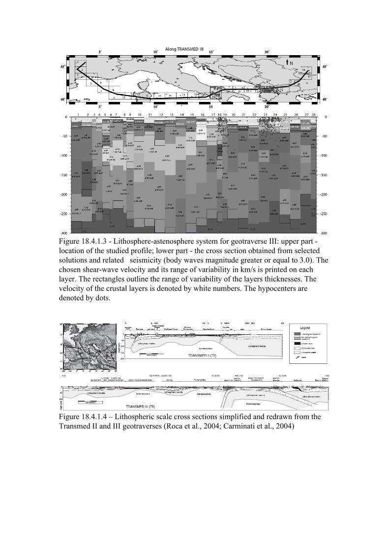
Figure 18.4.1.3 - Lithosphere-astenosphere system for geotraverse III: upper part -location of the studied profile; lower part - the cross section obtained from selectedsolutions and related seismicity (body waves magnitude greater or equal to 3.0). Thechosen shear-wave velocity and its range of variability in km/s is printed on eachlayer. The rectangles outline the range of variability of the layers thicknesses. Thevelocity of the crustal layers is denoted by white numbers. The hypocenters aredenoted by dots.
Figure 18.4.1.4 – Lithospheric scale cross sections simplified and redrawn from theTransmed II and III geotraverses (Roca et al., 2004; Carminati et al., 2004)
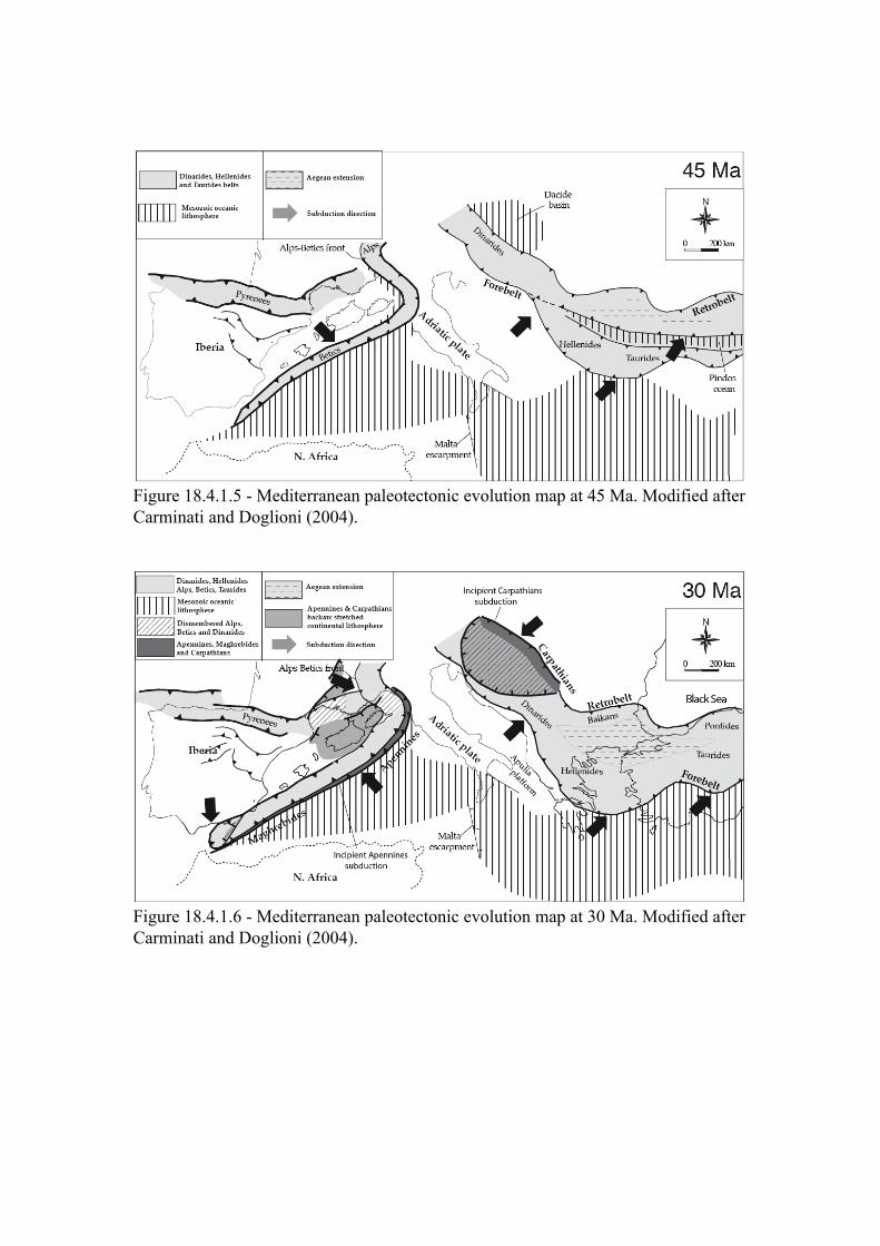
Figure 18.4.1.5 - Mediterranean paleotectonic evolution map at 45 Ma. Modified afterCarminati and Doglioni (2004).
Figure 18.4.1.6 - Mediterranean paleotectonic evolution map at 30 Ma. Modified afterCarminati and Doglioni (2004).
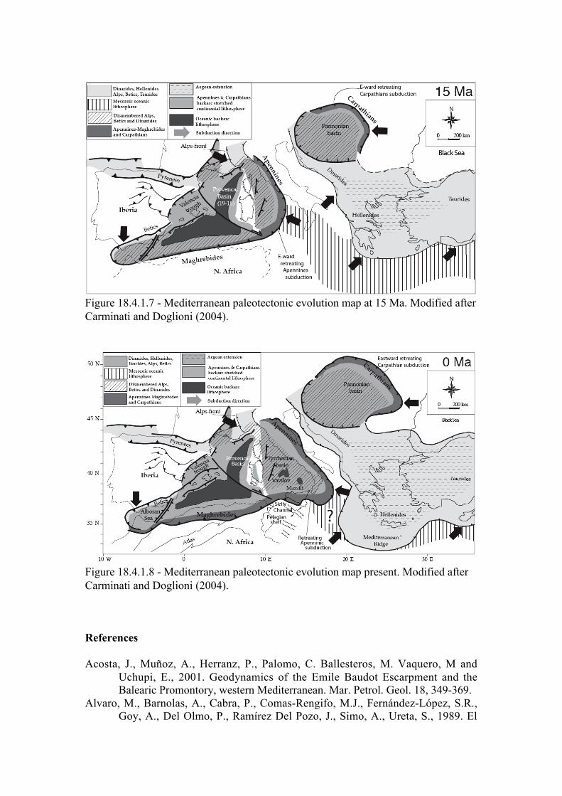
Figure 18.4.1.7 - Mediterranean paleotectonic evolution map at 15 Ma. Modified afterCarminati and Doglioni (2004).
Figure 18.4.1.8 - Mediterranean paleotectonic evolution map present. Modified afterCarminati and Doglioni (2004).
References
Acosta, J., Muñoz, A., Herranz, P., Palomo, C. Ballesteros, M. Vaquero, M andUchupi, E., 2001. Geodynamics of the Emile Baudot Escarpment and theBalearic Promontory, western Mediterranean. Mar. Petrol. Geol. 18, 349-369.
Alvaro, M., Barnolas, A., Cabra, P., Comas-Rengifo, M.J., Fernández-López, S.R.,Goy, A., Del Olmo, P., Ramírez Del Pozo, J., Simo, A., Ureta, S., 1989. El
Jurásico de Mallorca (Islas Baleares). Cuadernos de Geología Ibérica, 13, 67-120.
Ayala, C., Torné, M. and Pous, J., 2003. The lithosphere-astenosphere boundary inthe western Mediterranean from 3D joint gravity and geoid modeling: tectonicimplications. Earth Plan Science Letters 209, 275-290.
Beccaluva, L., Brotzu, P., Macciotta, G., Morbidelli, L., Serri, G., Traversa, G., 1989.Cainozoic tectono-magmatic evolution and inferred mantle sources in theSardo-Tyrrhenian area. In: The lithosphere in Italy. Advances in Earth ScienceResearch, Boriani, A., Bonafede, M., Piccardo, G.B., Vai, G.B., (Eds.). Attidei Convegni Lincei 80, 229-248.
Beccaluva, L., Bonatti, E., Dupuy, C., Ferrara, G., Innocenti, F., Lucchini, F., Macera,P., Petrini, R., Rossi, P. L., Serri, G., Seyler, M. and Siena, F., 1990.Geochemistry and mineralogy of volcanic rocks from ODP sites 650, 651,655, and 654 in the Tyrrhenian Sea. In: N.J. Stewart (Ed.), Procedings of theOcean Drilling Program, Scientific Results. U.S. Gov. Print. Off., Washington,D.C., 107, 49-74.
Bigi, G., Castellarin, A., Catalano, R., Coli, M., Cosentino, D., Dal Piaz, G.V.,Lentini, F., Parotto, M., Patacca, E., Praturlon, A., Salvini, F., Sartori, R.,Scandone, P. and Vai, G.B., 1989. Synthetic structural-kinematic map of Italy,scale 1:2.000.000. CNR, Progetto Finalizzato Geodinamica, Roma.
Bonatti, E., Seyler, M., Channell, J., Girardeau, J., Mascle, G., 1990. Peridotitesdrilled from the Tyrrhenian Sea, ODP Leg 107. In: Kastens K.A., Mascle J., etal. (Eds.). Proceedings of the ODP, Scientific Results 107: 37-48.
Bourrouilh, R., 1983. Estratigrafia, sedimentologia y tectonica de la isla de Menorca ydel Noroeste de Mallorca (Baleares). Memorias del IGME, 99, Madrid, 672pp.
Brunet, C., Monié, P., Jolivet, L. and Cadet J.-P., 2000. Migration of compression andextension in the Tyrrhenian Sea, insights from 40Ar/39Ar ages on micas alonga transect from Corsica to Tuscany, Tectonophysics, 321, 127-155.
Burrus, J., 1989. Review of geodynamic models for extensional basins; the paradox ofstretching in the Gulf of Lions (Northwest Mediterranean). Bull. Soc. Geol..Fr., V, 377-393.
Carmignani L, Carosi R, Di Pisa A, Gattiglio M, Musumeci G, Oggiano G, PertusatiP.C., 1994. The Hercynian chain in Sardinia (Italy). Geodinamica Acta, 7, 31-47.
Carminati, E., and Doglioni, C., 2004. Europe - Mediterranean tectonics. InEncyclopedia of Geology, Elsevier, 135-146.
Carminati, E., Doglioni, C. and the TRANSMED III working group, 2004.TRANSMED – TRANSECT III: a description of the section and of the datasources. In: W. Cavazza, F. Roure, W. Spakman, G.M. Stampfli and P.A.Ziegler (eds). The TRANSMED Atlas- The Mediterranean Region from Crustto Mantle. Springer, Berlin Heidelberg.
Carminati, E., Wortel, M.J.R., Spakman, W., Sabadini, R., 1998a. The role of slabdetachment processes in the opening of the western–central Mediterraneanbasins: some geological and geophysical evidence. Earth Planet. Sci. Lett.,160, 651-665.
Carminati, E., Wortel, M.J.R., Meijer, P.T. and Sabadini, R., 1998b. The two stageopening of the western-central Mediterranean basins: a forward modeling testto a new evolutionary model. Earth Planet. Sci. Lett. 160, 667-679.

Casula, G., Cherchi, A., Montadert, L., Murru, M., Sarria, E., 2001. The Cenozoicgraben system of Sardinia (Italy): geodynamicevolution from new seismic andfield data. Mar. Petr. Geol., 18, 863-888.
Cataldi, R., Mongelli, F., Squarci, P., Taffi, L., Zito, G., and Calore, C., 1995.Geothermal ranking of the italian territory, Geothermics, 24, 115 – 129.
Cavazza W., Roure, F. and Ziegler, P., 2004. The Mediterranean Area and theSurrounding Regions: Active Processes, Remnants of Former Tethyan Oceansand Related Thrust Belts. In: W. Cavazza, F. Roure, W. Spakman, G.M.Stampfli and P Ziegler (Eds), The TRANSMED Atlas. p. 1-29.
Cavazza, W., Zattin, M., Ventura, B. and Zuffa G.G., 2001. Apatite fission-trackanalysis of Neogene exhumation in northern Corsica (France), Terra Nova, 13,51-57.
Cella, F., Fedi, M., Florio, G. and Rapolla, A., 1998. Optimal gravity modelling of thelitho-asthenosphere system in Central Mediterranean. Tectonophysics, 287: 1-4, 117-138.
Céspedes, A., Giménez, J., Sàbat, F., 2001. Caracterizacióndel campo de esfuerzosneógenos en Mallorca mediante el análisis de poblaciones de fallas.Geogaceta, 30, 199-202.
Chamot-Rooke, N., Jestin, F. and Gaulier, J.M. 1997. Constraints on Moho depth andcrustal thickness in the Liguro-Provençal Basin from a 3D gravity inversion:geodynamic implications. Revue de l’Institut Français du Pétrole, 52, 557-583.
Clavell, E. and Berastegui, X., 1991. Petroleum geology of the Gulf of Valencia. In:A.M. Spencer (ed), Generation, Accumulation and Production of Europe'sHydrocarbons. Osford University Press, Oxford, 355-368.
Cocherie, A., Rossi, P., and Le Bel, L., 1984. The Variscan calc-alkalic plutonism ofWestern Corsica: Mineralogy and major and trace element geochemistry,Phys. Earth Planet. Inter., 35, 145-178.
Consiglio Nazionale delle Ricerche, 1992. Structural model of Italy and gravity map,scale 1:500,000, Progetto Finalizzato Geodin, vol. 3, Quad. Ric. Sci., 114.
Conti P., Carmignani L., Funedda A., 2001. Change of nappe transport directionduring the Variscan collisional evolution of central-southern Sardinia (Italy).Tectonophysics, 332, 255-273.
Cope, M.J., 2003. Algerian licensing round may offer opportunity for explorationplays in deep offshore frontier. First break 21, 35-40.
Coulon, C., Megartsi, M., Fourcade, S., Maury, R., Bellon, H., Louni-Hacini, A.,Cotton, J., Coutelle, A. and Hermitte, D., 2002. Post-collisional transitionfrom calc-alkaline to alkaline volcanism during the Noegene in Oranie(Algeria): magmatic expression of a slab breakoff. Lithos 62, 87-110.
Crespo-Blanc, A., 1995. Interference pattern of extensional fault systems: a case studyof the Miocene rifting of the Alboran basemeent (North of Sierra Nevada,Betic Chain). Jour. Struct. Geol., 17 (11), 1559-1569.
Dal Piaz, G.V., Del Moro, A., Di Sabatino, B., Sartori, R., Savelli, C., 1983. Geologiadel Monte Flavio Gioia (Tirreno centrale). Mem. Sci. Geol. Padova, 35, 429-452.
Daniel, J. M., Jolivet, L., Goffé, B., and Poinssot, C., 1996. Crustal-scale strainpartitioning: Footwall deformation below the Alpine Oligo-Miocene
detachment of Corsica, J. Struct. Geol., 18, 41-59.Della Vedova, B., Bellani, S., Pellis, G. and Squarci, P., 2001. Deep temperatures and
surface heat flow distribution. In: Vai G.B. and Martini L.P. (Ed.), “Anatomy

of an orogen: the Apennines and adjacent Mediterranean basins”. KluwerAcademic Publishers, 65-76.
De Voogd, B., Nicolich, R., Olivet, J.L., Fanucci, F., Burrus, J., Mauffret, A., Pascal,G., Argnani, A., Auzende,J.M., Bernabini, M., Bois, C., Carmingani, L., Fabri,A., Finetti, I., Galdeano, A. Gorini, C.Y., Labaume, P., Lajat, D., Patriat, P.,Pinet, B., Ravat, J., Ricci Lucchi, F., and Vernassa, S., 1991. First deepseismic reflection transect from the gulf of Lions to Sardinia (ECORS-CROPprofiles in western Mediterranean). In: American Geophysical Union (ed),Continental lithosphere: deep seismic reflections. Geodynamics 22, 265-274.
Ditmar, P., T. Yanovskaya, 1987. An extension of the Backus-Gilbert technique forestimating lateral variations of surface wave velocities, Izv., Physics of theSolid Earth, 6, 30-60 (in Russian).
Doglioni, C., 1991. A proposal of kinematic modelling for W-dipping subductions -Possible applications to the Tyrrhenian-Apennines system. Terra Nova, 3:423-434.
Doglioni, C., Gueguen, E., Sàbat, F. and Fernandez, M., 1997. The WesternMediterranean extensional basins and the alpine orogen. Terra Nova 9 (3),109-112.
Doglioni, C., Harabaglia, P., Merlini, S., Mongelli, F., Peccerillo, A., Piromallo, C.,1999. Orogens and slabs vs their direction of subduction. Earth ScienceReviews, 45, 167-208.
Doglioni, C., Mongelli, F., Pialli, G.P., 1998. Boudinage of the Alpine belt in theApenninic back-arc. Mem. Soc. Geol. It., 52, 457-468.
Durand Delga, M., (Ed.), 1978. Corse. Guide Géologique Régional, 208 pp., Masson,Paris.
Dziewonski, A., S. Bloch, N. Landisman, 1969. A technique for the analysis oftransient seismic signals, Bull. Seism. Soc. Am., 59, 427-444.
Faccenna, C., Funiciello, F., Giardini, D., and Lucente, P., 2001. Episodic back-arcextension during restricted mantle convection in the central Mediterranean,Earth Planet. Sci. Lett., 187, 105-116.
Fernàndez, M., Foucher J.P. and Jurado M.J., 1995. Evidence fro the multi-stageformation of the south-western Valencia Trough. Mar. Petrol. Geol. 12, 101-109.
Ferrandini, M., Ferrandini, J, Loye -Pilot, M.D., Butterlin, J., Cravatte, J. and Janin,M.C., 1996. Le Miocene du bassin de Saint Florent (Corse): Modalités de latransgression du Burdigalien supérieur et mise en évidence du Serravalien,Geo-
Bios, 31, 125-137.Fontboté, J.M., 1954. Las relaciones tectónicas de la depresión del Vallés-Penedés
con la Cordillera Prelitoral Catalana y con la Depresión del Ebro. TomoHomenaje Prof. E. Hernández-Pacheco. R. Soc. Española Hist. Nat., 281-310.
Fontboté, J.M., Guimerá, J., Roca, E., Sàbat, F., Santanach, P. and Fernández-Ortigosa, F., 1990. The Cenozoic geodynamic evolution of the Valenciatrough (western Mediterranean). Revista de la Sociedad Geológica de España3, 249-259.
Freeman, R., Sàbat, F., Lowrie, W. and Fontboté, J.M., 1989. Paleomagnetic resultsfrom Mallorca (Balearic Islands, Spain). Tectonics 8, 591-608.
Frizon de Lamotte, D., Saint-Bezar, B., Bracène, R. and Mercier, E., 2000. The twosteps of the Atlas building and géodynamics of the western Mediterranean.Tectonics 19, 740-761.
Galdeano, A. and Rossignol, J.C., 1977. Assemblage a altitude constante de cartesd'anomalies magnétiques couvrant l'ensemble du bassin occidental de laMediterranée. Bull. Soc. Geol. France 7, 461-468.
Gaspar-Escribano, J.M., García-Castellanos, D., Roca, E. and Cloetingh, S., 2004.Cenozoic vertical motions of the Catalan Coastal Ranges (NE Spain): The roleof tectonics, isostasy, and surface transport. Tectonics 23,doi:10.1029/2003TC001511.
Gelabert, B., Sàbat, F. and Rodriguez-Perea, A., 1992. A structural outline of theSerra de Tramuntana of Mallorca (Balearic Islands). Tectonophysics 203,167-183.
Gelabert, B., 1997. La estructura geològica de la mitad occidental de la isla deMallorca. Memorias del IGME, Madrid, 129 pp.
Gelabert, B., Sàbat, F., Rodríguez-Perea, A., 2002. A new proposal for the lateCenozoic geodynamic evolution of the western Mediterranean. Terra Nova,14, 93-100.
Gimenez, J., 2003. Nuevos datos sobre la actividad post-Neógena en la Isla deMallorca. Geogaceta, 33, 79-82.
Gorini, C., Le Marrec, A. and Mauffret, A., 1993. Contribution to the structure andsedimentary history of the Gulf of Lions (Western Mediterranean), fromECORS profiles, industrial seismic profiles and well data. Bull. Soc.Géol.France 164, 353-363.
Gueguen, E., Doglioni, C., Fernandez, M., 1998. On the post 25 Ma geodynamicevolution of the western Mediterranean. Tectonophysics, 298, 259-269.
Hazler, S.E., Sheehan, A.F., McNamara, D.E. and Walter, W.R., 2001. One-dimensional shear velocity structure of Northern Africa from Rayleigh wavegroup velocity dispersion. Pure app. geophys., 158, 1475-1493.
Hinz,K., 1973. Crustal structure of the Balearic Island. Tectonophysics 20, 295-302.Jolivet, L., Dubois, R., Fournier, M., Goffé, B., Michard, A. and Jourdan, C., 1990.
Ductile extension in Alpine Corsica, Geology, 18, 1007-1010.Kastens, K.A., Mascle J., Auroux C., et al., 1987. Proceedings of the Ocean Drilling
Program (Part A-Initial Reports, Sites 650-656), College Station, Texas 107,772 pp.
Kastens K.A. et al. 1988. ODP Leg 107 in the Tyrrhenian Sea: Insigths into passivemargin and back-arc basin evolution. Geol. Soc. Am. Bull., 100: 1140-1156.
Keilis-Borok, V. (edt), 1989. Seismic surface waves in a laterally inhomogeneousEarth. Kluwer Academic Publisher, Dordrecht, 291 pp.
Knopoff, L., G. F. Panza, 1977. Resolution of upper mantle structure using highermodes of Rayleigh waves. An. Geophys., 30, 491 - 505.
Lardeaux, J.M., Menot, R.P., and Libourel, G., 1990. Metamorphic events in theVariscan basement of Corsica. In: Variscan terranes in France and relatedareas (eds Keppie, J. D., Santallier, D. and Piqué, A.), Springer-Verlag, NewYork.
Levshin, A., 1973. Surface and channel seismic waves. “Nauka”, Moscow (inRussian).
Levshin, A., V. Pisarenko, G. Pogrebinsky, 1972. On a frequency time-analysis ofoscillations. Ann. Geophys., 28. 211-218.
Levshin, A., M. Ritzwoller, J. Resovsky, 1999. Source effects on surface-wave grouptravel times and group velocity maps, Phys. Earth Planet. Int., 115, 293 - 312.

Maillard, A., Mauffret, A., Watts, A.B., Torné, M., Pascal, G., Buhl, P. and Pinet, B.,1992. Tertiary sedimentary history and structure of the Valencia trough(western Mediterranean). Tectonophysics 203, 57-75.
Malavieille, J., Chemenda, A. and Larroque C., 1998. Evolutionary model for AlpineCorsica: Mechanism for ophiolite emplacement and exhumation ofhighpressure Rocks. Terra Nova, 10, 317-322.
Malinverno, A., and Ryan, W.B.F., 1986. Extension in the Tyrrhenian sea andshortening in the Apennines as a result of arc migration driven by sinking oflithosphere. Tectonics, 5, 227-245.
Margheriti, L., Lucente, F.P. and Pondrelli, S., 2003. SKS splitting measurements inthe Apenninic-Tyrrhenian domain (Italy) and their relation with lithosphericsubduction and mantle convection. J. Geophys. Res., 108, B4, 2218,doi:10.1029/2002JB001793.
Marillier, F., Mueller, S., 1985. The western Mediterranean region as an upper-mantletransition zone between two lithospheric plates. Tectonophysics 118, 113-130.
Martí, J., Mitjavila, J., Roca, E. and Aparicio, A. 1992. Cenozoic magmatism of theValencia trough (western Mediterranean): relationships between structuralevolution and volcanism. Tectonophysics 203, 145-165.
Martinez-Martinez, J.M. and Azañon, J.M., 1997.Mode of extensional tectonics in thesoutheastern Betics (SE Spain): implications for the tectonic evolution of theperi-Alboran orogenic system. Tectonics 16, 205-225.
Martínez del Olmo, W.,1996. E3 Depositional sequences in the Gulf of ValenciaTertiary basin. In: Friend P, Dabrio CJ (eds). Tertiary basins of Spain, thestratigraphic record of crustal kinematics. Cambridge University Press,Cambridge, 55-67.
Mascle, J. and Rehault, J.P., 1990. A revised seismic stratigraphy of the TyrrhenianSea: implications for the basin evolution. In: Kastens K.A., Mascle J., et al. –Proc. ODP, Sci. Results, 107: College Station TX (Ocean Drilling Program),617-636.
Mattauer, M., Faure, M. and Malavieille, J., 1981. Transverse lineation and largescale structures related to Alpine obduction in Corsica, J. Struct. Geol., 3, 401-409.
Mauffret, A., Fail, J.P., Montadert, L., Sancho, J., Winnock, E., 1973. NorthwesternMediterranean sedimentary basin from seismic reflection profile. Am. Ass.Petrol. Geol. Bull., 57, 2245-2262.
Mauffret, A., Maldonado, A. and Campillo, A.,1992. Tectonic framework of theeastern Alboran and western Algerian basins. Geo-Mar. Lett. 15, 104-110.
Mauffret, A.,Frizon de Lamotte, D., Lallemant, S. Gorini, C. and Maillard, A., 2004.E-W opening of the Algerian Basin (Western Mediterranean). Terra Nova 16(5), 257-264.
Maury, R., Fourcade, S., Coulon, C., Azzouzi, M., Bellon, H., Coutelle, A., Ouabadi,A., Semroud, B., Megarsi, M., Cotten, J., Belanteur, O., Louni-Hacini, A.,Piqué, A., Capdevila, R., Hernandez, J. and Rehault, J.P., 2000. Post-collisional Neogene magmatism of the Mediterranean Maghreb margin: aconsequence of slab breakoff. C.R. Acad. Sci. Paris 331, 159-173.
Meigs, A.J., Vergés, J., Burbank, D.W., 1996. Ten-million-year history of a thrustsheet. Geol. Soc. Am. Bull., 108, 1608-1625.
Mele, G., Rovelli, A., Seber, D. and Baranzagi, M., 1997. Shear wave attenuation inthe lithosphere beneath Italy and surrounding regions: tectonic implications. J.Geophys. Res., 102: 11863-11875.

Menot, R.P. and Orsini, J.B., 1990. Evolution du socle anté-stéphanien de Corse:événements magmatiques et métamorphiques. Sweizerische Mineralogischeund Petrographische Mitteilungen, 70, 35-53.
Mongelli, F., Loddo, M. and Calcagnile, G., 1975. Some observations on theApennines gravity field. Earth Planet. Sci. Lett., 24: 385-393.
Moussat, E., Rehault, J.P., and Fabbri, A., 1986. Rifting et évolution tectono-sédimentaire du Bassin tyrrhenien au cours du Néogène et du Quaternaire.Giornale Geol., 48 (1/2): 41-62.
Muyzert, E., R. Snieder, 1996. The influence of errors in source parameters on phase-velocity measurements of surface waves, Bull. Seism. Soc. Am. 86, 1863-1872.
Nicolich, R. 2001. Deep seismic transects. In: Vai G.B. and Martini I.P. (Eds.):“Anatomy of an orogen: the Apennines and adjacent Mediterranean basins”.Kluwer Academic Publishers, 47-52, Dordrecht, The Netherlands.
Panza, G. F., 1981. The resolving power of seismic surface waves with respect tocrust and upper mantle structural models. In: The solution of the inverseproblem in geophysical interpretation. Cassinis, R., Ed., Plenum Publ. Corp.,39-77.
Panza, G.F., and Calcagnile, G., (1979). The upper mantle structure in Balearic andTyrrhenian bathyal plains and the Messinian salinity crisis. Palaeogeography,Palaeoecology, Palaeoclimatology, 29, 3-14.
Panza, G.F., Pontevivo, A., Chimera, G., Raykova, R., and Aoudia, A., 2003, TheLithosphere-Asthenosphere: Italy and surroundings. Episodes, 26, 3, 169-174.
Panza, G. F., F. Schwab, L. Knopoff, 1973. Multimode surface waves for selectedfocal mechanism. I. Dip-slip sources on a vertical fault plane. Geophys. J. R.astr. soc., 34, 265-278.
Pascal, G. Torné, M., Buhl, P., Watts, A.B. and Mauffret, A., 1992. Crustal andvelocity structure of the Valencia trough (Western Mediterranean), Part II.Detailed interpretation of five Expanded Spread Profiles. Tectonophysics 203,21-35.
Pascal, G., Mauffret, A. and Patriat, P., 1993. The ocean-continent boundary in theGulf of Lion from analysis of expanding spread profiles and gravitymodelling. Geophysical Journal International 113, 701-726.
Parés, J.M., Freeman, R. and Roca, E., 1992. Neogene structural development in theValencia trough margins from palaeomagnetic data. Tectonophysics 203, 111-124.
Patacca, E., Sartori, R., and Scandone, P., 1990. Tyrrhenian basin and AppeninicArcs: Kinematic relations since late Tortonian times, Mem. Soc. Geol. Ital.,45, 425 – 451.
Peccerillo, A. and Panza, G. F., 1999. Upper mantle domains beneath Central-Southern Italy, Petrological, geochemical and geophysical constraints.PAGEOPH, 156: 421-444.
Piromallo, C. and Morelli, A., 2003. P wave tomography of the mantle under theAlpine-Mediterranean area. J. Geophys. Res., 108, B2, 2065,doi:10.1029/2002JB001757.
Platt, J.P., Whitehouse, M.J., Kelley, S.P., Carter, A. and Hollick, L., 2003. Theultimate arc: differential displacement, oroclinal bending, and vertical axisrotation in the External Betic-Rif arc. Tectonics 22,doi:10.1029/2001TC001321.

Polyak, B.G., Fernàndez, M., Khutorskoy, M.D., Soto, J.I., Basov, I.A., Comas, M.C.,Khain, V.Ye, Alonso, B., Agapova, G.V., Mazurova, I.S., Negredo, A.,Tochitsky, V.O., Bogdanov, N.A., Banda, E.. 1996. Heat flow in the AlboranSea (the Western Mediterranean). Tectonophysics, 263, 191-218.
Ramos-Guerrero, E., Rodriguez-Perea, A., Sàbat, F. and Serra-Kiel,J., 1989. Cenozoictectosedimentary evolution of Mallorca island. Geodynamica Acta 3, 53-72.
Rangheard, Y., 1984. The geological history of Eivissa and Formentera. In: H.Kuhbier, J.A. Alcover, and C. Guerau (eds). Biogeography and Ecology of thePityusic Islands.-Dr. W. Junk Publishers, The Hague, Boston, Lancaster, 25-104.
Rehault, J.P., Boilot, G. and Mauffret, A., 1984. The western Mediterranean basingeological evolution. Marine Geology 55, 447-477.
Ritzwoller, M., A. Levshin, 1998. Eurasian surface wave tomography: Groupvelocities. J. Geophys. Res., 103, 4839-4878.
Roca, E., 1996. La evolución geodinámica de la Cuenca Catalano-Balear y áreasadyacentes desde el Mesozoico hasta la actualidad. Acta Geol. Hisp. 29, 3-25.
Roca, E., 2001. The Northwest Mediterranean Basin (Valencia Trough, Gulf of Lionsand Liguro-Provençal basins): structure and geodynamic evolution. In: P.A.Ziegler, W. Cavazza, A.H.F. Roberston and S. Crasquin-Soleau (eds), Peri-Tethys Memoir 6: Peri-Tethyan Rift/Wrench Basins and Passive Margins.Mém. Mus. natn. Hist. nat. 186, 671-706. Paris.
Roca, E., Sans, M., Cabrera, L. and Marzo M., 1999. Oligocene to Middle Mioceneevolution of the Central Catalan margin (North-western Mediterranean).Tectonophysics 315, 209-229.
Roca, E., Frizon de Lamotte, D., Mauffret, A., Bracène, R., Vergés, J., Benaouali, N.,Fernàndez, M., Muñoz, J.A. and Zeyen, H., 2004. TRANSMED Transect II.In: W. Cavazza, F. Roure, W. Spakman, G.M. Stampfli and P.A. Ziegler (eds).The TRANSMED Atlas- The Mediterranean Region from Crust to Mantle.Springer, Berlin Heidelberg.
Sàbat, F., Muñoz, J.A. and Santanach, P., 1988. Transversal and oblique structures atthe Serres de Llevant thrust belt (Mallorca Island). Geologische Rundschau77, 529-538.
Sàbat, F., Roca, E., Muñoz, J.A., Vergés, J. Santanach, P., Masana, E., Sans, M.,Estévez, A. and Santisteban, C., 1995. Role of extension and compression inthe evolution of the eastern margin of Iberia: the ESCI-València troughseismic profile. Revista de la sociedad Geologica de España 8, 431-448.
Sans, M., and Sàbat, F., 1993. Pliocene salt rollers and syn-kinematic sediments in thenortheast sector of the València trough (western Mediterranean). Bull. Soc.Géol. France, 164, 2, 189-198
Sartori, R., 1986. Notes on the geology of the acoustic basement in the TyrrhenianSea. Mem. Soc. Geol. It., 36, 99-108.
Sartori, R., 1989. Evoluzione neogenico-recente del bacino tirrenico ed I suoi rapporticon la geologia delle aree circostanti. Gior. Geol., 3, 51/2, 1-39.
Savelli, C., 1988. Late Oligocene to Recent episodes of magmatism in and around theTyrrhenian Sea: implications for the processes of opening in the young inter-arc basin of intra-orogenic (Mediterranean) type. Tectonophysics, 146, 163-181.
Savelli, C., 2002. Time–space distribution of magmatic activity in the westernMediterranean and peripheral orogens during the past 30 Ma (a stimulus togeodynamic considerations). J. Geodynamics, 34, 99-126.
Scandone, P., 1980. Origin of the Tyrrhenian Sea and Calabrian Arc. Boll. Soc. Geol.It., 98, 27-34.
Scarascia, S., Lozej, A. and Cassinis, R. 1994. Crustal structures of the Ligurian,Tyrrhenian and Ionian seas and adjacent onshore areas interpreted from wide-angle seismic profiles. Boll. Geof. Teor. Appl., 36, 141-144, 5-19.
Séranne, M., 1999. The Gulf of Lions continental margin (NW Mediterranean)revisited by IBS: an overview. . In: B. Durand, L. Jolivet, F. Horváth and M.Séranne (eds), On the Mediterranean Basins: Tertiary extension within Alpineorogen. Geological Society of London, Special Publication 156, 15-36.
Séranne, M., Benedicto, A., Labaume, P., Truffert, C. and Pascal, G., 1995. Structuralstyle and evolution of the Gulf of Lions Oligo-Miocene rifting: role of thePyrenean orogeny. Marine and Petroleum Geology 12, 809-820.
Serri, G., Innocenti, F. and Manetti, P., 2001. Magmatism from Mesozoic to Present:petrogenesis, time-space distribution and geodynamic implications. In: Vai,G.B.and Martini, I.P. (Eds.), Anatomy of an Orogen: the Apennines and theadjacent Mediterranean Basins. Kluwer Academic Publishers: 77-104,Dordrecht, The Netherlands.
Shapiro, N., M. Ritzwoller, 2002. Monte Carlo inversion for a global shear velocitymodel of the crust and upper mantle. Geophys. J. Int., 151, 88–105.
Spakman, W. and Wortel, R., 2004. A tomographic view on Western Mediterraneangeodynamics. In: W. Cavazza, F. Roure, W. Spakman, G.M. Stampfli and PZiegler (Eds), The TRANSMED Atlas. p. 31-52.
Speranza, F., Villa, I.M., Sagnotti, L., Florindo, F., Cosentino, D., Cipollari, P. andMattei, M., 2002. Age of the Corsica-Sardinia rotation and Liguro-ProvençalBasin spreading: new paleomagnetic and Ar/Ar evidence. Tectonophysics 347,231-251.
Stoeckinger, W.T., 1976. Valencia gulf offer deadline nears. Oil Gas Journal March29, 197-204.
Thevoux-Chabuel, H., Menot, R.P., Lardeaux, J.M. and Monnier, O., 1995. Evolutiontéctono-metamorphique polyphasée paléozoique dans le socle de Zicavo(Corse du Sud): témoin d'un amincissement post-orogenique. ComptesRendues de l'Acadèmie des Sciences de Paris II, 321, 47-56.
Torné, M., Pascal, G., Buhl, P., Watts, A.B. and Mauffret, A., 1992. Crustal andvelocity structure of the Valencia trough (Western Mediterranean), Part I. Acombined refraction / wide-angle reflection and near-vertical reflection study.Tectonophysics 203, 1-20.
Torres, J. Bois, C. and Burrus, J., 1993. Initiation and evolution of the ValenciaTrough (western Mediterranean): constraints from deep seismic profiling andsubsidence analysis. Tectonophysics 228, 57-80.
Turcotte, D.L, and Schubert, G., 1982. Geodynamics – Application of continuumphysics to geological problems, John Wiley and Sons, New York, 450 pp.
Valyus, V., V. Keilis-Borok, A. Levshin, 1969. Determination of the upper-mantlevelocity cross-section for Europe. Proc. Acad. Sci. USSR, 185.
Vannucci, G., Pondrelli, S., Argnani, A., Morelli, A., Gasperini, P. and Boschi, E.,2004. An Atlas of Mediterranean seismicity. Introductory texts and CD-ROM.Annals of Geophysics. Supplement to vol. 47.
Vergés, J. and Sàbat, F., 1999. Constraints on the Neogene Mediterranean kinematicevolution along a 1000 km transect from Iberia to Africa. In: Durand, B.,Jolivet, L., Horváth, F. and Séranne, M. (eds) 1999. The Mediterranean
Basins: Tertiary Extension within the Alpine Orogen. Geological Society,London Special Publications, 156,63-80.
Vidal, N., Gallart, J. and Danobeitia, J.J., 1998. A deep seismic transect from the NEIberian Peninsula to the Western Mediterranean. J Geophys Res 103, 12381-12396.
Vigliotti, L. and Langenheim, V.E., 1995. When did Sardinia stop rotating? Newpalaeomagnetic results. Terra Nova 7,424-435.
Yanovskaya, T., 1984. Solution of the inverse problem of seismology for laterallyinhomogeneous media. Geophys. J. R. astr. soc., 79, 293-304.
Yanovskaya, T., P. Ditmar, 1990. Smoothness criteria in surface-wave tomography.Geophys. J. Int., 102, 63-72.
Wilson, M. and Bianchini, G., 1999. Tertiary-Quaternary magmatisme within theMediterranean and surrounding regions. In: B. Durand, L. Jolivet, F. Horváthand M. Séranne (eds), On the Mediterranean Basins: Tertiary extension withinAlpine orogen. Geological Society of London, Special Publication 156, 141-168.