14 · Itineraries and Geographical Maps in the Early and ... · PDF file14 ·...
24
14 · Itineraries and Geographical Maps in the Early and Late Roman Empires o. A. w. DILKE Whereas Greek knowledge about the theory of map- making-as well as the map image of the known world- tended to accumulate and to build on previous writers, Roman efforts in both small- and large-scale mapping tended to be diluted over time. The record is also ex- tremely fragmentary and drawn out over a period of some five hundred years. In this chapter, we discuss itineraries and small-scale geographical maps in both the early and the late empire and conclude with a review of the use of maps in the Roman period as a whole. The relative decline in the theoretical aspects of Ro- man cartography cannot be disputed. Although emp- erors such as Hadrian and Caracalla (M. Aurelius Sev- erus Antoninus) were great philhellenes (and Hadrian's principate-A.D. 117-38-coincided with much of Ptol- emy's working life), they do not seem to have encouraged Roman scholars to build on the foundations of Greek geography and astronomy. Latin writers such as Pom- ponius Mela and the elder Pliny did little to modify Hellenistic concepts of the inhabited world, and in com- parison with Greek writers such as Hipparchus or Strabo, the status of maps within their work is relatively ambiguous. During the late empire, scholars became even further removed from the sources of Greek geographical culture and from the cartographical knowledge it had contained. It is true that mathematics continued to flourish at Al- exandria-where Pappus, in the early fourth century, not only commented on Ptolemy's Almagest and Plani- sphaerium, but also wrote a Chorography of the Oikoumene (now lost) based on Ptolemy's Geo- graphyl-but this did not lead to a revision of the maps. Following the Antonine and Severan dynasties (A.D. 138-235) there was a period of rapidly changing em- perors, and, apart from legal writings, the arts and the sciences-including the knowledge that related to maps-cannot be said to have flourished much. If we take accuracy in geographical mapping as a yardstick, standards were declining when compared with the high point of Greek influence. For example, while the Peu- tinger map was of fourth-century origins but indebted to a first-century A.D. map, the earlier map may have positioned towns and roads with a closer resemblance to reality. Since no ancient handbook of Roman roads, illustrated or not, has survived, this is difficult to ascer- tain. The bureaucrats' maps attached to the Notitia Dign- itatum, a directory of officeholders and administrators, follows textual rather than topographical order, some- times with confused results. Even the maps in the Corpus Agrimensorum tended to deteriorate with repeated copying, particularly in their jumbled nomenclature. The late empire is thus often dimissed as of little con- sequente by historians of cartography. It is given short shrift in the standard authorities; only one or two sur- viving maps such as the Dura Europos shield or the Peutinger map are described. 2 However, once we start to evaluate a broader spectrum of evidence it becomes clear that the idea of the map was not only kept alive in western and northern Europe, but also transmitted to the eastern empire after the foundation of Constanti- nople on the site of Byzantium in A.D. 330. Set against an apparent lack of scientific progress in mapmaking, sound evidence for the widespread use of geographical maps is revealed in literary sources, found in images on coins or incorporated into mosaics, and even seen in the decoration of lamps. As much as in Hellenistic Greece, such maps continued to have meaning in Roman society. ITINERARIES AND THE PEUTINGER MAP It is widely accepted that measured itineraries are of fundamental importance in the construction and devel- opment of geographical maps and marine charts. This was true of many societies that developed such maps,3 and the Roman world is no exception, though a clear 1. Ivor Bulmer-Thomas, "Pappus of Alexandria," in Dictionary of Scientific Biography, 16 vols., ed. Charles Coulston Gillispie (New York: Charles Scribner's Sons, 1970-80), 10:293-304. 2. Armando Cortesao, History of Portuguese Cartography, 2 vols. (Coimbra: Junta de do Ultramar-Lisboa, 1969-71), 1:148-50; Leo Bagrow, History of Cartography, rev. and en!. R. A. Skelton, trans. D. L. Paisey (Cambridge: Harvard University Press; London: C. A. Watts, 1964), 37-38; Gerald R. Crone, Maps and Their Makers: An Introduction to the History of Cartography, 5th ed. (Folkestone: Dawson; Hamden, Conn.: Archon Books, 1978), 3- 4. 3. P. D. A. Harvey, The History of Topographical Maps: Symbols, Pictures and Surveys (London: Thames and Hudson, 1980), 135-52. 234
Transcript of 14 · Itineraries and Geographical Maps in the Early and ... · PDF file14 ·...

14 · Itineraries and Geographical Maps in the Early and
Late Roman Empires
o. A. w. DILKE
Whereas Greek knowledge about the theory of mapmaking-as well as the map image of the known worldtended to accumulate and to build on previous writers,Roman efforts in both small- and large-scale mappingtended to be diluted over time. The record is also extremely fragmentary and drawn out over a period ofsome five hundred years. In this chapter, we discussitineraries and small-scale geographical maps in both theearly and the late empire and conclude with a review ofthe use of maps in the Roman period as a whole.
The relative decline in the theoretical aspects of Roman cartography cannot be disputed. Although emperors such as Hadrian and Caracalla (M. Aurelius Severus Antoninus) were great philhellenes (and Hadrian'sprincipate-A.D. 117-38-coincided with much of Ptolemy's working life), they do not seem to have encouragedRoman scholars to build on the foundations of Greekgeography and astronomy. Latin writers such as Pomponius Mela and the elder Pliny did little to modifyHellenistic concepts of the inhabited world, and in comparison with Greek writers such as Hipparchus orStrabo, the status of maps within their work is relativelyambiguous.
During the late empire, scholars became even furtherremoved from the sources of Greek geographical cultureand from the cartographical knowledge it had contained.It is true that mathematics continued to flourish at Alexandria-where Pappus, in the early fourth century,not only commented on Ptolemy's Almagest and Planisphaerium, but also wrote a Chorography of theOikoumene (now lost) based on Ptolemy's Geographyl-but this did not lead to a revision of the maps.Following the Antonine and Severan dynasties (A.D.138-235) there was a period of rapidly changing emperors, and, apart from legal writings, the arts and thesciences-including the knowledge that related tomaps-cannot be said to have flourished much. If wetake accuracy in geographical mapping as a yardstick,standards were declining when compared with the highpoint of Greek influence. For example, while the Peutinger map was of fourth-century origins but indebtedto a first-century A.D. map, the earlier map may havepositioned towns and roads with a closer resemblance
to reality. Since no ancient handbook of Roman roads,illustrated or not, has survived, this is difficult to ascertain. The bureaucrats' maps attached to the Notitia Dignitatum, a directory of officeholders and administrators,follows textual rather than topographical order, sometimes with confused results. Even the maps in the CorpusAgrimensorum tended to deteriorate with repeatedcopying, particularly in their jumbled nomenclature.
The late empire is thus often dimissed as of little consequente by historians of cartography. It is given shortshrift in the standard authorities; only one or two surviving maps such as the Dura Europos shield or thePeutinger map are described.2 However, once we startto evaluate a broader spectrum of evidence it becomesclear that the idea of the map was not only kept alivein western and northern Europe, but also transmitted tothe eastern empire after the foundation of Constantinople on the site of Byzantium in A.D. 330. Set againstan apparent lack of scientific progress in mapmaking,sound evidence for the widespread use of geographicalmaps is revealed in literary sources, found in images oncoins or incorporated into mosaics, and even seen in thedecoration of lamps. As much as in Hellenistic Greece,such maps continued to have meaning in Roman society.
ITINERARIES AND THE PEUTINGER MAP
It is widely accepted that measured itineraries are offundamental importance in the construction and development of geographical maps and marine charts. Thiswas true of many societies that developed such maps,3and the Roman world is no exception, though a clear
1. Ivor Bulmer-Thomas, "Pappus of Alexandria," in Dictionary ofScientific Biography, 16 vols., ed. Charles Coulston Gillispie (NewYork: Charles Scribner's Sons, 1970-80), 10:293-304.
2. Armando Cortesao, History of Portuguese Cartography, 2 vols.(Coimbra: Junta de Investiga~6es do Ultramar-Lisboa, 1969-71),1:148-50; Leo Bagrow, History of Cartography, rev. and en!. R. A.Skelton, trans. D. L. Paisey (Cambridge: Harvard University Press;London: C. A. Watts, 1964), 37-38; Gerald R. Crone, Maps andTheir Makers: An Introduction to the History of Cartography, 5thed. (Folkestone: Dawson; Hamden, Conn.: Archon Books, 1978), 34.
3. P. D. A. Harvey, The History of Topographical Maps: Symbols,Pictures and Surveys (London: Thames and Hudson, 1980), 135-52.
234
Itineraries and Geographical Maps in the Early and Late Roman Empires 235
Constantina.
o 100 200 300 400 miles
I I II II I 'I IIo 100 200 300 400 500 600 km
M £ D
• Tlberlas'Sebaslye (Samaria)reMadabe
Jerusalemeluslum .
1 Cairo (Babylon)
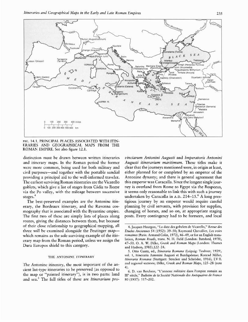
FIG. 14.1. PRINCIPAL PLACES ASSOCIATED WITH ITINERARIES AND GEOGRAPHICAL MAPS FROM THEROMAN EMPIRE. See also figure 12.1.
distinction must be drawn between written itInerariesand itinerary maps. In the Roman period the formerwere more common, being used for both military andcivil purposes-and together with the portable sundialproviding a principal aid to the well-informed traveler.The earliest surviving Roman itineraries are the Vicarellogoblets, which give a list of stages from Cadiz to Romevia the Po valley, with the mileage between successivestages.4
The best-preserved examples are the Antonine itinerary, the Bordeaux itinerary, and the Ravenna cosmography that is associated with the Byzantine empire.The first two of these are simply lists of places alongroutes, giving the distances between them, but becauseof their close relationship to geographical mapping, allthree will be examined alongside the Peutinger mapwhich remains as the sole surviving example of the itinerary map from the Roman period, unless we assign theDura Europos shield to this category.
THE ANTONINE ITINERARY
The Antonine itinerary, the most important of the ancient list-type itineraries to be preserved (as opposed tothe map or "painted itinerary"), is in two parts: landand sea.s The full titles of these are ltinerarium pro-
vinciarum Antonini Augusti and lmperatoris AntoniniAugusti itinerarium maritimum. These titles make itclear that the journeys mentioned were, in origin at least,either planned for or completed by an emperor of theAntonine dynasty; and there is general agreement thatthis emperor was Caracalla. Since the longest single journey is overland from Rome to Egypt via the Bosporus,it seems only reasonable to link this with such a journeyundertaken by Caracalla in A.D. 214-15.6 A long prestigious journey by an emperor would require carefulplanning by civil servants, with provision for supplies,changing of horses, and so on, at appropriate stagingposts. Every contingency had to be foreseen, and local
4. Jacques Heurgon, "La date des gobelets de Vicarello," Revue desEtudes Anciennes 54 (1952): 39-50; Raymond Chevallier, Les voiesromaines (Paris: Armand Colin, 1972),46-49, or for an English translation, Roman Roads, trans. N. H. Field (London: Batsford, 1978),47-50. O. A. W. Dilke, Greek and Roman Maps (London: Thamesand Hudson, 1985),122-24.
5. Otto Cuntz, ed., Itineraria Romana (Leipzig: Teubner, 1929),vol. 1, Itineraria Antonini Augusti et Burdigalense; Konrad Miller,Itineraria Romana (Stuttgart: Strecker und Schroder, 1916), LV H.and regional sections; Dilke, Greek and Roman Maps, 125-28 (note4).
6. D. van Berchem, "L'annone militaire dans I'empire romain auIII' siecle," Bulletin de fa Societe Nationafe des Antiquaires de France80 (1937): 117-202.

236
representatives complained that they often had to makesuch provision at points where in fact the emperor neverstopped at all.? Nevertheless, the existence in the Antonine itinerary of forms of place-names later than Caracalla's reign, such as Diocletianopolis for Pella and Heraclea for Perinthus (Marmara Eregli), suggests thatroutes were reused, with or without amendment, overa long period (fig. 14.1). An example of addition is inSicily, where between Catana (Catania) and Agrigentum(Agrigento) two routes are given, the second includingthe phrase mansionibus nunc institutis (by the stagingposts now set up). The date of the final version of theAntonine itinerary may have been between A.D. 280 and290.
The organization that planned such journeys was thecursus publicus,8 set up by Augustus for transportingofficials and their families and for carrying official mail.Hence the cursus publicus had its own lists, and in somecases straightforward journeys may well have been copied directly from these. But the Antonine itinerary cannotsimply have been a version of those lists, because of thenumerous omissions, duplications, and extremelyroundabout routes. Thus the Peloponnese, Crete, andCyprus are unrepresented, and considerable parts ofGaul, the Balkans, and Asia Minor are thinly covered.A good example of a circuitous route is the second journey in Britain, iter II, which reaches Richborough fromBirrens via Carlisle, York, Chester, and London.9 Sucha route must have been tailor-made for a particular journey, stopping at the legionary fortresses of York andChester among other places.
The method in the Antonine itinerary was to list thestarting and finishing points of each journey and thetotal distance in Roman miles (in Gaul, leagues, as mentioned below). Then the individual stages were listed,with the mileage for each. The totals sometimes correspond to the added individual mileages, sometimes donot; in the latter case especially, one or more of thefigures may well be corrupt.
The Antonine itinerary begins at Tangier and coversmost of the provinces of the empire rather unsystematically. The British section, last before the sea routes, isself-contained and consists of fifteen journeys, some coinciding in the same or the opposite direction. 1o Exceptin cases where they are clearly corrupt, the mileages arefairly reliable. It has been shown, however, that distancesfrom a settlement sometimes start from the center, sometimes from the outskirts.11 Since Colchester is in oneplace called Camulodunum, in another Colonia (it wasone of the four colonies of Roman Britain), one maysuspect that the routes were not all contemporary.
An interpretation of the Antonine itinerary routes innorthern Gaul encounters two difficulties. One is thatdistances in Gaul are sometimes reckoned in Roman
Cartography in Ancient Europe and the Mediterranean
miles, sometimes in leagues, sometimes in both (1 1/2 Roman miles = 1 leuga).12 The other is that there are insome cases considerable differences of mileage betweenthe same two places according to which journey is followed. More research is needed that will not only studythe recorded distances on the modern map, but takeaccount of archaeological and epigraphic evidence, together with such geographical factors as alterations insea level or in the course of riverbeds. 13
ITINERARIES FROM THE LATE EMPIRE
The vast extent of the empire, with its expansion of thebureaucracy, encouraged the production of many itineraries, which, since roads with milestones continued tobe kept up, provided acceptable accuracy.14 As barbarians pressed in from north and east, military requirements became more important then ever. Vegetius, thecivil servant whose military manual dates from aboutA.D. 383-95 but draws on much older material, writesof the ideal general:
In the first place, a commander should have itinerariesof all the war zones very fully written out, so that hemay thoroughly acquaint himself with the interveningterrain, as regards not only distance but standard of
7. Dio Cassius Roman History 78.9.3 and 78.9.6-7; see vol. 9 ofDio's Roman History., 9 vols.., trans. Earnest Cary, Loeb ClassicalLibrary (Cambridge: Harvard University Press; London: WilliamHeinemann, 1914-27).
8. References in Konrat Ziegler and Walther Sontheimer., eds., Derkleine Pauly, 5 vols. (Stuttgart: Alfred Druckenmuller., 1964-75), s.v."cursus publicus," and in Oxford Classical Dictionary, 2d ed., s.v."postal service (Roman)."
9. A. L. F. Rivet and Colin Smith, The Place-Names of RomanBritain (Princeton: Princeton University Press, 1979), 157-60, fig. 12.
10. Rivet and Smith, Place-Names, 148-82 (note 9).11. Warwick Rodwell., "Milestones, Civic Territories and the An
tonine Itinerary," Britannia 6 (1975): 76-101.12. Gallic leagues were officially recognized by Septimius Severus
about A.D. 202.13. Francis J. Carmody, La Gaule des itineraires romains (Berkeley:
Carmody, 1977), contents himself with criticizing Miller's early identification of Vetera, Germania Inferior, with Rheinberg and himselfproposing Alpen. But in fact there has been no dispute for many yearsthat Vetera was quite near the previous station, Colonia Traiana (Xanten). There may have been two successive sites, one three kilometerssoutheast of Xanten, on the Furstenberg north of Birten, the other onland that in Roman times was on the opposite bank of the Rhine,east-northeast of Vetera I. See H. von Petrikovits, "Vetera," in PaulysRealencyclopadie der classischen Altertumswissenschaft, ed. AugustPauly, Georg Wissowa, et al. (Stuttgart: J. B. Metzler, 1894-), 2d ser.,8 (1958): cols. 1801-34, esp. 1813-14.
14. The emperor's name on a milestone often indicates substantialrepair or improvement to a road rather than a new one. For milestonessee the series Itinera Romana, ed. Gerald Sicilia Verbrugghe, IngemarKonig, and Gerold Walser, 3 vols. (Bern: Kiimmerly und Frey, 196776); Jeffrey P. Sedgley, The Roman Milestones of Britain: TheirPetrography and Probable Origin, British Archaeological Reports no.18 (Oxford: British Archaeological Reports, 1975).

Itineraries and Geographical Maps in the Early and Late Roman Empires 237
roads, and may study reliable descriptions of shortcuts, deviations, mountains, and rivers. In fact, weare assured that the more careful commanders had,for provinces in which there was an emergency, itineraries that were not merely annotated but even drawnout in color [picta], so that the commander who wassetting out could choose his route not only with amental map but with a constructed map to examine. is
Itineraries were also used by pilgrims and by soldiersrejoining their legions; they were expected to take goodcare of them, not to leave the route, and to stop at themansiones (staging posts) indicated. 16
The official recognition of the Christian church in A.D.
313 affected cartography as it did other branches ofscience; one direct result was that pilgrimages to Christian shrines created a new use for geographical itineraries. The principal itinerary of the late empire is thatof the Bordeaux-Jerusalem pilgrimage, A.D. 333, ofwhich the best manuscript is the Pithoeanus, now Par.Lat. 4808, of the ninth century (no maps).1? Distancesare recorded in leagues (2.22 km) as far as Toulouse,then in Roman miles (1.48 km). Another itinerary attached to this records a journey from the Holy Land toChalcedon (Kadikoy), in Asia Minor opposite Constantinople, and back via Nicomedia (Izmit), Ancyra (Ankara), Tarsus, and Tyre. A third goes from HeracleaPontica (Eregli) via Macedonia, Albania, and the eastcoast of Italy. In addition to this major document, thereare fragments of itineraries from monumental inscriptions of various periods from several territories underthe Roman Empire. 18
A second category of written itineraries relates to journeys made by sea. It has already been noted that partof the Antonine itinerary consisted of an itinerariummaritimum, and in view of theories about an associationbetween these periploi and the development of portolancharts,19 such itineraries have been widely discussed inthe literature of the history of cartography. An anonymous and incomplete Greek periplus of about the thirdor fourth century A.D. is known as the Stadiasmus marismagni.2o It records distances in stades between harborsand watering facilities around most of the eastern Mediterranean, covering the North African coast as far westas Utica. Thus a fair amount of detail is given in theentry for even such a small area as Djerba Island, Tunisia. Rhodes is particularly well covered, with sea distances to twenty-seven harbors of the eastern Mediterranean and Aegean. But some areas, such as the Levant,are very poorly covered. Muller questionably attributedthe whole work to a much later period.21
It is likely that writers in some ports specialized in theproduction of these aids to the mariner, and such wasMarcianus of Heraclea Pontica, a Greek writer of periploi, who is thought to have been a contemporary of
Synesius of Cyrene, about 370-413. Among his sourceshe mentions the Geography of "the most divine and wisePtolemy," whose coordinates he clearly edited.22 He accepts the size of the earth according to Ptolemy, notEratosthenes' measurement of the circumference of theearth. The surviving parts of his Periplus maris exteri23
cover the southern coasts of Asia (which he may wellhave illustrated by a map based on Ptolemy's coordinates) and the coasts of the less familiar parts of Europe;some, such as the Iberian Peninsula, are covered in
15. Vegetius De re militari (Military Institutions of the Romans)3.6, author's translation. No annotated itineraries are extant, but fromVegetius's previous words they must have commented among otherthings on quality of road surface. The words "there was an emergency"render the past tense gerebatur, which, however, is a conjecture forthe present geritur by Carl Lang in his edition of Vegetius, Epitomarei militaris, 2d ed. (Leipzig: Teubner, 1885), 75. Pascal Arnaud (criticism at a seminar 12 December 1983 on "La Tabula Peutingerianaet Ie Corpus Agrimensorum" at Centre Jean Berard, Institut Fran<;aisde Naples) takes picta differently as referring to itineraries with paintings.
16. Saint Ambrose (bishop of Milan) Expositio in psalmum 1185.2; see Opera, pars quinta (V): Expositio psalmi CXVIII, ed. MichaelPetschenig in Corpus Scriptorum Ecclesiasticorum Latinorum, vol. 62(Vienna: F. Tempsky; Leipzig: G. Freytag, 1913), 82-83.
17. Cuntz, Itineraria Romana (note 5); P. Geyer and Otto Cuntz,"Itinerarium Burdigalense," in Itineraria et alia geographica, in CorpusChristianorum, Series Latina, vols. 175 and 176 (1965), 175:XVIII26; Henri Leclercq, "Itineraires," in Dictionnaire d'archeologie chretienne et de liturgie, 15 vols., ed. Fernand Cabrol and Henri Leclercq(Paris: Letouzey et Ane, 1907-53), 7.2 (1927): cols. 1841-1922, esp.1853-58; Aubrey Stewart, trans., Itinerary from Bordeaux to Jerusalem: "The Bordeaux Pilgrim," Palestine Pilgrims Text Society, vol.1, no. 2 (London: Palestine Exploration Fund, 1896), 15 H., abstractedby George Kish, ed., A Source Book in Geography (Cambridge: Harvard University Press, 1978), 156-58.
18. Wilhelm Kubitschek, "Itinerarien," in Realencyclopiidie 9(1916): cols. 2308-63, esp. 2314 ff. (note 13); Miller, Itineraria Romana, LIV ff. (note 5); Leclercq, "Itineraires," cols. 1841 H. (note 17);Annalina Levi and Mario Levi, Itineraria picta: Contributo allo studiodella Tabula Peutingeriana (Rome: Erma di Bretschneider, 1967), 2728, n. 29. Two of these are on pilasters, one on a column, others onstone or terra-cotta tablets. An inscription from Solin, Yugoslavia, thetown near Diocletian's palace at Split, lists four roads leading fromthere. Of three Gallic inscriptions, one at Autun lists part of the roadfrom there to Rome; one from Valence refers to the road to Vienna(Vienne, France); and one in Luxembourg covers part of the areabetween there and Mainz. A columbarium fragment at Vigna Codiniis thought to refer to the main road from Cilicia or Syria to Rome.
19. See chapter 19 in this volume, "Portolan Charts from the LateThirteenth Century to 1500," pp. 371-436. The latest writer on periploi, Pietro Janni, La mappa e il periplo: Cartografia antica e spazioodologico, Universita di Macerata, Pubblicazioni della Facolta di Lettere e Filosofia 19 (Rome: Bretschneider, 1984), rightly stresses thelack of maps in periploi.
20. See Karl Muller, ed., Geographi Graeci minores, 2 vols. andtabulae (Paris: Firmin-Didot, 1855-56), 1:427-514.
21. Muller, Geographi Graeci minores, l:cxxiii-cxxviii (note 20).22. Marcianus Periplus maris exteri in Muller, Geographi Graeci
minores, 1:515-62, quotation on 516 (note 20), author's translation.23. See note 22 above.
238
greater detail than others. For southern Asia he givesfuller measurements as far as Gedrosia (Pakistan westof the Indus), then in less detail.
THE PEUTINGER MAP
The road map known as the Peutinger map,24 CodexVindobonensis 324, was originally a long, narrowparchment roll, 6.75 meters long but only 34 centimeterswide. It is in the Nationalbibliothek, Vienna, and hasbeen divided into sections for preservation. Its date oftranscription is twelfth or early thirteenth century, butit has long been recognized as a copy of an ancient map.In his will of 1508, the humanist Konrad Celtes ofVienna left to Konrad Peutinger (in whose hands it hadbeen since the previous year) what he called ItinerariumAntonini. This was not justified as a title: it is indeed aroad map, but not connected with the Antonine emperors and different from the Antonine itinerary describedabove. It was first published in 1598 by Markus Welser,a relative of the Peutingers, and since 1618 it has generally been known as the Tabula Peutingeriana or translations of that phrase.25 The original roll at the time ofits transcription in the early Middle Ages was of elevensheets, but as such it was incomplete, since much ofBritain, Spain, and the western part of North Africa werealready missing at the time of copying; there may alsohave been an introductory sheet forming part of an earlier prototype version. It was evidently not, as was oncethought, the work of the Dominican monk Konrad ofColmar, who in 1265 quite independently produced amappamundi that he says he copied onto twelve parchment pages; the paleography suggests an earlier date.The second sheet of the Peutinger map was treated as ifit had been the first, with spellings of truncated namescontaining false initial capitals (for example, Ridumofor what was originally Moriduno). Hence a total oftwelve sheets extant at the time of copying can be accounted for only by assuming that, when the copyistmentioned this number, he was including a title sheet.26
The Peutinger map was primarily drawn to show mainroads, totaling some 70,000 Roman miles (104,000 km),and to depict features such as staging posts, spas, distances between stages, large rivers, and forests (represented as groups of trees). It is not a military map, thoughit could have been used for military purposes, but thewords of Vegetius quoted above (pp. 236-37) give anindication of its possible function. They suggest that,whether or not the term itinerarium pictum (painteditinerary), was in current use, it is a convenient phrasefor this unique map.27 The distances are normally recorded in Roman miles, but for Gaul they are in leagues,for Persian lands in parasangs, and for India evidentlyin Indian miles.
Cartography in Ancient Europe and the Mediterranean
The proportions of the Peutinger map are such thatdistances east-west are represented at a much larger scalethan distances north-south; for example, Rome looks asthough it were nearer to Carthage than Naples is toPompeii. The archetype may well have been on a papyrusroll, designed for carrying round in a capsa (roll box).As such, its width would be severely limited, whereasits length would not. In the extant map a north-southroad tends to appear at only a slightly different anglefrom an east-west one, and distances are calculated notby the map's scale but by adding up the mileages ofsuccessive staging posts.
The date of the archetype is likely to have been between A.D. 335 and 366. Such dating is suggested by thethree personifications placed on Rome, Constantinople(labeled Constantinopolis, not Byzantium), and Antioch; and it fits in well enough with biblical referenceson the map. Sometime after the foundation of Constantinople in A.D. 330 as a new Rome on the site of Byzantium, Antioch was recognized as the important bastion against the Parthians. But the suggestion that thisfourth-century archetype was based on a much earliermap would account for the inclusion of Herculaneum,Oplontis, and Pompeii, which had been destroyed in theeruption of Vesuvius in A.D. 79 and not rebuilt, exceptfor parts of Pompeii. It is also perhaps easier, on thissupposition, to see why certain roads are omitted, suchas the major routes through the Parthian empire mentioned in the Mansiones Parthicae (Parthian stations) ofIsidorus of Charax. This work is believed to have beencompiled in the late first century A.D.
28
24. Ekkehard Weber, ed., Tabula Peutingeriana: Codex Vindobonensis 324 (Graz: Akademische Druck- und Verlagsanstalt, 1976);Konrad Miller, Die Peutingersche Tafel (Stuttgart: F. A. Brockhaus,1962); Levi and Levi, Itineraria picta (note 18); Luciano Bosio, LaTabula Peutingeriana: Una descrizione pittorica del mondo antico, IMonumenti dell'Arte Classica, vol. 2 (Rimini: Maggioli, 1983). Dilke,Greek and Roman Maps, 113-20 (note 4).
25. Tabula is one Latin word for a map, but forma is more common.Inexplicably, the word tabula has been translated "table" rather than"picture" or "map" in popular usage. It is now time to call it the"Peutinger map" to avoid any misconception that the original imagewas somehow carved on a table or was like a statistical table. Thealternative naming of the Peutinger map as the "world map of Castorius" has met with very little support. Castorius, a geographicalwriter of the fourth century A.D., is several times mentioned as a sourcein the Ravenna cosmography; but there is no evidence to link himdirectly with the Peutinger map.
26. During this century preservation has been a major problem,particularly since the green coloring used on the parchment has resulted in deterioration of the sea portions of the map. Photographingmaps through the glass covers used for preservation has producedinaccurate colors in some reproductions.
27. Hence the title of Levi and Levi, Itineraria picta (note 18). Foran alternative suggestion, see end of note 15.
28. For a discussion of the date and the significance of Isidorus ofCharax, see Sheldon Arthur Nodelman, "A Preliminary History of

Itineraries and Geographical Maps in the Early and Late Roman Empires 239
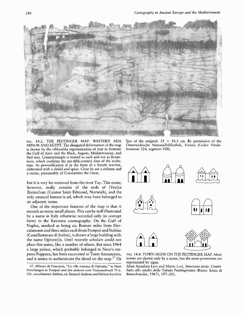
Around the personification of Rome-a female figureon a throne holding a globe, a spear, and a shield-aretwelve main roads, each with its name attached, a practice not adopted elsewhere (plate 5). The Tiber is correctly shown with 90 percent of the city on its left bank.But owing to the personification the city surround isformally shown as a circle, enlarged in proportion to thevery narrow width of the Italian peninsula. The ViaTriumphalis is indicated as leading to a church of SaintPeter; the words ad scm [sanctum] Petrum are given inlarge minuscules on the medieval copy. Ostia is shownwith a harbor occupying about one-third of a circle, ina fashion similar to that of miniatures in the early manuscripts of Virgil's Aeneid.29 Constantinople is represented by a helmeted female figure seated on a throneand holding in her left hand a spear and a shield (fig.14.2). Nearby is a high column (rather than a lighthouse)3o surmounted by the statue of a warrior, presumably Constantine the Great. Antioch has a similarfemale personification, perhaps originating in a statueof the Tyche (fortune) of the city, together with archesof an aqueduct or possibly of a bridge. Nearby is thepark of Daphne, dedicated to Apollo and other gods andfamous for its natural beauty and as a leisure center (fig.14.3). Even though the temple of Apollo was burneddown in 362, there were many other temples, so thatthis is not necessarily a guide to the dating. It has beenclaimed that in A.D. 365-66 all three personified citieswere important, since the pretender Procopius had hisseat of power in Constantinople, Valentinian I in Rome,and his brother Valens in Antioch.31 But in fact, althoughValens set out for Antioch, he was diverted to fightProcopius and he cannot be correctly associated withthat last-named city.32
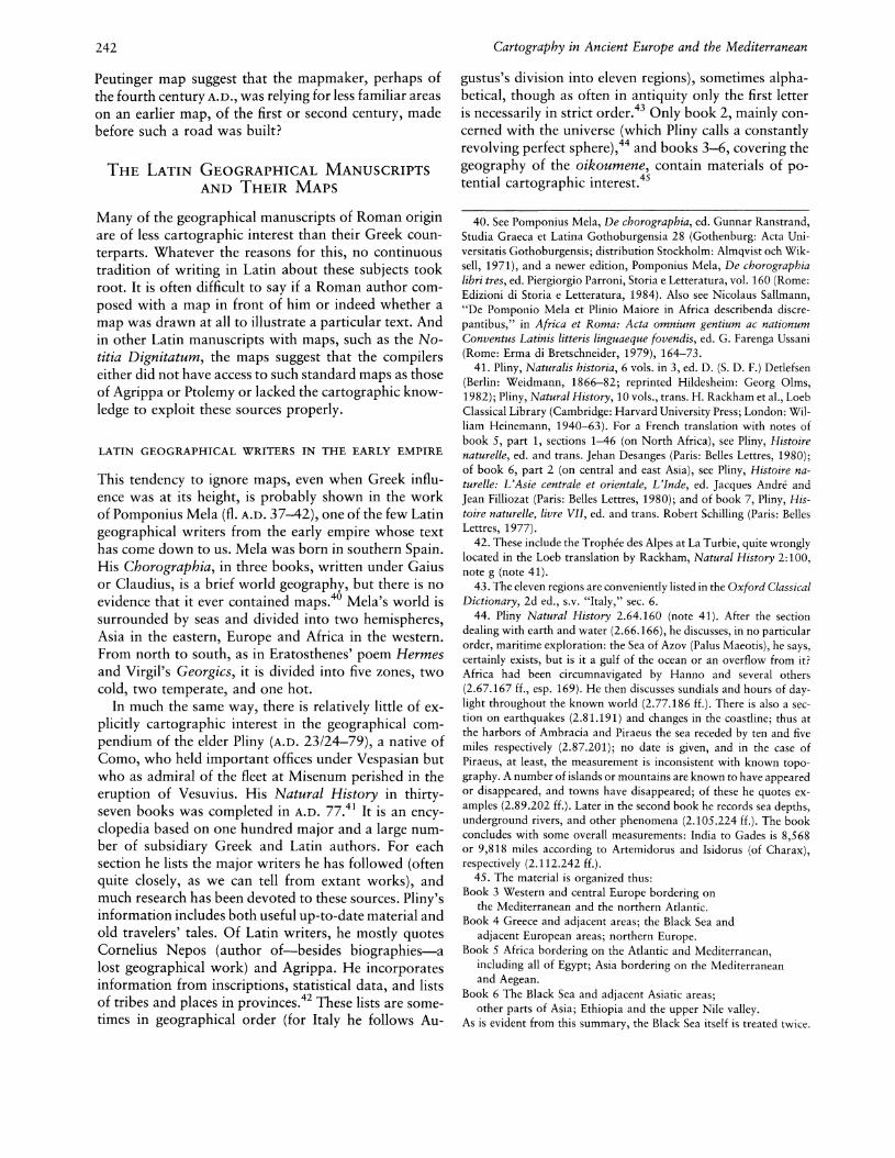
Throughout the map, mountains are marked in palebrown and principal rivers in green. Names of countriesand of some tribes are recorded. Apart from the personifications, cartographic signs include representationsof harbors, altars, granaries, spas, and settlements. Aunique sign is that for a tunnel @ , used for the CryptaNeapolitana, near Pozzuoli. Harbors, if indicated, aregiven the arcuate shape mentioned in connection withOstia. The sign for a spa is an ideogram of a roughlysquare building with an internal courtyard, often witha gabled tower at each end of the near side. There arefifty-two such buildings represented, of which twentyeight are at places specifically called Aquae; in someother cases there is reason to think that a place so denoted had prominent baths.33 There are also in the Peutinger map places with cartographic signs for granaries,denoted as rectangular roofed buildings. One such isCentumcellae (Civitavecchia), which had a corn-importing harbor of some size. Variants of a two-gabledbuilding were used to depict some settlements, but most
were distinguished by no more than a name (fig. 14.4).Attempts to differentiate between types of settlementson the map and to establish criteria for the attributionof signs have not been entirely successful. Certain important cities are shown with walls: Aquileia, Ravenna,Thessalonica (Salonika), Nicaea (Iznik), Nicomedia, andAncyra. But why should the triple-gable sign appear onlyat Forum Iulii (Frejus), Augusta Taurinorum (Turin),Luca (Lucca), Narona (on the Neretva River), and Tomis(Constanta) ?34 It is interesting to see that, just as thereis one personification in the West and two in the East,so two cities of the second rank, symbolically givenwalls, are in the West and four in the East. Importantcities like Carthage, Ephesus, and Alexandria are notshown with a distinctive sign.
The road network is thought to have been based (atleast within the empire) on information held by the cursus publicus, responsible for organizing the official transport system set up by AugustuS.35 This system, extendedunder the late empire to troop movements, relied verylargely on staging posts at more or less regular intervals;couriers traveled an average of fifty Roman miles (74km) a day.
The part of the British section of the Peutinger mapthat survives is so fragmentary that it covers only alimited area of the southeast, not even including London,and an even smaller area around Exeter.36 Colchester,surprisingly, is given no cartographic sign. The mostnortherly place extant in Britain appears as "Ad Taum";
Characene," Berytus 13 (1960): 83-121, esp. 107-8, and Fergus Millar, "Emperors, Frontiers and Foreign Relations, 31 B.C. to A.D. 378,"Britannia 13 (1982): 1-23, esp. 16.
29. For example, Rome, Biblioteca Apostolica Vaticana, Vat. Lat.3225, of about A.D. 420; the importance of its miniatures for thehistory of cartography has been recognized.
30. The latter is the interpretation of Levi and Levi, Itineraria picta,153-54 (note 18).
31. Levi and Levi, Itineraria picta, 65 H. (note 18).32. Glanville Downey, A History ofAntioch in Syria: From Seleucus
to the Arab Conquest (Princeton: Princeton University Press, 1961),399-400.
33. The closest parallel to the use of this convention is in a workof doubtful authenticity, the so-called Bellori picture, found on theEsquiline in 1668 but now lost. Which settlement was intended to berepresented on that veduta prospettiva is uncertain; it may have beenPozzuoli. See P. S. Bartoli's drawing in Giovanni Pietro Bellori, Ichnographia veteris Romae (Rome: Chalcographia R.C.A., 1764), 1. Ichnographia is a word Vitruvius used for the drawing of a ground plan inDe architectura 1.2.2; see On Architecture, 2 vols., trans. Frank Granger, Loeb Classical Library (Cambridge: Harvard University Press;London: William Heinemann, 1931-34).
34. Levi and Levi, Itineraria picta, 92-93 (note 18), compare thiswith an incised glass beaker depicting seaside houses with triple gablesin the Bay of Naples (New York, Metropolitan Museum): R. W. Smith,"The Significance of Roman Glass," Metropolitan Museum Bulletin8 (1949): 56.
35. See above, p. 236 and n. 8.36. Rivet and Smith, Place-Names, 149-50 (note 9).
240 Cartography in Ancient Europe and the Mediterranean
~.ize of the original: 33 x 56.3 em. By permission of theOsterreichische Nationalbibliothek, Vienna (Codex Vindobonensis 324, segment VIII).
FIG. 14.4. TOWN SIGNS ON THE PEUTINGER MAP. Mosttowns are shown only by a name, but the more prominent arerepresented by signs.After Annalina Levi and Mario Levi, Itineraria picta: Contributo allo studio della Tabula Peutingeriana (Rome: Erma diBretschneider, 1967), 197-201.
~~
but it is very far removed from the river Tay. This name,however, really consists of the ends of [Ven]ta[lcenor]um (Caistor Saint Edmund, Norwich), and theonly unusual feature is ad, which may have belonged toan adjacent name.
One of the important features of the map is that itrecords so many small places. This can be well illustratedby a name in Italy otherwise recorded only (in corruptform) in the Ravenna cosmography. On the Gulf ofNaples, marked as being six Roman miles from Herculaneum and three miles each from Pompeii and Stabiae(Castellammare di Stabia), is shown a large building withthe name Oplont(i)s. Until recently scholars could notplace this name, like a number of others. But since 1964a large palace, which probably belonged to Nero's empress Poppaea, has been excavated at Torre Annunziata,and it seems to authenticate the detail on the map.3? Or
37. Alfonso de Franciscis, "La villa romana di Oplontis," in NeueForschungen in Pompeji und den anderen vom Vesuvausbruch 79 n.Chr. verschutteten Stiidten, ed. Bernard Andreae and Helmut Kyrieleis
FIG. 14.2. THE PEUTINGER MAP: WESTERN ASIAMINOR AND EGYPT. The elongated deformation of the mapis shown by the ribbonlike representation of (top to bottom)the Gulf of Azov and the Black, Aegean, Mediterranean, andRed seas. Constantinople is named as such and not as Byzantium, which confirms the pre-fifth-century date of the archetype. Its personification is in the form of a female warrior,enthroned with a shield and spear. Close by are a column anda statue, presumably of Constantine the Great.

Itineraries and Geographical Maps in the Early and Late Roman Empires 241
FIG. 14.3. THE PEUTINGER MAP: THE EASTERN MEDITERRANEAN. The north-south axis of Syria and the HolyLand is here shown parallel to Asia Minor and Cyprus. Theprominent city to the right of Cyprus is Antioch, the third ofthe cities on the map personified as a seated figure with spearand shield.
again, a much earlier discovery near Aquileia in 1830appears to correspond to an entry on the Peutinger map.A large bathing establishment, mentioned also by theelder Pliny, was discovered on the lower reaches of theriver Isonzo.38 This is probably the place given the cartographic sign for a spa, with the words Fonte Timavi(spring of the river Timavus). Its fresh waters by the seawere regarded as an unusual phenomenon and obviouslyworth mapping.
Owing to the shape of the map, the Nile could notbe represented as a long river if it were made to flownorthward throughout its course. Instead it is made torise in the mountains of Cyrenaica and to flow "eastward" to a point just above the delta. The delta itself isshown in less compressed form from south to north thanmost parts of the Peutinger map (see fig. 14.2). Thedistributaries of the Nile are shown to have many islands, three of them marked with temples of Serapis,three with temples of Isis, while the roads are somewhatdiscontinuous. On the Sinai desert we find the wordsdesertum ubi quadraginta annis erraverunt filii Israelisdueente Moyse (the desert where the children of Israel
~.ize of the original: 33 x 61.4 em. By permission of theOsterreichische Nationalbibliothek, Vienna (Codex Vindobonensis 324, segment IX).
wandered for forty years guided by Moses), and thereare other biblical references. There is also an area incentral Asia labeled Hie Alexander responsum aeeepitusq[ue] quo Alexander (Here Alexander was given theoracular reply: "How far, Alexander?"). Perhaps theseampler descriptions, whether Christian or pagan, wereadded on otherwise empty space about the fifth or sixthcentury A.D. In several areas research is in progress combining fieldwork with study of the Peutinger map andof the history of place-names. One such is the area between the Gulf of Aqaba and Damascus.39 A questionthat emerges is the extent to which we can argue fromsilence: Does the absence of an important road on the
(Recklinghausen: Aurel Bongers, 1975), 9-38; Carlo Melandrino,Oplontis (Naples: Loffredo, 1977).
38. Luciano Bosio, La "Tabula Peutingeriana": Una carta stradaleromana del IV secolo (Florence: 3M Italia and Nuova Italia, 1972),16 (text accompanying filmstrip).
39. Dr. D. L. Kennedy of the University of Sheffield is researchingon behalf of the Aerial Photographic Archive for Archaeology in theMiddle East, and Professor G. W. Bowersock gave a talk on the subjectat the University of London in 1980.
242
Peutinger map suggest that the mapmaker, perhaps ofthe fourth century A.D., was relying for less familiar areason an earlier map, of the first or second century, madebefore such a road was built?
THE LATIN GEOGRAPHICAL MANUSCRIPTSAND THEIR MAPS
Many of the geographical manuscripts of Roman originare of less cartographic interest than their Greek counterparts. Whatever the reasons for this, no continuoustradition of writing in Latin about these subjects tookroot. It is often difficult to say if a Roman author composed with a map in front of him or indeed whether amap was drawn at all to illustrate a particular text. Andin other Latin manuscripts with maps, such as the Notitia Dignitatum, the maps suggest that the compilerseither did not have access to such standard maps as thoseof Agrippa or Ptolemy or lacked the cartographic knowledge to exploit these sources properly.
LATIN GEOGRAPHICAL WRITERS IN THE EARLY EMPIRE
This tendency to ignore maps, even when Greek influence was at its height, is probably shown in the workof Pomponius Mela (fl. A.D. 37-42), one of the few Latingeographical writers from the early empire whose texthas come down to us. Mela was born in southern Spain.His Chorographia, in three books, written under Gaiusor Claudius, is a brief world geography, but there is noevidence that it ever contained maps.40 Mela's world issurrounded by seas and divided into two hemispheres,Asia in the eastern, Europe and Africa in the western.From north to south, as in Eratosthenes' poem Hermesand Virgil's Georgics, it is divided into five zones, twocold, two temperate, and one hot.
In much the same way, there is relatively little of explicitly cartographic interest in the geographical compendium of the elder Pliny (A.D. 23/24-79), a native ofComo, who held important offices under Vespasian butwho as admiral of the fleet at Misenum perished in theeruption of Vesuvius. His Natural History in thirtyseven books was completed in A.D. 77.41 It is an encyclopedia based on one hundred major and a large number of subsidiary Greek and Latin authors. For eachsection he lists the major writers he has followed (oftenquite closely, as we can tell from extant works), andmuch research has been devoted to these sources. Pliny'sinformation includes both useful up-to-date material andold travelers' tales. Of Latin writers, he mostly quotesCornelius Nepos (author of-besides biographies-alost geographical work) and Agrippa. He incorporatesinformation from inscriptions, statistical data, and listsof tribes and places in provinces.42 These lists are sometimes in geographical order (for Italy he follows Au-
Cartography in Ancient Europe and the Mediterranean
gustus's division into eleven regions), sometimes alphabetical, though as often in antiquity only the first letteris necessarily in strict order.43 Only book 2, mainly concerned with the universe (which Pliny calls a constantlyrevolving perfect sphere),44 and books 3-6, covering thegeography of the oikoumene, contain materials of potential cartographic interest.45
40. See Pomponius Mela, De chorographia, ed. Gunnar Ranstrand,Studia Graeca et Latina Gothoburgensia 28 (Gothenburg: Acta Universitatis Gothoburgensis; distribution Stockholm: Almqvist och Wiksell, 1971), and a newer edition, Pomponius Mela, De chorographialibri tres, ed. Piergiorgio Parroni, Storia e Letteratura, vol. 160 (Rome:Edizioni di Storia e Letteratura, 1984). Also see Nicolaus Sallmann,"De Pomponio Mela et Plinio Maiore in Africa describenda discrepantibus," in Africa et Roma: Acta omnium gentium ac nationumConventus Latinis litteris linguaeque fovendis, ed. G. Farenga Ussani(Rome: Erma di Bretschneider, 1979), 164-73.
41. Pliny, Naturalis historia, 6 vols. in 3, ed. D. (S. D. F.) Detlefsen(Berlin: Weidmann, 1866-82; reprinted Hildesheim: Georg Olms,1982); Pliny, Natural History, 10 vols., trans. H. Rackham et aI., LoebClassical Library (Cambridge: Harvard University Press; London: William Heinemann, 1940-63). For a French translation with notes ofbook 5, part 1, sections 1-46 (on North Africa), see Pliny, Histoirenaturelle, ed. and trans. Jehan Desanges (Paris: Belles Lettres, 1980);of book 6, part 2 (on central and east Asia), see Pliny, Histoire naturelle: L'Asie centrale et orientale:J L:JInde, ed. Jacques Andre andJean Filliozat (Paris: Belles Lettres, 1980); and of book 7, Pliny, Histoire naturelle:J livre VII, ed. and trans. Robert Schilling (Paris: BellesLettres, 1977).
42. These include the Trophee des Alpes at La Turbie, quite wronglylocated in the Loeb translation by Rackham, Natural History 2:100,note g (note 41).
43. The eleven regions are conveniently listed in the Oxford ClassicalDictionary, 2d ed., s.v. "Italy," sec. 6.
44. Pliny Natural History 2.64.160 (note 41). After the sectiondealing with earth and water (2.66.166), he discusses, in no particularorder, maritime exploration: the Sea of Azov (Palus Maeotis), he says,certainly exists, but is it a gulf of the ocean or an overflow from it?Africa had been circumnavigated by Hanno and several others(2.67.167 ff., esp. 169). He then discusses sundials and hours of daylight throughout the known world (2.77.186 ff.). There is also a section on earthquakes (2.81.191) and changes in the coastline; thus atthe harbors of Ambracia and Piraeus the sea receded by ten and fivemiles respectively (2.87.201); no date is given, and in the case ofPiraeus, at least, the measurement is inconsistent with known topography. A number of islands or mountains are known to have appearedor disappeared, and towns have disappeared; of these he quotes examples (2.89.202 ff.). Later in the second book he records sea depths,underground rivers, and other phenomena (2.105.224 ff.). The bookconcludes with some overall measurements: India to Gades is 8,568or 9,818 miles according to Artemidorus and Isidorus (of Charax),respectively (2.112.242 ff.).
45. The material is organized thus:Book 3 Western and central Europe bordering on
the Mediterranean and the northern Atlantic.Book 4 Greece and adjacent areas; the Black Sea and
adjacent European areas; northern Europe.Book 5 Africa bordering on the Atlantic and Mediterranean,
including all of Egypt; Asia bordering on the Mediterraneanand Aegean.
Book 6 The Black Sea and adjacent Asiatic areas;other parts of Asia; Ethiopia and the upper Nile valley.
As is evident from this summary, the Black Sea itself is treated twice.
Itineraries and Geographical Maps in the Early and Late Roman Empires 243
From these books it is clear that Pliny was a user ofmaps rather than a contributor to the theory of theirconstruction or compilation. Unfortunately, in giving hissources he does not distinguish between maps and written geographies. Thus we have to infer his use of mapsby indirect means such as the cited measurements between places or his descriptions of countries and citiesin terms of their shapes. With respect to the latter, forexample, Italy is not as today described as boot-shapedbut is said to be like an elongated oak leaf, bending tothe left at the top and "ending in the shape of an Amazon's shield,,46 (following Strabo and Eratosthenes);the Peloponnese has the shape of a plane tree leaf; andso on.47
There are two passages where the context may beconsidered fully cartographic. The first is where he criticizes the length and breadth of Baetica, southern Spain,as given in Agrippa's map and approved by AugustuS.48
The second is where he says: "There are a number ofsegments of the earth which we Romans have calledcircles, while the Greeks have called them parallels. ,,49He then gives what we may define as seven climata (hedoes not use the word) from south to north, with lengthsof gnomon shadows, numbers of hours in longest days,and principal countries or cities. These range from southern India and the two provinces of Mauretania (the latterare in fact at a very different latitude from southernIndia) to the north of the Black Sea and Aquitania. Plinyattributes these to earlier Greek theory, but he also givesthree additional zones to the north, which he says laterGreek geographers have added.
Other evidence is not quite so conclusive; it may depend on our interpretation of posuere (they have placed).Pliny may well be thinking of placing on a map, but wecannot be sure. Thus in one passage he writes: "Thenthere projects into the sea a promontory with a vasthorn, which some have called Artabrum [from CapeRoca to Lisbon].... The distance from here to thePyrenees is given by quite a number as 1,250 miles, andthey record there a non-existent tribe of Artabres: theyhave placed [posuere] in this area, by a change of lettering, the Arrotrebae whom I mentioned before theCeltic Promontory [Finisterre]. ,,50 Similarly in anotherpassage, "Others have placed [posuere] the Gedrusi andSires over a stretch of 138 miles, then the fish-eatingOritae, who do not speak the Indian language, for 200miles.,,51 We may also feel that Pliny is more likely tohave been looking at a map than a book when he compares the Arabian peninsula to Italy not merely for beingsurrounded by two seas but for having what he calls the
. . 52same orIentatIon.
LATIN GEOGRAPHICAL WRITERS IN THE LATE EMPIRE
During the late empire, Latin geographical writing seemsto have been confined to relatively few channels of trans-
mission. Indeed, although there are other manuscriptswith maps, only three main writers-Avienius, Macrobius, and Julius Honorius-can be noted under the present heading.53 Only the second of these can definitelybe said to have written a work containing maps. Thispoverty in the Roman tradition may partly reflect thefact that some of the more important texts containingcartographic knowledge continued to be written inGreek rather than in Latin. This is shown by the workof Agathemerus, whose brief prose manual summarizesGreek mapmaking up to the first century B.C.
54 RufusFestus Avienius,55 a senator from Volsinii in Etruria,wrote two geographical works in Latin verse about A.D.
380-400. The first is a general work in hexameters,Descriptio orbis terrae, intended as a revision of theGreek work of Dionysius Periegetes. The second, Oramaritima, contains only 703 iambs but is thought to beincomplete.56
The commentary by Ambrosius Theodosius Macrobius (fl. A.D. 399-422) on Cicero's Somnium Scipionis(The dream of Scipio, incorporated in his Republic) contains cosmology and Macrobius's impression of the appearance of the world.57 Whereas he accepts Eratosthenes' sphericity and measurement, he turns to Crates
46. Pliny Natural History 3.5.43 (note 41). Shaped like a crescentbut with two curves on the inner side and a promontory betweenthem.
47. See chapter 10, "Greek Cartography in the Early RomanWorld," esp. pp. 174-75.
48. Pliny Natural History 3.1.16-3.2.17 (note 41); see also above,pp.207-8.
49. Pliny Natural History 6.39.211-20, esp. 212 (note 41), author'stranslation.
50. Pliny Natural History 4.21.113-4.22.14 (note 41), author'stranslation.
51. Pliny Natural History 6.25.95 (note 41), author's translation.52. Pliny Natural History 6.32.143 (note 41).53. There are also several extant geographical manuscripts in Latin
without maps. For example, Vibius Sequester, De fluminibus~fontibus~
lacubus~ nemoribus~paludibus~montibus~gentibus per litteras libellus,ed. Remus Gelsomino (Leipzig: Teubner, 1967), is an alphabeticalgazetteer listing, under separate headings, rivers, springs, lakes, groves,marshes, mountains, and peoples. Similarly, two accounts are providedof the boundaries of provinces and of countries outside the empire,based on Agrippa's map or a revision: Dimensuratio provinciarumand Divisio orbis terrarum , both in Geographi Latini minores, ed.Alexander Riese (Heilbronn, 1878; reprinted Hildesheim: GeorgOlms, 1964), 9-14 and 15-23 respectively.
54. Agathemerus Geographica antiqua, ed. Jacobus Gronovius (Leiden: J. Luchtmans, 1700); and Geographiae informatio, in Miiller,Geographi Graeci minores 2:471-87 (note 20).
55. Avienius, not Avienus, is the correct form: Alan Cameron, "Macrobius, Avienus, and Avianus," Classical Quarterly, n.s., 17 (1967):385-99, esp. 392 ff.
56. See Avienius, Rufi Festi Avieni Carmina, ed. Alfred Holder(Innsbruck, 1887; reprinted Hildesheim: Georg Olms, 1965), chap. 3and chap. 4, which contains both works. For further references onthe Ora Maritima, see chapter 9, p. 150 and n. 16.
57. Macrobius, Commentary on the Dream ofScipio, ed. and trans.W. H. Stahl (New York: Columbia University Press, 1952).

244
of Mallos for the concept of ocean and land masses:"Separating us from the people of the southern hemisphere, Ocean flows along the whole extent of the equator; again, as its streams branch out at the extremitiesof both regions, it forms two islands on the upper faceof the earth and two on the underside.,,58 Later he adds:"The accompanying diagram will lay everything beforeour eyes" and "from our diagram we shall also understand Cicero's statement that our quarter is narrow atthe top and broad at the sides.,,59 Macrobius's map ofthe world was circular (2.5.13), with north at the topand with cold, temperate, and hot regions, though perhaps its equatorial ocean was narrower in latitude thanis shown in manuscripts and printed editions. The manuscript maps accompanying the commentary had astrong influence on zone maps of the Middle Ages.
The Cosmographia of Julius Honorius is an inaccuratecompilation of about the fifth century; only excerptssurvive.60 His list starting Seres oppidum, Theriodes oppidum . totally confuses settlements, tribes, andeven rivers, calling them all towns.61 He selects a fewplaces in northern Italy, partly in topographical order,partly not, before suddenly switching to Dalmatia. Oneof the most incorrect entries may be rendered: "The riverChrysorroas rises in the plains of Syria and flows throughSyria, Antioch, and Palestine and the remaining cities ofSyria. Its mouth is in the Aegean, where the island ofCyprus is. It runs for 830 miles.,,62
THE NOTITIA DIGNITATUM
The full title of this work may be translated "directoryof officeholders and administration, both civil and military.,,63 There are primary manuscripts at Cambridge,Frankfort, Munich, Oxford, and Paris.64 Some of theseare known, and all are thought, to have been copiedfrom a codex Spirensis (that is, of Speyer cathedral),which was written in the tenth century but disappearedin the sixteenth century. They are all illustrated, and theMunich manuscript has two sets of illustrations.65
The main divisions in the work are between the easternand the western empires and between civil and militaryofficials. The official list was kept by the head of thecivil service in the West, though it is disputed whetherthe extant work is governmental or an amateur's copy.Its date is between 395 and 413, and it may have beenrevised even later.
Illustrations consist of insignia of officials, personifications of provinces, picture maps, and miscellaneousitems. Many maps are such as only a bureaucrat unfamiliar with the areas could have produced; and it isconsidered likely that there has been much change oraddition.66 Thus the map of Britain under the heading"vicarius Britanniarum" has five provinces arranged 1,2, 2, from north (top) to south, with "Britannia Prima"
Cartography in Ancient Europe and the Mediterranean
in the southeast (plate 6).67 But we know from the metrical epitaph of a governor that Corinium (Cirencester)was the capital of Britannia Prima; and it is likely thatMaxima Caesariensis had the most important settlement, London, as its capital, yet this province is placedon the map somewhere near Lincoln. Probably, if thecivil servant who compiled this list or its official counterpart had gone to the maps department, he could havebeen put right by the comes formarum (director ofmaps), who was under the Rome city prefect and whoprovided the only record from the Roman world of anofficial working for what must have been a civil servicemaps and plans department.68
The comes Italiae had as part of his command theregion of Italy near the Alps, but this is illustrated inthe Notitia Dignitatum only by a walled hilltop settlement. Isauria, western Cilicia, is likewise mountainous;it is given something approaching a perspective map,with south at the top. Mount Taurus, complete with awild animal's hindquarters, is in the center, and Tarsusand the Mediterranean are in the background. Mesopotamia has the Tigris and Euphrates correctly placed,and also Carrhae, but there is a great deal of confusion.Thus Amida (Diyarbakir) and Constantina are each in-
58. Macrobius Commentary 2.9.5 (note 57); see also Kish, SourceBook in Geography, 140-42 (note 17).
59. Macrobius Commentary 2.9.7-8 (note 57).60. Julius Honorius Excerpta eius sphaerae vel continentia; see lulii
Honorii Cosmographia, in Riese, Geographi Latini minores, 24-55(note 53).
61. Julius Honorius Excerpta 6 H. (note 60).62. Author's translation of Julius Honorius Excerpta 10 (note 60).63. Otto Seeck, ed., Notitia Dignitatum (Berlin: Weidmann, 1876;
reprinted Frankfort: Minerva, 1962); R. Goodburn and P. Bartholomew, eds., Aspects of the Notitia Dignitatum, British ArchaeologicalReports, Supplementary Series 15 (Oxford: British Archaeological Reports, 1976); Erich Polaschek, "Notitia Dignitatum," in Realencyclopadie, 17.1 (1936): cols. 1077-116 (note 13).
64. This is the manuscript called Londiniensis by I. G. Maier, "TheGiessen, Parma and Piacenza Codices of the 'Notitia Dignitatum' withSome Related Texts," Latomus 27 (1968): 96-141; it was presentedto the Fitzwilliam Museum by Professor F. Wormald. Important manuscripts are: Oxford, Bodleian Library, MS. Canon. Misc. 378, A.D.
1436; Paris, Bibliotheque Nationale, MS. Lat. 9661, fifteenth century;Munich, Bayerische Staatsbibliothek, Clm. 10291, 1542-50; Cambridge, Fitzwilliam Museum, A.D. 1427; and Frankfort, Stadts- undUniversitatsbibliothek, Lat. quo 76, fifteenth century. There are manyother manuscripts, but without maps, the two labeled TridentinusVindobonensis being not at Vienna but at Trento.
65. In 1548 Count Ottheinrich requested the loan of the alt Exemplar of the codex, but this was denied. Ottheinrich was clearlyinterested in seeing the original illustrations that accompanied the textand would not accept an untraced copy of them. In 1550 he receivedpermission for his artist to make tracings-now lost-of the originalillustrations on geoldrenckt pappeir (oiled paper). See I. G. Maier,"The Barberinus and Munich Codices of the Notitia Dignitatum Omnium," Latomus 28 (1969): 960-1035, esp. 995-99 and 1024-30.
66. Polaschek, "Notitia Dignitatum" (note 63).67. Seeck, Notitia Dignitatum, 171 (note 63).68. Seeck, Notitia Dignitatum, 113 (note 63).

Itineraries and Geographical Maps in the Early and Late Roman Empires 245
cluded twice, because each has two entries in the list ofmilitary units.
Lower Egypt, sphere of the comes limitis Aegypti, hasthe Nile as a single water channel on its map (fig. 14.5).This is correct for the area around Memphis, but notfor Pelusium; and Thamudeni should be east of the RedSea. Upper Egypt, area of the Dux Thebaidos, is particularly muddled, with Syene (Aswan) shown incorrectlyon a tributary and not as near the frontier as it shouldbe. Coptos is shown in two different places, becauseboth a legion and a cavalry unit are listed there underseparate headings. The map follows neither topographical nor bureaucratic order and even, unlike the text,misspells and misplaces the famous temple of Philae.These shortcomings do not mean that the Notitia Dignitatum was a useless document, but in fact the usefulinformation would have had to be gathered from thetext rather than from the maps.69
MAPS AS DECORATIVE AND SYMBOLICIMAGES
From the Roman period, as from the classical world ingeneral, the cartographic record extends to maps foundas images on diverse artifacts and in other than textualsources. These maps have often gone unnoticed in theliterature, but they add a further dimension to an understanding of cartography in the classical period. Examples include the well-known map on the Dura Europos shield, the incised and inscribed stone named asthe Pesaro wind rose map, and the map images foundon coins, in frescoes, as part of the design of mosaics,and even on Roman lamps. While such representationsare perhaps peripheral to a reconstruction of the historyof scientific mapmaking, they help in assessing the dissemination (and extent of understanding) of maps in theRoman period. Like the maps described in poems, theysuggest one way the idea of the map (if not the formalknowledge underpinning the construction of maps) waskept alive in a period that lacked scientific innovationin the accepted sense. Their context, however, is usuallyan archaeological one, and the chance circumstances oftheir survival and discovery, often unrelated to the documentary record, have led us to organize the materialtypologically in terms of the artifacts carrying the mapimages.
COINS WITH PLANS OF ROME'S HARBOR
As earlier in the Greek period, there are Roman exampleswhere maps were used emblematically to face coins.7o
About three kilometers north of ancient Ostia at themouth of the Tiber, Claudius and Trajan constructednew harbors. These were commemorated on coins andmedallions, some representations being in pictorial form,
FIG. 14.5. THE NOTITIA DIGNITATUM: LOWER EGYPT.The area controlled by the comes limitis Aegypti is schematically represented, complete with its major features such as theNile, Babylon, Memphis, and the Pyramids.Size of the original: 31 x 24 em. By permission of the Bayerische Staatsbibliothek, Munich (elm. 10291, foJ. 113r).
some in ground plan. The Claudian harbor appears inplan on a coin of Nero, about A.D. 64 (fig. 14.6).71 Itstwo jetties are shown as arcs of a circle, part of the rightjetty perhaps being shown on arches. The harbor is onan island, and at its mouth is a lighthouse surmountedby the statue of an emperor; ships are shown entering,leaving, or standing in the harbor. Trajan's harbor, ina hexagonal basin with sides of 358 meters, appears inplan on a coin of Trajan, about A.D. 113 or after.72 Onthe right are shown warehouses, on the left what is
69. For example, for Britain see Rivet and Smith, Place-Names,216-25 (note 9). We can plot the forts in northern England under theDux Britanniarum, with the title of the army unit stationed at each;we can reconstruct with reasonable probability the names of all theSaxon Shore forts; and we can read of a gynaeceum (imperial textilefactory) at Vema, but the question is whether it was at Vema Icenorum(Caistor Saim Edmund) or at Venta Belgarum (Winchester).
70. See pp. 158 and 164 above.71. Russell Meiggs, Roman Ostia (Oxford: Clarendon Press, 1960),
pI. XVIIIa.72. Meiggs, Roman Ostia, pI. XVIIIb (note 71).

246
FIG. 14.6. SESTERCE OF NERO SHOWING OSTIA HARBOR. Issued ca. A.D. 64, this coin shows the Claudian harborof Ostia. Two jetties are represented by arcs of circles, togetherwith a lighthouse surmounted by a statue, Roman ships, andNeptune.
thought to be a series of buildings (excavated in thenineteenth century) including a temple, a small theater,and an atrium; but the detail is far less precise than onthe Neronian coin.
MAPS IN MOSAICS
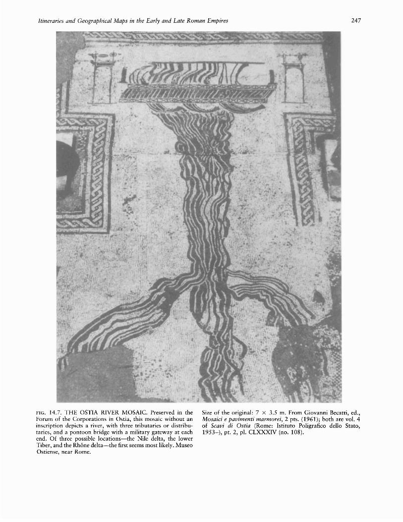
Although the mosaic map of Byzantine age at Madabahas appeared in many popular works on the history ofcartography, it is by no means the earliest map to occurin this medium. An example dating to the early empireis found in Ostia, associated with the many mosaic floorsthat have been preserved there in situ.?3 They are in the"Forum of the Corporations," next to the theater, whichhad a temple of Ceres in the middle and a series of officesbelonging to trading corporations around the sides.From the names of foreign ports within the mosaics itis possible to reconstruct many of Rome's trade routes.Only one of these mosaics is in map form, but unfortunately it has no inscription (fig. 14.7).74 It shows ariver spanned by a pontoon bridge, with three branchesthat could be either tributaries or distributaries. Thebridge is supported by three vessels, and on each side ofit is a gateway surmounted by military trophies. TheNile delta seems the most probable location. Anotheroffice in the same forum was occupied by an Alexandriancorporation, and corn imports from Egypt were considerable. If these two offices are linked, the likely interpretation is that the three principal ancient distributariesof the Nile are depicted, giving a more simplified version
Cartography in Ancient Europe and the Mediterranean
Diameter of the original: 3.5 cm. By permission of the Trusteesof the British Museum, London (BMC Emp.I, Nero 132).
of the delta than is to be seen in the Madaba mosaic.Since the pontoon bridge is above the lowest point onthe undivided river, one may conjecture that it was between Memphis, the dynastic capital, which was still ofsome importance under the Roman Empire, and Babylon(Old Cairo). The military trophies would be appropriateto Babylon, which was fortified as a legionary campunder Augustus, while Memphis was the center for theexport of wild animals from Egypt to Rome.?5
73. Giovanni Becatti, ed., Mosaici e pavimenti marmorei; 2 pts.(1961); both are vol. 4 of Scavi di Ostia (Rome: Istituto Poligraficodello Stato, 1953-).
74. Foro delle Corporazioni, Statio 27: Becatti, Mosaici, 74, no.108 and pI. CLXXXIV (note 73).
75. The mosaic at the temple of Fortuna Primigenia at Praeneste(Palestrina), central Italy, mentioned in chapter 7, note 4 above, alsogives a pictorial representation of scenes around the Nile. It has beengiven various dates but is perhaps of the second century A.D. Theinscriptions, in Greek capitals, specify typical Egyptian animals. Theattempt to show that it is a map in oblique perspective does not appealto most art historians, and it must remain in the sometimes debatableborderland between the completely pictorial and the partly cartographic. See references in Wilhelm Kubitschek, "Karten," in Realencyclopiidie, 10 (1919): cols. 2022-2149, esp. 2023 (note 13); Leviand Levi, Itineraria picta, 44 n. 65 (note 18). A black-and-white reproduction is found in Moses Hadas, Imperial Rome (Alexandria,Va.: Time-Life Books, 1979), 70-71. For the Alexandrian traditionof landscape painting, which may have influenced the Palestrina mosaicand others, see Roger Ling, "Studius and the Beginnings of RomanLandscape Painting," Journal ofRoman Studies 67 (1977): 1-16, withbibliography in note on p. 1, and p. 14 n. 53.
Itineraries and Geographical Maps in the Early and Late Roman Empires 247
FIG. 14.7. THE OSTIA RIVER MOSAIC. Preserved in theForum of the Corporations in Ostia, this mosaic without aninscription depicts a river, with three tributaries or distributaries, and a pontoon bridge with a military gateway at eachend. Of three possible locations-the Nile delta, the lowerTiber, and the Rhone delta-the first seems most likely. MuseoOstiense, near Rome.
Size of the original: 7 x 3.5 m. From Giovanni Becatti, ed.,Mosaici e pavimenti marmorei, 2 pts. (1961); both are vol. 4of Scavi di Ostia (Rome: Istituto Poligrafico dello Stato,1953-), pt. 2, pI. CLXXXIV (no. 108).

248
What have been recognized as maplike designs, inaddition to those of mazes described below, also occuroccasionally in mosaics dated to the late empire. Mosaicswith views of estates, one category of such images, canhardly be regarded even as picture maps: the most conspicuous is the fourth-century mosaic from Carthage,now in the Bardo Museum, Tunis, showing the estateof Julius.76 But one temple scene, also from Carthage,is represented partly in plan. This is a late fourth- orfifth-century mosaic known as the Offering of theCrane.77 In the center is a shrine facade with Apollo andDiana between two columns; at their feet is the sacrificialcrane, and below it a series of almost concentric squaresclearly representing the ground plan of this same shrine.
Some mosaics also contain celestial maps in the formof zodiac diagrams. The earliest Palestine zodiac mosaic,for example, thought to be of the third century A.D., isin the synagogue at Hammath, south of Tiberias.78 Itrepresents the twelve signs of the zodiac surrounding thesun, with personifications of the four seasons occupyingthe corners. The inspiration of this Hebrew mosaic isGreek, with the sun as Phoebus Apollo driving a fourhorse chariot, Virgo as a veiled Persephone carrying atorch, and Libra as a king, clearly Minos or Rhadamanthys, holding a scepter and balance. Other similarmosaics are of very much later date, when Palestine waspart of the Byzantine empire.
THE PESARO WIND ROSE MAP
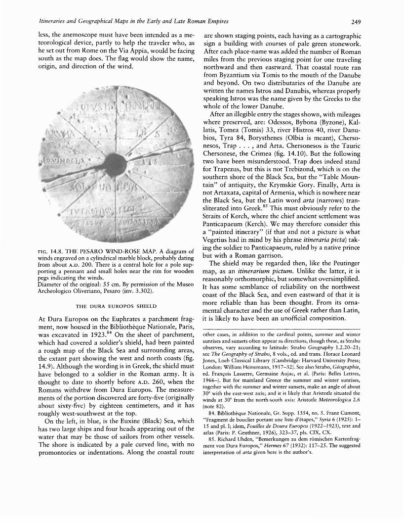
In some cases an unusual physical object carries a map,so that there is a temptation to describe it as "unique"in artifactual terms although its image may also be familiar from other sources. Such an object is the "Boscovich" anemoscope,79 a cylindrical block of Luna marble 55.3 centimeters in diameter and 6.8 centimeters inwidth, on which is engraved a wind rose map (fig.14.8).80 It was found near the Via Appia at Rome, outside the Porta Capena, in 1759. The name is inexact,since the astronomer R. G. Boscovich only helped theowner, P. M. Paciaudi, in his researches. Now in theOliveriano Museum at Pesaro, it is thought to date fromabout A.D. 200. It is inscribed Eutropius feci (I, Eutropius [a Greek name], made it).
To construct his wind rose map, Eutropius engraveda meridian, divided this equally into six, contrary toAristotle,81 and from the dividing points drew five linesat right angles to the meridian. These are labeled, indescending order: TOTVS INFRA TERRA(M) (the AntarcticCircle); BRVMALIS (the Tropic of Capricorn); AEQVI
NOCTIALIS (the equator); SOLI(S)TITIALIS (the Tropic ofCancer); and TOTVS SVPRA TERRA(M) (the Arctic Circle).At each end of the meridian and of each line are smallholes intended for bronze pegs. From these twelve holes,
Cartography in Ancient Europe and the Mediterranean
lines are drawn to the center, where a large depressionpresumably served to insert a metal base for the flag ofthe wind rose. On the rim, opposite the holes, are thenames of the twelve winds.
The scheme probably arose from a reading of thepassage from Aristotle mentioned above (pp. 145-46)without the benefit of a diagram.82 Aparcias (Aparctias,Septentrio) occupies a far larger sector than neighboringBoreas; the two are identical in Aristotle. This is notimportant, since in antiquity the number, names, anddirections of winds on a wind rose varied.83 Neverthe-
76. Very frequently reproduced: references in Levi and Levi, Itineraria picta, 68 n. 3 (note 18); Katherine M. D. Dunbabin, The Mosaicsof Roman North Africa: Studies in Iconography and Patronage (Oxford: Clarendon Press, 1978), 119-21, pI. 109.
77. Dunbabin, Mosaics, 57-58, pIs. 35-37 (note 76).78. Michael Avi-Yonah, Ancient Mosaics (London: Cassell, 1975),
51-53. For the difference in approach between Christian and Jewishmosaicists see Dunbabin, Mosaics, 232-33 and n. 174 (note 76), andfor the zodiac in North African mosaics see her Index IV, S.v. "Zodiac."
79. Italo Zicari, "L'anemoscopio Boscovich del Museo Oliverianodi Pesaro," Studia Oliveriana 2 (1954): 69-75; Robert Boker, "Windrosen," in Realencyclopadie, 2d ser., 8.2 (1958): cols. 2325-81, esp.2358-60 (note 13); Antonio Brancati, La biblioteca e i musei Oliveriani di Pesaro (Pesaro: Banca Popolare Pesarese, 1976), 210-11;Dilke, Greek and Roman Maps, 110-11 (note 4).
80. Wind rose maps are also found in textual sources. A wind rose,for example, is preserved in the oldest manuscript of Vitruvius Dearchitectura (note 33), in which it is the only illustration (1.6.4 ff.).In the text he says it is "so delineated that it is clear where windscome from": London, British Library, Harl. MS. 2767; see O. A. W.Dilke, Roman Books and Their Impact (Leeds: Elmete Press, 1977),26-27, quotation on 26. A possible parallel to the Boscovich anemoscope is a small Greek world map to be found in manuscripts ofthe scholia to Ptolemy's Handy Tables; see Otto Neugebauer, "AGreek World Map," in Le monde grec: Hommages aClaire Preaux,ed. Jean Bingen, Guy Cambier, and Georges Nachtergael (Brussels:Universite de Bruxelles, 1975), 312-17 and pI. III.2. The manuscriptsdate from the thirteenth century onward, but the map clearly originated under the Roman Empire, probably in Egypt, since it namescertain southerly places such as Syene (Aswan) and Hiera Sykaminos(above Syene on the Nile). These are places from which astronomicalobservations could be made. Ptolemy's instructions for making tableswere later worked up by Theon of Alexandria (fl. A.D. 364). Unlikethe anemoscope, this world map, which is in the form of a roughsketch, does not have lines linking the wind points to the center. Itmay go back to an archetype earlier than Theon.
81. But a miniature in a manuscript of Aristotle's Meteorologica atthe Royal Library in Madrid makes the spacing of the zones rathereven by attaching lines to small semicircles inscribed within theperimeter: Charles Graux and Albert Martin, "Figures tirees d'unmanuscrit des Meteorologiques d'Aristote," Revue de Philologie, deLitterature et d'Histoire Anciennes, n.s., 24 (1900): 5-18.
82. In modern reconstructions of Aristotle's diagram, four out offive of Eutropius's horizontal lines are visible, though not equallyspaced. Aristotle himself may have inserted only the diameters. Aristotle Meteorologica 2.6; see Meteorologica, trans. H. D. P. Lee, LoebClassical Library (Cambridge: Harvard University Press; London: William Heinemann, 1952).
83. Vitruvius De architectura 1.6.4 ff. (note 33), discussed four,eight, and sixteen winds, the last corresponding to Etruscan usage. In
Itineraries and Geographical Maps in the Early and Late Roman Empires 249
less, the anemoscope must have been intended as a meteorological device, partly to help the traveler who, ashe set out from Rome on the Via Appia, would be facingsouth as the map does. The flag would show the name,origin, and direction of the wind.
FIG. 14.8. THE PESARO WIND-ROSE MAP. A diagram ofwinds engraved on a cylindrical marble block, probably datingfrom about A.D. 200. There is a central hole for a pole supporting a pennant and small holes near the rim for woodenpegs indicating the winds.Diameter of the original: 55 em. By permission of the MuseoArcheologico Oliveriano, Pesaro (inv. 3.302).
THE DURA EUROPOS SHIELD
At Dura Europos on the Euphrates a parchment fragment, now housed in the Bibliotheque Nationale, Paris,was excavated in 1923.84 On the sheet of parchment,which had covered a soldier's shield, had been painteda rough map of the Black Sea and surrounding areas,the extant part showing the west and north coasts (fig.14.9). Although the wording is in Greek, the shield musthave belonged to a soldier in the Roman army. It isthought to date to shortly before A.D. 260, when theRomans withdrew from Dura Europos. The measurements of the portion discovered are forty-five (originallyabout sixty-five) by eighteen centimeters, and it hasroughly west-southwest at the top.
On the left, in blue, is the Euxine (Black) Sea, whichhas two large ships and four heads appearing out of thewater that may be those of sailors from other vessels.The shore is indicated by a pale curved line, with nopromontories or indentations. Along the coastal route
are shown staging points, each having as a cartographicsign a building with courses of pale green stonework.After each place-name was added the number of Romanmiles from the previous staging point for one travelingnorthward and then eastward. That coastal route ranfrom Byzantium via Tomis to the mouth of the Danubeand beyond. On two distributaries of the Danube arewritten the names Istros and Danubis, whereas properlyspeaking Istros was the name given by the Greeks to thewhole of the lower Danube.
After an illegible entry the stages shown, with mileageswhere preserved, are: Odessos, Bybona (Byzone), Kallatis, Tomea (Tomis) 33, river Histros 40, river Danubios, Tyra 84, Borysthenes (albia is meant), Chersonesos, Trap ... , and Arta. Chersonesos is the TauricChersonese, the Crimea (fig. 14.10). But the followingtwo have been misunderstood. Trap does indeed standfor Trapezus, but this is not Trebizond, which is on thesouthern shore of the Black Sea, but the "Table Mountain" of antiquity, the Krymskie Gory. Finally, Arta isnot Artaxata, capital of Armenia, which is nowhere nearthe Black Sea, but the Latin word arta (narrows) transliterated into Greek.85 This must obviously refer to theStraits of Kerch, where the chief ancient settlement wasPanticapaeum (Kerch). We may therefore consider thisa "painted itinerary" (if that and not a picture is whatVegetius had in mind by his phrase itineraria pieta) taking the soldier to Panticapaeum, ruled by a native princebut with a Roman garrison.
The shield may be regarded then, like the Peutingermap, as an itinerarium pietum. Unlike the latter, it isreasonably orthomorphic, but somewhat oversimplified.It has some semblance of reliability on the northwestcoast of the Black Sea, and even eastward of that it ismore reliable than has been thought. From its ornamental character and the use of Greek rather than Latin,it is likely to have been an unofficial composition.
other cases, in addition to the cardinal points, summer and wintersunrises and sunsets often appear as directions, though these, as Straboobserves, vary according to latitude: Strabo Geography 1.2.20-21;see The Geography of Strabo, 8 vols., ed. and trans. Horace LeonardJones, Loeb Classical Library (Cambridge: Harvard University Press;London: William Heinemann, 1917-32). See also Strabo, Geographie,ed. Fran<;ois Lasserre, Germaine Aujac, et al. (Paris: Belles Lettres,1966-). But for mainland Greece the summer and winter sunrises,together with the summer and winter sunsets, make an angle of about30° with the east-west axis; and it is likely that Aristotle situated thewinds at 30° from the north-south axis: Aristotle Meteorologica 2.6(note 82).
84. Bibliotheque Nationale, Gr. Supp. 1354, no. 5. Franz Cumont,"Fragment de bouclier portant une liste d'etapes," Syria 6 (1925): 115 and pI. I; idem, Fouilles de Doura Europos (1922-1923), text andatlas (Paris: P. Geuthner, 1926), 323-37, pis. CIX, CX.
85. Richard Uhden, "Bemerkungen zu dem romischen Kartenfragment von Dura Europos," Hermes 67 (1932): 117-25. The suggestedinterpretation of arta given here is the author's.

250 Cartography in Ancient Europe and the Mediterranean
FIG. 14.9. THE MAP ON THE DURA EUROPOS SHIELD.Dating to shortly before the Roman withdrawal from DuraEuropos in A.D. 260, this design was drawn upon parchmentfound covering a Roman soldier's shield. It shows the coastalroute from Byzantium to the mouth of the Danube and beyond,complete with the mileages between staging posts.
PLANS ON LAMPS
An unusual series of designs on Roman lamps, incorporating rudimentary plans, has been discovered in Palestine, probably datable to the early fourth centuryA.D.
86 One from Samaria (Sebastye) shows what appearsto be a Roman fort with rooms around the four sidesand with intersecting central roads (fig. 14.11). The correctness of the identification as a military diagram isshown by the emblem of two crossed swords on similarlamps from the same area. A fragmentary lamp from theOphel (near Jerusalem's Old City) appears to depict twoL-shaped Roman road stations, and other less certainlyidentifiable plans exist.87
CLASSICAL PLANS OF MAZES
The maps associated with the artifacts described aboveshow that they were adapted as motifs in a variety ofhistorical contexts. Such maps should be thought of asdifferent from, rather than historically less interestingthan, the formal maps of the textual sources. They reflectalternative ways of thinking about maps and confirmtheir more general acceptance within Roman society. Atthe same time, this evidence is important in showinghow some maps were recurrent motifs in the classicalworld. This is illustrated by a common category of clas-
Size of the original: 18 x ca. 65 em. Photograph from theBibliotheque Nationale, Paris (Gr. Suppl. 1354, no. 5).
o 100 200 miles
I----+--r'a 150 300 km
Dura Europos
FIG. 14.10. PRINCIPAL PLACE-NAMES FROM THE DURAEUROPOS SHIELD.
86. Mordechai Gichon, "The Plan of a Roman Camp Depicted upona Lamp from Samaria," Palestine Exploration Quarterly 104 (1972):38-58, who also illustrates the lamp from the Ophel.
87. Robert Alexander Stewart Macalister, The Excavation ofGezer,1902-1905 and 1907-1909, Palestine Exploration Fund, 3 vols. (London: John Murray, 1911-12), 3:pl. LXXII, 18.9: perhaps this depictsa barracks block.

Itineraries and Geographical Maps in the Early and Late Roman Empires 251
S em.I
FIG. 14.11. PLAN ON A ROMAN LAMP. Found at Samaria(Sebastye), in Palestine, and dating from the early fourth century A.D.. The illustration is a view from above.Size of the original: 6.5 X 8.9 x 3.2 cm. After MordechaiCichon, "The Plan of a Roman Camp Depicted upon a Lampfrom Samaria," Palestine Exploration Quarterly 104 (1972):38-58, esp. 39 (top).
sical map-the maze-that was associated with severalforms of emblematic representation.
The maze, or labyrinth, a feature well known fromdynastic Egypt and elsewhere, was particularly associated in classical antiquity with the palace of Minos atCnossos.88 Sir Arthur Evans thought it was connectedthere with the double ax (labrys) , and a maze patternappears on one of the wall frescoes of the palace.89 Thecity of Cnossos, proud of its Minoan heritage, mintedcoins in the classical period with rough plans of mazes,mostly having rectilinear paths, though the circular typealso exists (fig. 14.12).90 An early artifact showing oneis a clay tablet from the palace of Nestor at Pylos in thePeloponnese.91 On the reverse is a maze, thought to havebeen incised earlier than the obverse, that contains a listof ten men in the same Linear B script as occurs atCnossos. Another example from Greece is a tile of theclassical period from the acropolis at Athens, wherethere had much earlier been a Mycenaean stronghold.92
An Etruscan vase found at Tragliatella, near Rome,93shows among other features infantry performing a danceand cavalry next to a circular maze labeled TPVIA (Etruscan Truia = Troy). Here we have an allusion not merelyto an early palace but obviously to the "Game of Troy"that, whether rightly or wrongly attributed to that city,is described by Virgil as a Roman game having labyrinthine movements.94
FIG. 14.12. LABYRINTH DESIGNS ON CRETAN COINS.These silver coins show both a square maze (ca. 80 B.C.) anda rarer circular one (300-280 B.C.).Diameters of the originals: 2.3 cm and 3 cm respectively. Bypermission of the Trustees of the British Museum, London(BMC Cnossus 24 and 41).
88. "Labirinto," in Enciclopedia dell'arte antica, classica e orientale,7 vols. (Rome: Istituto della Encidopedia Italiana, 1958-66), W. H.Matthews, Mazes and Labyrinths: A General Account ofTheir Historyand Developments (London: Longman, 1922); Janet Bord, Mazes andLabyrinths of the World (London: Latimer New Dimensions, 1976);Karl Kerenyi, Labyrinth-Studien: Labryrinthos als Linienreflex einermythologischen Idee (Zurich: Rhein-Verlag, 1950).
89. Arthur Evans, The Palace ofMinos, 4 vols. (London: Macmillan,1921-35); Matthews, Mazes, 32, fig. 8 (note 88).
90. Jean N. Svoronos (Ioannes N. Sboronos), Numismatique de laCrete ancienne accompagnee de l'histoire, la geographie et la mythologie de l'Aile, text and plates published separately (Macon: Imprimerie Protat Freres, 1890; reprinted Bonn: R. Habelt, 1972), 65 H.and pIs. IV-VIII; Warwick Wroth, A Catalogue of the Greek Coinsof Crete and the Aegean Islands, ed. Reginald Stuart Poole (Bologna:A. Forni, 1963), 18-19, pis. 5 and 6; Matthews, Mazes, figs. 20-31(note 88).
91. Mabel Lang, "The Palace of Nestor Excavations of 1957: PartII," American Journal of Archaeology, 2d ser., 62 (1958): 181-91.The day tablet is Inventory Cn. 1287, discussed on p. 190 and picturedin pI. 46.
92. Ernst Buschor, Die Tondiicher der Akropolis (Berlin and Leipzig:Walter de Gruyter, 1929-33), 1.45 H., K 108; Hermann Kern, Labirinti: Forme e interpretazione, 5000 anni di presenza di un archetipomanuale e file conduttore (Milan: Feltrinelli, 1981), German ed., Labyrinthe: Erscheinungsformen und Deutungen, 5000 Jahre Gegenwarteines Urbilds (Munich: Prestel-Verlag, 1982).
93. Matthews, Mazes, figs. 133-35 and refs. (note 88).94. Virgil Aeneid 5.580 H.; see The Aeneid of Virgil, trans. Cecil
Day-Lewis (London: Hogarth Press, 1952).
252
One of the best-known Roman specimens is a graffitoat Pompeii showing a square mosaic with the wordingLABYRINTHUS: HIC HABITAT MINOTAURUS (Labyrinth:the Minotaur lives here), referring to the Cnossos palace.95 In fact the most common use of the motif in Roman times is in mosaics.96 One such is also at Pompeii,in the Villa di Diomede. Another particularly well preserved mosaic at Salzburg shows, in the center of asquare maze, Theseus about to kill the Minotaur. Thissame theme in the center of a circular maze, with recumbent towers at the corners, is found on a mosaic atCormerod, Switzerland.97 A partly preserved square mosaic, with a vase and scrolls surrounding the maze, wasfound in the churchyard of Caerleon (Isca).98 A lostspecimen from Sousse (Hadrumetum), Tunisia, includedTheseus's ship and the words HIC INCLUSUS VITAM PER
DIT (one enclosed here loses his life).99The early Christian use of maze mosaics can be ex
emplified from the fourth-century basilica of Saint Reparatus at al-A~nam, Algeria, where the center of thesquare maze has a play on words on SANCTA ECCLE
SIA.100 The classical tradition of maze plans continued
into the Middle Ages; the connection of the labyrinthwith Theseus and the Minotaur, sometimes then misinterpreted as a centaur, was not forgotten in medievalchurch ornamentation.
THE USE OF MAPS IN THE ROMAN PERIOD
Much has already been either said or implied about thewidespread use of maps in Roman society. There is moreevidence for the use of maps in the Roman period thanin other periods of antiquity, but the evidence is stilllargely fragmentary. Such evidence is partly from literaryor technical works and partly from inscriptions. It suggests that there was an expansion in the use of maps,even in periods that lacked marked technical or scientificadvances in mapmaking. Thus, as a conclusion to theperiod as a whole, an attempt is made here to classifythe uses of maps in Roman society, while accepting thatthere is clearly much overlap.
MAPS AS CADASTRAL AND LEGAL RECORDS
It was probably for land survey that Rome produced itsearliest working maps, one lost specimen (pp. 209-10)dating from the second century B.C. The Roman landsurvey treatises mention maps available both in Romeand locally; these were used among other purposes bylawyers (or surveyors experienced in land law) to contestproperty disputes, by emperors to decide boundary disputes between local authorities, and for levying centralor regional taxes. One object of depositing two copiesof survey maps, one in Rome and the other in a local
Cartography in Ancient Europe and the Mediterranean
office, was to save users unnecessary travel. The mapcame to be recognized as a legal document, both in landsurvey and for determining the use of aqueducts by property owners. Both writers on water supply, Vitruviusand Frontinus, show themselves familiar with maps: Vitruvius mentions river sources as painted and writtenabout in world cosmographies;101 for the use of aqueduct maps as mentioned by Frontinus, see page 232.
Another function of mapping is shared by religiousand legal or surveying aspects: often a tomb and surrounding plot were given their measurements on an inscription. An actual plan of these was only very rarelyattached. Such a plan could have helped lawyers in anydispute, such as about whether the land around a tombbelonged to the heirs. The users of the Forma UrbisRomae were on the one hand public organizations, onthe other hand private individuals living in Rome. Itseems unlikely that builders of new roads normally consulted maps, though there was a civil service maps department under the late empire.102
MAPS AS STRATEGIC DOCUMENTS
Contrary to Lloyd Brown's view, the story that a Phoenician captain was publicly rewarded for running hisship aground so as not to reveal to a following Romanship his route from Gades (Cadiz) to the Cassiteridesgives no indication of the use of maps.l03 It is thought
95. E. Pottier, "Labyrinthus," in Dictionnaire des antiquites grecques et romaines, 5 vols., ed. Charles Daremberg and Edmond Saglio(Paris: Hachette, 1877-1919), 3.2:882-83.
96. Pliny Natural History 36.19.85 (note 41) says one should notcompare the Cretan labyrinth to "our mosaic pavements or to themazes made in fields to amuse children"; author's translation.
97. C. Bursian, "Aventicum Helvetiorum," Mittheilungen der Antiquarischen Gesellschaft zu Zurich 16, no. 1 (1867-70), esp. pi. 29;Matthews, Mazes, fig. 36 (note 88).
98. George C. Boon, Isca: The Roman Legionary Fortress at Caerleon, Mon., 3d ed. (Cardiff: National Museum of Wales, 1972); Matthews, Mazes, 42 (note 88).
99. Salomon Reinach, Repertoire de peintures grecques et romaines(Paris: E. Leroux, 1922), 214.1, fig. 1.
100. Henri Leclercq, "Labyrinthe," in Dictionnaire d~archeologie
chretienne et de liturgie, 8.1 (1928): cols. 973-82, esp. 974-75 andfig. 6549 (note 17).
101. Vitruvius De architectura 8.2.6 (note 33).102. See p. 244 above and n. 68 of this chapter.103. The story is in Strabo Geography 3.5.11 (note 83). The Cas
siterides are called a group of islands, and their name is derived fromthe Greek word for tin; they are usually thought to have been theScilly Islands, but Rivet and Smith, Place-Names, 42-43 (note 9),prefer to place them outside the British Isles. Lloyd A. Brown, TheStory of Maps (Boston: Little, Brown, 1949; reprinted New York:Dover, 1979), 9, has a misleading account of this episode: in Strabothe sea captain is called Phoenician, not Carthaginian, and Strabo doesnot mention any ship's log or charts.
Itineraries and Geographical Maps in the Early and Late Roman Empires 253
to refer to the period between the First and Second PunicWars, 241-218 B.C. If Roman ships' captains wantedto consult a work that would help them navigate outsidethe Straits of Gibraltar, they could perhaps have turnedto the periplus of pseudo-Scylax (p. 383), though in theform in which it has come down to us it contains nothingon sea areas north of Cadiz.
The only extant admonition to the soldier to use mapsis in the late military writer Vegetius. Since, however,both Julius Caesar and Agrippa, the one a general, theother an admiral, were promoters of maps, there is goodreason to think that the use of these, as well as of itineraries and periploi (see "Maps for Traveling," below)was established relatively early.
The Augustan period was one in which, perhaps forthe first time in the Roman world, the use of maps bythe man in the street was taken for granted. Rough onescould be traced on the spot. The first poem of Ovid'sHeroides is supposedly a letter from Penelope to Ulysses,but typically the poet makes his Trojan heroes behavelike contemporaries. One such, who has reached homeafter the sack of Troy, describes the course of events ashe sketches the Troy area in wine on the table: "This iswhere the river Simois flowed; this is the land of Sigeum;here stood the high palace of old Priam; that is whereAchilles encamped, that is where Ulysses encamped; thisis the point where the mangling of Hector terrified thegalloping horses." 104 Propertius (ca. 50 B.C. to ca. 16B.C.) also uses the literary format of the letter, but froma Roman lady to her lover far away in the army. HisArethusa spends the winter nights studying maps: "Ilearn in what area the river Araxes, which is to be conquered, flows, how many miles the Parthian horse runswithout water. I compel myself to learn painted worldsfrom the map [tabula] ... ; which land freezes up, whichcrumbles from heat, which wind gives good sailing toItaly."105 Editors mostly treat tabula here as map ratherthan picture, though the expression may include both amap and its commentary.
The extent to which Roman expeditions carried mapsis open to dispute. If the word forma means "map" inseveral expedition accounts, both compilation and useare attested; but in any case there is at least one reference,and probably two, during the early empire to expeditionmaps sent back to Rome by commanders in the field. 106
The elder Pliny insists that the Caucasian Gates passshould be so called, not Caspian Gates. The mistake, hesays, arose in expeditions to the East by Domitius Corbulo between A.D. 58 and 63; and "maps of the area[situs] painted and sent home have this name drawn onthem.,,107 The other reference is also in Pliny and concerns a party of Praetorian guards who explored theupper Nile south of Khartoum. l08 Unfortunately theword forma is ambiguous, since it can mean either
"shape" or "map." If it is taken to be the latter, thesentence may be rendered: "The map of Ethiopia becameknown, as mentioned, and when recently brought to theemperor Nero it showed that for 996 miles from Syene,the boundary of the empire, to Meroe there were fewtrees and that all of these were species of palm."109 Sincetrees were often drawn on maps, though sometimes incorrect species, palms may have been drawn in as far asSyene and their dearth deduced from the appearance ofvery few upstream from there.
Such maps are likely to have been drawn by militarysurveyors but used with caution by strategists back inRome. Certainly, by the second century A.D., educatedRomans were becoming aware of the limitations of mapsas a basis for action on the fringes of unexplored territory. Thus Plutarch (ca. A.D. 46 to after 120) dedicateshis Parallel Lives to Sosius Senecio, consul four timesbetween A.D. 98 and 107, with this simile: "Just as historians, Sosius Senecio, in their geographies squeeze ontothe edges of their maps [pinakes] parts of the earth thatescape their knowledge, with notes explaining 'Everything beyond is sandy desert with no water or full ofwild animals' or 'unexplored marsh' or 'Scythian frost'or 'frozen sea,' so in writing my Lives ... I might aswell say of prehistory: 'Everything beyond is full of wonders.' ,,110
Such references suggest that the value of maps to thestate and its generals was widely accepted. Together withcoins and such monuments as Trajan's column, with itsgraphic representation of Rome's campaigns on the Danube, they could have had great propaganda value. Butthere were possible dangers also to an autocracy fromknowledge that could be extracted from maps by movements hostile to the imperial system, so that in the wronghands they could become a threat to security. Domitian,emperor from A.D. 81 to 96, was by nature autocratic,and knowing of previous conspiracies he was quick to
104. Ovid Heroides 1.33 ff., author's translation; see Heroides [and]Amores, trans. Grant Showerman, Loeb Classical Library (Cambridge:Harvard University Press; London: William Heinemann, 1958); cf.Tibullus Elegies 1.10.29-32; see Elegies, trans. Guy Lee, LiverpoolLatin Texts 3, 2d ed. (Liverpool: Francis Cairns, 1982).
105. Propertius Elegies 4.3.33-40, author's translation; see Propertius, trans. H. E. Butler, Loeb Classical Library (Cambridge: Harvard University Press; London: William Heinemann, 1912).
106. Robert K. Sherk, "Roman Geographical Exploration and Military Maps," in Aufstieg und Niedergang dey romischen Welt, ed.Hildegard Temporini (Berlin: Walter de Gruyter, 1972-),2.1 (1974):534-62, esp. 537-43.
107. Pliny Natural History 6.15.40 (note 41), author's translation.108. Pliny Natural History 6.35.181 (note 41).109. Pliny Natural History 12.8.19 (note 41), author's translation.110. Plutarch Theseus 1.1; cf. Christian Jacob, "Lectures antiques
de la carte," Etudes Fran~aises 21.2 (1985): 21-46, esp. 44-45.
254
suppress any hint of one against himself. Mettius Pompusianus was put to death by Domitian because, in addition to being born under an imperial constellation andgiving Carthaginian generals' names to his slaves, hecarried around a parchment map of the world, togetherwith speeches of kings and generals from Livy.lll Thiswas a period when parchment was increasing in use asagainst papyrus;112 it was certainly more transportable.Suspicious of spies, Domitian may have linked the mapwith fears of an uprising in North Africa; in an expandedempire there was plenty of scope for rebellion.
MAPS FOR TRAVELING
Ptolemy's Geography, with its tables of coordinates, wasnever intended for the traveler; but there is reason tothink that the latitudes of Roman provinces on the reverse of portable sundials were indebted to Ptolemy, andthese sundials were used by travelers and surveyors.
Itineraries for land journeys and simple periploi forsea journeys were also commonly used. A governor suchas Arrian, second century A.D. (who was also a man ofletters), chose to compile an expanded periplus for hissail around the Black Sea. This may have appeared inLatin for official purposes as well as in Greek for hisreading public.113 Whether it was based on a map wecannot be sure, but the Dura Europos shield proves thatat least road maps of that area existed. It is also difficultto establish how far land itineraries were derived frommaps; since road maps are called by Vegetius itinerariapieta, painted itineraries, the priority may be the otherway around. The most famous are the Antonine landand sea itineraries (pp. 235-36). These are not representative of the type carried around by the travelingpublic. They obviously detailed particular journeys madeby people like the emperor Caracalla, whereas othertravelers might want only a section of these. AmongChristian itineraries, that of the journey from Bordeauxto Jerusalem (p. 237), by expanding on the basic listform, was designed to help the pilgrim traveling to theHoly Land.
Clearly anyone making a complicated road journeywould have benefited from having an itinerarium pictumlike the archetype of the Peutinger map. But ancientmaps may not have stood up very well to travel, sincethey would normally be carried around loose, not in aeapsa (cylindrical box), used for storing rolls of papyrusin the owner's house. Perhaps, however, the increasinguse of parchment started to promote a greater mobilityof maps in the late empire. Julian the Apostate, emperor360-63, thanks his friend Alypius of Antioch thus: "Ihappened already to have recovered from my illnesswhen you sent the geography; all the same I was gladto receive the map you sent. Not only does it have better
Cartography in Ancient Europe and the Mediterranean
drawings [diagrammata] than previous ones, but youhave made it more attractive by adding iambicverses.,,114 This may have been a map of Britain, sinceAlypius was or had been viearius of the British provinces.The Greek verses remind us of the Latin ones attachedto the Theodosian map (see below, pp. 258-59).
RELIGIOUS AND PROPAGANDA FUNCTIONS FOR MAPS
One of the first Roman maps we hear of, the 174 B.C.
map of Sardinia (p. 205), served both as a form ofthanksgiving to the gods for victory and as a useful pieceof propaganda showing Rome's expansion, just as Mussolini displayed maps of the Roman empire. Mosaics atOstia (pp. 246-47) advertised a shipping corporation orthe transport guild. A somewhat different element ofpublic relations is visible in the chief Christian map ofthe early Byzantine period, the Madaba map (pp. 26365), where Jerusalem is given specially enlarged and detailed treatment; the map was oriented so as to be easilyseen by the congregation.
DIDACTIC AND SCHOLARLY USES FOR MAPS
It is clear from Varro that at least the more progressivelandowners in Italy were regarded as being familiar withthe use of maps. Both he and the elder Pliny were encyclopedic writers who absorbed vast quantities ofGreek scholarly exposition. Varro mayor may not havecited sources (his encyclopedic writing exists only infragments). Pliny, in book 1, lists all his sources andthereafter frequently refers to them, but often in such away that he does not tell us whether he is referring toa text or a map. Thus for the circumference of the BlackSea, apart from Agrippa's map and commentary (whichhe calls simply Agrippa), he cites four estimates, datingfrom about 50 B.C. to about A.D. 70, all of which maycome from texts rather than maps. In the case of lengthsof the shores of the Red Sea, his object seems to have
111. Suetonius Domitian 10.3, book 8 of De vita Caesarum (Thelives of the Caesars), in Suetonius, 2 vols., trans. J. C. Rolfe, LoebClassical Library (Cambridge: Harvard University Press; London: William Heinemann, 1913-14). Pascal Arnaud, "L'affaire Mettius Pompusianus, ou Le crime de cartographie," Melanges de tEcole Fran{aisede Rome: Antiquite 95 (1983): 677-99, prefers to follow the accountof Dio Cassius and Zonaras. According to this, Pompusianus had aworld map painted on the walls of his bedroom. See Dio CassiusRoman History 67.12.4 (note 7).
112. C. H. Roberts, "The Codex," Proceedings of the British Academy 40 (1954): 169-204.
113. Arrian Periplus Ponti Euxini, in Miiller, Geographi Graeciminores, 1:370-423 (note 20).
114. Julian Epistles 7, author's translation; see vol. 3 of The Worksof the Emperor Julian, 3 vols., trans. Wilmer Cave Wright, LoebClassical Library (Cambridge: Harvard University Press; London: William Heinemann, 1913-23).

Itineraries and Geographical Maps in the Early and Late Roman Empires 255
been to correct the mapping by Eratosthenes with references to the much higher figures given by Artemidorusof Ephesus (fl. 104-101 B.C.) and by Agrippa. Varrohad illustrations in some of his works, but none hassurvived; Pliny is not known to have had any. After Plinywe have no extant encyclopedias until the fifth centuryA.D. and later (Martianus Capella, Boethius, and Isidore); of these only Isidore, bishop of Seville A.D. 60236, dealt specifically with geography.115
Of purely geographical Latin writings, the lost commentary of Agrippa was intended (as the many fragments show) to explain his map; it would appeal mainlyto those, including Strabo and Pliny, who visited hiscolonnade. Pomponius Mela's De chorographia was designed for the ordinary reading public and had no maps.But the writer probably had one before his eyes when,for example, he writes of the Baltic: "The Codanus Gulf... is dotted with large and small islands.,,116
An interesting insight into the teaching of geographywith the use of a terrestrial globe is found in a pupil'saddendum to the Cosmographia of Julius Honorius: "Soas to avoid errors, as the teacher has said, this book ofextracts should not be separated from the globe."11? Theuse of the map in schools continued after the fall ofRome: Cassiodorus (ca. A.D. 490 to ca. 583), who aftermany years as an important administrator under kingsof the Goths in Italy devoted himself to Christianity andeducation, recommended for teaching purposes thepinax (map) accompanying the geographical poem ofDionysius Periegetes. 118 In addition to maps in schools,the words quoted from the rhetorician Eumenius showthat, in Gaul of A.D. 298 at least, an idealist wanting tofoster culture among the young after the ravages of warincluded a large map on a balcony wall as an importantteaching aid.
Mapmaking clearly constituted an essential part ofthe training of land surveyors under the late RomanEmpire. First and foremost was drawing up centuriationmaps, which, although to some extent diagrammatic,had to be very accurate from the legal and administrativepoint of view. For this purpose apprentice surveyorswould consult the official copies; yet in the Corpus Agrimensorum we find some maps that are unrealistic intopographical terms. This must represent a tradition ofdecades of specimen teaching maps, in which topographical accuracy and the representation of real landscapeswere of secondary importance.
It must, however, be admitted that educated Romans,although they respected Greek scientific research, didnot always understand the mathematical principles behind it. We do know that about 168 B.C. Crates ofMallos gave many lectures in Rome, illustrated by aglobe (see description above, pp. 162-64). Even so, hisglobe is reported not in extant Latin writings of the
republic but in the Greek geography of Strabo. Astronomical and mathematical instruments were introduced into Rome as contacts with the Greek world increased. But it often took a long time for the proper useof an instrument to be appreciated, as in the case of thesundial. In 263 B.C. one such was brought from Catanato Rome, where it was set up near the speakers' platformin the forum. Nevertheless, for ninety-nine years it displayed the wrong time, since the necessary adjustmentfor a different latitude had not been made: only in 164B.C. did Q. Marcius Philippus put up by its side a sundialcorrect for the latitude of Rome. 119 Lucretius was exceptional in expounding Greek physical theory in Latinverse. Cicero's contribution of this type consisted onlyof a translation of the Phaenomena of Aratus of Soli (b.ca. 315 B.C.), a meteorological work. He did promisehis friend Atticus a work on geography, but thoughAtticus sent him, evidently for this purpose, a work ofmathematical geography by Serapion, it never materialized;120 Cicero, in thanking him, commented, "Between ourselves, I hardly understand one line in a thousand." 121 This is not, however, to say that Cicero neverconsulted maps; he probably did in at least one case.When Atticus criticizes him for having written that almost all the city-states of the Peloponnese were by thesea,122 he replies that he got this from the tabulae ofDicaearchus.123 Since he goes on to refer to Dicaearchus's work on the underground oracle of Trophonius,
115. Isidore of Seville Etymologies; see Etymologiarum sive originum libri XX, 2 vols., ed. W. M. Lindsay (Oxford: Clarendon Press,1911); idem, De natura rerum, in Traite de la nature, ed. JacquesFontaine, Bibliotheque de l'Ecole des Hautes Etudes Hispaniques, fasc.28 (Bordeaux: Feret, 1960), 164-327.
116. Pomponius Mela De chorographia 3.31 (note 40), author'stranslation.
117. Julius Honorius Excerpta 50 (note 60), author's translation.118. Cassiodorus lnstitutiones divinarum et saecularium litterarum
1.25.2; see Institutiones, ed. R. A. B. Mynors (Oxford: ClarendonPress, 1937), or, for an English translation, An Introduction to Divineand Human Readings, ed. and trans. Leslie Webber Jones (New York:Columbia University Press, 1946). For Dionysius Periegetes, see pp.171-73.
119. Pliny Natural History 7.60.214; see corresponding notes inSchilling, Histoire naturelle, 261-62, esp. n. 214.3 (note 41). Therewas a dispute even in antiquity whether this was the earliest sundialerected in a public place in Rome: one of 293 B.C. is also mentionedby Pliny (Natural History 7.60.213); again, see Schilling, 261, n.213.1. Cf. Censorinus De die natali 23.6-7 (cited by Schilling) in Dedie natali liber, ed. F. Hultsch (Leipzig: Teubner, 1867).
120. Cicero Letters to Atticus 2.4.3; see Cicero's Letters to Atticus,7 vols., ed. and trans. D. R. Shackleton Bailey (Cambridge: CambridgeUniversity Press, 1965-70).
121. Cicero Letters to Atticus 2.4.1 (note 120).122. Cicero The Republic 2.4.8; see La republique, 2 vols., trans.
Esther Breguet (Paris: Belles Lettres, 1980).123. Cicero Letters to Atticus 6.2 (note 120).

256
the latest editor, Shackleton Bailey, doubts whether thesetabulae were maps124; but Cicero is probably referringto Dicaearchus's lost Ges periodos, a "geographicaltour" of the world.
In general it may be concluded that, as far as we knowat present, up to about 170 B.C. maps were relativelyunfamiliar to most Romans. From that time onwardtheir use steadily increased. By the time of Julius Caesar
BIBLIOGRAPHYCHAPTER 14 ITINERARIES AND GEOGRAPHICAL MAPS
IN THE EARLY AND LATE ROMAN EMPIRE
Avienius. Ora maritima. Edited by Andre Berthelot. Paris: H.Champion, 1934.
Boker, Robert. "Windrosen." In Paulys Realencyclopadie derclassischen Altertumswissenschaft, ed. August Pauly, GeorgWissowa, et aI., 2d ser., 8.2 (1958): cols. 2325-81. Stuttgart:J. B. Metzler, 1894-.
Bosio, Luciano. La Tabula Peutingeriana: Una descrizione pittorica del mondo antico. I Monumenti dell'Arte Classica,vol. 2. Rimini: Maggioli, 1983.
Carmody, F. J. La Gaule des itineraires romains. Berkeley:Carmody, 1977.
Castagnoli, Ferdinando. "L'orientamento nella cartografiagreca e romana." Rendiconti della Ponti{icia Accademia Romana di Archeologia 48 (1975-76): 59-69.
Clemente, G. La Notitia Dignitatum. Saggi di Storia e Letteratura 4. Cagliari: Fossataro, 1968.
Cartography in Ancient Europe and the Mediterranean
or Augustus they were used by a wide range of people,had become indispensable for the surveying of land, public works, and other engineering projects, and were important for legal, strategic, traveling, scholarly, and didactic purposes.
124. Shackleton Bailey, Cicero's Letters, 3:257 (note 120).
Cumont, Franz. "Fragment de bouclier portant une listed'etapes." Syria 6 (1925): 1-15.
Cuntz, Otto, ed. Itineraria Romana. Vol. 1, Itineraria AntoniniAugusti et Burdigalense. Leipzig: Teubner, 1929.
Dilke, O. A. W. Greek and Roman Maps. London: Thamesand Hudson, 1985.
Elter, A. Itinerarstudien. Bonn: C. Georgi, 1908.Finkelstein, 1. "The Holy Land in the Tabula Peutingeriana."
Palestine Exploration Quarterly 111 (1979): 27-34.Frank, Johannes. "Beitrage zur geographischen ErkHirung der
Ora maritima Aviens." Dissertation, Wiirzburg. Sangerhausen: Schneider, 1913.
Gichon, Mordechai. "The Plan of a Roman Camp Depictedupon a Lamp from Samaria." Palestine Exploration Quarterly 104 (1972): 38-58.
Goodburn, R., and P. Bartholomew, eds. Aspects ofthe NotitiaDignitatum. British Archaeological Reports, SupplementarySeries 15. Oxford: British Archaeological Reports, 1976.
Itineraries and Geographical Maps in the Early and Late Roman Empires 257
Gross, H. Zur Entstehungs-geschichte der Tabula Peutingeriana. Bonn: H. Ludwig, 1913.
Itineraria et alia geographica. In Corpus Christianorum, SeriesLatina, vols. 175 and 176 (1965).
Janni, Pietro. La mappa e il periplo: Cartografia antica e spazioodologico. Universita di Macerata, Pubblicazioni della Facolta di Lettere e Filosofia 19. Rome: Bretschneider, 1984.
Kubitschek, Wilhelm. "Itinerarien." In Paulys Realencyclopadie der classischen Altertumswissenschaft, ed. AugustPauly, Georg Wissowa, et aI., vol. 9 (1916): cols. 2308-63.Stuttgart: J. B. Metzler, 1894-.
---. "Karten." In Paulys Realencyclopadie der classischenAltertumswissenschaft, ed. August Pauly, Georg Wissowa,et aI., vol. 10 (1919): cols. 2022-2149. Stuttgart: J. B. Metzler, 1894-.
Levi, Annalina, and Mario Levi. Itineraria picta: ContributoaUo studio della Tabula Peutingeriana. Rome: Erma di Bretschneider, 1967.
Maier, I. G. "The Giessen, Parma and Piacenza Codices of the'Notitia Dignitatum' with Some Related Texts." Latomus27 (1968): 96-141.
---. "The Barberinus and Munich Codices of the NotitiaDignitatum Omnium." Latomus 28 (1969): 960-1035.
Miller, Konrad. Itineraria Romana. Stuttgart: Strecker undSchroder, 1916.
---. Die Peutingersche Tafel. Stuttgart: F. A. Brockhaus,1962.
Pliny. Natural History. 10 vols. Translated by H. Rackham etal. Loeb Classical Library. Cambridge: Harvard UniversityPress; London: William Heinemann, 1940-63.
Polaschek, Erich. "Notitia Dignitatum." In Paulys Realencyclopadie der classischen Altertumswissenschaft, ed. AugustPauly, Georg Wissowa, et aI., 17.1 (1936): cols. 1077-116.Stuttgart: J. B. Metzler, 1894-.
Reed, N. "Pattern and Purpose in the Antonine Itinerary."American Journal of Philology 99 (1978): 228-54.
Riese, Alexander, ed. Geographi Latini minores. Heilbronn,1878; reprinted Hildesheim: Georg alms, 1964.
Rodwell, Warwick. "Milestones, Civic Territories and the Antonine Itinerary." Britannia 6 (1975): 76-101.
Seeck, Otto, ed. Notitia Dignitatum. Berlin: Weidmann, 1876;reprinted Frankfort: Minerva, 1962.
Stewart, Aubrey, trans. Itinerary from Bordeaux to Jerusalem:HThe Bordeaux Pilgrim." Palestine Pilgrims Text Society,vol. 1, no. 2. London: Palestine Exploration Fund, 1896.
Temporini, Hildegard, and Wolfgang Haase, eds. Aufstieg undNiedergang der romischen Welt. Berlin: Walter de Gruyter,1972-.
Uhden, Richard. "Bemerkungen zu dem romischen Kartenfragment von Dura Europos." Hermes 67 (1932): 117-25.
Van der Poel, Halsted B., et aI., eds. Corpus topographicumpompeianum. Part 5, Cartography. Rome: Edizionedell'Elefante, 1981.
Ward, J. H. "The British Sections of the Notitia Dignitatum:An Alternative Interpretation." Britannia 4 (1973): 253-63.
Weber, Ekkehard, ed. Tabula Peutingeriana: Codex Vindobonensis 324. Graz: Akademische Druck- und Verlagsanstalt, 1976.
Zicari, Italo. "L'anemoscopio Boscovich del Museo Oliverianodi Pesaro." Studia Oliveriana 2 (1954): 69-75.