
13 Geomorphic Responses to Dam Removal in the...
29
13 Geomorphic Responses to Dam Removal in the United States – a Two-Decade Perspective Jon J. Major, Amy E. East, Jim E. O’Connor, Gordon E. Grant, Andrew C. Wilcox, Christopher S. Magirl, Mathias J. Collins, and Desiree D. Tullos 13.1 Introduction In the past few decades there has been increasing popular and political momentum in the United States to remove dams. What began with removal of small dams impounding modest sediment volumes has progressed to removal of large dams impounding millions of cubic meters of sediment. The reasons for removal are varied, but commonly relate to diminished function, costly maintenance, concerns over safety, and to acknowledgment that dams impair fish passage and other ecosystem func- tions and services (e.g., Babbitt 2002; Poff and Hart 2002; O’Connor, Major, and Grant 2008; Service 2011; Lovett 2014). However, decisions to remove dams are clouded by uncertainties over potential environmental benefits and detriments of removal. Concerns and uncertainties surround sediment release especially (e.g., Downs et al. 2009). Although a number of small (<10 m tall) and a few tall (≥10 m) dams had been removed by the early 2000s (e.g., Bednarek 2001; Hart et al. 2002; Poff and Hart 2002; Pohl 2002, 2003; Bellmore et al. 2015, 2016), there were few detailed studies of geo- morphic responses to those removals from which to draw conclusive insights. As a result, hypotheses regarding potential geomorphic responses of river systems to dam removal in the 1990s and early 2000s were drawn largely from analogies and concepts of fluvial geomorphology (Doyle, Stanley, and Harbor 2002; Pizzuto 2002). Since then, newer physical and numerical models that simulate chan- nel evolution in reservoirs and downstream distributions of eroded sediment have sharpened insights on possible river responses (e.g., Cantelli et al. 2007; Cui and Wilcox 2008; Grant et al. 2008; Downs et al. 2009; Greimann 2013; Podolak and Wilcock 2013; Ferrer-Boix, Martín-Vide, and Parker 2014; Gartner, Magilligan, and Renshaw 2015). Furthermore, a number of detailed field studies have now examined responses to dam removal (Bellmore et al. 2015; Table 13.1). As a result of these more recent modeling and field studies, we are positioned to test the veracity of posited hypotheses regarding geo- morphic responses to dam removals. And as the number of post-removal field studies has grown, we can assess whether common responses have emerged. Understanding outcomes of dam removals has a broader context than simply helping dam owners and stakeholders make decisions. Better knowl- edge of how river systems respond to sediment pulses introduced by dam removals informs assess- ments of hazards from natural dam failures; sediment injections from natural processes such as landslides (Hoffman and Gabet 2007), wildfires (Shakesby and Doerr 2006), and volcanic eruptions 355 Gravel-Bed Rivers: Processes and Disasters, First Edition. Edited by Daizo Tsutsumi and Jonathan B. Laronne. © 2017 John Wiley & Sons Ltd. Published 2017 by John Wiley & Sons Ltd.
Transcript of 13 Geomorphic Responses to Dam Removal in the...
13
Geomorphic Responses to Dam Removal in the United States – aTwo-Decade PerspectiveJon J. Major, Amy E. East, Jim E. O’Connor, Gordon E. Grant, Andrew C. Wilcox, Christopher S. Magirl,Mathias J. Collins, and Desiree D. Tullos
13.1 Introduction
In the past few decades there has been increasing popular and political momentum in theUnited States to remove dams.What began with removal of small dams impounding modest sedimentvolumes has progressed to removal of large dams impounding millions of cubic meters of sediment.The reasons for removal are varied, but commonly relate to diminished function, costly maintenance,concerns over safety, and to acknowledgment that dams impair fish passage and other ecosystem func-tions and services (e.g., Babbitt 2002; Poff and Hart 2002; O’Connor, Major, and Grant 2008; Service2011; Lovett 2014). However, decisions to remove dams are clouded by uncertainties over potentialenvironmental benefits and detriments of removal. Concerns and uncertainties surround sedimentrelease especially (e.g., Downs et al. 2009). Although a number of small (<10 m tall) and a few tall(≥10m) dams had been removed by the early 2000s (e.g., Bednarek 2001; Hart et al. 2002; Poffand Hart 2002; Pohl 2002, 2003; Bellmore et al. 2015, 2016), there were few detailed studies of geo-morphic responses to those removals from which to draw conclusive insights. As a result, hypothesesregarding potential geomorphic responses of river systems to dam removal in the 1990s and early2000s were drawn largely from analogies and concepts of fluvial geomorphology (Doyle, Stanley,and Harbor 2002; Pizzuto 2002). Since then, newer physical and numerical models that simulate chan-nel evolution in reservoirs and downstream distributions of eroded sediment have sharpened insightson possible river responses (e.g., Cantelli et al. 2007; Cui and Wilcox 2008; Grant et al. 2008; Downset al. 2009; Greimann 2013; Podolak and Wilcock 2013; Ferrer-Boix, Martín-Vide, and Parker 2014;Gartner, Magilligan, and Renshaw 2015). Furthermore, a number of detailed field studies have nowexamined responses to dam removal (Bellmore et al. 2015; Table 13.1). As a result of thesemore recentmodeling and field studies, we are positioned to test the veracity of posited hypotheses regarding geo-morphic responses to dam removals. And as the number of post-removal field studies has grown, wecan assess whether common responses have emerged. Understanding outcomes of dam removals hasa broader context than simply helping dam owners and stakeholders make decisions. Better knowl-edge of how river systems respond to sediment pulses introduced by dam removals informs assess-ments of hazards from natural dam failures; sediment injections from natural processes such aslandslides (Hoffman and Gabet 2007), wildfires (Shakesby and Doerr 2006), and volcanic eruptions
355
Gravel-Bed Rivers: Processes and Disasters, First Edition. Edited by Daizo Tsutsumi and Jonathan B. Laronne.© 2017 John Wiley & Sons Ltd. Published 2017 by John Wiley & Sons Ltd.
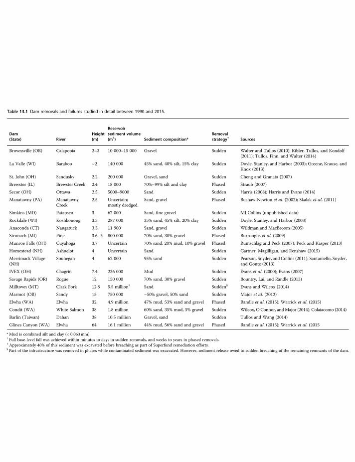
Table 13.1 Dam removals and failures studied in detail between 1990 and 2015.
Dam(State) River
Height(m)
Reservoirsediment volume(m3) Sediment composition*
Removalstrategy† Sources
Brownsville (OR) Calapooia 2–3 10 000–15 000 Gravel Sudden Walter and Tullos (2010); Kibler, Tullos, and Kondolf(2011); Tullos, Finn, and Walter (2014)
La Valle (WI) Baraboo ~2 140 000 45% sand, 40% silt, 15% clay Sudden Doyle, Stanley, and Harbor (2003); Greene, Krause, andKnox (2013)
St. John (OH) Sandusky 2.2 200 000 Gravel, sand Sudden Cheng and Granata (2007)
Brewster (IL) Brewster Creek 2.4 18 000 70%–99% silt and clay Phased Straub (2007)
Secor (OH) Ottawa 2.5 5000–9000 Sand Sudden Harris (2008); Harris and Evans (2014)
Manatawny (PA) ManatawnyCreek
2.5 Uncertain;mostly dredged
Sand, gravel Phased Bushaw-Newton et al. (2002); Skalak et al. (2011)
Simkins (MD) Patapsco 3 67 000 Sand, fine gravel Sudden MJ Collins (unpublished data)
Rockdale (WI) Koshkonong 3.3 287 000 35% sand, 45% silt, 20% clay Sudden Doyle, Stanley, and Harbor (2003)
Anaconda (CT) Naugatuck 3.3 11 900 Sand, gravel Sudden Wildman and MacBroom (2005)
Stronach (MI) Pine 3.6–5 800 000 70% sand, 30% gravel Phased Burroughs et al. (2009)
Munroe Falls (OH) Cuyahoga 3.7 Uncertain 70% sand, 20% mud, 10% gravel Phased Rumschlag and Peck (2007); Peck and Kasper (2013)
Homestead (NH) Ashuelot 4 Uncertain Sand Sudden Gartner, Magilligan, and Renshaw (2015)
Merrimack Village(NH)
Souhegan 4 62 000 95% sand Sudden Pearson, Snyder, and Collins (2011); Santaniello, Snyder,and Gontz (2013)
IVEX (OH) Chagrin 7.4 236 000 Mud Sudden Evans et al. (2000); Evans (2007)
Savage Rapids (OR) Rogue 12 150 000 70% sand, 30% gravel Sudden Bountry, Lai, and Randle (2013)
Milltown (MT) Clark Fork 12.8 5.5 million‡ Sand Sudden§ Evans and Wilcox (2014)
Marmot (OR) Sandy 15 750 000 ~50% gravel, 50% sand Sudden Major et al. (2012)
Elwha (WA) Elwha 32 4.9 million 47% mud, 53% sand and gravel Phased Randle et al. (2015); Warrick et al. (2015)
Condit (WA) White Salmon 38 1.8 million 60% sand, 35% mud, 5% gravel Sudden Wilcox, O’Connor, andMajor (2014); Colaiacomo (2014)
Barlin (Taiwan) Dahan 38 10.5 million Gravel, sand Sudden Tullos and Wang (2014)
Glines Canyon (WA) Elwha 64 16.1 million 44% mud, 56% sand and gravel Phased Randle et al. (2015); Warrick et al. (2015
*Mud is combined silt and clay (< 0.063mm).† Full base-level fall was achieved within minutes to days in sudden removals, and weeks to years in phased removals.‡Approximately 40% of this sediment was excavated before breaching as part of Superfund remediation efforts.§ Part of the infrastructure was removed in phases while contaminated sediment was excavated. However, sediment release owed to sudden breaching of the remaining remnants of the dam.
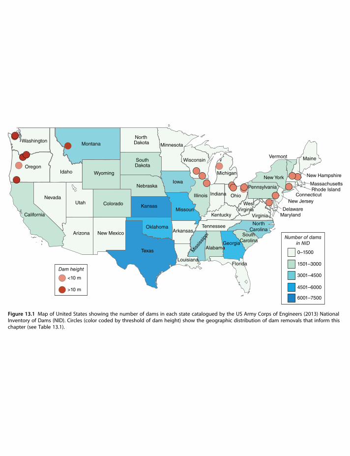
(Pierson and Major 2014); behavior of legacy sediment (James 2013; Merritts et al. 2013); and resto-ration activities such as gravel augmentation (Sklar et al. 2009).More than 87 000 dams taller than 1.8 m have been catalogued in the United States (Figure 13.1; US
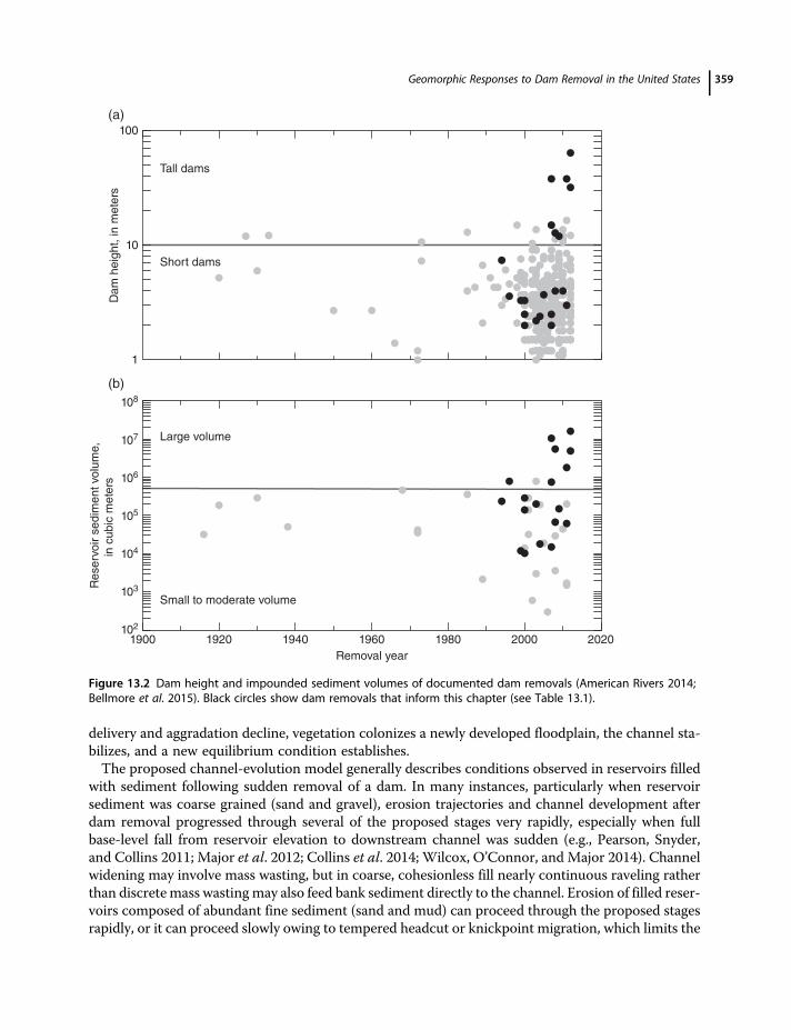
Army Corps of Engineers 2013), and more than 1100 have been removed intentionally – most since2000 (American Rivers 2014). Since the early 2000s, intentional dam removals and some unintentionalfailures have released varying magnitudes of diversely composed sediment to river systems. Removeddams have been as tall as 64 m (Figure 13.2a) and have impounded sediment volumes ranging from afew thousands to several millions of cubic meters (Figure 13.2b). Stored sediment compositions haveranged from predominantly mud (≤0.063mm) to predominantly gravel (Table 13.1). During someremovals, stored sediment was released abruptly when the full barrier height of a dam was breachedsuddenly; in others, sediment was released more slowly as base-level changed gradually during phasedremoval of a dam.Generally, effects of dam removals have been site specific, but an analysis of about 20 well-studied
removals (Table 13.1) reveals common patterns and controls on geomorphic response. The removalsexamined, however, are geographically limited. They are distributed unevenly, mostly in the northernand eastern United States, and all but one large-dam removals are in the Pacific Northwest(Figure 13.1). They are mainly run-of-river structures that passed water freely over their crests(Csiki and Rhoads 2010) or impounded small to moderate reservoir pools (≤30 million m3; Randleet al. 2015). Absent are removals of dams that stored very large volumes of water, that markedly alteredflow, or that impounded large volumes of mostly mud. Here, we discuss patterns of and controls ongeomorphic response within a contextual framework of volume and composition of stored reservoirsediment, style and rate of dam removal, processes eroding sediment from the reservoir upon dambreaching, and river hydrology during and after dam removal. Our analysis encompasses sandy alluvialand bedrock river systems in addition to those that are gravel-bedded. We conclude by summarizingcommon findings that have emerged from these studies.
13.2 Reservoir and Downstream Channel Responses to Dam Removal
Variations among physical settings, dam characteristics, and removal strategies have led to widelyvarying channel responses after removals. Common to most removals, however, is a coupled-systemresponse of reservoir erosion and downstream sediment transport and deposition. But the rates andprocesses by which this coupled system operates vary among settings.
13.2.1 Reservoir Erosion
Trajectories of reservoir erosion and channel development following dam removal have been positedto follow conceptual channel-evolution models describing response to base-level fall. Doyle, Stanley,and Harbor (2002) proposed a multistage model that describes a spatial and temporal evolutionarysequence in which channel initiation begins at the dam site and migrates upstream through thereservoir. Initially, a narrow channel starts incising after reservoir water has drained. Channel-incisionowing to headcut (a near-vertical step change in channel profile), knickpoint (a width-limited abruptinflection in channel profile), or knickzone (a nearly channel-spanning abrupt inflection in channelprofile) migration proceeds upstream. Channel widening owing to mass-wasting of channel banksfollows incision. An aggradational stage of development follows this degradational stage as upstreamerosion delivers and deposits abundant sediment to the downstream reach of reservoir. The aggrada-tional stage promotes continued channel widening, but at a diminishing rate. As rates of sediment
Geomorphic Responses to Dam Removal in the United States 357
OregonIdaho
Montana
Wyoming
NevadaUtah
Arizona
Colorado
New Mexico
Texas
Oklahoma
Kansas
Minnesota
Iowa
Wisconsin
Illinois
Michigan
Ohio
Kentucky
Tennessee
IndianaM
ississ
ippi
AlabamaGeorgia
SouthCarolina
NorthCarolina
Virginia
Pennsylvania
New York
Maine
New Hampshire
MassachusettsRhode Island
Connecticut
New Jersey
DelawareMaryland
Vermont
WestVirginia
Florida
Missouri
Arkansas
Louisiana
Nebraska
SouthDakota
NorthDakota
California
Washington
<10 m
>10 m
Dam height
0–1500
1501–3000
3001–4500
4501–6000
6001–7500
Number of damsin NID
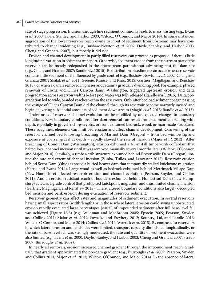
Figure 13.1 Map of United States showing the number of dams in each state catalogued by the US Army Corps of Engineers (2013) NationalInventory of Dams (NID). Circles (color coded by threshold of dam height) show the geographic distribution of dam removals that inform thischapter (see Table 13.1).
delivery and aggradation decline, vegetation colonizes a newly developed floodplain, the channel sta-bilizes, and a new equilibrium condition establishes.The proposed channel-evolution model generally describes conditions observed in reservoirs filled
with sediment following sudden removal of a dam. In many instances, particularly when reservoirsediment was coarse grained (sand and gravel), erosion trajectories and channel development afterdam removal progressed through several of the proposed stages very rapidly, especially when fullbase-level fall from reservoir elevation to downstream channel was sudden (e.g., Pearson, Snyder,and Collins 2011; Major et al. 2012; Collins et al. 2014; Wilcox, O’Connor, and Major 2014). Channelwidening may involve mass wasting, but in coarse, cohesionless fill nearly continuous raveling ratherthan discrete mass wastingmay also feed bank sediment directly to the channel. Erosion of filled reser-voirs composed of abundant fine sediment (sand and mud) can proceed through the proposed stagesrapidly, or it can proceed slowly owing to tempered headcut or knickpoint migration, which limits the
1
10
100
Dam
heig
ht, in m
ete
rs
Removal year
Reserv
oir s
edim
ent
volu
me,
in c
ubic
mete
rs
1900 1920 1940 1960 1980 2000 2020
Tall dams
Short dams
Large volume
Small to moderate volume
(a)
(b)
102
103
104
105
106
107
108
Figure 13.2 Dam height and impounded sediment volumes of documented dam removals (American Rivers 2014;Bellmore et al. 2015). Black circles show dam removals that inform this chapter (see Table 13.1).
Geomorphic Responses to Dam Removal in the United States 359
rate of stage progression. Incision through fine sediment commonly leads to mass wasting (e.g., Evanset al. 2000; Doyle, Stanley, and Harbor 2003; Wilcox, O’Connor, and Major 2014). In some instances,aggradation of the lower reservoir reach owing to input of sediment from upstream may have con-tributed to channel widening (e.g., Bushaw-Newton et al. 2002; Doyle, Stanley, and Harbor 2003;Cheng and Granata, 2007), but mostly it did not.Erosion and channel development in partly filled reservoirs can proceed as proposed if there is little
longitudinal variation in sediment transport. Otherwise, sediment eroded from the upstream part of thereservoir can be mostly redeposited in the downstream part without advancing past the dam site(e.g.,Cheng andGranata 2007;Randle et al. 2015). Redistributionof sediment canoccurwhena reservoircontains little sediment or is influenced by grade control (e.g., Bushaw-Newton et al. 2002; Cheng andGranata 2007; Skalak et al. 2011; Greene, Krause, and Knox 2013; Gartner, Magilligan, and Renshaw2015), or when a dam is removed in phases and retains a gradually dwindling pool. For example, phasedremovals of Elwha and Glines Canyon dams, Washington, triggered upstream erosion and deltaprogradation across reservoirwidths before poolwaterwas fully released (Randle et al., 2015).Delta pro-gradation led to wide, braided reaches within the reservoirs. Only after bedload sediment began passingthe vestige of Glines Canyon Dam did the channel through its reservoir become narrowly incised andbegin delivering substantial amounts of sediment downstream (Magirl et al. 2015; Randle et al. 2015).Trajectories of reservoir-channel evolution can be modified by unexpected changes in boundary
conditions. New boundary conditions after dam removal can result from sediment coarsening withdepth, especially in gravel-rich reservoirs, or from exhumed bedrock, wood, or man-made structures.These roughness elements can limit bed erosion and affect channel development. Coarsening of thereservoir channel bed following breaching of Marmot Dam (Oregon) – from bed winnowing andexposure of coarser gravel at depth – rapidly slowed the rate of incision (Major et al. 2012). Afterbreaching of Condit Dam (Washington), erosion exhumed a 4.5-m-tall timber-crib cofferdam thathalted local channel incision until it was removed manually several months later (Wilcox, O’Connor,and Major 2014). Similarly, a timber-crib structure exhumed behind Brownsville Dam (Oregon) lim-ited the rate and extent of channel incision (Zunka, Tullos, and Lancaster 2015). Reservoir erosionbehind Secor Dam (Ohio) exposed a buried beaver dam that temporarily stalled knickzone migration(Harris and Evans 2014). Large wood as well as bedrock exhumed behind Merrimack Village Dam(New Hampshire) affected reservoir erosion and channel evolution (Pearson, Snyder, and Collins2011). And an erosion-resistant reach of boulders exhumed behind Homestead Dam (New Hamp-shire) acted as a grade control that prohibited knickpoint migration, and thus limited channel incision(Gartner, Magilligan, and Renshaw 2015). There, altered boundary conditions also largely decoupledbed incision and bank erosion during evacuation of reservoir sediment.Reservoir geometry can affect rates and magnitudes of sediment evacuation. In several reservoirs
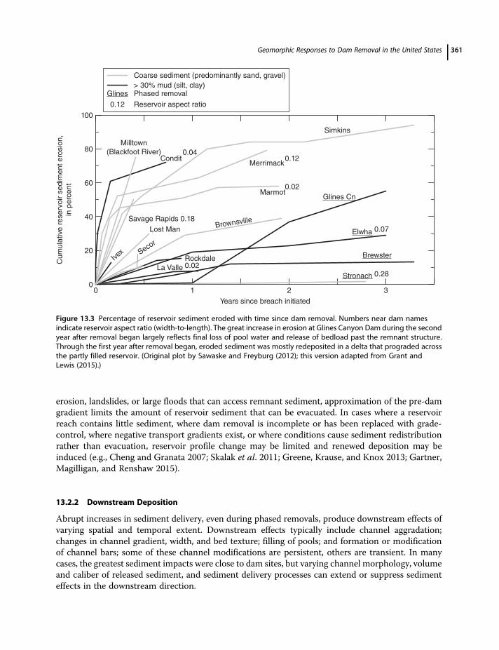
having small aspect ratios (width/length) or in those where lateral erosion could swing unobstructed,erosion rapidly evacuated large percentages (≥40%) of impounded sediment after full base-level fallwas achieved (Figure 13.3) (e.g., Wildman and MacBroom 2005; Epstein 2009; Pearson, Snyder,and Collins 2011; Major et al. 2012; Sawaske and Freyberg 2012; Bountry, Lai, and Randle 2013;Wilcox, O’Connor, andMajor 2014; Collins et al. 2014;Warrick et al. 2015). By contrast, for reservoirsin which lateral erosion and landslides were limited, transport capacity diminished longitudinally, orthe rate of base-level fall was strongly moderated, the rate and quantity of sediment evacuation werealso limited (e.g., Evans et al. 2000; Doyle, Stanley, and Harbor 2003; Cheng and Granata 2007; Straub2007; Burroughs et al. 2009).In nearly all removals, erosion increased channel gradient through the impoundment reach. Grad-
ually that gradient approximated the pre-dam gradient (e.g., Burroughs et al. 2009; Pearson, Snyder,and Collins 2011; Major et al. 2012; Wilcox, O’Connor, and Major 2014). In the absence of lateral
Gravel-Bed Rivers: Processes and Disasters360
erosion, landslides, or large floods that can access remnant sediment, approximation of the pre-damgradient limits the amount of reservoir sediment that can be evacuated. In cases where a reservoirreach contains little sediment, where dam removal is incomplete or has been replaced with grade-control, where negative transport gradients exist, or where conditions cause sediment redistributionrather than evacuation, reservoir profile change may be limited and renewed deposition may beinduced (e.g., Cheng and Granata 2007; Skalak et al. 2011; Greene, Krause, and Knox 2013; Gartner,Magilligan, and Renshaw 2015).
13.2.2 Downstream Deposition
Abrupt increases in sediment delivery, even during phased removals, produce downstream effects ofvarying spatial and temporal extent. Downstream effects typically include channel aggradation;changes in channel gradient, width, and bed texture; filling of pools; and formation or modificationof channel bars; some of these channel modifications are persistent, others are transient. In manycases, the greatest sediment impacts were close to dam sites, but varying channel morphology, volumeand caliber of released sediment, and sediment delivery processes can extend or suppress sedimenteffects in the downstream direction.
3210
Years since breach initiated
0
20
40
60
80
100
Cum
ula
tive
reserv
oir s
edim
ent ero
sio
n,
in p
erc
ent
La Valle
Rockdale Brewster
Merrimack
Marmot
Condit
Stronach
Ivex Seco
r
Savage Rapids 0.18
Glines Cn
Brownsville
Simkins
Lost Man
0.040.12
0.02
0.07
0.280.02
Milltown(Blackfoot River)
Coarse sediment (predominantly sand, gravel)
> 30% mud (silt, clay)Glines Phased removal
0.12 Reservoir aspect ratio
Elwha
Figure 13.3 Percentage of reservoir sediment eroded with time since dam removal. Numbers near dam namesindicate reservoir aspect ratio (width-to-length). The great increase in erosion at Glines Canyon Dam during the secondyear after removal began largely reflects final loss of pool water and release of bedload past the remnant structure.Through the first year after removal began, eroded sediment was mostly redeposited in a delta that prograded acrossthe partly filled reservoir. (Original plot by Sawaske and Freyburg (2012); this version adapted from Grant andLewis (2015).)
Geomorphic Responses to Dam Removal in the United States 361
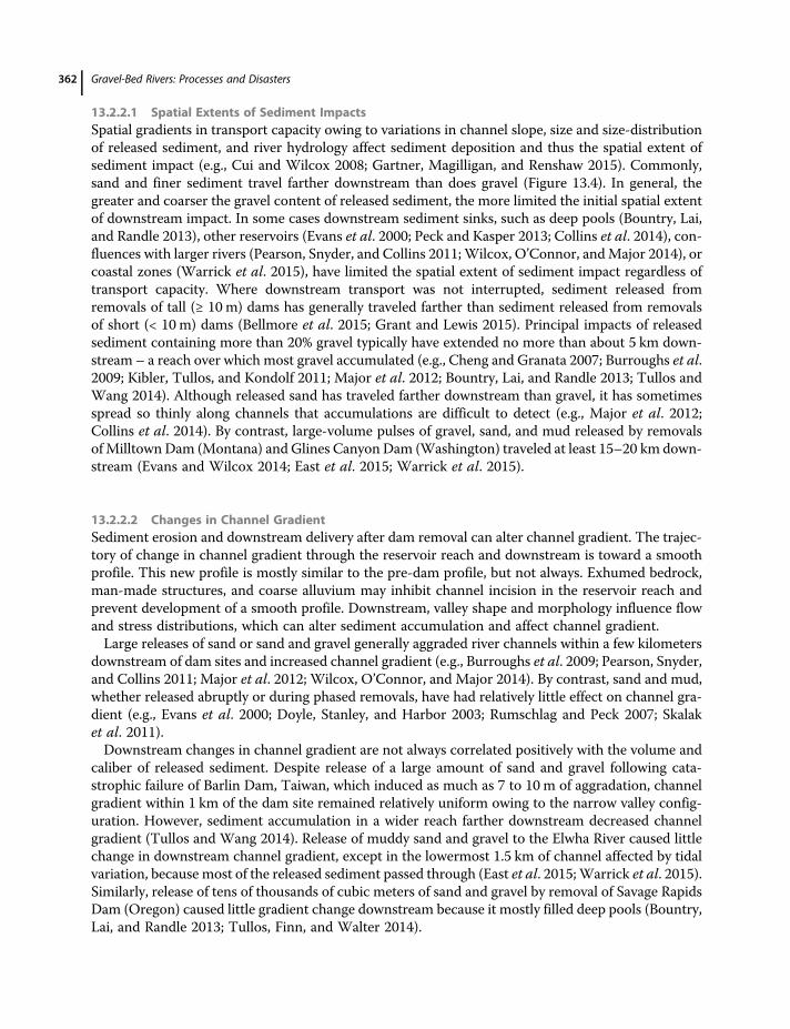
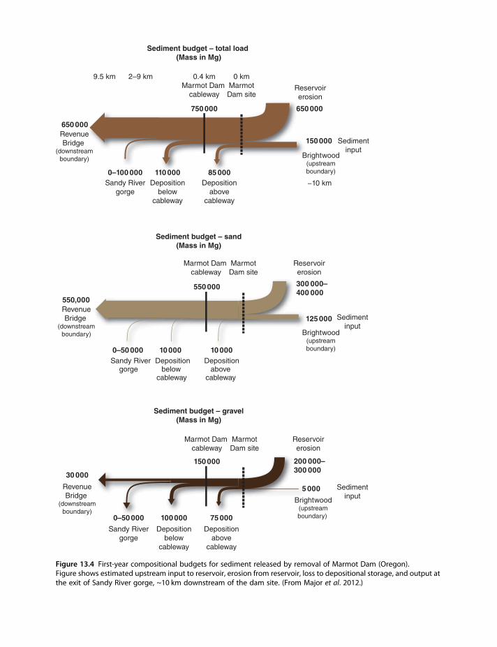
13.2.2.1 Spatial Extents of Sediment ImpactsSpatial gradients in transport capacity owing to variations in channel slope, size and size-distributionof released sediment, and river hydrology affect sediment deposition and thus the spatial extent ofsediment impact (e.g., Cui and Wilcox 2008; Gartner, Magilligan, and Renshaw 2015). Commonly,sand and finer sediment travel farther downstream than does gravel (Figure 13.4). In general, thegreater and coarser the gravel content of released sediment, the more limited the initial spatial extentof downstream impact. In some cases downstream sediment sinks, such as deep pools (Bountry, Lai,and Randle 2013), other reservoirs (Evans et al. 2000; Peck and Kasper 2013; Collins et al. 2014), con-fluences with larger rivers (Pearson, Snyder, and Collins 2011;Wilcox, O’Connor, andMajor 2014), orcoastal zones (Warrick et al. 2015), have limited the spatial extent of sediment impact regardless oftransport capacity. Where downstream transport was not interrupted, sediment released fromremovals of tall (≥ 10 m) dams has generally traveled farther than sediment released from removalsof short (< 10 m) dams (Bellmore et al. 2015; Grant and Lewis 2015). Principal impacts of releasedsediment containing more than 20% gravel typically have extended no more than about 5 km down-stream – a reach over which most gravel accumulated (e.g., Cheng and Granata 2007; Burroughs et al.2009; Kibler, Tullos, and Kondolf 2011; Major et al. 2012; Bountry, Lai, and Randle 2013; Tullos andWang 2014). Although released sand has traveled farther downstream than gravel, it has sometimesspread so thinly along channels that accumulations are difficult to detect (e.g., Major et al. 2012;Collins et al. 2014). By contrast, large-volume pulses of gravel, sand, and mud released by removalsofMilltown Dam (Montana) and Glines Canyon Dam (Washington) traveled at least 15–20 km down-stream (Evans and Wilcox 2014; East et al. 2015; Warrick et al. 2015).
13.2.2.2 Changes in Channel GradientSediment erosion and downstream delivery after dam removal can alter channel gradient. The trajec-tory of change in channel gradient through the reservoir reach and downstream is toward a smoothprofile. This new profile is mostly similar to the pre-dam profile, but not always. Exhumed bedrock,man-made structures, and coarse alluvium may inhibit channel incision in the reservoir reach andprevent development of a smooth profile. Downstream, valley shape and morphology influence flowand stress distributions, which can alter sediment accumulation and affect channel gradient.Large releases of sand or sand and gravel generally aggraded river channels within a few kilometers
downstream of dam sites and increased channel gradient (e.g., Burroughs et al. 2009; Pearson, Snyder,and Collins 2011; Major et al. 2012; Wilcox, O’Connor, and Major 2014). By contrast, sand and mud,whether released abruptly or during phased removals, have had relatively little effect on channel gra-dient (e.g., Evans et al. 2000; Doyle, Stanley, and Harbor 2003; Rumschlag and Peck 2007; Skalaket al. 2011).Downstream changes in channel gradient are not always correlated positively with the volume and
caliber of released sediment. Despite release of a large amount of sand and gravel following cata-strophic failure of Barlin Dam, Taiwan, which induced as much as 7 to 10 m of aggradation, channelgradient within 1 km of the dam site remained relatively uniform owing to the narrow valley config-uration. However, sediment accumulation in a wider reach farther downstream decreased channelgradient (Tullos and Wang 2014). Release of muddy sand and gravel to the Elwha River caused littlechange in downstream channel gradient, except in the lowermost 1.5 km of channel affected by tidalvariation, because most of the released sediment passed through (East et al. 2015;Warrick et al. 2015).Similarly, release of tens of thousands of cubic meters of sand and gravel by removal of Savage RapidsDam (Oregon) caused little gradient change downstream because it mostly filled deep pools (Bountry,Lai, and Randle 2013; Tullos, Finn, and Walter 2014).
Gravel-Bed Rivers: Processes and Disasters362
750 000 650 000
150 000RevenueBridge
(downstream
boundary)
Sandy River
gorge
Reservoir
erosion
Brightwood(upstreamboundary)
Deposition
above
cableway
Deposition
below
cableway
Sediment budget – total load (Mass in Mg)
0 kmMarmotDam site
0.4 kmMarmot Dam
cableway
2–9 km9.5 km
550 000 300 000–400 000
125 000
Sediment budget – sand(Mass in Mg)
Sediment budget – gravel(Mass in Mg)
650 000
110 000 85 0000–100 000−10 km
Sedimentinput
Marmot Dam
cableway
Marmot
Dam site
Reservoir
erosion
10 000 10 000
75 000
550,000RevenueBridge
(downstream
boundary)
0–50 000
Brightwood(upstreamboundary)
Sediment
input
Sandy Rivergorge
Depositionbelow
cableway
Depositionabove
cableway
30 000
150 000 200 000–300 000
5 000
100 0000–50 000
Marmot Dam cableway
MarmotDam site
Reservoirerosion
Sedimentinput
Revenue
Bridge (downstream
boundary)
Brightwood(upstream
boundary)
Sandy River
gorge
Deposition
belowcableway
Deposition
abovecableway
Figure 13.4 First-year compositional budgets for sediment released by removal of Marmot Dam (Oregon).Figure shows estimated upstream input to reservoir, erosion from reservoir, loss to depositional storage, and output atthe exit of Sandy River gorge, ~10 km downstream of the dam site. (From Major et al. 2012.)
Most documented gradient changes have been in low-gradient (≤ 0.0006) reaches, even in steepmountain rivers. At Marmot Dam, the channel gradient in the first kilometer below the dam sitewas exceptionally shallow ( 0.0001) compared to that farther upstream and downstream, and in thisreach a large amount of sediment accumulated initially. Likewise, below Stronach (Michigan) andMerrimack Village dams, sediment accumulated in low-gradient (0.0006) reaches. Downstream ofseveral other dam removals (or following sediment flushing from extant dams), sediment commonlyfilled pools (Wohl and Cenderelli 2000; Bountry, Lai, and Randle 2013; Tullos, Finn, andWalter 2014;Wilcox, O’Connor, and Major 2014) or uniformly aggraded already steep channel reaches (Tullos andWang 2014), and therefore caused little change in overall channel gradient. Thus, morphologic varia-tions in valley width, depth, and locations of pools, and other downstream influences that can affectbase level (such as larger rivers or reservoirs) can affect sediment accumulation and gradient changes.
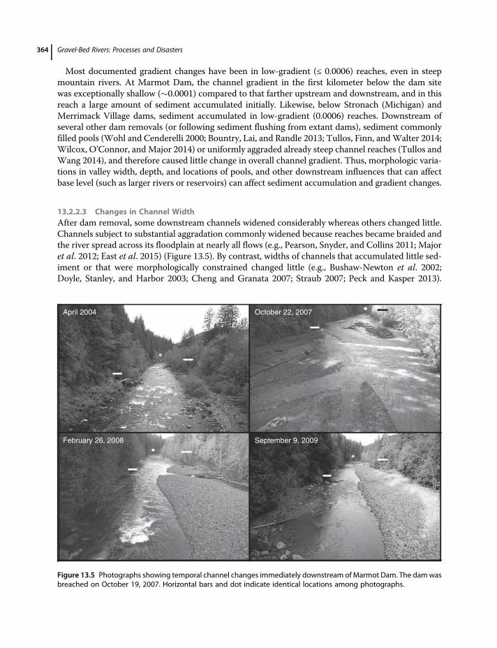
13.2.2.3 Changes in Channel WidthAfter dam removal, some downstream channels widened considerably whereas others changed little.Channels subject to substantial aggradation commonly widened because reaches became braided andthe river spread across its floodplain at nearly all flows (e.g., Pearson, Snyder, and Collins 2011; Majoret al. 2012; East et al. 2015) (Figure 13.5). By contrast, widths of channels that accumulated little sed-iment or that were morphologically constrained changed little (e.g., Bushaw-Newton et al. 2002;Doyle, Stanley, and Harbor 2003; Cheng and Granata 2007; Straub 2007; Peck and Kasper 2013).
September 9, 2009
October 22, 2007
February 26, 2008
April 2004
Figure 13.5 Photographs showing temporal channel changes immediately downstream ofMarmot Dam. The damwasbreached on October 19, 2007. Horizontal bars and dot indicate identical locations among photographs.
Gravel-Bed Rivers: Processes and Disasters364
Sometimes, valley morphology affected active channel width more than did sediment deposition(e.g., Skalak, Pizzuto, and Hart 2009; Skalak et al. 2011; Tullos and Wang 2014; Wilcox, O’Connor,and Major 2014).
13.2.2.4 Changes in Channel Bed TextureSediment releasedbydamremoval can shift grain-sizedistributionof thedownstreamchannel bed towardthat of the reservoirdeposit, but that shift canvary spatially and temporally.Damemplacementcommonlyinduces coarsening (winnowing) of the downstream bed as sediment supply is restricted. As a result, damremoval commonly induces fining of the channel bed until upstream input declines and the river reworksdeposited sediment. Though the bed may coarsen after initial sediment input is reworked, it may remainfiner than the pre-removal bed under new equilibrium conditions. Typically, most fining is restricted towithin a few kilometers of the dam site (e.g., Cheng andGranata 2007; Rumschlag and Peck 2007; Skalaket al. 2011; Major et al. 2012; Colaiacomo 2014; Harris and Evans 2014), but following some removalschanges in bed texture have extended at least a few tens of kilometers downstream (Draut and Ritchie2015; Evans and Wilcox 2014; East et al. 2015). Bed fining is not a universal response to dam removal,however. Along some gravel-bed rivers, released sediment coarsened the channel bed (Burroughset al. 2009; Kibler, Tullos, andKondolf 2011; Tullos andWang2014); in others, bed texture changed little.Muddy sand released by removals of low-head dams on rivers in the Midwestern United States hadnegligible impact on downstream channel texture (e.g., Doyle, Stanley, and Harbor 2003).Even where downstream fining in a gravel-bed river is negligible, deposition of fine sediment may be
ecologically significant. After removals of Elwha River and Milltown dams, fine sediment infiltratedand clogged interstitial pore spaces in gravel beds for months (Draut and Ritchie 2015; Evans andWilcox 2014). Although these fine deposits were at most a few centimeters thick, they likely degradedhabitat quality for benthic macroinvertebrates and fish redds (Wood and Armitage 1997; Jones et al.2012). On Elwha River, habitat degradation occurred before arrival of the main sediment pulse(East et al. 2015).
13.2.2.5 Changes in Channel Patterns and BedformsSediment release by dam removal can have other short-lived effects on channel morphology besidesaltering channel gradient, width, or bed texture. These effects include changes in channel pattern, fill-ing of channel pools, and creation and modification of channel bars. Glide morphology can replacepool–riffle morphology when hydraulic controls are buried (Kibler, Tullos, and Kondolf 2011; Eastet al. 2015). Aggradation ≥ 1m can change a channel from a single-thread to multithread pattern(Figure 13.5) (e.g., Major et al. 2012; Tullos and Wang 2014; Wilcox, O’Connor, and Major 2014),and new bar formation can increase channel sinuosity and braiding index (East et al. 2015). Multi-thread patterns commonly persist during high rates of bedload transport. After sediment-transportrates diminish and aggradation ceases, channels incise and revert to single-thread patterns. Reversionto a single-thread channel can happen swiftly, within days to months (e.g., Pearson, Snyder, andCollins 2011; Major et al. 2012; Wilcox, O’Connor, and Major 2014). Even where gross channel pat-terns were not altered, channel pools commonly filled (e.g., Wohl and Cenderelli 2000; Bountry, Lai,and Randle 2013; Peck and Kasper 2013; Harris and Evans 2014; Wilcox, O’Connor, and Major 2014)and channel relief was modified (Zunka, Tullos, and Lancaster 2015).Sediment release by dam removalmay create new channel bars ormodify existing bars. New barsmay
grow or existing bars may enlarge as released sediment moves downstream (Wohl and Cenderelli 2000;Doyle, Stanley, and Harbor 2003; Kibler, Tullos, and Kondolf 2011; Major et al. 2012; East et al. 2015;Zunka, Tullos, and Lancaster 2015). But even these geomorphic changes can be short-lived. Withinweeks of breaching Marmot Dam, bars flanking the channel within 1 km of the dam site were finer
Geomorphic Responses to Dam Removal in the United States 365
grainedandpositioned in locations independentofbars that existedprior tobreaching.Within2months,however, bar surfaces had coarsened, andwithin a year bar locations, forms, and compositionswere sim-ilar to thosebefore breaching (Major et al. 2012).After removingBrownsvilleDam, downstreambar areaand volume within 1 km of the dam site increased several fold and new riffles formed – changes thatpersisted for at least 2 years (Kibler, Tullos, and Kondolf 2011). But valley morphology and river dyna-mism may influence formation and modification of channel bars more than does sediment release bydam removal. After failure of Barlin Dam, forms and distributions of downstream bars remainedunchanged even after passage of 107 m3 of gravel and sand (Tullos and Wang 2014).
13.3 Factors Influencing Responses to Dam Removals
The varying responses to dam removal – both in the reservoir and downstream – are affected by sev-eral controlling factors. Studies so far suggest important controls include dam height, reservoir sed-iment volume and composition, removal strategy, and downstream channel and valley morphology.Hydrology and watershed setting appear to be subordinate influences on the initial geomorphicresponse downstream, but may have great influence on longer-term response. Sawaske and Freyburg(2012) noted similar influential factors in an analysis of responses to 12 small-dam removals.O’Connor, Duda, and Grant (2015) briefly summarize more recent findings.
13.3.1 Dam Height and Removal Strategy
Damheight influences geomorphic response to removal in two ways. First, it affects the amount of sed-iment and water in storage. Tall dams typically store large volumes (>500 000 m3) of sediment andmayimpound large volumes of water. By contrast, short dams are typically run-of-river structures that storesmall to moderate volumes of sediment and limited water, and they typically have passed sediment formany years. Second, dam height controls the overall base-level fall induced by dam removal.Removal strategy affects the rate at which full base-level fall is achieved, which influences the rate of
reservoir erosion and downstream sediment delivery. Full base-level fall is achieved rapidly duringsudden removal of a dam, or gradually during phased removal. Sudden breaching of tall dams, includ-ing Savage Rapids Dam (12 m),MilltownDam (12.8 m),Marmot Dam (15 m), Condit Dam (38 m), andfailure of Barlin Dam (38 m) induced rapid and extensive erosion in the respective reservoirs(Figure 13.3). Sudden breaching led to rapid but varying degrees of channel incision, channel widen-ing, knickpoint and knickzone advance, and, at Condit Dam, highly mobile landslides (Epstein 2009;Major et al. 2012; Bountry, Lai, and Randle 2013; Tullos and Wang 2014; Wilcox, O’Connor, andMajor 2014). By contrast, phased removals of 64-m-tall Glines Canyon Dam and 32-m-tall ElwhaDam, neither of which impounded a reservoir filled with sediment, resulted in comparatively slowersediment release because rates of base-level fall were modulated and because deltas had to progradethrough dwindling pools before bedload passed the dam sites (Randle et al. 2015). Although reservoirerosion wasmostly by channel incision and fluvial lateral widening, many small-scale slumps and bankcollapses (1–5m tall) also contributed to sediment delivery (Randle et al. 2015). However, neitherextensive landslides nor pronounced knickpoint migration occurred.Erosional processes similar to those observed after breaching of tall dams have been observed after
sudden and phased removals of smaller dams. In many instances, those processes have removedsediment more slowly from reservoirs behind small dams (Figure 13.3) (e.g., Doyle, Stanley, andHarbor 2003; Harris and Evans 2014). However, following removals of 4-m-tall Merrimack VillageDam (New Hampshire; Pearson, Snyder, and Collins 2011) and 3-m-tall Simkins Dam (Maryland;
Gravel-Bed Rivers: Processes and Disasters366

Collins et al. 2014), rapid incision and channel widening in sandy reservoir sediment removed morethan 40% of the stored volumes within months (Figure 13.3). By contrast, phased removals of smalldams (e.g., Brewster Creek and Stronach dams; Table 13.1) strongly modulated erosion of reservoirsediment (Straub 2007; Burroughs et al. 2009; Figure 13.3). Although similar processes erode andevacuate sediment from reservoirs impounded by both small and tall dams, these examples showthe rate and magnitude of base-level fall induced by dam-removal strategy has a strong influenceon the rate and magnitude of reservoir-sediment erosion.
13.3.2 Relations Among Reservoir Sediment Volume, Rate of Sediment Release,and Background Sediment Flux
Two dimensionless ratios, both incorporating a river’s background sediment flux, may provide pre-dictive insights on the extent and duration of geomorphic impact upon dam removal. One ratio, V∗,provides a relation between the volume of stored reservoir sediment and volume of average annualsediment load at the dam site (e.g., Burroughs et al. 2009; Major et al. 2012; Tullos and Wang2014;Wilcox, O’Connor, andMajor 2014). The other ratio, E∗, provides a relation between the volumeof sediment eroded in the first year after removal (or the first year after sediment began passing a damsite if removal was phased) and background sediment flux (Grant and Lewis 2015).The ratio V∗ provides a measure of the potential magnitude of perturbation to the downstream
channel. It may also provide some insight on potential duration of the downstream response. Forexample, if V∗ is relatively small (≤20), the overall downstream impact may be modest (though locallyimpressive) because the downstream channel receives a sediment input not substantially greater thanthat to which it is equilibrated. Also, the primary downstream response to sediment release may be ofrelatively short duration (months to years) because the river will likely redistribute released sedimentswiftly and reequilibrate. By contrast, if V∗ is large (several tens to hundreds), the river system mayreceive a sediment input much greater than that to which it is equilibrated and may take many years,and possibly decades, to effectively redistribute released sediment and reequilibrate.Two removals highlight the potential utility of V∗ as a gross predictor of order-of-magnitude dura-
tion of principal downstream geomorphic response. Marmot Dam stored about 750 000 m3 of sedi-ment. At its location, the average annual sediment flux of Sandy River is about 100 000 to 200 000 m3.Hence, removal of Marmot Dam released an effectively small volume of sediment to Sandy River –probably less than a decade’s worth (V∗ < 10; Figure 13.6). Despite swift erosion of a large amount ofstored sediment (>40% within 8 weeks; Figure 13.3; Major et al. 2012), suspended-sediment loadsreturned to background level within months of removal and pre-removal channel form and texturejust downstream of the dam site – the reach most affected by released sediment – began to reestablish(Figure 13.5; Major et al. 2012). Within a year of removal, channel form and texture in that reach hadlargely reestablished though bed elevation and relief remained significantly changed from pre-removalconditions (Major et al. 2012; Zunka, Tullos, and Lancaster 2015). Within about 5 years after removal,morphology and longitudinal profile of the channel extending 2 km downstream of the dam site hadmostly stabilized (J.J. Major unpublished data; Zunka, Tullos, and Lancaster 2015). By contrast, twodams on Elwha River storedmuch greater relative volumes of sediment (Figure 13.6). The Glines Can-yon ( 16 million m3) and Elwha ( 5 million m3) dams impounded a combined 21 million m3 ofsediment (Randle et al. 2015). The average annual sediment load of Elwha River entering Lake Millsbehind Glines Canyon Dam is about 200 000–300 000 m3 (Curran et al. 2009; Magirl et al. 2015).Thus, Glines Canyon Dam impounded about 50–80 years of average annual sediment load (V∗
50–80), and Elwha Dam impounded about 15–25 years of (unregulated) average sedimentload (V∗ 15–25). Over the first 2 years of phased removal of these dams, about 7 million m3 of
Geomorphic Responses to Dam Removal in the United States 367

sediment was released (Randle et al. 2015), an amount equivalent to about 20–40 years of averageannual load. Most of that released sediment passed through the 22-km-long channel corridor belowGlines Canyon Dam and was delivered to a coastal zone (Warrick et al. 2015). However, the sedimentdeposited along the channel induced changes in elevation, pattern, and texture (East et al. 2015) towhich the river is still responding some 4 years (at the time of this writing) after removals began. Sed-iment release from the former Lake Mills reservoir will continue over the coming years, especiallyduring high-discharge events. The duration of major downstream response remains to be determined.These two examples show the relative magnitude of stored sediment to background sediment flux caninfluence the duration of downstream geomorphic response, especially if the river is able to access anderode large amounts of stored reservoir sediment.Though the relative magnitude of the amount of sediment in storage broadly influences the nature
and duration of downstream geomorphic response, the rate at which sediment is released is clearly aninfluential factor. Grant and Lewis (2015) approached the influence of rate of sediment release usingthe dimensionless ratio E∗. They examined the utility of using this ratio for predicting patterns ofdownstream sediment transport. For a limited number of removals in the US Pacific Northwest, theyfound that E∗ did a better job of predicting the transport distance of coarse sediment (sand and gravel)than fine sediment (mud and fine sand). In general, fine sediment was transported downstream assuspended load and its transport distance correlated poorly with E∗. By contrast, coarse sedimentis transported as bedload and its transport distance – when not interrupted by downstream sedimentsinks such as other reservoirs or confluences with larger rivers – appears to correlate positively withE∗. That is, the greater the initial sediment delivery relative to background sediment flux, the fartherdownstream coarse sediment (mostly sand) is transported. If this simple empirical relation holds forother regions (especially for small dams on low-gradient rivers), it may prove a useful tool for quicklyestimating possible spatial consequences of dam removals.
Estimated reservoir sediment volume, in cubic meters
0.1
1
10
100
1000E
* and V
*
Marmot
Brewster Savage Rapids
Glines CnCondit
IVEX
Merrimack
Rockdale
La Valle
Brownsville
103 104 105 106 107 108
ElwhaSimkinsStronach
Lost ManBarlin
Marmot Predominanty sand and gravel
IVEX >30% mud (silt and clay)
Glines Phased removal
E*
V*
Figure 13.6 Volumes of stored sediment (V∗) (triangles) and volumes of sediment eroded during first year followingdam removal (E∗) (black dots) relative to background sediment fluxes as a function of stored sediment volumes forrecent dam removals. Vertical lines added for clarity to identify data points for given dams. Data for Glines Canyon Damare for the second year following initiation of breaching because that is when most sediment, especially bedloadsediment, began passing the dam site (see Figure 13.3 for additional information).
Gravel-Bed Rivers: Processes and Disasters368

13.3.3 Reservoir-Sediment Grain Size
Sediment grain size (caliber) influences reservoir erosion processes and downstream effects ofreleased sediment. In conjunction with the style of dam removal and degree to which sediment fillsa reservoir, sediment grain size influences the nature and pace of reservoir erosion. It also affects con-sequent transport and storage of sediment downstream, and the distribution and residence time of thetransported sediment.Upon dam removal, reservoirs impounding coarse sediment commonly erode more completely and
more rapidly than do those impounding fine sediment (Figure 13.3). The principal exception to this isCondit Dam, where highly mobile landslides swiftly evacuated a great amount of fine sediment. Dif-ferences in sediment characteristics, such as cohesion and consolidation of fine sediment, sedimentstratification, and degree of saturation affect these granulometric differences in erosion rates. But theapparent differences may be biased by the limited number of removals and removal strategiesexamined to date, especially among large-dam removals. Few large dams impounding mostly finesediment have been removed. And among those dams which we examined that impounded finesediment, nearly half were removed incrementally, which modulated the rate of base-level fall(Figure 13.3). Nevertheless, differences among grain-size distributions of reservoir sediment appearto influence erosion rates upon dam removal.Grain size of released sediment affects downstream impacts and responses regardless of removal
strategy. Released fine sediment commonly has less downstream impact than coarse sediment. Apartfrom small-volume fine-sediment deposition as interstitial fill, most fine sediment is transporteddownstream as suspended load that temporarily increases turbidity and suspended-solids concentra-tion (Doyle, Stanley, and Harbor 2003; Granata, Cheng, and Nechvatal 2008; Major et al. 2012; Magirlet al. 2015). Following some removals, fine sediment accumulated thinly on floodplains or along chan-nel margins when flows were either deep enough to spill overbank or had relatively little transportcapacity relative to fine-sediment supply (e.g., Evans et al. 2000; Draut and Ritchie 2015). In instanceswhere downstream reservoirs interrupted sediment transport, substantial amounts of fine sedimentaccumulated (Evans et al. 2000).Even large-volume releases containing abundant fine sediment have had relatively little downstream
impact. Although abundant fine sediment at Condit Dam promoted conditions for hyperconcentratedflow upon breaching, that flow selectively draped the downstream channel corridor with sand andlargely passedmud through the system (Wilcox, O’Connor, andMajor 2014).Most of the fine sedimentreleased by the concurrent removals of the Elwha River dams passed through the 22-km-long down-stream corridor (Warrick et al. 2015). Fine sediment retained along the channel corridor initially infil-trated the pre-removal gravel bed, formed small bars along the channel margin, or draped floodplainchannels (Draut and Ritchie 2015; East et al. 2015), but its deposition prompted little geomorphicresponse.Coarse sediment, by contrast, can prompt substantial downstream geomorphic response. Coarse
sediment release can increase bedload transport many fold, aggrade channel beds, coarsen or finedownstream bed texture, and modify channel pattern and morphology. These effects commonlyare pronounced when large amounts of coarse sediment are released rapidly, especially when theamount released overwhelms transport capacity.Coarse-sediment released by removals of small dams, mostly sand, has had modest impact relative
to that released by removals of tall dams. Although sediment released by some small-dam removalscaused substantial (1–3m) channel aggradation, most releases induced only minor changes in bedelevation within a few kilometers downstream of a dam site. Commonly, those releases had littleto modest effect on channel pattern owing mainly to pool filling, modification of local channel relief,
Geomorphic Responses to Dam Removal in the United States 369
or minor modifications to channel bars and riffles. They have also had varying effects on channel-bedtexture. Typically, the effects of coarse sediment released by small-dam removals have been short-lived (months to perhaps a few years). By contrast, downstream impacts of coarse sediment releasedby removals of tall dams have been more profound regardless of removal strategy. Voluminousreleases that have delivered sediment pulses that rival substantial natural events in scale have aggradedchannel beds by as much as 10 m (Tullos and Wang 2014) and substantially modified channel relief,channel patterns, and bed texture (Major et al. 2012; Colaiacomo 2014; Tullos and Wang 2014;Wilcox, O’Connor, and Major 2014; East et al. 2015; Zunka, Tullos, and Lancaster 2015).The effects of releasing large volumes of coarse sediment appear to last longer if the sediment con-
tains a substantial proportion of gravel. After breaching Marmot Dam, gravel that accumulated in the2-km-long reach downstream of the dam site (Figure 13.4) has remained largely in storage for nearly adecade after removal (J.J. Major unpublished data). Released sand that moved much farther down-stream had limited and apparently short-lived effects (Major et al. 2012). Sand and minor gravelreleased by removal of Condit Dam swiftly aggraded the channel bed several kilometers downstreamof the dam site by as much as 1 m after passage of the initial hyperconcentrated flow, but within days ofattaining maximum aggradation that fill was incised nearly to the pre-removal level of channel riffles(Wilcox, O’Connor, and Major 2014). Such rapid incision shortly after maximum aggradation wasdue, in part, to a lack of gravel capable of armoring the bed surface and to rapid reduction of sedimentsupply.
13.3.4 Breach and Post-Breach Hydrology
There is little correlation between the proportion of sediment evacuated from the reservoir and mag-nitude of river flow during and after dam breaching. Several dams have been breached during low tomoderate flows – flows much smaller than the 2-year-return-interval flow. Yet, during breaching andin the ensuing days to months these moderate flows in many cases rapidly evacuated large fractions ofimpounded sediment (Figure 13.7; Pearson, Snyder, and Collins 2011; Major et al. 2012; Bountry, Lai,and Randle 2013; Collins et al. 2014; Tullos and Wang 2014; Wilcox, O’Connor, and Major 2014;Magirl et al. 2015; Zunka, Tullos, and Lancaster 2015). Even during phased removals, such as thoseon Elwha River, moderate flows eroded large fractions of reservoir sediment if the rate of base-level fallinduced sufficient change in slope to mobilize a broad range of sediment sizes (e.g., Magirl et al. 2015;Randle et al. 2015). By contrast, large flows have been most important for accessing and evacuatingharder-to-reach remnant sediment that becomes isolated along reservoir margins or stranded on ter-races, and in redistributing sediment deposited downstream (Pearson, Snyder, and Collins 2011;Major et al. 2012; Harris and Evans 2014; Tullos and Wang 2014). In gravel-rich rivers, large flowsbecome especially important for evacuating remnant reservoir sediment and redistributing it asthe channel within the reservoir and downstream armors.Breaches that released substantial water volumes generated brief peak flows equivalent to low-
frequency, high-magnitude floods. But in two well-documented examples, those water releases didnot erode large amounts of sediment from reservoirs. Evans et al. (2000) documented a release ofabout 38 000 m3 of water within minutes during failure of IVEX Dam (Ohio), producing a 466m3/s peak flow (>100-year flood?), yet only about 25 000 m3 (10%) of impounded sediment had erodedafter 2 months. Breaching of Condit Dam released 1.6millionm3 of water in a little more than an hour,generating a 420 m3/s peak flow (>100-year flood). However, substantial evacuation of reservoir sed-iment did not occur until landslides became prevalent after the water had drained (Wilcox, O’Connor,and Major 2014).
Gravel-Bed Rivers: Processes and Disasters370
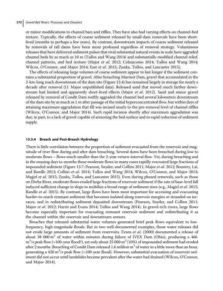
Lack of correlation between rate of sediment erosion and flow magnitude reflects the relativeimportance of process-based erosion versus event-based erosion, a conceptual model proposed byPizzuto (2002) and extended by Pearson, Snyder, and Collins (2011). Process-based erosion, whichis largely independent of flow magnitude, occurs when there is a great change in reservoir equilibriumupon dam removal (sudden channel initiation, rapid migration of headcuts and knickpoints, etc.).Event-based erosion follows when high flows are needed to access and exceed transport thresholdsfor remnant sediment (Pearson, Snyder, and Collins 2011). Removals to date highlight the generalvalidity of this conceptual model.Under disequilibrium conditions caused by reservoir-sediment release, modest flows can also trans-
port abundant sediment downstream. For example, during the first year after removal of MarmotDam, peak flows were no larger than 60% of the discharge of a 2-year flood and mean annual flowwas only 18% greater than long-term mean flow. Under these conditions, unit-width bedload fluxeswithin 10 km downstream of the dam site approached some of the highest values measured for gravel-bed rivers (3–4 kg/s/m; Major et al. 2012). During the phased removals of the Elwha River dams,2 years of muted flows having peak discharges about 70% of the discharge of a 2-year flood transported90% of the released sediment ( 9 million tonnes) to the river mouth (Magirl et al. 2015; Warrick et al.2015). Release of a small volume of gravel ( 15 000 m3) by removal of Brownsville Dam and subse-quent modest flows during the year after removal led to substrate coarsening, growth of channel bars,and an increase in habitat heterogeneity within a few hundred meters of the dam site, but little changefarther downstream (Kibler, Tullos, and Kondolf 2011).To date, there has yet to be an intentional dam removal contemporaneous with, or followed closely
by, a large, naturally occurring flood. Thus, there is uncertainty regarding exactly how a river systemmight respond to such a scenario. Major et al. (2012) speculated that the sequencing of flow magni-tudes atMarmot Dam influenced reservoir-sediment erosion at the time scale of individual events, buthad little effect on total erosion 2 years after removal. They further speculated that had large-magnitude flows occurred at or shortly after breaching, a similar proportion of reservoir erosion wouldhave been achieved after 2 years, but likely by a different erosion trajectory. Comparison of erosion
0.6 0.8 1 1.2 1.4 1.6
Mean flow first year/mean annual flow
0
20
40
60
80
100
Perc
ent sedim
ent ero
ded in first year
Merrimack
Glines Cn
Elwha
Simkins
Savage Rapids
Condit
Marmot
Brownsville
Secor
Marmot Predominantly sand and gravel
Condit >30% mud (silt and clay)
Glines Phased removal
Figure 13.7 Fraction of reservoir sediment volume eroded as function of relative mean-flow magnitude during firstyear following dam removal. Data for Glines Canyon Dam are for the second year following initiation of breachingbecause that is when most sediment, especially bedload sediment, began passing the dam site (see Figure 13.3 foradditional information). Data for Secor Dam represent fraction of sediment eroded within 6 months of breaching.
Geomorphic Responses to Dam Removal in the United States 371
trajectories at Merrimack Village Dam (MVD) and Simkins Dam (Figure 13.3) support this specula-tion. Both dams were of similar height and stored similar sediment volumes and compositions(Table 13.1), had similar upstream contributing areas, similar hydroclimate regimes, and wereremoved suddenly. No large flows (≥10-year event) occurred within 2 years of removal of MVD(Pearson, Snyder, and Collins 2011) whereas a 10-year event occurred within months of removalof Simkins Dam (Collins et al. 2014). Similar proportions of reservoir sediment eroded after 2 yearsfrom each dam site, but by slightly different trajectories.
13.3.5 Downstream Valley Morphology
Downstream valley morphology can affect overall river system response to sediment release from damremoval. Valley morphology can act as a filter that affects sediment storage and transport and influ-ences the fate of differential sediment distribution. After removal of Marmot Dam, released gravelaccumulated largely along a narrow, low-gradient reach immediately downstream of the dam site.By contrast, nearly all released sand passed much farther downstream (Figure 13.4; Major et al.2012). Following failure of Barlin Dam, resistant valley walls and valley-forced meandering affectedthe locations, sizes, and geometries of channel bars, channel width, and lateral migration (TullosandWang 2014). Following breaching of Condit Dam, a narrow, bedrock-confined reach immediatelybelow the dam passed much of the released sediment several kilometers downstream to a broader,lower-gradient reach where it accumulated thickly (Colaiacomo 2014; Wilcox, O’Connor, and Major2014). In the weeks following breaching, bed elevation within the bedrock reach adjusted toward thepre-removal level of riffles but pools remained filled (Colaiacomo 2014). After removal of SavageRapids Dam, the overall bed elevation in the 3-km reach downstream of the dam site changed little,but spatially progressive changes in residual pool depths reflected downstream advance of sedimentfor at least 2 years after removal (Tullos, Finn, and Walter 2014).Existing morphology can also affect bed relief, and thus channel complexity, that develops from
deposition of released sediment. Sediment released to low-relief channels can increase local relief bybuilding channel bars, but it can decrease relief in high-relief channels by filling pools, by replacingpool–rifflemorphologywith glides, and by forming short-livedmid-channel bars (Wohl andCenderelli2000; East et al. 2015; Zunka, Tullos, and Lancaster 2015). The style, timing, and duration of down-stream sediment transport can also be affected by channel morphology. Channel bars and pools canserve as sites of temporary, or even long-lived, sediment accumulation (Wohl and Cenderelli 2000;Doyle, Stanley, and Harbor 2003; Kibler, Tullos, and Kondolf 2011; Harris and Evans, 2014), andfloodplains can trap sediment even during low flows if channel aggradation is sufficient (e.g., Evanset al. 2000; Burroughs et al. 2009; East et al. 2015). These sediment-storage reservoirs can limit impactfarther downstream by disrupting or buffering sediment transport and can extend the duration ofimpact of released sediment.
13.3.6 Watershed Geologic Setting and Geographic Context
Watershed geologic setting and geographic context can strongly affect response to dam removal.Where a dam sits in a watershed broadly influences the impact its removal has on the downstreamchannel. Its position influences the caliber and quantity of reservoir sediment, its hydrological regime,and the potential for the downstream channel to store or transmit sediment – all of which affect thespatial extent of downstream impact. Geographic context also includes the presence of dams upstreamor downstream of the removed dam, which influences sediment supply and downstream transport andstorage.
Gravel-Bed Rivers: Processes and Disasters372
Though geologic and geographic context can affect short-term response to dam removal, theylikely have greater influence on long-term response. Skalak, Pizzuto, and Hart (2009) argue thatmany rivers in the US Mid-Atlantic region are bedrock channels mantled with a thin gravel cover.This morphology is related to low rates of sediment supply, transport, and storage typical of theregion. Thus, stability of exposed bedrock and boulders exerts a very strong control on overallchannel morphology, which influenced long-term erosion, transport, and storage of sediment.Removals of small dams in this region typically release short-lived pulses of sediment commonlyfiner grained than the composition of the downstream bed. Although these pulses may brieflyalter channel morphology and bed composition, sediment supplies eventually approach water-shed delivery rates. Thus, long-term response to sediment delivery is more likely to be controlledby the configuration and stability of exposed bedrock and immobile boulders than by modestsediment release from dam removal. As a result, gross geomorphic characteristics of channelsmay remain relatively unaffected by small-dam removals (Skalak, Pizzuto, and Hart 2009; Skalaket al. 2011).Responses to removals of tall dams in the US Pacific Northwest and to a dam failure in Taiwan also
exemplify influences of geology and geography. Sandy River, Oregon, drains Mount Hood, an activevolcano in the Cascade Range. Large volumes of volcanic sediment are stored along the length ofSandy River, and provide locally dynamic sediment sources. Upon removal of Marmot Dam, releasedsand passed far downstream. However, river dynamism and local sediment sources masked thedistribution of that sand. The configuration of confined bedrock and wider alluvial reaches alongWhite Salmon River affected the transport and storage of sediment released by breaching of ConditDam (Colaiacomo 2014; Wilcox, O’Connor, and Major 2014). Similarly, valley-forced morphology aswell as basin-wide variations in caliber and quantity of sediment transport owing to lithological influ-ences affected rates and types of channel adjustments to the sediment pulse delivered by failure ofBarlin Dam (Tullos and Wang 2014).
13.4 Time Scales of Channel Responses to Dam Removals
Channel perturbation involves a reaction time over which channel conditions diverge from a state ofstability, and a relaxation time during which perturbed channel conditions converge toward a state ofstability (e.g., Graf 1977; Pierson and Major 2014). In the context of dam removal, reaction times maybe short or prolonged – hours to days following sudden removal, or months to years during phasedremoval. Relaxation times can be highly variable, and systems may converge toward an equilibriumstate that differs from the pre-dam state. Following dam removal, reaction and relaxation timescalestypically overlap. Although large amounts of reservoir sediment can be evacuated swiftly followinginitial breaching of a dam, erosion commonly continues to remove and deliver sediment downstreamfor protracted periods –months to years, perhaps decades. Thus, the channel downstream can simul-taneously be responding to and relaxing from an initial perturbation while being perturbed further byadditional sediment delivery. Nevertheless, relaxation times toward a state of relative stability follow-ing dam removals have been shorter than commonly anticipated – years, not decades. Pizzuto (2002)hypothesized that evolution of an equilibrium channel through reservoir sediment might take at least adecade depending on mass and grain size of the sediment. Yet in many cases more than a third, andsometimes two-thirds, of stored sediment has been evacuated within weeks to months of dam removal(e.g., Sawaske and Freyburg 2012; Figure 13.3), and relatively stable channels within reservoirs haveestablished swiftly. Even during phased removals of Elwha River dams, approximately a third of the
Geomorphic Responses to Dam Removal in the United States 373
total sediment stored behind two dams was evacuated in the first 2 years of the removal project(Randle et al. 2015; Warrick et al. 2015), and about half evacuated after 3 years (C.S. Magirl unpub-lished data). But owing to continued erosion, reservoir-reach channels on Elwha River have yet to sta-bilize after 4 years.Major downstream channel adjustments following dam removal commonly achieved apparent sta-
bility within months to years. In several instances, bed textures, channel patterns and gradients, barmorphologies, and sediment transport rates approached pre-removal or pre-dam conditions within ayear or two, although pools commonly remained filled (Bushaw-Newton et al. 2002; Doyle, Stanley,and Harbor 2003; Pearson, Snyder, and Collins 2011; Major et al. 2012; Peck and Kasper 2013;Coloaiacomo 2014; Tullos, Finn, andWalter 2014; Tullos andWang 2014; Kim, Toda, and Tsujimoto2015; Zunka, Tullos, and Lancaster 2015). The principal exception is Elwha River owing to continueddelivery of large amounts of sediment. But now that the dams have been removed completely and atleast half the sediment has been evacuated, and mostly passed to the coastal zone, stability maybe achieved within a few years. Although major channel adjustments commonly occur swiftly,minor adjustments, such as decimeter-scale fluctuations of bed elevation, migration of smallsecondary bars, and adjustments of particle sorting, may persist for several years (Skalak et al.2011; Greene, Krause, and Knox 2013; Peck and Kasper 2013).Although rivers appear to recover rapidly after perturbations induced by dam removals, long-term
assessments of responses to removals are rare. As of 2015, the longest lasting responses to damremovals have resulted from accumulation of gravel, local aggradation and filling of deep pools withsand, or substantial deposition in downstream reservoirs that interrupted sediment transport(e.g., Evans et al. 2000; Evans 2007; Skalak et al. 2011; Major et al. 2012; Peck and Kasper 2013: Zunka,Tullos, and Lancaster 2015). Seven years after removal of Marmot Dam, the profile of Sandy River inthe first kilometer below the dam site still reflects substantive gravel accumulation, and minor fluc-tuations of bed elevation and local redistribution of sediment among channel bars persist (J.J. Majorunpublished data). Five years after removal of Munroe Falls Dam (Ohio) sand deposited on the chan-nel bed 2–3 km downstream of the dam site continued to influence activation of meander-bend chutesat all but the lowest flow, particle sorting persisted, and sandy deltaic deposits remained at the head ofa reservoir 5 km downstream (Peck and Kasper 2013). Four years after removal of the low-head Man-atawny Dam (Pennsylvania), which impounded sand and gravel, modest channel adjustments contin-ued both upstream and downstream of the dam site (Skalak et al. 2011). And 12 years after failure ofIVEX Dam, sand released more slowly from a delta at the upper end of the reservoir-reach had deliv-ered twice the volume to a downstream reservoir as did the initial flush of fine sediment released byfailure (Evans 2007). The overall findings from recent dam removal studies of rapid relaxation of sed-iment perturbations present a contrast with the hypothesis of much longer-term adjustments tobreaching of low-head, colonial-age mill dams in the US Mid-Atlantic region (Merritts et al.2013). That hypothesis proposes that erosion of sediment impounded by these structures has persistedfor decades to centuries after breaching, and largely accounts for most of the present-day, fine-grainedload delivered downstream.Construction or exposure of grade-control features after dam removal can affect long-term sedi-
ment accumulation and erosion in reservoirs and consequent downstream response. An analysis ofgeomorphic response 10 years after removal of La Valle Dam (Wisconsin) showed that a man-maderiffle constructed at the dam site altered flow hydraulics and sediment transport (Greene, Krause, andKnox 2013). That riffle induced renewed sedimentation in the reservoir reach, which subsequentfloods eroded and redistributed downstream. Similar hydraulic and sediment-transport conditionsestablished behind Homestead Dam (New Hampshire) after resistant boulders were exposed justupstream of the dam site (Gartner, Magilligan, and Renshaw 2015).
Gravel-Bed Rivers: Processes and Disasters374
Local and system-wide relaxation times also depend upon the manner in which a sediment pulsemoves downstream. A pulse of sediment introduced to a channel may disperse in place and diffusedownstream, translate downstream as a discrete sediment wave, or exhibit hybrid behavior (Lisleet al. 2001; Lisle 2008; Sklar et al. 2009). The manner of transport affects the magnitude and dura-tion of downstream impact – a sediment pulse that disperses downstream may induce lower-magnitude changes, but have longer-lasting impact than does a pulse translating as a discretewave. Theoretical, experimental, and field studies indicate sediment pulses on gravel-bed riverspropagate by translation rather than dispersion when pulse volume is small relative to channeldimensions, grain size is finer than the downstream river bed, and Froude number is low(<0.4) (Lisle et al. 2001; Lisle 2008; Sklar et al. 2009; Madej et al. 2009; Pryor et al. 2011). By con-trast, sediment dispersion is favored when sediment volume is large relative to channel dimen-sions, grain-size distribution is broad and contains particles coarser than the channel bed, andFroude number is high (>0.4). There are few studies of dam removals that specifically addressthe manner of downstream sediment propagation (e.g., Evans, Huxley, and Vincent 2007; Thomaset al. 2014), but some provide provocative, and sometimes contradictory, observations. Within aweek of breaching Condit Dam, Wilcox, O’Connor, and Major (2014) documented a distinct riseand fall of the channel bed a few kilometers downstream of the dam site as large amounts of sandand some gravel passed. This rapid change of channel-bed elevation, even though sediment vol-ume was large relative to channel dimensions and Froude number was high ( 1), suggests passageof a translating sediment wave. Similar cycles of downstream aggradation and degradation wereobserved following release of gravelly sediment by failure of Barlin Dam (Tullos and Wang2014). By contrast, East et al. (2015) suggest that progressive but sustained low-magnitude changesin bed elevation on Elwha River during phased dam removals reflect sediment-pulse dispersion – aresult that owes largely to the great volume of sediment released. Subsequent to removal of Mar-mot Dam, proximally deposited gravel was redistributed, but by 7 years after removal there was noevidence that it had translated downstream as a discrete sediment wave (Major et al. 2012; J.J Majorunpublished data).Regardless of how sedimentmoves downstream, when its supply exceeds a river’s transport capacity,
deposition occurs and bed texture and morphology are modified. Experiments show introduced sed-iment pulses obliterate much of the downstream channel morphology at the reach scale and changeboth mean and spatial patterns of bed elevation and texture (Lisle et al. 2001; Cui et al. 2003; Sklaret al. 2009; Podolak and Wilcock 2013). Experiments also show bed topography and textural patternsadjust over different time scales (Podolak and Wilcock 2013). But even after channels have achievedlargely stable topographic and textural patterns similar to those extant before passage of a sedimentpulse, spatially variable secondary textural and topographic adjustments may persist, includingchanges in particle sorting, minor bed-elevation fluctuations, and migration of secondary bars muchsmaller in scale than major channel bars (Podolak and Wilcock 2013). Although these persistent sec-ondary adjustments may induce only modest geomorphic changes to the downstream channel, theymay have important ecological ramifications.
13.5 Common Findings from Analyses of Responses to Dam Removals
Despite the variety of dam heights, reservoir sediment volumes and compositions, and removalstrategies, a number of common findings have emerged with regard to geomorphic responsesfollowing dam removals.
Geomorphic Responses to Dam Removal in the United States 375
1) Rivers are resilient. After dam removals, rivers have largely achieved apparent stability – at leastwithin their range of natural variability – within a few years rather than decades. Despite concernsabout rapidly releasing possibly large volumes of sediment to river systems, most removals to datehave shown adverse geomorphic impacts (such as complete bed-texture transformation, enhancedflood risk, or damage to fish habitat) are short-lived and have been neither as damaging nor as long-lasting as feared. Although locally minor steps in reservoir profiles sometimes developed owing toexposure of resistant bedrock, boulders, or buried structures, concerns about development ofstepped profiles capable of impeding upstream fish passage have been unfounded thus far.
2) Modest streamflows can effectively evacuate large percentages of reservoir sediment and move itdownstream. Rapid evacuation and transport is associated with two key factors: (i) sediment com-position; and (ii) establishment of extraordinary river capacity and competence owing to abruptchange in base level during dam breaching. In general, reservoir sediment composed dominantlyof sand and gravel erodes more swiftly and more completely than does reservoir sediment domi-nated by mud. The nature and pace of erosion can be strongly influenced, however, by exposure ofnatural and man-made features that can act as grade-controls and impose new boundaryconditions.
3) Sediment volume and caliber exert a dominant control on downstream response to dam removal.Large amounts of released gravel have had more substantial and longer-lasting downstream effectsthan has released sand and mud. But even the most substantial channel changes caused by accu-mulation of coarse sediment (such as large changes in bed elevation, changes in bed texture, andloss of pre-removal channel pattern) have not had long-lasting adverse geomorphic effects.
4) Location of a dam within a watershed, existing valley morphology, and geologic and geographicsettings can strongly influence channel response to dam removal. Locations and forms of channelbars may be governed largely by existing valley morphology. Rivers attain equilibriummore quicklywithin confined bedrock reaches than within wider, lower-gradient alluvial reaches. Regionallithology and bedrock exposure may exert a greater influence on channel morphology than eitherdam emplacement or sediment release by dam removal.
5) Predicting time to recovery from sediment release following dam removal remains challenging.Although a river will converge toward a state of equilibrium with the supplied sediment load, itmay not return to its pre-dam state. Assessment of metrics such as V∗ (ratio of impounded sed-iment volume to background sediment flux) or E∗ (ratio of sediment volume eroded within 1 yearof removal to background sediment flux) can provide qualitative insights regarding an order-of-magnitude time it may take for a river to converge to a state of stability. In general, riversconverged toward stability conditions within a few years when both V∗ and E∗ had values of ≤20.
These findings have been extracted from a limited number of field studies across geographicallyrestricted regions of the United States and a single dam failure abroad. Hence, we have no informationon geomorphic responses to dam removals from a vast region of the United States having great top-ographic, climatic, and ecological diversity. Detailed studies of responses to removals in underrepre-sented regions would bolster our ability to test the general applicability of these findings. Furthermore,there has yet to be clear integration of physical and biological responses to dam removals. Tighterintegration of the nature and pace of geomorphic and ecological responses – and their interactions –is needed to develop more thorough assessment of the impacts of sediment release by dam removal.Consistent and thorough documentation of physical and ecological responses to dam removals is
needed to improve our understanding of environmental benefits and detriments of dam removal. Werecognize that all studies are subject to logistical and financial constraints. Nevertheless, we encouragethe community to document as thoroughly as possible the following conditions: (i) pre-removal, and if
Gravel-Bed Rivers: Processes and Disasters376
possible pre-emplacement, morphological and ecological conditions of a river system; (ii) reservoir-sediment volume, grain size, and spatial distribution of grain size; (iii) regional background sedimentflux; (iv) rates and processes of reservoir-sediment erosion; (v) rates and magnitudes of downstreamsediment transport; (vi) styles, rates, and magnitudes of post-removal channel changes downstream;and (vii) long-term geomorphic adjustments to sediment release. Such measurements will improveboth our understanding of the factors that influence responses to removals and quantification of sed-iment budgets. Accurate sediment budgets would not only improve our understanding of the fate ofreleased sediment, but could also improve our ability to evaluate potential physical and ecologicalimpacts below dam sites. They would also provide critical data for evaluating numerical models thatpredict physical responses to dam removals.
Acknowledgments
We are grateful to many colleagues who helped us collect data following dam removals we investi-gated, and to colleagues who generously shared data with us. Ryan Bellmore and Jeff Duda compiledan extensive database of dam-removal publications, which we leveraged. We thank Jeff for his assis-tance creating Figure 13.1. The US Geological Survey Powell Center for Analysis and Synthesis pro-vided us the opportunity and facilities to gather to discuss what has been learned from dam removals.We thank Jim Pizzuto, Noah Snyder, and Katie Skalak for their reviews.
References
American Rivers 2014. List of Dams Removed 1998–2014. Available from www.americanrivers.org(last accessed April 17, 2015).
Babbitt, B 2002. What goes up, may come down. BioScience 52, 656–658.Bednarek, AT 2001. Undamming rivers: a review of the ecological impacts of dam removal. Environmental
Management 27, 803–814.Bellmore, J, Vittum, K, Duda, J, and Greene, S 2015. USGS Dam Removal Science Database. DOI:10.5066/
F7K935KT.Bellmore, JR, Duda, JJ, Craig, LS et al. 2016. Status and trends of dam removal research in the United States.
WIREs Water. DOI:10.1002/wat2.1164, 13 p.Bountry, JA, Lai, YG, and Randle, TJ 2013. Sediment impacts from the Savage Rapids Dam removal, Rogue
River, Oregon. In The Challenges of Dam Removal and River Restoration (eds JV De Graff and JE Evans).Geological Society of America Reviews in Engineering Geology 21, 93–104.
Burroughs, BA, Hayes, DB, Klomp, KD et al. 2009. Effects of Stronach Dam removal on fluvialgeomorphology in the Pine River, Michigan, United States. Geomorphology 119, 96–107.
Bushaw-Newton, KL, Hart, DD, Pizzuto, JE et al. 2002. An integrative approach towards understandingecological responses to dam removal: the Manatawny Creek study. Journal of the American WaterResources Association 38, 1581–1599.
Cantelli, A, Wong, M, Parker, G, and Paola, C 2007. Numerical model linking bed and bank evolution ofincisional channel created by dam removal. Water Resources Research 43, W07436. DOI:10.1029/2006WR005621.
Cheng, F and Granata, T 2007. Sediment transport and channel adjustments associated with dam removal:field observations. Water Resources Research 43, W03444. DOI:10.1029/2005WR004271.
Geomorphic Responses to Dam Removal in the United States 377

Colaiacomo, EJ 2014. Downstream spatial and temporal response to dam removal, White Salmon River,WA. MS thesis, University of Montana.
Collins, MJ, Boardman, G, Banks, W et al. 2014. Dam breach release of non-cohesive sediments: channelresponse and recovery rates. Abstract EP31E–07 presented at 2014 Fall Meeting, American GeophysicalUnion, San Francisco, CA, December 15–19.
Csiki, S and Rhoads, BL 2010. Hydraulic and geomorphological effects of run-of-river dams. Progress inPhysical Geography 34, 755–780.
Cui, Y and Wilcox, A, 2008. Development and application of numerical models of sediment transportassociated with dam removal. In Sedimentation Engineering: Processes, Measurements, Modeling, andPractice (ed. MH Garcia). ASCE Manuals and Reports on Engineering Practice 110, 995–1020.
Cui, Y, Parker, G, Lisle, TE et al. 2003. Sediment pulses inmountain rivers: 1. Experiments.Water ResourcesResearch 39. DOI:10.1029/2002WR001803.
Curran, CA, Konrad, CP, Higgins, JL, and Bryant, MK 2009. Estimates of sediment load prior to damremoval in the Elwha River, Clallam County, Washington. US Geological Survey Scientific InvestigationsReport 2009–5221, 18 pp.
Downs, PW, Cui, Y, Wooster, JK et al. 2009. Managing reservoir sediment release in dam removal projects:An approach informed by physical and numerical modelling of non-cohesive sediment. InternationalJournal of River Basin Management 7, 433–452.
Doyle, MW, Stanley, EH, and Harbor, JM 2002. Geomorphic analogies for assessing probable channelresponse to dam removal. Journal of the American Water Resources Association 38, 1567–1579.
Doyle, MW, Stanley, EH, and Harbor, JM 2003. Channel adjustments following two dam removals inWisconsin. Water Resources Research 39, 1011. DOI:10.1029/2002WR001714.
Draut, AE and Ritchie, AC 2015. Sedimentology of new fluvial deposits on the Elwha River, Washington,USA, formed during large-scale dam removal. River Research and Applications 31, 42–61. DOI:10.1002/rra.2724.
East, AE, Pess, GR, Bountry, JA et al. 2015. Large-scale dam removal on the Elwha River, Washington, USA:River channel and floodplain geomorphic change. Geomorphology 228, 765–786.
Epstein, JA 2009.Upstream geomorphic response to dam removal: The Blackfoot River, Montana. MS thesis,University of Montana.
Evans, E and Wilcox, AC 2014. Fine sediment infiltration dynamics in a gravel-bed river following asediment pulse. River Research and Applications 30, 372–384.
Evans, JE 2007. Sediment impacts of the 1994 failure of IVEX Dam (Chagrin River, NE Ohio): a test ofchannel evolution models. Journal of Great Lakes Research 33(Special Issue 2), 90–102.
Evans, JE, Huxley, JM, and Vincent, RK 2007. Upstream channel changes following dam construction andremovalusingaGIS/remote sensingapproach. Journalof theAmericanWaterResourcesAssociation43,1–15.
Evans, JE,Mackey, SD, Gottgens, JF, and Gill,WM2000. Lessons from a dam failure.Ohio Journal of Science100(5), 121–131.
Ferrer-Boix, C, Martín-Vide, JP, and Parker, G 2014. Channel evolution after dam removal in a poorlysorted sediment mixture: Experiments and numerical model. Water Resources Research 50.DOI:10.1002/2014WR015550.
Gartner, JD, Magilligan, FJ, and Renshaw, CE 2015. Predicting the type, location and magnitude ofgeomorphic responses to dam removal: role of hydrologic and geomorphic constraints. Geomorphology251, 20–30.
Graf, WL 1977. The rate law in fluvial geomorphology. American Journal of Science 277, 178–191.Granata, T, Cheng, F, and Nechvatal, M 2008. Discharge and suspended sediment transport during
deconstruction of a low-head dam. Journal of Hydraulic Engineering 134, 652–657.
Gravel-Bed Rivers: Processes and Disasters378
Grant, GE and Lewis, SL 2015. The remains of the dam: What have we learned from 15 years of US damremovals?. In Engineering Geology for Society and Territory 3 – River Basins, Reservoir Sedimentation,and Water Resources (eds G Lollino, M Arattano, M Rinaldi et al.). Springer International: Switzerland;31–35. DOI:10.1007/978-3-319-09054-2_7.
Grant, G, Marr, JDG, Hill, C et al. 2008. Experimental and field observations of breach dynamicsaccompanying erosion of Marmot cofferdam, Sandy River, Oregon. In ASCE Proceedings of the 2008World Environmental and Water Resources Congress (eds RW Babcock and R Walton), Honolulu, HI,May 12–16; 10 pp.
Greene, SL, Krause, AJ, and Knox, JC 2013. A decade of geomorphic and hydraulic response to the La ValleDam project, Baraboo River, Wisconsin. Journal of the American Water Resources Association 49,1473–1484.
Greimann, B 2013. Prediction of sediment erosion after dam removal using a one-dimensional model. InThe Challenges of Dam Removal and River Restoration (eds JV De Graff and JE Evans).Geological Societyof America Reviews in Engineering Geology 21, 59–66.
Harris, N 2008. Sedimentological response of the 2007 removal of a low-head dam, Ottawa River, Toledo,Ohio. MS thesis, Bowling Green State University.
Harris, N and Evans, JE 2014. Channel evolution of sandy reservoir sediments following low-head damremoval, Ottawa River, northwestern Ohio, U.S.A. Open Journal of Modern Hydrology 4, 44–56.
Hart, DD, Johnson, TE, Bushaw-Newton, KL et al. 2002. Dam removal: challenges and opportunities forecological research and river restoration. BioScience 52, 669–681.
Hoffman, DE and Gabet, EJ 2007. Effects of sediment pulses on channel morphology in a gravel-bed river.Geological Society of America Bulletin 119, 116–125.
James, LA 2013. Legacy sediment: definitions and processes of episodically produced anthropogenicsediment. Anthropocene 2, 16–26.
Jones, JI, Murphy, JF, Collins, AL et al. 2012. The impact of fine sediment on macro-invertebrates. RiverResearch and Applications 28, 1055–1071.
Kibler, K, Tullos, D, and Kondolf, M 2011. Evolving expectations of dam removal outcomes: downstreamgeomorphic effects following removal of a small, gravel-filled dam. Journal of the American WaterResources Association 47, 408–423.
Kim, S, Toda, Y, and Tsujimoto, T 2015. Geomorphological and riparian vegetation responses following alow-head dam removal: a study based on literature review. International Journal of River BasinManagement 13, 315–324.
Lisle, TE 2008. The evolution of sediment waves influenced by varying transport capacity in heterogeneousrivers. In Gravel Bed Rivers VI: From Process Understanding to River Restoration (eds H Habersack,H Piegay, and M. Rinaldi). Elsevier: Amsterdam; 443–472. DOI:10.1016/S0928-2025(07)11136-6.
Lisle, TE, Cui, Y, Parker, G et al. 2001. The dominance of dispersion in the evolution of bed material wavesin gravel-bed rivers. Earth Surface Processes and Landforms 26, 1409–1420.
Lovett, RA 2014. Rivers on the run. Nature 511, 521–523.Madej, MA, Sutherland, DG, Lisle, TE, and Prior, B 2009. Channel responses to varying sediment input: a
flume experiment modeled after Redwood Creek, California. Geomorphology 103, 507–519.Magirl, CS, Hilldale, RC, Curran, CA et al. 2015. Large-scale dam removal on the Elwha River, Washington,
USA: Fluvial sediment load. Geomorphology 246, 669–686.Major, JJ, O’Connor, JE, Podolak, CJ et al. 2012. Geomorphic response of the Sandy River, Oregon, to
removal of Marmot Dam. US Geological Survey Professional Paper 1792, 64 pp.Merritts, D, Walter, R, Rahnis, M et al. 2013. The rise and fall of Mid-Atlantic streams: millpond
sedimentation, milldam breaching, channel incision, and streambank erosion. In The Challenges of Dam
Geomorphic Responses to Dam Removal in the United States 379
Removal and River Restoration (eds JV De Graff and JE Evans). Geological Society of America Reviews inEngineering Geology 21, 183–203.
O’Connor, JE, Duda, JJ, and Grant, GE 2015. 1000 dams down and counting. Science 348(6234), 496–497.O’Connor, J, Major, J, and Grant, G 2008. The dams come down – unchaining U.S. rivers. Geotimes 53(3),
22–28.Pearson, AJ, Snyder, NP, and Collins, MJ 2011. Rates and processes of channel response to dam
removal with a sand-filled impoundment. Water Resources Research 47, W08504. DOI:10.1029/2010WR009733.
Peck, JA and Kasper, NR 2013. Multiyear assessment of the sedimentological impacts of the removal of theMunroe Falls Dam on the middle Cuyahoga River, Ohio. In The Challenges of Dam Removal and RiverRestoration (eds JV De Graff and JE Evans). Geological Society of America Reviews in Engineering Geology21, 81–92.
Pierson, TC and Major, JJ 2014. Hydrogeomorphic effects of explosive volcanic eruptions on drainagebasins. Annual Review of Earth and Planetary Science 42, 469–507.
Pizzuto, JE 2002. Effects of dam removal on river form and process. BioScience 52, 683–691.Podolak, CJP andWilcock, PR 2013. Experimental study of the response of a gravel streambed to increased
sediment supply. Earth Surface Processes and Landforms 38, 1748–1764.Poff, NL and Hart, DD 2002. How dams vary and why it matters for the emerging science of dam removal.
BioScience 52, 659–668.Pohl, MM 2002. Bringing down our dams – trends in American dam removal rationales. Journal of
American Water Resources Association 38, 1511–1519.Pohl, MM 2003. American dam removal census – available data and data needs. In Dam Removal Research
– Status and Prospects (ed. WL Graf). H.J. Heinz Center for Science, Economics, and Environment:Washington, DC; 29–39.
Pryor, BS, Lisle, TE, Montoya, DS, and Hilton, S 2011. Transport and storage of bedmaterial in a gravel-bedchannel during episodes of aggradation and degradation: a field and flume study. Earth Surface Processesand Landforms 36, 2028–2041.
Randle, TJ, Bountry, JA, Ricthie, A, and Wille, K 2015. Large-scale dam removal on the Elwha River,Washington, USA: Erosion of reservoir sediment. Geomorphology 246, 709–728.
Rumschlag, JH and Peck, JA 2007. Short-term sediment andmorphologic response of the middle CuyahogaRiver to the removal of theMunroe Falls Dam, Summit County, Ohio. Journal of Great Lakes Research 33,142–153.
Santaniello, DJ, Snyder, NP, and Gontz, AM 2013. Using ground-penetrating radar to determine thequantity of sediment stored behind the Merrimack Village Dam, Souhegan River, New Hampshire. InThe Challenges of Dam Removal and River Restoration (eds JV De Graff and JE Evans).Geological Societyof America Reviews in Engineering Geology 21, 45–57.
Sawaske, S and Freyburg, DL 2012. A comparison of past small dam removals in highly sediment-impactedsystems in the U.S. Geomorphology 151, 50–58.
Service, RF 2011. Will busting dams boost salmon?. Science 334(6058), 888–892.Shakesby, RA and Doerr, SH 2006. Wildfire as a hydrological and geomorphological agent. Earth-Science
Reviews 74, 269–307.Skalak, K, Pizzuto, J, and Hart, DD 2009. Influence of small dams on downstream channel characteristics in
Pennsylvania andMaryland – implications for the long-term geomorphic effects of dam removal. Journalof the American Water Resources Association 45, 97–109.
Skalak, K, Pizzuto, J, Egan, J, and Allmendinger, N 2011. The geomorphic effects of existing dams andhistoric dam removals in the U.S. Mid-Atlantic region. In Sediment Dynamics upon Dam Removal(eds AN Papanicolaou and BD Barkdoll). American Society of Civil Engineers: Reston, VA; 83–96.
Gravel-Bed Rivers: Processes and Disasters380

Sklar, L, Fadde, J, Venditti, JG et al. 2009. Translation and dispersion of sediment pulses in flumeexperiments simulating gravel augmentation below dams. Water Resources Research 45, W08439.DOI:10.1029/2008WR007346.
Straub, TD 2007. Erosion dynamics of a stepwise small dam removal, Brewster Creek Dam near St. Charles,Illinois. PhD dissertation, Colorado State University.
Thomas, RJ, Constantine, JA, Gough, P, and Fussell, B 2014. Rapid channel widening following weirremoval due to bed-material wave dispersion on the River Monnow, Wales. River Research andApplications 31, 1017–1027.
Tullos, D and Wang, H.-W 2014. Morphological responses and sediment processes following a typhoon-induced dam failure, Dahan River, Taiwan. Earth Surface Processes and Landforms 39, 245–258.
Tullos, DD, Finn, DS, and Walter, C. 2014. Geomorphic and ecological disturbance and recovery from twosmall dams and their removal. PLoS One 9(9), e108091. DOI:10.1371/journal.pone.0108091, 18 p.
US Army Corps of Engineers 2013. National Inventory of Dams. Available from http://nid.usace.army.mil(last accessed April 20, 2015).
Walter, C and Tullos, DD 2010. Downstream channel changes after a small dam removal – using aerialphotos and measurement error for context; Calapooia River, Oregon. River Research and Applications26, 1220–1245.
Warrick, JA, Bountry, JA, East, AE et al. 2015. Large-scale removal on the Elwha River, Washington, USA:Source-to-sink sediment budget and synthesis. Geomorphology 246, 729–750.
Wilcox, AC, O’Connor, JE, and Major, JJ 2014. Rapid reservoir erosion, hyperconcentrated flow, anddownstream deposition triggered by breaching of 38 m tall Condit Dam, White Salmon River,Washington. Journal of Geophysical Research – Earth Surface 119, 1376–1394.
Wildman, LAS and MacBroom, JG 2005. The evolution of gravel bed channels after dam removal: Casestudy of the Anaconda and Union City Dam removals. Geomorphology 71, 245–262.
Wohl, EE and Cenderelli, DA 2000. Sediment deposition and transport patterns following a reservoirsediment release. Water Resources Research 36, 319–333.
Wood, PJ and Armitage, PD 1997. Biological effects of fine sediment in the lotic environment.Environmental Management 21, 203–217.
Zunka, JPP, Tullos, DD, and Lancaster, ST 2015. Effects of sediment pulses on bed relief in bar-poolchannels. Earth Surface Processes and Landforms 40, 1017–1028.
Discussion
Discussion by Timothy J. Randle and Jennifer A. Bountry
This is a good comprehensive review and analysis. A comparison of numerical and physical modelpredictions with the results from actual dam removal would be helpful in identifying where modelscan provide useful and accurate results and the areas where models need to be improved.Dam height is likely just a surrogate for reservoir sediment volume, especially if the reservoirs are full
of sediment when the dams are removed. A V∗ ratio of about 10 may be a more appropriate index forconditions when the overall downstream impact may be modest and not imply too much precision.From a practical prospective, E∗ may not be a “useful tool for quickly estimating possible spatial
consequences of dam removals” because it is difficult to predict ahead of time, except for relativelysmall sediment volumes. V∗ may be the more useful predictive index.The mud portion of reservoir sediment and the width of the reservoir relative to the alluvial river
width may be useful indices for predicting the percentage of reservoir sediment that erodes.
Geomorphic Responses to Dam Removal in the United States 381
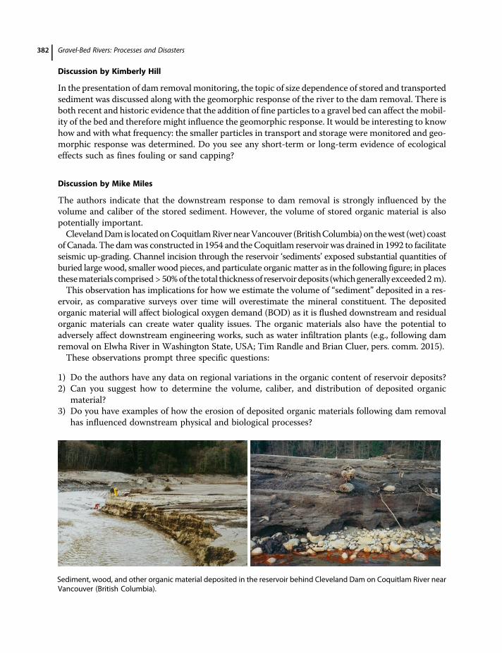
Discussion by Kimberly Hill
In the presentation of dam removal monitoring, the topic of size dependence of stored and transportedsediment was discussed along with the geomorphic response of the river to the dam removal. There isboth recent and historic evidence that the addition of fine particles to a gravel bed can affect themobil-ity of the bed and therefore might influence the geomorphic response. It would be interesting to knowhow and with what frequency: the smaller particles in transport and storage were monitored and geo-morphic response was determined. Do you see any short-term or long-term evidence of ecologicaleffects such as fines fouling or sand capping?
Discussion by Mike Miles
The authors indicate that the downstream response to dam removal is strongly influenced by thevolume and caliber of the stored sediment. However, the volume of stored organic material is alsopotentially important.ClevelandDamis locatedonCoquitlamRivernearVancouver (BritishColumbia) on thewest (wet) coast
of Canada. The damwas constructed in 1954 and theCoquitlam reservoir was drained in 1992 to facilitateseismic up-grading. Channel incision through the reservoir ‘sediments’ exposed substantial quantities ofburied large wood, smaller wood pieces, and particulate organicmatter as in the following figure; in placesthesematerials comprised > 50%of the total thicknessof reservoirdeposits (whichgenerally exceeded2m).This observation has implications for how we estimate the volume of “sediment” deposited in a res-
ervoir, as comparative surveys over time will overestimate the mineral constituent. The depositedorganic material will affect biological oxygen demand (BOD) as it is flushed downstream and residualorganic materials can create water quality issues. The organic materials also have the potential toadversely affect downstream engineering works, such as water infiltration plants (e.g., following damremoval on Elwha River in Washington State, USA; Tim Randle and Brian Cluer, pers. comm. 2015).These observations prompt three specific questions:
1) Do the authors have any data on regional variations in the organic content of reservoir deposits?2) Can you suggest how to determine the volume, caliber, and distribution of deposited organic
material?3) Do you have examples of how the erosion of deposited organic materials following dam removal
has influenced downstream physical and biological processes?
Sediment, wood, and other organic material deposited in the reservoir behind Cleveland Dam on Coquitlam River nearVancouver (British Columbia).
Gravel-Bed Rivers: Processes and Disasters382
Reply by the Authors
Randle and Bountry comment on four points: (i) Models: not all dam removals need to be modeled,and relatively few removals have been modeled, but we agree that comparisons of physical- andnumerical-model predictions with outcomes from dam removals are needed for removals havingthe potential to advance scientific knowledge. Such comparisons have been done for some removals(e.g., Marmot Dam). The few model comparisons that have been published show promise for predict-ing the nature and pace of reservoir erosion and distribution of downstream sediment. Space limita-tion prevented us from delving into this topic. (ii) Dam height: there are two ways dam heightinfluences geomorphic responses – it affects the amount of water and sediment in storage and it con-trols overall base-level fall. Sediment volume, however, does not necessarily correlate directly withdam height. Variations in upstream sediment delivery, poor trapping efficiency, diverse valley geome-tries, and episodic scour of reservoir sediment can complicate relations between dam height and sed-iment volume. (iii) V∗ and E∗: given the small data set, an order-of-magnitude V∗ threshold is perhapsmore appropriate; E∗ may be a useful predictor if first-year erosion could be roughly estimated, and ifrelations between E∗ and sediment travel distance are robust beyond the small data set for which themetric was developed. More data are needed. (iv) Reservoir sediment composition and aspect ratio:Figure 13.3 shows relations among reservoir sediment composition, aspect ratio, and erosion. Moredata are needed before specific indices can be developed with confidence.Regarding Hill’s comments, several studies monitored post-removal transport of fine suspended
sediment by directly measuring concentrations or by monitoring turbidity. However, such monitoringefforts typically last for relatively short time periods (a few months to a few years). As we noted(section 13.2.2.4) fine sand and mud can infiltrate gravels after dam removal and adversely affectecological conditions despite negligible geomorphic impacts. Gravel mobility is enhanced when finersediment, especially sand, is released by dam removal.Miles points to a significant issue that needs study – the role of organics in dam removal. There are
two types of organics of concern: large woody debris, which can affect reservoir erosion and down-stream geomorphic response, and particulate organic matter, even small amounts of which can affectwater quality. In section 13.2.1 we note that exhumed large woody debris can hinder reservoir erosion;it can also control the location of new bar formation downstream from a former dam site (e.g., Eastet al. 2015). We are unaware of any data that highlight regional variations of organic content in res-ervoir deposits. Without extensive coring or geophysical data from reservoir deposits, we do not knowof any efficient way to estimate the volume, caliber, and distribution of organic material, and dam own-ers may not wish to invest in such surveys. However, this represents an important area of research.
Geomorphic Responses to Dam Removal in the United States 383