1.2 MINERAL EXPLORATION ACTIVITIES
37
This document is made available electronically by the Minnesota Legislative Reference Library as part of an ongoing digital archiving project. http://www.leg.state.mn.us/lrl/lrl.asp I I I • I I • I I I I Volume 2-Chapter 1 EXPLORATION Minnesota Environmental Quality Board Regional Copper-Nickel Study Authors: William A. Ryan Peter J. Kreisman* Prepared under the direction of: David L. Veith Peter J. Kreisman Robert H. Poppe *Please contact Peter J. Kreisman regarding questions or comments on this chapter of the report .. SUBJECT TO '/lEW
Transcript of 1.2 MINERAL EXPLORATION ACTIVITIES

This document is made available electronically by the Minnesota Legislative Reference Library as part of an ongoing digital archiving project. http://www.leg.state.mn.us/lrl/lrl.asp I
II
•II
•IIII
Volume 2-Chapter 1
EXPLORATION
Minnesota Environmental Quality BoardRegional Copper-Nickel StudyAuthors: William A. Ryan
Peter J. Kreisman*
Prepared under the direction of:David L. VeithPeter J. KreismanRobert H. Poppe
*Please contact Peter J. Kreisman regarding questionsor comments on this chapter of the report ..
SUBJECT TO ~rt. '/lEW
TABLE OF CONTENTS
III
•I
IIIIIj
II
Volume 2-Chapter 1 EXPLORATION
1.1 INTRODUCTION AND SUMMARY OF FINDINGS
1.2 MINERAL EXPLORATION ACTIVITIES
1.3 DEFINITION AND PROCEDURE OF A PROGRAM1.3.1 Stage I-Regional Appraisal1.3.2 Stage 2-Detailed Field Reconnaissance of Favorable Area1.3 3 Stage 3-Detailed Surface Appraisal of Target Area1.3.4 Stage 4-Detailed 3-Dimensional Sampling and Preliminary
Evalua tion1.3.5 Decision Points
1.4 GEOLOGIC EXPLORATION TECHNIQUES1• 4. 1 Drill i ng
1.4.1.1 Drilling SystemsDiamond DrillingPercussion DrillingRotary Drilling
1.4.1.2 Bulk Sampling
1.5 POLLUTION CONTROL TECHNOLOGY
1.6 EXPLORATION CHAPTER REFERENCES

Volume 2-Chapter 1 EXPLORATION
leI INTRODUCTION AND SUMMARY OF FINDINGS
Exploration, as it pertains to the discovery of new mineral deposits, can be
defined as all the activities and evaluations necessary before an informed deci-
sian can be made establishing the optimum size, initial flowsheet, and annual
output of new extractive operations. The purpose of mineral exploration is the
discovery and acquisi tion of new mineral deposi ts amenable to economic extrac-
tive operations now or in the future. A prime objective of mineral exploration
is to find and acquire a maximum number of such mineral deposits at a minimum
cost and within a minimum time~
The importance of exploration in the mineral industry today is highlighted in a
recent report published by the National Academy of Sciences (1978). The report
states that "although the mineral industry relies on technology to a large
degree in converting resources to usable energy and mineral forms, it does not
base its competitive position on technology but rather on control and access to
the best available deposits." The required technology is generally available to
any company at relatively little or no cost. Cbrrespondingly, a company which
purchases the development rights on a proven deposit ,will pay highly for the
security this offers. The real competitive edge goes to the company which suc-
ceeds in exploration, whether the company subsequently develops the deposit
itself or leases its rights to another. A corrollary of this fact is that
exploration information typically is highly proprietary, especially in the early
and intermediate stages prior to the acquisition of land ownership or lease
rights by the company.
1
PRELrMJNARVSUBJECT TO REVIEW

Exploration is undertaken by a company at great expense in order to obtain rela-
tively simple information on the composition of subsurface rocks. Once this
information becomes public knowledge, the company loses any advantage it had in
possessing the information, unleHs it has already acted to secure its position ..
As a result of this situation, detailed exploration data is often difficult to
obtain, which is unfortunate from the point of view of a systematic advancement
in an understanding of the geology of the state, as well as other environmental
conditions such as water quality which may be strongly influenced by geology ..
Under present laws, all copper-nickel exploration information gathered in the
state by private interests remains confidential, at the discretion of each com-
pany, unless the information pertains to state or federal mineral lands on which
the company relinquishes its lease or permit rights.. It must be noted that
several companies involved in exploration in the Study Area have departed from
normal practice in voluntarily providing considerable information requested
during the course of the Regional Copper-Nickel Study. Company cooperation with
study staff was exceptional, both on the part of companies engaged solely in
copper-nickel exploration, and those ,uso active in iron mining in the region.
The information thus provided is central to much of the work presented
throughout this entire report, and reveals the potential value of exploration
data to the understanding and prevention of possible environmental impacts. IIUnder today's regulations, most environmental impact analysis for new operations IIis conducted prior to facility construction.. As a result, much of the infor-
mati on used to determine whether or not various impacts will occur (such as
trace metal pollution) must be collected as part of the exploration process.
Thus, studies designed to collect this information, clearly beyond the immediate
••interest of the economic or exploration geologist, must be conducted and coor-
dinated with the studies under his direction.
2 pr~EL I~,n' r!," nv •C'I I" I'·.)0 LJ.j I I J r .. ;... ','L'\"J
I

•IIIII
The lack of early access to exploration data, the absence of proper notification
that exploration is occurring in a particular area, and the lack of input by
scientific disciplines other than economic geology could result in the loss of
needed data for subsequent environmental impac t assessment and the corresponding
feasibility studies. This lack of data could also lead to regulatory delays and
increased data acquisition costs, as previously completed studies would have to
be repeated (in part) in order to secure the necessary information.
The above considerations should be recognized by the exploration geologist ~ffien
implementing exploration activities.
The high cost of exploration data must be noted, since it represents con-
siderable financial risk to a company. This is particularly emphasized by the
low success rate experienced in the search for viable mineral deposits. For
example, available information (USGS 1975) indicates that a hypothetical mine
requires the expenditure of approximately $2.2 million (based on 1975
information) simply to find and define the areas of mineral resources. This
does not include the costs of defining the tonnage, grade, and economic fessibi-
lity of the deposit. Further data indicates that the average cost to discover a
mineable porphyry copper deposit in the U.S. is $25 million. These two figures
clearly indicate that fewer than one prospect in ten actually proves out as a
mineable deposit. It is reasonable to assume that a similar success rate is
applicable to deposits in Minnesota, clearly emphasizing the financial risks
involved in exploration.
Northeastern Minnesota has a considerable history of exploration for copper and
nickel. It is appropriate to briefly review that history here, to motivate the
discussion of exploration technology and procedures iwhich follows. The
3
PnELr"'/ : ~ " ,\'
SUCJ' j' j'0 r,;.," J;,,,

progression of Cu-Ni exploration in the' state is, in turn, best understood in
the context of the applicable legal framework. The region within the Study Area
most affected by past work, as well as most likely to be affected by present and
future mineral exploration activities associated with the Duluth Cbmplex has
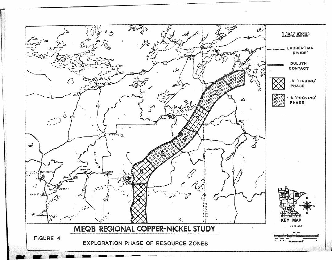
been designated the "Resource Zone" and is shown in Figure 1. The mineral
resources within this 88,600 acre Resource Zone are owned and/or managed by pri-
vate and public interests as follows:
24% Federal Government
15% State Government
32% Private Individuals and Cbrporations
29% Unknown and/or Cbnflicting Ownership
Figure 1
I~I
Private exploration of public resources is governed by various federal and state
laws, rules, and regulations (see Volume 5-Chapter 4 on mineral leases and per-
mits for more information) controlling access; information exchange; environmen-
tal impact mitigation and reclamation; and rents and payments. Exploration of
privately controlled resources (32 to 51% of the Cu-Ni Resource Zone) is not
under the direct perview of government and is controlled by means of private
leases, contracts, or sales. Environmental impact mitigation requirements are
usually not specified in such agreements and Minnesota has no specific authority
requiring that the state be notified of exploration activities on private
I,I
II
••mineral lands. No environmental regulations covering such activities on private IIlands have been promulgated and it is uncertain whether authority to promulgate
such regulations exists.
4PREl1M1NARY
SUBJECT TO REVIEW
••I

11 fa '.~ fQl'~'l\f-..-'
1J:::JU;;~~~~illl
I-=-?~-'M- ;-rc:r " .,m:+'
KEY MAP
,,,,,,,2..,,,1', '.
DULUTHCONTACT
1 -4 ~ ~ "':.. ...
LAURENTIANDIVIDE
I
/~/4"
-0:../
b
_.. --_ ..
OURCE ZONES
~.~--•.--
o
FIGURE 1

The procedures followed in Minnesota by a private interest in order to secure
control of and/or access authorization to federal hard rock mineral resources is
unique as compared to western states because patent claims are not allowed and a
prospecting permit and/or mineral lease must be secured from the U.S. Bureau of
Land Management with approval from the Forest Supervisor if National Forest
Lands are involved. Prior to the granting of mineral leases, prospecting per-
mits are usually issued with or without exclusive or preference rights depending
upon whether the federal lands in question are acquired or public domain lands ..
In Minnesota, the Secretary of Agriculture or his delegate can write into any
prospecting permit or mineral lease for hard rock minerals any stipulations per-
taining to environmental protection and reclamation, but specific regulations
for this purpose have not been promulgated. The Superior National Forest has
adopted minimum guidelines pertaining to environmental mitigation of general
,exploration (exclusive of bulk sampling) activities for copper-nickel resources
in the region between Hoyt Lakes and the BWCA within the Superior National
Forest (see section 1.5) .. The results of exploration activities and processing
tests on federal mineral resources are submitted to the federal government on a
proprietory basis and the information is reviewed and managed by the U.. S.
Geological Survey as agent for the federal government. This information can
only be released to the public or to other agencies of the federal government
upon authorization of the permit or lease holder or upon termination of permits
and leases, at which time the information is placed on open-file.
For state copper-nickel minerals, exploration permits or mineral leases are
granted by the MDNR pursuant to Minnesota Regulations NR 94.. The MDNR admi-
nisters the leasing of state minerals, but the State Executive Council makes the
final authorizations and determines if and when specific tracts ~f state
5
PREL'M'!,~'" ,:V
SUBI'.··· \. - . E" I \"\A'
,)1.- ...... I\...· r... V·I~ .• VY
II;i"I.
II
II,il
1
I..~..!~
••••••
••. j~i;
IIIIIII

I:IIIIIIII
mineral s are to be made available for private leasing and exploration. Resul ts
of copper-nickel exploration and testing activities are submitted on a
proprietary basis to the Minerals Division of the MDNR. This information
remains proprietory to the lease holder and the Minerals Division until the
information is released by the lease holder or when the lease terminates; at
which time the MDNR places the information in open file. In this legal context,
the state's exploration history will now be discussed.
As early as 1854, rumors indicated the presence of copper in northeastern
Minnesota, with nickel findings reported in 1893 (USBM 1976). In the first half
of the twentieth century, some exploration work was done in the region, notably
by the U.S. Geological Survey and the Minnesota Geological Survey. Activity was
low, however, until 1948 when road work on Spruce Road in the Superior National
Forest revealed traces of copper. This was followed by the granting of the
first prospecting permit to Roger V. Whiteside and Fted S. Childers, Sr. in the
Superior National Forest in 1951, and the sinking of the first diamond drill
hole searching specifically for copper-nickel in the same year. By 1954, forty-
one prospecting permits had been issued in the Study Area, and several diamond
drill holes had been put down. The International Nickel Company (INCa) began
extensive drilling in 1954, working under a mineral lease agreement with the
U.S. Bureau of Land Management and the U.S. Forest Service arranged the pre-
vious year. The Bear Creek Mining Company, a subsidiary of Kennecott Copper
Corporation, was al so engaged in surface exploration in the Gunflint area during
the early 19508. In 1966, INca signed a mining lease with the U.Se Department
the Interior, giving INCa mining rights on 4,945 acres of mineral land in the
§uper{or National Forest.
6

The State of Minnesota became active ,in the area of copper-nickel mineral leases
in 1966, with the award~ng of 50-year leases to 11 companies covering a total of
86,605 acres of state-owned mineral lands. Major lease holders included the
Phelps Dodge Corporation, AMAX Exploration, Inc., Bear Creek Mining Company,
u.S. Steel Corp~ration, Cleveland Cliffs Iron Company, Warren S. Moore, and
Duval Corporation. Subsequent state lease sales, held in 1968, 1970, and 1971
added other companies, such as Exxon Company, U.S.A. and American Shield
Corporation to the list of those active in the state.
As a result of these prospecting permits and mining leases granted along the
Duluth Gabbro contact, the Study Area has experienced a great deal of explora-
tion activity over the past two decades. In addition to aerial and surface
work, an estimated 1,000 to 1,500 holes have peen drilled. Several sites have
been explored in considerable detail, including extensive drilling and bulk
sampling. Consequently, the types of exploration techniques applicable in thej
Study Area are well known, and there has been opportunity to directly study the
environmental impacts from these activities. This contrasts strongly to the
situation in mining, processing, and smelting/refining where no actual industry
is currently operating in Minnesota and the potential impacts must be inferred
from the study of other operations around the world. In fact, since many
aspects of an exploration program simulate a full scale operation, several
excellent opportunities have been afforded to understand possible mining impacts
through studies of these activities. This is particularly true of the later
exploration stages which involve activities such as surface storage of rock, and
site water management. The findings from these st~dies will be presented
throughout subsequent volumes of this Regional Study report. Similarly, the
following discussion of the exploration process focuses on techniques applicable
7
PRELIMINARYSUBJECT TO H~VIEW
r
I;
t~-1
-IiIIII
••II

.. 2 MINERAL EXPLORATION ACTIVITIES
mental impacts ..
and following it in the sequence
PRELlMIf\J /\r~Y
SUCJeCT TO kEVIEW8
Subsequent activities generally associated withshown at the top of the figure
A general line diagram of mining activities is shown in Figure 2.. The explora-
time and money are concerned. Another point to be emphasized is that all phases
tion program is primarily involved wi th the "finding" and "proving" ac tivities
an operation are also shown in this figure to emphasize the fact that explora-
tion, although important, is a very small portion of the total picture where
to Minnesota and highlights those of particular concern for potential environ-
tion.. Each stage must, in fact, constantly be concerned with stages preceding
of the exploration program must consider all subsequent stages of a viable
operation, including environmental controls and subsequent. long-term reclama-
sequence of stages, going from the general exploration of large ~reae using
The finding and proving activities in any mineral venture follow a logical
indicator techniques to specific areas in which results of more detailed
investigations indicate greater possibilities of economical mineral deposits.
These exploration stages as shown in Figure 3 are:
Stage 1.. Regional Appraisal
Stage 2.. Detailed Reconnaissance of Favorable Area
Stage 3.. Detailed surface Appraisal of Target Area
Stage 4. Detailed 3-Dimensional Sampling and Preliminary Evaluation
Figure 3

- FIGUHE 2SCHEMATIC DIAGRAM DEPICTING THE SCOPEOF MINING ACTIVITIES FROM EXPLORATION
TO FINAL MARKETING OF THE OUTPUT
CONSUMERIPRODUCTS
----_.. _------ ............. -_ ....... _-------GEOLOG.AMPLING
~ io I.Ja: )
~ Io 01o
od I~ 4
81CJ Q
~~~Iz .:.J
OJ
~I>....J0:0
~IW o~I..... ,~<C 'I-;:-
~I-z
~I<C zcd rl'.....zw:2UJCJZ<C:2
"'IIIIIIIIIIIl
PLANNINGSELECTION Of
MINING METHOD
I. fACILITY
REQUIREMENTS.
.DESIGN I
ENGINEERING
----------------
MINERAL DEPOSITGEOLOGY
MINERALOGY
MINING METHOD
MINERAL PROCESSING
ECONOMICS
ENVIROMENTAL
CONTROLS
~~
PROVING1--------------__ CLOSE DRILLING
SHAFTING AND/OR
TUNNELING
EVALUATION
MININGBREAKING
LOADING
TRANSPORTING
COST CONTROL
IORE FOR TREATMENT
MARKETINGPRODUCTS FOR
FABRICATION OR
OTHER END USES
PROCESSINGCONVERSION Of
MINERAL RAW
MA TERIALS TO
CONSUMER PRODUCTS
FI.NDING·REGIONAL GEOLOGY- - ..... ..
GEOCHEMISTRY\ . .. ~
GEOPHYSICS. ~ _..- - - -
DRILLING
SAMPLING
OPENING ANDDEVELOPINGSHAFT SINKING
&. TUNNELING
STRIPPING
UNDERGROUND &.
SURFACE
CONSTRUCTION
_ r~ ~ _
(!)ZZ~
ol-
IZW:JoWenCD:Jen
(!)Z-Z-~
oI-
a:o-a:Q..
a:UJQ..oa:Q..
(!)Z-Z-::E

3
STAGE 1 STAGE STAGE 3\
STAGE <4
DETAILED DETAILED SURFACE DETAILED 3-DIMENSIONAL
REGIONAL RECONNAISSANCE
APPRAISAL APPRAISAL OF SAMPLING AND PRELIMARYOF FAVORABLE
AREAS TARGET AREA INVESTIGATION
STAFF STAFF STAFF STAFF
1-10 &-20 5-20 20-&0
COST COST COST COST
10-50X1 $50-200X1 $50-200X1 $3-15X1
TIME SPAN TIME SPAN TIME SPAN TIME SPAN
0-1 YEAR 1-2 YEARS 1-2 YEARS 3-5 YEARS

,...
Each of these steps will be briefly di,scussed later"
The definition of explor~tion used here, that of all activities required prior
to the decision to actually develop a producing mine, is quite broad" It is
useful to subdivide this into the two activities of "finding" and "proving," as
shown in Figure 3" "Finding" includes all of the activities listed in stages 1
to 3, and some of the activities of stage 4, notably some preliminary drilling.
As noted earlier, this phase typically might cost $2 million, with less than one
prospec t in ten resul ting in the development of an ac tual mine" The "proving"
phase then proceeds on promising finds, with extensive drilling, bulk sampling,
pilot plant testing, and feasibil,,.ity evaluations" This phase, with highly
variable costs typically ranging from $3 million to $IS million, is only under-
taken on those relatively few finds which show a high degree of promise for
development in the near or medium term future, typically S to IS years.. The
finding phase itself may require 3 to 5 years, with another 3 to S-year proving
period. No data has been found on the success rate of projects once they enter
the proving phase. However, it is fair to say that if the preliminary drilling
of the finding phase shows promise, and the program progresses completely
through the proving phase with its attendent high costs, the most appropriate
question is not whether the deposit is worth developing, b~t when. With a.substantial investment in the site, even though the results may not indicate a
profitable operation at current metal prices, the company is not likely to
totally abandon control of the site. Unless restricted by lease terms or prohi-
bitive royalty paYments, the company is likely to retain its interest in the\
property in hopes that market conditions will justify development in the future.
Actual development may be by the company which conducted the exploration, or by
another company under appropriate development agr~ements.
9
PRELIMINARYSUBJECT TO REVIEW
~
I
~~
I
t
III
I
I
~I
~I

nal Study Area, the work done by INCO in Resource zones 1 and 2 (see
by AMAX in zone 4, and by U.S. Steel in zone 5 qualifies these
in the "proving" phase. The rest of the Duluth Complex, to the
east of zone 1, in zone 3, 6, and 7 as well as the area south to
considered to be in the finding phase. In the Study Area, zone 3
unique in that extensive drilling has occurred in this area as compared to
6 and 7, but a find that warrants increasing activities to the "proving"
phase has not been identified~ For a more detailed discussion of copper-nickel
resources in the Study A~ea, refer to Volume 3-Chapter 2 of this report. As
will be apparent in the following discussion, the potential for environmental
acts is much greater during the "proving" phase than during the "finding"
pnase. Principally, this is due to the drilling and bulk sampling operations,
wi~h their attendent access, surface area, water, and storage requirements.
Figure 4
1.3 DEFINITION AND PROCEDURE OF A PROGRAM
As mentioned earlier, an overall exploration program can be divided into the
"(inding" and "proving" phases. These in turn can be further subdivided into
stages. Each stage is distinguished by the techniques employed. This is a use-
ful basis on which to discuss the overall program since environmental impac ts,
if they result, are caused by the use of particular exploration techniques. The
stages used in the "finding" and "proving" phases are:
"Finding" Phase
Stage 1 - regional appraisal to identify a favorable area
Stage 2 - detailed reconnaiss~nce:of favorable area 'to identify a target area
"10
IE
IN '-FINDING"PHASE
DULUTHCONTACT
1'422.400
LAURENTIANDIVIDE"
- IN "PRGVING'PHASE
Ib~@~~IQ)
KEY MAP
11' I • • • .. 1IDIICIL.OMIIITlIIlIIIlII
""I..IIIID• , I , • • 10
~ ...:"'!fM-
-l§5]
_..-...-
/f(~"
"
,g
c
"-\,
I
,1 y
iii 0, "......... \.!.. ~, . ..
'\ ~.i! \..". i (d I •i '- (~i ..)
6'.~ /00~! ).--...... ..
'- ..,..', ..~~ '-'(l a or~·.'··"'I·~' r·r·- ." . ~.
~. OJ:! ....vi:: i"i=i~ i-j
L L
I
._~ --
~~ ..-""' ....",~ ".. 1''[
c::4
~~C>
-:
EXPLORATION PHASE OF RESOURCE ZONESFIGURE 4
C" ){1!~<1~( v ?
~~~ -~ . ~ rEt~ ~~;:,Z-!. ~-{"' ---~!.- -. " .~ . J'
I .. ~--> i •..-.'" ~.'"I'.· :.~,,-~...J~~ o?l:I '---.r~ ..-: <) ~ t;
oCkl_: •.
I .<""'~~ GO •••••••••••• "". ~---:.:~ ~p' ~~
-- ~- .f:::;~~;:'/"1 ~ - - 5:>.:._
~> ~~OWER

hand appraisal of an area.
surface appraisal of target area
small as 50 square miles. The costs for such a study could
aspects of stage 4, involving preliminary drilling
of stage 4 not undertaken during the "finding" phase,
impacts associated with this stage.
consists of flying over the area and, if accessible by road,
ty of the geology. The area investigated can be as large as 400
11
PRELlM1NI\RYSUBJECT TG F\L VIE'N
initial engineering and cost studies
se stages is discussed below.
stage consists of collecting geologic maps of the area, aerial pho-
$10,000 to $50,000. There do not appear to be any significant
involving detailed 3-dimensional sampling, preliminary evaluation,
through. This is done to determine accessibility of the area, favorabi-
or as large as 10 people working a full summer. The number of person-\
dependent on the size of the area investigated, the detail required, and
Stage 2, Detailed Field Reconnaissance of Favorable Area
and structural maps, along with some field investigation. The field
ty of the geology and topography, and to provide an exploration geologist's
The staff necessary to complete Stage 1 may be as few as one person working for

I
If Stage 1 indicates a favorable area, it is followed by Stage 2 which consists
of locating outcrops from photos and then, if any are found, sampling and
mapping these outcrops~ by surface investigation~ Planes used in conducting such
aerial surveys monitor parameters such as magnetic fields, gravity, and
radiation. If anomalies are indicated by airborne investigations, ground level
geophysical and geochemical tests are used to better locate them. At this time
there is no need for detailed examinations of the anomalies, as this will follow
in Stage 3 investigations. This stage requires a staff of 5 to 20, generally
not much longer than a summer field working season at a cost of $50,000 to
$200,000. The area has now been reduced to 10 to 50 square miles, depending on
the number of anomalies indicated. Again, Stage 2 should not result in any
significant environmental impacts.
1.3.3 Stage 3, Detailed Surface Appraisal of Target Area
Stage 2 has been used to generally locate anomalous conditions in an area. In
Stage 3 these conditions are investigated by detailed geochemical and geophysi
cal testing to spacially outline the anomalies that have been found. In most
cases the same type of geochemical and geophysical tests used in Stage 2 are
used again along with additional testing methods such as induced polarization.
The data from all the tests would show whether ap anomaly exists, its extent,
and if copper-nickel mineralization is the reason for the anomaly. At this
point, the area remains about the same size as outlined in Stage 2, as will the
costs. The manpower requirement may be somewhat higher but for a shorter period
of time. Again, no significant environmental impacts are expected.
12
\ ·r··
.. ,L ''i it... v\/.
iii i-~~--------

Decision Points
lion is reasonable.
3-Dimensional Sampling and Preliminary Evaluation
The environmental impacts resulting from this stage are par-
In addition, a drilling program can provide important environ-
every preliminary indication that a present or future economic
most expensive stage of an exploration program is not started
assessment information such as the type, distribution, and extent
s and fibrous minerals, and the quality and quantity of water pre-
concentrating characteristics. Once again, special atunies could
eoonomics, there are two options the cpmpany can follow. If the
the existence of such an ore body, and is a major part of the Stage 4
important to consider. Drilling is the method universally used to
The drilling will also provide geologic information needed in planning
operation, such as the deposit's shape, size, grade, depth, and type of
ted at this stage pertaining to environmental matters. In total, Stage
13
bedrock aquifers. If the drilling results warrant, bulk samples are
during this stage and subjected to bench scale and pilot plant tests
PRELIMIN/\RYSUBJECT TO REVIEW
exploration program may involve 20 to 50 full-time employees for several
is unfavorable, the area may be completely rejected. On the other hand,, I
\
program continues from the first stage to the fourth, decisions to go on
stop are made at the completion of each stage. If the program proceeds,
tive, for reasons such as unfavorable geology, taxes, poli tical si tuation,,9
depending on the intensity and depth of the drilling requirements and bulk
is being increased. If at the end of the first stage the region is not
area that is being investigated is being reduced in size and the favorabi-
sampling activities. Costs will vary greatly, so that a range of $3 to $15

if taxes, politics, etc. are the reasons for rejection, and the company feels
the geology indicates the area may have mineralization, then the project could
he put into a hold statu's. This means the region would not be attractive at
this time, but with changes in the unfavorable situation it could be of interest
at some later date.
After the second stage has been completed ,-the decision to go ahead, reject, or
put a hold on the project is again made. Total rejection would occur if no
indication of potentially economic mineralization is found. The hold decision
would be made if mineralization or anomalies are indicated, but not of a grade
or size the company deems necessary to continue exploration. The go ahead deci-
sion leads to Stage 3.
When Stage 3 has been reached and completed the same three options are available
again. The property would be rejected if, under closer scrutiny, the anomalous
conditions indicated in Stage 2 proved not to be due to potentially economic
minerals. The geophysical and geochemical tests may have indicated mineraliza-
tion but not enough to go ahead to Stage 4. Still, sufficient mineralization
might be found to keep interest up and the hold option could be used.
At Stage 4, land control plays a major role in whether or not a company will go
ahead with more exploration. If a company cannot obtain control (via leases or
direct ownership) of the area they are exploring, they will not go into the 3-
dimensional exploration of Stage 4. If in the future the area does become
available, the project could then go from hold into Stage 4, and drilling would
commence.
The decision to continue may also be made at other times particularly following
preliminary drilling in Stage 4. This corresponds to the end of the "finding"
14
PRELl !\!i 1;" \f:Y
SUBJECT TO REVlCN I

I
phase. At this point, the resulting information is used to determine whether to
proceed' to the "proving" phase, and if so how much more drilling is needed. If
mineralization is found but determined uneconomical at the time, the area is put
on hold. This may, for example, be due to grade, recovery, or other processing
problems. Also, the deposit could be either too small or too large. If the
deposit is too small for a particular company, a company with lesser demands may
be encouraged to take over the property. In the case of a deposit being too
large, two or more companies could pool capital and technology for a joint ven-
ture.
1.4 GEOLOGIC EXPLORATION TECHNIQUES
The exploration geologist has access to hundreds of exploration techniques.
Table 1 is a summary of the general techniques available for each stage of an
exploration program. The general nature of most of these activities are
apparent from the comments shown in the table.
Table 1
Most of the techniques do not have significant environmental impact potential
and so need not be discussed further. However, two of the Stage 4 activities,
drilling and bulk sampling, could result in significant impacts. Therefore,
these rather complex activities are discussed in more detail in the following
section..
1.. 4. 1 Drilling
is the operation of sinking deep holes for prospecting, exploration, or
Two general methods of drilling are common: 1) percussion systems,
15

Table 1. Geologic exploration techniques.
EXPLORATIONSTAGES
RegionalAppraisal(Stage 1)
DetailedReconnaissance(Stage 2)
DetailedSurfaceInvestigationof TargetArea(Stage 3)
ACTIVITY OR METHODUSED TO, COMPLETE
THE STAGEa
o - Geologic compilation
o - Photogeologic study(rock units, contactsand struc tures)
o - Structural analysis
F - Field inspection of area
F - Reconnaissance geologicmapping of outcrops
F - Stream sediment geochemical surveys
F - Airborne electromagnetic survey
F - Gravity survey ingravel-covered area
F - Reconnaissance inducedpolarization survey ofcovered area
F - Field inspection ofanomalous areas
F - Detailed geologicstructural-alterationmapping of outcrops
L - Petrographic-mineralogytrace element s~udy ofrock samples
F - Detailed i~duced polarization survey ofanomalous covered areas
",:--1'
DESCRIPTION OF ACTIVITY OR METHOD
These techniques are all performedthrough the use of airplanes,helicopters, and motorizedvehicles. The choice will dependon the terrain and accessibilityof an area.
A field camp is required if accommodations are not readily available
Small motorboats would be used totransport personnel in collectingsamples
A plane or helicopter is flown overthe area on a predetermined grid
This is performed on the ground.There will be very little siteclearing associated with this
This will require clearing a path
The use of a plane, helicopter, ormotorized vehicle will be required
A field camp is required if accommodations are not readily available
A building would be required tostore samples and perform the labwork
Four-foot-wide paths would becleared on a grid over theanomalous areas
1111~;I.
•IIIl"l!I;
:J1
111I!
I
PRELIMINARYSUBJECT TO REVIEW

EXPLORATIONSTAGES
ACTIVITY OR METHODUSED TO COMPLETE
THE STAGEa DESCRIPTION OF ACTIVITY OR METHOD
o - Reserves computation
o - Preliminary valuation
Mineable tons would be estimated
The stream sediments would be sampledusing small motorboats.. The soilsamples will be taken along the samegrid used for the induced polarisurvey
Estimations of profitability are made
Drilling will be carried out by theuse of one of three drilling typeshammer drills, rotary drills, ordiamond core drills
These tests will give neededinformation for the reserve estimateand preliminary valuation
Samples of a few tons to thousandsof tons are taken for testing
This would include estimates of waterthat would flow into a pit or underground mine or other conditions thatwill pose problems to a miningoperation
Drill holes are surveyed to confirmlocation and deviation, andgeophysical tests for indicationsof mineralization are done
Lab work that in most cases willbe performed off-site
This would include overburdentesting for depth variability and'favorabili ty for construe tion
F - Detailed stream sedimentand/or soil geochemicalsurvey
F - Investigation of suitability of ground forplant, waste. disposal,and town si tes
I' \
F - Shaft sinking, tunnelingor surface bulk sampling
F - Investigation of waterproblems and wateravailability for plants
F - Down-hole geophysicalsurveys
L - Ore dressing tests onbulk samples
L - Mineralogical and chemical analysis, and physical. tests on samples,cores and cuttings
aO - Office study .f! .
F - Field investigationL - Laboratory test
Stage 3 (contd)
Detailed Three- F - DrillingDimensionalPhysical Samplingof Target Area(Stage 4)
I
I

concern» with samples for laboratory testwork
weathering cycles» rock types» alteration, etc.
Drilling is typically directed toward determining the grade» volume» and shape
li:'REt !J.."~~.t.'l· -'\I'
,~)lH\.".f_i. .,' ~ -.f t,~.·/ ,l.n·
16
Exploration information gathered before the drilling begins is used to determine
which consist of breaking up the ground by means of repeated impacts using a
sharp-pointed instrument; and 2) rotary systems» which employ abrasive grinding
and may aim at the extraction of an intact core or permit all the disintegrated
material to be washed away.
1.4.1.1 Drilling Systems--There are a number of drilling systems. A short
definition plus the advantages and disadvantages of each major system is listed
below.
which of the numerous drilling methods and techniques should be used to provide
the best data on which to make the required decisions concerning the economics
of an ore deposit. The cost involved in a drilling program and the accuracy of
the information gathered depends on the amount and type of drilling, and the
geology of the area under investigation.
of a mineralized zone that has been generally located by prior detailed surface
investigations. Information provided by such a program may include:
4) Shape of the ore zone
5) Physical properties of the ore and host rock
6) Occurrence of mineralization and its dependence on structure»
7) Structural occurrence and quality of groundwater
8) Depth and nature of overburden
1) Geologic framework of the deposi t
2) Variations in grade of potential ore and waste materials
3) Distribution and mineralogy of the minerals of economic and environmental

ilIIIII~~il:1I
s method involves a rotary drilling machine using equipment
and tools designed to recover rock samples in the form of cylind rical cores from
rocks penetrated by boreholes~ This Is done by using a diamond-inset annular
bit as the cutting tool. This tubular bit and attached core barrel are rotated
under controlled pressure by means of hollow steel, flush-jointed rods, through
which water is pumped to cool the bit and remove rock cuttings. With the
advance of the bit, a cylindrical core of rock passes up into the core barrel,
where it is held by a core lifter or other device for periodic removal.
This type of drilling has the distinct advantage of producing an intact core
that can be brought to the surface for study. In competent rock, core recovery
approaches 100% and will show orientation and thickness of rock units, rock
fractures, competence, and mineralization. Additionally, the core results in a
sample for metallurgical testwork to evaluate processing techniques. The cost
of diamond drilling is high (approximately $39/meter or $12/foot), and if a core
is not required, the other two methods) which are less expensive, can be used to
produce drill cuttings for sampling.
In poorly consolidated or highly fractured material, core recovery may approach
zero, and what is recovered provides a poor indication of the type of materialI
being drilled. Under these conditions another type of drilling should be used
to provide a more representative sample of the formation.
Percussion Drilling--This drilling procedure incorporates a reciprocating
hammer, usually driven by compressed air, striking a rotating bit or a long
column of rotating drill steel that has a cutting bit on the lower end. When
the .reciprocating hammer itself is located at the bottom of the hole, the term
"down-the-hole-hammer drill" is used.. This method produces chips of rocks which
17
PREL\M\NARYSUBJECT 10 REViEW

are blown from the hole by the hammer exhaust air and are collected, sampled,
and tested to give information over the interval that has been drilled. The.main disadvantage of this/method is that there is no solid core for geological
study. Advantages are cost savings (of $3-$6/meter or $1-$2/foot), and faster
drilling rates. Also, unlike diamond or rotary drilling, there is little or no
deviation from vertical of the drilled hole, which eliminates the need for sur
veying the hole.
Rotary Drilling--This drilling method consists of rotating a column of drill
pipe, at the bottom of which is attached a drilling bit. Unlike diamond
drilling, no solid core is produced, but rather a flow of rock chips, or cut
tings. During the operation, mud-laden fluid is circulated down through the
drill pipe under pressure by means of special slush'pumps. The drilling mud and
cuttings from the bit are forced up the outside of the drill pipe to the surface
where the cuttings are collec ted for' examination. Wi th both the rotary and per
cussion methods, care has to be taken to ensure that all the cuttings have been
brought to the surface from each drilling interval so they do not contaminate
the sample collected in the next drilling interval.
1.4.1.2 Bulk Sampling--Bulk sampling, as the name implies, is the collecting of
a large sample for bench-scale testing or pilot plant study. Cbllection of this
sample is done in a pit, trench, shaft, or tunnel depending on the location of
the mineralization.
The high cost of underground work precludes shaft and tunnel methods of sampling
if other procedures can be used. Pits and trenches produce satisfactory infor
mation in areas where there is little overburden and the ore zone is near the
surface.
18
PREL.1 ~ .."lNARYSUF3JLCT TO REVIEW
I"-:~',I'I
I
II·
IIIIIII

II\1I
~I
I
bulk sample is taken to provide sufficient material for metallurgical analy-
sis and for verification of drilling program results. This information will
enable mill and smelter design work to proceed in the most reliable manner.
The size of the sample can vary from a few hundred pounds to thousands of tons,
depending on the work that will be done on the sample. In the COpper-Nickel
Study Area, for example, six bulk samples have been taken; three by INCO, one by
u.S. Steel, and two by AMAX. To show how sample size can vary, to date AMAX has
utilized approximately 3,000 st of some 20,000 st of mineralized material
removed from the underground drifts at Minnamax. Of this 3,000 st used for con-
centration and smelting tests, sub-samples of 1,000 st and 300 st were sent to
governmental agencies. The remainder is being held in reserve for possible
future testwork. In addition, AMAX has taken an open pit bulk sample of some
1,100 st for testwork. The U.S. Steel bulk sample was 300 st and INCO's samples
were, respectively, 50 st from a surface site, followed by 10,000 st each from
an underground site and another surface site.
1.5 POLLUTION CONTROL TECHNOLOGY
Table 2 lists potential pollution areas, mitigation measures, and effectiveness
of such measures for each exploration stage. Such a comparison is highly
qualitative; however, it is useful in pointing out generally the distinction
between sources of pollution for which effective controls exist and those for
which controls are only partly effective or non-existent.
Table 2
Exploration has very few significant environmental impac ts associated wi th it in
three stages. The fourth stage involves i several activities, notably
19
p~;'r~ fl","'NI\'0V .., ':'" ~ , , t\]

'L~
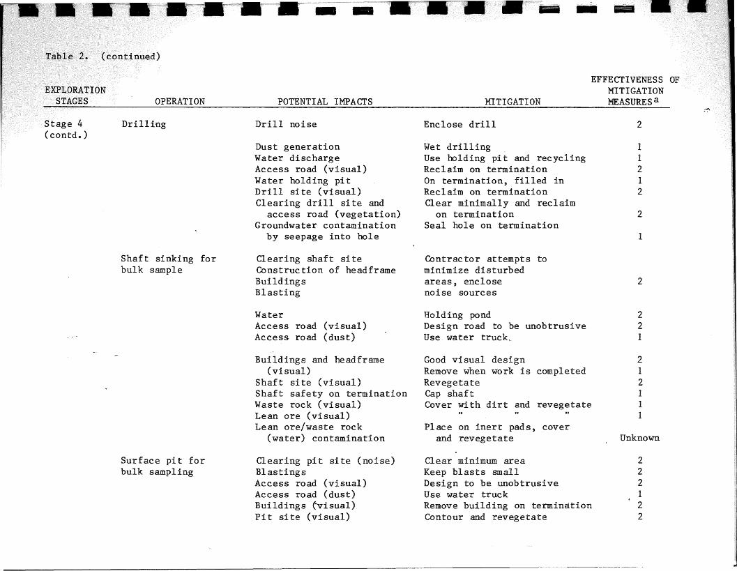
Table 2. (continued)
EXPLORATIONSTAGES OPERATION POTENTIAL IMPACTS MITIGATION
EFFECTIVENESS--OFMITIGATIONMEASURESa --
Stage 4(contd)
Surface pi t andbulk sampling(contd.)
Pit site (water contam-ination)
Waste rock (visual)Lean ore (visual)Lean ore/waste rock
(water contamination)
Fill with overburden andrevegetate
Cover with dirt and revegetateII
Place on inert pad, cover withdirt, and revegetate
211
Unknown
1: Good-proven effective control technology exists and is known to operate reliably in many installations.2: Fair-proven effective control technology exists or is in the demonstration stage at one or more
installations.3: Poor-proven effective control technology has not been developed or is not yet ready for full-scale
operation.
\\;, \~ 11 i .; I ~",., '" , ..,( ; ~ .... I - t
1
2
11212
2
EFFECTIVENESSMITIGATIONMEASURES a
-.-
Wet drillingUse holding pit and recyclingReclaim on terminationOn termination, filled inReclaim on terminationClear minimally and reclaim
on terminationSeal hole on termination
Enclose drill
-~~--. --
Drill noise
Dust generationWater dischargeAccess road (visual)Water holding pitDrill site (visual)Clearing drill site and
access road (vegetation)Groundwater contamination
by seepage into hole
Drilling~ 4(contd.)
Shaft sinking forbulk sample
Clearing shaft siteConstruction of headframeBuildingsBlasting
Contrac tor attempts tominimize disturbedareas, enclosenoise sources
2
WaterAccess road (visual)Access road (dust)
Holding pondDesign road to be unobtrusiveUse water truck..
221
Buildings and head frame(visual)
Shaft site (visual)Shaft safety on terminationWaste rock (visual)Lean ore (visual)Lean ore/waste rock
(water) contamination
Good visual designRemove when work is completedRevegetateCap shaftCover with dirt and revegetate
Place on inert pads, coverand revegetate
212111
Unknown
Surface pi t forbulk sampling
Clearing pit site (noise)BlastingsAccess road (visual)Access road (dust)Buildings (~isual)
Pit site (visual)
Clear minimum areaKeep blasts smallDesign to be unobtrusiveUse water truckRemove building on terminationContour and revegetate
222122

Table 2. (continued)
EXPLORATIONSTAGES OPERATION POTENTIAL IMPACTS MITIGATION
EFFECTIVENESS OFMITIGATIONMEASURES a
Stage 4(contd)
Surface pi t andbulk sampling(contd.)
Pit site (water contam-ination)
Waste rock (visual)Lean ore (visual)Lean ore/waste rock
(water contamination)
Fill with overburden andrevegetate
Cover with dirt and revegetate..Place on inert pad, cover with
dirt, and revegetate
211
Unknown
1: Good-proven effective control technology exists and is known to operate reliably in many installations.2: Fair-proven effective control technology exists or is in the demonstration stage at one or more
installations.3: Poor-proven effective control technology has not been developed or is not yet ready for full-scale
operation•
• I. • • • " ,,'I' '""'11"" ,,)

sampling, which necessi tatn precautionary measures on the part
the exploration companies and equipment operators whom they employ. For
example, problems may result from the fact that drilling rigs require road
access to each site. Existing roads must invariably be augmented, usually by
Iclearing or bulldozing access roads 10 to 14 feet wide along which the drill rig
is skidded. In addition, each drill site may occupy a plot 50 feet on a side.
As a result, a detailed drilling program of 150 to 200 holes in an area of 2 to
3 isqua.re miles may involve the direct disturbance of 25 to 30, acres. Much of
I
this may be temporary, with natural vegetation returning relatively rapidly.
, the recovery of certain areas, particularly drill sites, may take deca-
des 'if the use of lubricants and management of drill cooling systems are not
carefully controlled, wi th proper cleanup following si te abandonment.
Drilling can produce water that has oil, drilling mud, and high levels of
dissolved solids. The common procedure with rotary and diamond drills is to dig
two small holding pits (e.g. 3 m X 3 m), called mud sumps. The water from
Idrilling is pumped into the first pit which functions as a settling pond. The
overflow runs into the second pit and is then recycled. In instances where a
20
drilling is used, due to the nature of this type of
However, impacts can be prevented if the operator shuts the rig down
and chloride. There is little chance of controlling this water when
tered, large quantities (1100 liters/min or 300 gal/min) of water can be blown
PRELIMINARYSUBJECT TO REVIEW
remove cuttings. However, if conate water (water trapped in bedrock) is encoun-
have dissolved solids three orders of magnitude higher than background well
from the hole along with hammer exhaust air. These waters have been observed to
down-the-hole-hammer drill is used, water is not required to cool the drill or
. water. This may be due, for example, to elevated levels of calcium carbonate,

when wa~er is encountered, and finishes drilling with a rotary or diamond core
drill which will minimize the discharge.
Access road and drill site reclamation, as already noted, 1S best served by
intelligent planning and operation during drilling. The length of roads
contructioned can be minimized, and minimum widths used. Where possible,
bulldozers should minimize removal of topsoil, in order to shorten natural reve-
getation time. Sites should be kept as small as possible, with the avoidance of
discharges of oil, groundwater, and other materials not native to the area.
Following operation, all foreign material should be removed, and the drill hole
should be carefully sealed to prevent seepage of water either into or out of the
hole (should it be artesian). Any sumps should be filled, and topsoil replaced.
Both sites and roads will recover more rapidly if some artificial revegetation
is used to speed up the return of natural plant communities.
As a specific example, an Environmental Analysis Review conducted by the U.S.
Forest Service on proposed mineral exploration work in the Duluth Gabbro Complex
in the Ely-Hoyt Lakes area (Behling and Sweet 1975) contains a list of guideli-
nes which must be considered when approving operating plans for mineral explora-
tion. The guidelines are minimal, and are intended to be used along wi th all
other factors that will help to eliminate or mitigate adverse environmental
impacts. These guidelines include:
1) Roads to be used for access to exploration sites shall be constructed or
reconstructed to a standard commensurate with the period of planned use.
Adequate cross drainage, spot surfacing and turnouts will be provided to insure
control of erosion and protection of water resources and provide user safety.
21
PREL\M\NARYSUBJEST '\'U hlVICv\(
I",,"f,.'
IiI
1_-,1,';
j
II

state, county, or forest roads will require a side
of navigable streams will require the permittee to obtain a
permit issued by the State of Minnesota.
sump and catchment basins will be provided at each drill site to
from lakes, streams, and water sources: to prevent contamination.
runoff from drilling operations and will be located a sufficient
officer or his representative.
All operations will be conducted so as to minimize the adverse impacts on...
Access routes will be on locations approved in advance by the authorized
streams, lakes, ponds, waterholes, seeps, marshes, and fish and wildlife resour-
ces. Occupancy of the surface in deep marshes, shallow marshes, and sedge
meadows will be prohibited.
I 7) Access points from main roads will require a minimum of 200 ft, 6 in. deep
of gravel from the point of intersection unless access is to be wholly on fro-
zen, snow-covered ground.
8) Operations under the permit will require and provide for adequate fire
protec tion.
9) Restoration of drill sites will include complete cleanup, debris removal,
landscaping, and revegetation of disturbed areas including access roads.
Acceptance of restoration will be delayed until the disturbed area is revege-
tated to acceptable grasses, legumes, or natural shrubs and trees. In areas of
high erosion potential, the restoration and revegetation will be accomplished
22
PHEt', \~ 1~·! :'\.~-)y
SUBJECT i U t~L.\)iL'N

concurrently with the operation but in no case will it be delayed beyond the
next full growing season.
10) Exploration drilling may be permitted within 400 ft of stre&ns~ lakes,
reservoirs, and wetlands, if seasonal operations will mitigate the impacts on
the environment and other forest uses; and/or, if drill sites are located and
constructed so as to prevent drilling solutions from entering surface runoff.
11) If casing is left in the drill hole, it will be firmly set in the bedrock
and tightly capped to avoid transfer of water between aquifers and between sur-
face and ground waters. Capped drill holes will not extend more than 6 in.
above the surface of the local ground surface.
12) A brief description of all drilling fluid adciitives and their possible
environmental effects will be submitted in advance to the Forest Officer in
Charge or his authorized representative for approval.
13) No drilling will be permitted within 10 chains (660 ft) of an active eagle
or osprey nest.
14) Before specific areas are to be occupied, or otherwise disturbed, a recon-
naissance check will be made by the Forest Service to determine whether the
areas are suspect of having archeological significance. If such is the case,
suspect areas will either be avoided or further evaluated by a professional
archeologist to determine whether disturbance could be permitted.
Bulk sampling is al so conduc ted during the fourth stage. Wi th ei ther surface or
underground bulk sampling, typically 5 to 10 acres of surface land would be
disturbed, at least temporarily. Surface samples may be taken by digging a pit
which can be refilled and contoured. Minor amounts of water may have to be
23
I~II
~j!dj
IIIIIIII~

pp [1 r~." ~ ~ ~ :', c-'y~::; 1. ~ f:""' . r,' r ' . "',;
pumped from the pi tduring thei sample taking to maintain good working con-
d i tions. If the bulk sample is taken at depths of more than a few hundred fee t ,
a shaft will have to be sunk. Waste rock from this shaft will have to be stored
above pumped from the shaft will have to be disposed of
or This shaft water may be high in constituents such
may necessitate treatment before discharge if associated
avoided. Runoff water from the rock piles may also be stored
if this water is of poor quality as a result of the leaching of
s and sulfate from the piles. The conditions affecting the nature
rate of this leaching are not yet well understood. Therefore, it is not now
possible to specify with assurance the mitigation measures which will result in
the elimination of possible leaching and resultant environmental impacts.
Many of the long-term reclamation practices mentioned with respect to drilling
also apply to the bulk sample sites. In addition', buildings, parking lots,
headframes, and other artificial structures should be removed and natural top
soil returned to the affected areas prior to revegetation. Waste rock piles
should receive special attention to be sure they are isolated from leaching ,into
surface or groundwaters. This might be accomplished in certain cases (in which
only a small amount of waste rock is produced, for example) by returning wastes
to an underground shaft prior to securely capping it. Piles might be placed on
inert pads isolated from ground water, and be sealed with a relatively imper
vious layer of material such as clay, to prevent surface water infiltration.
The protected piles could then be revegetated to protect the seal. However, the
successfulness of such measures are not well known. For ultimate elimination of..,
possible impacts, all waste rock might simply be removed from particularly
sensitive areas along with the bul~ sample itself. Clearly,
24
I
I
III

with proper planning and execution, it ~ppears to be technically feasible to
greatly reduce, if not eliminate any significant long-term environmental impacts
associated with exploration.
•••I;,
••~.
Ir,
~
••
25
PREL\M\NARYSUBJECT TO REV\EW
•

EXPLORATION CHAPTER REFERENCES
II
General
American Institute of Mining, Metallurgical, and Petroleum Engineers, Inc.1968. Surface New York , NY ..
underground mining methods prepared forContrac t No. 50122059.
, Volume 1. Society of Mining Engineerstute of Mining, Metallurgical, and Petroleum
New York, NY. 1973.
Agriculture. 1977. Anatomy of a mine from prospect toIntermountain Forest and Ranger Experiment Station,
, u.S. Department of Agriculture. Ogden, Utah. GeneralRepprt Int-35 ..
, S.. and B.T. Sweet. 1975. Environmental analysis review. SuperiorNational Forest ..
Comparative study of Canadian-Un! ted States resource programs, Office ofResource Analysis, U.S. Geological Survey, May 9, 1975.
Northeastern Minnesota copper-nickel development chronology. LiaisonOffice, U.S. Bureau of Mines, January 23, 1976.
iTechnological innovation and forces for change in the mineral industry.
National Academy of Sciences. 1978.