1077 Warfield Neighbourhood Plan Illustrative Materialwarfield-np.org.uk/images/nhp_AppendixA/1077...
31
january 2017 Warfield Neighbourhood Plan Local Landscape Appraisal Hayley Green, Newell Green and Warfield Street for Warfield parish council illustrative material LanDesign Associates Ref: 1077/Doc 2/ Issue 1 1077 warfield LanDesign Associates Chartered Landscape Architects. The Old Forge, Lower South Wraxall, Bradford-on-Avon, Wiltshire. BA15 2RZ. Tel (01225) 866739.
Transcript of 1077 Warfield Neighbourhood Plan Illustrative Materialwarfield-np.org.uk/images/nhp_AppendixA/1077...

january 2017
Warfield Neighbourhood Plan
Local Landscape Appraisal Hayley Green, Newell Green
and Warfield Street
for
Warfield parish council
illustrative material
LanDesign Associates
Ref: 1077/Doc 2/ Issue 1
1077 warfield LanDesign AssociatesChartered Landscape Architects.The Old Forge, Lower South Wraxall,Bradford-on-Avon, Wiltshire. BA15 2RZ.Tel (01225) 866739.
Local Landscape Appraisal: Hayley Green, Newell Green & Warfield Street.
1077 Fig 1; Site Location
12
3
Google Maps
THIS DRAWING IS COPYRIGHTARCHITECT TO BE NOTIFIED OF DISCREPANCIES
DO NOT SCALE THIS DRAWINGCONTRACTORS MUST CHECK ALL DIMENSIONS ON SITE
LanDesign AssociatesThe Old Forge, 26, Lower South Wraxall,Bradford-on-Avon , Wiltshire . BA15 2RZ.
Chartered Landscape ArchitectsTel/Fax: (01225) 866739office@ldaconsult .co.ukwww.ldaconsult .co.uk
WARFIELD NEIGHBOURHOOD PLANLANDSCAPE APPRAISAL
for rCOHLDA Fig 1 (r1)
WARFIELD STREET, NEWELL GREEN &HAYLEY GREEN,
A3 (DO NOT SCALE)JANUARY 2017
N
Hayley Green
Newell Green
Warfield Street
1
2
3
OS Base Information Crown Copyright 2016
All rights reserved. Licence number 100039908
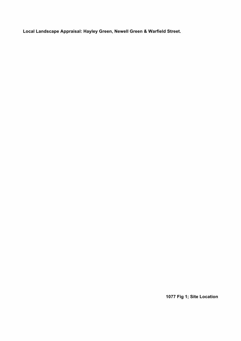
Local Landscape Appraisal: Hayley Green, Newell Green & Warfield Street.
1077 Fig 2; Aerial Oblique View

12
3
Google Maps
THIS DRAWING IS COPYRIGHTARCHITECT TO BE NOTIFIED OF DISCREPANCIES
DO NOT SCALE THIS DRAWINGCONTRACTORS MUST CHECK ALL DIMENSIONS ON SITE
LanDesign AssociatesThe Old Forge, 26, Lower South Wraxall,Bradford-on-Avon , Wiltshire . BA15 2RZ.
Chartered Landscape ArchitectsTel/Fax: (01225) 866739office@ldaconsult .co.ukwww.ldaconsult .co.uk
WARFIELD NEIGHBOURHOOD PLANLANDSCAPE APPRAISAL
for rCOHLDA Fig 2 r1
WARFIELD STREET, NEWELL GREEN &HAYLEY GREEN,
A3 BIRDS EYE VIEW (DO NOT SCALE)JANUARY 2017
N
Hayley Green
Newell Green
Warfield Street
1
2
3
Local Landscape Appraisal: Hayley Green, Newell Green & Warfield Street.
1077 Fig 3; Bracknell Forest Borough Proposals Map 2; Warfield & Winkfield North

✽
✽
959493929189888786
71
72
73
74
75
90
9594939291898887 90
70
71
72
73
74
75
170000mN
486000mE
Sustainable Growth
Quality of Life
Environment
Somewhere to live
Somewhere to work and shop
Transport
Borough-wide Policies
Limiting the Impact of Development
CS21 Sustainable Development Principles
CS6
Recreation and CultureCS8
CS10 Sustainable ResourcesCS11 Renewable Energy GenerationCS12CS13 Sustainable Waste Management
CS15 Overall Housing ProvisionCS16 Housing Needs of the CommunityCS17 Affordable HousingCS18 Gypsies and Travellers
DesignCS7
Renewable Energy CS23CS24 Transport and New Development
Transport
CS19CS22 Out-of-Town Centre Retail Development
Small Employment Uses
Core Strategy Development Plan Document
Built and Natural Environment
Economy
Housing
Movement
Recreation
Services and community facilities
Borough-wide policies
Floodlighting
EN1 Protecting tree and hedgerow coverEN2 Supplementing tree and hedgerow coverEN7 Other Important archaeological remainsEN15
Designing for accessibilityEN22EN25 Noise and other pollutionEN26 Energy
E4 Small businessesE8 Change of use of shop (A1) to other
uses outside defined shopping centres
H3 Residential subdivisions and houses in multiple occupationH8
Retention of housing stockH12 Enclosure of open land in residential areas
M1M4
M5 Service road schemesM6 Cycling and walkingM7 Access for people with disabilitiesM8 Public transport
R3 Dual use of educational facilitiesR4 Provision of open space of public valueR5 Publicly usable open space for small sitesR6R8 Public rights of way
SC3 No reduction in existing community facilitiesSC4
Affordable housing
Traffic management and highway schemesHighway measures expected in associationwith new development
M9 Vehicle and cycle parking
Visitor accommodation
Telecommunications provision
H11
Design considerations in new developmentEN20
Bracknell Forest Borough Local Plan
Scale 1:10,000
PM1.1ix
✽
● ● ● ●
▲▲
▲▲
GB1,2,3,4
EN3ii,3iii,10i
EN3ii,3iii,10i
GB1,2,3,4
GB1,2,3,4
GB1,2,3,4
GB1,2,3,4EN3ii,3iii,10i
EN3ii,3iii,10i
EN6
EN3iii
GB1,2,3,4
EN6
GB1,2,3,4
R8
EN11
EN10ii
CS2(2),CS2(3), CS19
R8
R8
CS9(ii)EN8,15 GB1,2,4
H5 M10 R7
EN10ii
CS8
CS8
EN14
EN14
EN14
EN14
EN14
EN14
EN14
EN14
EN14
GB5CS19 & CS20
EN10ii
EN12
EN12
EN12
EN4
EN4EN4
EN4
EN4EN3iii
EN4
EN4
EN4
EN4
EN14
EN4
EN4
EN4
EN4
EN4
EN4
EN4
EN4
EN4
EN4
EN4
EN4
EN4
EN14
EN4
EN4
EN4
EN4
EN4 EN4
EN4
EN4
EN14
CS5
CS5
CS8
CS8
CS8
CS8
CS8 CS8
CS8
CS8
CS8
CS8
CS8
CS8
CS8
CS8
GB5CS19 & CS20
EN14
CS9(ii)EN8,15 GB1,2,4
H5 M10 R7
CS9(ii)EN8,15 GB1,2,4
H5 M10 R7
GB1,2,3,4
CS2(2),CS2(3), CS19
CS2(2),CS2(3), CS19
CS2(2),CS2(3), CS19
CS2(2),CS2(3), CS19
CS9(ii)EN8,15 GB1,2,4
H5 M10 R7
EN3iii
EN3iiiEN4
EN14
EN3iiiEN10i
CS9EN8,9,15 H5,6
M10 R7
CS2(2), CS2(3), CS19
EN14
EN4
CS9EN8,9,15 H5,6
M10 R7
CS9EN8,9,15 H5,6
M10 R7
CS14
CS14
17
ProposalsMap (Feb 2008)
1 23
map4 overleaf
2 Warfield andWinkfield north
4
Bracknell ForestBorough
Relating to policies in the:- Core Strategy Development PlanDocument (February 2008); and,
- Bracknell Forest Borough Local Plan (January 2002)
2
N
0 100
Metres
SCALE 1: 10,000
200 300 400 500
This map is reproduced from Ordnance Survey Material withthe permission of Ordnance Survey on behalf of the
Controller of Her Majesty's Stationery Office © Crown Copyright.Unauthorised reproduction infringes Crown Copyright. and may
lead to prosecution or civil proceedings.Bracknell Forest Borough Council LA100019488.
Version Published 7th February 2008
Highway Works
Special Area of Conservation EN3ii
Site of Special Scientific Interest EN3iii
Scheduled Ancient Monuments EN6
Land outside Defined SettlementsCS9EN8,9,15 H5,6 M10 R7
Wildlife Heritage Sites EN4
Area of Special Landscape Importance EN10i
Area of Local Landscape Importance EN10ii
Warfield Park Mobile Home Site EN11
River Corridor EN14
Defined Settlements CS2(2), CS2(3), CS19
Green Belt CS9(ii)EN8,15 GB1,2,4 H5 M10 R7
Green Belt Villages GB1,2,3,4
Major Developed Site within the Green Belt GB5
Open Space of Public Value CS8
Ramblers Route R8(a)
Town Centres
Footpath/Cycleway
- proposal numbers are shown in red
Historic Park or Garden EN12
5Km Special Protection Area line(See SPA Context Map overleaf on Map 4)
Bracknell Forest BC Borough Boundary
Major Locations for Growth CS5
CS21
CS14
●
● ●
Map 4 (Sandhurst and Crowthorne) is overleafMaps 1 and 3 are on the other sheet
(Up-to-date Inset Maps can be viewed on-line at www.bracknell-forest.gov.uk apart from Inset 1 shown on map 1)
Digitally produced by E.S.R. Cartography Ltd., Woodley RG5 3LE
Policies
Proposals

Local Landscape Appraisal: Hayley Green, Newell Green & Warfield Street.
1077 Fig 4; Core Strategy Map 3 Key Diagram

A322
A329(M)
M3
A3095
A330
A321
A329
A332 A309
5
A329
A332 A3
095
A321
M4M4
Map 3: Core Strategy Key Diagram
Binfield
Newell Green
Warfield Street
Hayley Green
Winkfield Row
Chavey Down
North Ascot
North RoadWokingham Ascot
Bracknell
South Ascot
Crowthorne
Bagshot M3
Sandhurst 0 1 2 3
Km
Legend Yateley Bracknell Town Centre
Defined SettlementsCamberleyBlackwater Major Locations For Growth
Special Protection Area
Special Area of Conservation
Green Belt
Strategic Gaps
Local Gaps
BFBC Borough Boundary
A Road
MotorwayThis Map is reproduced from Ordnance Survey Material with the permission of Ordnance Survey on behalf of the Controller of Her Majesty's Stationery Office © Crown Copyright. Unauthorised reproduction infringes Crown copyright and may lead to prosecution or civil proceedings. Bracknell Forest Borough Council LA100019488.
Adopted Core Strategy – February 2008Adopted Core Strategy - February 2008
Railway
Railway Stations
1212
Local Landscape Appraisal: Hayley Green, Newell Green & Warfield Street.
1077 Fig 5; Kirkham landscape Study Extract
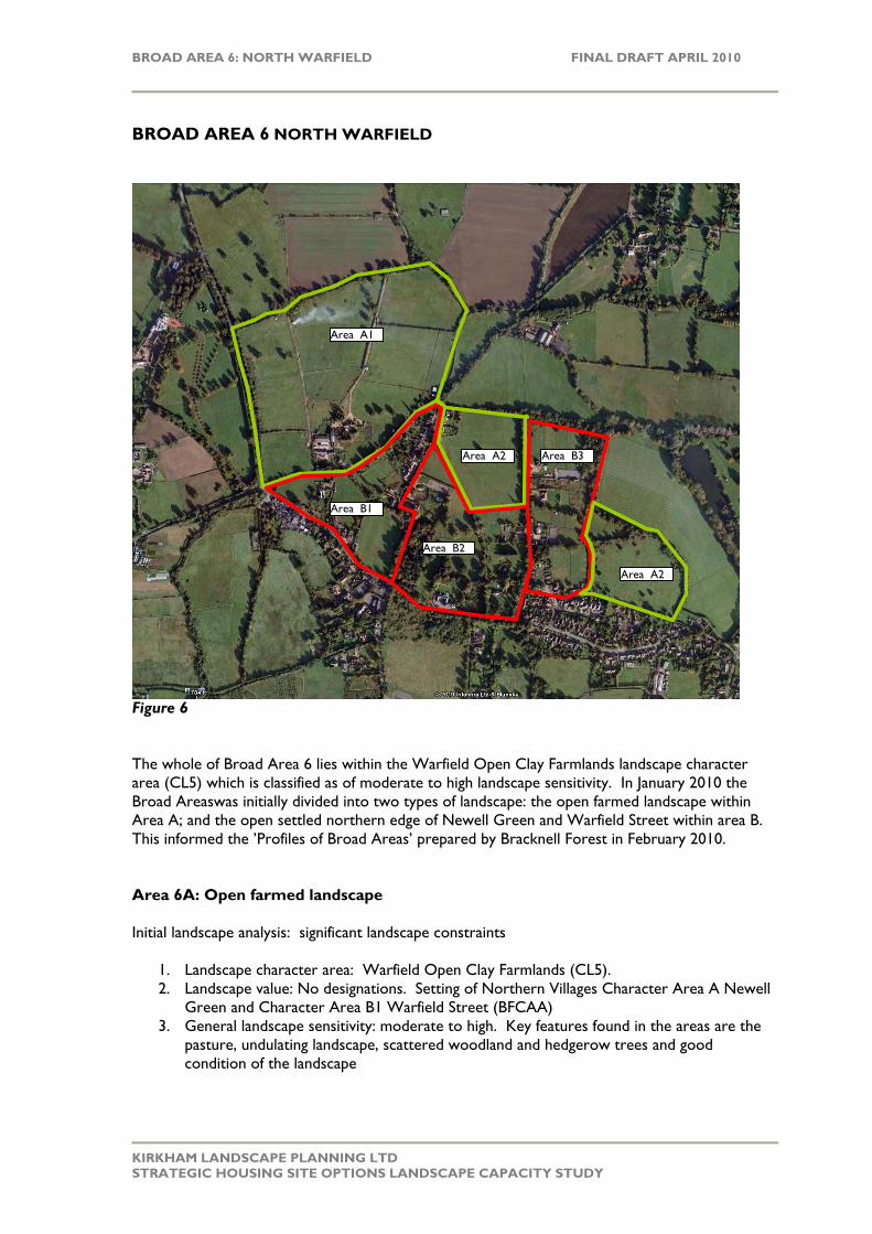
BROAD AREA 6: NORTH WARFIELD FINAL DRAFT APRIL 2010
BROAD AREA 6 NORTH WARFIELD
Area B3
Area B1
Area A2
Area A2
Area B2
Area A1
Figure 6
The whole of Broad Area 6 lies within the Warfield Open Clay Farmlands landscape character area (CL5) which is classified as of moderate to high landscape sensitivity. In January 2010 the Broad Areaswas initially divided into two types of landscape: the open farmed landscape within Area A; and the open settled northern edge of Newell Green and Warfield Street within area B. This informed the ’Profiles of Broad Areas’ prepared by Bracknell Forest in February 2010.
Area 6A: Open farmed landscape
Initial landscape analysis: significant landscape constraints
1. Landscape character area: Warfield Open Clay Farmlands (CL5).2. Landscape value: No designations. Setting of Northern Villages Character Area A Newell
Green and Character Area B1 Warfield Street (BFCAA)3. General landscape sensitivity: moderate to high. Key features found in the areas are the
pasture, undulating landscape, scattered woodland and hedgerow trees and goodcondition of the landscape
KIRKHAM LANDSCAPE PLANNING LTD STRATEGIC HOUSING SITE OPTIONS LANDSCAPE CAPACITY STUDY

BROAD AREA 6: NORTH WARFIELD FINAL DRAFT APRIL 2010
Area 6B: Open settled northern edge of Newell Green.
Initial landscape analysis: significant landscape constraints
1. Landscape character area: Warfield Open Clay Farmlands (CL5).2. Landscape value: No designations. Setting of Northern Villages Character Area B1
Warfield Street (BFCAA)3. General landscape sensitivity: moderate to high. Key features found in the areas are the
pasture, undulating landscape scattered woodland and hedgerow trees, clusteredsettlement and good condition of the landscape.
KIRKHAM LANDSCAPE PLANNING LTD STRATEGIC HOUSING SITE OPTIONS LANDSCAPE CAPACITY STUDY
BROAD AREA 6: NORTH WARFIELD FINAL DRAFT APRIL 2010
Detailed assessment
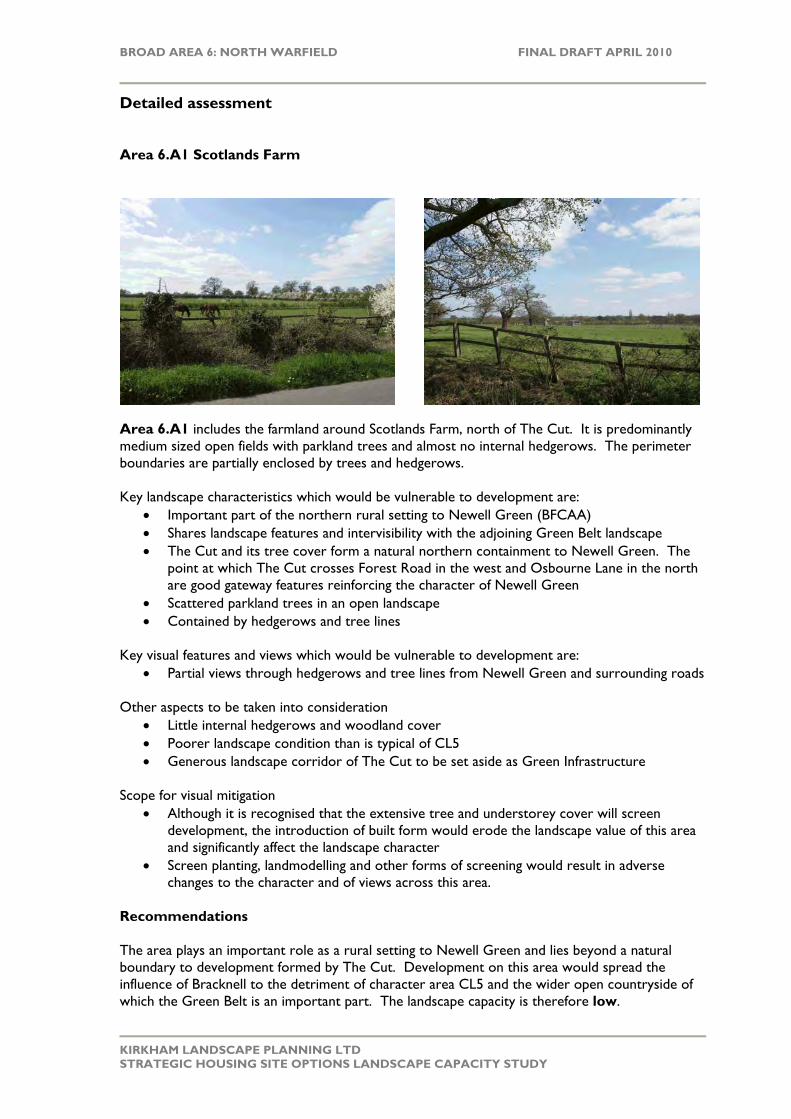
Area 6.A1 Scotlands Farm
Area 6.A1 includes the farmland around Scotlands Farm, north of The Cut. It is predominantly medium sized open fields with parkland trees and almost no internal hedgerows. The perimeter boundaries are partially enclosed by trees and hedgerows.
Key landscape characteristics which would be vulnerable to development are: • Important part of the northern rural setting to Newell Green (BFCAA)• Shares landscape features and intervisibility with the adjoining Green Belt landscape• The Cut and its tree cover form a natural northern containment to Newell Green. The
point at which The Cut crosses Forest Road in the west and Osbourne Lane in the northare good gateway features reinforcing the character of Newell Green
• Scattered parkland trees in an open landscape• Contained by hedgerows and tree lines
Key visual features and views which would be vulnerable to development are: • Partial views through hedgerows and tree lines from Newell Green and surrounding roads
Other aspects to be taken into consideration • Little internal hedgerows and woodland cover• Poorer landscape condition than is typical of CL5• Generous landscape corridor of The Cut to be set aside as Green Infrastructure
Scope for visual mitigation • Although it is recognised that the extensive tree and understorey cover will screen
development, the introduction of built form would erode the landscape value of this areaand significantly affect the landscape character
• Screen planting, landmodelling and other forms of screening would result in adversechanges to the character and of views across this area.
Recommendations
The area plays an important role as a rural setting to Newell Green and lies beyond a natural boundary to development formed by The Cut. Development on this area would spread the influence of Bracknell to the detriment of character area CL5 and the wider open countryside of which the Green Belt is an important part. The landscape capacity is therefore low.
KIRKHAM LANDSCAPE PLANNING LTD STRATEGIC HOUSING SITE OPTIONS LANDSCAPE CAPACITY STUDY

BROAD AREA 6: NORTH WARFIELD FINAL DRAFT APRIL 2010
Area 6:A2 Fields north of Warfield Street
Area 6.A2 includes two separate fields to the north of Warfield Street. Both are medium sized pasture enclosed by strong tree and hedgerows, abutting built form in the settlement.
Key landscape characteristics which would be vulnerable to development are: • Contribution to the northern rural setting of Warfield Street (BFCAA)• The Cut, the northern boundary of Magnolia House and the Bullbrook form a natural
northern containment to Warfield Street• Open pasture landscape in good condition• Well contained by hedgerows and tree lines
Key visual features and views which would be vulnerable to development are: • Views from Newhurst Gardens and Gibbins Lane
Other aspects to be taken into consideration • The areas do not lie beyond the natural containment boundaries to the village• Development should not erode the settlement pattern of the area (CL5)
Scope for visual mitigation • Screen views from Newhurst gardens• Views limited by hedgerows and tree lines and surrounding built form• Reinforcement of the site boundary planting
Recommendations
The features of Area 6:A2 are typical of CL5 but the area relates well to the existing settlement pattern. Localised visual impacts could be mitigated. The landscape capacity is therefore moderate.
KIRKHAM LANDSCAPE PLANNING LTD STRATEGIC HOUSING SITE OPTIONS LANDSCAPE CAPACITY STUDY

BROAD AREA 6: NORTH WARFIELD FINAL DRAFT APRIL 2010
Area 6:B1 Newell Green centre
Area 6.B1 is the core of Newell Green and has important landscape and open space elements which define the character of the village. These include the Memorial Ground, The Cut, the riparian intimate character of landscape next to The Cut, tree line along The Cut and its loose open character. The area also includes a small scale pattern of trees and short hedgerows and scattered dwellings.
Key landscape characteristics which would be vulnerable to development are: • Important village landscape and open space features of the village (BFCAA)• The rural character of The Cut and Osbourne Lane• Open varied and small scale landscape/ townscape in good condition• Internal trees and hedges• Riparian character of the northern part of the area
Key visual features and views which would be vulnerable to development • Many views out from the village to the surrounding countryside• Views of the tree lined Cut and local small riparian fields• Views form Forest Road and Osbourne Lane• Low lying but prominent area
Other aspects to be taken into consideration • This area relates well to the townscape core of Newell Green
Scope for visual mitigation of a very limited amount of development • Screen planting, landmodelling and other forms of screening would result in adverse
changes to the character and of views across this area• Maintain existing boundary treatment and vegetation pattern (BFCAA).
Recommendations
The site features of Area 6.A2 are typical of the settled parts of CL5 and the area plays an important part in forming the distinctive character of the village. However the area potentially has scope for some limited development in the west corner of this area, as long as it is in keeping with the character of the centre of this village (refer to BFCAA). The landscape capacity is therefore moderate to low, with a little scope for development in the west.
KIRKHAM LANDSCAPE PLANNING LTD STRATEGIC HOUSING SITE OPTIONS LANDSCAPE CAPACITY STUDY

BROAD AREA 6: NORTH WARFIELD FINAL DRAFT APRIL 2010
Area 6:B2: Newell Hall and its setting
Area 6.B2 includes Newell Hall and its grounds. These are mostly pasture in small fields and some ornamental grounds to the Hall and Cuckoo Cottage. There is good tree cover within the grounds which enclose the area, restricting views.
Key landscape characteristics which would be vulnerable to development are: • Dense tree cover• Small fields and lawns contained by hedgerows and ornamental planting
Key visual features and views which would be vulnerable to development are: • Visual separation of the two villages• Views from Warfield Street and Osbourne Lane
Other aspects to be taken into consideration • Strong landscape separation of Newell Green and Warfield Street provided by the area
(BFCAA)• Hall dates from 1700• Broad Areassettlement pattern of the area (CL5) may be eroded by merging Newell
Green and Warfield Street
Scope for visual mitigation of very limited amount of development • Retain tree cover close to Warfield Street and Osbourne Lane• Landmodelling and other forms of screening, other than planting, would result in adverse
changes to the character and of views across this area.
Recommendations
The site features are typical of the mix of woodland and parkland features found in CL5. The area is also important in retaining the separate character of Newell Green and Warfield Street. Provided the inherent landscape pattern and visual qualities are not lost, the area may be able accommodate a little low density development. The landscape capacity is therefore moderate to low.
KIRKHAM LANDSCAPE PLANNING LTD STRATEGIC HOUSING SITE OPTIONS LANDSCAPE CAPACITY STUDY

BROAD AREA 6: NORTH WARFIELD FINAL DRAFT APRIL 2010
Area 6.B3: Magnolia House and the caravan park
Area 6.B3 includes Magnolia House and its grounds, the caravan park to the south and the fields to the east. The area is already settled, with property separated by hedgerows. The northern and eastern boundaries are well defined by trees and the southern boundary is contiguous with existing properties in Warfield Street.
Key landscape characteristics which would be affected by development are: • Open pasture and transition landscape between dense settled area of Warfield Street and
the open countryside to the north• Remaining field pattern
Key visual features and views which would be affected by development are: • Views from Gibbins Lane between existing property to the wider landscape
Other aspects to be taken into consideration • The area relates well to the existing settlement pattern and is already partly developed• The transitional nature of the area should be reflected in the form of any development• Development should reinforce the settlement pattern of the area (CL5)
Scope for visual mitigation • Retain and reinforce boundary tree and hedgerows• Allow views through any development to the wider landscape.
Recommendations and reasons
The above shows that the site features are typical of the mix of loose settlement, small fields and tree and hedge cover found around the settlements in CL5. However the vegetation pattern could be retained as a structure for any development. It would be important to ensure a strong landscape buffer to the northern and eastern boundaries. The landscape capacity is therefore moderate to high.
KIRKHAM LANDSCAPE PLANNING LTD STRATEGIC HOUSING SITE OPTIONS LANDSCAPE CAPACITY STUDY

BROAD AREA 6: NORTH WARFIELD FINAL DRAFT APRIL 2010
Area Name Landscape capacity SHLAA site within area
Area A1 Scotlands Farm Low 128 Area A2 Fields north of Warfield Street Moderate 64 Area B1 Newell Green centre Low to moderate 9 Area B2 Newell Hall and its setting Low to moderate 92 Area B3 Magnolia House and the
caravan park Moderate to high 256 and 91
KIRKHAM LANDSCAPE PLANNING LTD STRATEGIC HOUSING SITE OPTIONS LANDSCAPE CAPACITY STUDY
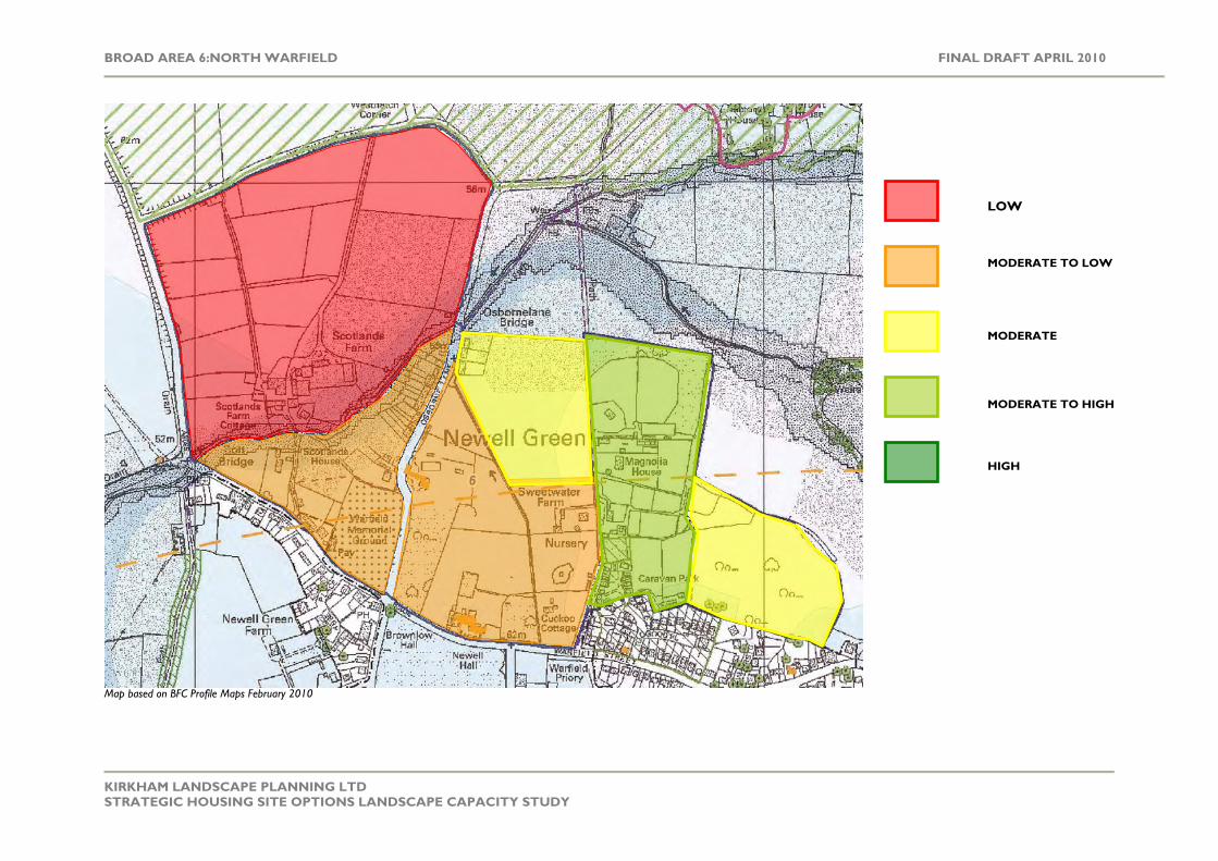
BROAD AREA 6:NORTH WARFIELD FINAL DRAFT APRIL 2010
HIGH
MODERATE TO HIGH
MODERATE
MODERATE TO LOW
LOW
KIRKHAM LANDSCAPE PLANNING LTD STRATEGIC HOUSING SITE OPTIONS LANDSCAPE CAPACITY STUDY
Map based on BFC Profile Maps February 2010

Local Landscape Appraisal: Hayley Green, Newell Green & Warfield Street.
1077 Fig 6; Warfield Supplementary Planning Document (Feb 2012)

1.5 The production of this document has been influenced by evidence, appraisal, prospective developers,consultation responses, resident groups and Warfield Parish Council. The area covered by the Warfield SPD can be seen in Figure 1 'Extent of Warfield SPD area'
Figure 1 Extent of Warfield SPD area
The Purpose of the Warfield SPD:
1.6 The purpose of the Warfield SPD is to:
Guide the implementation of Policy CS5 (Land North of Whitegrove and Quelm Park (parish of Warfield)) in the adopted Bracknell Forest Core Strategy Development Plan Document (DPD) and/or any relevant policy in the emerging Site Allocations DPD. Provide a starting point for preparing future detailed masterplanning/planning applications for this area. Help determine planning applications.
Supporting Documentation
1.7 All supporting documentation relating to the Warfield SPD has been published either online at www.bracknell-forest.gov.uk/warfield or made available on request. Each document is given a unique reference, for example, the Warfield SPD is referenced as WL35. These are:
www.bracknell-forest.gov.uk/warfield 2

Local Landscape Appraisal: Hayley Green, Newell Green & Warfield Street.
1077 Fig 7; Site Allocations Local Plan 2013
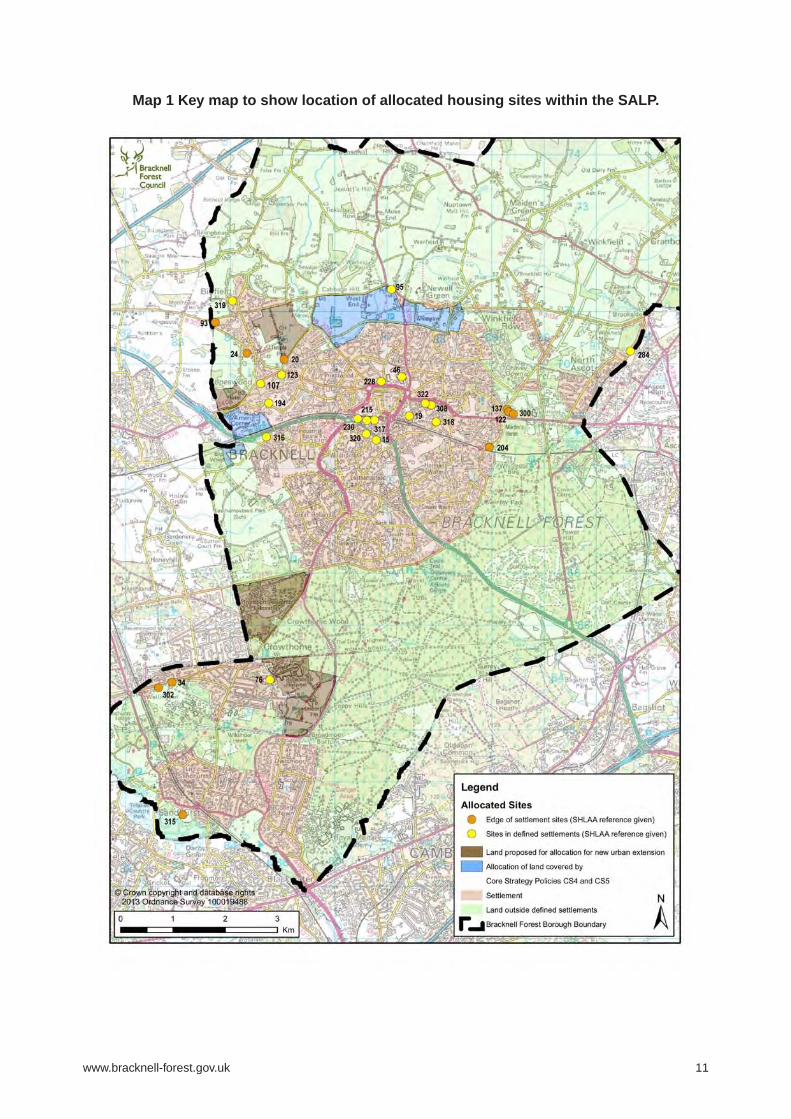
Map 1 Key map to show location of allocated housing sites within the SALP.
www.bracknell-forest.gov.uk 11
Local Landscape Appraisal: Hayley Green, Newell Green & Warfield Street.
1077 Fig 8; LUC Character Assessment and Review of ENTEC Gaps/Green Wedges Policy
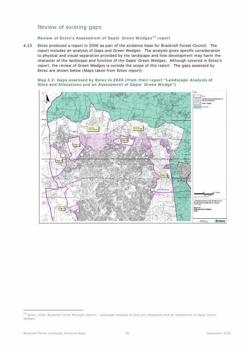
Bracknell Forest Landscape Evidence Base 49 September 2015
Review of existing gaps
Review of Entec’s Assessment of Gaps/ Green Wedges15 report
Entec produced a report in 2006 as part of the evidence base for Bracknell Forest Council. The 4.13report includes an analysis of Gaps and Green Wedges. The analysis gives specific consideration to physical and visual separation provided by the landscape and how development may harm the character of the landscape and function of the Gaps/ Green Wedges. Although covered in Entec’s report, the review of Green Wedges is outside the scope of this report. The gaps assessed by Entec are shown below (Maps taken from Entec report):
Map 4.2: Gaps assessed by Entec in 2006 (from their report “Landscape Analysis of Sites and Allocations and an Assessment of Gaps/ Green Wedge”)
15 Entec, 2006: Bracknell Forest Borough Council – Landscape Analysis of Sites and Allocations and an Assessment of Gaps/ GreenWedges.

Local Landscape Appraisal: Hayley Green, Newell Green & Warfield Street.
1077 Fig 9; Strategic Housing and Economic Land Availability Assessment (SHELAA)
Map of Warfield Sites v2 (Nov 2016)

! ! ! ! ! ! ! ! ! !
! ! ! ! ! ! ! ! ! !
! ! ! ! ! ! ! ! ! !
! ! ! ! ! ! ! ! ! !
! ! ! ! ! ! ! ! ! !
! ! ! ! ! ! ! ! ! !
! ! ! ! ! ! ! ! ! !
! ! ! ! ! ! ! ! ! !
! ! ! ! ! ! ! ! ! !
! ! ! ! ! ! ! ! ! !
! ! ! ! ! ! ! ! ! !
! ! ! ! ! ! !
! ! ! ! ! ! !
! ! ! ! ! ! !
! ! ! ! ! ! !
! ! ! ! ! ! !
! ! ! ! ! ! !
! ! ! ! ! ! !
! ! ! ! ! ! !
! ! ! ! ! ! !
! ! ! ! ! ! !
! ! ! ! ! ! !
! ! ! ! ! ! !
! ! ! ! ! ! !
! ! ! ! ! ! ! !
! ! ! ! ! ! ! !
! ! ! ! ! ! ! !
! ! ! ! ! ! ! !
! ! ! ! ! ! ! !! ! ! ! ! ! ! !
! ! ! ! ! ! ! !
! ! ! ! ! ! ! !
! ! ! ! ! ! ! !
! ! ! ! ! ! ! !
! ! ! ! ! ! ! !
! ! ! ! ! ! ! !
! ! ! ! ! ! ! !
Binfield With Warfield
Winkfield And Cranbourne
Bullbrook Ascot
Priestwood And Garth
Warfield Harvest Ride
Wildridings And Central
Harmans WaterGreat Hollands North
Harmans Water
Warfield Parish
Bracknell Town
Binfield Parish
Winkfield Parish
War13War10 War16War12
War15
Wink16
War18War19
Wink21
Wink15
Wink17
War4
War9
Bra6
Bra7
Wink18
Wink7
Wink19
Wink1
War11
War7
War14
Bra11
Bra8
War8
Bra5
War17
Bra9Bra10
War3
War3
War3
War3
War3War3
War3
War6
War5
Wink20
Wink220 0.2 0.4 0.6 0.8 1
Kilometres
Crown Copyright and database rights 2016 Ordnance Survey LA100019488.
Warfield SHELAASites Nov 2016 V2
LegendSHELAA Sites
Sites < 1haSites 1ha - 2haSites 2ha - 10ha
! ! ! !
! ! ! ! Sites 10ha - 50haSites > 50ha
Settlement BoundariesWard BoundariesParish BoundariesBFC Borough BoundaryGreen Belt
±
Local Landscape Appraisal: Hayley Green, Newell Green & Warfield Street.
1077 Fig 10; Warfield Neighbourhood Plan: Policy Map Updated to include Pre-Submission version


Local Landscape Appraisal: Hayley Green, Newell Green & Warfield Street.
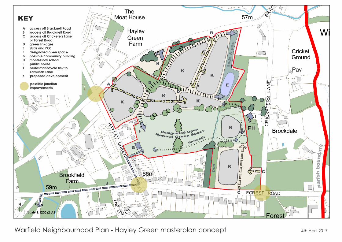
1077 Fig 11; Warfield Neighbourhood Plan: Hayley Green MasterplanUpdated to include Pre-Submission version