101608 USGR Steering Committee Minutes
137
1 Draft Minutes Upper San Gabriel River and Rio Hondo Sub-Region Joint Meeting of the Steering Committee and San Gabriel Valley COG October 16, 2008 – 1:30 pm – 3:30 pm San Gabriel Basin Water Quality Authority 1720 West Cameron Avenue, Suite 100, West Covina, CA 91790 1. Introductions Grace Kast opened the meeting with introductions. Attendees: Michael Antos MaryAnn Lutz Shirley Birosik Holly Merrinew Bae Changmii Jorge Morales Bekah Cooke Katie Morris Marisa Creter Peter Rodriguez Ann Croissant Bertha Ruiz-Hoffman Cindy DeChaine Randy Schoellerman George De La O Sarina Sriboonlue Robert Gomez Craig Stehsel Andree Hunt Tom Tait Grace Kast Carol Williams Frank Kuo Tim Worley Wendy La Tony Zampiello Ed Means Mary Zauner 2. Approve September 18, 2008 Meeting Minutes The meeting minutes were approved unanimously with one change. The sub- regional workshop minutes were approved unanimously with three changes. 3. Prioritization Framework Ed Means gave a presentation on the prioritization framework. The presentation is attached. Discussion included: • Governor’s signing of SBX21 indicates that Prop 84 money with become available in an April timeframe. • The IRWMP prioritization process sought to evaluate projects based on their multiple benefits. When grants become available, there may be narrow grants for single benefit projects where rankings aren’t applicable. • The rankings demonstrate the importance of multiple benefits projects, which the State favors. • Projects that aren’t in the database need to be added, because only projects in the IRWMP will be eligible for funding. Persons who enter
Transcript of 101608 USGR Steering Committee Minutes

1
Draft Minutes Upper San Gabriel River and Rio Hondo Sub-Region
Joint Meeting of the Steering Committee and San Gabriel Valley COG
October 16, 2008 – 1:30 pm – 3:30 pm San Gabriel Basin Water Quality Authority
1720 West Cameron Avenue, Suite 100, West Covina, CA 91790
1. Introductions Grace Kast opened the meeting with introductions. Attendees: Michael Antos MaryAnn Lutz Shirley Birosik Holly Merrinew Bae Changmii Jorge Morales Bekah Cooke Katie Morris Marisa Creter Peter Rodriguez Ann Croissant Bertha Ruiz-Hoffman Cindy DeChaine Randy Schoellerman George De La O Sarina Sriboonlue Robert Gomez Craig Stehsel Andree Hunt Tom Tait Grace Kast Carol Williams Frank Kuo Tim Worley Wendy La Tony Zampiello Ed Means Mary Zauner 2. Approve September 18, 2008 Meeting Minutes The meeting minutes were approved unanimously with one change. The sub-regional workshop minutes were approved unanimously with three changes. 3. Prioritization Framework Ed Means gave a presentation on the prioritization framework. The presentation is attached. Discussion included:
• Governor’s signing of SBX21 indicates that Prop 84 money with become available in an April timeframe.
• The IRWMP prioritization process sought to evaluate projects based on their multiple benefits. When grants become available, there may be narrow grants for single benefit projects where rankings aren’t applicable.
• The rankings demonstrate the importance of multiple benefits projects, which the State favors.
• Projects that aren’t in the database need to be added, because only projects in the IRWMP will be eligible for funding. Persons who enter

DAC-1DAC-2
Notes ProjectId ProjectTitle AgencyPartneringAgency
DAC-1 - might not be in a DAC 172
Watershed U. - Rio Hondo
UC Cooperative Extension
DAC-1- need to speak with Anne Croissant; could be a duplicate 180
Watershed U.- San Gabriel
UC Cooperative Extension
Move to Lower SG 204
Cudahy River Drive Beautification City of Cudahy
DAC-2 208Santa Anita Dam Seismic Rehabilitation
Los Angeles County Flood Control District
City of Arcadia City of Sierra Madre
209
Santa Anita Debris Dam Seismic Rehabilitation
Los Angeles County Flood Control District
City of Arcadia City of Sierra Madre
Not in a DAC census tract area but includes water supply benefit to DACsDirect benefit to DAC and located in a DAC census tract

DAC 238
Peck Lake Wetlands Enhancement and Recharge
Los Angeles County Flood Control District
Robert Gomez will delete 239
Peck Park Sub-Regional Trash Solution
Los Angeles County Flood Control District
Robert Gomez will delete 249
Trash Removal Subregional Solution - Upper Rio Hondo
Los Angeles County Flood Control District
DAC-2 270San Gabriel Dam Spillway Dam
Los Angeles County Flood Control District
DAC-2 271Cogswell Dam Spillway Dam
Los Angeles County Flood Control District
635Additional Interconnections
City of Sierra Madre & other water systems
DAC-1? - Check with Claire 636
Alhambra Wash Naturalization Implementation
Amigos de los Rios/Rivers and Mountains Conservancy
County of Los Angeles Department Of Parks & Recreation
DAC-1? - Check with Claire 637
Alhambra Wash Naturalization II
Amigos de los Rios, RMC

DAC-2 638 Alosta Connection
Water purveyors in the Raymond & Main San Gabriel Basin
Three Valleys MWD, Metropolitan Water District
Inactive - Dan to delete 639
Amarillo Mutual Water Company VOC Treatment Plant
San Gabriel Basin Water Quality Authority
Inactive - complete 644
Arrow Hwy Trail Connection
Los Angeles County Flood Control District
Inactive 645 Arroyo Rosa Castilla
County of Los Angeles Department of Public Works

DAC-1 648Azusa Bike Trail Network City of Azusa
649Azusa Canyon River Wilderness Park
Watershed Conservation Authority
Rivers and Moutains Conservancy, ACOE, DFG
Inactive - DAC-1 652 Barnes Park Baldwin Park
Inactive - DAC-1 653Barranca Park Renovation Project City of Covina, RMC
Inactive 654Barrel Springs Road Staging Area City of Palmdale
DAC-2 656
Big Dalton Spreading Grounds Improvements
Los Angeles County Flood Control District
Ask Claire Robinson to put in contact info 657
Bike Connection- Peck Park/San Gabriel River
Amigos de los Rios, RMC
Add Anne Croissant as contact 658
Black Fly Vector Research SGMRC
Inactive 660 Bonelli Trail Bridge
County of Los Angeles Dept of Pks and Rec, RMC
Inactive 663 Bubalo QuarryHanson Aggregate West

Combine with 5434 664
Buena Vista Bio Engineered Wetlands
Los Angeles County Flood Control District, RMC
Inactive completed 665
California Domestic Water Company Well No 14
San Gabriel Basin Water Quality Authority
N/A 666Caltrans Right-of-Way Open Space & Tril Baldwin Park, Caltrans
DAC-2 667Capture of Additional Storm Runoff
Raymond Basin Management Board
DAC -1 669
Charter Oak Wash Open Channel & Streambed Betterments within Kahler Russel City of Covina
DAC-2 671CIC Surface and GW Treatment Project
TVMWD, USGVMWD, Covina Irrigating Co.
DAC-2 672
Citrus and Ben Lomand Spreading Grounds Interconnecting Pipeline
Los Angeles County Flood Control District
DAC-2 673
Citrus Spreading Grounds Telemetry Improvements, Landscaping Improvements a
Los Angeles County Flood Control District
Inactive completed 674
City of Alhambra Phase II VOC Treatment Plant
San Gabriel Basin Water Quality Authority

Inactive completed 675
City of Monrovia VOC Treatment Plant
San Gabriel Basin Water Quality Authority
Inactive 676City of Monterey Park Fern Well
San Gabriel Basin Water Quality Authority
Inactive-completed 677
City of Monterey Park Well 12 and 15 Treatment Facility
San Gabriel Basin Water Quality Authority
Duplicate with one below 678
City of Monterey Park Well 5 & Well 6 VOC Expansion & Perchlorate Treatment
San Gabriel Basin Water Quality Authority
DAC-1 678
City of Monterey Park Well 5 & Well 6 VOC Expansion & Perchlorate Treatment
San Gabriel Basin Water Quality Authority
Duplicate with one below 678
City of Monterey Park Well 5 & Well 6 VOC Expansion & Perchlorate Treatment
San Gabriel Basin Water Quality Authority
Duplicate with one below 678
City of Monterey Park Well 5 & Well 6 VOC Expansion & Perchlorate Treatment
San Gabriel Basin Water Quality Authority
Inactive-completed 679
City of Monterey Park Wells Nos. 1, 3 and 10 Treatment Facility
San Gabriel Basin Water Quality Authority
Inactive 683Community Recreation Facility Temple City, RMC
DAC-1 684Conjunctive Use for the Puente Basin
Walnut Valley W.D., Rowland W.D., TVMWD, Metropolitan
Inactive-completed 685
Containment of Contamination at Lincoln Ave. Water Co.
LAWC, City of Pasadena, Raymond Basin Management Board

Inactive - scott delinger 686 Copper Toxicity Model
Gateways Cities COG, RMC
Inactive 687
Covina Civic Center Park Open Space Element City of Covina, RMC
688
Covina Irrigating Co. Surface Water Treatment Plant Improvements
Upper San Gabriel Valley Municipal Water District
690
Develop Wellfield/Pipeline outside the APH
Producers pumping from the APH
Inactive 691Duarte Bike Trail Extension City of Duarte

692
Duck Farm Geotechnical Studies Phase II
Mountains Rec and Cons. Authority, RMC
Inactive - delete; Anne Croissant 695
Early Tongva Site Land Acquisition
SGMRC & Glendora Conservancy, RMCCounty parks to
add Jim Smith - Jim to send Frank an email, may not be in USGR; move to 697
East Los Angeles Civic Center Improvements County of Los Angeles
Tony Zampiello to check against 209 698
East Raymond Basin Water Resource Plan/Program
Cities of Arcadia and Sierra Madre, RMC
699
East San Gabriel Valley Regional Distribution System
Cities of Industry and Covina
DAC-1 700
East Side Performing Settling Defendants and City of El Monte East Side Dee
San Gabriel Basin Water Quality Authority
DAC-1 701
East Side Performing Settling Defendants East Side Shallow Remedy
San Gabriel Basin Water Quality Authority
DAC-2 702
Eaton Spreading Grounds Intake Improvements
Los Angeles County Flood Control District
Jim Smith to contact Amigos 703
Eaton Wash Nature Park
Amigo de Los Rios, RMC

Inactive completed 705 El Encanto
Watershed Conservation Authority, RMC
Inactive 706El Monte Multi-Use Trail Master Plan City of El Monte, RMC
DAC-1 707
El Monte Storm Drain Daylighting/Green Infrastructure
Amigos de los Rios/City of El Monte
City of El Monte, Valley Mall Businesses, Emerald Necklace Business Alliance,
DAC-1 708
Emerald Necklace Segment A:Alhambra Wash to Eaton Wash
San Gabriel & Lower Los Angeles Rivers & Mountains Conservancy, Amigos de L
DAC-1 709
Emerald Necklace Segment B:Eaton Wash to S. Edge of Peck Pk
San Gabriel & Lower Los Angeles Rivers & Mountains Conservancy, Amigos de L
DAC-1 710
Emerald Necklace Segment C: Peck Rd Water Conserv. Pk to SGR
San Gabriel & Lower Los Angeles Rivers & Mountains Conservancy, Amigos de L
DAC-1 711
Emerald Necklace Segment D:San Gabriel River to Walnut Creek
San Gabriel & Lower Los Angeles Rivers & Mountains Conservancy, Amigos de L

Tony Zampiello to check 712
Emergency Interconnections NA
DAC-1 713
Enhancement of Canyon Collection System
RUBIO CANON LAND AND WATER ASSOC.
Inactive - Anne Croissant to check 714
Environmental Discovery Center SGMRC, RMC
Inactive - Anne Croissant to check 715
Environmental Quality Assessment Projects SGMRC, RMC
Inactive - Anne Croissant to check 716
Evaluation of stream periphyton & its relationship to beneficial uses SCCWRP, RMC
Inactive 717
Evaluation of watershed nutrient levels under a range of conditions using w SCCWRP, RMC
Inactive 720Flint Wash Bridge Crossing Restoration City of Pasadena
Inactive 721Float Tubing & Fishing Study FFCOC
Inactive 722Floating Islands at Spreading Facilities Watermaster

723
Foothill Basin Conjunctive Use Project
TVMWD, MWD, & Golden State Water Co.
Inactive 724Forest Master Plan Update USFS
726Fulton Plant GW Treatment Project
TVMWD, Walnut Valley W.D., Rowland W.D.
Inactive - move to LLA/SG 728 Gage Pocket Park
County of Los Angeles Department of Public Works
DAC-1 729 Galster Park ProjectCity of West Covina, RMC
DAC-1 730
Ganesha GW Treatment Plant System
City of Pomona, TVMWD
Inactive - DAC-1 731Gibson Park Habitat Plantings
City of El Monte and Amigos de los Rios, RMC
Inactive - DAC-1 732
Gidley Elementary School Greening and Passive Recreation Enhancement
City of El Monte and Amigos de los Rios, RMC
733
Glendora Basin Conjunctive Use Project
TVMWD, City of Glendora, & Main San Gabriel Basin Watermaster
Inactive completed 736
Golden State Water Company Encinita VOC Treatment Plant
San Gabriel Basin Water Quality Authority
Grace Kast to check contaminant - change to NO3 737
Golden State Water Company Wells SG1 and SG2 Perchlorate Treatment Facility
San Gabriel Basin Water Quality Authority

Inactive - completed 738
Golden State Water Company Wells SG1 and SG2 VOC Treatment Facility
San Gabriel Basin Water Quality Authority
Anne Croissant to adopt - check with Tim Jochem re: project 853 740
Gravel Pits Reclamation/Study
UP_SG_RVR MWD, RMC, Sierra Club, RMC
Inactive 742 Green Visions Phase IIWatershed Conservation Authority
Inactive 745Habitat Authority Community Outreach
CA Native Habitat Endowment Fund, RMC
Inactive 746Habitat Passage Around Santa Fe Dam TBD
Double check with Tim - Tony Zampiello 747 Hanson Pit
Main San Gabriel Basin Producers
Inactive 748 Hanson Quarry
City of Irwindale, Hanson Aggregate West
Inactive 749Heritage Garden Project
City of West Covina, RMC
DAC-1 750Hermetic Seal Site Extraction
San Gabriel Basin Water Quality Authority

751Hilda Solis Park Native Habitat Beautification
Amigos de los Rios & City of Baldwin Park, RMC
Inactive completed 753
Historical Ecology of the RMC Territory
So CA Coastal Water Research Project
Inactive 755
Hollydale Regional Park Community Center/Gymnasium City of South Gate
Inactive 756Horseman's Park Restoration
Friends of the S. G. River, RMC
Inactive 757Horsethief Cyn Park Master Plan
City of San Dimas, RMC
Inactive 758
Hwy 39/San Gabriel River Recreation Needs Assessment
USFS, Caltrans, SGMRC

DAC-2 759
Increase Cooperative Water Exchange Agreement (CWEA) deliveries through USG
City of Alhambra, Metropolitan, SGVMWD
760Indian Hill Well Development
Golden State Water Co., TVMWD
Inactive 761Integrated Regional Water Management
Watershed Conservation Authority
762
Invasive Plant Control in Riparian Habitat of Los Angeles Basin
LASGR Watershed Council
Inactive - Complete 763
Irwindale Spreading Grounds and Manning Pit - Interconnecting Drain and Bas
Los Angeles County Flood Control District
Inactive complete 765Johnson's Pasture Acquisition RMC
Claremont Wildland Conservancy, City of Clarement
Inactive complete 768
La Puente Valley County Water District Demonstration Project
San Gabriel Basin Water Quality Authority

DAC-2 771
LACDA Project - Stormwater Management Plan
Los Angeles County Flood Control District
Inactive 773Langford Watershed Park
County of Los Angeles Department of Public Works
DAC-1 774
Lario Creek Stream Corridor Restoration Plan (Lario Creek/Zone 1 Ditch)
North East Trees/Los Angeles County Flood Control District, RMC
Inactive- completed 776
Legg Lake Fishing Pier
County of Los Angeles Department of Parks and Recreation
779
Live Oak Spreading Grounds Intake Improvements
Los Angeles County Flood Control District
Inactive 780
Long Term Mgt Plan: West Fork San Gabriel River
West Fork Working Group
Inactive 781
Main San Gabriel Basin Groundwater Cleanup USGVMWD
Inactive 787Marshall Cnyn. Cons. Cor. Phase II 1
SGMRC and Cnty of L.A. Pks and Rec, RMC
Inactive 792Maverick / Ridgeline Rider Project
City of West Covina, RMC

Inactive 793 Metrolink Station Trail City of El Monte, RMC
Inactive 794Mission Creek Restoration Project
Whittier Narrows Nature Center
Inactive 800Monrovia Foothills-Kissinger Property City of Monrovia, RMC
DAC-1 810Montebello Hills Open Space
Rivers and Mountains Conservancy
City of Montebello, Los Angeles County Dept of Park and Rec, Sierra Club
812Morris Dam Peninsula Park
Los Angeles County Flood Control District, RMC
Inactive-funded Prop 50 813
Morris Dam Water Supply Enhancement Project
Los Angeles County Flood Control District
Inactive 816Naturalize Storm Channels Concept Watermaster
817New Interconnection with City of Alhambra City of Monterey Park
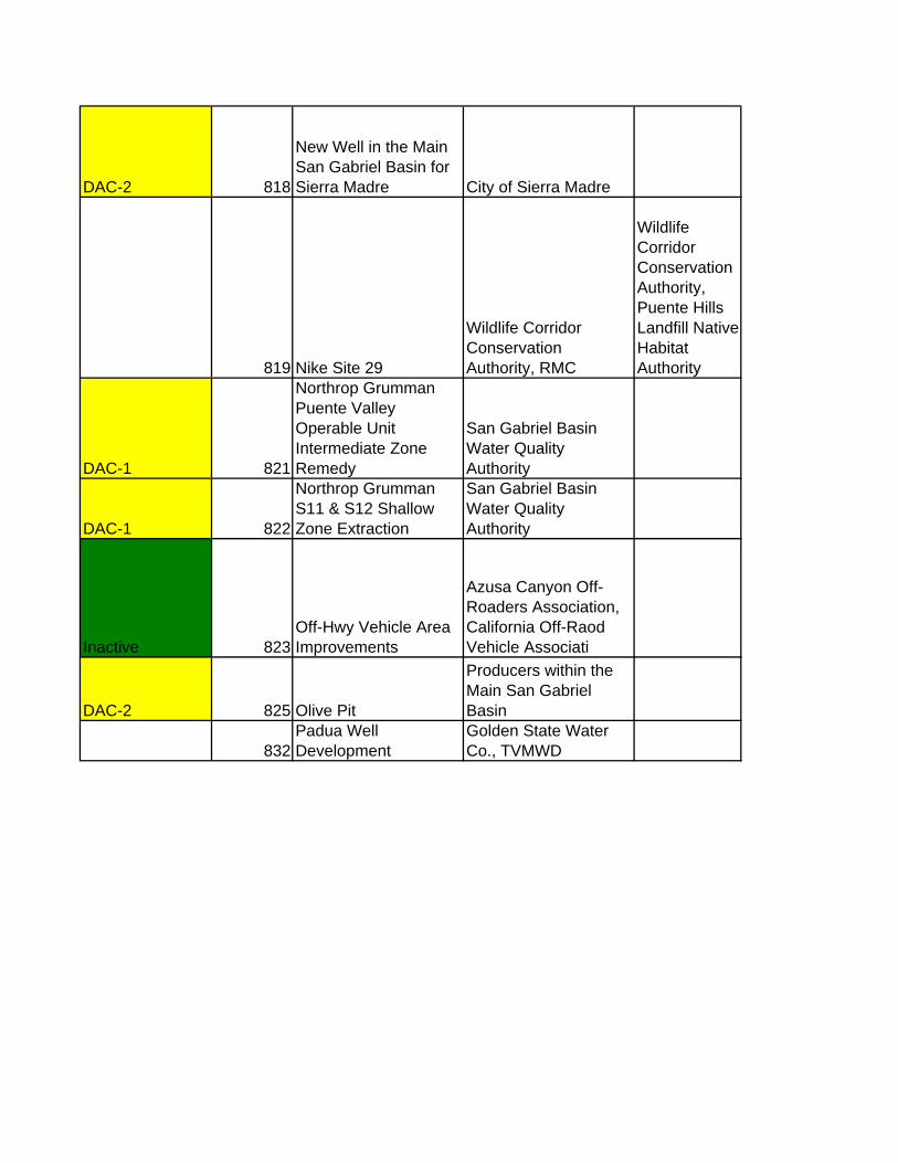
DAC-2 818
New Well in the Main San Gabriel Basin for Sierra Madre City of Sierra Madre
819 Nike Site 29
Wildlife Corridor Conservation Authority, RMC
Wildlife Corridor Conservation Authority, Puente Hills Landfill Native Habitat Authority
DAC-1 821
Northrop Grumman Puente Valley Operable Unit Intermediate Zone Remedy
San Gabriel Basin Water Quality Authority
DAC-1 822
Northrop Grumman S11 & S12 Shallow Zone Extraction
San Gabriel Basin Water Quality Authority
Inactive 823Off-Hwy Vehicle Area Improvements
Azusa Canyon Off-Roaders Association, California Off-Raod Vehicle Associati
DAC-2 825 Olive Pit
Producers within the Main San Gabriel Basin
832Padua Well Development
Golden State Water Co., TVMWD

DAC-1 837
Peck Water Conservation Park Implementation Amigos de los Rios
Los Angeles County Public Works, Recreation and Parks, City of El Monte, Rivers and Mountains Conservancy
838
Peck Park Nature Habitat Demonstration Garden
Amigo de Los Rios, RMC
DAC-1 840
Peck Water Conservation Park - Design Development & Construction Plans Amigos de los Rios
Los Angeles County Department of Parks and Recreation; Los Angeles DWP Watershed Management Division; City of Arcadia; City of El Monte; California Department of Fish & Game
841Pedley Spreading Grounds
City of Pomona, TVMWD
842
Pedley Water Treatment Plant Upgrade
City of Pomona, TVMWD

847 Puddingstone WetlandLos Angeles County Flood Control District
849
Puente Hills and Whittier Narrows Habitat Connection
Puente Hills Landfill Native Habitat Preservation Authority
850Puente Hills Wildlife Corridor
Puente Hills Landfill Native Habitat Preservation Authority
Inactive - Jim Smith to adopt? 852
Puente-Chino Hills Gap Analysis Sierra Club, RMC
Anne Croissant / Tim Jochem talk re: project 740 853
Quarry Reclamation/Water Storage/Recreational Facilities Development Study
USGVMWD, RMC, Sierra Club
Inactive 854 Ramona Blvd GatewayEl Monte, Baldwin Park
Inactive 860
Implementtation of Rio Hondo Watershed Plan
San Gabriel Valley Council of Governments, RMC
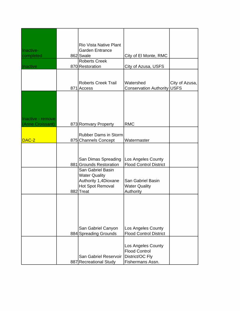
Inactive- completed 862
Rio Vista Native Plant Garden Entrance Swale City of El Monte, RMC
Inactive 870Roberts Creek Restoration City of Azusa, USFS
871Roberts Creek Trail Access
Watershed Conservation Authority
City of Azusa, USFS
Inactive - remove (Anne Croissant) 873 Romvary Property RMC
DAC-2 875Rubber Dams in Storm Channels Concept Watermaster
881San Dimas Spreading Grounds Restoration
Los Angeles County Flood Control District
882
San Gabriel Basin Water Quality Authority 1,4Dioxane Hot Spot Removal Treat
San Gabriel Basin Water Quality Authority
884San Gabriel Canyon Spreading Grounds
Los Angeles County Flood Control District
887San Gabriel Reservoir Recreational Study
Los Angeles County Flood Control District/OC Fly Fishermans Assn.

Inactive 889
San Gabriel River Beautification & Environmental Enhancement
HBT, City of Irwindale, WCA, LADPR, ACE
890San Gabriel River Bike Trail Bridge
Los Angeles County Flood Control District
Inactive 891
San Gabriel River Bike Trail Extension to Azusa River Wilderness Park City of Azusa, RMC
DAC-1 897
San Gabriel Valley Water Company Plant 8 1,4-Dioxane and Perchlorate Treatm
San Gabriel Basin Water Quality Authority
DAC-1 898
San Gabriel Valley Water Company Plant 8 VOC Treatment
San Gabriel Basin Water Quality Authority
Inactive - completed 899
San Gabriel Valley Water Company Plant B5
San Gabriel Basin Water Quality Authority
inactive completed 900
San Gabriel Valley Water Company Plant B6
San Gabriel Basin Water Quality Authority
DAC-1 901
San Gabriel Valley Water Company Plant B7
San Gabriel Basin Water Quality Authority
DAC-1 902
San Gabriel Valley Water Company Plant G4
San Gabriel Basin Water Quality Authority
904San Jose Creek Bike Trail Bridge
Los Angeles County Flood Control District
905San Jose Creek Bike Trail Phase III
Los Angeles County Flood Control District

Inactive 908San Jose Creek Greenway Project
Amigo de Los Rios, RMC
Inactive 909San Jose Creek Habitat Restoration
North East Trees, RMC
DAC-2 910
San Jose Creek Spreading Grounds Feasibility Study
Los Angeles County Flood Control District
DAC-2 Robert Gomez to revise/update 911
San Jose Creek TMDL Project Concept
Los Angeles County Flood Control District
DAC-2 916Santa Anita Reservoir Sediment Removal
Los Angeles County Flood Control District
DAC-2 917
Santa Anita Spreading Grounds Improvements
Los Angeles County Flood Control District
Inactive - Jim Smith to adopt ? Anne Croissant to be added as partnering agency 919
Santa Fe Dam Recreation Area & Habitat Enhancements LADPR
Inactive 920
Santa Fe Storm Water Storage Project: Divert Storm Water to San Gabriel Riv
Main San Gabriel Basin Producers

923
Sediment Management Plan (Cogswell Reservoir)
Los Angeles County Flood Control District
924
Sediment Management Plan (San Gabriel Canyon)
Los Angeles County Flood Control District
DAC-2 926
Simpson Well Assessment & Rehabilitation
City of Pomona, TVMWD
DAC-2 927
Six Basins & Chino Basin Conjunctive Use Program Enhancement
TVMWD, Inland Empire Utiltities Agency, Six Basins Watermaster, Chino Basin
Inactive 928
Small Recycled Water Systems at Schools & Shopping Centers Watermaster
DAC-2 932
Spread Water at Eaton Basin through injection Wells
Raymond Basin Producers, Raymond Basin Management Board
DAC? 935
Suburban Water Systems Wells 121 & 142
San Gabriel Basin Water Quality Authority
Inactive 936Surface Water Treatment Plants USGVMWD
Inactive 941Synthetic Turf Athletic Fields USGVMWD
Inactive - complete 943 Thienes Gateway
City of So. El Monte, HBT, Friends of the San Gabriel River, LAOSD

Robert Gomez to update 950
Traffic Flow Improvements around Santa Fe Dam Recreation Area
Los Angeles County Flood Control District
Inactive 951
Trail Connection - Alhambra Wash - Rosemead Community Center
Amigo de Los Rios, RMC
955Treatment Plant Projects for Arsenic City of Monterey Park
Inactive 956United Rock Products Quarry #1
Irwindale, United Rock Products
Inactive 957United Rock Products Quarry #2
Irwindale, United Rock Products
Inactive 958United Rock Products Quarry #3
Irwindale, United Rock Products
Complete? 959
United Technologies Corporation Puente Valley Operable Unit Shallow Zone Re
San Gabriel Basin Water Quality Authority
Inactive 962
Use of Parks as Groundwater Recharge Facilities NA
inactive 963
Use of Pervious Material for Roads Concept Watermaster
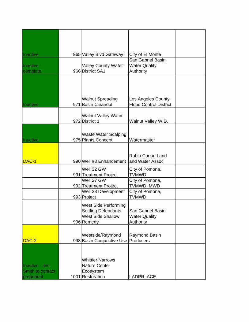
Inactive 965 Valley Blvd Gateway City of El Monte
Inactive - complete 966
Valley County Water District SA1
San Gabriel Basin Water Quality Authority
Inactive 971Walnut Spreading Basin Cleanout
Los Angeles County Flood Control District
972Walnut Valley Water District 1 Walnut Valley W.D.
Inactive 975Waste Water Scalping Plants Concept Watermaster
DAC-1 990 Well #3 EnhancementRubio Canon Land and Water Assoc
991Well 32 GW Treatment Project
City of Pomona, TVMWD
992Well 37 GW Treatment Project
City of Pomona, TVMWD, MWD
993Well 38 Development Project
City of Pomona, TVMWD
996
West Side Performing Settling Defendants West Side Shallow Remedy
San Gabriel Basin Water Quality Authority
DAC-2 998Westside/Raymond Basin Conjunctive Use
Raymond Basin Producers
Inactive - Jim Smith to contact proponent 1001
Whittier Narrows Nature Center Ecosystem Restoration LADPR, ACE

Inactive complete 1003Whittier Narrows Recreation Area USGVMWD
Inactive 1004Whittier Narrows Wildlife Lakes
LADPR, Water Replenishment District
Inactive 1005 Wildwood Canyon
City of Glendora, Glenoora Community Conservancy, RMC
1008
Zanjero Park at San Gabriel Canyon Spreading Grounds
Los Angeles County Flood Control District
DAC-2 1041
Central Basin MWD / SGVMWD Interconnection
Central Basin Municipal Water District
DAC-2 1095
San Gabriel Valley Recycled Water Demonstration Project
USGVMWD and SGVMWD
Move to Lower SG 1147
Southeast Water Reliability Project Central Basin MWD
DAC-2 1198Alhambra - Monterey Park Pipeline
Cities of Alhambra, Monterey Park and San Gabriel County W.D.
DAC-2 1199
Construct Pipeline from Arroyo Seco to Eaton Wash
Raymond Basin Management Board
Inactive 1200
Increased Deliveries through other Metropolitan Connections Location 1 Watermaster

Inactive 1201
Increased Deliveries through other Metropolitan Connections Location 2 Watermaster
DAC-2 1202
Raymond Basin Monitoring Wells Location 1
Raymond Basin Management Board
DAC-2 1203
Raymond Basin Monitoring Wells Location 2
Raymond Basin Management Board
DAC-2 1204
Raymond Basin Monitoring Wells Location 3
Raymond Basin Management Board
Inactive 1205
Recreational Use of Access Roads Concept Location 1 Watermaster
Inactive 1206
Recreational Use of Access Roads Concept Location 2 Watermaster
DAC-2 1207
Rubber Dam Below Santa Fe Dam (San Gabriel River Storm Water Storage Proj1 USGVMWD
DAC-2 1208
Rubber Dam Below Santa Fe Dam (San Gabriel River Storm Water Storage Proj2 USGVMWD
DAC-2 1209
San Gabriel Foothills Debris Basins - Rio Hondo Las Flores (1)
Altadena Foothills Conservancy - Proponent (debris basins under jurisdictio
DAC-2 1210
San Gabriel Foothills Debris Basins - Rio Hondo Eaton Canyon DB (2)
Altadena Foothills Conservancy - Proponent (debris basins under LA Co juris
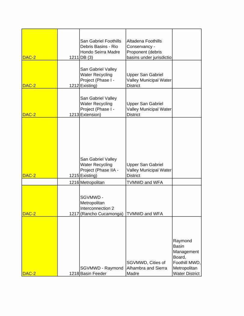
DAC-2 1211
San Gabriel Foothills Debris Basins - Rio Hondo Seirra Madre DB (3)
Altadena Foothills Conservancy - Proponent (debris basins under jurisdictio
DAC-2 1212
San Gabriel Valley Water Recycling Project (Phase I -Existing)
Upper San Gabriel Valley Municipal Water District
DAC-2 1213
San Gabriel Valley Water Recycling Project (Phase I - Extension)
Upper San Gabriel Valley Municipal Water District
DAC-2 1215
San Gabriel Valley Water Recycling Project (Phase IIA - Existing)
Upper San Gabriel Valley Municipal Water District
1216SGMetropolitan TVMWD and WFA
DAC-2 1217
SGVMWD - Metropolitan Interconnection 2 (Rancho Cucamonga) TVMWD and WFA
DAC-2 1218SGVMWD - Raymond Basin Feeder
SGVMWD, Cities of Alhambra and Sierra Madre
Raymond Basin Management Board, Foothill MWD, Metropolitan Water District

1219
Six Basin Comprehensive Groundwater Improvement Project
TVMWD & Six Basins Watermaster
Six Basins Watermaster City of Upland Golden State Water Company San Antonio Water Company City of Pomona
1220
Six Basin Comprehensive Groundwater Improvement Project Phase 2
TVMWD & Six Basins Watermaster
DAC-2 1221
Spread Imported Treated Water for Groundwater Recharge Location 1
Raymond Basin Producers, Raymond Basin Management Board
DAC-2 1222
Spread Imported Treated Water for Groundwater Recharge Location 2
Raymond Basin Producers, Raymond Basin Management Board
1224
Treatment Plant Projects for Perchlorate & VOCs Location 2 City of Monterey Park
1225
Treatment Plant Projects for Perchlorate & VOCs Location 3 City of Monterey Park
1226
Treatment Plant Projects for Perchlorate & VOCs Location 4 City of Monterey Park
Inactive 1228
Use of Artificial Turf as a Landscape Option Location 2 Watermaster
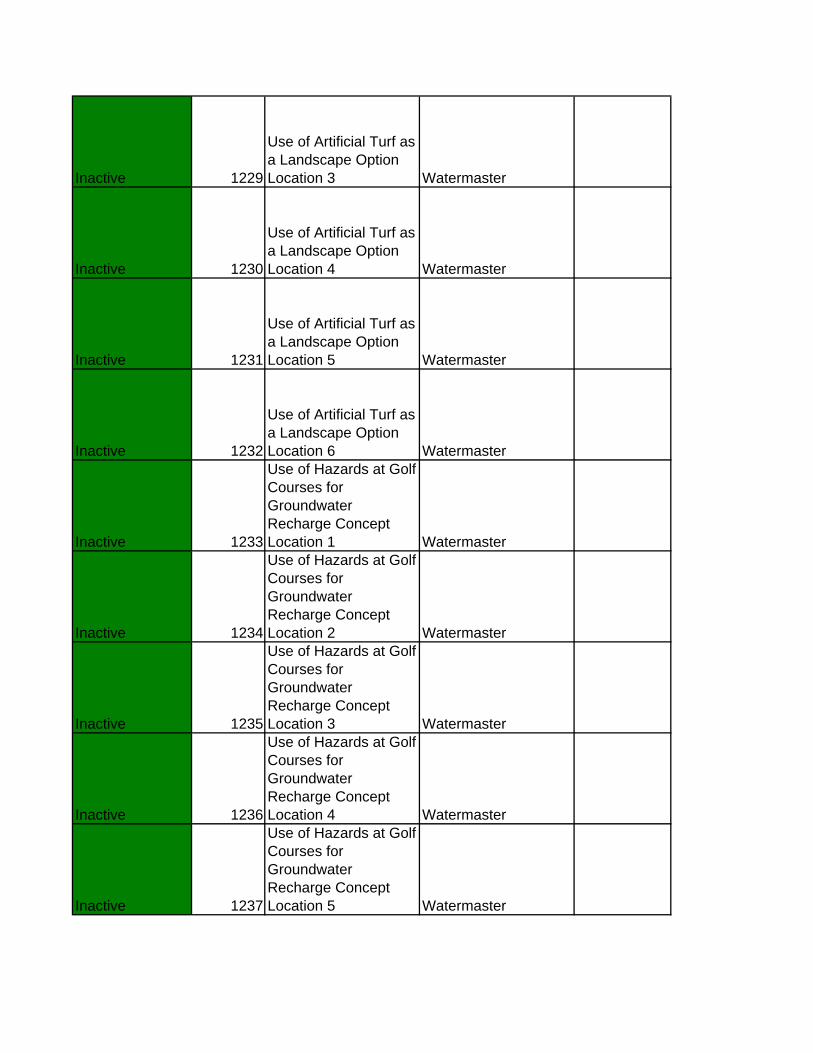
Inactive 1229
Use of Artificial Turf as a Landscape Option Location 3 Watermaster
Inactive 1230
Use of Artificial Turf as a Landscape Option Location 4 Watermaster
Inactive 1231
Use of Artificial Turf as a Landscape Option Location 5 Watermaster
Inactive 1232
Use of Artificial Turf as a Landscape Option Location 6 Watermaster
Inactive 1233
Use of Hazards at Golf Courses for Groundwater Recharge Concept Location 1 Watermaster
Inactive 1234
Use of Hazards at Golf Courses for Groundwater Recharge Concept Location 2 Watermaster
Inactive 1235
Use of Hazards at Golf Courses for Groundwater Recharge Concept Location 3 Watermaster
Inactive 1236
Use of Hazards at Golf Courses for Groundwater Recharge Concept Location 4 Watermaster
Inactive 1237
Use of Hazards at Golf Courses for Groundwater Recharge Concept Location 5 Watermaster
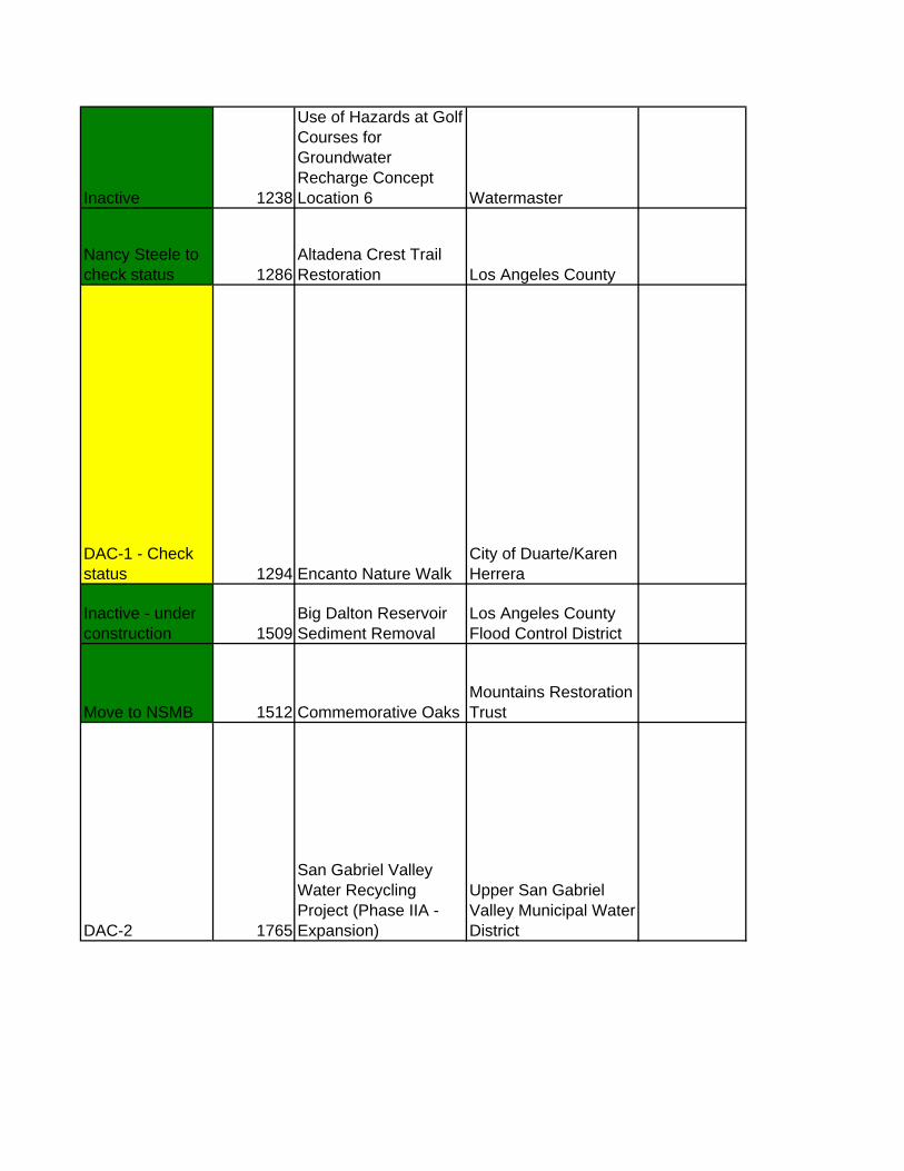
Inactive 1238
Use of Hazards at Golf Courses for Groundwater Recharge Concept Location 6 Watermaster
Nancy Steele to check status 1286
Altadena Crest Trail Restoration Los Angeles County
DAC-1 - Check status 1294 Encanto Nature Walk
City of Duarte/Karen Herrera
Inactive - under construction 1509
Big Dalton Reservoir Sediment Removal
Los Angeles County Flood Control District
Move to NSMB 1512 Commemorative OaksMountains Restoration Trust
DAC-2 1765
San Gabriel Valley Water Recycling Project (Phase IIA - Expansion)
Upper San Gabriel Valley Municipal Water District

DAC-2 1766
San Gabriel Valley Water Recycling Project (Phase IIB - New)
Upper San Gabriel Valley Municipal Water District
DAC-2 1767
San Gabriel Valley Water Recycling Project (Phase III - Future)
Upper San Gabriel Valley Municipal Water District
1896
The Southeast San Gabriel Valley Groundwater Supply Project
Walnut Valley W.D., Rowland W.D.
1902 Trail Connections Plan
Rivers and Mountains Conservancy, La Habra Heights
Inactive 1927Wildwood Canyon-San Dimas RMC
DAC-1 - needs update 1952 Duck Farm Phase 1A
Watershed Conservation Authority, RMC
DAC-1 1953 Duck Farm Phase 1B
Watershed Conservation Authority, RMC
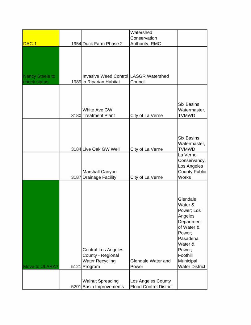
DAC-1 1954 Duck Farm Phase 2
Watershed Conservation Authority, RMC
Nancy Steele to check status 1989
Invasive Weed Control in Riparian Habitat
LASGR Watershed Council
3180White Ave GW Treatment Plant City of La Verne
Six Basins Watermaster, TVMWD
3184 Live Oak GW Well City of La Verne
Six Basins Watermaster, TVMWD
3187Marshall Canyon Drainage Facility City of La Verne
La Verne Conservancy, Los Angeles County Public Works
Move to ULARA? 5121
Central Los Angeles County - Regional Water Recycling Program
Glendale Water and Power
Glendale Water & Power; Los Angeles Department of Water & Power; Pasadena Water & Power; Foothill Municipal Water District
5201Walnut Spreading Basin Improvements
Los Angeles County Flood Control District
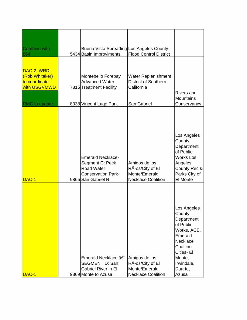
Combine with 664 5434
Buena Vista Spreading Basin Improviments
Los Angeles County Flood Control District
DAC-2; WRD (Rob Whitaker) to coordinate with USGVMWD 7815
Montebello Forebay Advanced Water Treatment Facility
Water Replenishment District of Southern California
RMC to update 8338 Vincent Lugo Park San Gabriel
Rivers and Mountains Conservancy
DAC-1 9865
Emerald Necklace-Segment C: Peck Road Water Conservation Park-San Gabriel R
Amigos de los RÃ-os/City of El Monte/Emerald Necklace Coalition
Los Angeles County Department of Public Works Los Angeles County Rec & Parks City of El Monte
DAC-1 9869
Emerald Necklace – SEGMENT D: San Gabriel River in El Monte to Azusa
Amigos de los RÃ-os/City of El Monte/Emerald Necklace Coalition
Los Angeles County Department of Public Works, ACE, Emerald Necklace Coaltion Cities- El Monte, Irwindale, Duarte, Azusa

Move to ULARA? 10269
PHASE 1 - Central Los Angeles County - Regional Water Recycling Program
Glendale Water and Power
Glendale Water & Power, Los Angeles Department of Water & Power, Pasadena Water & Power
DAC-1 10788Green Collar Youth Training Program Amigos de los Rios
Southern California Edison, Upper San Gabriel Municipal Water District, Metropolotain Water District, Central San Gabriel Valley WorkSource, Career Partners (One-
DAC-1 10832
San Gabriel River Discovery Center Overlook Amigos de los Rios
Los Angeles County Department of Public Works, Los Angeles County Parks and Recreation

DAC-1 10866Gibson Mariposa Multi-Benefit Park Amigos de los Rios
City of El Monte, Mujeras de la Tierra, Resource Legacy Fund, California Community Foundation
DAC-1 10965
Emerald Necklace-Segment E: Ramona Blvd to Whittier Narrows
Amigos de los RÃ-os/Emerald Necklace Coalition
Los Angeles County Department of Public Works Los Angeles County Rec & Parks City of El Monte
DAC-1 11246
San Gabriel River Discovery Center Authority
Rivers and Mountains Conservancy
US Army Corps of Engineers
Need to Update 11492San Jose Creek Multi-Purpose Corridor LASGRWC

ProjectDescription ContactFirstName
This educational project would develop a Watershed U. training program for Rio Hondo. Watershed U. is designed to increase communication among watershed stakeholders, and to engage local decision makers in the process. Sabrina
This educational project would develop a Watershed U. training program for the San Gabriel River. Watershed U. is designed to increase communication among watershed stakeholders, and to engage local decision makers in the process. Sabrina
The project involves developing river front park(s) along River Drive Road, engaging and educating residents living in Cudahy about stormwater issues through a community mural, and providing a stormwater filtration system to help improve water quality in the County of Los Angeles River. Saul
The Santa Anita Dam Seismic Rehabilitation Project will upgrade Santa Anita Dam to comply with DSOD’s design requirements for seismic stability and spillway adequacy. Our consultant has developed three concepts for the rehabilitation: (1) a full rehabilitation consisting of a full concrete buttress on the downstream face, to elevation 1300; (2) a partial rehabilitation consisting of a partial concrete buttress on the downstream face, to elevation 1270; and (3) a riser modification that will allow for a long-term maximum reservoir level at elevation 1230. The operating guidelines for the dam will be modified for maximum water conservation benefits. Keith
The Santa Anita Debris Dam Seismic Rehabilitation Project will updrade the debris dam to comply with DSOD's requirements for seismic stability. Our consultant has developed three concepts for the rehabilitation: (1) a full rehabilitation consisting of relocation of the spillway and a new outlet tower; (2) a partial rehabilitation consisting of lowering the spillway invert to remove the debris dam from DSOD's jurisdiction and constructing a trash rack across the span of the spillway to provide sufficient sediment capacity; and (3) debris retention which consists of strengthening the outlet tower and spillway walls. The operating guidelines will be modified for maximum water conservation benefits. Keith
s

Develop wetland habitat on the south side of Peck Lake to improve water quality. Also utilize techniques to increase groundwater recharge within the basin. Vik
Work with Cities of Arcadia, Monrovia, and Sierra Madre to develop a subregional solution at Peck Park for Trash TMDL compliance. Vik
Develop a subregional trash capture BMP for the RIO_HONDO subwatershed in compliance with the LAR Trash TMDL Vik
Construction of a dam within the existing spillway at San Gabriel Dam to increase the maximum storage capacity of the reservoir by between 4500 acre-feet and 6500 acre-feet. Keith
Construction of a dam within the existing spillway at Cogswell Dam to increase the maximum storage capacity of the reservoir by between 1200 acre-feet and 1800 acre-feet. Keith
Construction of additional interconnections for emergency sources of supply for the City of Sierra Madre and/or other water systems Bruce
Preparation of construction drawings and construction implementation for naturalization of Alhambra Wash. The construction phase will naturalize the box channel of Alhambra Wash between Walnut Grove Ave. and the Alhambra Oasis at the Alhambra Wash-Rio Hondo confluence. Construction will implement improved habitat and recreation along this segment of the wash, restoring pieces of aquatic and terrestrial habitat and enhancing public access through trail development. The project will provide a model for naturalizing some Southern California waterways. Claire
Develop and design construction drawings to naturalize parts of the channel that passes through the Whittier Narrows Golf Course. Other features include native landscaping, a trail, benches, educational signage, bridges, and other amenities Claire

The Alosta Connection requires the construction of a new pipeline or interconnection between MWD’s Rialto Feeder (a raw water pipeline) and SGVMWD’s pipeline in San Dimas near its hydro plant. This interconnection would allow SGVMWD or MWD to deliver water to Azusa and/or into Raymond Basin year round without impacting SGVMWD ability to make power. Connections could be made both on the pressurized Rialto Feeder and gravity flow La Verne Pipeline. This project is an essential element of the plan to extend the SGVMWD pipeline. The project will be operated for the mutual benefit of water supply for MWD and SGVMWD. Tim
The project is a groundwater treatment facility utilizing air-stripping technology for the removal of volatile organic compound contamination. The treated water is conveyed into AMWC's existing distribution system. Grace
Develop a safer passage across Arrow Highway for SGR Bike trail users. Alternatives include building a new bridge over Arrow Highway, or going underneath through an existing tunnel, which needs repairs. Lani
The project consists of a barren hillside and Caltrans' flood control channel which runs on the west side of the 710 Freeway. The project will involve the naturalization of the channel and include open space enhancements such as a multipurpose trail and native landscaping. Overall, the project will proved multiple benefits related to recreation, improved water recharge, and open space enhancements in an urban environment. NA

Project will develop a system of street-side bicycle paths to help bicyclists enter Azusa Canyon from Sierra Madre Avenue or Azusa Canyon Road & connect to the San Gabriel River Trail. NA
The Azusa River Wilderness Park is a project to create a passive park on the north end of the City of Azusa at the beginning of San Gabriel Canyon. The envisioned park is 89 acres in size with acreage on both sides of the San Gabriel River. Currently 41.5 acres have been purchased. There are opportunities to work with a variety of agencies and to connect to several trails that travel into the Angeles Forest as well as the San Gabriel River Bike Path that travels the length of the river and whose terminus is in Seal Beach. Jane
Baldwin Park will improve the existing Barnes Park with habitat enhancements & an interpretive programs center. NA
Project will redesign irrigation system and parking lot. NA
Site will be used for a multi-purpose staging area where trail users can park trailers and vehicles and provide a stop along the trail. NA
Replace the intake structure at Big Dalton Spreading Grounds to better control and measure flows taken into the facility. Install perimeter landscaping for aesthetics. Optimize basin configuration. Ken
The Rio Hondo Bicycle Trail currently ends in Peck Park, extending this trail to the San Gabriel. River would both allow direct access to the Rio Hondo trail from the San Gabriel. River Bike Trail and complete a recreational loop trail approx 15 miles in length that would link the two regional trails at Whittier Narrows and Peck Park. Security Fencing and native plant landscaping would be provided to screen views and access to the quarry. NA
On behalf of the Fly Fishers Club of Orange County, a funded research study conducted by consultants of the San Gabriel Mountains Regional Conservancy is evaluating the river's black fly populations, a source of fish food. NA
Prefabricated 60 foot bridge for pedestrian and equestrian access over Upper Live Oak Creek. NA
A reclamationplan for the quarry is in progress. NA

This project will create bio-engineered wetlands for habitat restoration in a LACDPW spreading basin west of Santa Fe Dam. A conveyor line, operated by United Rock Products, runs across the westerly part of this property. The design and implementation of the wetlands will need to ensure the continued safe operation of this conveyor. Lani
The project is a groundwater treatment facility utilizing air-stripping, ion exchange and ultraviolet oxidation technologies for the removal of VOCs, perchlorate, n-nitrosdimethylamine and 1,4-Dioxane contamination. Grace
The Baldwin Park project will upgrade an existing 2-acre righ-of-way with lanscaping & trails to connect Buena Park, the San Gabriel River Bike Trail & neighorhood schools NA
Enhancement of recharge facilities within Raymond Basin Tony
Restore California native vegetation/remove broken concrete drainage pipes, Improve channel hydraulics Amy
Upgrade of CIC tmt plant Mike
Construct a pipeline from Ben Lomand Spreading Grounds located along San Dimas Wash to Citrus Spreading Grounds located along Big Dalton Wash. Ken
Install at Citrus Spreading Grounds telemetry at uppermost intake gates and link with current rubber dam telemetry at the facility; improve existing landscaping around the facility’s perimeter; establish bike path along facility’s existing paved access road; construct a 1.8-mile long porous pavement bike path along Big Dalton Wash between Barranca and Cerritos Avenues; replace existing pedestrian footbridge at school; plant trees along bike path to match existing trees at spreading grounds. Patricia
The project is a groundwater treatment facility. Grace
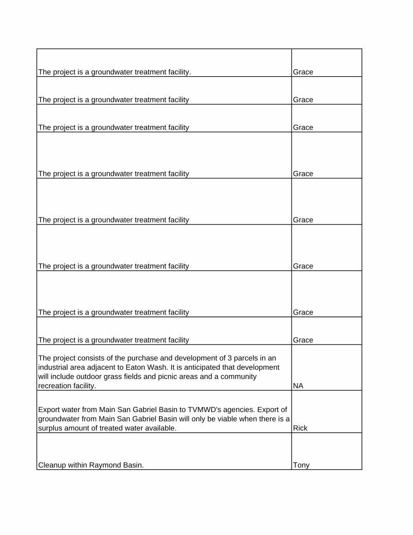
The project is a groundwater treatment facility. Grace
The project is a groundwater treatment facility Grace
The project is a groundwater treatment facility Grace
The project is a groundwater treatment facility Grace
The project is a groundwater treatment facility Grace
The project is a groundwater treatment facility Grace
The project is a groundwater treatment facility Grace
The project is a groundwater treatment facility Grace
The project consists of the purchase and development of 3 parcels in an industrial area adjacent to Eaton Wash. It is anticipated that development will include outdoor grass fields and picnic areas and a community recreation facility. NA
Export water from Main San Gabriel Basin to TVMWD's agencies. Export of groundwater from Main San Gabriel Basin will only be viable when there is a surplus amount of treated water available. Rick
Cleanup within Raymond Basin. Tony
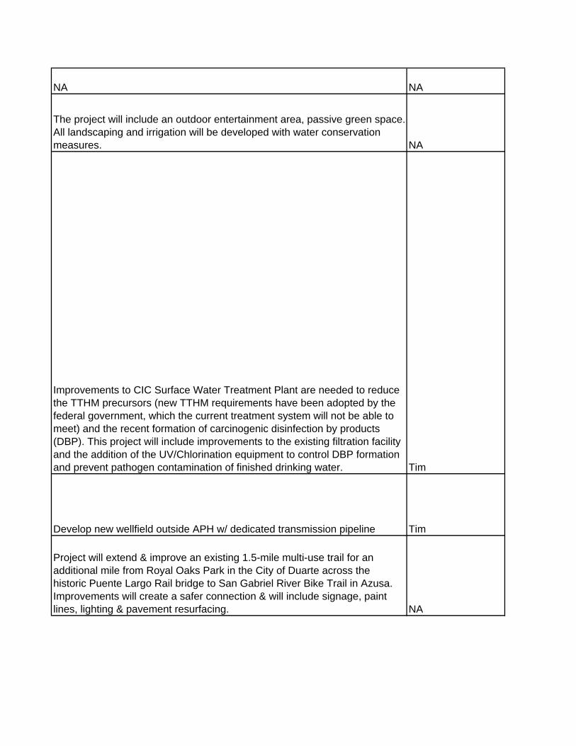
NA NA
The project will include an outdoor entertainment area, passive green space. All landscaping and irrigation will be developed with water conservation measures. NA
Improvements to CIC Surface Water Treatment Plant are needed to reduce the TTHM precursors (new TTHM requirements have been adopted by the federal government, which the current treatment system will not be able to meet) and the recent formation of carcinogenic disinfection by products (DBP). This project will include improvements to the existing filtration facility and the addition of the UV/Chlorination equipment to control DBP formation and prevent pathogen contamination of finished drinking water. Tim
Develop new wellfield outside APH w/ dedicated transmission pipeline Tim
Project will extend & improve an existing 1.5-mile multi-use trail for an additional mile from Royal Oaks Park in the City of Duarte across the historic Puente Largo Rail bridge to San Gabriel River Bike Trail in Azusa. Improvements will create a safer connection & will include signage, paint lines, lighting & pavement resurfacing. NA

The grant provides for further geotechnical sampling on the Woodland Duck Farm property and independent analysis of the sampling results. The primary deliverable, a geotechnical report on the porosity of the underground strata will determine the feasibility of groundwater recharge at the site. Frank
Adjacent to Gordon Mull open space acquisition project. Upgrades and enhances the Gordon Mull with Tongva Native American excavation site, artifacts, wildlife cache-natural springs, ponds. House,/museum/nature center on site. NA
Assist in creating a sustainable, educational water feature connecting the plaza through open space NA
Total cost for the plan is $375,000. $168,750 is being requested from the RMC. Rehabilitation of various water systems within the Raymond Basin. This project will make improvements to the Santa Anita Diversion structures, rehabilitate the diversion pipeline, rehabilitate the Sierra Madre Creek Diversion structures, and the Sierra Madre Spreading Grounds. Estimated total capital costs: About $90 million. NA
Plans to extend City of Industry's reclaimed water distribution system from San Jose Creek WRP into West Covina, Diamond Bar, and the Rowland Water District, and connect to the Walnut Valley Water District reclaimed water system emanating from Pomona WRP. Dave
The project is a groundwater treatment facility. Grace
The project is a groundwater treatment facility. GraceInstall a rubber dam in Eaton Wash channel to direct flows into Eaton Wash Spreading Grounds. The rubber dam would replace the current method of utilizing a drop inlet. The telemetry system would enable staff to optimize operations for real time conditions. Ken
Acquisition of land along Valley Boulevard for use as a nature park featuring oak woodlands, riparian habitat, educational displays, and meandering pathways. NA

The development of the concept plans for the 39.9 acre portion of the Azusa River Wilderness Park. JanePlanning to strategically map highly utilized multi-use pathways and corridors connecting existing city services to the rivers and tributaries that border the City and surrounding areas. NA
The project includes daylighting the two storm drains, as well as strategic retrofitting of adjacent parking lots and street edges to increase the permeability of surface pavement and local water storage capacity. Permeable concrete paving and native plant vegetation on street edges, parking lots, and parking islands decrease the amount of surface runoff to storm water systems, and clean water as it runs through permeable areas, also reducing heat island effects on surrounding microclimates. The parking lot and street edge conversions, in conjunction with bioswale/stream naturalization projects, provide incremental water quality improvement benefits along the project areas, reducing downstream impacts. The projects address TMDL legislation mandates, increase permeability and ground water infiltration, reduce storm water load to the channel, address long term flood management issues, and provide recycled water for irrigation, beautification, and recreation. Claire
Landscaping, restoring & beautifying areas along Rio Hondo Claire
Landscaping, restoring & beautifying areas along Rio Hondo Claire
Restore and beautify 6 acres & include community park Claire
Landscaping, restoring & beautifying areas along Rio Hondo, Implementing mile markers along bike trail. Claire
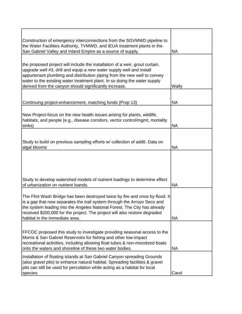
Construction of emergency interconnections from the SGVMWD pipeline to the Water Facilities Authority, TVMWD, and IEUA treatment plants in the San Gabriel Valley and Inland Empire as a source of supply. NA
the proposed project will include the installation of a weir, grout curtain, upgrade well #3, drill and equip a new water supply well and install appurtenant plumbing and distribution piping from the new well to convey water to the existing water treatment plant. In so doing the water supply derived from the canyon should significantly increase. Wally
Continuing project-enhancement, matching funds (Prop 13) NA
New Project-focus on the new health issues arising for plants, wildlife, habitats, and people (e.g., disease corridors, vector control/mgmt, mortality sinks) NA
Study to build on previous sampling efforts w/ collection of addtl. Data on algal blooms NA
Study to develop watershed models of nutrient loadings to determine effect of urbanization on nutrient loands. NA
The Flint Wash Bridge has been destroyed twice by fire and once by flood. It is a gap that now separates the trail system through the Arroyo Seco and the system leading into the Angeles National Forest. The City has already received $200,000 for the project. The project will also restore degraded habitat in the immediate area. NA
FFCOC proposed this study to investigate providing seasonal access to the Morris & San Gabriel Reservoirs for fishing and other low-impact recreational activities, including allowing float tubes & non-morotized boats onto the waters and shoreline of these two water bodies. NA
Installation of floating islands at San Gabriel Canyon spreading Grounds (also gravel pits) to enhance natural habitat. Spreading facilities & gravel pits can still be used for percolation while acting as a habitat for local species. Carol

New untreated water svc connection off MWD Foothill feeder. Mike4 southern National Forests including Ageles, San Bernardino, Los Padres and Cleveland are updating their Master Plans. Plans address issues of resource mgt, recreational access issues, habitat & other concerns of forest stakeholders. NA
New GW well w/ ion exchange wellhead treatment & storage MikeCounty DPW strip of land located along Blue Line, to be developed as a pedestrian walkway; small pocket park to be developed on one privately owned adjacent property. NADevelopment of family camp, making it a fully functional ADA accessible campground. The trails, restrooms, and signage will be upgraded. Landscaping will also be enhanced with native plants. Frank
3 to 4 new GW wells w/ treatment plant for nitrate & VOC removal Jim
Part of the Emerald Necklace, Gibson Park grant from the RMC will fund native landscaping, an outdoor interpretive kiosk and an outdoor classroom where visitors and school children can learn about the natural history and resources of this watershed area. NA
Afternoon and weekend park programs at school sites. Gidley School is the only site in this region of the city large enough to host a large array of active sports. However being barren of vegetation, it is an undesirable location for passive recreation. The proposal is to enhance the site with drought-tolerant vegetation, a multiuse path and picnic areas. NA
Extension of Three Valleys PM-26 untreated water svc. Mike
The project is a groundwater treatment facility. Grace
The project is a groundwater treatment facility. Grace

The project is a groundwater treatment facility. Grace
Determine potential as new open space for restoration, habitat, and economic development NA
This Phase II project is to implement the major tasks identified in the Phase I framework, to identify and assess opportunities for habitat conservation and restoration, open space acquisition and recreational facilities development, and watershed protection efforts. The GIS planning tool and data sets will also be created. To retain its utility, the data infrastructure associated with this tool will need to be managed. This phase of the project will span at least two years, with a start date of January 1, 2005. NA
Development of a docent program and manual to be used by the Puente Hill Landfill Native Habitat Authority Docent Program for the Puente Hills Region. NA
Project will provide a habitat linkage at this "pinchpoint" to complete the Puente Hills to san Gabriel Mountains habitat corridor. The U.S. Army Corps of Engineers (ACE) owns key parcels in this area. ACE is willing to partner with other agencies & private groups to identify opportunities for creating this linkage. NA
Construct a rubber dam & concrete chutes at Hanson Pit. Any storm water or runoff can be put into Hanson Pit & percolated for groundwater recharge. Tim
The City of Irwindale is interested in multiple possible uses for the 400 acre Hanson Quarry site, which offers a significant economic development opportunity. A long-term quarry reclamationplan is being developed to be implemented once mining operations have ceased, including new business & industrial uses, shopping, parks & open sapce, and possibly groundwater recharge and cleanup. NA
A portion of the east trail, bridge and interpretive signage along with benches and picnic tables at Heritage Garden Park. NA
The project is a groundwater treatment facility. Grace
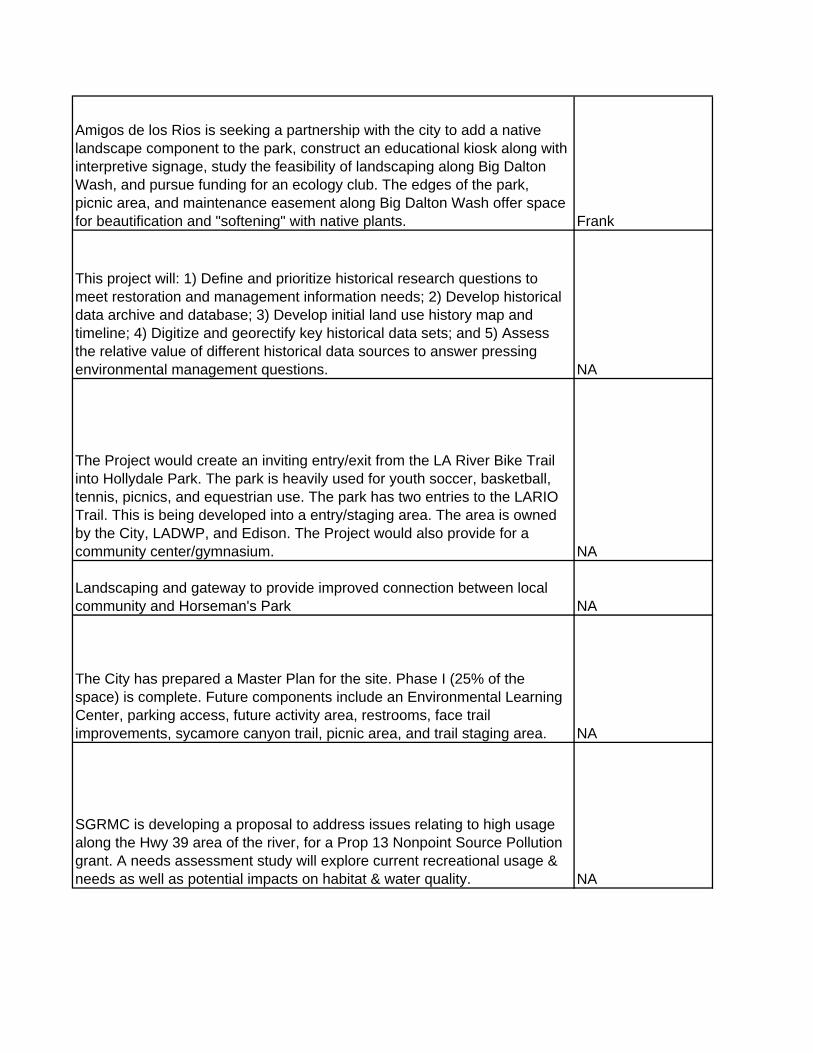
Amigos de los Rios is seeking a partnership with the city to add a native landscape component to the park, construct an educational kiosk along with interpretive signage, study the feasibility of landscaping along Big Dalton Wash, and pursue funding for an ecology club. The edges of the park, picnic area, and maintenance easement along Big Dalton Wash offer space for beautification and "softening" with native plants. Frank
This project will: 1) Define and prioritize historical research questions to meet restoration and management information needs; 2) Develop historical data archive and database; 3) Develop initial land use history map and timeline; 4) Digitize and georectify key historical data sets; and 5) Assess the relative value of different historical data sources to answer pressing environmental management questions. NA
The Project would create an inviting entry/exit from the LA River Bike Trail into Hollydale Park. The park is heavily used for youth soccer, basketball, tennis, picnics, and equestrian use. The park has two entries to the LARIO Trail. This is being developed into a entry/staging area. The area is owned by the City, LADWP, and Edison. The Project would also provide for a community center/gymnasium. NA
Landscaping and gateway to provide improved connection between local community and Horseman's Park NA
The City has prepared a Master Plan for the site. Phase I (25% of the space) is complete. Future components include an Environmental Learning Center, parking access, future activity area, restrooms, face trail improvements, sycamore canyon trail, picnic area, and trail staging area. NA
SGRMC is developing a proposal to address issues relating to high usage along the Hwy 39 area of the river, for a Prop 13 Nonpoint Source Pollution grant. A needs assessment study will explore current recreational usage & needs as well as potential impacts on habitat & water quality. NA

Increased deliveries through USG-5 would be funded by in-lieu assessments; imported CWEA water will be purchased in-lieu of pumping, which will reduce drawdown in the Main San Gabriel Basin. Darin
New well development Alice
The project involved making preliminary findings regarding project opportunities and related criteria for the Integrated Regional Water Management Plan for the San Gabriel and Lower Los Angeles River Watershed Region NA
We will identify and map the populations of concern throughout Los Angeles County. Undesirable invasive non-native plants will be selectively controlled by targeted herbicide applications, requiring minimal cutting and biomass reduction, extending and expanding previous habitat restoration work. Work is required throughout the upper watersheds, and extending to the ocean, e.g., Millard Canyon, Rio Hondo Riparian Corridor, San Gabriel; river channel at Whittier Narrows, Whittier Narrows Nature Center, Santa Fe Dam Basin and San Gabriel; river channel in Azusa, and Eaton Canyon Nature Center. Pre- and post-project monitoring, including mapping, is necessary to achieve long term success. Nancy
The existing pool of water will be pumped to Manning Pit. The accumulated sediment in Irwindale Spreading Basin will be removed and deposited at Manning SPS. A drain will be constructed to allow the annual drying out of Irwindale Basin so the bottom can be ripped and excess sediment removed to maintain optimum percolation rates. Ken
The project is a continuation of the joint efforts of the City and the Claremont Wildlands Conservancy adn other agencies to preserve the properties East and West of Johnson's pasture as permanent open space. The project will help complete the wildlife corridor from the USFS from San Antonio Canyon in the east to Marshall Canyon to the west. The projects include multiple owners and parcels vary in size from 3 acres to more than 150 acres. Jane
The project is a groundwater treatment facility Grace

In cooperation with the Corps of Engineers, develop hydraulic and hydrologic model(s) for the Los Angeles and San Gabriel River watersheds. Following development of a model, a plan will be developed to ensure future developments do not compromise the authorized level of flood protection in the LACDA Project area. The implementation of the project will involve various stakeholders and jurisdictions. Vik
DPW withdrew project from consideration for grant funds. Project however, will be discussed and considered for implementation in NPS study (2005) NAThis project proposes to transform a man-made water supply ditch into a natural meandering stream course (naturalize streambed, increase habitat value by planting native trees and understory along banks, use non-structural bioengineering methods to stabilize banks), providing passive/low impact recreational opportunities including trail links, interpretive signage, cultural and environmental education displays, and outdoor classroom settings. Lani
This grant will provide restoration of an area of North Legg Lake by implementing a shoreline restoration program which includes ADA parking, an access walkway and ramp, an informational kiosk and native landscaping. NA
Create a retention/recharge facility behind the headworks of the Live Oak Wash Channel, which is adjacent to Live Oak Spreading Grounds. Ken
West Fork Working Group (WFWG) Plan addresses mgt of the West Fork, including cogswell Reservoir. WFWG includes the USDA Forest Service, LADPW, Calif Dept of Fish & Game, Calif. Trout, Inc., Main San Gabriel Basin Watermaster, San Gabriel Valley Protective Assn, and San Gabriel Water Committee. 6 objectives of the Plan include flood control, dam safety, water rights, fisheries optimization, recreation & land use mgt. NA
Construction of VOCs treatment facilities w/in USGVMWD's service area. Tim
See #53 above NA
Master Plan/Biological Assessment for the Maverick/Ridge Rider park area along Walnut Creek. NA

The Metrolink station is located approximately one-third of a mile from the Rio Hondo Bike Trail. Providing a connecting grail between the River and the MTA station would allow regional bike trail and public transportation users to gain access to the Metrolink trains by bicycle and to the river via public transportation. NA
Mission Creek drains from Legg Lake. The project calls for stabilization of the banks, the installation of a debris boom, and the reintroduction of native plants. NA
See #97 Above NA
This project is an acquisitioni of habitat/open space. This is the largest open space property privately owned in the Whittier Narrows (480 acres) located just to the west of the dam. It has been reported that this property contains a significant gnatcatcher population. The City is updating it's general plan and expects that this site will ultimately include habitat, open space, commercial and housing elements. This project would put this acreage into public hands and provide passive recreation with miles of trails, areas on the property could be utilized as water conservation areas as well as water quality improvement areas utilizing bio swales or constructed wetlands. Jane
The largest available open space along Angeles National Forest section of the river, this 40-acre peninsula juts into the Morris reservoir at the former site of a Navy torpedo testing facility adjacent to Highway 39. This site can be reclaimed and developed for recreational day-use, overnight camping, trails and a forest and/or historic interpretive center. The development of this site would provide needed park facilities with parking and other site amenities to relieve the serious weekend congestion of Forest visitors. Lani
Project entails physical modifications to the Morris Dam Inlet/Outlet Works and control systems to facilitate a lower operational reservoir pool and the reliable conjunctive management of the resulting increased conserved water. Keith
To naturalize by removing non-pervious material from the bottom of the storm channels, transitioning sides from concrete to natural stone & installing bridle paths and trees. Carol
Construction of a new interconnection w/City of Alhambra Victor

Construction of a new well in the Main San Gabriel Basin to pump groundwater to Sierra Madre's wellfield/distribution facility through a new transmission pipeline Bruce
Coordinate the application for surplus property from the National Park Service of Nike Site 29, parcel 2. Once the Nike Site is acquired the staff will coordinate the agreements for operation and maintenance of the site as well as long term ownership of the property. Jane
The project is a groundwater treatment facility. Grace
The project is a groundwater treatment facility. Grace
Azusa Canyon Off-Roaders Assn is proposing improvements to existing steam crossing & habitat restoration for the Santa Ana sucker to minimize impacts from off-road vehicle use, while providing selected amenities for the benefit of off-hwy enthusaists & other river visitors. NA
Construction of diversion works from Big Dalton Wash to Olive Pit. Water conveyed to Olive Pit will be percolated into the groundwater basin. Tim
New well development Alice

Planned Improvements to Park include a reclaimed water irrigation system, improved parking lot and BMP swale, 40 acres of habitat restoration, 2 miles of multi-use trail creation or enhancement including lookout vistas & amenities ( bike, equestrian, pedestrian, floodable trail bridge), & 25 acres of recreational space enhancement, educational interpretive signage. Trails are critical connections to regional trail resources, and a critical segment of the Emerald Necklace. The Park also includes an 80 acre lake which is host to 303 myriad birds and aquatic species that have been counted. There are approximately 35 to 40 acres of potential habitat restoration areas around the perimeter of the lake in excess of the maintenance road areas required by the Flood Division) that need to be revegetated to support habitat and open space restoration. Compatible with County Flood plans for zone. ClaireFunding will be used to develop a native habitat demonstration garden to provide an example of future improvements in the park, such as drought-tolerant and native plants from several different ecosystems, a meandering pathway, signage, benches, and tables and a model of sustainable landscaping for local residents. NA
Complete update of outreach, scoping & design development/construction drawings for Peck Park to maximize benefits of this facility. Planned improvements to park include reclaimed water irrigation system, improved parking lot and BMP swale, 40 acres of habitat restoration, 2 miles of multi use trail creation or enhancement including lookout vistas & amenities (bike, equestrian, pedestrian, floodable trail bridge), & 25 acres of recreational space enhancement, educational interpretive signage. Trails are critical connections to regional trail resources, critical segment of the Emerald Necklace. The Park also includes an 80 Acre Lake which is host to myriad birds and aquatic species–303 species have been counted. There are approximately 35-40 acres of potential habitat restoration areas around the perimeter of the lake in excess of the maintenance road areas required by the Flood Division that need to be revegetated to support habitat, open space restoration. Compatible with County Flood plans for zone. Claire
Modernization of spreading grounds for more GW recharge in 6 basin Jim
Feasibility study for upgrading existing Hardlinge Filter Plant Jim

Construct wetlands to treat low-flows from Live Oak Wash, Marshall Canyon, and Puddingstone channels prior to discharge into Puddingstone Reservoir to enhance water quality and beneficial uses of the reservoir. The project will also provide passive/low impact recreational opportunities including trails with interpretive signage and outdoor classroom settings. Lani
Provides critical linkage for interconnected urban wildlife corridor between Puente Hills and Whittier Narrows; acquisitions to link up publicly protected land to help complete the Puente-Chino Hills Wildlife Corridor Andrea
Project will create a habitat movement corridor between the Puente-Chino Hills & Chino Hills state park, connecting to the currently preserved publicly held habitat of over 3,000 acres. Andrea
This project is a study to evaluate the ecological implications of habitat fragmentation that may occur in the area between Harbor Blvd and Tonner Canyon. NA
The Upper SGV MWD, Sierra Club, & the State of Calif. Rivers and Mountains Conservancy (RMC) initiated a study to identify potential reuse of gravel quarries for multiple purposes after mining is completed, including storm water capture & cleanup, recharge of storm water and imported water, flood reduction, recreation & habitat restoration, as well as aesthetic improvements. Tim
The Ramona Blvd gateway project will provide a key entry point to the San Gabriel River bike Trail & the City of El Monte NA
Implementation of the Rio Hondo Watershed Management Plan (RHWMP) provides an organizing framework for community stakeholders working together to develop a healthy watershed within the densely developed urban environment of the San Gabriel Valley. The RHWMP contains an overview of existing conditions within the watershed, discusses how these conditions should shape the selection and design of watershed improvement strategies, and presents recommended projects and other solutions proposed by community stakeholders who developed this watershed plan. Frank

Rehabilitation of unused land between Rio Vista School and several houses transforming it into an additional entrance from Bisby Street through a narrow swale. The land will be developed into a native plant garden featuring drought tolerant plants, benches), and signage. NAHabitat restoration & park expansion in the canyon area behind Mountain Cove. NA
Public Access to Robert's Creek will be provided aound or and behind Mountain Cove private residential development, from Azusa Canyon River Park and/or the San Gabriel River Bike Trail Extension. Jane
Foothill property located to the west of Fish Canyon. Possible acquisition opportunity. Has significant views, there are existing fire roads for hiking, biking and equestrian use. Provides Forest Service area linkage. If this property is lost to development or to minining operations the viewshed from the entire San Gabriel Valley will be lost. Jane
Installation of a series of small rubber dams to capture runoff in channels. Carol
Restore the spreading basins that were washed out by the Jan 2005 Storm. New basins will be configured for more efficient operation; a bypass channel will be included to minimize large storm impacts to basins in the future. Ken
The project is a groundwater treatment facility. Grace
This project will study possibilities for providing landscaping, native habitat restoration, decorative fencing, interpretive signage, trails and other park amenities for public enjoyment and education. The 165-acre site project will be compatible with the groundwater recharge function of the two basins. Due to the deepness of the two basins, and the fact that it is a major water supply for Azusa, health and safety issues will be key project determinants. Dan
Update this 1992 LACDPW study that investigated expanding non-water oriented recreational activities at or near the reservoir. Its recommendations need to be updated in light of today’s increased security considerations. Dan

An environmental beautification opportunity for the City of Irwindale in partnership with the Hollywood Beautification Team. This 1.4-mile enhancement of the existing bike trail would inclue a bike staging area & other improvements designed to provide a better interface between the Santa Fe Dam and the San Gabriel River Bike Trail. NA
Develop a multi-use bridge to connect El Monte, South El Monte, and unincorporated LA County communities with the San Gabriel River Trail, the San Jose Creek Trail and the Duck Farm. Alma
Project will extend the 38-mile regional bike trail from the current terminus near the southern edge of San Gabriel Canyon up to edge of Angeles Forest, a one-mile extension that includes a bridge over the river or highway to reach the Azusa River Wilderness Park. Jane
The project is a groundwater treatment facility Grace
The project is a groundwater treatment facility Grace
The project is a groundwater treatment facility Grace
The project is a groundwater treatment facility Grace
The project is a groundwater treatment facility. Grace
The project is a groundwater treatment facility. Grace
This multi-use bridge would be part of a project to expand the San Jose Creek Bike Trail system. The bridge would connect bicyclists and pedestrians from the south bank of San Jose Creek with the north bank and the San Gabriel River Bike Trail. Alma
Potential expansion of the existing San Jose Creek Bike Trail, beginning along the southern bank of the creek from the San Gabriel River traveling east to Cal Poly Pomona and to Claremont along Thompson’s Creek (a San Jose Creek tributary). Alma

Phase III of the San Jose Creek Greenway proposes to plant native habitat. The plant locations are based on microclimates; the palette is derived from an ecologist's evaluation of locally appropriate plantings. The project also proposes fencing benches, stone and other hardscape work at entry points. NA
North East Trees, with funding from L.A. County Open Space District, is restoring native plants along the northern slopes of San Jose Creek. NA
Study the feasibility of establishing a spreading grounds or water detention facility adjacent to San Jose Creek, on agricultural property currently owned by Cal Ploy University - Pomona . Include the feasibility of incorporating other compatible uses (e.g., landscaping, hiking/biking, etc.). San Jose Creek is the last major channel in the Upper San Gabriel River watershed with no water conservation facilities. The study would determine the facility size and water supply benefit Ken
Develop a project concept exploring multipurpose alternatives to address upcoming TMDL requirements in San Jose Creek. SCE has right-of-way along the south side of San Jose Creek. Their property may be used to implement Best Management Practices (BMPs) to treat storm water before it enters San Jose Creek. DanRemove approximately 500,000 cubic yards of accumulated sediment from Santa Anita Reservoir and place the sediment in either Santa Anita Sediment Placement Site in Arcadia or Manning Sediment Placement Site in Irwindale. Patricia
Reconfigure and deepen the spreading basins at Santa Anita Spreading Grounds for more efficient operation and storage. Construct inter-basin structures and motorized inter-basin drain gates. Ken
LADPR plans improvements to habitat areas & trails, including the protection & restoration of remnant aluvial fan sage scrub plant communities by replanting native plants & removing exotics. Other improvements include improving access to the Park's bicycle path by establishing safe crossings and directional signage. NA
Install diversion works & pipelines from storm channels to the Santa Fe Dam. Increasing water in Santa Fe Dam & San Gabriel River will increase groundwater percolation & recharge. Tim

Cogswell Dam will be cleaned out about every 10 years by mechanical excavation. Removal of 1,000,000 CY of sediment. NEPA and CEQA reviews for the Sediment Mgt Plan were concluded in 1997 and 1998, respectively. Pat
Implement sediment management plan for removing sediment that has accumulated behind both the San Gabriel Dam and the Morris Dam. In the wake of the 2002 Curve and Williams Fires, LACDPW is planning to undertake a 5-million cubic yard emergency clean out of San Gabriel Reservoir to be completed in 2006. Routine cleanouts will continue subsequently. Pat
Engineering study to develop feasibility for online inactive GW wells Jim
Replenishment connection to SGVMWD's Azusa Devil's pipeline Mike
Retrofit by constructing underground storage facilities to capture runoff which can be channeled to underground storage & pumped out for irrigation uses. Carol
Additional spreading at Eaton Spreading Basin Tony
Project restores water supply lost due to contamination. GraceConstruction of Surface Water Treatment Plants in the vicinity of the Rio Hondo Coastal Spreading Grounds. Water in the Rio Hondo Spreading Grounds can be pumped out, diverted to Surface Water Treatment Plants and then delivered to customers. Tim
Installation of five synthetic turf as an alternative to natural turf on athletic fields at schools. Tim
This gateway is an equestrian staging area & local access point to the equestrian trails along the west bank of the river. Improvements by the Hollywood Beautification Team & Friends of the San Gabriel River with funding from the L.A. County Open Space District include an artful gate by a local artist, horse tie posts, drinking water, interpretive signage, bike racks, seating & native landscaping including trees. Lani
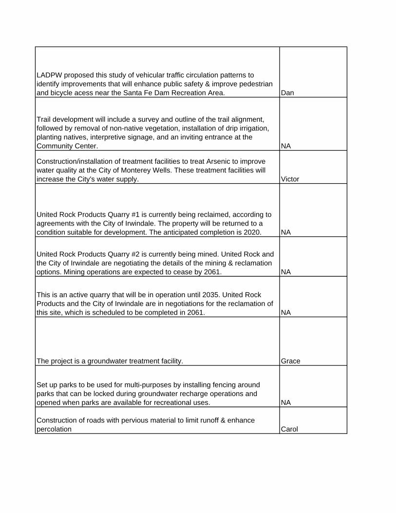
LADPW proposed this study of vehicular traffic circulation patterns to identify improvements that will enhance public safety & improve pedestrian and bicycle acess near the Santa Fe Dam Recreation Area. Dan
Trail development will include a survey and outline of the trail alignment, followed by removal of non-native vegetation, installation of drip irrigation, planting natives, interpretive signage, and an inviting entrance at the Community Center. NA
Construction/installation of treatment facilities to treat Arsenic to improve water quality at the City of Monterey Wells. These treatment facilities will increase the City's water supply. Victor
United Rock Products Quarry #1 is currently being reclaimed, according to agreements with the City of Irwindale. The property will be returned to a condition suitable for development. The anticipated completion is 2020. NA
United Rock Products Quarry #2 is currently being mined. United Rock and the City of Irwindale are negotiating the details of the mining & reclamation options. Mining operations are expected to cease by 2061. NA
This is an active quarry that will be in operation until 2035. United Rock Products and the City of Irwindale are in negotiations for the reclamation of this site, which is scheduled to be completed in 2061. NA
The project is a groundwater treatment facility. Grace
Set up parks to be used for multi-purposes by installing fencing around parks that can be locked during groundwater recharge operations and opened when parks are available for recreational uses. NA
Construction of roads with pervious material to limit runoff & enhance percolation Carol

City of El Monte will improve connections from Mountain View High School & surrounding neighborhoods to the SG River Bike Trail. The project includes entry signage. NA
The project is a groundwater treatment facility Grace
Remove approximately 10,000 cubic yards of accumulated sediment from the Walnut Spreading Basin. NA
Recycled Water Master Plan. Future interconnection with East San Gabriel Valley Regional distribution system. Erik
Construction of smaller recycled water plants placed to enable areas to receive recycled water without installing costly pump stations, etc. Carol
Install curtain wall below well #3 to capture surface water from Rubio Canyon. Drill well to boost stream water to treatment plant. Well provides additional water for Rubio. Wally
New wellhead GW tmt facility & rehab of Pomona's well 32 Jim
New wellhead GW tmt facility & rehab of Pomona's well 37 Jim
New well development Jim
The project is a groundwater treatment facility. Grace
Construct additional groundwater treatment facilities Tony
Project supported by LADPR in development for 6 years, based on a U.S. ACE project options study, the selected option is to build a 25-acre pond, line two lakes to reduce water loss, remove invasive plants, & restore native vegetation. The lakes could be interconnected to Lario Creek & water in the lakes could flow through the system and down to the Rio Hondo Spreading Grounds. NA

Reclaimed water supply to Whittier Narrows Recreation Area, Golf Course, and Legg Lake from Whittier Narrows WRP. Potential extensions to more users and possibly City of Arcadia. John
LADPR believes it is important to preserve these two large lakes as wetlands. The lakes, located at the Nature Center, should be lined to reduce water percolation. NA
The project consists of a 201 acres acquisition and protection and enhancement of two blue-line streams and connected wetlands, sensitive plant communities. A hiking trail is proposed, a small house will be refurbished as a nature center and a habitat/restoration plan would be prepared and implemented with Glendora Community Conservancy. Jane
This project will open a portion of the San Gabriel Canyon Spreading Grounds water conservation facility for public use by creating Zanjero Park. Improvements will include the restoration and expansion and enhancement of an existing watercourse, scenic open space, native landscaping, educational and interpretive signage. The park will serve as a rest stop for hikers, bicyclists and Angeles Forests visitors and as an integral part of planned passive recreational improvements in the area. DanThis project proposes to connect the Central Basin Water Recycling System to serve the cities within the San Gabriel Valley with recycled water. The interconnection will occur in the City of Montebello. Steven
Replace an average of 8,100 AFY imported SWP water with recycled water from San Jose Creek WRP Stage III for groundwater recharge. John
System expansion that will loop the Rio Hondo (Torres) and Century (Ibbetson) systems for flow reliability. StevenConstruction of a surface water treatment plant for the water transmission main from the proposed SGVMWD Raymond Basin Pipeline project to the SGWD, Cities of Alhambra and Monterey Park. This will mitigate gw production impact in the APH. Darin
Construct Pipeline & Pump back facility from Arroyo Seco to Eaton Tony
Increase deliveries of imported water from Metropolitan to reduce drawdown in the Alhambra Pumping Hole (APH). This option may be expensive & would need a feasibility study. Carol

Increase deliveries of imported water from Metropolitan to reduce drawdown in the Alhambra Pumping Hole (APH). This option may be expensive & would need a feasibility study. Carol
Construct additional monitoring wells Tony
Construct additional monitoring wells Tony
Construct additional monitoring wells Tony
Remove paved access roads & replace with bridle paths and trees. Carol
Remove paved access roads & replace with bridle paths and trees. Carol
Installation of a rubber dam above the 10 Freeway to pond water for groundwater recharge. Water levels above the 10 Freeway in the San Gabriel River are low and increasing the water levels will enhance percolation. Within the Main San Gabriel Basin in the City of Irwindale. Tim
Installation of a rubber dam above the 10 Freeway to pond water for groundwater recharge. Water levels above the 10 Freeway in the San Gabriel River are low and increasing the water levels will enhance percolation. Within the Main San Gabriel Basin in the City of Irwindale. Tim
Management revamp of debris basins, create wetlands, provide for wildlife habitat Nancy
Management revamp of debris basins, create wetlands, provide for wildlife habitat. Nancy

Management revamp of debris basins, create wetlands, provide for wildlife habitat Nancy
Phase I currently wholesales approximately 1,000 Acre-feet per year (AFY) of recycled water to San Gabriel Valley Water Company which is the local purveyor supplying Mill Elementary School, Gateway Park Industrial Park, Rio Hondo College, Rose Hills Memorial Park. Tim
Phase I extension will expand the current regional pipeline to a potential carpet mill located in the City of Industry with a potential demand of 600 Acre-feet per year (AFY) of recycled water to this potential customer via the local purveyor of San Gabriel Valley Water Company. Tim
Phase IIA will wholesale recycled water from the Whittier Narrows Water Reclamation Facility owned and operated by the Los Angeles County Sanitation District initially to one customer (Whittier Narrows Recreation Area) in the South El Monte and Whittier Narrows Area. Phase IIA can supply approximately 5,500 Acre-feet per year (AFY) of recycled water and will supply approximately 2,200 AFY during this phase. In addition, the project will conserve about 2,200 AFY of potable water and groundwater by reducing the demand on groundwater and imported water supply for irrigation purposes TimCo st uct o o e te co ect o o o SG s eCanyon-Azusa pipeline to Rialto Feeder or directly to surface water Mike
Construction of new interconnection for WFA from SGVMWD's Devil Canyon-Azusa pipeline to Rialto Feeder or directly to surface water treatment plants. Mike
Extend the SGVMWD pipeline by constructing 14 miles of pipe from current terminus in Azusa into Arcadia, Sierra Madre, and eventually Pasadena. Pipeline will deliver SWP water from SGVMWD or MWD for groundwater recharge and/or groundwater storage. Increased recharge will also increase groundwater levels and water supply reliability in western portion of Main San Gabriel Basin where it meets Raymond Basin at Raymond Fault. Project includes 3 phases: 1 - Provide water to Santa Anita & Sierra Madre Spreading Grounds; 2 - provide water to Eaton Spreading Grounds; and 3 - provide water to Arroyo Seco. Darin

Nine new groundwater production wells in two separate areas (6 wells in Area 1 and 3 wells in Area 2)of Six Basins along with 27,000 feet of pipeline for delivery to local water distribution systems and one 2100gpm Granular Activated Carbon Treatment Plant for the Area 2 wells. Economic and institutional collaboration is expected from local groundwater rights holders in the Six Basins. Again, this project provides addtional synergy to Three Valleys' SASG Multiple Benefits IRWMP Project by essentially maximizing the groundwater storage and production potential of the area, i.e.the SASG project allows greater use of the natural resource of the SASG lands for GW recharge and the wells/treatment/distribution of this project allows extraction without adverse effects. In a broad regional sense, this greatly enhances local water supply reliability and reduces impacts on the imported water system, namely the California-Bay Delta and the State Water Project. Mike
3 of 9 new GW production wells w/ treatment & dist. Pipelines Mike
Spread imported treated H2O at Sierra Madre & Eaton Tony
Spread imported treated H2O at Sierra Madre & Eaton Tony
Construction/installation of treatment facilities to treat perchlorate & VOCs to improve water quality at the City of Monterey Wells and increase City's water supply. Victor
Construction/installation of treatment facilities to treat perchlorate & VOCs to improve water quality at the City of Monterey Wells and increase City's water supply. Victor
Construction/installation of treatment facilities to treat perchlorate & VOCs to improve water quality at the City of Monterey Wells and increase City's water supply. Victor
Installation of synthetic turf on golf courses, parks, schools and businesses to reduce water demands. Turf will allow rainfall to percolate for continued groundwater recharge. Carol

Installation of synthetic turf on golf courses, parks, schools and businesses to reduce water demands. Turf will allow rainfall to percolate for continued groundwater recharge. Carol
Installation of synthetic turf on golf courses, parks, schools and businesses to reduce water demands. Turf will allow rainfall to percolate for continued groundwater recharge. Carol
Installation of synthetic turf on golf courses, parks, schools and businesses to reduce water demands. Turf will allow rainfall to percolate for continued groundwater recharge. Carol
Installation of synthetic turf on golf courses, parks, schools and businesses to reduce water demands. Turf will allow rainfall to percolate for continued groundwater recharge. Carol
Increase amount of water hazards at golf courses for use as percolation basins. Carol
Increase amount of water hazards at golf courses for use as percolation basins. Carol
Increase amount of water hazards at golf courses for use as percolation basins. Carol
Increase amount of water hazards at golf courses for use as percolation basins. Carol
Increase amount of water hazards at golf courses for use as percolation basins. Carol

Increase amount of water hazards at golf courses for use as percolation basins. Carol
Provide a continuous foothills trail from the Arroyo Seco to Eaton Canyon for recreation and preservation of land. The trail exists in pieces; the goal is a continuous 12 mile trail. Nancy
The project will provide a nature center located in Encanto Park. Its location is unique in that it constitutes the transition zone between the nearby San Gabriel Mountains and the urban area above the Main San Gabriel Basin. The project will provide educational materials in the park and along the river, where a trail will lead from the nature center to a viewpoint located on a dike above the river. The park facilities will also include an outdoor classroom, native plant landscaping, and a bioswale designed to treat and release to groundwater the storm runoff that flows from the park. Adaptations to intercept some storm water from adjacent neighborhoods are also being explored. Visitors who experience the educational message of the nature center will be able to directly experience these lessons in a walk along the river. The project is accessible via the Puente Largo Bridge to users of the San Gabriel River bike trail. JeffRemove approximately 200,000 cubic yards of accumulated sediment from Big Dalton Reservoir and place the sediment in Manning Sediment Placement Site in Irwindale. Patricia
Commemorative Oaks is an oak and native plant restoration project in Malibu Creek State Park where volunteers are restoring the oak woodlands that once covered the Las Virgenes Valley. Jo
Phase IIA expansion will wholesale recycled water from the Whittier Narrows Water Reclamation Facility owned and operated by the Los Angeles County Sanitation District initially to two (2) potential customers (Whittier Narrows Golf Course and South El Monte High School) in the South El Monte and Whittier Narrows Area. Phase IIA expansion will supply about 1,200 Acre-feet per year (AFY) of recycled water and will conserve about 1,200 AFY of potable water and groundwater by reducing the demand on groundwater and imported water supply for irrigation purposes Tim

Phase IIB is part of a planned multi-agency recycled water facility expansion. The facility expansion includes the construction of delivery facilities, inter-agency pipelines, pump stations, storage reservoirs and system appurtenances. Phase IIB will expand to the City of Industry, City of West Covina, City of La Puente, Rowland Water District, Suburban Water Systems, Walnut Valley Water District. Tim
Phase III will supply about 2,500 acre-feet per year (AFY) of recycled water to future customers such as Southern California Edison, Caltrans, City of El Monte, City of South El Monte, City of Irwindale and potentially the City of Arcadia. The project will be supplied by the Whittier Narrows Water Reclamation Facility, which is owned and operated by the Los Angeles County Sanitation District via the Phase IIA project. Tim
This project will provide a local water supply for both the Walnut Valley and Rowland Water Districts, both solely dependent on imported water. This will be accomplished through the increased use of local groundwater sources involving extraction, delivery and treatment via in-pipe and reservoir blending. Erik
Map trails, areas to make regional connections,identify and implement creek and trail restoration areas along the blue line stream in La Habra Heights sphere of influence. ValorieAcquisition of San Dimas portion of Wildwood Canyon for habitat & open space. Jane
First sub-phase of implementation of the Concept Plans for the 57 acre park. Phase 1A will include public access by means of a trail connecting the east and west parcels of the project site leading to a river promenade to the San Gabriel River, 14 acres of riparian landscape, a community garden, native plant nursery, a wildflower meadow and a river promenade. Frank
Second sub-phase of the implementation of the Duck Farm Concept plans for the 57 acre park. This phase will build on Phase 1A by providing Permanent park entrance at Proctor Street ;Neighborhood park;150-space parking lot at Proctor Street and 100-space parking lot at Rall Avenue ;Maintenance road improvements Community garden with pedestrian access gate on San Fidel Avenue;Dog park with pedestrian access gate on Ramada Avenue;Expanded riparian corridor;Meandering interior trail;Upland vegetation ; River-edge promenade between Valley Boulevard and farmhouse;Visitor Center (farm house renovation) and amphitheater;Valley Boulevard sidewalk improvements and pedestrian access ramp;Expanded equestrian facility; One-acre freshwater marsh Frank

Implementation of the Concept plans for the southern half of the 57 acre Duck Farm park. Frank
The San Gabriel Valley Riparian Habitat Arundo Removal Project will restore natural riparian habitat and increase surface water flow to the Rio Hondo percolation basins in the San Gabriel Valley. The proposed project will remove 24 net acres of Arundo donax (Arundo or giant reed), which classified federally and by California as a noxious weed. Nancy
Construction of an ion exchange treatment plant for the removal of nitrate adn perchlorate. Dan
Construction of a new groundwater well in the Live Oak Basin. Dan
Construction of drainage improvements in the West fork of Marshall Canyon to improve flood control management and minimize erosion. Dan
The project has identified uses for approximately 17,000 afy of recycled water from the LAGRWP (compared to existing use of 4,000 afy) over 3 phases. The phases are roughly based around five year planning segments such that Phase 1 includes projects that can be on-line in five years or less (by 2012), Phase 2 by 2017, and Phase 3 by 2022. In total, the project increases beneficial use of recycled water from less than 25% (4,000 afy) of LAGWRP production capacity to over 80% (17,000 afy). Phase 1 includes 450 afy, 2,120 afy and 730 afy of non-potable demands for GWP, LADWP and PWP, respectively. Phase 2 includes 2,000 afy of recycled water groundwater recharge (plus 2,000 afy of blend supply) at Arroyo Seco Spreading Grounds. Phase 3 includes 3,000 afy of recycled water groundwater recharge (plus 3,000 afy of blend supply) at Eaton Wash Spreading Grounds. All recycled water will replace the use of imported water from MWD. Rosanna
The basin will be cleaned out and a pump station will be install to drain the facility. The facility will be designed for passive recreation. Ken

Clean out the basin to restore traditional percolation rates, enhance habitat and provide passive recreation. Ken
The Montebello Forebay Advance Water Treatment Facility may utilize tertiary treated recycled water from LACSD’s San Jose Creek WRP and further treated it to offset imported replenishment water demands in the Central Basin. Jason
Community park improvement incorporating capture of run off and transition ot waterconserving landscape FrankThis Emerald Necklace multi-benefit project involves landscaping, restoring and beautifying & adding a water quality and water conservation swale to a critical 1.7 mile segment of land adjacent to the South edge of the Hanson Quarry linking the RH & SGR. This segment continues down the SGR to Ramona Boulevard. This bioswale greening area is 6 acres in total and will include a community habitat park; multi benefit trails including a stabilized decomposed granite path, lighting, access gateways, way finding & interpretive signage, native vegetation & other recreation & exercise amenities. The project will function as part of the part of the Emerald Necklace regional park network to address local and regional water quality, water conservation, open space needs, habitat restoration, and public education. Treatments are based on creating an integrated network of environmentally sensitive and beneficial best management practices throughout the Emerald Necklace System Claire
This Emerald Necklace multi benefit project involves landscaping, restoring, beautifying & adding a water quality and water conservation swale to a critical 2.9 mile segment of land adjacent to the SGR banks from the boundary of El Monte to Azusa. This segment begins where Hanson Aggregates trail meets the SGR in the south & extends north to Angeles Forest in Azusa. This bioswale greening area is 12 acres in total & will include a community habitat park; multi benefit trails of stabilized decomposed granite, lighting, access gateways, way finding & interpretive signage, native vegetation & other recreation & exercise amenities. The project will function as part of the part of the Emerald Necklace Regional Park network to address local & regional water quality, water conservation, open space needs, habitat restoration, and public education. Treatments are based on creating an integrated network of environmentally sensitive and beneficial best management practices throughout the Emerald Necklace System. Claire

The project has identified uses for approximately 17,000 afy of recycled water from the LAGRWP (compared to existing use of 4,000 afy) over 3 phases. The phases are roughly based around five year planning segments such that Phase 1 includes projects that can be on-line in five years or less (by 2012), Phase 2 by 2017, and Phase 3 by 2022. In total, the project increases beneficial use of recycled water from less than 25% (4,000 afy) of LAGWRP production capacity to over 80% (17,000 afy). Phase 1 includes 450 afy, 2,120 afy and 730 afy of non-potable demands for GWP, LADWP and PWP, respectively. All recycled water will replace the use of imported water from MWD. Rosanna
Amigos will provide two 2 month courses called the Youth Green Collar Training Project to offer training in environmental services for 50 at-risk youth ages 16 – 24 in order to initiate workforce development for the Emerald Necklace. The under 25 population in this region totals 119,840, nearly 45% of the population, many of whom are considered “at-risk� because of poverty, unemployment, delinquency, teen pregnancy, and exposure to drugs and gangs. As many as 100 youth will be recruited from the cities of El Monte, South El Monte, Baldwin Park, Irwindale, Rosemead, and East Los Angeles through collaborations with local youth service organizations, local school districts, and our affiliates in the workforce development sector, the Central San Gabriel Valley WorkSource or Career Partners (One-Stop). Recruits will be given an assessment evaluation that will be used to identify 50 participants with the necessary interest level while also determining their basic skill level. Claire
The Overlook project will serve as a key educational focal point for the natural and managed water processes in the area. Its proposed location lies directly on both the San Gabriel River and Lario Creek, and, with its strong links to near and distant open space amenities, the Overlook will allow a closer, more meaningful experience of the San Gabriel River while attracting large numbers of school children to view and learn about this important watershed landscape. As a project related to the overall scheme for the Discovery Center, the Overlook will provide a pivotal connection point for the recreational opportunities of the Center and the bike trail. It will serve an outdoor classroom suitable for complimenting the program of the indoor interpretive center and natural and cultural trails. Claire

Gibson "Mariposa" Park design consists of a large grass play field, playground area for 3 different age appropriate zones, two half-basketball courts, splashpad, several picnic/barbeque areas, parking lot, restrooms, outdoor classroom/amphitheater, interpretive signage (history of the adjacent railroad, Rio Hondo River, and local ecology)native habitat areas, educational kiosk and weather station, butterfly vivarium and a walking and jogging path. The involvement of residents in the planning process has been a wonderful catalyst in fostering community pride and civic involvement and will help ensure the long-term sustainability of the site. The design of the park will facilitate additional learning opportunities in earth science, history, and teamwork. This Park will also be a resource for nearby Rio Vista Elementary and Gidley Elementary/Middle Schools. Claire
This Emerald Necklace multi benefit project includes landscaping, restoring and beautifying & adding a water quality to a critical 4 mile segment of land adjacent to the San Gabriel River and reaching from Ramona Blvd. to Whittier Narrows. This segment of greening area is 20 acres in total and will include a community habitat park; multi benefit trails including a stabilized decomposed granite path, lighting, access gateways, way finding & interpretive signage, native vegetation & other recreation & exercise amenities. The project will function as part of the part of the Emerald Necklace regional park network to address local and regional water quality, water conservation, open space needs, habitat restoration, and public education. Treatments are based on creating an integrated network of environmentally sensitive and beneficial best management practices throughout the Emerald Necklace System Claire
This project will provide an indoor and outdoor interpretive facilities targeted to educate all ages in our region on key watershed issues, while exposing them to the natural setting in Whittier Narrows. This nexus of experiences in and outdoors will strengthen the connection of each person to the natural environment while helping them understand the part they play in protecting and enhancing our water supply and water quality. A constructed wetland will be included for educational and stormwater management uses. Site habitat restoration is a part of the project, through removal of invasives and replacement with indigenous native plants. Trail improvements and connections will be made as well as introduction of the Emerald Necklace and other key natural and recreational locations in the San Gabriel River Watershed. State of the art green building and stormwater/water recharge elements are part of the planned project. Valorie
Study and conceptual design of a multi-purpose corridor along San Jose Creek. Blake

ContactLastname
Drill
Drill
Bolivar
Lilley
Lilley

Bapna
Bapna
Bapna
Lilley
Lilley
Inman
Robinson
Robinson

Jochem
Burgess
Alfonso
NA
NA
Beesley
NA
NA
NA
Zimmer
NA
NA
NA
NA

Alfonso
Burgess
NA
Zampiello
Hall-McGrade
Sovich
Zimmer
Wood
Burgess

Burgess
Burgess
Burgess
Burgess
Burgess
Burgess
Burgess
Burgess
NA
Hansen
Zampiello

NA
NA
Jochem
Jochem
NA

Simpson
NA
NA
NA
Roohk
Burgess
Burgess
Zimmer
NA

Beesley
NA
Robinson
Robinson
Robinson
Robinson
Robinson

NA
Weaver
NA
NA
NA
NA
NA
NA
Williams

Sovich
NA
Sovich
NA
Simpson
Taylor
NA
NA
Sovich
Burgess
Burgess

Burgess
NA
NA
NA
NA
Jochem
NA
NA
Burgess

Simpson
NA
NA
NA
NA
NA

Kasamoto
Shiozawa
NA
Steele
Zimmer
Beesley
Burgess

Bapna
NA
Alfonso
NA
Zimmer
NA
Jochem
NA
NA

NA
NA
NA
Beesley
Alfonso
Lilley
Williams
Meza

Inman
Beesley
Burgess
Burgess
NA
Jochem
Shiozawa
Robinson
NA
Robinson
Taylor
Taylor
Alfonso
Gullo
Gullo
NA
Jochem
NA
Simpson

NA
NA
Beesley
Beesley
Williams
Zimmer
Burgess
Rynn
Rynn

NA
Fuentes
Beesley
Burgess
Burgess
Burgess
Burgess
Burgess
Burgess
Fuentes
Fuentes

NA
NA
Zimmer
Rynn
Wood
Zimmer
NA
Jochem

Wood
Wood
Taylor
Sovich
Williams
Zampiello
Burgess
Jochem
Jochem
Alfonso

Rynn
NA
Meza
NA
NA
NA
Burgess
NA
Williams

NA
Burgess
NA
Hitchman
Williams
Weaver
Taylor
Taylor
Taylor
Burgess
Zampiello
NA

Robinson
NA
Beesley
Rynn
Apodaca
Robinson
Apodaca
Kasamoto
Zampiello
Williams

Williams
Zampiello
Zampiello
Zampiello
Williams
Williams
Jochem
Jochem
Steele
Steele

Steele
Jochem
Jochem
JochemSovich
Sovich
Kasamoto

Sovich
Sovich
Zampiello
Zampiello
Meza
Meza
Meza
Williams

Williams
Williams
Williams
Williams
Williams
Williams
Williams
Williams
Williams

Williams
Steele
Yann
Wood
Kitz
Jochem
Jochem
Jochem
Hitchman
Shatynski
Beesley
Simpson
Simpson

Simpson
Steele
Keesey
Keesey
Keesey
Lau
Zimmer

Zimmer
Weeks
Simpson
Robinson
Robinson

Lau
Robinson
Robinson

Robinson
Robinson
Shatynski
Whittington

Project Prioritization Framework for the Project Prioritization Framework for the Greater Los Angeles County IRWMPGreater Los Angeles County IRWMP
Presentation to the Leadership Committee
October 16, 2008October 16, 2008

Prioritization Framework OverviewPrioritization Framework Overview
Tool to help identify the “best” projects in the Region and in each sub-regionMaintain consistency across RegionAllow sub-regions to emphasize their priorities

Project DatabaseProject Database
Hosted on http://www.lawaterplan.orgInformation entered by project proponents is accessible to all stakeholdersDatabase fields include:
Project DescriptionProject Benefits (quantitative and qualitative)ScheduleCostProponents/PartnersLat/Long


USGR ProjectsUSGR Projects

Prioritization Framework ObjectivesPrioritization Framework Objectives
Provides information as to how each project meets a variety of criteriaProvides a common framework so that results can be compared to results from other sub-regionsProvides sub-regional flexibilityProject information on project readiness but does not require that it be considered in project rankings.

Big Picture: Project Prioritization Big Picture: Project Prioritization ProcessProcess

General Prioritization ApproachGeneral Prioritization Approach
Regional SolutionsRegional Funding PrioritiesRegional and State Political Support
• Local Political Support
• Local Decision-Making
• Local Funding Priority
• Increase Funding Opportunities
• Meet State Priorities
• Addresses multiple IRWMP objectives
• Contribute toward regional targets
• Local preference for IRWMP objectives
• Other factors identified by the sub-region
• Technical Documentation
• Cost and Cost-Share• CEQA• Schedule• Local Support
Regional Objectives
Sub-Regional Priorities
Readiness to Proceed
Best Projectfor the Region.
Helps with:
Best Projectfor the Sub-region.
Helps with:
Best Projectfor Present Funding
Helps with:
Same for all sub-regions
Different for all sub-regions
Same for all sub-regions

Project Examples To Demonstrate the Project Examples To Demonstrate the FrameworkFramework
Project 1 – Large single-purpose water supply project Completed all design, permitting and environmental clearance and is ready for construction.
Project 2 – Moderate-sized recycled water projectBenefit to a local disadvantaged communityCovers more than one sub-region or includes multiple partners. Conceptual and preliminary plans have been completed while land acquisition, permitting and final design are in process.
Project 3 – Small open-space and recreation projectSome habitat benefit but is not designed to enhance water quality or water supply. Located only in one sub-region or only has one proponent,Does not produce a benefit for a disadvantage communityNot considered a high profile or demonstration projectMost planning and design work has been completed but no information is available on final construction documents.
Project 4 – Multi-objective project water quality improvement projectAlso produces quantifiable benefits for water supply, habitat, open space and recreation and also replaces or refurbishes existing infrastructure. High profile or demonstration projectLocated in one sub-region or only includes one proponentNo information is available regarding planning, design, or permitting.

Table 4: Example of Regional Table 4: Example of Regional Prioritization Evaluation and ScoringPrioritization Evaluation and Scoring

Table 5: Example of SubTable 5: Example of Sub--Regional Regional Prioritization Evaluation and ScoringPrioritization Evaluation and Scoring

Table 6: Example of Readiness to Proceed Table 6: Example of Readiness to Proceed Prioritization Evaluation & ScoringPrioritization Evaluation & Scoring

Summary of Prioritization FrameworkSummary of Prioritization Framework
Scores each project in 3 categories:Regional Priorities (Quantitative Benefits)Sub-Regional Priorities (Qualitative Benefits)Readiness to Proceed
Each category has 100 total possible points (USGR used a lower point total)For Sub-Regional Priorities, objectives are ranked by each SC and given a weight associated with the ranking (1 to 5).Category scores can be combined or used separately as appropriate for a particular funding opportunity.

USGR SubUSGR Sub--Regional Ranked Objectives Regional Ranked Objectives
1. Improve Water Supply (8 pts)2. Improve Water Quality (7 pts)3. Enhance Habitat (6 pts)4. Enhance Open Space/Recreation (5 pts)5. Sustain Communities (4 pts)
Other Sub-Regional PrioritiesCritical Needs (4 pts)Disadvantaged Communities (4 pts)Conjunctive Use (4 pts)Recycled Water (4 pts)Conservation (4 pts)

Next StepsNext Steps
Update project information (proponents notified)Essential to have project on IRWMP list for Prop 84 fundingProponent to modify Project Database (inactive vs active, DAC, new info, etc.)
Value of using last sub-regional workshop to reprioritize?
Obtain agreement on how prioritization tools will be applied and a schedule
Pursue 2 DAC opportunities for project integration (e.g. S. El Monte conservation)

Project ID Project Submitter Project Title
Lower Estimated
Total Capital Cost
Upper Estimated
Total Capital Cost
Regional
ScoreRegional Rank
Sub-regional Score
Sub-regional
Rank
Regional + Sub-
regional Score
Regional + Sub-
regional Rank
Readiness to Proceed
Score
Readiness to Proceed
Rank
348
Three Valleys Municipal Water District
San Antonio Spreading Grounds: Habitat/Recreation Enhancement 32,000,000$ 44,000,000$ 29 1 32 4 61 1 19 11
369
Upper San Gabriel Valley Municipal Water District
San Gabriel Valley Water Recycling Project (Phase IIA - Expansion) 3,500,000$ 5,000,000$ 16 4 40 1 56 2 28 4
368
Upper San Gabriel Valley Municipal Water District
San Gabriel Valley Water Recycling Project (Phase IIA - Existing) 6,000,000$ 6,500,000$ 16 4 40 1 56 2 27 5
370
Upper San Gabriel Valley Municipal Water District
San Gabriel Valley Water Recycling Project (Phase IIB - New) 13,000,000$ 20,000,000$ 16 4 40 1 56 2 24 7
275
San Gabriel & Lower Los Angeles Rivers & Mountains Conservancy, Amigos de L
Emerald Necklace Segment D:San Gabriel River to Walnut Creek 1,800,000$ 4,800,000$ 15 5 40 1 55 3 22 8
365
Upper San Gabriel Valley Municipal Water District
Covina Irrigating Co. Surface Water Treatment Plant Improvements 1,000,000$ 3,000,000$ 17 3 36 2 53 4 32 2
272
San Gabriel & Lower Los Angeles Rivers & Mountains Conservancy, Amigos de L
Emerald Necklace Segment A:Alhambra Wash to Eaton Wash 1,800,000$ 4,000,000$ 13 7 40 1 53 4 31 3
273
San Gabriel & Lower Los Angeles Rivers & Mountains Conservancy, Amigos de L
Emerald Necklace Segment B:Eaton Wash to S. Edge of Peck Pk 5,270,124$ 5,797,136$ 13 7 40 1 53 4 31 3
USGR&RH Project ScoresSeptember 25, 2007

Project ID Project Submitter Project Title
Lower Estimated
Total Capital Cost
Upper Estimated
Total Capital Cost
Regional
ScoreRegional Rank
Sub-regional Score
Sub-regional
Rank
Regional + Sub-
regional Score
Regional + Sub-
regional Rank
Readiness to Proceed
Score
Readiness to Proceed
Rank
274
San Gabriel & Lower Los Angeles Rivers & Mountains Conservancy, Amigos de L
Emerald Necklace Segment C: Peck Rd Water Conserv. Pk to SGR 1,300,000$ 3,600,000$ 13 7 40 1 53 4 31 3
366
Upper San Gabriel Valley Municipal Water District
San Gabriel Valley Water Recycling Project (Phase I -Existing) 3,200,000$ 3,500,000$ 12 8 40 1 52 5 33 1
636
Amigos de Los RiosLos Angeles, RMc
Alhambra Wash Naturalization Implementation 4,200,000$ 6,200,000$ 12 8 40 1 52 5 19 11
156
Friends of the Los Angeles Chap. Found., City of El Monte, Amigos de los Ri
Peck Water Conservation Park 120,000$ 300,000$ 12 8 40 1 52 5 13 16
10965
Amigos de Los Rios/Emerald Necklace Coalition
Emerald Necklace-Segment E: Ramona Blvd to Whittier Narrows 1,300,000$ 3,600,000$ 11 9 40 1 51 6 31 3
10981 Amigos de los Rios
Emerald Necklace-Segment F: Whittier Narrows to South of Pico Rivera Sprea 1,300,000$ 3,600,000$ 11 9 40 1 51 6 31 3
371
Upper San Gabriel Valley Municipal Water District
San Gabriel Valley Water Recycling Project (Phase III - Future) 20,000,000$ 25,000,000$ 10 10 40 1 50 7 11 18
417
Watershed Conservation Authority, RMC Duck Farm Phase 1A 4,600,000$ 5,800,000$ 11 9 36 2 47 8 22 8
535LASGR Watershed Council
Watershed Education for Elected/Appointed Officials -$ -$ 5 14 40 1 45 9 15 14
10788 Amigos de los RiosGreen Collar Youth Training Program -$ -$ 5 14 40 1 45 9 10 19
10749
Amigos de Los Rios/Emerald Necklace Coalition
Emerald Necklace Vision Plan II 100,000$ 350,000$ 5 14 40 1 45 9 6 22

Project ID Project Submitter Project Title
Lower Estimated
Total Capital Cost
Upper Estimated
Total Capital Cost
Regional
ScoreRegional Rank
Sub-regional Score
Sub-regional
Rank
Regional + Sub-
regional Score
Regional + Sub-
regional Rank
Readiness to Proceed
Score
Readiness to Proceed
Rank
11195 Amigos de los Rios
Emerald Necklace Innovative Forestry Program- Tree Planting Campaign (1)$ (1)$ 5 14 40 1 45 9 6 22
1219
Three Valleys Municipal Water District & Six Basins Water Master
Six Basin Comprehensive Groundwater Improvement Project 10,000,000$ 30,000,000$ 14 6 28 5 42 10 14 15
339
SGVMWD, Cities of Alhambra and Sierra Madre
SGVMWD - Raymond Basin Feeder 15,000,000$ 25,000,000$ 10 10 32 4 42 10 13 16
387
Water purveyors in the Raymond & Main San Gabriel Basin Alosta Connection 1,000,000$ 2,000,000$ 6 13 36 2 42 10 9 20
367
Upper San Gabriel Valley Municipal Water District
San Gabriel Valley Water Recycling Project (Phase I - Extension) 2,000,000$ 2,200,000$ 6 13 35 3 41 11 21 9
10866 Amigos de los RiosGibson Mariposa Multi-Benefit Park 1,500,000$ 3,800,000$ 5 14 36 2 41 11 20 10
190Los Angeles County Flood Control District
Irwindale Spreading Grounds and Manning Pit - Interconnecting Drain and Bas 900,000$ 1,500,000$ 18 2 23 7 41 11 18 12
418
Watershed Conservation Authority, RMC Duck Farm Phase 1B 5 14 36 2 41 11 18 12
58City of Duarte/Karen Herrera Encanto Nature Walk 350,000$ 450,000$ 5 14 36 2 41 11 17 13
537LASGR Watershed Council Online Watershed Primer 250,000$ 350,000$ 5 14 36 2 41 11 14 15
192Los Angeles County Flood Control District
Live Oak Spreading Grounds Intake Improvements 3,000,000$ 5,000,000$ 8 12 32 4 40 12 6 22
60City of El Monte & Amigos de Los Rios
El Monte Storm Drain Daylighting/Green Infrastructure 5,000,000$ 6,000,000$ 0 17 40 1 40 12 5 23
177Los Angeles County Flood Control District
Santa Anita Dam Seismic Rehabilitation 12,775,000$ 72,800,000$ 17 3 23 7 40 12 5 23
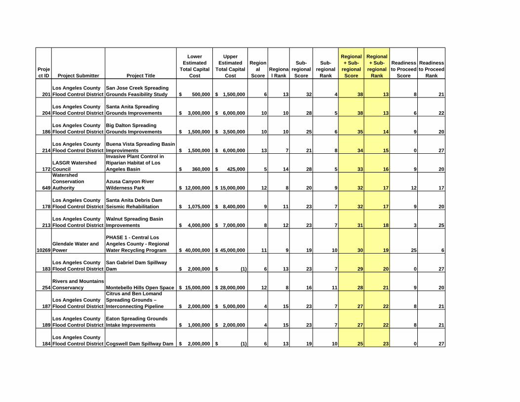
Project ID Project Submitter Project Title
Lower Estimated
Total Capital Cost
Upper Estimated
Total Capital Cost
Regional
ScoreRegional Rank
Sub-regional Score
Sub-regional
Rank
Regional + Sub-
regional Score
Regional + Sub-
regional Rank
Readiness to Proceed
Score
Readiness to Proceed
Rank
201Los Angeles County Flood Control District
San Jose Creek Spreading Grounds Feasibility Study 500,000$ 1,500,000$ 6 13 32 4 38 13 8 21
204Los Angeles County Flood Control District
Santa Anita Spreading Grounds Improvements 3,000,000$ 6,000,000$ 10 10 28 5 38 13 6 22
186Los Angeles County Flood Control District
Big Dalton Spreading Grounds Improvements 1,500,000$ 3,500,000$ 10 10 25 6 35 14 9 20
214Los Angeles County Flood Control District
Buena Vista Spreading Basin Improviments 1,500,000$ 6,000,000$ 13 7 21 8 34 15 0 27
172LASGR Watershed Council
Invasive Plant Control in Riparian Habitat of Los Angeles Basin 360,000$ 425,000$ 5 14 28 5 33 16 9 20
649
Watershed Conservation Authority
Azusa Canyon River Wilderness Park 12,000,000$ 15,000,000$ 12 8 20 9 32 17 12 17
178Los Angeles County Flood Control District
Santa Anita Debris Dam Seismic Rehabilitation 1,075,000$ 8,400,000$ 9 11 23 7 32 17 9 20
213Los Angeles County Flood Control District
Walnut Spreading Basin Improvements 4,000,000$ 7,000,000$ 8 12 23 7 31 18 3 25
10269Glendale Water and Power
PHASE 1 - Central Los Angeles County - Regional Water Recycling Program 40,000,000$ 45,000,000$ 11 9 19 10 30 19 25 6
183Los Angeles County Flood Control District
San Gabriel Dam Spillway Dam 2,000,000$ (1)$ 6 13 23 7 29 20 0 27
254Rivers and Mountains Conservancy Montebello Hills Open Space 15,000,000$ 28,000,000$ 12 8 16 11 28 21 9 20
187Los Angeles County Flood Control District
Citrus and Ben Lomand Spreading Grounds – Interconnecting Pipeline 2,000,000$ 5,000,000$ 4 15 23 7 27 22 8 21
189Los Angeles County Flood Control District
Eaton Spreading Grounds Intake Improvements 1,000,000$ 2,000,000$ 4 15 23 7 27 22 8 21
184Los Angeles County Flood Control District Cogswell Dam Spillway Dam 2,000,000$ (1)$ 6 13 19 10 25 23 0 27

Project ID Project Submitter Project Title
Lower Estimated
Total Capital Cost
Upper Estimated
Total Capital Cost
Regional
ScoreRegional Rank
Sub-regional Score
Sub-regional
Rank
Regional + Sub-
regional Score
Regional + Sub-
regional Rank
Readiness to Proceed
Score
Readiness to Proceed
Rank
24
Central Basin Municipal Water District
Central Basin MWD / SGVMWD Interconnection 10,000,000$ -$ 9 11 12 13 21 24 8 21
123City of Sierra Madre & other water systems Additional Interconnections 100,000$ 1,000,000$ 0 17 20 9 20 25 3 25
241
Puente Hills Landfill Native Habitat Preservation, RMC
Puente Hills and Whittier Narrows Habitat Connection 8,000,000$ 15,000,000$ 6 13 13 12 19 26 1 26
191Los Angeles County Flood Control District
LACDA Project - Stormwater Management Plan 100,000$ 1,000,000$ 5 14 12 13 17 27 6 22
536LASGR Watershed Council
Historic Aerial Photography Preservation 195,000$ 215,000$ 11 9 4 15 15 28 20 10
237
Puente Hills Landfill Native Habitat Preservation Puente Hills Wildlife Corridor 20,000,000$ 30,000,000$ 6 13 9 14 15 28 3 25
10832 Amigos de los RiosSan Gabriel River Discovery Center Overlook (1)$ (1)$ 5 14 9 14 14 29 9 20
37 City of Azusa, RMC Roberts Creek Trail Access -$ -$ 4 15 9 14 13 30 1 26
235Producers pumping from the APH
Develop Wellfield/Pipeline outside the APH 1,000,000$ 10,000,000$ 0 17 12 13 12 31 3 25
246Raymond Basin Management Board
Raymond Basin Monitoring Wells Location 1 1,000,000$ 10,000,000$ 0 17 12 13 12 31 3 25
247Raymond Basin Management Board
Raymond Basin Monitoring Wells Location 2 1,000,000$ 10,000,000$ 0 17 12 13 12 31 3 25
248Raymond Basin Management Board
Raymond Basin Monitoring Wells Location 3 1,000,000$ 10,000,000$ 0 17 12 13 12 31 3 25
355 TVMWD and WFASGVMWD - Metropolitan Interconnection 1 (Upland) 1,000,000$ 10,000,000$ 0 17 12 13 12 31 3 25
356 TVMWD and WFA
SGVMWD - Metropolitan Interconnection 2 (Rancho Cucamonga) 1,000,000$ 10,000,000$ 0 17 12 13 12 31 3 25

Project ID Project Submitter Project Title
Lower Estimated
Total Capital Cost
Upper Estimated
Total Capital Cost
Regional
ScoreRegional Rank
Sub-regional Score
Sub-regional
Rank
Regional + Sub-
regional Score
Regional + Sub-
regional Rank
Readiness to Proceed
Score
Readiness to Proceed
Rank
175 Los Angeles CountyAltadena Crest Trail Restoration 764,495$ 1,000,000$ 11 9 0 16 11 32 12 17
46 City of Covina
Charter Oak Wash Open Channel & Streambed Betterments within Kahler Russel 100,000$ 1,000,000$ 6 13 0 16 6 33 10 19
227
North East Trees/Los Anegles County Flood Control District, RMC
Lario Creek Stream Corridor Restoration Plan (Lario Creek/Zone 1 Ditch) 1,000,000$ 10,000,000$ 6 13 0 16 6 33 10 19
382USGVMWD and SGVMWD
San Gabriel Valley Recycled Water Demonstration Project -$ -$ 6 13 0 16 6 33 9 20
380 USGVMWD
Rubber Dam Below Santa Fe Dam (San Gabriel River Storm Water Storage Proj1 1,000,000$ 3,000,000$ 6 13 0 16 6 33 4 24
385Walnut Valley W.D., Rowland W.D.
The Southeast San Gabriel Valley Groundwater Supply Project 8,200,000$ 6 13 0 16 6 33 4 24
194Los Angeles County Flood Control District Puddingstone Wetland 1,000,000$ 10,000,000$ 6 13 0 16 6 33 3 25
202Los Angeles County Flood Control District
San Jose Creek TMDL Project Concept 1,000,000$ 10,000,000$ 6 13 0 16 6 33 3 25
381 USGVMWD
Rubber Dam Below Santa Fe Dam (San Gabriel River Storm Water Storage Proj2 1,000,000$ 10,000,000$ 6 13 0 16 6 33 3 25
297
San Gabriel Basin Water Quality Authority
San Gabriel Valley Water Company Plant B5 10,000,000$ -$ 6 13 0 16 6 33 1 26
298
San Gabriel Basin Water Quality Authority
San Gabriel Valley Water Company Plant B6 10,000,000$ -$ 6 13 0 16 6 33 1 26
383USGVMWD, RMC, Sierra Club
Quarry Reclamation/Water Storage/Recreational Facilities Development Study 8,000,000$ 15,000,000$ 6 13 0 16 6 33 0 27
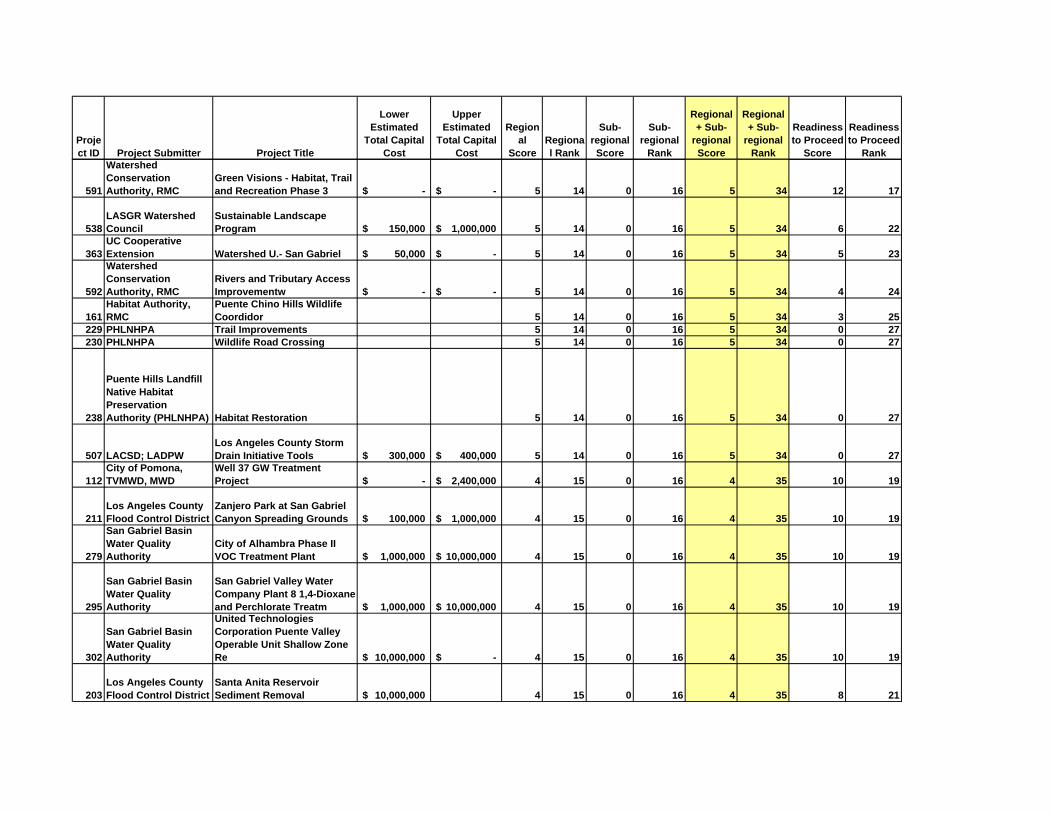
Project ID Project Submitter Project Title
Lower Estimated
Total Capital Cost
Upper Estimated
Total Capital Cost
Regional
ScoreRegional Rank
Sub-regional Score
Sub-regional
Rank
Regional + Sub-
regional Score
Regional + Sub-
regional Rank
Readiness to Proceed
Score
Readiness to Proceed
Rank
591
Watershed Conservation Authority, RMC
Green Visions - Habitat, Trail and Recreation Phase 3 -$ -$ 5 14 0 16 5 34 12 17
538LASGR Watershed Council
Sustainable Landscape Program 150,000$ 1,000,000$ 5 14 0 16 5 34 6 22
363UC Cooperative Extension Watershed U.- San Gabriel 50,000$ -$ 5 14 0 16 5 34 5 23
592
Watershed Conservation Authority, RMC
Rivers and Tributary Access Improvementw -$ -$ 5 14 0 16 5 34 4 24
161Habitat Authority, RMC
Puente Chino Hills Wildlife Coordidor 5 14 0 16 5 34 3 25
229 PHLNHPA Trail Improvements 5 14 0 16 5 34 0 27230 PHLNHPA Wildlife Road Crossing 5 14 0 16 5 34 0 27
238
Puente Hills Landfill Native Habitat Preservation Authority (PHLNHPA) Habitat Restoration 5 14 0 16 5 34 0 27
507 LACSD; LADPWLos Angeles County Storm Drain Initiative Tools 300,000$ 400,000$ 5 14 0 16 5 34 0 27
112City of Pomona, TVMWD, MWD
Well 37 GW Treatment Project -$ 2,400,000$ 4 15 0 16 4 35 10 19
211Los Angeles County Flood Control District
Zanjero Park at San Gabriel Canyon Spreading Grounds 100,000$ 1,000,000$ 4 15 0 16 4 35 10 19
279
San Gabriel Basin Water Quality Authority
City of Alhambra Phase II VOC Treatment Plant 1,000,000$ 10,000,000$ 4 15 0 16 4 35 10 19
295
San Gabriel Basin Water Quality Authority
San Gabriel Valley Water Company Plant 8 1,4-Dioxane and Perchlorate Treatm 1,000,000$ 10,000,000$ 4 15 0 16 4 35 10 19
302
San Gabriel Basin Water Quality Authority
United Technologies Corporation Puente Valley Operable Unit Shallow Zone Re 10,000,000$ -$ 4 15 0 16 4 35 10 19
203Los Angeles County Flood Control District
Santa Anita Reservoir Sediment Removal 10,000,000$ 4 15 0 16 4 35 8 21

Project ID Project Submitter Project Title
Lower Estimated
Total Capital Cost
Upper Estimated
Total Capital Cost
Regional
ScoreRegional Rank
Sub-regional Score
Sub-regional
Rank
Regional + Sub-
regional Score
Regional + Sub-
regional Rank
Readiness to Proceed
Score
Readiness to Proceed
Rank
210Los Angeles County Flood Control District
Walnut Spreading Basin Cleanout 100,000$ 1,000,000$ 4 15 0 16 4 35 8 21
51 City of Diamond BarSycamore Canyon Trail Phase III and IV 100,000$ 1,000,000$ 4 15 0 16 4 35 6 22
212Los Angeles County Flood Control District
Big Dalton Reservoir Sediment Removal 1,000,000$ 10,000,000$ 4 15 0 16 4 35 6 22
78 City of La Verne Live Oak GW Well (1)$ (1)$ 4 15 0 16 4 35 5 23
110City of Pomona, TVMWD
Well 32 GW Treatment Project -$ 1,070,000$ 4 15 0 16 4 35 4 24
216
Los Angeles County Flood Control District, RMC Morris Dam Peninsula Park 1,000,000$ 10,000,000$ 4 15 0 16 4 35 4 24
353TVMWD & Six Basins Watermaster
Six Basin Comprehensive Groundwater Improvement Project Phase 1 -$ 14,000,000$ 4 15 0 16 4 35 4 24
354TVMWD & Six Basins Watermaster
Six Basin Comprehensive Groundwater Improvement Project Phase 2 -$ 10,000,000$ 4 15 0 16 4 35 4 24
359
TVMWD, MWD, & Golden State Water Co.
Foothill Basin Conjunctive Use Project -$ 1,500,000$ 4 15 0 16 4 35 4 24
360TVMWD, USGVMWD, Covina Irrigating Co.
CIC Surface and GW Treatment Project -$ 5,000,000$ 4 15 0 16 4 35 4 24
361
TVMWD, Walnut Valley W.D., Rowland W.D.
Fulton Plant GW Treatment Project -$ 4,000,000$ 4 15 0 16 4 35 4 24
281
San Gabriel Basin Water Quality Authority
City of Monterey Park Fern Well 100,000$ 1,000,000$ 4 15 0 16 4 35 1 26
283
San Gabriel Basin Water Quality Authority
City of Monterey Park Well 5 & Well 6 VOC Expansion & Perchlorate Treatment 1,000,000$ 10,000,000$ 4 15 0 16 4 35 1 26

Project ID Project Submitter Project Title
Lower Estimated
Total Capital Cost
Upper Estimated
Total Capital Cost
Regional
ScoreRegional Rank
Sub-regional Score
Sub-regional
Rank
Regional + Sub-
regional Score
Regional + Sub-
regional Rank
Readiness to Proceed
Score
Readiness to Proceed
Rank
287
San Gabriel Basin Water Quality Authority
Golden State Water Company Encinita VOC Treatment Plant 1,000,000$ 10,000,000$ 4 15 0 16 4 35 1 26
288
San Gabriel Basin Water Quality Authority
Golden State Water Company Wells SG1 and SG2 Perchlorate Treatment Facility 1,000,000$ 10,000,000$ 4 15 0 16 4 35 1 26
292
San Gabriel Basin Water Quality Authority
Northrop Grumman Puente Valley Operable Unit Intermediate Zone Remedy 10,000,000$ -$ 4 15 0 16 4 35 1 26
285
San Gabriel Basin Water Quality Authority
East Side Performing Settling Defendants and City of El Monte East Side Dee 1,000,000$ 10,000,000$ 2 16 0 16 2 36 10 19
286
San Gabriel Basin Water Quality Authority
East Side Performing Settling Defendants East Side Shallow Remedy 1,000,000$ 10,000,000$ 2 16 0 16 2 36 10 19
290
San Gabriel Basin Water Quality Authority Hermetic Seal Site Extraction 100,000$ 1,000,000$ 2 16 0 16 2 36 10 19
293
San Gabriel Basin Water Quality Authority
Northrop Grumman S11 & S12 Shallow Zone Extraction 10,000,000$ -$ 2 16 0 16 2 36 10 19
378 USGVMWD Synthetic Turf Athletic Fields 1,000,000$ 5,000,000$ 2 16 0 16 2 36 9 20
277
San Gabriel Basin Water Quality Authority
Amarillo Mutual Water Company VOC Treatment Plant 100,000$ 1,000,000$ 2 16 0 16 2 36 4 24
304
San Gabriel Basin Water Quality Authority
West Side Performing Settling Defendants West Side Shallow Remedy 1,000,000$ 10,000,000$ 2 16 0 16 2 36 1 26

2
projects into the database must list their entity as the project proponent and can list other collaborators as project partners.
• The prioritization framework was a tool developed to prioritize the project list and can be adjusted as appropriate. The framework targeted Prop 50 guidelines, but Prop 84 may have other criteria.
• November 15th will be the deadline for updating the database before projects are re-prioritized.
• The database includes projects from early in the process that are just concepts and ideas entered into the database using a short form. There are therefore projects in the database that have not been developed and are missing data in some fields.
• SB X21 allocates 10% of the money to DACs. Therefore, efforts are being undertaken to identify DAC projects.
• When IRWMP was adopted in Dec 2006, it included specific goals for the Region. All of the projects in the database are intended to meet the adopted goals within a 20-year timeframe. In theory, projects meeting more goals of the IRWMP will score higher.
• LA County includes 3 IRWMP Regions: Antelope Valley, Upper Santa Clara, and Greater LA County). Within the Greater LA County IRWMP, there are 5 watershed-based sub-regions.
• Under the IRWMP component of Prop 84, projects are required to have multiple benefits
• Project proponents can search the database by keyword or geographically to see if other project proponents have similar idea or another idea for the same space. The SC periodically reviews the project list to identify duplicate projects and integration opportunities.
• For IRWMP grants, the State gives one grant to the Region, administered by the LA County Flood Control District. Individual agreements between the County and project proponents are then developed.
• The purpose of the prioritization process is to provide a framework for discussion about which projects provide most benefits for the amount of funding available.
• The SC can use the second sub –regional workshop to redo the project prioritization based on the updated projects and the work the SC did at the last workshop on identifying inactive and duplicate projects.
• Prop 84 earmarked $215M for this funding area, but the current $100M in IRWMP funding will be allocated through a competitive funding process. Any funding received from the $100M will come out of the funding area pot. Since there is no agreement within the funding area on the split between the 3 Regions of the $215M, the Region has to apply for the

3
$100M because there is no guarantee that the Region will get its fair share of the $215M.
• The Region also need to consider the cost of applying for the $100 million in IRWMP funds.
• Regardless of the cost of applying, the Region needs to apply for political reasons.
• South Bay Steering Committee will be recommending that the Region apply for funding for a Regional conservation program. West Basin is going to suggest this at the Leadership Committee.
• In the $100 million, 20% of funding is designated to go to conservation to address the 20% reduction by 2020 proposed by the Governor. The Region should attempt to target that money.
• The Region should apply for funding for a regional conservation project in order to show the State that all of the sub-regions are working together. An organization that overlies all of the sub-regions, such as LA County of Metropolitan Water District, will need to take the lead on this project. A project proponent will need to enter the project into the database so that it becomes part of the IRWMP.
• The Region could also consider a Regional project for TMDLs, as these are being regulated region-wide and have a looming deadline. However, in the past state grants have called out that if a grant is to fund a program to satisfy a permit, it is not eligible.
• The Region could also consider a project that could be implemented quickly, such as an educational program or ET controller program.
• The Region could also target the $20 million in DAC funding that will be available from Prop 84.
• Ideas for a regional program for a Prop 84 application should be an agenda item at the LC.
• The Regional conservation project would just be one of the projects that the Region would apply for, in addition to other projects from the prioritized project list.
• The State and Roundtable of Regions have a workshop on Nov. 12th. However, it is unlikely that draft guidelines will be released before the end of the year.
• The COG will consider having some appointees from their committee to the SC. The consultant will send a copy of meeting dates to Bekah and MaryAnn. MaryAnn will verify that the projects on their list are in the database and will pass on the notice regarding November 15th update deadline to appropriate stakeholders..

4
• The SC will review of sub-regional ranked objectives used in last year’s prioritization exercise at the November 20th meeting.
• Prop 84 has two components, climate change and flood protection, that were not included in Prop 50 and therefore were not incorporated in the prioritization framework. The framework may need to be adjusted to account for these.
• A sub-regional prioritization workshop will be held on December 18th from 10 am to 4 pm.
• SB XX1 does not require an immediate update of the IRWMP to apply for funding. If an application is funded, the Region is required to update its Plan within 2 years of the time funding is awarded. The Region will need to update and vote on an update to the project list in the near term because any project included in the application must be included in the Plan.
At the direction of the SC, the consultant will:
• E-mail the SGVCOG instructions on how to enter projects into the lawaterplan.org database.
• Notify stakeholders of the November 15th deadline for updating projects.
• E-mail the project map and project descriptions to stakeholders.
• Investigate whether projects to satisfy TMDLs are eligible for IRWMP funding.
• Re-score both sub-regional and regional projects for the December workshop after November 15th.
• Add MaryAnn Lutz and Bekah Cooke to the SC distribution list. 4. DAC Outreach The consultant has attempted to contact South El Monte regarding an irrigation project but has not received a response. The SC voted to have the consultant contact the City of Duarte to discuss pursuing an irrigation project there. 5. Leadership Committee - Discuss draft agenda items and provide direction to
Chair The draft LC agenda was not available. The SC provided direction to the Chair on regional projects for a Prop 84 application during discussion of Item 3. 6. Future meeting schedule

5
a. Leadership Committee, October 22, 2008, 9:30 am to 12:00 pm, LACFCD, 12th Floor
b. Upper San Gabriel River and Rio Hondo Steering Committee, November 18, 2008, 1:30 pm to 3:30 pm – San Gabriel Basin Water Quality Authority
c. Upper San Gabriel River and Rio Hondo Sub-Regional Workshop, December 18, 2008, 10:00 pm to 4:00 pm - San Gabriel Basin Water Quality Authority