1.0 RI Addendum Scope of Work - National Grid:Fulton
12
Donald Campbell Project Manager 287 Maspeth Avenue, Brooklyn, NY 11211 T: 718.963.5453 ■ F: 718.963.5611 ■ [email protected] ■ www.nationalgrid.com February 2, 2011 Henry Willems Environmental Engineer New York State Department of Environmental Conservation 625 Broadway Albany, New York 12233-7014 Re: Revised Final Remedial Investigation Work Plan Addendum No. 2 Fulton Municipal Works Former Manufactured Gas Plant (MGP) Site Brooklyn, New York Site No. 224051/Index No. A2-0552-0606 Dear Mr. Willems: National Grid is submitting the following Revised Final Remedial Investigation (RI) Work Plan Addendum No. 2 to conduct RI field activities within public street rights-of-way (ROWs) and at two private properties in the vicinity of the Fulton Municipal Works former Manufactured Gas Plant (MGP) site in Brooklyn, New York (Site). National Grid prepared this work plan in response to your July 16, 2010 letter which requested the installation of deep borings to evaluate the off-site lateral extent of dense non-aqueous phase liquid (DNAPL) tar and the installation of shallow and intermediate monitoring well pairs to evaluate the groundwater conditions to the west and southwest of the Site in the vicinity of the Gowanus Canal. The Final RI Work Plan Addendum No. 2 was updated based upon comments provided by New York State Department of Environmental Conservation (DEC) in a letter dated October 4, 2010. DEC conditionally approved the Final RI Work Plan Addendum No. 2 in a letter dated November 5, 2010 (with additional clarification in an email dated December 7, 2010), provided that one soil boring and a shallow and intermediate well pair be installed at the head of the Gowanus Canal, approximately 180 feet to the north of RI monitoring well FW-MW-10, on the property at 226 Nevins Street. In addition to the requested shallow and intermediate well pair, National Grid will also install a deep monitoring well pair, at 226 Nevins Street, that will be screened above and below the Gardiners Clay in order to evaluate the groundwater conditions adjacent to the Gowanus Canal. 1.0 RI Addendum Scope of Work National Grid and our contractors have completed the RI sampling activities that were proposed as part of the DEC and New York State Department of Health (DOH)-approved RI Work Plan entitled Final Remedial Investigation Work Plan Fulton Municipal Works, Former Manufactured Gas Plan Site, Brooklyn, New York ACO Index No. A2-0552-0606, Site # 224051 dated March 2008 (Final RI Work Plan) and Remedial Investigation Work Plan Addendum dated July 20, 2009. Between June and August 2010, National Grid completed additional sampling activities, within the Site RI study area, that were provided in the Revised Monitoring Well Installation Work Plan, Gowanus Canal Superfund Site, Brooklyn, New York, EPA ID# NYN000206222 dated June 2010. This Revised Final RI Work Plan Addendum No. 2 proposes the installation of eight deep soil borings, three shallow and intermediate monitoring well pairs and one deep monitoring well pair. The locations of the proposed soil borings and monitoring wells are provided in Figure 1.
Transcript of 1.0 RI Addendum Scope of Work - National Grid:Fulton

Donald Campbell Project Manager
287 Maspeth Avenue, Brooklyn, NY 11211 T: 718.963.5453 ■ F: 718.963.5611 ■ [email protected] ■ www.nationalgrid.com
February 2, 2011 Henry Willems Environmental Engineer New York State Department of Environmental Conservation 625 Broadway Albany, New York 12233-7014 Re: Revised Final Remedial Investigation Work Plan Addendum No. 2 Fulton Municipal Works Former Manufactured Gas Plant (MGP) Site Brooklyn, New York Site No. 224051/Index No. A2-0552-0606
Dear Mr. Willems: National Grid is submitting the following Revised Final Remedial Investigation (RI) Work Plan Addendum No. 2 to conduct RI field activities within public street rights-of-way (ROWs) and at two private properties in the vicinity of the Fulton Municipal Works former Manufactured Gas Plant (MGP) site in Brooklyn, New York (Site). National Grid prepared this work plan in response to your July 16, 2010 letter which requested the installation of deep borings to evaluate the off-site lateral extent of dense non-aqueous phase liquid (DNAPL) tar and the installation of shallow and intermediate monitoring well pairs to evaluate the groundwater conditions to the west and southwest of the Site in the vicinity of the Gowanus Canal. The Final RI Work Plan Addendum No. 2 was updated based upon comments provided by New York State Department of Environmental Conservation (DEC) in a letter dated October 4, 2010. DEC conditionally approved the Final RI Work Plan Addendum No. 2 in a letter dated November 5, 2010 (with additional clarification in an email dated December 7, 2010), provided that one soil boring and a shallow and intermediate well pair be installed at the head of the Gowanus Canal, approximately 180 feet to the north of RI monitoring well FW-MW-10, on the property at 226 Nevins Street. In addition to the requested shallow and intermediate well pair, National Grid will also install a deep monitoring well pair, at 226 Nevins Street, that will be screened above and below the Gardiners Clay in order to evaluate the groundwater conditions adjacent to the Gowanus Canal. 1.0 RI Addendum Scope of Work National Grid and our contractors have completed the RI sampling activities that were proposed as part of the DEC and New York State Department of Health (DOH)-approved RI Work Plan entitled Final Remedial Investigation Work Plan Fulton Municipal Works, Former Manufactured Gas Plan Site, Brooklyn, New York ACO Index No. A2-0552-0606, Site # 224051 dated March 2008 (Final RI Work Plan) and Remedial Investigation Work Plan Addendum dated July 20, 2009. Between June and August 2010, National Grid completed additional sampling activities, within the Site RI study area, that were provided in the Revised Monitoring Well Installation Work Plan, Gowanus Canal Superfund Site, Brooklyn, New York, EPA ID# NYN000206222 dated June 2010.
This Revised Final RI Work Plan Addendum No. 2 proposes the installation of eight deep soil borings, three shallow and intermediate monitoring well pairs and one deep monitoring well pair. The locations of the proposed soil borings and monitoring wells are provided in Figure 1.

Revised Final Remedial Investigation Work Plan Addendum No. 2 Fulton Municipal Works Former Manufactured Gas Plant (MGP) Site Brooklyn, New York February 2, 2011 Page 2
287 Maspeth Avenue, Brooklyn, NY 11211 T: 718.963.5453 ■ F: 718.963.5611 ■ [email protected] ■ www.nationalgrid.com
The RI activities will be conducted in accordance with the DEC and DOH-approved RI Work Plan including the Health and Safety Plan (HASP), Quality Assurance Project Plan (QAPP), and Field Sampling Plan (FSP).
1.1 Soil Boring Installation Eight soil borings (FW-SB-44 through FW-SB-51) are proposed within street ROWs and two private properties located adjacent to the Gowanus Canal. The proposed soil boring and monitoring well locations are shown in Figure 1. The purpose of the borings is to evaluate the lateral extent of DNAPL tar to the west of the Gowanus Canal. During the KeySpan Corporation, now National Grid, RI of the Gowanus Canal in 2005 and 2006, DNAPL tar impacts were primarily observed in sediment cores within native sediments at depths greater than 9 feet beneath the accumulated sediments within the Gowanus Canal. DNAPL tar impacts were observed as shallow as 19 feet bgs in GC-GP-07 located within the Sackett Street ROW to as deep as 45 feet bgs in GC-GP-05 located in the Degraw Street ROW adjacent to the western bulkhead of the Gowanus Canal. Soil boring and sediment logs are provided in Attachment A. The proposed soil borings will be installed with a Geoprobe® and rotosonic drill rig in general accordance with drilling methods and procedures in the FSP and RI Work Plan. Actual drilling locations will be determined based upon the subsurface utility clearance activities. Each location will be cleared using manual or vacuum clearance methods to a depth of 5 feet or 1 foot below the estimated depth of any nearby known utility, whichever is deeper. Soil samples will be collected and logged continuously to termination depth of 100 feet bgs at each boring with the exception of FW-SB-46 and FW-SB-49 which will be drilled from the termination depths of the previous Gowanus Canal RI soil borings (GC-GP-05 and GC-GP-07) to 100 feet bgs. If impacts are encountered at100 feet bgs then drilling will continue 10 feet into un-impacted soils to the extent practicable. Two soil samples per boring will be analyzed for: Volatile organic compounds (VOCs) via EPA Method 8260B Semi-volatile organic compounds (SVOCs) via EPA Method 8270C Target analyte list (TAL) metals (including mercury) via EPA Method 6010 and EPA Method
7471A. Free cyanide via EPA Method 9016 or extraction by EPA Method 9013A and analysis by Micro-
diffusion ASTM International (ASTM) Method D4282-02 Table 1 provides a summary of the proposed soil sample intervals and analyses. One soil sample will be collected from soils that exhibit the greatest apparent impact. If no DNAPL tar impacts are encountered, then a sample will be collected at the approximate elevation of the impacts observed in the adjacent boring. The second sample will be collected below the observed impacts or at the completion of the boring. The RI work plan and QAPP detail the quality assurance/quality control (QA/QC) samples that will be collected.

Revised Final Remedial Investigation Work Plan Addendum No. 2 Fulton Municipal Works Former Manufactured Gas Plant (MGP) Site Brooklyn, New York February 2, 2011 Page 3
287 Maspeth Avenue, Brooklyn, NY 11211 T: 718.963.5453 ■ F: 718.963.5611 ■ [email protected] ■ www.nationalgrid.com
Following the collection of subsurface soil samples, each soil boring will be abandoned by tremie grouting the boring from the bottom of the boring to the top. Drilling equipment (i.e., drilling rods, auger, casing, and/or macro-core sampler) will be decontaminated between each sample location. Soil cuttings and decontamination fluids will be contained within United States Department of Transportation (USDOT) 55-gallon drums and disposed of at a National Grid-approved disposal facility. A Community Air Monitoring Plan (CAMP) will be implemented at the Site during intrusive field activities. 1.2 Monitoring Well Installation and Sampling Three monitoring well pairs (FW-MW-21 through FW-MW-23) are proposed to evaluate the groundwater conditions at the water table and at elevations consistent with native material interface in the adjacent Gowanus Canal. At FW-MW-23, two additional deep monitoring wells are proposed for installation above and below the Gardiner’s Clay confining unit. Each monitoring well location will be cleared using manual or vacuum clearance methods to a depth of 5 feet or 1 foot below the estimated depth of any nearby known utility, whichever is deeper. The monitoring wells will be installed using hollow stem auger or rotosonic drilling methods. The boring for the monitoring well will be installed adjacent to the completed soil boring and soils within the targeted screen interval will be logged. One soil sample will be collected from soils that exhibit the greatest apparent impact within the screen interval. The soils will be analyzed for the same analytical suite as the soil borings described above. If suspected fill materials are encountered within the selected soil interval, then the soil sample will be analyzed for herbicides via EPA Method 8151A, pesticides via EPA Method 8081A, and polychlorinated biphenyls (PCBs) via EPA Method 8082 in accordance with the Final RI Work Plan. Shallow monitoring wells (designated S) will be screened across the water table which is anticipated to be encountered at approximately 6 feet bgs adjacent to the Gowanus Canal and potentially as deep as 16 feet in the vicinity of Bond Street based upon the change in topographic elevation. Each shallow monitoring well will be constructed with a 10-foot long, 2-inch inner diameter (ID) poly vinyl chloride (PVC) 0.010 inch slotted monitoring well screen. Each well will also be constructed with 2-inch ID PVC riser pipes. Intermediate monitoring wells (designated I) will be installed with a 5-foot long, 2-inch ID stainless steel 0.010 inch slotted monitoring well screen positioned approximately 5 feet below the interface of the accumulated and native material in the Gowanus Canal. The top of the well screen is estimated to range from 21 feet bgs to 32 feet bgs. The targeted screen depths are provided in Table 1. However, screen intervals will be determined based upon field conditions encountered. Each well will also be constructed with 2-inch ID stainless steel riser pipes. A sump at least 2-feet in length will be installed at the bottom of the well if soils exhibit potential recoverable DNAPL in the well screen interval. If no visual tar impacts are encountered at a boring location, then the intermediate well will be constructed using PVC well materials. The deep well pair at FW-MW-23 will be installed in order to evaluate groundwater levels directly above the Gardiner’s Clay (designated “D1”) confining unit (if present) and within the Jameco Gravel formation

Revised Final Remedial Investigation Work Plan Addendum No. 2 Fulton Municipal Works Former Manufactured Gas Plant (MGP) Site Brooklyn, New York February 2, 2011 Page 4
287 Maspeth Avenue, Brooklyn, NY 11211 T: 718.963.5453 ■ F: 718.963.5611 ■ [email protected] ■ www.nationalgrid.com
and will be installed below the Gardiners Clay (designated “D2”). The top of the Gardiner’s Clay was encountered at approximately -120 feet North American Vertical Datum of 1988 (NAVD 88) during previous drilling activities at the National Grid Citizens Gas Works former MGP site which is located to the southeast of the Fulton MGP site. If the Gardiner’s Clay is not present, monitoring wells will be installed at similar depths as GCMW-30 D1 and D2 located at 270 Nevins Street on the eastern side of the Gowanus Canal as indicated in Table 1. Soils from the deepest well within the well cluster will be logged continuously and screened with a photoionization detector (PID) from the terminus depth of the intermediate well to the terminus of the borehole. Deep monitoring wells will be constructed will be installed with a 5-foot long, 2-inch ID stainless steel, 0.010-inch slot, monitoring well screen and riser pipe. If no visual tar impacts are encountered at the FW-SB-23 location, then the deep wells will be constructed using PVC well materials. The annular space between the well screen and borehole wall will be backfilled with chemically inert No.0 sized, or equivalent sand. A bentonite clay seal will be placed above the sand pack. The bentonite clay seal will be a minimum of 2-feet thick. The remaining annular space will be filled to grade with cement/bentonite grout. Each monitoring well will be fitted with a lockable cap and finished with a flush-mounted curb box set within a concrete pad. Drilling equipment (i.e., drilling rods, auger, and casing) will be decontaminated between each sample location. Soil cuttings and decontamination fluids will be contained within USDOT 55-gallon drums and disposed of at a National Grid-approved disposal facility. A CAMP will be implemented at the Site during intrusive field activities. The monitoring wells will be developed in accordance with the FSP and RI Work Plan. Purge waters will be contained within USDOT 55-gallon drums and disposed of at a National Grid-approved disposal facility. 1.3 Groundwater Sampling and Gauging The monitoring wells will be purged and sampled after a minimum of 2 weeks following completion of well development using low-flow groundwater sampling procedures in accordance with the FSP and RI Work Plan. Prior to sampling, one synoptic round of groundwater level measurements at high and low tide will be recorded for the newly installed and existing monitoring wells and an established surface water measuring point on the Gowanus Canal. Each monitoring well will be gauged with an oil-water interface probe to detect the presence of non-aqueous phase liquid (NAPL). If NAPL is present, a groundwater sample will not be collected.

Revised Final Remedial Investigation Work Plan Addendum No. 2 Fulton Municipal Works Former Manufactured Gas Plant (MGP) Site Brooklyn, New York February 2, 2011 Page 5
287 Maspeth Avenue, Brooklyn, NY 11211 T: 718.963.5453 ■ F: 718.963.5611 ■ [email protected] ■ www.nationalgrid.com
Shallow and intermediate groundwater sample will be analyzed for: VOCs via EPA Method 8260B SVOCs via EPA Method 8270C Pesticides via EPA Method 8081A Herbicides via EPA Method 8151A TAL metals (including mercury) via EPA Method 6010 and EPA Method 7470A. Unfiltered and
filtered samples will be collected. Total cyanide via EPA Method 9012B.
Deep groundwater samples will be analyzed for VOCs, SVOCs, and total cyanide. The proposed analysis for each groundwater sample is also provided in Table 1. Purge waters will be contained within USDOT 55-gallon drums and disposed of at a National Grid-approved disposal facility. 1.4 In-Situ Hydraulic Conductivity Testing In-situ hydraulic conductivity tests (slug tests) will be completed at all of the newly installed monitoring wells to determine site-specific hydraulic conductivity in accordance with the FSP. 1.5 Survey The sample locations will be surveyed by a New York State Licensed Land Surveyor. The elevation of each sample location will be determined to ±0.01 foot and will be tied into the Site benchmark. All locations and elevations will be referenced to the New York State Plane Eastern Zone North American Datum 1983 and NAVD 1988. 1.6 Data Validation and Management The soil and groundwater samples will be analyzed by TestAmerica-Connecticut which is a DOH environmental lab approval program accredited laboratory. TestAmerica will provide analytical results in a New York State Category B data deliverable format. The data will be validated in accordance with New York State Analytical Service Protocols (ASP) and a data usability summary report (DUSR) will be prepared documenting the adequacy of the analytical data obtained from the laboratory and discussing any pertinent data excursions or limitations on the use of the data. 2.0 REPORT PREPARATION The information collected as part of this addendum will be used to develop the site conceptual model for the Site and will be incorporated into the RI report, as described in the Final RI Work Plan.

Revised Final Remedial Investigation Work Plan Addendum No. 2 Fulton Municipal Works Former Manufactured Gas Plant (MGP) Site Brooklyn, New York February 2, 2011 Page 6
287 Maspeth Avenue, Brooklyn, NY 11211 T: 718.963.5453 ■ F: 718.963.5611 ■ [email protected] ■ www.nationalgrid.com
3.0 SCHEDULE Field work for the RI Addendum No. 2 commenced on January 11, 2011. National Grid has secured access for soil boring FW-SB-45 at 210 Douglass Street and has conducted outreach to the 226 Nevins Street property owner to secure access for FW-SB-51 boring and FW-MW-23 well clusters. We anticipate that the RI Addendum No. 2 scope of work will take approximately 4 to 5 weeks to implement. In an email dated January 7, 2011, I provided the revised anticipated project schedule for the RI Addendum No.2 scope of work.
If you have any questions or require additional information, please feel free to contact me at (718) 963-5453 or by e-mail at [email protected]. Sincerely,
Donald Campbell Project Manager Attachments cc: G. Cross – NYSDEC C. Doroski – NYSDOH T. Bell – National Grid A. Hecht – National Grid B. Barnett – Drinker – Biddle D. Terry – GEI L. Willey – GEI H:\WPROC\Project\KEYSPAN\FultonMGP\WorkPLan\RI addendum 2\Revised Final Jan 2011\Revised Fulton RIWP Addendum No 2 .doc


Table 1Subsurface Boring/Monitoring Well
Sample Descriptions, Rationale, and AnalysisFinal Revised Remedial Investigation Addendum No. 2
Fulton Municipal Works MGP SiteBrooklyn, New York
Page 1 of 2 H:\Zdump\Andrea\Revised Final Fulton RI Addendum No2\Table 1 Proposed Sampling Analysis Fulton RIWP Addendum No. 2
SoilGroundwater
Subsurface Soil Borings and Monitoring Wells
FW-SB-44
Douglass Street ROW[northwest of the site/across the
Gowanus Canal]
Boring to evaluate the lateral extent of tar north of
GC-GP-05.
Soil sample collected at the interval with the greatest observed impacts and at the completion of the soil
boring.NA 2 NA X X X X
FW-SB-45
Private Property 479 Degraw Street (Block: 417 Lot: 21)
[west of the site/across the Gowanus Canal]
Boring to evaluate the lateral extent of tar north of
GC-GP-05.
Soil sample collected at the interval with the greatest observed impacts and at the completion of the soil
boring.NA 2 NA X X X X
FW-SB-46
Degraw Street ROW[west of the site/across the
Gowanus Canal]
Boring to evaluate the vertical extent of tar at
GC-GP-05.
Soil samples will be collected within the boring at the greatest observed impacts between 45 feet and 100 feet
below ground surface (bgs) and a sample at the completion of the boring.
NA 2 NA X X X X
FW-SB-47
Degraw Street ROW[west of the site/across the
Gowanus Canal]
Boring to evaluate the lateral extent of tar northwest of
GC-GP-05.
Soil sample collected at the interval with the greatest observed impacts and at the completion of the soil
boring.NA 2 NA X X X X
FW-SB-48
Sackett Street ROW[west of the site/across the
Gowanus Canal]
Boring to evaluate the lateral extent of tar northwest of
GC-GP-07.
Soil sample collected at the interval with the greatest observed impacts and at the completion of the soil
boring.NA 2 NA X X X X
FW-SB-49
Sackett Street ROW[west of the site/ across the
Gowanus Canal]
Boring to evaluate the lateral extent of tar northwest of
GC-GP-07.
Soil sample collected at the interval with the greatest observed impacts and at the completion of the soil
boring.NA 2 NA X X X X
FW-SB-50
Union Street ROW[southwest of the site/across the
Gowanus Canal]
Boring to evaluate the lateral extent of tar southwest of GC-
GP-07.
Soil sample collected at the interval with the greatest observed impacts and at the completion of the soil
boring.NA 2 NA X X X X
FW-SB-51226 Nevins Street
[Adjacent head of Gowanus Canal]
Boring to evaluate the lateral extent of tar to the north of FW-
MW-10.
Soil sample collected at the interval with the greatest observed impacts and at the completion of the soil
boring.NA 2 NA X X X X
Shallow groundwater sample to evaluate water conditions at the water table (~16 feet bgs*)
14 to 24* 1 1 X X X3,4 X3 X3,4 X2 X1
Intermediate sample to evaluate groundwater conditions approximately 5 feet below the accumulated
sediment/native material interface in the Gowanus Canal33 to 38 1 1 X X X4 X4 X2 X1
Shallow groundwater sample to evaluate water conditions at the water table (~6 feet bgs*)
4 to 14* 1 1 X X X3,4 X3 X3,4 X2 X1
Intermediate well to evaluate groundwater conditions approximately 5 feet below the accumulated
sediment/native material interface in the Gowanus Canal23 to 28 1 1 X X X4 X4 X2 X1
FW-MW-21 (S,I)
Degraw Street ROW[west of the site/across the
Gowanus Canal]
Monitoring well pair to evaluate groundwater conditions adjacent to
GC-GP-05.
TA
L M
eta
ls
(60
20
/71
41
) 2
Pe
sti
cid
es
(EP
A 8
08
1A
)
VO
Cs
(E
PA
82
60
B)
SV
OC
s
(EP
A 8
27
0C
)
He
rbic
ide
s
(EP
A 8
15
1A
)
PC
Bs
(E
PA
80
82
)
Cy
an
ide1
Sample I.D. Sample Location Sample Location Rationale Sample Depth
Well Screen Interval
Depth (ft)
Number of Samples
FW-MW-22 (S,I)
Degraw Street ROW[west of the site/across the
Gowanus Canal]
Monitoring well pair to evaluate groundwater conditions adjacent to
GC-GP-05.
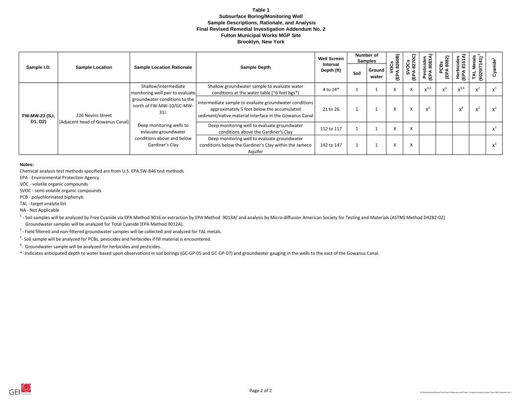
Table 1Subsurface Boring/Monitoring Well
Sample Descriptions, Rationale, and AnalysisFinal Revised Remedial Investigation Addendum No. 2
Fulton Municipal Works MGP SiteBrooklyn, New York
Page 2 of 2 H:\Zdump\Andrea\Revised Final Fulton RI Addendum No2\Table 1 Proposed Sampling Analysis Fulton RIWP Addendum No. 2
SoilGroundwater T
AL
Me
tals
(60
20
/71
41
) 2
Pe
sti
cid
es
(EP
A 8
08
1A
)
VO
Cs
(E
PA
82
60
B)
SV
OC
s
(EP
A 8
27
0C
)
He
rbic
ide
s
(EP
A 8
15
1A
)
PC
Bs
(E
PA
80
82
)
Cy
an
ide1
Sample I.D. Sample Location Sample Location Rationale Sample Depth
Well Screen Interval
Depth (ft)
Number of Samples
Shallow groundwater sample to evaluate water conditions at the water table (~6 feet bgs*)
4 to 14* 1 1 X X X3,4 X3 X3,4 X2 X1
Intermediate sample to evaluate groundwater conditions approximately 5 feet below the accumulated
sediment/native material interface in the Gowanus Canal21 to 26 1 1 X X X4 X4 X2 X1
Deep monitoring well to evaluate groundwater conditions above the Gardiner's Clay
112 to 117 1 1 X X X1
Deep monitoring well to evaluate groundwater conditions below the Gardiner's Clay within the Jameco
Aquifer142 to 147 1 1 X X X1
Notes:
Chemical analysis test methods specified are from U.S. EPA SW-846 test methodsEPA - Environmental Protection AgencyVOC - volatile organic compoundsSVOC - semi-volatile organic compounds PCB - polychlorinated biphenylsTAL - target analyte listNA - Not Applicable1 - Soil samples will be analyzed by Free Cyanide via EPA Method 9016 or extraction by EPA Method 9013A/ and analysis by Micro-diffusion American Society for Testing and Materials (ASTM) Method D4282-02] Groundwater samples will be analyzed for Total Cyanide (EPA Method 9012A).2 - Field filtered and non-filtered groundwater samples will be collected and analyzed for TAL metals.3- Soil sample will be analyzed for PCBs, pesticides and herbicides if fill material is encountered. 4- Groundwater sample will be analyzed for herbicides and pesticides.*- Indicates anticipated depth to water based upon observations in soil borings (GC-GP-05 and GC-GP-07) and groundwater gauging in the wells to the east of the Gowanus Canal.
FW-MW-23 (S,I, D1, D2)
226 Nevins Street [Adjacent head of Gowanus Canal]
Shallow/intermediate monitoring well pair to evaluate groundwater conditions to the north of FW-MW-10/GC-MW-
31I.
Deep monitoring wells to evlauate groundwater
conditions above and below Gardiner's Clay


LEGEND
APPROXIMATE BOUNDARY OFFORMER MANUFACTUREDGAS PLANT (MGP) SITE
RIA SOIL BORING/MONITORING WELL
RIA SOIL BORING
APPROXIMATE CURRENTPROPERTY BOUNDARY
KSF-SB-24
KSF-SB-23/MW-1
PREVIOUS LOCATIONS
NEW YORK STATEDEPARTMENT OFENVIRONMENTALCONSERVATION (NYSDEC)SITE CHARACTERIZATION(SC) BORING
KEYSPAN CORPORATIONGOWANUS CANAL RI BORING
RI SOIL VAPOR POINT
RI SOIL BORING WITHTEMPORARY GROUNDWATERSAMPLE
REMEDIAL INVESTIGATION(RI) MONITORING WELL
RI SOIL BORING
REMEDIAL INVESTIGATION LOCATIONS
RI INDOOR AIR SAMPLE
FW-SB-20
FW-SB-01
FW-MW-01
FW-SV-10
FW-IA-01
FW-SS-06 RI SURFACE SOIL SAMPLE
FW-OA-01 RI OUTDOOR AIR SAMPLE
NYSDEC SC MONITORINGWELL
FW-MW-19FW-SB-41/
FW-SB-40
PROPOSED RIAMONITORING WELL
GC-GP-05
GC-SED-01KEYSPAN CORPORATIONGOWANUS CANAL RISEDIMENT CORE
FW-SB-46 PROPOSED RIA SOIL BORING
PROPOSED REMEDIAL INVESTIGATIONADDENDUM (RIA) No. 2 LOCATIONS
PROPOSED RI MONITORINGWELL
FW-MW-22(S,I)
FW-MW-11
REMEDIAL INVESTIGATION ADDENDUMLOCATIONS
PROPOSED SAMPLE LOCATIONS
0
SCALE, FEET
50 100
February 2011 Figure 1455 WINDING BROOK DRIVE
SUITE 201GLASTONBURY, CONNECTICUT 06033
REMEDIAL INVESTIGATION WORK PLANADDENDUM NO. 2
FULTON MUNICIPAL WORKS FORMER MGPBOROUGH OF BROOKLYN, NEW YORK
PROJECT 093020-1-1108
SOURCES:1. PHOTOGRAPH OBTAINED FROM BLUE SKY INTERNATIONAL LTD. ALL RIGHTS RESERVED.
COPYRIGHT 2006.2. SANBORN FIRE INSURANCE MAPS (1886 THROUGH 1996).3. SITE CHARACTERIZATION REPORT, FULTON FORMER MANUFACTURED GAS PLANT, BROOKLYN (II),
KING'S COUNTY, NEW YORK, SITE No. 2-24-051, SEPTEMBER 2007, PREPARED BY NYSDEC REMEDIALBUREAU C., DIVISION OF ENVIRONMENTAL REMEDIATION.
4. NEW YORK CITY OPEN ACCESSIBLE SPACE INFORMATION SYSTEM http://www.oasisnyc.net,ACCESSED JANUARY 2008.
5. SURVEY OF SAMPLE LOCATIONS CONDUCTED BY GEI CONSULTANTS, INC. ON 3/31/10 and 5/5/10.SURVEY BY NEW YORK STATE LICENSED LAND SURVEYOR NUMBER 050146. HORIZONTAL DATUM:NEW YORK STATE PLANE COORDINATE SYSTEM (LONG ISLAND ZONE, NORTH AMERICAN DATUM(NAD)83). VERTICAL DATUM: NORTH AMERICAN VERTICAL DATUM (NAVD) 88.
NOTES:1. THE LOCATION OF THE PREVIOUS NYSDEC SC BORINGS AND
MONITORING WELLS HAVE NOT BEEN SURVEYED AND SHOULDBE CONSIDERED APPROXIMATE.
2. * INDICATES THE SAMPLE WAS NOT SURVEYED (LOCATIONAPPROXIMATE).
3. ** INDICATES THAT BORING WAS UNABLE TO BE COMPLETEDBECAUSE OF SUBSURFACE FOUNDATION.
4. S = SHALLOW, I = INTERMEDIATE, D1 AND D2 = DEEP WELLS.
I:\Project\National Grid\Fulton\RIWP Addendum\Drawings\Fulton-Proposed Samples-1-24-11.dwg