1.0 INTRODUCTION 1.1 Project background
20
Golder Associates Africa (Pty) Ltd. PO Box 6001, Halfway House, 1685, South Africa, Thandanani Park, Matuka Close, Halfway Gardens, Midrand Tel: [+27] (11) 254 4800 Fax: [+27] (11) 315 0317 www.golder.com Golder Associates: Operations in Africa, Asia, Australasia, Europe, North America and South America Reg. No. 2002/007104/07 Directors: SAP Brown, L Greyling, RGM Heath, FR Sutherland Golder, Golder Associates and the GA globe design are trademarks of Golder Associates Corporation. DATE 06 May 2013 PROJECT No. 11615957_Memo_001_Rev 1 TO Riaz Jogiat uMgungundlovu District Municipality CC Catherine Hughes, Kevan Zunckel, Karen Zunckel, Roland Schulze FROM Candice Allan EMAIL [email protected] PRELIMINARY PRIORITISATION OF VULNERABLE COMMUNITIES FOR CLIMATE CHANGE ADAPTATION IN THE UMGUNGUNDLOVU DISTRICT MUNICIPALITY 1.0 INTRODUCTION Golder Associates Africa (Pty.) Ltd. (Golder), in collaboration with Zunckel Ecological and Environmental Services and the University of KwaZulu-Natal, were requested by the uMgungundlovu District Municipality (UMDM) to undertake a preliminary prioritisation of vulnerable communities within the District, in support of the South African National Biodiversity Institute (SANBI) proposal to the Global Adaptation Fund. The assistance of the Duzi uMngeni Conservation Trust (DUCT) was also sought with regard to the ground- truthing of preliminary findings, and they are acknowledged for their assistance with this exercise. 1.1 Project background During the last two years, the UMDM has commissioned the development of a Strategic Environmental Assessment and Management Plan, as well as a process to develop a Climate Change Response Strategy and Plan for the District. As a result of this work, it has become increasingly clear that the level of socio- economic vulnerability in the District is extremely high, and this is exacerbated by the poor condition of the District’s natural capital. Furthermore, this level of vulnerability is likely to increase under projected climate changes. In response to the call for proposals for grant funding from the Global Adaptation Fund, the UMDM called their service providers and other relevant stakeholders together to collaborate on a joint proposal for a project which will promote adaptation and climate change resilience in the District. The key outcomes of the proposed project are as follows: ¡ Integration of adaptation planning into development, economic and environmental planning processes; ¡ Creation and demonstration of a new planning model for the District which allows for integration of major challenges related to the above processes at a local/district government level, with vertical and horizontal linkages to other levels of state and local partners; ¡ Creation of an Early Warning System for extreme weather events and transformation of municipal disaster response units into disaster risk reduction units; ¡ Introduction and communication of feasible initial adaptation activities for small and subsistence farming; ¡ Introduction of practical initial ecosystem-based adaptation activities that aim to reduce the vulnerability of communities and can assist in creating sustainable livelihoods; and ¡ Creation of an enabling environment for basic service infrastructure, which aims for climate resilient design, manufacture, construction and operation. This outcome should also allow for awareness creation around climate change issues amongst residents of the District, especially the most vulnerable.
Transcript of 1.0 INTRODUCTION 1.1 Project background

Golder Associates Africa (Pty) Ltd.
PO Box 6001, Halfway House, 1685, South Africa, Thandanani Park, Matuka Close, Halfway Gardens, Midrand Tel: [+27] (11) 254 4800 Fax: [+27] (11) 315 0317 www.golder.com
Golder Associates: Operations in Africa, Asia, Australasia, Europe, North America and South America
Reg. No. 2002/007104/07 Directors: SAP Brown, L Greyling, RGM Heath, FR Sutherland Golder, Golder Associates and the GA globe design are trademarks of Golder Associates Corporation.
DATE 06 May 2013 PROJECT No. 11615957_Memo_001_Rev 1
TO Riaz Jogiat uMgungundlovu District Municipality
CC Catherine Hughes, Kevan Zunckel, Karen Zunckel, Roland Schulze
FROM Candice Allan EMAIL [email protected]
PRELIMINARY PRIORITISATION OF VULNERABLE COMMUNITIES FOR CLIMATE CHANGE ADAPTATION IN THE UMGUNGUNDLOVU DISTRICT MUNICIPALITY
1.0 INTRODUCTION Golder Associates Africa (Pty.) Ltd. (Golder), in collaboration with Zunckel Ecological and Environmental Services and the University of KwaZulu-Natal, were requested by the uMgungundlovu District Municipality (UMDM) to undertake a preliminary prioritisation of vulnerable communities within the District, in support of the South African National Biodiversity Institute (SANBI) proposal to the Global Adaptation Fund. The assistance of the Duzi uMngeni Conservation Trust (DUCT) was also sought with regard to the ground-truthing of preliminary findings, and they are acknowledged for their assistance with this exercise.
1.1 Project background During the last two years, the UMDM has commissioned the development of a Strategic Environmental Assessment and Management Plan, as well as a process to develop a Climate Change Response Strategy and Plan for the District. As a result of this work, it has become increasingly clear that the level of socio-economic vulnerability in the District is extremely high, and this is exacerbated by the poor condition of the District’s natural capital. Furthermore, this level of vulnerability is likely to increase under projected climate changes. In response to the call for proposals for grant funding from the Global Adaptation Fund, the UMDM called their service providers and other relevant stakeholders together to collaborate on a joint proposal for a project which will promote adaptation and climate change resilience in the District.
The key outcomes of the proposed project are as follows:
¡ Integration of adaptation planning into development, economic and environmental planning processes;
¡ Creation and demonstration of a new planning model for the District which allows for integration of major challenges related to the above processes at a local/district government level, with vertical and horizontal linkages to other levels of state and local partners;
¡ Creation of an Early Warning System for extreme weather events and transformation of municipal disaster response units into disaster risk reduction units;
¡ Introduction and communication of feasible initial adaptation activities for small and subsistence farming;
¡ Introduction of practical initial ecosystem-based adaptation activities that aim to reduce the vulnerability of communities and can assist in creating sustainable livelihoods; and
¡ Creation of an enabling environment for basic service infrastructure, which aims for climate resilient design, manufacture, construction and operation. This outcome should also allow for awareness creation around climate change issues amongst residents of the District, especially the most vulnerable.

Riaz Jogiat 11615957_Memo_001_Rev 1uMgungundlovu District Municipality 06 May 2013
2/20
Finally, strong monitoring and evaluation processes will be designed to improve on infrastructure performance.
To date, the proposal put forward by the UMDM and its partners has been accepted by SANBI, which is the National Implementing Entity for the Global Adaptation Fund in South Africa. SANBI has requested further engagement with the UMDM and its partners to develop the proposal further. The first step in the project process, which will be discussed with SANBI on 10 April 2013, was to perform a high level analysis to identify key vulnerable communities which would form the initial case studies for the project. This process is described below.
2.0 APPROACH The approach to the prioritisation of the vulnerable communities to be targeted for this project was designed to refine the selection process, as seen in Figure 1.
Figure 1: Approach to the prioritisation of vulnerable communities
2.1 Step 1: Selection of vulnerability-defining characteristics The vulnerability-defining characteristics were selected based on the required outcomes of the project. Target vulnerable communities would therefore display the following characteristics:
¡ Transformed areas vulnerable to increased runoff due to hardened surfaces and lack of basal cover;
¡ Degraded, upstream areas available for rehabilitation, with the potential for downstream impacts;
¡ Mean annual rainfall in recognition of the rainfall variability across the District and the need to prioritise quaternary catchments draining high rainfall areas;
¡ Communities reliant on boreholes, springs, dams, water tanks, rainfall and rivers for water supply;
¡ Communities engaged in subsistence agricultural activities;
¡ Areas known to have a high frequency of flooding and storm events; and
¡ Areas projected to receive increased short duration rainfall (associated with flash flooding) in the future.
Selection of vulnerability-defining characteristics
Closer analysis, selection of potential target communities
and ground-truthing
High level Geographical Information System (GIS) screening and identification of key
quaternary catchments
Riaz Jogiat 11615957_Memo_001_Rev 1uMgungundlovu District Municipality 06 May 2013
3/20
2.2 Step 2: GIS screening and identification of key quaternary catchments Features representing the vulnerability-defining characteristics were mapped using a Geographical Information System (ArcGIS) in order to determine the extent to which communities within the UMDM met the set characteristics, and to facilitate the prioritisation process. Quaternary catchments were used as planning units in which the target communities would be identified (Section 3.0).
2.3 Step 3: Selection of target communities Once key quaternary catchments were identified, communities within these catchments were prioritised based on a focused situational analysis which included consultation with the Duzi Umgeni Conservation
Trust (DUCT) currently undertaking community-based projects in the UMDM, and a site visit for ground-truthing purposes (Section4.0).
3.0 GIS SCREENING AND IDENTIFICATION OF KEY QUATERNARY CATCHMENTS
The GIS screening process and identification of catchments is described in this section.
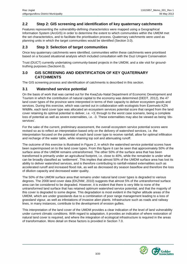
3.1 Watershed service potential On the basis of work that was carried out for the KwaZulu-Natal Department of Economic Development and Tourism in which the contribution of natural capital to the economy was determined (DEDT, 2012), the 47 land cover types of the province were interpreted in terms of their capacity to deliver ecosystem goods and services. During this exercise, which was carried out in collaboration with ecologists from Ezemvelo KZN Wildlife, each land cover type was allocated an ecosystem services potential score that ranged from the land cover retaining its optimal potential to deliver, i.e. +3; through to the worst case scenario, being a complete loss of potential as well as severe externalities, i.e. -3. These externalities may also be viewed as being ‘dis-services’.
For the sake of the current, preliminary assessment, the overall ecosystem service potential scores were revised so as to reflect an interpretation based only on the delivery of watershed services, i.e. the interpretation focused on the potential of each land cover type to receive rainfall, allow for optimal infiltration and recharge of the water table, while retaining top soil and attenuating runoff.
The outcome of this exercise is illustrated in Figure 2, in which the watershed service potential scores have been superimposed on to the land cover types. From this figure it can be seen that approximately 50% of the surface area of the UMDM remains untransformed. The other 50% of the surface area that has been transformed is primarily under an agricultural footprint, i.e. close to 40%, while the remainder is under what can be broadly classified as ‘settlement’. This implies that almost 50% of the UMDM surface area has lost its ability to deliver watershed services, and is therefore contributing to rainfall-related externalities such as accelerated runoff and increased flood risk, as well as decreased dry season baseflow and therefore the loss of dilution capacity and decreased water quality.
The 50% of the UMDM surface area that remains under natural land cover types is degraded to various degrees. The 2008 land cover data (EKZNW, 2010) suggests that almost 5% of the untransformed surface area can be considered to be degraded. However, it is evident that there is very little to none of the untransformed land surface that has retained optimum watershed service potential, and that the majority of this cover is degraded to some degree. This degradation is most evident in the higher altitude areas of the UMDM, which are under grasslands due to a combination of poor range management leading to a loss of grassland vigour, as well as infestations of invasive alien plants. Infrastructure such as roads and railway lines, in many instances, contribute to the development of erosion gullies.
This interpretation of the land cover of the UMDM provides a clear indication of the level of land vulnerability under current climatic conditions. With regard to adaptation, it provides an indication of where restoration of natural land cover is required, and where the integration of ecological infrastructure is required in the areas of transformation. More detail on these factors is provided in Section 7.0.

Riaz Jogiat 11615957_Memo_001_Rev 1uMgungundlovu District Municipality 06 May 2013
4/20
Figure 2: Watershed potential to deliver ecosystems goods and services (based on the Ezemvelo KZN Wildlife 2008 land cover dataset)
The spatial representation of transformation and degradation within the UMDM are shown in the following two sections.
3.1.1 Transformation Varying levels of transformation within the quaternary catchments of the UMDM are represented spatially in Figure 3. The levels of transformation were determined based on the comparative coverage of ecosystem dis-service within the quaternary catchments.

Riaz Jogiat 11615957_Memo_001_Rev 1uMgungundlovu District Municipality 06 May 2013
5/20
Figure 3: Quaternary catchment transformation
3.1.2 Degradation The presence of erosion gullies as provided by the national Department of Agriculture, Forestry and Fisheries (DAFF, 2011) were used as an indicator of land degradation. Quaternary catchments displaying degradation are highlighted in Figure 4. High levels of degradation are noted in the north-eastern catchments feeding the Mooi River and in the south-western catchments feeding the Mkomazi River (specifically in the vicinity of Lower Loteni and Impendle).

Riaz Jogiat 11615957_Memo_001_Rev 1uMgungundlovu District Municipality 06 May 2013
6/20
Figure 4: Quaternary catchment degradation
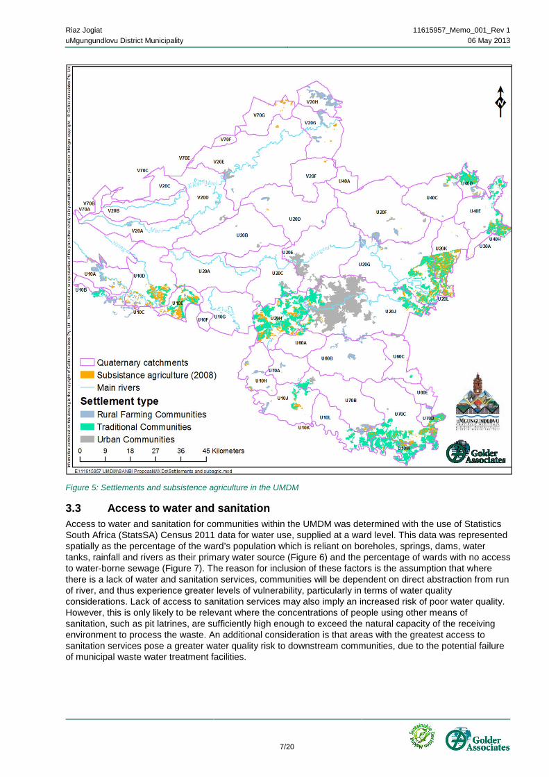
3.2 Settlements and subsistence agriculture Subsistence agriculture within the UMDM was identified with the use of the 2008 Ezemvelo KZN Wildlife land cover dataset. Concentrated pockets of communities undertaking subsistence agriculture activities within the UMDM are highlighted in Figure 5. It must be noted that there is a strong correlation between subsistence agriculture and land tenure, in that the former occurs most abundantly in areas that are under communal land tenure. The bulk of the remaining UMDM agriculture is commercial, and on land under private land tenure. Subsistence farmers are highly vulnerable to climate change as their crops are highly reliant on natural resources and weather patterns.
Riaz Jogiat 11615957_Memo_001_Rev 1uMgungundlovu District Municipality 06 May 2013
7/20
Figure 5: Settlements and subsistence agriculture in the UMDM
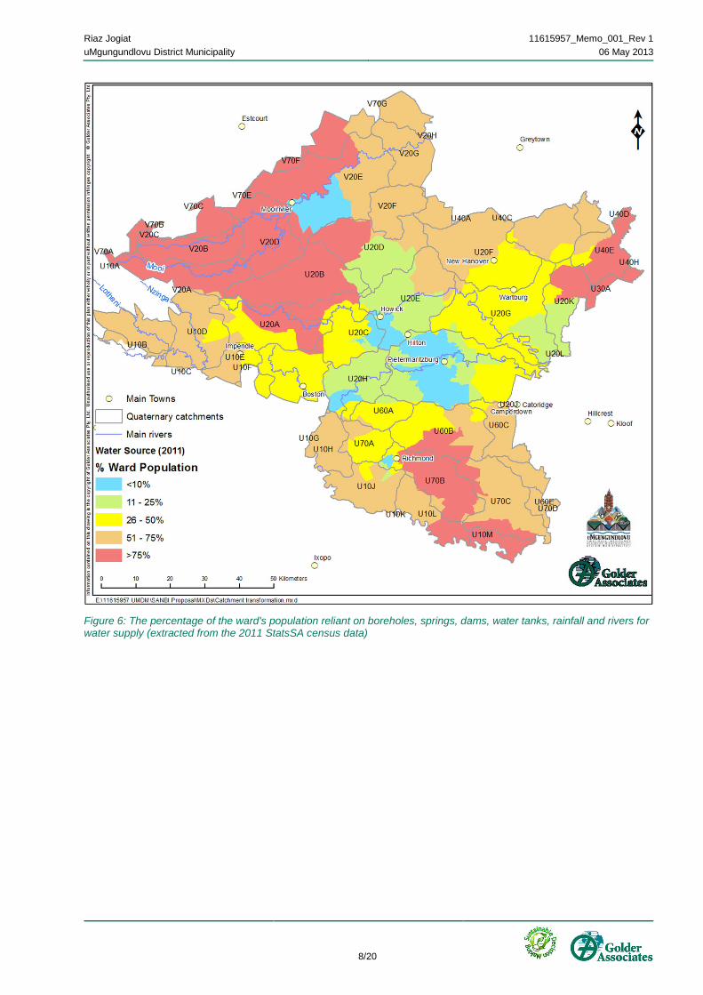
3.3 Access to water and sanitation Access to water and sanitation for communities within the UMDM was determined with the use of Statistics South Africa (StatsSA) Census 2011 data for water use, supplied at a ward level. This data was represented spatially as the percentage of the ward’s population which is reliant on boreholes, springs, dams, water tanks, rainfall and rivers as their primary water source (Figure 6) and the percentage of wards with no access to water-borne sewage (Figure 7). The reason for inclusion of these factors is the assumption that where there is a lack of water and sanitation services, communities will be dependent on direct abstraction from run of river, and thus experience greater levels of vulnerability, particularly in terms of water quality considerations. Lack of access to sanitation services may also imply an increased risk of poor water quality. However, this is only likely to be relevant where the concentrations of people using other means of sanitation, such as pit latrines, are sufficiently high enough to exceed the natural capacity of the receiving environment to process the waste. An additional consideration is that areas with the greatest access to sanitation services pose a greater water quality risk to downstream communities, due to the potential failure of municipal waste water treatment facilities.
Riaz Jogiat 11615957_Memo_001_Rev 1uMgungundlovu District Municipality 06 May 2013
8/20
Figure 6: The percentage of the ward's population reliant on boreholes, springs, dams, water tanks, rainfall and rivers for water supply (extracted from the 2011 StatsSA census data)

Riaz Jogiat 11615957_Memo_001_Rev 1uMgungundlovu District Municipality 06 May 2013
9/20
Figure 7: The percentage of the ward's population with no access to water-borne sewage (extracted from the 2011 STATSSA census data)
3.4 Current rainfall conditions The historical mean annual rainfall spatial dataset was provided by the School of Bioresource Engineering and Environmental Hydrology at the University of KwaZulu-Natal. Considering the current degraded state of the UMDM’s land cover in terms of delivering watershed services, it was considered necessary to include this data layer as an indication of the current levels of vulnerability to rainfall-related risk, with the assumption being that the greater the mean annual rainfall, the greater the risk. It must be noted however that mean annual rainfall is not the best measure of risk as it is more the manner in which the rain falls that will determine the level of risk.

Riaz Jogiat 11615957_Memo_001_Rev 1uMgungundlovu District Municipality 06 May 2013
10/20
Figure 8: Historical mean annual rainfall for the UMDM
3.5 Disaster management Areas that are known to have experienced a high frequency of flooding and storm events in the UMDM are presented in Figure 9. This information was compiled based on spatial disaster records supplied by the Co-operative Governance and Traditional Authority (COGTA), supplemented with records noted in the UMDM Disaster Management Plan (2012).

Riaz Jogiat 11615957_Memo_001_Rev 1uMgungundlovu District Municipality 06 May 2013
11/20
Figure 9: Wards recorded to experience a high frequency of flooding and storm events in the UMDM
3.6 Climate change projections for short-duration (extreme) rainfall The data presented in Figure 10 represents the potential changes in short-duration design rainfall (10 min – 24 hour) within a 2 year return period, which is associated with storms and flash flooding. The quinary catchment level climate change projections for the UMDM were developed by the School of BEEH at the University of KwaZulu-Natal, and provided as Geographical Information Systems (GIS) shapefile representations of the ACRU model’s hydrological outputs1.
An average of four Global Circulation Models (GCMs) was used in this analysis Table 1.
1 For more information on the derivation of these models, please see Golder Associates Report Number 11615957-10991-3, Status Quo Assessment: Climate Trends and Projections, dated November 2011.

Riaz Jogiat 11615957_Memo_001_Rev 1uMgungundlovu District Municipality 06 May 2013
12/20
Table 1: GCMs used for the UMDM climate change projections Institute GCM Abbreviation in this report
Canadian Center for Climate Modelling and Analysis (CCCma), Canada
Name: CGCM3.1(T47) First published: 2005 Website: http://www.cccma.bc.ec.gc.ca/models/cgcm3.shtml
CCC
Meteo-France / Centre National de Recherches Meteorologiques (CNRM), France
Name: CNRM-CM3 First published: 2004 Website: http://www.cnrm.meteo.fr/scenario2004/indexenglish.html
CRM
Max Planck Institute for Meteorology (MPI-M), Germany
Name: ECHAM5/MPI-OM First published: 2005 Website: http://www.mpimet.mpg.de/en/wissenschaft/modelle.html
ECH
Institute Pierre Simon Laplace (IPSL), France
Name: IPSL-CM4 First published: 2005 Website: http://mc2.ipsl.jussieu.fr/simules.html
IPS
Figure 10: Projected ratio change in short duration rainfall towards the mid-century (2045 - 2065) determined using an average of four GCMs (CCC, CRM, ECH and IPS)

Riaz Jogiat 11615957_Memo_001_Rev 1uMgungundlovu District Municipality 06 May 2013
13/20
4.0 SELECTION OF TARGET COMMUNITIES With the selection of target communities, it was assumed that the emphasis of the project should be on those communities deemed to be most vulnerable to projected climate change impacts primarily associated with rainfall variability. As such, vulnerabilities are likely to be related to both the increased incidence of flooding and the increased risk of poor water quality associated with reduced dilution capacity as a result of reduced baseflow. An additional consideration is the link between vulnerable communities and untransformed areas which could be rehabilitated to improve their watershed service potential2.
4.1 Communities vulnerable to flooding Quaternary catchments U20H and U20J, which encompass the catchment of the Msunduzi River, show the greatest correlations between the variables illustrated in Section 3.0 and which are illustrated in Figure 11. A more refined assessment of the relationship between these variables is possible, but not within the timeframes of this preliminary assessment. Therefore, the preliminary indications are that the communities that live within close proximity of the Msunduzi River, from Nzondweni in its upper reaches down to Edendale just upstream of Pietermaritzburg, are already vulnerable, and are at risk of an increase in the intensity and frequency of flood events under climate change. This risk is particularly relevant in terms of the loss of homes, belongings and life.
Further downstream, the risk is more relevant to infrastructure, and in this regard it must be noted that there are a number of important crossings that link communities across the Msunduzi River. Recent history has shown that, in particular, the Woodhouse Road low-level bridge adjacent to Sobantu has been the cause of the loss of lives as people attempt to cross during times of flood. The Grimthorpe Road low-level bridge in Lincoln Meade is an important link for the Bishopstowe farming community’s direct access to the Pietermaritzburg Central Business District.
2 Under these assumptions, it should be noted that transformed areas are excluded from selection for this project. It is in these areas however that the integration of ecological infrastructure could assist in reducing vulnerability, but it is assumed that this falls outside of the scope of the Adaptation Fund’s aims. If this assumption is incorrect, the selection of target communities could be revised.

Riaz Jogiat 11615957_Memo_001_Rev 1uMgungundlovu District Municipality 06 May 2013
14/20
Figure 11: The spatial relationship between various land cover types in the upper and middle sections of the Msunduzi River catchment
While the crossings mentioned above are important as they have a history of vulnerability to flood events, it is also important to note that the N3 crosses the Msunduzi River. While this crossing is a dual carriageway that is relatively high above the surface of the river, flood events of increasing severity could impact on this structure. Considering that the N3 is a strategic economic link between the port city of Durban and Gauteng, such an incident could have drastic consequences for the country’s economy.
It is evident therefore that any vulnerability assessment should extend beyond the boundaries of the UMDM in terms of vulnerable communities and the effects that activities within the UMDM can have on adjacent districts. As such, it is important to note that quaternaries U10A, B, D and E, which include the Impendle area and the drainage basins of the Nzinga and Lotheni Rivers which are tributaries of the Mkomazi River, include substantial portions of land that have been transformed and degraded and thus contribute to a risk of flooding and sediment movement to downstream communities that are within the Sisonke District Municipality. These quaternaries and the associated land cover are illustrated in Figure 12.

Riaz Jogiat 11615957_Memo_001_Rev 1uMgungundlovu District Municipality 06 May 2013
15/20
Figure 12: The spatial relationship between various land cover types in the western regions of Impendle
4.2 Communities vulnerable to decreased water quality Communities living within quaternary catchments that have both a high dependence on direct abstraction from run of river for their access to water as well as a low level of access to a water-borne sewerage system should be prioritised as having the greatest level of vulnerability to poor water quality. Such communities were identified within the following quaternaries:
¡ U10B, D, E and F, i.e. the Impendle area in the upper reaches of the Nzinga and Lotheni Rivers;
¡ V20E, F, G and H, i.e. the lower Mooi River catchment;
¡ U20J and K, i.e. the lower portions of the Msunduzi and uMngeni Rivers above the Nagel Dam; and
¡ U20H; i.e. the upper portions of the Msunduzi River catchment.
The U20H catchment has been included despite its high level of access to water, as it is assumed that the population density of this area is one of the highest in the UMDM. Further work could include population figures as an additional data layer.

Riaz Jogiat 11615957_Memo_001_Rev 1uMgungundlovu District Municipality 06 May 2013
16/20
4.3 Subsistence farming communities The quaternary catchments within the UMDM that include subsistence farming communities are listed below:
¡ U10A, B, D and E, i.e. the Impendle area in the upper reaches of the Nzinga and Lotheni Rivers;
¡ U20H, i.e. the upper portion of the Msunduzi River catchment above Edendale and Pietermaritzburg;
¡ U20J, i.e. the upper portion above Edendale and Pietermaritzburg as well as the lower portion above the confluence with the uMngeni River;
¡ U20G and K, i.e. the lower portions of the uMngeni River above the confluence with the Msunduzi River; and
¡ U40C, D, E and H, i.e. the upper portions of the Mvoti River catchment to the east of New Hanover and Wartburg.
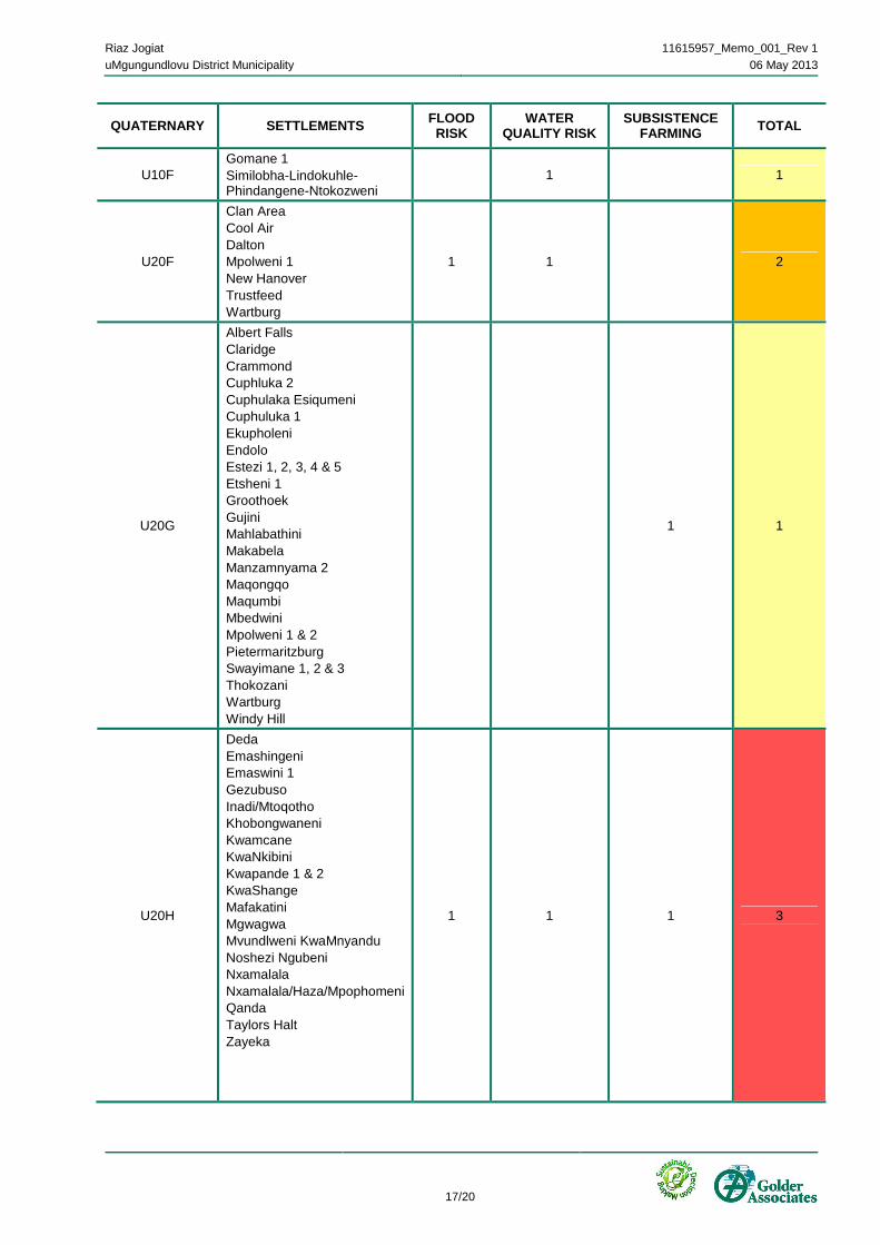
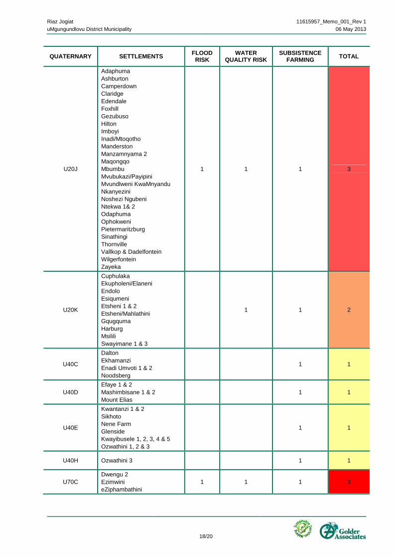
4.4 Summary of vulnerable community selection process From the above three sections, a summary has been compiled which reflects the number of times a quaternary is listed. This has been captured in Table 2 below.
Table 2: A summary of the occurrence of vulnerability aspects per quaternary catchments within the UMDM
QUATERNARY SETTLEMENTS FLOOD RISK
WATER QUALITY RISK
SUBSISTENCE FARMING TOTAL
U10A
Khathikhathi Stoffelton Loteni Mahutshini Manguzi Stepmore Nhlambamasoka Nhlathimbe Nkangala 1, 2 & 3
1 1 2
U10B Manguzi Stepmore Manguzi Thunzi Stoffelton 1
1 1 1 3
U10D
Compensation Enguga 1, 2 & 3 Entshiyabantu KwaNovuka 2 Lower Makhuzeni Makhuzeni Stoffelton 1 & 2 Mohotloeng Nzinga 1, 2, 3 & 4 Stoffelton 1 Swayimane Tsupaneng 1& 2 Upper Makhuzeni
1 1 1 3
U10E
Compensation Gomane 1, 2 & 3 Impendle KwaKhetha KwaNovuka 1 & 2 Macksam 1, 2 & 3 Nhlambamkhosi Similobha-Lindokuhle-Phindangene-Ntokozweni Ukukhanya 1& 2
1 1 1 3
Riaz Jogiat 11615957_Memo_001_Rev 1uMgungundlovu District Municipality 06 May 2013
17/20
QUATERNARY SETTLEMENTS FLOOD RISK
WATER QUALITY RISK
SUBSISTENCE FARMING TOTAL
U10F Gomane 1 Similobha-Lindokuhle-Phindangene-Ntokozweni
1 1
U20F
Clan Area Cool Air Dalton Mpolweni 1 New Hanover Trustfeed Wartburg
1 1 2
U20G
Albert Falls Claridge Crammond Cuphluka 2 Cuphulaka Esiqumeni Cuphuluka 1 Ekupholeni Endolo Estezi 1, 2, 3, 4 & 5 Etsheni 1 Groothoek Gujini Mahlabathini Makabela Manzamnyama 2 Maqongqo Maqumbi Mbedwini Mpolweni 1 & 2 Pietermaritzburg Swayimane 1, 2 & 3 Thokozani Wartburg Windy Hill
1 1
U20H
Deda Emashingeni Emaswini 1 Gezubuso Inadi/Mtoqotho Khobongwaneni Kwamcane KwaNkibini Kwapande 1 & 2 KwaShange Mafakatini Mgwagwa Mvundlweni KwaMnyandu Noshezi Ngubeni Nxamalala Nxamalala/Haza/Mpophomeni Qanda Taylors Halt Zayeka
1 1 1 3
Riaz Jogiat 11615957_Memo_001_Rev 1uMgungundlovu District Municipality 06 May 2013
18/20
QUATERNARY SETTLEMENTS FLOOD RISK
WATER QUALITY RISK
SUBSISTENCE FARMING TOTAL
U20J
Adaphuma Ashburton Camperdown Claridge Edendale Foxhill Gezubuso Hilton Imboyi Inadi/Mtoqotho Manderston Manzamnyama 2 Maqongqo Mbumbu Mvubukazi/Payipini Mvundlweni KwaMnyandu Nkanyezini Noshezi Ngubeni Ntekwa 1& 2 Odaphuma Ophokweni Pietermaritzburg Sinathingi Thornville Vallkop & Dadelfontein Wilgerfontein Zayeka
1 1 1 3
U20K
Cuphulaka Ekupholeni/Elaneni Endolo Esiqumeni Etsheni 1 & 2 Etsheni/Mahlathini Gqugquma Harburg Msilili Swayimane 1 & 3
1 1 2
U40C
Dalton Ekhamanzi Enadi Umvoti 1 & 2 Noodsberg
1 1
U40D Efaye 1 & 2 Mashimbisane 1 & 2 Mount Elias
1 1
U40E
Kwantanzi 1 & 2 Sikhoto Nene Farm Glenside Kwayibusele 1, 2, 3, 4 & 5 Ozwathini 1, 2 & 3
1 1
U40H Ozwathini 3 1 1
U70C Dwengu 2 Ezimwini eZiphambathini
1 1 1 3

Riaz Jogiat 11615957_Memo_001_Rev 1uMgungundlovu District Municipality 06 May 2013
19/20
QUATERNARY SETTLEMENTS FLOOD RISK
WATER QUALITY RISK
SUBSISTENCE FARMING TOTAL
Golube Ismont Jilofohla 1 & 2 Mbila Mid Illovu Mpangisa 1, 2 & 3 Ogagwini 1, 2 & 3 Ukhalo
V20E Mooi River Rondebosch 1 1
V20F No recognised settlements 1 1
V20G Bhumaneni Rocky Drift 1 1
V20H
Amankonka iNkone Muden Nkomba Rocky Drift uMkholwane
1 1
From this analysis, it is concluded that the communities within quaternaries U10B, D and E, as well as U20H and J, should be prioritised for climate change adaptation interventions, noting however that the U10 quaternaries will impact communities that are outside of the UMDM’s area of jurisdiction.
Additional priority quaternaries were found to be U10A and U20K, with both having subsistence farming as a common factor. The remainder of the quaternaries either indicate issues of water quality or subsistence farming.
5.0 GROUND-TRUTHING On the basis of the preliminary indications provided by the spatial data, it was decided that the brief time allocated to ground-truthing should be spent in quaternaries U20J and H. Observations made during this field visit confirmed the following:
¡ The untransformed portions of these quaternaries all show evidence of high levels of degradation, with gully erosion and invasive alien plant infestations being the most common symptom;
¡ The upper reaches of quaternary U20H are dominated by a combination of rural settlements and subsistence agriculture. The latter occurs in the form of dryland cropping, primarily within close proximity of drainage lines and extensive livestock grazing which has resulted in the loss of grassland vigour and catchment integrity. Even the source of the Msunduzi River appears to be a turbid pool, showing signs of eutrophication; and
¡ Settlements are located within close proximity to drainage lines, including the main stem of the Msunduzi River, with evidence of new settlements being established within areas that are clearly in the floodplain.
Due to time constraints, photographic examples of the above observations have not been included in this report, but geo-referenced photographs are available if required.
6.0 LIMITATIONS This Technical Memorandum should be seen as a preliminary assessment, given the short timeframe available for data collection, processing and analysis. The limitations are listed in more detail below.
¡ Data availability – the lack of floodline data for the District limited the identification of communities directly and immediately vulnerable to flooding;

Riaz Jogiat 11615957_Memo_001_Rev 1uMgungundlovu District Municipality 06 May 2013
20/20
¡ Data resolution – many datasets were only available at ward level; and
¡ Currency of the data – the most recent available land-cover dataset was generated in 2008. The UMDM is currently experiencing rapid growth and transformation which may have been excluded from the analysis.
7.0 RECOMMENDATIONS It is recommended that the areas of the UMDM that require particular attention in terms of climate change adaptation work are those within the catchment of the Msunduzi River, i.e. quaternaries U20H and J. Considering that this system is evidently highly stressed, and will continue to be degraded if effective interventions are not put in place, it certainly reflects the area within the UMDM that has the greatest potential to demonstrate the benefit of adaptation interventions. In addition to the fact that the system flows through the KZN political capital, it also hosts a high profile canoeing event which will benefit from any positive changes and provide publicity for any evident adaptation efforts. Furthermore, the Msunduzi River is currently viewed as being the cause of the rapid deterioration of water quality in the uMngeni River system, and that this system currently underpins the economy of KZN through the economic capital of Durban. Adaptation interventions in the Msunduzi River catchment will thus have local, provincial and national impact.
It must be noted that the time and budget available for this work allowed for limited ground truthing and as such the above recommendation carries a degree of bias. It is therefore essential that additional ground truthing be done to assess the other quaternaries that are highlighted in Table 2. Prior to this work though the settlement data layer needs to be refined to include population and demographic data which can be used to further refine the selection of vulnerable communities.
Whereas the primary focus of this project may be on ecosystem adaptation and thus the restoration of degraded natural areas, the best results from this catchment will be seen if this approach can be coupled with the integration of ecological infrastructure into areas that are under both agricultural and settlement footprints.
8.0 REFERENCES
¡ Department of Agriculture, Forestry and Fisheries (2011) Gullies dataset.
¡ Department of Economic Development and Tourism (DEDT) (2012) Profiling District Economic Drivers: A Provincial Overview. A report compiled by Isikhungusethu Environmental Services for DEDT
¡ EKZNW (Ezemvelo KwaZulu-Natal Wildlife) (2010) 2008 KZN Province Land Cover Mapping (from SPOT5 Satellite imagery circa 2008); Data Users Report and Meta Data (version1.0). Prepared for Ezemvelo KwaZulu-Natal Wildlife by GeoterraImage (Pty.) Ltd., South Africa, October 2010.
¡ Statistics South Africa (StatsSA) Census 2011 Ward Dataset
¡ uMgungundlovu District Municipality (2012) Disaster Management Plan
Candice Allan Catherine Hughes Co-ordinator Project Manager CAA/CH/rg z:\projects\11615957_umgungundlovu_cc_response\2_correspondence\11615957_tech_memo_001_rev1.docx


![NTP REPORT ON CARCINOGENS BACKGROUND ......NTP Report on Carcinogens 1996 Background Document for Azacitidine 1.0 INTRODUCTION Azacitidine [320-67-2] 1.1 Chemical Identification Azacitidine](https://static.fdocuments.us/doc/165x107/5f389e46814f462fcd08ae75/ntp-report-on-carcinogens-background-ntp-report-on-carcinogens-1996-background.jpg)