10 I MPLEMENTATION IMPLEMENTATION Newport Banning Ranch 10-1 mdp chapter 10, implementation 08.19.11...
20
10 IMPLEMENTATION Newport Banning Ranch 10-1 mdp chapter 10, implementation 08.19.11 final.docx • August 19, 2011 10.1 Purpose and Intent This chapter describes the applicability the NBR-MDP, the procedures for administration and enforcement of the NBR-MDP, the Project sequencing concept, and the sequencing of City and Coastal Commission approvals required to implement the Project. 10.2 Applicability All development activity within the Project Site is subject the requirements of the NBR-MDP. 10.3 Interpretations The Community Development Director (Director) has the authority to interpret the meaning or applicability of provisions of the NBR-MDP, including maps, and to apply and/or enforce the NBR-MDP. All interpretations by the Director shall be issued in writing. The Director may also refer any issue of interpretation to the Planning Commission (Commission) for input or a determination. An interpretation made by the Director may be appealed to the Commission in compliance with NBMC Chapter 20.64 (Appeals). When used in the NBR-MDP, the words "shall," "must," "will," "is to," and "are to" are always mandatory. "Should" is not mandatory but is strongly recommended; and "may" is permissive. The present tense includes the past and future tenses; and the future tense includes the present. The singular number includes the plural number, and the plural the singular, unless the common meaning of the word indicates otherwise. The words "includes" and "including" shall mean "including, but not limited to." 10.4 Severability If any portion of the NBR-MDP is, for any reason, declared by a court of competent jurisdiction to be invalid or ineffective in whole or in part, such decision shall not affect the validity of the remaining portions of the NBR-MDP. The NBR-MDP and each portion thereof would have been approved by the City Council irrespective of the fact that one or more portions may be declared invalid or ineffective.
Transcript of 10 I MPLEMENTATION IMPLEMENTATION Newport Banning Ranch 10-1 mdp chapter 10, implementation 08.19.11...

10 IMPLEMENTATION
Newport Banning Ranch 10-1mdp chapter 10, implementation 08.19.11 final.docx • August 19, 2011
10.1 Purpose and Intent This chapter describes the applicability the NBR-MDP, the procedures for administration and enforcement of the NBR-MDP, the Project sequencing concept, and the sequencing of City and Coastal Commission approvals required to implement the Project.
10.2 Applicability All development activity within the Project Site is subject the requirements of the NBR-MDP.
10.3 Interpretations The Community Development Director (Director) has the authority to interpret the meaning or applicability of provisions of the NBR-MDP, including maps, and to apply and/or enforce the NBR-MDP. All interpretations by the Director shall be issued in writing. The Director may also refer any issue of interpretation to the Planning Commission (Commission) for input or a determination. An interpretation made by the Director may be appealed to the Commission in compliance with NBMC Chapter 20.64 (Appeals). When used in the NBR-MDP, the words "shall," "must," "will," "is to," and "are to" are always mandatory. "Should" is not mandatory but is strongly recommended; and "may" is permissive. The present tense includes the past and future tenses; and the future tense includes the present. The singular number includes the plural number, and the plural the singular, unless the common meaning of the word indicates otherwise. The words "includes" and "including" shall mean "including, but not limited to."
10.4 Severability If any portion of the NBR-MDP is, for any reason, declared by a court of competent jurisdiction to be invalid or ineffective in whole or in part, such decision shall not affect the validity of the remaining portions of the NBR-MDP. The NBR-MDP and each portion thereof would have been approved by the City Council irrespective of the fact that one or more portions may be declared invalid or ineffective.

MASTER DEVELOPMENT PLAN
10-2 mdp chapter 10, implementation 08.19.11 final.docx • August 19, 2011
10.5 Enforcement Any use or development established as a result of a permit or plan approved pursuant to the approved NBR-MDP, but not in compliance with all such conditions, requirements, and standards of the NBR-MDP will be in violation of the NBR-MDP. The provisions of Chapter 20.68, “Enforcement,” of the NBMC are applicable to all activities within the Project Site.
10.6 Development Activities Allowed Pursuant to City Approval of
the NBR‐MDP 10.6.1 Allowable Activities Following Approval of the NBR‐MDP‐ Subsequent Site
Development Review Not Required
Following approval by the City of the Master Development Plan the following development activities are permitted subject to approval of TTM No. 17308, included as Appendix E, and any required permits from local, State (including Coastal Commission), and Federal agencies with permitting jurisdiction over the activity. Approval of Site Development Review by the City is not required for these allowed development activities. 1. Remediation activities within the entire Project Site pursuant to a Final Remediation Action
Plan approved by appropriate state and local agencies;
2. Rough grading within the entire Project Site including bluff/slope restoration and remedial grading to address geotechnical and soils issues, as depicted on approved TTM No. 17308, included as Appendix E of the NBR-MDP;
3. Construction of all public roadways, utilities, and backbone drainage and infrastructure improvements as depicted on approved TTM No. 17308, included as Appendix E of the NBR-MDP;
4. Limited clearing and grading within the Open Space Preserve required for restoration of permanent open space areas and creation of habitat mitigation areas for future restoration, creation of trails, remediation of arroyo drainage courses and other eroded areas, and water treatment areas associated with approved water quality management plans, and for selective bluff/slope restoration and mitigation, all consistent with the Habitat Restoration Plan included as Appendix A of the NBR-MDP;

IMPLEMENTATION
Newport Banning Ranch 10-3
5. Implementation of the Habitat Restoration Plan within the Open Space Preserve included as Appendix A of the NBR-MDP to implement project design features and mitigate for impacts of the NBR-MDP;
6. Consolidation of oil production facilities into the Consolidated Oil Sites which are activities regulated by DOGGR;
7. Environmental protection measures required by the Habitat Restoration Plan, Appendix A of the NBR-MDP, the NBR- EIR, State and Federal Resource Agencies, and/or Coastal Commission; and
8. Implementation of the Fuel Management Plan components of the Fire and Life Safety Program (Appendix B) that lie within and adjacent to public road rights-of-way and within Fire Management Zone “C” areas as depicted in Appendix B.
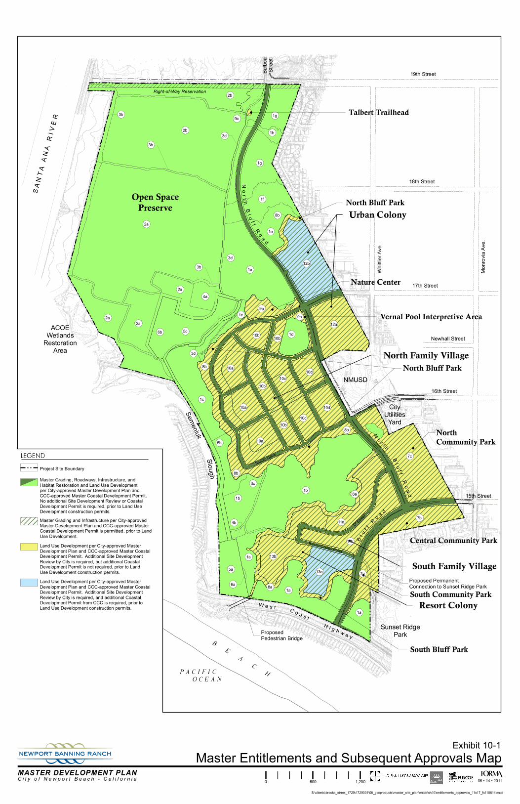
Those areas of the Project Site within which development may proceed pursuant to approval of the NBR-MDP with no additional Site Development Review approvals are illustrated on Exhibit 10-1, “Master Entitlements and Subsequent Approvals Map.” 10.6.2 Activities Requiring Subsequent Site Development Review Approval
Following approval by the City of the NBR-MDP the following development activities are permitted within the Project Site subject to recordation of Final Map No. 17308 and any subsequent subdivision map(s), approval by the City of Site Development Review pursuant to NBR-PC Section 4.5, “Site Development Review,” any additional local required permits, and any permits from State (including Coastal Commission), and Federal agencies with permitting jurisdiction over the activity: 1. Construction of residential, commercial, and visitor serving resort uses in all Villages and
Colonies;
2. Construction of Bluff Parks and Interpretive Parks; and
3. Construction of the Community Park.
Those areas of the Project Site within which development may proceed pursuant to approval of the NBR-MDP and additional Site Development Review approvals are illustrated on Exhibit 10-1, “Master Entitlements and Subsequent Approvals Map.”

MASTER DEVELOPMENT PLAN
10-4 mdp chapter 10, implementation 08.19.11 final.docx • August 19, 2011
10.7 Coastal Development Permit 10.7.1 Master Development Permit
Following City approval of the NBR-MDP, the Developer shall submit the approved NBR-MDP to the California Coastal Commission as application for approval of a Master Coastal Development Permit. Development activities allowed subject to approval of a Master Coastal Development Permit (MCDP) by the California Coastal Commission shall include the activities described in NBR-MDP Section 10.6.1 and those activities listed in NBR-MDP Section 10.6.2 which are also described in NBR-MDP Chapter 3 as a Project Development Plan. Project Development Plans are those plans within NBR-MDP Chapter 3 with a sufficient level of detail for the Coastal Commission to approve the development plan as a construction level site plan as listed below: 1. Open Space Preserve Project Development Plan;
2. North Family Village Project Development Plan;
3. South Family Village Project Development Plan and Pedestrian Bridge across West Coast Highway;
4. North Bluff Park Project Development Plan;
5. South Bluff Park Project Development Plan;
6. Urban Colony Project Development Plan for Site Planning Area 12a;
7. Resort Colony Project Development Plan for Site Planning Area 13b; and
8. Community Park Project Development Plan.
Exhibit 10-1 “Master Entitlements and Subsequent Approvals Map,” depicts the areas within the Project Site which may be developed pursuant to approval by the Coastal Commission of the MCDP. 10.7.2 Additional Coastal Development Permit(s)
Additional Coastal Development Permit approval shall be required for those activities described in NBR-MDP Chapter 3 as Conceptual Development Plans. Conceptual Development Plans are not sufficiently detailed to serve as construction level plans, however they may be approved as a suitable land use as part of the approval of the NBR-MCDP by the California Coastal Commission. Conceptual Development Plans included within NBR-MDP Chapter 3 are listed below:

IMPLEMENTATION
Newport Banning Ranch 10-5
1. Urban Colony Conceptual Development Plan for Site Planning Area 12b; and
2. Resort Colony Conceptual Development Plan for Site Planning Area 13a.
Exhibit 10-1, “Master Entitlements and Subsequent Approvals Map,” depicts the areas within the Project Site which require additional Coastal Commission approval of a CDP. Following City approval of Site Development Review for the activities included as a Conceptual Plan in the NBR-MDP, a corresponding Project CDP application will be filed with the Coastal Commission for their review and approval. 10.7.3 Authorization for City to Issue Construction‐Level Permits as part of MCDP
The MCDP shall authorize the City to be the final review authority for any subsequent planning development permits and construction level permits, as required by the NBR-PC, for implementation of those activities described in Section 10.6 of the NBR-MDP and within the areas illustrated on Exhibit 10-1, without additional Coastal Development Permits, provided the subsequent permits are consistent with the NBR-MDP Project Development Plans. Subsequent required planning development permits and construction level permits shall include, but are not limited to, Site Development Review, Use Permits, Final Tract Maps, final grading permits, model home permits, building permits, and other required permits.
10.7.4 Final Maps, Planning and Construction Permits
Following Coastal Commission approval of the MCDP and additional CDPs and prior to commencement of development activities the Developer shall obtain final construction permits, final subdivision maps and any other required City, state and Federal permits as required for the development activity.

MASTER DEVELOPMENT PLAN
10-6 mdp chapter 10, implementation 08.19.11 final.docx • August 19, 2011
10.8 Sequencing Concept 10.8.1 Overview
Development of the Villages and Colonies and Parklands within the NBR-MDP shall be implemented to respond to market conditions at the time of development and will be coordinated with the implementation of environmental and public-benefit activities. Implementation of environmental and public benefit activities shall precede development of Villages and Colonies and include, but are not limited to oilfield clean-up and remediation, oil facility consolidation, habitat protection, restoration and/or mitigation, public roadway and infrastructure construction, sequenced dedication of public open space and community parks, improvement of public trails, bluff parks, interpretive parks, and other public improvements as required by the NBR-EIR, NBR Master Coastal Development Permit (CDP), NBR Pre-Annexation Agreement and Development Agreement (Development Agreement) and TTM No. 17308. Development will be sequenced generally from south to north within the Project Site as illustrated on Exhibit 10-2, “Conceptual Sequencing for Villages, Colonies, and Parklands.” 10.8.2 Oilfield Consolidation, Clean‐up, and Remediation
Oilfield consolidation, clean-up, remediation and habitat restoration within the boundaries of a Village, Colony or Parkland shall be completed prior to grading for the development of any new land uses within these areas. Oilfield consolidation, clean-up remediation, and habitat restoration within the Open Space Preserve shall be completed as defined in the Habitat Restoration Plan. 10.8.3 Rough and Precise Grading and Bluff/Slope Restoration
Rough and precise grading, including required restoration of bluffs and slopes, remedial grading and over excavation shall precede the construction of public roadways and infrastructure, habitat restoration within the Open Space Preserve (a portion of the habitat restoration within the Open Space Preserve as defined by the HRP will occur prior to commencement of any Project grading activities), improvements within the North and South Bluff Parks and the Interpretive Parks, and public and private land use development. This includes habitat restoration within the Open Space Preserve, as well as the construction of public roadways and infrastructure and land use improvements within the North Bluff Parks and the Interpretive Parks. Oil field consolidation, and a portion of the clean-up and remediation will occur prior to grading, as defined by the Remediation Action Plan.

IMPLEMENTATION
Newport Banning Ranch 10-7
10.8.4 Public Roadways and Infrastructure
Construction of public roadways and infrastructure shall begin in the southern portion of the Project Site, and proceed generally from south to north. The timing for construction of public roadways and infrastructure will occur pursuant to the requirements of the NBR-EIR, TTM No. 17308, and the NBR Development Agreement. 10.8.5 Restoration and Dedication of Open Space Preserve/Dedication of
Interpretative Trails
Habitat restoration and creation within the Open Space Preserve shall be conducted in accordance with the NBR-EIR Mitigation Monitoring Program, the NBR Habitat Restoration Plan (NBR-MDP Appendix A), and the requirements of State and Federal Resource Agencies and the Coastal Commission. Dedication of the Open Space Preserve and trails shall be implemented to correspond with the sequencing of the completion of the Villages and Colonies, generally from south to north. The bluff trail will be implemented and dedicated for public use as the adjacent Villages and Colonies are completed. The trails in the Open Space Preserve will be dedicated for public use as defined by the restoration program outlined in the Habitat Restoration Plan and pursuant to the requirements of TTM No. 17308. The Open Space Preserve may be divided into smaller geographic subareas by future Tentative and Final Tract Maps, Parcel Maps, and metes and bounds or other accepted land conveyance descriptions to allow for sequenced fee dedications, easements, and/or other conservation protections to facilitate implementation of the Open Space Preserve. 10.8.6 Sequencing of Villages, Colonies, and Parklands
Development of the Villages and Colonies and Parklands within the NBR-MDP shall be implemented to respond to market conditions at the time of development and will be coordinated with the implementation of environmental and public-benefit activities. Development will occur generally from south to north.

MASTER DEVELOPMENT PLAN
10-8 mdp chapter 10, implementation 08.19.11 final.docx • August 19, 2011
10.8.7 Improvement and Dedication of Parklands
Public park lands, trails, and other recreation facilities will be improved and dedicated for public use as described below. 1. Bluff Parks The South and North Bluff Park shall be improved as part of the development of the adjacent Village or Colony as depicted on Exhibit 10-1. These parks will be owned-in-fee by an HOA, and will be protected in perpetuity for public use by the dedication of public recreation and/or open space easements. 2. Interpretive Parks The Nature Center and Vernal Pool Interpretive Area(1) shall be improved as part of the Project as outlined in the NBR-EIR and Habitat Restoration Plan and as depicted on Exhibit 10-1. These Interpretive Parks will be owned-in-fee by an HOA and/or a qualified non-profit entity, and will be protected in perpetually for public use by the dedication of public recreation and/or open space easements. The Talbert Staging Area will be improved in conjunction with the Open Space Preserve restoration and will be owned and protected for public use in the same manner as the adjacent Open Space Preserve. 3. Community Park The public Community Park shall be improved as part of the Project and dedicated to the City in accordance with the conditions of approval of TTM No. 17308 and the requirements of the NBR-Development Agreement. 4. Pedestrian Bridge over West Coast Highway The developer shall construct a pedestrian bridge over West Coast Highway, as part of the Project provided all approvals can be obtained from Caltrans and other public agencies with jurisdiction over this bridge. Construction of the bridge shall sequenced with the Villages and Colonies to respond to market conditions.
(1) The Vernal Pool (SPA 1d) will be owned and protected in the same manner as other Upland Habitat
Conservation, Restoration, and Mitigation Site Planning Areas within the Open Space Preserve as defined in the Habitat Restoration Plan.

IMPLEMENTATION
Newport Banning Ranch 10-9
10.9 Site Development Review City approval of Site Development Review shall be required for the following development activities within the NBR-MDP: 1. Construction of Residential, commercial, and visitor-serving resort uses in all Villages and
Colonies; and
2. Construction of Bluff Parks, Interpretive Parks, and the Community Park.
Applications for Site Development Review shall be filed and reviewed in accordance with the provisions of NBR-PC Section 4.5., “Site Development Review.” Exhibit 10-1 “Master Entitlements and Subsequent Approvals Map,” depicts the areas within the Project Site which require City approval of Site Development Review.
10.10 Applicability and Implementation of Design Guidelines Adoption of the NBR-MDP includes adoption of the design guidelines contained in Chapter 6, "Architectural Design Guidelines,” of the NBR-MDP, which shall be the sole architectural design criteria by which development projects within the Project Site are reviewed and approved. The Design Guidelines are intended to be flexible in nature while establishing basic evaluation criteria for the review by the City of development projects during Development Plan Review, subdivision review, and review of any other applicable development applications determined by the Director to be necessary as part of the submittal of project applications. These guidelines consist of architecture, color palettes and other design factors that relate to the setting, open space and project location. Refinements to architectural design guidelines described in Chapter 6, are permitted provided such refinements remain consistent with the regulations and standards set forth in the NBR-PC.
10.11 Use Permits City approval of a use permit shall be required for certain uses within the NBR-MDP in accordance with NBR-PC Section 3.13.11, “Allowable Uses.” Applications for Use Permits shall be submitted and reviewed in accordance with the provisions of NBR-PC Section 4.9, “Use Permits.”

MASTER DEVELOPMENT PLAN
10-10 mdp chapter 10, implementation 08.19.11 final.docx • August 19, 2011
10.12 Minor Modifications The following are considered minor modifications to the NBR-MDP including Exhibit 1-4, “Site Planning Areas Map,” Exhibit 3-1, “Master Development Plan,” and Exhibit 3-2, “Master Development Table.” 10.12.1 Land Use Acreage Refinements
A change in the Site Planning boundary lines as illustrated on Exhibit 1-4 “Site Planning Areas Map,” and corresponding change in the Gross Acres for the respective Site Planning Area as described on Exhibit 1-5, “Site Planning Areas Table,” of up to fifteen percent (15%) are permitted as part the approval of either a Site Development Review, or subdivision map application submitted for the Site Planning Area, provided the refinement(s) to Gross Acres does not result in: 1. A reduction in the total area allocated to the Lowland Open Space/Public Trails and Facilities
District to less than 115 gross acres;
2. A reduction in the total area allocated to the Upland Open Space/Public Trails and Facilities District to less than 85 gross acres;
3. A reduction in the total area allocated to the Public Parks/Recreation District to less than 28 gross acres;
4. The total area within the Project Site boundaries exceeding 401.1 gross acres;
5. Less than two roadway access points from North Bluff Road into the North Family Village; and/or
6. Less than two roadway access points into both the South and North Family Village.
10.12.2 Transfer of Residential Dwelling Units
1. A change in the number of residential dwelling units for any Site Planning Area as described on Exhibit 1-5, “Site Planning Areas Table,” resulting from a transfer of residential dwelling units from one Site Planning Area to another, is permitted as part of the approval of a Site Development Review provided:
a. The transfer does not result in an increase of more than fifteen percent (15%) in the total number of dwelling units described on Exhibit 1-5, “Site Planning Areas Table,” for the Site Planning Area receiving additional dwelling units;
b. The total number of dwelling units for the Project Site does not exceed 1,375;

IMPLEMENTATION
Newport Banning Ranch 10-11
c. All dwelling units planned within the Site Planning Area can be developed in accordance with the applicable development regulations established in NBR-PC Chapter 3, “Land Use and Development Regulations,” for the housing types planned for development;
d. A traffic analysis performed by the City’s Traffic Engineer evaluating the total number of PM peak hour trips that would be generated by development allowed with and without the transfer concludes that there would not be any greater traffic impact generated as a result of the transfer than would be generated without the transfer. Trip generation rates shall be based on standard trip generation values in the current version of ITE’s “Trip Generation,” unless the Traffic Engineer determines that other rates are more valid for the uses involved in the transfer;
e. The total number of dwelling units within the Urban Colony does not exceed 730; and
f. A corresponding subdivision map is approved by the City if the transfer results in a change to any previously approved subdivision map.
10.12.3 Additional Minor Modifications
The following constitute additional allowable minor modifications to the NBR-MDP, which may be approved as part of Site Development Review or subdivision review: 1. Change in utility or public service provider as described in NBR-MDP Chapter 8, "Master
Roadway and Infrastructure Plans;"
2. Change in roadway alignment of any roadway illustrated on the “Master Roadway Plan” of the NBR-MDP when the change results in a centerline shift of 150 feet or less;
3. Change to roadway sections as described in NBR-MDP Chapter 8, "Master Roadway and Infrastructure Plans;
4. Refinements to the Architectural Design Guidelines pursuant to Section 10.10;
5. Refinements to the mix, distribution, and design of architectural products with as a part of subsequent Site Development Review and construction drawings provided that:
a. The character and style of the architecture remains consistent with the intent of the Project’s architectural style;
b. The nominal lot size dimensions and nominal building square footages do not exceed 20% of the original architecture proposed within the Site Planning Area; and

MASTER DEVELOPMENT PLAN
10-12 mdp chapter 10, implementation 08.19.11 final.docx • August 19, 2011
c. All applicable development regulations and standards set forth in the NBR-PC are complied with.
10.12.4 Applications for Minor Modifications
1. Applications for minor modifications to the NBR-MDP shall include the following information:
a. Text revisions to the NBR-MDP submitted to the City in a “track changes” format to note the insertion(s) and/or deletion(s) of text for each changed page;
b. Revised applicable NBR-MDP exhibit(s) reflecting the proposed change(s) and in the case of land use acreage refinements or transfer of residential dwelling unit, a revised Site Planning Areas Table;
c. A summary of: (1) the number of dwelling units, commercial square footage, and overnight accommodations previously approved on all Tentative and all recorded Final Tract Maps; and (2) the number of dwelling units, commercial square footage, and overnight accommodations under construction or completed/occupied at the time of the proposed minor modification;
d. Identification of the ownership of the Site Planning Area(s) to be affected by the minor modification;
e. Analysis of consistency with the NBR-PC; and
f. Any additional background and/or supporting information which the Director deems necessary.
10.12.5 Review of Applications for Minor Modifications
Applications for minor modifications shall be reviewed in conjunction with a development application for a Site Development Review and/or a subdivision map approval. The review authority for a minor modification to the NBR-MDP shall be the same review authority as established in the NBR-PC with authority to approve or conditionally approve the development application being considered in conjunction with a request for a minor modification.

IMPLEMENTATION
Newport Banning Ranch 10-13
10.13 Amendments to the NBR‐MDP All proposed changes to the NBR-MDP other than those identified in Section 10.12, “Minor Modifications,” shall be considered amendments to the NBR-MDP and shall be reviewed in accordance with the provisions of NBR-PC Section 4.4 ”Master Development Plan.”
10.14 Amendments to the Master CDP Amendments to the MCDP are considered to be those changes considered as amendments to the NBR-MDP pursuant to NBR-MDP Section 10.13. Following City approval of any amendment to the NBR-MDP a corresponding application for an amendment to the MCDP shall be submitted for approval to the California Coastal Commission.

MASTER DEVELOPMENT PLAN
10-14 mdp chapter 10, implementation 08.19.11 final.docx • August 19, 2011
10.15 Subdivision Map 10.15.1 Tentative Tract Map No. 17308
Tentative Tract Map (TTM) No. 17308, included as Appendix E, is the implementing subdivision map for the NBR-MDP. TTM No. 17308 describes the subdivision of the Project Site into lots for public dedication or conveyance, fee and condominium lots for residential development and conveyance to home-buyers, and/or for financing and conveyance to builders which may also be further subdivided for the development of conventional fee lots, planned developments, and/or condominiums. TTM No. 17308 also describes the plan for grading and bluff restoration, roadways, infrastructure, and other public improvements to serve the subdivision. TTM No. 17308 is prepared in conformance with the State Subdivision Map Act, the City of Newport Beach Subdivision Ordinance, and Section 4.7, “Subdivision Maps,” of the NBR-PC. TTM No. 17308 defines and delineates: 1. Numbered lots;
2. Lettered lots;
3. Easements for public trails, public utilities, and other improvements;
4. Public streets; and
5. Backbone infrastructure facilities.
Numbered lots are used for residential, resort, commercial, and park development areas to include habitable buildings/structures. Lettered lots are used for open space and landscape areas where no habitable structures are allowed and include habitat restoration areas, buffers, drainage management areas, fire management zones, enhanced parkways, and common planting areas, and similar open space/landscape purposes. The lotting and street layouts correspond with and reflect the lotting pattern and street pattern shown on the NBR-MDP. Site Planning Areas illustrated on the NBR-MDP for public interpretive trails within the Open Space Preserve are a minimum of 20 feet in width to accommodate 10-foot-wide easements for the public interpretive trails. The wider Site Planning Areas are provided to allow meandering of the 10-foot-wide interpretive trail easements in order to avoid or minimize impacts on wetlands and sensitive habitats.

IMPLEMENTATION
Newport Banning Ranch 10-15
TTM No. 17308 also shows the location and design of sewer mains, water mains, storm drains, storm water detention basins, and water quality treatment basins. Typical street cross-sections, land use tables, Standard Plan deviations, and notes pertinent to the subdivision are also included on TTM No. 17308. 10.15.2 Final Map No. 17308
One or more Final Tract Maps shall be prepared and recorded in substantial conformance with approved TTM No. 17308.

Right-of-Way Reservation
S A N
T A
A N A
R I V
E R
ACOEWetlands
RestorationArea
18th Street
Whitti
er Av
e.
Monro
via Av
e.
17th Street
Newhall Street
16th Street
15th Street
19th StreetBalbo
aStr
eet
W e s t C o a s tH i g h w a y
SemeniukSlough
Sunset RidgePark
Ro a d
B l u f f
ProposedPedestrian Bridge
Proposed PermanentConnection to Sunset Ridge Park
NMUSD
B l uf f
R o a d
Nor t h B
l u f f R o a d
N o r t h
CityUtilities
Yard
2b
1b1b
1a
13b
13a5a
6a
11b
1a
7c
3c
5b
8b
10a
10c
10d
10b
12a
1d
1c
10a
12b1e
4a2a
5c6b2a
2a
3b
1e
1f
2a
3b
2b
1h
3d
11a
1g9c
8b
3b
1c
3d
8a
7b
1a
9b
4b
10b
10b10c
10b
10d
8b
8a
8b
9a
7a
1g
3d
10a
Urban ColonyU
North Family Village
South Family Village
Resort Colony
Scenic Drive
'D' Street
Resort Colony Road
Talbert Trailhead
North Bluff Park
!
Nature Center
!
Vernal Pool Interpretive Area!
North Bluff Park!
NorthCommunity Park
!
Central Community Park
South Community Park
!
!
South Bluff Park
!
!
!
Open SpacePreserve
06 • 14 • 2011
S:\clients\brooks_street_1729\1729001\08_gis\products\master_site_plan\mxds\ch10\entitlements_approvals_11x17_fs110614.mxd
Exhibit 10-1Master Entitlements and Subsequent Approvals Map
0 600 1,200
LEGENDProject Site Boundary
Master Grading and Infrastructure per City-approvedMaster Development Plan and CCC-approved MasterCoastal Development Permit is permitted, prior to LandUse Development.Land Use Development per City-approved MasterDevelopment Plan and CCC-approved Master CoastalDevelopment Permit. Additional Site DevelopmentReview by City is required, but additional CoastalDevelopment Permit is not required, prior to LandUse Development construction permits.
Master Grading, Roadways, Infrastructure, andHabitat Restoration and Land Use Developmentper City-approved Master Development Plan andCCC-approved Master Coastal Development Permit.No additional Site Development Review or CoastalDevelopment Permit is required, prior to Land UseDevelopment construction permits.
MASTER DEVELOPMENT PLANC i t y o f N e w p o r t B e a c h - C a l i f o r n i a
Land Use Development per City-approved MasterDevelopment Plan and CCC-approved Master CoastalDevelopment Permit. Additional Site DevelopmentReview by City is required, and additional CoastalDevelopment Permit from CCC is required, prior toLand Use Development construction permits.


13b
13a
11b
7c
8b
10a
10c
10d
10b
12a
10a
12b
11a
9c
8b
8a
7b
9b
10b
10b10c
10b
10d
8b
8a
8b
9a
7a
10a
S A N
T A
A N A
R I V
E R
ACOEWetlands
RestorationArea
18th Street
Whitti
er Av
e.
Monro
via Av
e.
17th Street
Newhall Street
16th Street
15th Street
19th StreetBalbo
aStr
eet
W e s t C o a s tH i g h w a y
SemeniukSlough
Sunset RidgePark
Ro a d
B l u f f
ProposedPedestrian Bridge
Proposed PermanentConnection to Sunset Ridge Park
NMUSD
B l uf f
R o a d
Nor t h B
l u f f R o a d
N o r t h
CityUtilities
Yard
Urban ColonyU
North Family Village
South Family Village
Resort Colony
Scenic Drive
'D' Street
Resort Colony Road
06 • 14 • 2011
S:\clients\brooks_street_1729\1729001\08_gis\products\master_site_plan\mxds\ch10\phasing_11x17_110614.mxd
Exhibit 10-2Conceptual Sequencing Plan for
Parklands, Villages, and Colonies0 600 1,200
LEGEND
MASTER DEVELOPMENT PLANC i t y o f N e w p o r t B e a c h - C a l i f o r n i a
Plan Boundary
Sequencing Area 1 - Anticipated Development
Sequencing Area 2 - Anticipated Development
Sequencing Area 3 - Anticipated Development