1 What is the “NAM”? David Novak Science and Operations Officer NOAA/NCEP/ Hydrometeorological...
22
1 What is the “NAM”? David Novak Science and Operations Officer NOAA/NCEP/ Hydrometeorological Prediction Center
-
Upload
oswin-stephens -
Category
Documents
-
view
214 -
download
0
Transcript of 1 What is the “NAM”? David Novak Science and Operations Officer NOAA/NCEP/ Hydrometeorological...

1
What is the “NAM”?
David Novak Science and Operations Officer
NOAA/NCEP/ Hydrometeorological Prediction Center

2
Motivation
How to make sense of a blizzard of acronyms referring to:
1)Native model differences
2)Display resolution differences
3)NMAP naming conventions

3
The NAM
NAM = North American Mesoscale Model
EMC/NCO consider it the name of a computing slot on the supercomputer.
The core model can change, the model physics can change, the resolution can change, and it will still be called the “NAM”
The core model recently changed from the WRF-NMM to the NMMB in October, 2011.

4
Native Model Differences“Parent” domain-12 km native resolution-Large North American domain-Uses full convective parameterization-Boundary conditions from GFS
Fixed Nests-High Resolution-6 km Alaska-4 km CONUS-2.5 km OCONUS domains-Boundary conditions from parent NAM domain**Limited or no convective parameterization
12 km
6 km
4 km
1.3 km2.5 km
2.5 km
Fire Weather Nest-Moveable 1.33 km nest-Boundary Condtions from fixed nest
AlaskaAlaska
CONUSCONUS
HawaiiHawaii Peurto Peurto RicoRico

5
NMAP Names
“Parent” domain nam12
CONUS Nestnam_conest
12 km
6 km
4 km
1.3 km2.5 km
2.5 km
Fire Weather Nestnam_firewx
AlaskaAlaska
CONUSCONUS
HawaiiHawaii Peurto Peurto RicoRico
Puerto Rico Nestnam_prnest

nam12
30 h forecast 6-h accumulated precipitation valid 18 UTC 29 October 2011
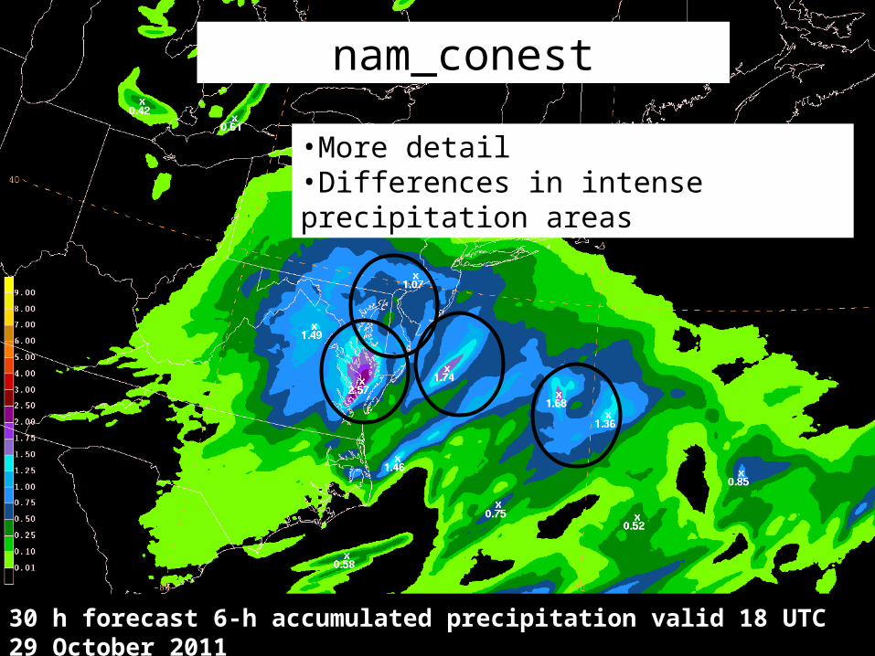
nam_conest
30 h forecast 6-h accumulated precipitation valid 18 UTC 29 October 2011
•More detail•Differences in intense precipitation areas

nam_firewx
30 h forecast 6-h accumulated precipitation valid 18 UTC 29 October 2011
•Downscaling of the nest

RFC Stage IV QPE
6-h accumulated precipitation ending 18 UTC 29 October 2011

10
nam12
24 h forecast 24-h accumulated precipitation valid 12 UTC 9 Nov 2011

11
Nam_conest
24 h forecast 24-h accumulated precipitation valid 12 UTC 9 Nov 2011

12
RFC Stage IV QPE
24-h accumulated precipitation ending 12 UTC 9 November 2011

13
Native Model Differences Summary
•nam12 and nam_conest can be quite different for precipitation
-Likely mostly due to the limited use of convective parameterization on the 4 km nest and the higher resolution.
•Smaller differences in mass fields (heights, temps, etc)
•FireWx Nest is mostly a downscaling of the 4 km CONUS Nest

14
Display Resolution Differences•NCO provides NAM data with variety of domains/resolutions.
Model Display Resolution NMAP name
12 km Parent Domain
80 km nam
12 km Parent Domain
40 km nam40
12 km Parent Domain
20 km nam12_20
12 km Parent Domain
12 km nam12
4 km CONUS Nest 4 km nam_conest

15
80 km

16
40 km

17
12 km

18
4 km CONUS Nest

19
NSSL QPE
20
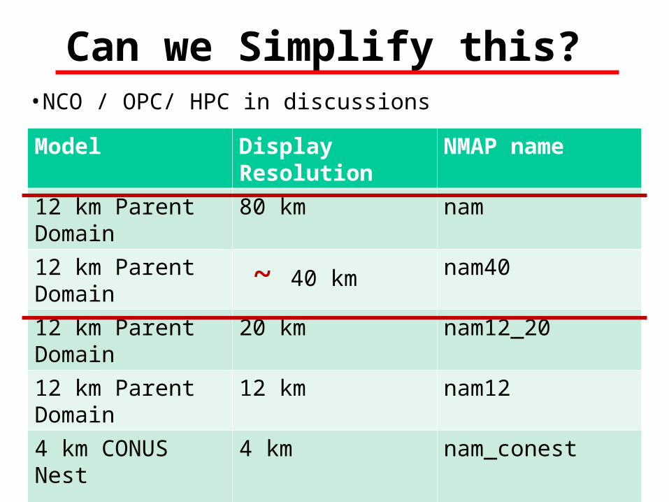
Can we Simplify this?•NCO / OPC/ HPC in discussions
Model Display Resolution NMAP name
12 km Parent Domain
80 km nam
12 km Parent Domain
~ 40 km nam40
12 km Parent Domain
20 km nam12_20
12 km Parent Domain
12 km nam12
4 km CONUS Nest 4 km nam_conest

18Z
06Z
00Z12Z
00Z,12Z
06Z,18Z
HiResWindow Runs ≠ CONUS Nest•Different model cores (WRF-NMM/ WRF-ARW vs. NMMB)
•Smaller domains
•Arrive later in the cycle
•Forecasts only to 48 h
•Can be preempted by hurricane runs

22
Summary
Know what you are looking at
Native model differences
Display resolution differences
NMAP naming conventions
Are your spf’s updated?-Take advantage of new data
Questions, feedback, & ideas welcome!