1 Soil Classification Prof Neelam Belani Assistant Professor, Civil Engineering Department IT,NU.
41
1 Soil Classification Prof Neelam Belani Assistant Professor, Civil Engineering Department IT,NU.
-
Upload
leslie-sparks -
Category
Documents
-
view
218 -
download
0
Transcript of 1 Soil Classification Prof Neelam Belani Assistant Professor, Civil Engineering Department IT,NU.

Soil Classification
Prof Neelam BelaniAssistant Professor, Civil Engineering
DepartmentIT,NU.

Objectives
To develop a systematic way to describe and classify soils;
To assign symbols.
To group soils of similar geotechnical characteristics; and
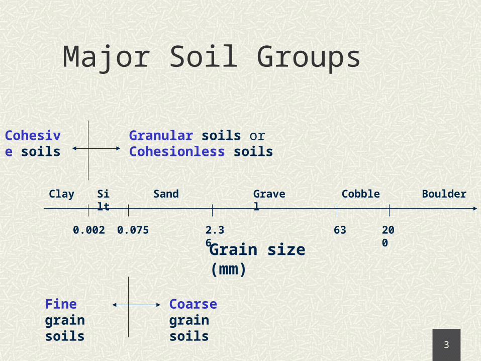
Major Soil Groups
0.002 200632.360.075
Grain size (mm)
BoulderClay Silt Sand Gravel Cobble
Fine grain soils
Coarse grain soils
Granular soils or Cohesionless soils
Cohesive soils

Grain Size Distribution
To know the relative proportions of different grain sizes.
An important factor influencing the geotechnical characteristics of a coarse grain soil.
Not important in fine grain soils.
Significance of GSD:

Grain Size Distribution
In coarse grain soils …... By sieve analysis
Determination of GSD:
In fine grain soils …... By hydrometer analysis
Sieve Analysis Hydrometer Analysis
soil/water suspension
hydrometer
stack of sieves
sieve shaker

Grain Size Distribution Curve
can find % of gravels, sands, fines
define D10, D30, D60.. as above.
0
20
40
60
80
100
0.001 0.01 0.1 1 10
Grain size (mm)
D30
sievehydrometer
D10 = 0.013 mmD30 = 0.47 mmD60 = 7.4 mm
sands gravelsfines
% P
assi
ng

Well or Poorly Graded Soils
Well Graded Soils Poorly Graded Soils
Wide range of grain sizes present
Gravels: Cc = 1-3 & Cu >4
Sands: Cc = 1-3 & Cu >6
Others, including two special cases:
(a) Uniform soils – grains of same size
(b) Gap graded soils – no grains in a specific size range
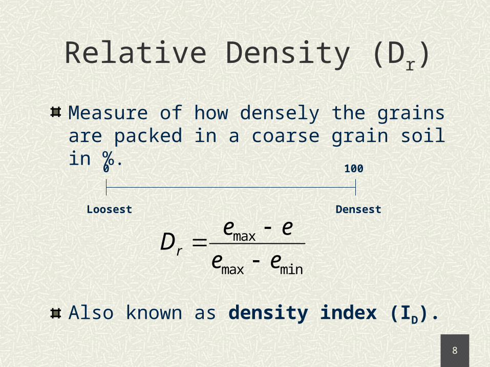
Relative Density (Dr)
Measure of how densely the grains are packed in a coarse grain soil in %.
0 100
Loosest Densest
minmax
max
ee
eeDr
Also known as density index (ID).

Granular Soil Consistencies
As per AS1726 - 1993
Relative Density (%) Consistency Term
0-15
15-35
35-65
65-85
85-100
Very loose
Loose
Medium dense
Dense
Very dense

Atterberg Limits
Border line water contents, separating the different states of a fine grained soil
Liquidlimit
Shrinkagelimit
Plasticlimit
0water content
liquidsemi-solid
brittle-solid
plastic

Atterberg Limits
Liquid Limit (wL or LL):
Clay flows like liquid when w > LL
Plastic Limit (wP or PL):
Lowest water content where the clay is still plastic
Shrinkage Limit (wS or SL):
At w<SL, no volume reduction on drying

Plasticity Index (PI)
Range of water content over which the soil remains plastic
Liquidlimit
Shrinkagelimit
Plasticlimit
0water content
plastic
Plasticity Index = Liquid Limit – Plastic Limit

Classifying Fines
Purely based on LL and PI
20 100500
20
0
40
60
Liquid Limit
Liqu
id L
imit
A-Line
PI=0.73(LL-20)
Silts
Clays
High plasticity
Low plasticity
35
Intermediate plasticity

IS 1726 – 1993 Classification
0 5 12 50 100
% of fines
fine grain soilscoarse grain soils
X: Coarse
G = Gravel
S = Sands
Y: Fines
M = Silts
C = Clays
A: Gradation
W = well graded
P = poorly graded
B: Plasticity
H = LL > 50
I = 35 < LL < 50
L = LL < 35
XA
e.g., GP
YB
e.g., CHXY
e.g., SM
XA-XY
e.g., GP-GC

Summary
Sieve analysis – for coarse grain soils Hydrometer analysis - for fine grain soils
Classify coarse by GSD and fines by Atterberg limits (PI-LL
chart)
.

16
Classification of Soils

17U.S. Army Corps of Engineers (Triangular Chart Classification, 1943)

18
Arthur CasagrandeBorn: August 28, 1902
Migrated to US in US, as research assistant at Bureau of Public Roads, with Karl Terzaghi at M. I. T.
Worked on soil classification, shear test and frost action on soil
Initiated soil mechanics at Harvard University, 1932

19

20

21

22

23

24

25

26

27

28

29

30

31

32

33
34

35

36

37

38

39

40

41