1 OVERVIEW OF LANDSCAPE VISUALIZATION. 2 Definitions/scope History of visualisation media Case...
67
1 OVERVIEW OF LANDSCAPE VISUALIZATION
-
date post
22-Dec-2015 -
Category
Documents
-
view
218 -
download
1
Transcript of 1 OVERVIEW OF LANDSCAPE VISUALIZATION. 2 Definitions/scope History of visualisation media Case...

1
OVERVIEW OF LANDSCAPE VISUALIZATION
OVERVIEW OF LANDSCAPE VISUALIZATION

2
OVERVIEW OF LANDSCAPE VISUALIZATION
OVERVIEW OF LANDSCAPE VISUALIZATION
• Definitions/scope• History of visualisation media• Case Studies• Discussion• Criteria and proto-principles for visualisation

3
SOME DEFINITIONS
– Data visualization (scientific visualization): numerical, chart, 2D mapping, or 3D data in an enhanced but abstract form
– Landscape visualization which displays terrain and other recognisable geographic features in perspective view, with varying degrees of “realism” (Visual Simulation)

4
Landscape TypesFarmingSuburbanRuralTreedLowland ForestScrub
Site BoundaryLandscape Types
FarmingSuburbanRuralTreedLowland ForestScrub
Site Boundary
CONCEPTUAL INFORMATION

UBC/Alex Fraser Research ForestShelterwood Systems
Actual Situation
Composition50% Fdi, 50% Pli
Composition50% Pli, 50% Sx
Road
Lake
Longitudinal SectionHeight:Fdi=34-36mPli=29-30m Height:
Pli=29-30mSx=35-36m
In the futureThe height of the trees at:20 years: Fdi=4-5m, Sx=2m, Pli=5-6m40 years: Fdi=14-15m,Sx=12-13m, Pli=17-18mThe composition of the stand is supposed to be the same.

6
EXPERIENTIAL INFORMATION

7
Applications to VRM
• Project planning/design
• Visual impact assessment
• Public information/communication
• Perception testing
• Documentation for post-construction monitoring

8
Development review: alternative housing options

9
Information processing
• Stimulus
• Channel
• Receptor
• Response

10

11
Simulation components (Appleyard)
• Information-storage system (data)
• Simulation medium (technique)
• Presentation format– Images– Setting– Additional information
• People (operators)and….

12
HISTORY

13
• Photo Montage• Image Draping• 2D/3D Hybrid Modeling• 3D Modeling• Animation• Immersion/Interactivity
VISUALIZATION MEDIA

14
• Geometric 3D Modelling: eg. wire-frames, solid models
• Photo-imaging: eg. 2D “paint programs” used on scanned photographs
• Hybrid Geometric/Photo-imaging: eg. composite pictures and draped images (texture maps)
ESTABLISHED TYPES OF LANDSCAPE VISUALIZATION


16

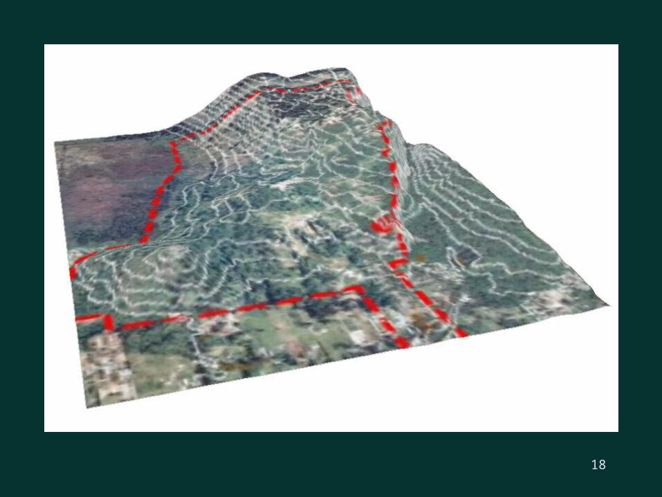
SIMULATED SHELTERWOOD-CUTS (THIRD ENTRY)
Photosimulation
18

SIMULATED SHELTERWOOD CUTS(Photo-overlay of 3D canopy model)

20EXISTING VIEW (PHOTOGRAPH)

PHOTOSIMULATION (3D STUDIO/PHOTO-SHOP)

World Construction Set Visualization

23
Full 3D Modelling

24
ESTABLISHED VISUALIZATION TYPES
• Photo-realism is not new
• Allow temporal “snapshots”
• Inexpensive and in fairly common use
• Very powerful images

25
LIMITATIONS OF ESTABLISHED SIMULATIONS
• Static windows offer a tiny slice of the information: viewpoint easily manipulated
• Single set of conditions usually depicted
• Many choices and assumptions must be made to get to a “realistic” image, with little guidance other than experience

26
NEW TYPES OF VISUALIZATION
• Newer presentation formats: eg. computer animation, virtual reality– Dynamism: movement, growth (spatial and
temporal variation)– Real-time interactivity and querying – Immersion technology adds new dimensions to
“reality”
• Increasingly “automated” realism tools/databases

27
EXAMPLES OF EMERGING VISUALIZATION TYPES

28

29


31

32
Computer animation

33
UBC LANDSCAPE IMMERSION LAB (LIL)

34
Goals for visualisation
• Get ‘em in the door and keep ‘em interested
• Make sure they understand what they see
• Make sure they can trust the visualisations
• Make sure they are not misled!

35
CONCLUSIONS
• Visualizations are becoming an ever more valuable and powerful decision support tool, but….
• They should be used judiciously:
We do not yet know when to trust them

36
Discussion questions
1How might a computer image or scene be manipulated to make it more aesthetic?
2Do the newer virtual reality techniques make it easier or harder to expose bias in visualization?
3What criteria or guidelines would you propose for the appropriate use of visualisations in a VRM context?

37
PRINCIPLES FOR PREPARING VISUALISATIONS
• Realistic
• Accurate
• Comprehensible
• Engaging
• Credible/legitimate
• Accessible

38
Understandable images

39
Representative views

40
Representative views

41
Accuracy

42

43

44
Potential advantages of emerging visualization methods
• Much more comprehensive choice of viewing modes
• Continuous shifts in time and space (seeing the transitions)
• Transparency of the process: freedom to roam within the data (querying the picture?)
• Much more efficient generation of multiple realistic images
• High-tech image for the presenter

45
Limitations of emerging visualizations
• Insufficient data for high realism• Most are not linked directly to predictive
models (eg. ecological).• Still numerous choices and assumptions to be
made by the “artist”, with minimal guidance and no training
• Little available knowledge of the effects of visual images on viewer response: how many images and how much realism do we need?

46
Risks of emerging visualization methods
• The “wow” factor and the “anti-wow” factor
• Very real danger of over-use, inappropriate use, and deliberately biased use

47

48
ALTERNATIVE VISUALIZATION TECHNIQUES

49
Some proto-principles
• Visualizations should be clear and understandable to the viewer
• Visualizations should be representative of typical or informative views
• Visualizations should be accurate on features important to the decision being made
• Realistic visualizations should evoke the same reactions as would the corresponding real environment (response equivalence)

50
Some proto-principles
• Different visualization types are suited for different purposes: choose carefully and use multiple visualisation “channels”
• Maximize the freedom of choice for the viewer
• Make the visualization process and data sources transparent and accessible
• Maximize the linkages to the real landscape/experience/context

51
TEMPORAL VISUALISATION:FIRST ENTRY SHELTERWOOD CUTS

52
THIRD ENTRY SHELTERWOOD CUTS

53
FIFTH ENTRY SHELTERWOOD CUTS

54

55

56
Angle of view

57
Geothermal powerplant
Predictive simulation

58
Geothermal powerplant
Predictive simulation Actual photograph as built

59

60

61

62

63

64

65

66
THE PROMISE OF VISUALIZATION
• Improved communication and understanding of
complex information: bringing 2D polygon maps
to life, revealing long-term temporal change,
showing future communities
• Integrating information across disciplines and
cultural barriers
• Helping designers/researchers to understand
their own plans/models better

67
Simulation components (Appleyard)
• Information-storage system (data)
• Simulation medium (technique)
• Presentation format– Images– Setting– Additional information