1 of 141 [email protected] Sergio Masuelli November 2010 Fortaleza Brasil System Engineer...
27
1 of 141 [email protected] r Sergio Masuelli November 2010 Fortaleza Brasil System Engineer of SAC-D Geophysical Applications for MWR Professor of Gulich Institute (CONAE-UNC)
-
Upload
brenna-garey -
Category
Documents
-
view
214 -
download
0
Transcript of 1 of 141 [email protected] Sergio Masuelli November 2010 Fortaleza Brasil System Engineer...

1 of 141
Sergio Masuelli
November 2010 Fortaleza Brasil
System Engineer of SAC-D Geophysical Applications for MWR
Professor of Gulich Institute (CONAE-UNC)

2 of 141
Index
1) Activities of Gulich Institute
2) Aearte Master
3) Introduction to MWR
4) L1 to L2 project plan
5) Surface retrievals
6) Atmospheric Retrievals
7) Sea Ice Concentration
8) L2 Simulator

3 of 141
GULICH INSTITUTE
CETT
SAC-C
MOC
Instituto
Gulich

4 of 141
GULICH INSTITUTE
Instituto de Altos Estudios Espaciales Mario GulichCONAE-UNC
Natural Emergencies:
National Emergencies Services
•Images supply
•Users support
Courses:
•Non Qualified Users
•National Courses (INTA, 2004)
•International Charter (Regional PM, 2006)
Activities began in 2001
Health Applications:
•Scientific Support to Health Authorities
•Landscape study of vector dynamic.
•Spatial Modelling of vector dynamic.
•Regional Courses (Latinoamérica, 2006)

5 of 141
ρ = Densidad de mosquitos DR = tensor de DifusiónDW = Tensor de Rugosidad V = Velicidad Viento SuperficieKH = Tensor de Atracción H = Campo de Atracción = Tasa de nacimientos β = Tasa de muertes
Modelado espacio-temporal de la densidad de Culicidos en escenarios heterogéneos derivados de información de sensores remotos.
S. Masuelli, C. H. Rotela, M. Lamfri, C.M. Scavuzzo
,R W
H
P tD D V
tK H
OránOrán
La Ecuación representa el modelo básico de difusión. El primer término representa la difusión, el segundo el transporte por el viento y el tercero la atracción por mamíferos (humanos). La ultima corresponde a los términos Fuente y Sumidero.
6 of 141
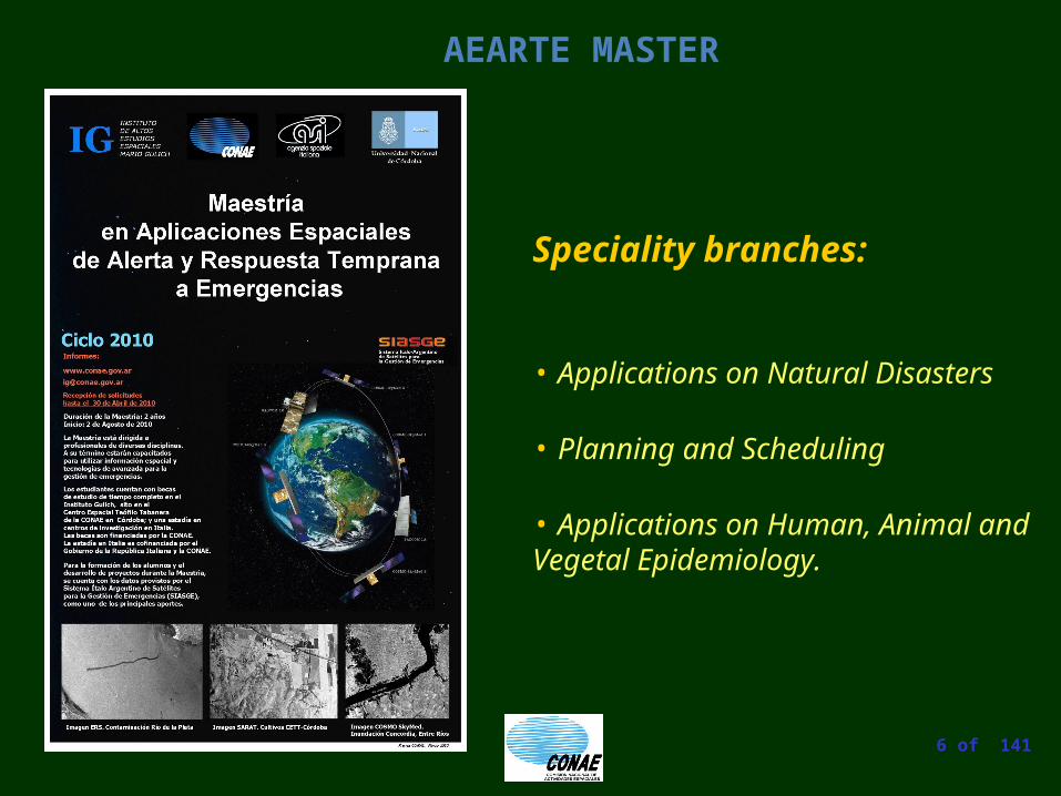
AEARTE MASTER
Speciality branches:
• Applications on Natural Disasters
• Planning and Scheduling
• Applications on Human, Animal and Vegetal Epidemiology.

7 of 141
AEARTE MASTER
OBJECTIVES
To specialize professionals for the interdisciplinary managing of Emergencies by doing effective use of space technologies, geoprocessing and AI P&S technologies.
To promote research related to the factors originating natural Disasters including buds of agricultural, animal or human plagues. This would allow preparing strategies of Emergency prevention, monitoring, control and response .
To make possible the application of the most modern technologies to the aims of gathering, summarize, analysis and diffusion of data.

8 of 141
Introduction to MWR

9 of 141
•MWR swath width is ~380km, displaced 272km across-track (towards the right), wich overlaps the Aquarius instrument swath.
•MWR IFOV ~40km
Introduction to MWR

10 of 141
Conical Arc
Conical Arc
SUN
Introduction to MWR

11 of 141
Introduction to MWR
MWR beam overlapping along track
40 km
13 km
3 times

12 of 141
Objective:
To obtain the Geophysical Variables
WS: Wind Speed
Surface: WD: Wind Direction
IC: Ice Concentration
WV: Water Vapor
Atmosphere: LWC: Liquid Water Content
RW: Rain Water
Introduction to MWR

13 of 141
Introduction to MWR
Schematic Microwave Radiative Transfer Model [Thompson, 2004].
Up-welling Brightness
Atmospheric Emission
Surface Emission
Down-welling Brightness
Reflected Atmospheric Brightness
Microwave Antenna
Atmospheric Absorption
Radiative Transfer Model

14 of 141
Introduction to MWR
Pi Gi TB*i where TB*iP01,…, Pi ,…, P0
N
We have 6 Ps but only 4 TBs
TBj F Pj Forward problem
P G TB Inverse problem
Geophysical Variables P: WS, WD, IC, WV, LWC, RW
The Retrieval Problem
?

15 of 141
L1 to L2 project plan
ATBD
Simulators
Depuration of Algorithms
Application Prototype Calibration Prototype
General Scheme of the Development Plan

16 of 141
Surface retrievals
Insensitive on atmospheric
changes
Wind Retrieval. AVH Algorithm
A(WS,SST,f)TBH
TBV
F0(SST)
(ATBV − TBH ) - F(SST) = C0(WS)+C1(WS)COS(χ)+C2(WS)COS(2χ)
Does C’S
converge?
F(SST) = (ATBV − TBH) − [C0(WS)+C1(WS)COS(χ)+ C2(WS)COS(2χ)]
No
Yes
END
(ATBV − TBH ) - F(SST) - C0(WS)
=C1(WS)COS(χ)+C2(WS)COS(2χ)

17 of 141
Surface retrievals
WindSat EDR wind speed
Truth wind speed , m/s
EDR
win
d sp
eed,
m/s
0 5 10 15 200
2
4
6
8
10
12
14
16
18
20
ED
R W
ind
Spe
ed, m
/s
Wind Speed CFRSL Preliminary Results (AVH)
"AV-H" wind speed ret.
Truth wind speed, m/s
"AV-
H" w
ind
spee
d, m
/s
0 5 10 15 200
2
4
6
8
10
12
14
16
18
20
AV
H W
ind
Spe
ed, m
/s

18 of 141
WindSat wind direction ret.
Truth wind direction, degree
Win
dSat
win
d di
rect
ion,
deg
ree
0 50 100 150 200 250 300 3500
50
100
150
200
250
300
350
Surface retrievals
"AV-H" wind direction ret.
Truth wind direction, degree
"AV-
H" w
ind
dire
ctio
n, d
egre
e
0 50 100 150 200 250 300 3500
50
100
150
200
250
300
350
AV
H W
ind
Dir
ecti
on, d
egre
e
Wind Direction CFRSL Preliminary Results (AVH)
AV
H W
ind
Dir
ecti
on, d
egre
e

19 of 141
Atmospheric retrievals
The
Cloud
Problem

20 of 141
Atmospheric retrievals
Precipitation and LWC signal (CFRSL)

21 of 141
Atmospheric retrievals
Non Precipitative
Cloud
Rainy Cell
Rain and Cloud Analysis

22 of 141
Sea Ice Concentration
Bootstrap Algorithm
Nasa Team Algorithm
100 % FY ice boundary
100 % MY ice boundary
50% Ice Concboundary
100% Ice Concboundary
100 % FY ice boundary
100 % MY ice boundary
50% Ice Concboundary
100% Ice Concboundary
Sea Ice Algorithms

23 of 141
Sea Ice Concentration
WindSat: 19V & 37V GHz
MWR 24V & 37V GHz
Longitude, (deg.)
MWRSimulated
Latit
ude,
(de
g.)
Latit
ude,
(de
g.)
WindSat
First Year Ice Concentration using NT algorithm (CFRSL)

24 of 141
Sea Ice Concentration
37
(37) (37)
(37) (37)
V HB B
V HB B
T TPR
T T
24/37
(24) (37)
(24) (37)
H HB B
H HB B
T TGR
T T
CONAE Sea Ice Algorithm

25 of 141
Sea Ice Concentration
Obtaining Parameters from a Scatter Plot

26 of 141
L2 Simulator
External Data Preparation
GDAS
Internal Data Preparation
RTM
Data Base
IC/WS/WD
END
L2 Processor
It converges?No
Yes
WV/LWC/RW
Data Base
L1B1
RTM

27 of 141
Fin
We have a lot of work to do…..