1. INTRODUCTION AND EXPLANATORY · PDF file1. INTRODUCTION AND EXPLANATORY NOTES Shipboard...
9
1. INTRODUCTION AND EXPLANATORY NOTES Shipboard Scientific Party 1 SCIENTIFIC GOALS Four quite separate scientific problems faced us on Leg 22: (1) to find out the age and mode of formation of the Whafton Basin, (2) to obtain a detailed stratigraphic and biostratigraphic sequence on and to either side of the Ninetyeast Ridge, (3) to determine the mode of formation of the Ninetyeast Ridge, and (4) to date two of the three major unconformities in the Bengal Fan. To accomplish these goals the ship sailed from Darwin to Colombo with a plan to drill from 8 to 10 holes. Wharton Basin The discovery of many distinctive patterns of magnetic anomalies in the Indian Ocean had enabled McKenzie and Sclater (1971) to reconstruct the position of the southern continents back to the Late Cretaceous (Figure lb, lc). However, distinctive anomalies have not been recognized in the deeper portions of the Indian Ocean, in particular, the Wharton Basin east of Ninetyeast Ridge. This absence of information, combined with the complex geometry of the continents in the Late Cretaceous, make it impossible to produce exact reconstructions of the continents using only present sea floor evidence. In the classical reconstructions of Gondwanaland one of the major problems is the relative positions of India, Australia, and Antarctica. Smith and Hallam (1970) (Figure Id) have demonstrated that the best geometrical fit of the continents at the 500 fathom contour is close to King's (1950) reconstruction as modified from DuToit (1937). In this geometry India abuts the northwestern flank of Antarctica, and there is a gap between northeastern India and Australia. Ahmad (1961), Crawford (1969), and Veevers et al. (1971) all prefer a reconstruction in which India is placed against northwest Australia. This fit is geometrically acceptable, but in this position the India Australia Antarctica combination cannot be fitted against the Africa South America group without leaving large gaps between them. No overriding reasons exist for believing Gondwanaland to be one supercontinent, but as Smith and Hallam (1970) have pointed out, the stratigraphic unit of the Gondwana formations is evidence 1 C. C. von der Borch, Flinders University, Bedford Park, South Australia; J. G. Sclater, Scripps Institution of Oceanography, La Jolla, California; S. Gartner, Jr., Rosenstiel School of Marine and Atmospheric Science, University of Miami, Coral Gables, Florida; R. Hekinian, Centre Oceanologique de Bretagne, Brest, France; D. A. Johnson, Woods Hole Oceanographic Institution, Woods Hole, Massachusetts; B. McGowran, University of Adelaide, Adelaide, South Australia; A. C. Pimm, Scripps Institution of Oceanography; La Jolla, California; R. W. Thompson, Humboldt State College, Arcata, California; J. J. Veevers, Macquarie University, North Ryde, N.S.W., Australia; Lee S. Waterman, Woods Hole Oceanographic In stitution, Woods Hole, Massachusetts. that all the fragments may at one time have been a single continent with few intervening gaps. The key to the relative and changing positions of India and Australia may lie in the ocean floor between them. This sea floor area includes the Bengal Fan, the central Indian Basin, the Ninetyeast Ridge, and the Wharton Basin. The Bengal Fan and the central Indian Basin to the south have prominent east west magnetic anomalies that constrain the position of India relative to Antarctica (cf. McKenzie and Sclater, 1971). The Ninetyeast Ridge marks a transform fault along which India migrated northward during the Late Cretaceous and early Tertiary (McKenzie and Sclater, 1971). Only the history of the Wharton Basin is unknown, and thus the understanding of this basin may hold the key to the resolution of the relative movements of the three continents, India, Australia, and Antarctica, since upper Mesozoic times. Dietz and Holden (1971) arguing from the fit of Smith and Hallam (1970), have suggested that this basin may be pre Mesozoic in age. Distinctive magnetic anomalies have been recognized in the western portion of the Wharton Basin between the Ninetyeast Ridge and the Cocos Keeling Ridge complex (Sclater and Fisher, in press). These anomalies become younger to the north and have been identified as 23 just south of the Java trench and 33 just north of a prominent bulge in the Ninetyeast Ridge at 20° S. Tentative identification has also been made of Anomalies 31 through 33 in the deep basin south of the Cocos Keeling Ridge complex. East west trending anomalies were located at the site survey 22 3a at 8°3θ'S and 97°E and in the Argo Abyssal Plain (Falvey, 1972). All recognizable anomalies north of 20°S and west of 110°E trend east west and provide evidence that the basin was formed by an east west trending ridge which spread north south. The depth of the Wharton Basin is generally below 5000 meters except for a region around Cocos Keeling Island and an area including Christmas Island. From the Java trench to 20°S, the depth in general increases with increasing distance from the trench. This increase is not uniform and many prominent north south gashes offsetting topography of different depths are shown in the Russian bathymetric chart of the area (Belousov et al., 1962). The magnetics and topography in the basin are interpreted in the following manner: 1) The Wharton Basin is between 55 m.y.B.P. and 100 or perhaps 120 m.y.BJP. old. 2) The crust gets progressively older going southward from the trench. 3) The Wharton Deep may be 100 to 120 m.y. old. 4) The east west magnetic lineations and general nonuniformity of the topography are evidence that the basin has been formed by an east west trending ridge offset by many north south fracture zones, the three major ones being at 95°E, 98°E, and 105°E. The first two have a
Transcript of 1. INTRODUCTION AND EXPLANATORY · PDF file1. INTRODUCTION AND EXPLANATORY NOTES Shipboard...
1. INTRODUCTION AND EXPLANATORY NOTES
Shipboard Scientific Party1
SCIENTIFIC GOALS
Four quite separate scientific problems faced us on Leg22: (1) to find out the age and mode of formation of theWhafton Basin, (2) to obtain a detailed stratigraphic andbiostratigraphic sequence on and to either side of theNinetyeast Ridge, (3) to determine the mode of formationof the Ninetyeast Ridge, and (4) to date two of the threemajor unconformities in the Bengal Fan. To accomplishthese goals the ship sailed from Darwin to Colombo with aplan to drill from 8 to 10 holes.
Wharton Basin
The discovery of many distinctive patterns of magneticanomalies in the Indian Ocean had enabled McKenzie andSclater (1971) to reconstruct the position of the southerncontinents back to the Late Cretaceous (Figure lb, lc).However, distinctive anomalies have not been recognized inthe deeper portions of the Indian Ocean, in particular, theWharton Basin east of Ninetyeast Ridge. This absence ofinformation, combined with the complex geometry of thecontinents in the Late Cretaceous, make it impossible toproduce exact reconstructions of the continents using onlypresent sea-floor evidence.
In the classical reconstructions of Gondwanaland one ofthe major problems is the relative positions of India,Australia, and Antarctica. Smith and Hallam (1970) (FigureId) have demonstrated that the best geometrical fit of thecontinents at the 500-fathom contour is close to King's(1950) reconstruction as modified from DuToit (1937). Inthis geometry India abuts the northwestern flank ofAntarctica, and there is a gap between northeastern Indiaand Australia. Ahmad (1961), Crawford (1969), andVeevers et al. (1971) all prefer a reconstruction in whichIndia is placed against northwest Australia. This fit isgeometrically acceptable, but in this position theIndia-Australia-Antarctica combination cannot be fittedagainst the Africa-South America group without leavinglarge gaps between them. No overriding reasons exist forbelieving Gondwanaland to be one supercontinent, but asSmith and Hallam (1970) have pointed out, thestratigraphic unit of the Gondwana formations is evidence
1 C. C. von der Borch, Flinders University, Bedford Park, SouthAustralia; J. G. Sclater, Scripps Institution of Oceanography, LaJolla, California; S. Gartner, Jr., Rosenstiel School of Marine andAtmospheric Science, University of Miami, Coral Gables, Florida;R. Hekinian, Centre Oceanologique de Bretagne, Brest, France; D. A.Johnson, Woods Hole Oceanographic Institution, Woods Hole,Massachusetts; B. McGowran, University of Adelaide, Adelaide,South Australia; A. C. Pimm, Scripps Institution of Oceanography;La Jolla, California; R. W. Thompson, Humboldt State College,Arcata, California; J. J. Veevers, Macquarie University, North Ryde,N.S.W., Australia; Lee S. Waterman, Woods Hole Oceanographic In-stitution, Woods Hole, Massachusetts.
that all the fragments may at one time have been a singlecontinent with few intervening gaps.
The key to the relative and changing positions of Indiaand Australia may lie in the ocean floor between them. Thissea-floor area includes the Bengal Fan, the central IndianBasin, the Ninetyeast Ridge, and the Wharton Basin. TheBengal Fan and the central Indian Basin to the south haveprominent east-west magnetic anomalies that constrain theposition of India relative to Antarctica (cf. McKenzie andSclater, 1971). The Ninetyeast Ridge marks a transformfault along which India migrated northward during the LateCretaceous and early Tertiary (McKenzie and Sclater,1971). Only the history of the Wharton Basin is unknown,and thus the understanding of this basin may hold the keyto the resolution of the relative movements of the threecontinents, India, Australia, and Antarctica, since upperMesozoic times. Dietz and Holden (1971) arguing from thefit of Smith and Hallam (1970), have suggested that thisbasin may be pre-Mesozoic in age.
Distinctive magnetic anomalies have been recognized inthe western portion of the Wharton Basin between theNinetyeast Ridge and the Cocos-Keeling Ridge complex(Sclater and Fisher, in press). These anomalies becomeyounger to the north and have been identified as 23 justsouth of the Java trench and 33 just north of a prominentbulge in the Ninetyeast Ridge at 20° S. Tentativeidentification has also been made of Anomalies 31 through33 in the deep basin south of the Cocos-Keeling Ridgecomplex. East-west-trending anomalies were located at thesite survey 22-3a at 8°3θ'S and 97°E and in the ArgoAbyssal Plain (Falvey, 1972). All recognizable anomaliesnorth of 20°S and west of 110°E trend east-west andprovide evidence that the basin was formed by aneast-west-trending ridge which spread north-south.
The depth of the Wharton Basin is generally below 5000meters except for a region around Cocos-Keeling Island andan area including Christmas Island. From the Java trench to20°S, the depth in general increases with increasing distancefrom the trench. This increase is not uniform and manyprominent north-south gashes offsetting topography ofdifferent depths are shown in the Russian bathymetricchart of the area (Belousov et al., 1962).
The magnetics and topography in the basin areinterpreted in the following manner:
1) The Wharton Basin is between 55 m.y.B.P. and 100or perhaps 120 m.y.BJP. old.
2) The crust gets progressively older going southwardfrom the trench.
3) The Wharton Deep may be 100 to 120 m.y. old.4) The east-west magnetic lineations and general
nonuniformity of the topography are evidence that thebasin has been formed by an east-west-trending ridge offsetby many north-south fracture zones, the three major onesbeing at 95°E, 98°E, and 105°E. The first two have a

INTRODUCTION
Figure 1. Lambert equal area projection of various reconstructions of the southern continents after Laughton et al, 1970.(a) present, (b) 35 m.y.B.P. reconstruction after McKenzie and Sclater (1971), (c) 75 m.y.B.P. reconstruction afterMcKenzie and Sclater (1971), (d) Jurassic reconstruction after Smith and Hallam (1970.
northward offset of roughly 500 km each and the third asoutherly offset of almost the same amount.
5) The tectonic history of the Wharton Basin iscomplicated by the Cocos-Keeling complex and the bulge inthe topography produced by the viscoelastic bulging of theplate as it descends into the trenth.
The Wharton Basin is thought to be younger than theEarly Cretaceous. Unless spreading was very slow in theCretaceous, almost all the present oceanic crust betweenIndia and Australia has been formed since this time.
Magnetic anomalies south of Ceylon and north of CrozetIsland define the exact relationship of India to Antarcticain the Late Cretaceous (Figure lc from Laughton et al.,1972). They place India due west of Australia, separatedfrom it by the Wharton Basin, Broken Ridge, and KerguelenPlateau. With the east-west-trending anomalies recognizedin the Wharton Basin by Sclater and Fisher (in press) it isdifficult to see how India would be connected to Australiaexcept by east-wesj; spreading before the Cretaceous.However, such spreading would take India across the
INTRODUCTION
continental Kergùelen Plateau and Broken Ridge and,hence, is unlikely. Thus, this tentative interpretation of theWharton Basin argues against fitting India close to westernAustralia and is rather weak evidence in favor of theposition of India given by Smith ahd Hallam (1970).
Three Deep Sea Drilling sites in the Wharton Basin werechosen to test the proposed tectonic history of the basinand also to help date the oceanic crust in the regions wherethere are no distinctive magnetic anomalies. These siteswere chosen in a triangle, with Site 211 on the ridge justsouth of the trench, Site 212 some 12° due south of thefirst site in the deepest part of the basin, and Site 213parallel in latitude and some 17° to the east of the first sitein the zone of distinctive magnetic anomalies which occursjust east of the Ninetyeast Ridge.
East-West Drilling Transect of the Ninetyeast Ridge
Among the most prominent features of the Indian Oceanare the numerous micro continents and ridges not directlyconnected with active spreading centers. One such feature isthe long, north-south-trending Ninetyeast Ridge whichalmost exactly marks the 90 degree east longitude.Tectonically, this ridge is thought to have been a majorfracture zone in Late Cretaceous and early Tertiary times,marking the northward movement of India relative to aonce-joined Antarctica and Australia. At the breakup ofAustralia and Antarctica the spreading direction in theIndian Ocean changed. McKenzie and Sclater (1971)tentatively suggested that the Ninetyeast Ridge was formedat this time by slow compression, the ridge having remainedelevated ever since.
Outcropping Cretaceous and Tertiary calcareous materialhas been dredged and cored from the crest and flanks of theridge (Funnell, 1971; Riedel, 1971). From this evidence itis presumed that the ridge has been above the carbonatecompensation depth during much of the Tertiary.
Some important differences in depositional environmentmay have existed in the two basins on either side of theNinetyeast Ridge. The Wharton Basin may be open to DeepAntarctic Bottom Water through the gap betweenNaturaliste and Broken ridges and via a deep fracture zoneacross the India-Australia Ridge. This would explain thebottom water being consistently colder to the east of theNinetyeast Ridge. Both basins were formed by ridgesspreading north-south, and anomaly 28 is found at the samelatitude either side of its ridge. However, the Wharton Basinis the deeper of the two and the spreading axis was to thenorth, whereas in the central Indian Basin the axis was tothe south. Tectonically, the Ninetyeast Ridge was a fracturezone which was active through the Cretaceous untilanomaly 21 time. At this time or some time later the ridgein the Wharton Basin jumped further south to become acontinuation of the ridge in the central Indian Ocean andbegan to separate Australia from Antarctica. At this time allmotion on the Ninetyeast Ridge ceased. If this tectonicpicture is correct, then sediment younger than anomaly 21time 50 m.y.B.P. (early Eocene) should have exactly thesame paleohistory on both sides of the ridge. On the otherhand, if the Wharton Basin has remained fixed to Australia,older sediments in this basin would have remained more orless stationary during the period 50-75 m.y.B.P. while those
in the central Indian Basin may have experienced as muchas 25° of northward migration.
On Leg 22 it was decided to drill sites both on and toeither side of the Ninetyeast Ridge south of the turbiditesediments from the Bengal and Nicobar fans. The firstobjective of these sites was to compare the biostratigraphicrecord on both sides of the ridge at the same latitude. Asecondary objective was to obtain basement ages at all threesites and to examine the older sediments for evidence ofradically different latitudes of formation.
Sites on the Ninetyeast Ridge
The third major objective of Leg 22 was to gain a betterunderstanding of the past tectonic history of the NinetyeastRidge. For this purpose two or possibly three sites wereplanned. Distinctive east-west-trending magnetic anomalies23 through 32 have been identified on either side of theNinetyeast Ridge. On the west these anomalies get oldernorthwards; to the east they increase in age to the south.The anomalies thus indicate that the Ninetyeast Ridge wasan active transform fault from the Late Cretaceous(anomaly 32) until at least the early Eocene (anomaly 23).After the Eocene, two portions of the oceanic crustcoalesced, India and Australia become part of the sameplate, and motion on the Ninetyeast Ridge ceased. Sincethis time the whole region from Pakistan in the northwestto Australia in the southeast has behaved as a rigid platemoving slowly northeast with respect to Antarctica.McKenzie and Sclater (1971) and Fisher et al. (1971) havesuggested that the Ninetyeast and Chagos Laccadive ridgeswere formed after the Eocene either by (a) slow extensionalong the old lines of weakness-the Chagos and Ninetyeasttransform faults, or by (b) compression related to thechange in spreading direction in the Eocene. The NinetyeastRidge has an asymmetrical bell shape with a pronouncedsharp drop to a long linear deep to the east (Sclater andFisher, in press). It is thought that this deep marks the oldtransform fault and that the crust to the west whichincludes the ridge proper has the same age as the old Indianplate. Unfortunately, most of the older portion of thisplate, north of 10°S, is covered by thick sections ofturbidite from the Bengal Fan. These sediments are toothick to drill through, and consequently, basement agecannot be obtained to extend the tectonic history ofMcKenzie and Sclater (1971) beyond anomaly 32 (75m.y.B.P.). Thus the Ninetyeast Ridge, provides the bestopportunity for determining the age of the older portionsof the plate. Such ages also should help to resolve theposition of India in the reconstructions of Gondwanaland.
The Ninetyeast Ridge also offered the possibility ofobtaining a complete biogenic calcareous and siliceoussection through most of the Cenozoic. Curray and Moore(1971) have suggested that the northern sections of theridge are covered by Miocene abyssal fan sediments whichwere uplifted during the Pliocene.
Two primary sites were planned on the ridge, thenorthernmost, in the region suggested by Curray and Moore(1971) at 8°N, was selected to date the second phase ofBengal Fan turbidites and to obtain an age for thebasement. A southern site on the ridge at 12°S was selectedfor a stratigraphic comparison with holes drilled close to

INTRODUCTION
the same latitude on either side of the ridge. A thirdpossibility at 2°N was considered and eventually drilled toprovide an additional biogenic section, to date the age ofthe Ninetyeast Ridge, and to obtain further informationregarding formation of the ridge.
Bengal Fan Sites
The Bengal Fan, purportedly the largest fan in theworld, is composed of sediments dumped into the head ofthe Bay of Bengal by the confluent Ganges andBrahmaputra rivers which drain the Himalayan MountainChain (Moore et al., 1971). Stratigraphy of the fan should,therefore, provide insight into the tectonic history of theHimalayas and thus the collision between the Indian andAsian plates.
From information gathered during two geological/geophysical expeditions to the Bengal Fan, Curray andMoore (1971) have correlated unconformities in the fanthroughout the entire Bay of Bengal. These unconformitieshave been related to pronounced and persistent velocitycontrasts as determined both by refraction and sonobuoywide-angle seismic reflection measurements. The strati-graphic ages of these unconformities were not determineddirectly, but the authors speculated that they maycorrespond to periods of major uplift of the Himalayas, onein late Miocene and one in Plio-Pleistocene times.
Two drilling sites (217 and 218) were proposed on andadjacent to the Bengal Fan to accomplish the followingspecific objectives:
1) To determine stratigraphic ages of the two majorunconformities;
2) To obtain sediments from the three main strati-graphic units defined by the unconformities, which werethought to represent pre-fan material, and two stage of fandeposits (Curray and Moore, 1971). Changes in provenanceof the detrital sediments might give an indication of thedevelopment and history of erosion of the Himalayas.
3) To provide information on the late history of theNinetyeast Ridge; and
4) To obtain samples for paleontologic and stratigraphiccontrol at this latitude in the northeastern Indian Ocean.
EXPLANATORY NOTES
Format and Authorship
This Initial Report (volume) is divided into three parts.Part I (Chapters 1-9) is the introduction and scientificobjectives of the cruise and the individual site reports whichlargely resulted from the work completed by the scientificparty onboard ship. Part II (Chapters 10-38) consists of thework carried out after the cruise by shore-basedlaboratories on samples and data taken during the cruiseand other special studies on various aspects of the scientificresults. Part III (Chapters 39-41) is a synthesis of the cruiseresults prepared by various members of the ShipboardScientific Party.
Authorship of the site reports is shared collectively bythe Shipboard Scientific Party. The format of each one ofthese reports is the same. Sections on background,objectives, and operations were prepared by C. C. von derBorch and J. G. Sclater; sections on lithology were prepared
by R. Hekinian, A. C. Pimm, R. W. Thompson, and J. J.Veevers; sections on biostratigraphy were prepared by S.Gartner, D. A. Johnson, and B. McGowran; sections oncorrelation reflection profile and stratigraphic column wereprepared by J. J. Veevers; the summary and conclusionssections were prepared by the entire scientific party. Inaddition, each site report contains a section on thegeochemistry program prepared by the shipboard geo-chemist, L. S. Waterman.
Authorship of Parts II and HI is cited by chapter.
Data Presentation
The basis for numbering sites, holes, cores, sections, andsamples and the procedure for handling the cores receivedonboard ship are described in detail in Volume XXI,Chapter 2, Explanatory Notes.
The time scale used in this volume is that of Berggren(1972) for the Cenozoic and follows the informal schemefor the Upper Cretaceous used in Volume XIV (Hayes andPimm et al. 1972). The complete time scale used is given asFigure 4a Chapter 41 (this volume).
Lithologic Classification and Nomenclature
The classification used during Leg 22 was put togetherby the DSDP staff and is based on a series of premises, themost important ones being:
1) It has to be mainly descriptive.2) The proper sediment name should be determinable
with the aid of a petrographic microscope, though in someinstances additional data from the shore-based laboratoriesare required.
3) It should be possible to indicate all major and minorconstituents of the sediment in the sediment name.
4) Quantitative class limits should be used.5) As much as possible, adopted terms should be in
common use.As can be seen from these premises, the emphasis is on
practicality. It should be realized that the classificationemployed here is designed to give the user the maximumamount of information and in so doing, a certain amount offlexibility in the terms used is essential.
Classification of Biogenic Sediments
Sediment names are obtained from percentage estimatesin smear slides.-Admittedly, such estimates vary greatlybetween individuals, but they are a big improvement overvague terms like "abundant," "common," and "rare."Difficulties are encountered when dealing with sedimentscontaining constituents of greatly different size classes. Agood example is a sediment consisting of a mixture offoraminifera and nannofossils. Almost certainly, thenannofossil percentage will tend to be estimated too high.
Percentage limits used in determining the sediment nameare 2, 10, and 25. Major constituents present in quantitiesover 25% provide the sediment name. In order of decreasingabundance, the names of these major constituents are listedprogressively farther to the left. Minor constituents arethose present in quantities under 25%. Their names areadded to the sediment name with a suffix-rich forconstituents present in percentages between 10% and 25%,
INTRODUCTION
bearing for those with percentages between 2% and 10%.They again are listed from right to left in order ofdecreasing abundance. Constituents present in amountssmaller than 2% may be added with the suffix trace.
Terrigenous and authigenic constituents can be presentin biogenic sediments. As long as they do not constitutemajor components, their names are added in the same wayas the biogenic components. For unconsolidated biogenicsediments, the term ooze is added as a suffix to the name.For indurated biogenic sediments, the common terms chalkand limestone are used.
Example: Given an unconsolidated sediment consistingof 35% foraminifera, 30% nannofossils, 20% clay, 8%zeolites, and 7% volcanic glass shards. The name of thissediment would be "glass shard and zeolite-bearing clay-richnannofossil foraminiferal ooze."
This example highlights a difficulty of which readersshould be aware. The total percentage numbers have, ofcourse, to add up to 100. In practice, minor and traceconstituent estimates are rounded off to make the total forall constituents 100. Percentage figures like 8 and 7, do not,of course, indicate that estimates can be made within a 1%accuracy. An accuracy of 5% for minor constituents isalready considered to be very good.
Abbreviations of names are occasionally employed, forconvenience sake. The most common are "foram" forforaminifera, "nanno" for nannoplankton or nannofossil,and "rad" for radiolarians.
Classification of Clastic Sediments
A classification of clastic sediments presents moreproblems and is likely to provoke more discussion than onefor biogenic sediments. But again, practicability has beenthe underlying principle.
When detrital grains are the only constituents, thesediment is given a simple grain-size name. Detrital in thisscheme means clastic grains derived from the eorsion ofpre-existing rocks, except for those of fossil or authigenicorigin. Grain-size classes and percentages are again measuredand estimated from smear slides. The Wentworth Scale isused for the size-class boundaries, and Shepard's (1954)sand-silt-clay triangle is used to derive textural terms. Themajor percentage limits in this triangle are 20, 50, and 75.
When the clastic components are redeposited fossils orfossil fragments, they are also given a grain-size name, likethe detrital sediments. However, this name is preceded bythe appropriate fossil constituent names, in a fashionsimilar to that used for the biogenic sediment classifi-cation.
In several instances on Leg 22, carbonate material ofunknown origin was clearly deposited in a shallow waterenvironment. Here the prefix carbonate is used inconjunction with the suitable grain-size term, e.g.,carbonate silty sand.
A sediment can also consist of a mixture of detritalgrains and nonreworked (nonclastic) fossil tests. When thedetrital grains are a major component, the size term isdetermined from the textural triangle. The fossil compo-nent will not receive a size term, but will be named as in thebiogenic sediment classification. A hyphen is placedbetween the nonclastic and clastic terms.
Example: Given a sediment consisting of 40%nonreworked foraminifera, 20% detrital silt, and 40% clay.The recalculated detrital percentages are 33 and 67. Thesediment name will be foraminifera-silty clay.
Classification of Sediments with Volcanic or Authigenic Constituents
For volcanic constituents clearly of primary originexisting classifications have been adopted. Terms used inthis volume include: lapilli tuff, tuff, crystal tuff, lithictuff, volcanic ash. In some cases where clay-size material isclearly (and subsequently confirmed on shore by X-raydata) comprised of weathered volcanic constituents theinformal term volcanic clay has been employed. Because ofthe importance of indicating to the user the origin of thematerial, this nomenclature is preferred to a simple clasticterm. Where the clastic constituents in a sediment areclearly of volcanic origin and have been reworked, then theprefix volcanic is used with the appropriate grain-size term,e.g., volcanic conglomerate.
Authigenic constituents are treated in the same way asnonclastic biogenic constituents. An example (zeolite) isalready given in the section on the biogenic sedimentclassification. However, when authigenic constituents areclearly reworked, they are treated in the same way asreworked fossil tests.
A special case is the diagenetic effects on calcareousoozes at depth in several of the Leg 22 sites. Many corescontain abundant fine particles of calcium carbonate ofunknown origin. Although many of these have been shownto be of nannoplankton origin under the electronmicroscope, they are usually too small to be identifiedunder an ordinary microscope. However, some of thesegrains are undoubtedly of authigenic origin. An estimate ofrelative abundances of fossil versus nonfossil material isimpossible onboard, so the prefix micarb (microscopiccalcium carbonate) has been used to describe this material,e.g., micarb ooze, micarb chalk. For indurated carbonaterocks existing limestone and dolomite terminologies havebeen used.
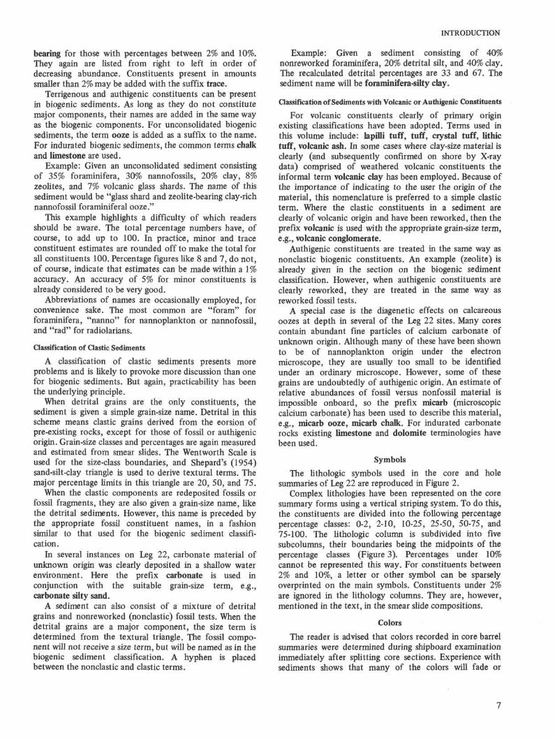
Symbols
The lithologic symbols used in the core and holesummaries of Leg 22 are reproduced in Figure 2.
Complex lithologies have been represented on the coresummary forms using a vertical striping system. To do this,the constituents are divided into the following percentagepercentage classes: 0-2, 2-10, 10-25, 25-50, 50-75, and75-100. The lithologic column is subdivided into fivesubcolumns, their boundaries being the midpoints of thepercentage classes (Figure 3). Percentages under 10%cannot be represented this way. For constituents between2% and 10%, a letter or other symbol can be sparselyoverprinted on the main symbols. Constituents under 2%are ignored in the lithology columns. They are, however,mentioned in the text, in the smear slide compositions.
Colors
The reader is advised that colors recorded in core barrelsummaries were determined during shipboard examinationimmediately after splitting core sections. Experience withsediments shows that many of the colors will fade or

INTRODUCTION
Nannofossil Ooze
Limestone
J L I 1
Radiolarian Ooze
Clay
Sand S i l t Clay
Zeolite
z z z z z z z zz z z z z z z z
z z z z z z z zz z z z z z z z
z z z z z z z zz z z z z z z z
Foraminiferal Ooze
Dolomite
Diatom-Rad orSiliceous Ooze
Clayey S i l t andSi l ty Clay
MicarbCH tZ» o c
'ODOOOOC3DDOOOO
IXZ>
~ir~ir
3 O4=> C
Glauconite
G G G G G G G G3 G G G G G G GG G G G G G G G
1 G G G G G G GG G G G G G G G
G G G G G G G G
Nannofossili i i
i i i
1 1 1
1 j1 ' '
1 i I
Chalk
i
i
i
Chert
• • A A
• • A •
A A A A
Sand
S i l t
Volcanic Ash
Basic Igneous
Λ Λ
A> < >7 T v v
< 7 > A < *
Figure 2. Lithologic symbols and letters used on core and site summary forms.
Nanno-Foram orCalcareous Chalk
11
11
11
1i
•
ii
i
i
i
1i
i
1
1
1
•
•
1
1
1
1
1
1
1
1
i
1
1
1
1
i
i
•
Diatom Ooze
Sandy Clay andClayey Sand
Sandy Silt andSilty Sand
Volcanic Lapilli
Manganese =
Iron Oxide =\Fe
disappear with time after opening and storage. Colorsparticularly susceptible to rapid fading are purple, light andmedium tints of blue, light bluish gray, dark greenish black,light tints of green, and pale tints of orange. These colorschange to white or yellowish white or pale tan.
Survey Data
Specific site surveys for holes drilled on Leg 22 of theDeep Sea Drilling Project were carried out in the vicinity ofthree sites only (211, 214, 216). The other sites werechosen on the basis of existing seismic profiles.

INTRODUCTION
> 10-25%(pref ix r ich)
> 25-50%
> 50-75%
> 75-90%
75-90%
50-75%
25-502
10-25%
Figure 3. Vertical bar width representationof class limits.
Data for each site is as follows:Site 211-CONRAD 14 site surveySite 212-CONRAD 9 seismic lineSite 213-ANTIPODE 12 seismic lineSite 214-CONRAD 14 site surveySite 215-CIRCE 5 seismic lineSite 216-CONRAD 14 site surveySite 217-ANTIPODE 11 seismic lineSite 218-ANTIPODE 11 seismic line
We would like to acknowledge the assistance ofLamont-Doherty Geological Observatory of ColumbiaUniversity in providing data from the CONRAD cruisesand, in particular, G. Carpenter for making the survey ofSite 211 and S. Eittreim for the surveys of Sites 214 and216. Scripps Institution of Oceanography, University ofCalifornia at San Diego, provided data from the CIRCE andANTIPODE cruises. We would particularly like to thank J.Curray and D. Moore for their work in the vicinity of Sites217 and 218 on cruise ANTIPODE 11 which they madeavailable to us.
Criteria for Correlating Reflection Profile and StratigraphicColumn
1) Ignore laboratory determinations of sediment veloci-ties. The wide variations in the Leg 22 values must indicateeither (a) instrumental error, or (b) rearrangement of thepacking (and hence porosity-density) of the sediment. Inthis view, only consolidated materials, including chert andbasalt, have their physical properties unaffected by thedrilling process.
2) Determine the interval velocity of the entiresediment column. This was precisely calculable for all butthe last two holes on Leg 22, because the depth to volcanicrocks was unequivocally determined in both profile andhole.
3) This value imposes the chief constraint on intervalvelocities between reflectors. For example, the overallvelocity of 1.7 km/s in Hole 211 rules out the possibility ofany significant intervals having velocities greater than, say,2.0 km/s.
4) Identifications of reflections with depth in the hole ismade at "obvious" lithological boundaries and immediatelytested by calculating the resulting interval velocity. For
example, in Hole 214, the tentative identification ofreflector 2 at a marked geological boundary at 333 metersleads to a calculated interval velocity of 1.1 km/s, which isrejected.
5) This process is continued until an optimum matrix ofdepths (if possible, related to recognizable lithologicalboundaries) and reflection time, with acceptable intervalvelocities, is derived.
6) Whichever method is used, one can be certain that,except for the sea floor and volcanic basement, theidentification will be inherently uncertain.
Inorganic Geochemistry Program
A flow sheet showing the handling and experimentalprocedures for the Leg 22 geochemistry program is given asFigure 4.
For the first time since Leg 15, samples were collectedby removing a 10-cm "mini-core" at the time thesediment-filled liner was subdivided into 150-cm sections.These mini-cores were taken to the chemistry laboratoryand resistivity and punch-in pH measurements were madeimmediately on the undisturbed sediment. The resistivitymeasurements were made with a Schlumberger-type EMT-Dmud tester. The punch-in pH measurements were madewith a Model 801 Orion digital pH/mv meter using aBeckman Model 39301 pH electrode and an Orion Model90-02 double junction reference electrode. Temperatureswere measured with a Weston s.s. dial thermometer.
Mini-core sediment samples were extruded from theplastic liner, impaled on a s.s. spatula, and scraped toremove 1-5 mm of material which had been in contact withthe liner. Mini-cores were split lengthwise primarily toexamine them for evidence of drilling fluid intrusion.
The pH measurements on the freshly squeezed,unfiltered pore water were made with an Orionflow-through electrode of the same type as used for the Leg15 geochemical program. Resistivity measurements weremade on 2-ml portions of pore water using a "suck-up" cellprovided with the Schlumberger instrument.
ACKNOWLEDGMENTS
The authors wish to thank Captain Lloyd Dill, DrillingSuperintendent, C. Guess, and their crews; and OperationsManager, L. Hayes, whose excellent performance made thespectacular results of Leg 22 possible. Of special note wasthe large recovery of basaltic material from many sitesincluding the deepest (Site 212) so far drilled by the projectand also the successful penetration at two sites (211, 218)of thick sequences of sandy turbidite material which isnotoriously difficult in such a drilling opearation as thatemployed by the Challenger. AH this was accomplishedwithout the loss of a single hole or item of drillingequipment. Undoubtedly this was a wonderful performanceby the drilling crews.
Appreciation is also extended to the very competentstaff of marine technicians under the direction of T. B.Gustafson. Of special mention was the performance of theelectronics technicians P. Porter and A. Porter for theirefforts towards the success of the heat flow program on thiscruise.
Deep Sea Drilling shore laboratories at La Jolla providedgrain size and carbon-carbonate analyses under the

INTRODUCTION
CORE SECTION
Bottom
Resistivity measurements
Top
10 cm Mini-cores
Spl i t for inspection
Squeezed for pore water
Unfiltered Pore Water
Flow-through pH meas.
Filtered Pore Water
Punch-in pH measurements
Major Elements(WHOI)
+ HCl/Alkalinity, Ca(WHOI)
Major Elements(TAM)
UnsqueezedSediment
\
Isotopes(UCLA)
Isotopes(USGS-Denver)
Resist ivi ty Measurement
SqueezedSediment
Ends capped andsealed with plastictape. Return to WHOIfor shore lab studies
X-ray Mineralogy(UCR)
Heat sealedin plasticpouches forshore labstudies.
All Pore Water and Sediment Samples stored at 4°C.
Figure 4. Inorganic geochemistry program for Leg 22.
10

INTRODUCTION
direction of G. Bode. X-ray diffraction analyses were madeat the University of California at Riverside under thesupervision of H. E. Cook.
REFERENCES
Ahmad, F., 1961. Paleogeography of the Gondwana periodin Gondwanaland, with special reference to India andAustralia and its bearing on the theory of continentaldrift: Mem. Geol. Surv. India, v. 90, p. 142.
Belousov, I. M., Zatonskii, L. K., Kanaev, V. F., andMarova, H. A., 1962. Bathymetric map of the IndianOcean: U.S.S.R. (Institute of Oceanology).
Berggren, W. H., 1972. A Cenozoic time scale-someimplications for regional geology and paleobiogeo-graphy: Lethaia, v. 5, p. 195-215.
Crawford, A. R., 1969. India, Ceylon and Pakistan: new agedata and comparisons with Australia: Nature, v. 223, p.380-384.
Curray, J. R. and Moore, D. G., 1971. Growth of theBengal deep-sea fan and denudation of the Himalayas:Geol. Soc. Am. Bull. v. 82, p. 563-572.
Dietz, R. D. and Holden, J. C , 1971. Pre-Mesozoic oceaniccrust in the eastern Indian Ocean (Wharton Basin):Nature, v. 229, p. 309-312.
duToit, A. L., 1937. Our wandering continents; Edinburgh(Oliver and Boyd) (reprinted 1957).
Falvey, D. A., 1972. Sea-floor spreading in the WhartonBasin (Northeast Indian Ocean) and the break-up ofeastern Gondwanaland: Aust. Petrol. Expl. Assoc. J., v.12, p. 86-88.
Fisher, R. L., Sclater, J. G., and McKenzie, D. P., 1971. Theevolution of the Central Indian Ridge, Western IndianOcean: Geol. Soc. Am. Bull., v. 82, p. 553.
Funnell, B. M., 1971. The occurrence of pre-Quaternarymicrofossils in the oceans. In The micropaleontology ofoceans: Funnel, B. M., and Riedel, W. R. (Eds). London(Cambridge University Press).
Hayes, D. E., Pimm, A. C , et al., 1972. Initial Reports ofthe Deep Sea Drilling Project, Volume XIV: Washington(U. S. Government Printing Office).
King's 1950. Reconstruction of Gondwanaland. InDickinson, W. R., (1971). Plate tectonic models fororogeny at continental margins: Nature, v. 232, p. 41.
Laughton, A. S., McKenzie, D. P., and Sclater, J. G. Thestructure and solution of the Indian Ocean. Int. Geol.Congr., 24th, Section 8.
McKenzie, D. P. and Sclater, J. G., 1971. The evolution ofthe Indian Ocean since the Late Cretaceous: Geophys. J.Roy. Astr. Soc, v. 25, p. 437-528.
Moore, D. G., Curray, J. R., and Raitt, R. W., 1971. Astructure and history of the Bengal deep-sea fan andgeosyncline, Indian Ocean: Program of abstracts,Sediment. Congr. VIII, Heidelberg, Germany.
Riedel, W. R., 1971. The occurrence of pre-QuaternaryRadiolaria in deep sea sediments. In The micropalaeon-tology of oceans: Funnell, B. M. and Riedel, W. R.,(Eds.), London (Cambridge University Press), p.567-599.
Sclater, J. G. and Fisher, R. L., in press. The evolution ofthe east central Indian Ocean with emphasis on thetectonic setting of the Ninetyeast Ridge. Geol. Soc. Am.Bull.
Shepard, F. P., 1954. Nomenclature based on sand-silt-clayratios: J. Sediment. Petrol., v. 24, p. 151-158.
Smith, A. G. and Hallam, A., 1970. The fit of the southerncontinents: Nature, v. 225, p. 139-144.
Veevers, J. J., Jones, J. G., and Talent, J. A., 1971.Indo-Australian stratigraphy and the configuration anddispersal of Gondwanaland: Nature, v. 229, p. 383-388.
11