1 I NTRODUCTION - City of Newport Beach | Home DEVELOPMENT PLAN 1-4 mdp chapter 1, introduction...
20
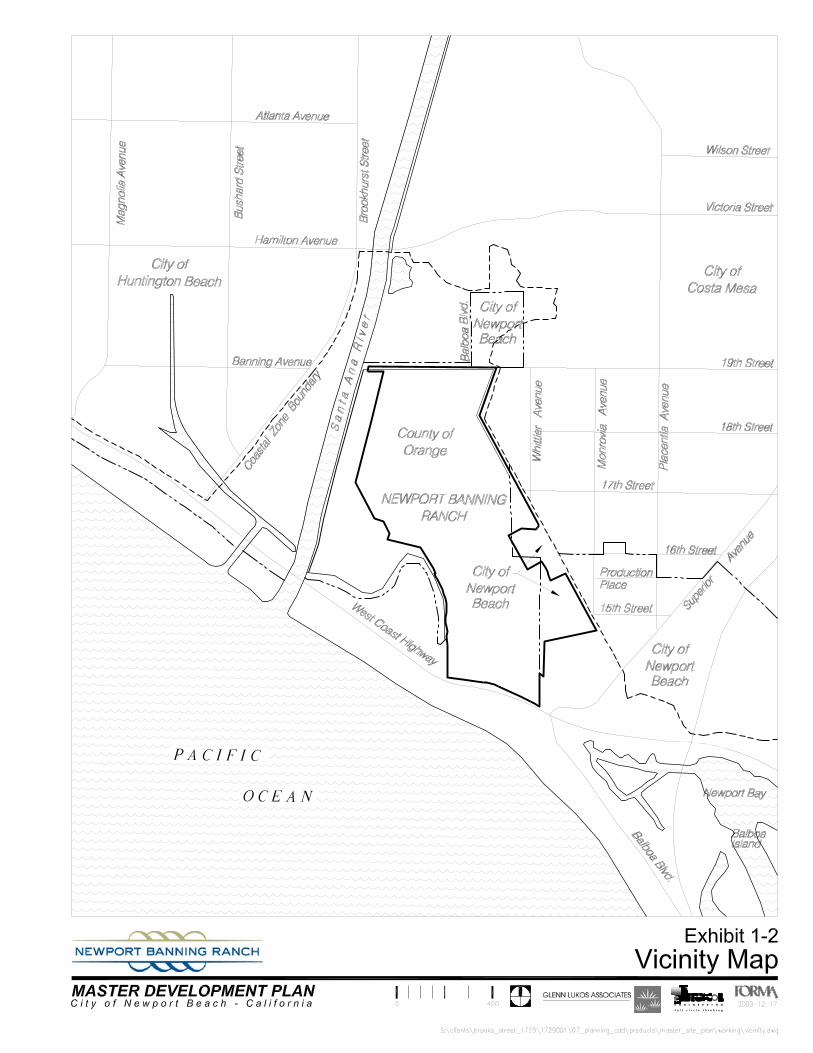
1 INTRODUCTION Newport Banning Ranch 1-1 mdp chapter 1, introduction 08.19.11 final.docx • August 19, 2011 1.1 Project Location and Setting The Newport Banning Ranch site (Project Site) is an approximately 401 acre site located north of West (Pacific) Coast Highway, south of 19th Street, east of the Santa Ana River, and west of developed urban areas in the City of Newport Beach and City of Costa Mesa. Exhibit 1-1, “Regional Setting Map,” and Exhibit 1-2, “Vicinity Map,” illustrate the Project Site’s location. Approximately 41 acres of the Project Site are located within the City of Newport Beach (City). Approximately 360 acres of the Project Site are located in unincorporated Orange County, within the City’s Sphere of Influence (SOI). The entire Project Site is located within the California Coastal Zone as defined by the California Coastal Act (Coastal Act). The Project Site is surrounded by existing residential, industrial, institutional and open space land uses, as illustrated in Exhibit 1-3, “Surrounding Land Uses and Neighborhoods Map,” and as described below. The Talbert Nature Preserve, an existing nature preserve and open space use, is located adjacent to the northerly boundary of the Project Site. Existing restored wetlands owned by the U.S. Army Corps of Engineers are located adjacent to the northwestern boundary of the Project. The Semeniuk Slough and the adjacent Newport Shores residential area are adjacent to the southwestern boundary of the Project Site. The residential communities of Newport Crest and Newport Knolls, and the City of Newport Beach Sunset Ridge Park site, are located adjacent to the southeastern boundary of the Project Site. The residential communities of Newport Terrace and California Seabreeze are located adjacent to the northeastern boundary of the Project Site. Light industrial uses and a vacant site owned by the Newport-Mesa Unified School District are located adjacent to the eastern boundary of the Project Site. West Coast Highway abuts the southern boundary of the Project Site. The Lido Sands residential community and other West Newport Beach residential neighborhoods are located south of and adjacent to West Coast Highway.
Transcript of 1 I NTRODUCTION - City of Newport Beach | Home DEVELOPMENT PLAN 1-4 mdp chapter 1, introduction...
1 INTRODUCTION
Newport Banning Ranch 1-1mdp chapter 1, introduction 08.19.11 final.docx • August 19, 2011
1.1 Project Location and Setting The Newport Banning Ranch site (Project Site) is an approximately 401 acre site located north of West (Pacific) Coast Highway, south of 19th Street, east of the Santa Ana River, and west of developed urban areas in the City of Newport Beach and City of Costa Mesa. Exhibit 1-1, “Regional Setting Map,” and Exhibit 1-2, “Vicinity Map,” illustrate the Project Site’s location. Approximately 41 acres of the Project Site are located within the City of Newport Beach (City). Approximately 360 acres of the Project Site are located in unincorporated Orange County, within the City’s Sphere of Influence (SOI). The entire Project Site is located within the California Coastal Zone as defined by the California Coastal Act (Coastal Act). The Project Site is surrounded by existing residential, industrial, institutional and open space land uses, as illustrated in Exhibit 1-3, “Surrounding Land Uses and Neighborhoods Map,” and as described below.
The Talbert Nature Preserve, an existing nature preserve and open space use, is located adjacent to the northerly boundary of the Project Site.
Existing restored wetlands owned by the U.S. Army Corps of Engineers are located adjacent to the northwestern boundary of the Project.
The Semeniuk Slough and the adjacent Newport Shores residential area are adjacent to the southwestern boundary of the Project Site.
The residential communities of Newport Crest and Newport Knolls, and the City of Newport Beach Sunset Ridge Park site, are located adjacent to the southeastern boundary of the Project Site.
The residential communities of Newport Terrace and California Seabreeze are located adjacent to the northeastern boundary of the Project Site. Light industrial uses and a vacant site owned by the Newport-Mesa Unified School District are located adjacent to the eastern boundary of the Project Site.
West Coast Highway abuts the southern boundary of the Project Site.
The Lido Sands residential community and other West Newport Beach residential neighborhoods are located south of and adjacent to West Coast Highway.

MASTER DEVELOPMENT PLAN
1-2 mdp chapter 1, introduction 08.19.11 final.docx • August 19, 2011
1.2 Purpose and Intent The Project Site is within the boundaries of the Newport Banning Ranch Planned Community Development Plan (NBR-PC) which provides the land use and development regulations for the Project Site. The NBR-PC requires that a Master Development Plan be approved by the City for the entire 401 acre Project Site prior to any development. The purpose and intended use of the Newport Banning Ranch Master Development Plan (NBR-MDP) are to:
Establish a master plan of land use for the Project Site and development plans for each land use component to include a general layout of streets and infrastructure, a grading concept, and development plans for residential, visitor serving resort, park, and commercial land use.
Establish the design criteria for development of each land use component within the
Project Site with a sufficient level of detail to guide the City’s review of subsequent development approvals as required by the NBR-PC including but not limited to grading permits, Site Development Review, and construction-level permits.
Comply with the provisions of the NBR-PC which require City approval of a Master
Development Plan prior to issuance of any grading or construction permit for development of any portion of the Project Site.
Comply with the provisions of the NBR-PC which requires approval of a Coastal
Development Permit by the California Coastal Commission by serving as an application for a Coastal Development Permit, consistent with the requirements of the NBR-PC for approval by the Coastal Commission of a Master Coastal Development Permit.
1.3 Land Use and Site Planning Areas Land use designations within the NBR-MDP consist of the following three major land use categories: 1. Open Space Preserve, which includes permanent open space and public trails;
2. Parklands, which include a public community park and public bluff parks and interpretive parks; and

INTRODUCTION
Newport Banning Ranch 1-3
3. Villages and Colonies which include residential, commercial, and visitor-serving uses. The Villages and Colonies include:
a. North Family Village and South Family Village residential development areas;
b. Urban Colony mixed use residential and commercial development area; and
c. Resort Colony visitor serving resort and residential development area.
Land use areas of the NBR-MDP are further described as geographic Site Planning Areas (SPAs). The land use plan and Site Planning Areas of the NBR-MDP are illustrated in Exhibit 1-4, “Site Planning Areas Map” and described in Exhibit 1-5, “Site Planning Areas Table.” The NBR-MDP addresses the requirements of NBR-PC Section 4.4.2, “Contents of Master Development Plan” and contains project development plans describing the location and layout for public streets, private alleys and access, single-family residential lots, lots for single family attached, multi-family residential, and commercial development, pedestrian pathways, parks, and other development components of the Project Site. The NBR-MDP includes plans for roadway and infrastructure improvements necessary to serve the Project including domestic water facilities, sewer facilities, drainage and water quality management facilities, and other utilities. The NBR-MDP also includes a plan for grading of development areas and public open space trails as well as details for habitat restoration within the permanent open space areas of the Project Site.
1.4 Applicability All development activity within the Project Site is subject the requirements of the design and development criteria established in the NBR-MDP excepting City implemented projects, and continuing oil production activities to be located within the Consolidated Oil Sites which are regulated by the State Division of Gas and Geothermal Resources (DOGGR). When used in the NBR-MDP, the words "shall," "must," "will," "is to," and "are to" are always mandatory, and "may" is permissive. The present tense includes the past and future tenses; and the future tense includes the present. The singular number includes the plural number, and the plural the singular, unless the common meaning of the word indicates otherwise. The words "includes" and "including" shall mean "including, but not limited to."

MASTER DEVELOPMENT PLAN
1-4 mdp chapter 1, introduction 08.19.11 final.docx • August 19, 2011
1.5 Master Development Plan Organization and Contents The NBR-MDP is formatted to be consistent with the requirements of the NBR-PC and is, organized as follows: Chapter 1, Introduction – describes the project location and setting, the purpose and intent of
the NBR-MDP, and defines the Site Planning Areas of the NBR-MDP.
Chapter 2, Existing Conditions – describes the physical characteristics of the Project Site, including access and visibility, topography and landform, visual character, geotechnical conditions, oil operations, drainage and jurisdictional wetlands, and vegetation.
Chapter 3, Land Use and Development Plans – describes the land use and development plans for each of the following major land use components of the NBR-MDP.
o Open Space Preserve – describes the Open Space Preserve components of the NBR-MDP, which includes Upland and Lowland Habitat Conservation, Restoration, and Mitigation Areas, Public Interpretive Trails, Drainage Management Areas, Consolidated Oil Sites (Interim Use), and Oil Site Planting Buffers.
o Parklands – describes the public park components of the NBR-MDP, which include a Public Community Park, a Public Bluff Park, and Public Interpretive Parks.
o Villages and Colonies – describe the residential commercial, and resort components of the NBR-MDP, which include the North and South Family Villages, the Urban Colony, and the Resort Colony.
Chapter 4, Master Trails and Coastal Access Plan – describes the Project’s public trails and coastal access plan, including the connections to off-site trails, trailheads, public interpretive areas, and pedestrian bridge over West Coast Highway.
Chapter 5, Master Landscape Plan – describes the Project’s landscape zones, streetscape plans, street signage and light fixtures, walls, fencing, and monumentation plans, and the design requirements to ensure land use compatibility between the Project and adjacent land use, and the design features of the MDP to buffer new land uses from continuing oil production operations.
Chapter 6, Architectural Design Guidelines – describes the design and character for residential housing types, provides concept design plans and architectural character for the visitor serving resort facility and portions of the mixed use commercial and residential uses. This chapter also includes a master architectural color palette for the Project.
INTRODUCTION
Newport Banning Ranch 1-5
Chapter 7, Landform Restoration and Grading Plan – describes existing topographical and geotechnical conditions within the Project Site and the plans for bluff/slope restoration, the grading plan infrastructure and development, areas, the disposition of remediated soil, and minor grading for public open space trails.
Chapter 8, Master Roadway and Infrastructure Plans – describes the master plan of roadway improvements for the Project and the plans for domestic water distribution, wastewater collection and disposal, drainage facilities, and dry utilities and services.
Chapter 9, Water Management Plans – describes the master drainage plan and a comprehensive Water Quality Management Plan for the Project.
Chapter 10, Implementation – describes the requirements for implementation of land use development through the requirements for subsequent City approvals and Coastal Commission approvals and describes the procedures for administering the NBR-MDP.
Chapter 11, Definitions – defines the terms and acronyms that are used in the NBR-MDP.
Appendices – The Appendices section contains five technical implementation plans and programs:
A. NBR Habitat Restoration Plan (HRP); B. NBR Fire and Life Safety Program (FLSP); C. NBR Plant Palette; D. NBR Green and Sustainable Program (GSP); and E. Tentative Tract Map No. 17308.


Newport Shores
Lido Sands
West Newport Beach Newport Island Incorporated
Newport Beach Townhouse
Balboa Coves Newport Crest Seawind Newport Newport Knolls Park Lido Versailles Villa Balboa Newport Terrace
11
22
33
44
55
66
77
88
99
1010
1111
1212
1313
1414
1313
11
22
33
55
44
66
1212
1111
1010
77
99
88
Newport BeachNewport Beach
NewportBeach
Costa MesaCosta Mesa
S A
N T
A
A N
A
R I
V E
R
S A
N T
A
A N
A
R I
V E
R
ACOE ACOE Wetlands Wetlands
Restoration Restoration AreaArea
HuntingtonHuntingtonBeachBeach
Newport BeachNewport BeachWest Coast Highway
West Coast Highway
West Coast Highway
West Coast Highway
Super
ior A
venu
e
Super
ior A
venu
e
Newport Banning Newport Banning Ranch Project SiteRanch Project Site
1414
NNN
LEGEND
NMUSDNMUSD
Sunset RidgeSunset RidgeParkPark
Talbert NatureTalbert NaturePreservePreserve
Marina ViewMarina ViewParkPark
Canyon ParkCanyon Park
Newport Beach Residential Neighborhoods
California SeabreezeCosta Mesa Residential Neighborhoods
S:\clients\brooks_street_1729\1729001\07_planning_cad\products\master_site_plan\working\InDesign\introduction_8x11.indd
2010 • 03 • 02
M A S T E R DEVELOPMENT P L A NM A S T E R DEVELOPMENT P L A NC i t y o f N e w p o r t C i t y o f N e w p o r t B e a c h - C a l i f o r n i aB e a c h - C a l i f o r n i a
Exhibit 1-3Surrounding Land Uses
and Neighborhoods Map


Right-of-Way Reservation
S A N
T A
A N A
R I V
E R
ACOEWetlands
RestorationArea
18th Street
Whitti
er Av
e.
Monro
via Av
e.
17th Street
Newhall Street
16th Street
15th Street
19th StreetBalbo
aStr
eet
W e s t C o a s tH i g h w a y
SemeniukSlough
Sunset RidgePark
Ro a d
B l u f f
ProposedPedestrian Bridge
Proposed PermanentConnection to Sunset Ridge Park
NMUSD
B l uf f
R o a d
Nor t h B
l u f f R o a d
N o r t h
CityUtilities
Yard
2b
1b1b
1a
13b
13a5a
6a
11b
1a
7c
3c
5b
8b
10a
10c
10d
10b
12a
1d
1c
10a
12b1e
4a2a
5c6b2a
2a
3b
1e
1f
2a
3b
2b
1h
3d
11a
1g9c
8b
3b
1c
3d
8a
7b
1a
9b
4b
10b
10b10c
10b
10d
8b
8a
8b
9a
7a
1g
3d
10a
Urban ColonyU
North Family Village
South Family Village
Resort Colony
Scenic Drive
'D' Street
Resort Colony Road
06 • 13 • 2011
S:\clients\brooks_street_1729\1729001\08_gis\products\master_site_plan\mxds\ch1\spa_11x17_fs110613.mxd
Exhibit 1-4Site Planning Areas Map
0 600 1,200
LEGENDProject Site Boundary
OPEN SPACE PRESERVE
PARKLANDS
Public Interpretive Trail
Drainage Management Areas
Upland Habitat Conservation, Restoration, and Mitigation
Consolidated Oil Site / Non-exclusive Access Easement
Oil Site Buffer
Public Community Park
Public Bluff Park
Public Interpretive Parks
VILLAGES AND COLONIES
PUBLIC ROADWAYS
North and South Family Villages
Urban Colony
Resort Colony
MASTER DEVELOPMENT PLANC i t y o f N e w p o r t B e a c h - C a l i f o r n i a
Collector Roads
Arterial Roads
Pedestrian Paseo
Right-of-Way Reservation for City 19th StreetExtension from NBR's Easterly Boundary to Santa Ana River
Lowland Habitat Conservation, Restoration, and Mitigation


INTRODUCTION
Newport Banning Ranch 1-15
No. Description
UOS/PTF 1a West Coast Highway Bluff Area 15.3 14.3UOS/PTF 1b Southern Arroyo CSS / Grassland Area 28.3 28.0UOS/PTF 1c Scenic Bluff CSS / Grassland Area 13.0 13.0
UOS/PTF 1d Vernal Pool Preservation Area 3.2 3.2
UOS/PTF 1e South Upland CSS / Grassland Area 19.4 18.1
UOS/PTF 1f Northern Arroyo Grassland Area 5.8 5.5
UOS/PTF 1g North Upland CSS / Grassland Area(3) 16.3 13.5
UOS/PTF 1h Minor Arroyo Grassland Area 1.2 1.1
102.5 96.7
LOS/PTF 2a Southerly Habitat Mitigation/Protection Area 75.8 75.8
LOS/PTF 2b Northerly Habitat Mitigation/Protection Area(3) 42.6 40.3
118.4 116.1
LOS/PTF 3a Bluff Toe Trail(2) -- --
LOS/PTF 3b Lowland Interpretive Trail(3) 7.3 7.1
UOS/PTF 3c Southern Arroyo Trail 0.7 0.7
UOS/PTF 3d Upland Interpretive Trail 1.5 1.5
9.5 9.3
LOS/PTF 4a Water Quality Basin 2.2 2.2
UOS/PTF 4b Diffuser Basin / Habitat Area 0.4 0.4
2.6 2.6
OF 5a Southerly Oil Operations Site 4.8 4.8
OF 5b Oil Access Road (Non-exclusive Access Easement) 3.1 3.1
OF 5c Northerly Oil Operations Site 8.6 8.6
16.5 16.5
UOS/PTF 6a Southerly Oil Site Planting Buffer 0.1 0.1
LOS/PTF 6b Northerly Oil Site Planting Buffer 2.7 2.7
2.8 2.8
252.3 244.0SUBTOTAL OPEN SPACE PRESERVE
6. OIL SITE BUFFERS
Subtotal
Subtotal
Subtotal
LAN
D U
SE D
ISTRICT
SITE PLANNING AREA
5. CONSOLIDATED OIL SITES (Interim Use)
2. LOWLAND HABITAT CONSERVATION, RESTORATION, AND MITIGATION AREAS
3. PUBLIC INTERPRETIVE TRAILS
Subtotal
Subtotal
4. DRAINAGE MANAGEMENT AREAS
NET
AC
RES (1
)
GRO
SSA
CR
ES (1)
OPEN SPACE PRESERVE1. UPLAND HABITAT CONSERVATION, RESTORATION, AND MITIGATION AREAS
Subtotal
EXHIBIT 1-5
SITE PLANNING AREAS TABLE Newport Banning Ranch


INTRODUCTION
Newport Banning Ranch 1-17
No. DescriptionPARKLANDS
CP 7a South Community Park 5.0 3.7CP 7b Central Community Park 5.9 4.5CP 7c North Community Park 15.9 13.5
26.8 21.7
BP 8a South Bluff Park 7.3 6.9BP 8b North Bluff Park 13.6 10.6
20.9 17.5
IP 9a Nature Center 2.2 2.2IP 9b Vernal Pool Interpretive Area 1.4 0.6IP 9c Talbert Trailhead Area 0.1 0.1
3.7 2.9
51.4 42.1VILLAGES AND COLONIES
RL 10a Single-Family Detached Residential 17.1 13.4RL/M 10b Single-Family Detached Residential 11.8 8.1RM 10c Single-Family Detached Residential 8.3 6.0RM 10d Multi-Family Attached Residential 8.8 5.9
46.0 33.4
RL 11a Single-Family Detached Residential 9.0 7.6RM 11b Single-Family Detached Residential 10.2 6.8
19.2 14.4
MU/R 12a Multi-Family Attached Residential/Mixed-Use Commercial 9.8 8.5MU/R 12b Multi-Family Attached Residential/Mixed-Use Commercial 11.1 9.8
20.9 18.3
VSR/R 13a Resort Hotel (75 Guest Rooms/ Spa/ Fitness Center/ Restaurants/ Shops) 5.7 5.2VSR/R 13b Multi-Family Attached Residential 5.6 5.4
11.3 10.6
97.4 76.7
401.1 362.8
Subtotal
Subtotal
11. SOUTH FAMILY VILLAGE
SUBTOTAL VILLAGES AND COLONIES
TOTAL PROJECT
7. PUBLIC COMMUNITY PARKS
13. RESORT COLONY
Subtotal
8. PUBLIC BLUFF PARKS
Subtotal
Subtotal
9. PUBLIC INTERPRETIVE PARKS
Subtotal
SUBTOTAL PARKLANDS
Subtotal
10. NORTH FAMILY VILLAGE
12. URBAN COLONY
LAN
D U
SE D
ISTRICT
SITE PLANNING AREA
NET
AC
RES (1)
GRO
SSA
CR
ES (1)
EXHIBIT 1-5 (continued)
SITE PLANNING AREAS TABLE Newport Banning Ranch


INTRODUCTION
Newport Banning Ranch 1-19
EXHIBIT 1-5 (continued)
SITE PLANNING AREAS TABLE FOOTNOTES Newport Banning Ranch
(1) Gross Acres of Site Planning Areas are measured to the centerlines of all public roads where such roads are shown on the Master Development Plan. Net Acres of Site Planning Areas are measured to edges of the right-of-ways of all public roads where such roads are shown on the Master Development Plan (i.e., Net Acres exclude public road rights-of-way).
(2) The Bluff Toe Trail is located within the non-exclusive access easement identified as SPA 5b, Oil Access Road.
(3) The Right-of-Way Reservation for the 19th Street Extension, from the Project Site's easterly boundary to the Santa Ana River, encompasses approximately 3.1 total acres, including approximately 0.6 acres of SPA 1g, 2.3 acres of SPA 2b, and 0.2 acres of SPA 3b.