1 Copyright © 2013, Oracle and/or its affiliates. All...
44
Copyright © 2013, Oracle and/or its affiliates. All rights reserved. 1
-
Upload
duongduong -
Category
Documents
-
view
217 -
download
0
Transcript of 1 Copyright © 2013, Oracle and/or its affiliates. All...

Copyright © 2013, Oracle and/or its affiliates. All rights reserved. 1

What’s New in Location Analytics Jayant Sharma Director, Product Mgmt
Copyright © 2013, Oracle and/or its affiliates. All rights reserved. 3
The following is intended to outline our general product direction. It is intended for information purposes only, and may not be incorporated into any contract. It is not a commitment to deliver any material, code, or functionality, and should not be relied upon in making purchasing decisions. The development, release, and timing of any features or functionality described for Oracle’s products remains at the sole discretion of Oracle Corporation.
Copyright © 2013, Oracle and/or its affiliates. All rights reserved. 4
Copyright © 2013, Oracle and/or its affiliates. All rights reserved. 5
Copyright © 2013, Oracle and/or its affiliates. All rights reserved. 6
Program Agenda
MapViewer: new features
Spatial & Graph 12c: new features
Demos
Discussion
Copyright © 2013, Oracle and/or its affiliates. All rights reserved. 7
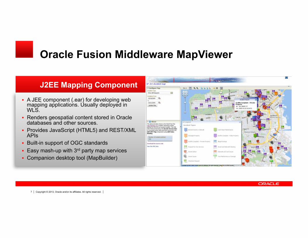
J2EE Mapping Component
Oracle Fusion Middleware MapViewer
A JEE component (.ear) for developing web mapping applications. Usually deployed in WLS.
Renders geospatial content stored in Oracle databases and other sources.
Provides JavaScript (HTML5) and REST/XML APIs
Built-in support of OGC standards Easy mash-up with 3rd party map services Companion desktop tool (MapBuilder)
Copyright © 2013, Oracle and/or its affiliates. All rights reserved. 8
Primary Focus Areas
Rich client interactivity Map data editing 3rd party data sources Separate MVDEMO samples app
For enhancements
Copyright © 2013, Oracle and/or its affiliates. All rights reserved. 9
Rich client interactivity
Complete re-write of the Oracle Maps JavaScript API Based on HTML5 (canvas & svg) standards Much richer client-side rendering & interaction Mobile support Supports lightweight data editing and region management Provides a robust, cleaner and richer mapping client for app
developers.
HTML5 based Javascript API
Copyright © 2013, Oracle and/or its affiliates. All rights reserved. 10
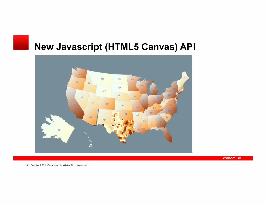
New Javascript (HTML5 Canvas) API
Copyright © 2013, Oracle and/or its affiliates. All rights reserved. 11
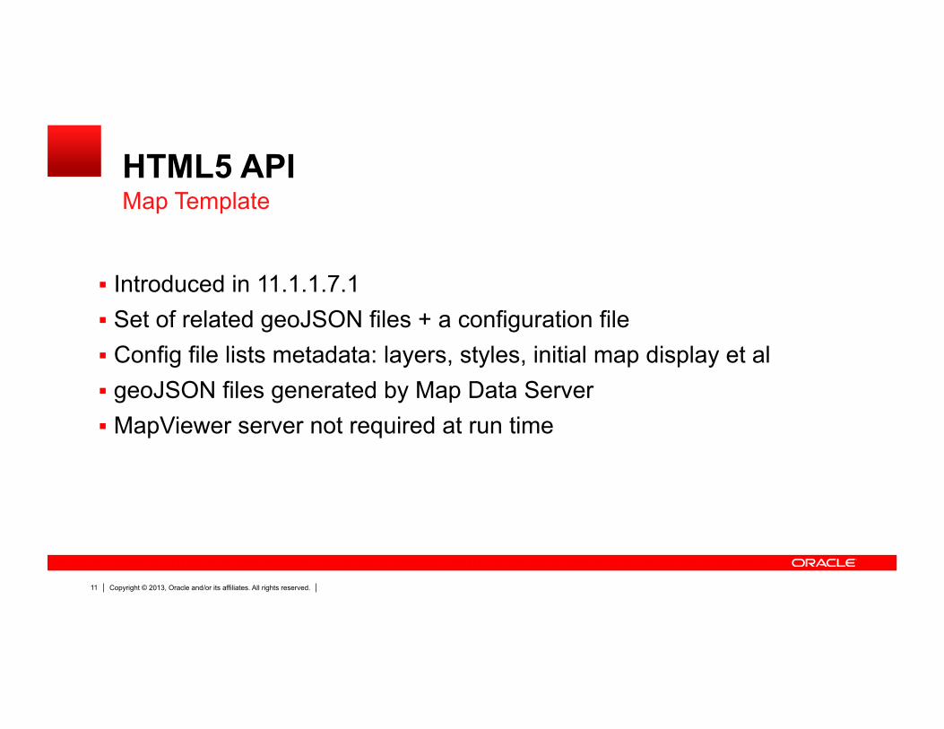
HTML5 API
Introduced in 11.1.1.7.1 Set of related geoJSON files + a configuration file Config file lists metadata: layers, styles, initial map display et al geoJSON files generated by Map Data Server MapViewer server not required at run time
Map Template
Copyright © 2013, Oracle and/or its affiliates. All rights reserved. 12
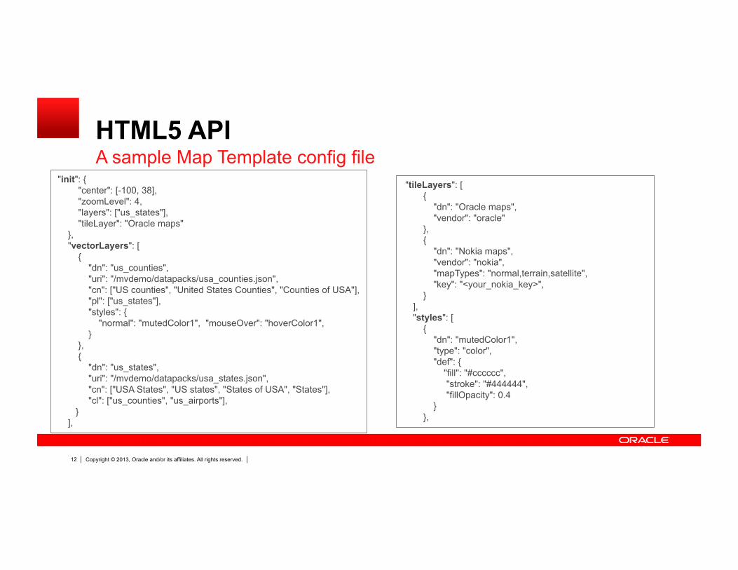
HTML5 API A sample Map Template config file
"init": { "center": [-100, 38], "zoomLevel": 4, "layers": ["us_states"], "tileLayer": "Oracle maps" }, "vectorLayers": [ { "dn": "us_counties", "uri": "/mvdemo/datapacks/usa_counties.json", "cn": ["US counties", "United States Counties", "Counties of USA"], "pl": ["us_states"], "styles": { "normal": "mutedColor1", "mouseOver": "hoverColor1", } }, { "dn": "us_states", "uri": "/mvdemo/datapacks/usa_states.json", "cn": ["USA States", "US states", "States of USA", "States"], "cl": ["us_counties", "us_airports"], } ],
"tileLayers": [ { "dn": "Oracle maps", "vendor": "oracle" }, { "dn": "Nokia maps", "vendor": "nokia", "mapTypes": "normal,terrain,satellite", "key": "<your_nokia_key>", } ], "styles": [ { "dn": "mutedColor1", "type": "color", "def": { "fill": "#cccccc", "stroke": "#444444", "fillOpacity": 0.4 } },
Copyright © 2013, Oracle and/or its affiliates. All rights reserved. 13
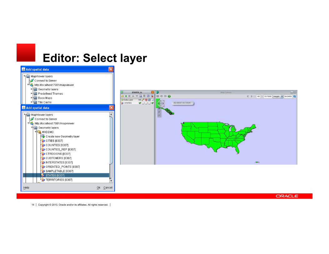
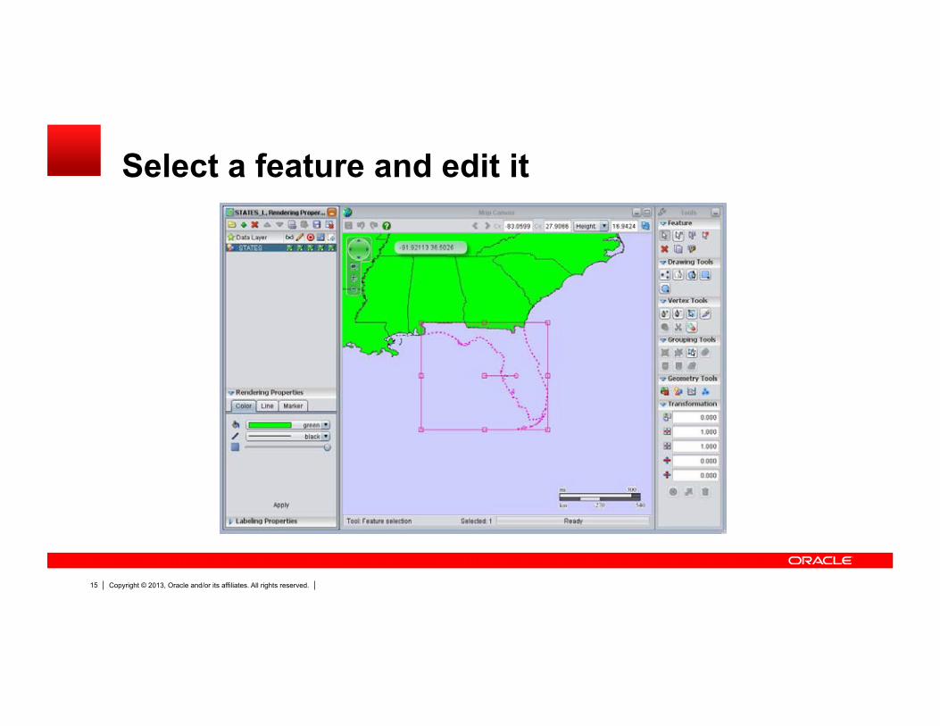
Map data editing
A web-based spatial data editing tool Supports versioned, concurrent editing through editing “sessions”. Supports geometry model only. Others (topology, ndm editing)
planned for future releases. Supports WFS-T All aspects of an editing session are saved in database Admin tool to visually review editing sessions, as well as resolve
conflicts and merges sessions.
Web-based editor
Copyright © 2013, Oracle and/or its affiliates. All rights reserved. 14
Editor: Select layer
Copyright © 2013, Oracle and/or its affiliates. All rights reserved. 15
Select a feature and edit it
Copyright © 2013, Oracle and/or its affiliates. All rights reserved. 16
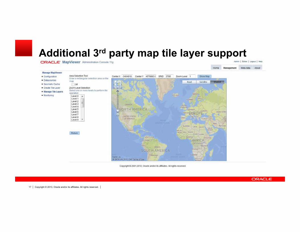
3rd party data sources
MapViewer as a component for consuming and aggregating third party spatial data sources
Support various standards, such as WMTS (Tile Service), TMS, WFS, WMS, GeoJSON, and GeoRSS.
Bundles GDAL /OGR for support of even more external data sources
MapViewer as a mashup component
Copyright © 2013, Oracle and/or its affiliates. All rights reserved. 17
Additional 3rd party map tile layer support
Copyright © 2013, Oracle and/or its affiliates. All rights reserved. 18
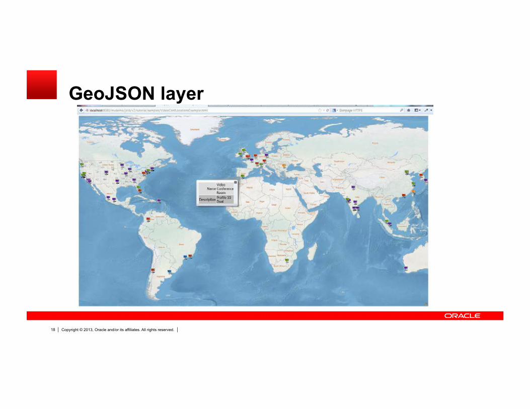
GeoJSON layer
Copyright © 2013, Oracle and/or its affiliates. All rights reserved. 19
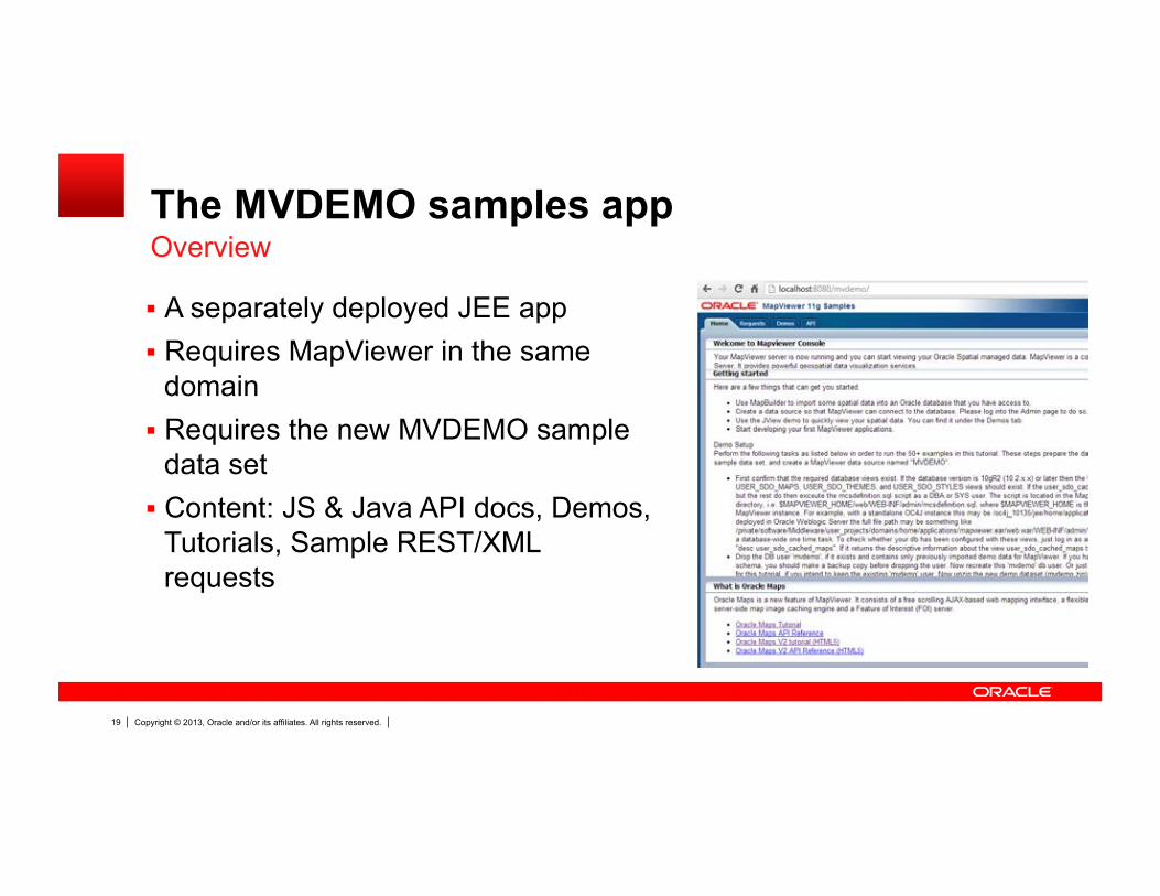
The MVDEMO samples app Overview
A separately deployed JEE app Requires MapViewer in the same
domain Requires the new MVDEMO sample
data set Content: JS & Java API docs, Demos,
Tutorials, Sample REST/XML requests
Copyright © 2013, Oracle and/or its affiliates. All rights reserved. 20
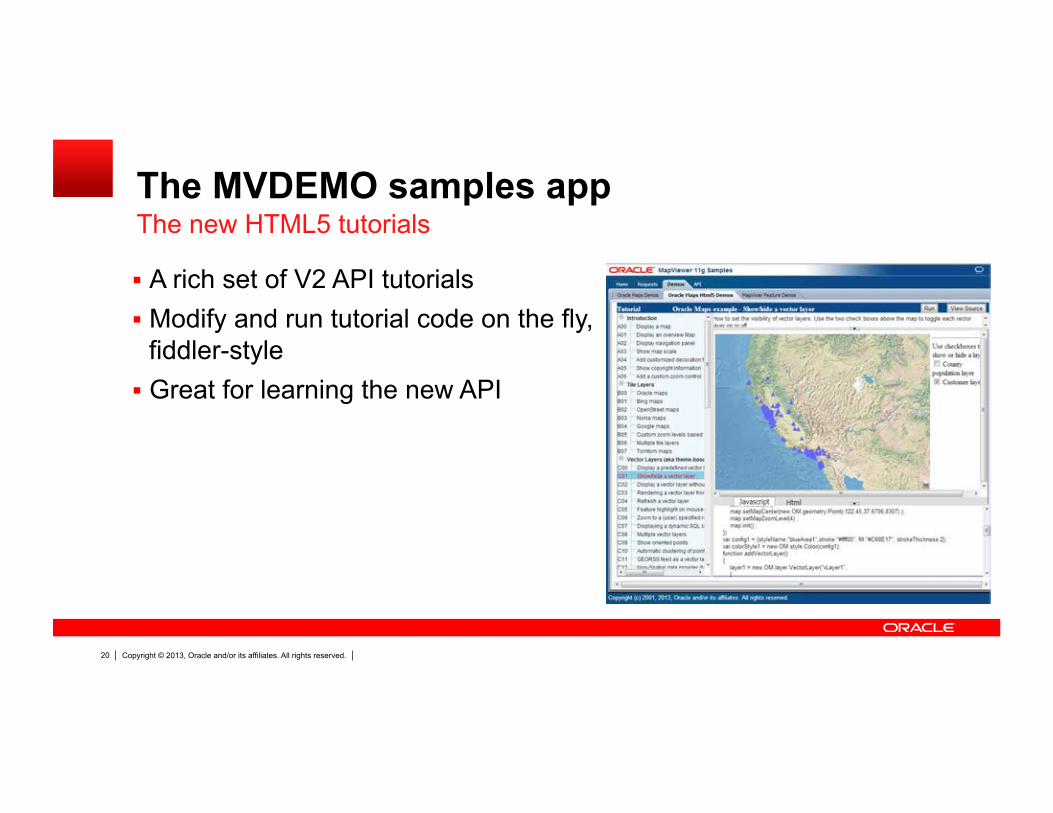
The MVDEMO samples app The new HTML5 tutorials
A rich set of V2 API tutorials Modify and run tutorial code on the fly,
fiddler-style Great for learning the new API
Copyright © 2013, Oracle and/or its affiliates. All rights reserved. 21
Advances with Oracle Database 12c New Spatial Features
Dramatic Performance
Simplified Application Development
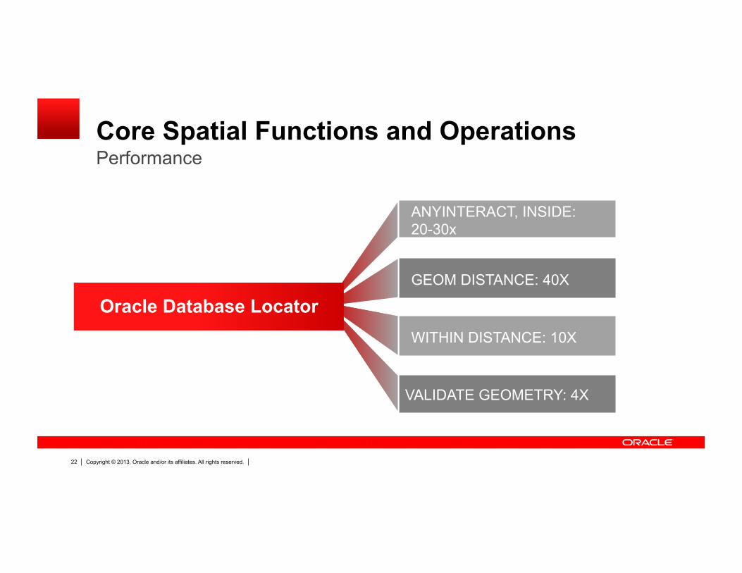
Copyright © 2013, Oracle and/or its affiliates. All rights reserved. 22
Core Spatial Functions and Operations Performance
VALIDATE GEOMETRY: 4X
ANYINTERACT, INSIDE: 20-30x
GEOM DISTANCE: 40X
WITHIN DISTANCE: 10X
Oracle Database Locator
Copyright © 2013, Oracle and/or its affiliates. All rights reserved. 23
OPTIMIZED METADATA QUERIES
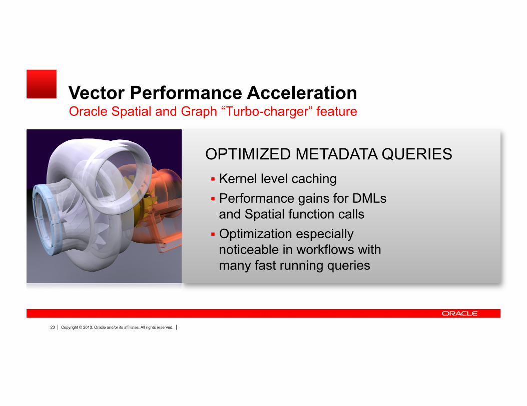
Vector Performance Acceleration
Kernel level caching Performance gains for DMLs
and Spatial function calls Optimization especially
noticeable in workflows with many fast running queries
Oracle Spatial and Graph “Turbo-charger” feature
Copyright © 2013, Oracle and/or its affiliates. All rights reserved. 24
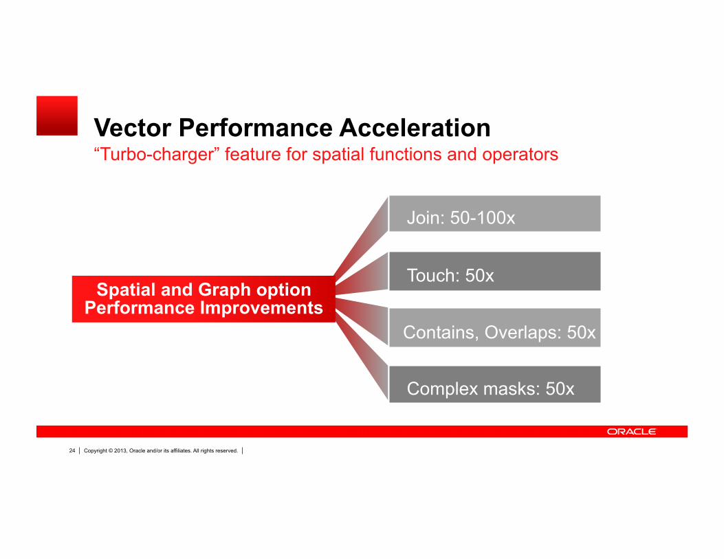
Vector Performance Acceleration “Turbo-charger” feature for spatial functions and operators
Join: 50-100x
Touch: 50x
Complex masks: 50x
Spatial and Graph option Performance Improvements
Contains, Overlaps: 50x

Copyright © 2013, Oracle and/or its affiliates. All rights reserved. 25
Vector Performance Acceleration “Turbo-charger” feature for spatial functions and operations
GEOM.relate: 5-10x
DML single insert: 3x
Coordinate System Transformations: 40-50%
General DML operations: 30-50%
Spatial Performance Improvements

Copyright © 2013, Oracle and/or its affiliates. All rights reserved. 26
New PointInPolygon Function
SDO_PointInPolygon Function – Arg1: cursor that select a set of points
Very flexible as the data can come from a table, or result of another query E.g., select * from point_data where c1 < 10 and c2 > 100 …
– Arg2: is any Polygon geometry – Returns all the points that are inside the polygon
Useful when large number of points have to be classified based on a set of polygons
Parallel enabled Can easily process 30K points per second in serial case
Fast Point in Polygon without Spatial index

Copyright © 2013, Oracle and/or its affiliates. All rights reserved. 27
• MANY RASTER FUNCTIONS CAN PARALLELIZE • SERIAL OPERATIONS PERFORM UP TO 3X FASTER • SCALES TO OVER 100X FASTER ON HIGHLY PARALLEL SYSTEMS
Parallel Raster Operations

Copyright © 2013, Oracle and/or its affiliates. All rights reserved. 28
Virtual Mosaic of collections of any georeferenced GeoRaster objects
Advanced spatial queries and on-the-fly transformation and mosaics
Raster Algebra operations to create new map products
Image Processing: Masking, stretching, segmentation, rectification
In Database Processing
Virtual Mosaic and Image Processing
Mosaic of Landsat Images

Copyright © 2013, Oracle and/or its affiliates. All rights reserved. 29
Real World Feature Modeling in NDM Graph
Feature Representation Network Representation

Copyright © 2013, Oracle and/or its affiliates. All rights reserved. 30
10 PM
8 AM
Traffic Patterns – Record historical travel – Based on time of day and day of the
week NDM can use traffic patterns to compute
shortest paths Support NAVTEQ Traffic Patterns format
out of the box
Temporal Modeling/Analysis
Network Data Model Graph

Copyright © 2013, Oracle and/or its affiliates. All rights reserved. 31
Each mode (car, bus, rail, bike, etc) modeled as a separate network
Single logical network represents all modes of transportation
Transition nodes where networks meet NDM APIs can specify the modes Out of the box support for transit data
published by transit authorities
Multi-Modal Routing
Train & Bus
Bus Only
Network Data Model Graph

Copyright © 2013, Oracle and/or its affiliates. All rights reserved. 32
Millions of customers, find closest store within a specified drive time
Single database query to find closest store and drive time/distance for each customer
Customers geocode as based on graph segment
Network Buffer generates all possible paths
Big Data Analysis
Large Scale Drive Time/Distance Analysis
Store Location Customer Location
Network Data Model Graph

Copyright © 2013, Oracle and/or its affiliates. All rights reserved. 33
Performance and In-Database Analysis RDF Semantic Graph
SPARQL 1.1
Named Graphs
Standard Mechanism to distinguish graphs models in large graphs.
Reasoning Faster, more efficient, and secure reasoning engine
GeoSPARQL
Richer query language with improved path analysis. Less application code.
Query language for spatial “linked data.” Less application code.

Copyright © 2013, Oracle and/or its affiliates. All rights reserved. 34
Summary of New Spatial & Graph Features
Vector Performance Acceleration
High-performance point-in-polygon processing
Parallel GeoRaster and Enhanced Raster Operations
NDM: Feature modeling, multi-modal, temporal
RDF: views, enhanced reasoning & security, performance

Copyright © 2013, Oracle and/or its affiliates. All rights reserved. 35
Oracle Exadata Extreme Scalability for Millions of Spatial Objects
Millions of spatial objects evaluated in minutes
– Point in polygon analysis – Polygon to polygon analysis – Deviation from route – Distance covered
Millions of Spatial objects ingested in minutes – Weather readings – Traffic readings – Sensor readings

Copyright © 2013, Oracle and/or its affiliates. All rights reserved. 36
Oracle Exadata High Performance RDF Graph Workloads
RDF Semantic Graph is designed for the Exadata architecture
3x faster inferencing and querying Parallel load, inference and query Inferencing accelerated with Hybrid
Columnar Compression Queries faster with OLTP index
compression on B-tree indexes

Copyright © 2013, Oracle and/or its affiliates. All rights reserved. 37
Oracle Spatial and Graph
Proven, industry-leading technology
Dramatically improved performance
Simpler, more scalable applications
Engineered for Exadata
HTML5 support in MapViewer

Copyright © 2013, Oracle and/or its affiliates. All rights reserved. 38
Resources
Oracle Technology Network Get software downloads, sample code, tech info, updates, documentation, partner resources
– Oracle Spatial and Graph www.oracle.com/technetwork/database-options/ spatialandgraph/overview/spatialfeatures-1902020.html
– Oracle Fusion Middleware MapViewer www.oracle.com/technetwork/middleware/mapviewer/

Copyright © 2013, Oracle and/or its affiliates. All rights reserved. 39
User Groups & Certification Oracle Spatial & Graph Special Interest Group:
Connect and exchange knowledge with the user community – Meet the SIG Board at OOW: Wed 9/25, 2:00-3:00pm
OTN Lounge, Moscone South Lobby – Join our groups: LinkedIn, Google+, IOUG SIG – Visit OTN Spatial – Community
Search online for “Oracle Spatial and Graph Community” – Email [email protected]
Individual Certification, Partner Specialization - www.oracle.com/technetwork/database-options/
spatialandgraph/learnmore/spatial-partners-423197.html - Talk to Oracle team this week at OPN Lounge or
Oracle Spatial & Graph demopod in Moscone South

Copyright © 2013, Oracle and/or its affiliates. All rights reserved. 40
Spatial and Graph at OOW 2013 - Sessions Date/Time Title Location Monday, Sept 23
1:45 PM - 2:45 PM Best Development Practices with Maps, Spatial, and Graph Analytics Marriott Marquis - Golden Gate C2
3:15 PM - 4:15 PM Latest Spatial Features in Oracle Database 12c Moscone South - 303
4:45 PM - 5:45 PM Fast Data with Oracle Event Processing Moscone North - 130
4:45 PM - 5:45 PM Newest Graph Features in Oracle Database 12c Moscone South - 303
7:15 PM - 8:00 PM What’s New in Location Analytics: HTML5, Mobile, and Spatial in Oracle Database 12c [Birds of a Feather]
Marriott Marquis - Foothill G
Tuesday, Sept 24
12:00 PM - 1:00 PM Enhancing City Public Transportation St. Francis - Elizabethan C/D
Wednesday, Sept 25
11:45 AM -12:45 PM Customer Experiences with Oracle Spatial and Graph Moscone South - 300

Copyright © 2013, Oracle and/or its affiliates. All rights reserved. 41
Spatial and Graph at OOW 2013 – Demos Date/Time Title Location
Monday - Wednesday Oracle's Spatial Technologies Moscone South Exhibition Hall Oracle Database DEMOgrounds (Left - SL-070)
Monday - Wednesday Graph Database for the Enterprise Moscone South Exhibition Hall Oracle Database DEMOgrounds (Left - SL-069)
Mon, 12:00-12:20pm Wed, 10:30-10:50am
Location-Based Services (Big Data Theater) Moscone South Exhibition Hall Room 106 - Industry Showcase Theater
Partners Date/Time Title Location
Monday - Wednesday HERE, a Nokia Business Moscone South Exhibition Hall Booth #2232
Monday - Wednesday Esri Moscone South Exhibition Hall Booth #640

Copyright © 2013, Oracle and/or its affiliates. All rights reserved. 42
Spatial and Graph at OOW 2013 – Hands On Lab Date/Time Title Location Tuesday, Sept 24
10:30 AM - 11:30 AM Fast Data Best Practices and Design Patterns with Oracle Event Processing Marriott Marquis - Salon 12/13
Meet-Ups Date/Time Title Location Wednesday, Sept 25
2:00 PM - 3:00 PM Oracle Spatial and Graph Special Interest Group Meet-Up OTN Lounge - Moscone South Lobby
2:00 PM - 3:00 PM RDF Graph User Meet-Up with Oracle Product Team OTN Lounge - Moscone South Lobby

Copyright © 2013, Oracle and/or its affiliates. All rights reserved. 43
Graphic Section Divider

Copyright © 2013, Oracle and/or its affiliates. All rights reserved. 44