1 Climate recap and outlook Nate Mantua, PhD University of Washington Center for Science in the...
33
1 Climate recap and outlook Nate Mantua, PhD University of Washington Center for Science in the Earth System - Climate Impacts Group Kelso, WA October 3, 2006
-
date post
19-Dec-2015 -
Category
Documents
-
view
214 -
download
0
Transcript of 1 Climate recap and outlook Nate Mantua, PhD University of Washington Center for Science in the...

11
Climate recap and outlookClimate recap and outlook
Nate Mantua, PhDUniversity of Washington
Center for Science in the Earth System - Climate Impacts Group
Kelso, WA October 3, 2006
Nate Mantua, PhDUniversity of Washington
Center for Science in the Earth System - Climate Impacts Group
Kelso, WA October 3, 2006

The CSES - Climate Impacts GroupThe CSES - Climate Impacts Group
•Goal: help the Pacific Northwest become more resilient to climate variations and climate change
• Supported by NOAA Climate Program Office as part of the Regional Integrated Science and Assessments (RISA) program
•Goal: help the Pacific Northwest become more resilient to climate variations and climate change
• Supported by NOAA Climate Program Office as part of the Regional Integrated Science and Assessments (RISA) program
http://cses.washington.edu/cig/

33
global temperatures continue to run highglobal temperatures continue to run high
http://www.ncdc.noaa.govhttp://www.ncdc.noaa.gov

44
The pattern is globalThe pattern is global
http://www.ncdc.noaa.govhttp://www.ncdc.noaa.gov

55
Current droughtCurrent drought


77
Accumulated Precip for the past yearAccumulated Precip for the past year
Source:http://www.cpc.ncep.noaa.gov/products/global_monitoring/precipitation/
northwest_1yrprec.shtml

88
Accumulated Precip for the past yearAccumulated Precip for the past year
Source:http://www.cpc.ncep.noaa.gov/products/global_monitoring/precipitation/
northwest_1yrprec.shtml

99
Accumulated Precip for the past yearAccumulated Precip for the past year
Source:http://www.cpc.ncep.noaa.gov/products/global_monitoring/precipitation/
northwest_1yrprec.shtml

1010
Accumulated Precip for the past yearAccumulated Precip for the past year
Source:http://www.cpc.ncep.noaa.gov/products/global_monitoring/precipitation/
northwest_1yrprec.shtml

1111

1212
Daily TemperaturesDaily Temperatures
+0.90ºC+0.90ºC +0.81ºC+0.81ºC

1313
2006 snow pack2006 snow pack
• Warm weather in May started a rapid melt of the PNWs abundant snow pack
• Warm weather in May started a rapid melt of the PNWs abundant snow pack

1414
Our hot-dry summerOur hot-dry summer
• For OR-ID-WA, May-June-July 2006 was warmest on record (back to 1895)
• June-July-August was 3rd warmest on record
• For OR-ID-WA, May-June-July 2006 was warmest on record (back to 1895)
• June-July-August was 3rd warmest on record

1515
28-day mean stream flow from the USGS28-day mean stream flow from the USGS

1616
Oct 1st estimated soil moisture percentilesOct 1st estimated soil moisture percentiles
• Courtesy of Andy Wood, University of Washington, data and images are available at
http://www.hydro.washington.
edu/forecast/monitor
• Courtesy of Andy Wood, University of Washington, data and images are available at
http://www.hydro.washington.
edu/forecast/monitor

1717
Last year’s outlookLast year’s outlook
• The ENSO outlook: La Nada (“normal”)
• PNW climate outlook: odds favoring a “warm” winter and spring
• The ENSO outlook: La Nada (“normal”)
• PNW climate outlook: odds favoring a “warm” winter and spring

1818
IRI ENSO Forecast SummaryIRI ENSO Forecast Summary
• Forecasts from October 2005 called for Nino34 ranging from -0.2 to +0.6, with an average of ~+0.2
• Forecasts from October 2005 called for Nino34 ranging from -0.2 to +0.6, with an average of ~+0.2
http://iri.columbia.edu/climate/ENSO/currentinfo/
SST_table.html#figure

1919
Oct 12, 2005 NOAA NCEP ENSO forecastsOct 12, 2005 NOAA NCEP ENSO forecasts
http://www.cpc.ncep.noaa.gov/products/analysis_monitoring/lanina/ensoforecast.html

2020
Nov-Mar 2006 SST anomalies: a mild La Niña for the Pacific
Nov-Mar 2006 SST anomalies: a mild La Niña for the Pacific

2121
Last year’s forecast (from Oct 20)Last year’s forecast (from Oct 20)
DJF temp 2005-06
FMA temp 2006

2222
Last year’s precipitation forecasts for 2005-2006: issued Oct 20 2005Last year’s precipitation forecasts for 2005-2006: issued Oct 20 2005

2323
The forecastThe forecast
Cartoon obtained from:http://www.cartoonstock.com/directory/c/crystal_ball.aspCartoon obtained from:http://www.cartoonstock.com/directory/c/crystal_ball.asp
Forecasts … ?

2424
Global Ocean Surface Temperatures: July 2-September 30 2006Global Ocean Surface Temperatures: July 2-September 30 2006

2525
The tropical ocean is warmThe tropical ocean is warm
http://www.cpc.ncep.noaa.gov/products/analysis_monitoring/lanina/l

2626
El Niño is simmeringEl Niño is simmering
• Tropical ocean temperatures have been warmer than average since mid-May, and have already crossed the “El Niño” threshold
• Tropical ocean temperatures have been warmer than average since mid-May, and have already crossed the “El Niño” threshold

2727
The latest ENSO forecastsThe latest ENSO forecasts
See http://iri.columbia.edu/climate/ENSOSee http://iri.columbia.edu/climate/ENSO
European Center
NOAA NCEP
Forecast summaries

2828

2929
Average El Niño winter precip: 1916-2003Average El Niño winter precip: 1916-2003
• Dry on the western, wetter slopes, slightly wet or near average for the “rainshadow” areas
From http://www.cses.washington.e
du/cig/maps
• Dry on the western, wetter slopes, slightly wet or near average for the “rainshadow” areas
From http://www.cses.washington.e
du/cig/maps

3030
Pacific Ocean Outlook SummaryPacific Ocean Outlook Summary• Current forecasts rate weak-to-moderate El
Niño as most likely situation for 2006/07• PDO: A simple forecast with skill relies on
“PDO persistence + ENSO influence” (see
Newman et al. (2003), J. Climate)• Expect weak warm phase PDO conditions for 2006/7• PDO = +0.3 to +0.8 st devs for Nino34 = +0.5 to +1.5
• A Note on Last year…
• Current forecasts rate weak-to-moderate El Niño as most likely situation for 2006/07
• PDO: A simple forecast with skill relies on “PDO persistence + ENSO influence” (see
Newman et al. (2003), J. Climate)• Expect weak warm phase PDO conditions for 2006/7• PDO = +0.3 to +0.8 st devs for Nino34 = +0.5 to +1.5
• A Note on Last year…
(July-June averages)
Forecast Observed
Nino3.4 index -0.2 to +0.6 -0.14PDO index +0.2 to +.6 +0.12

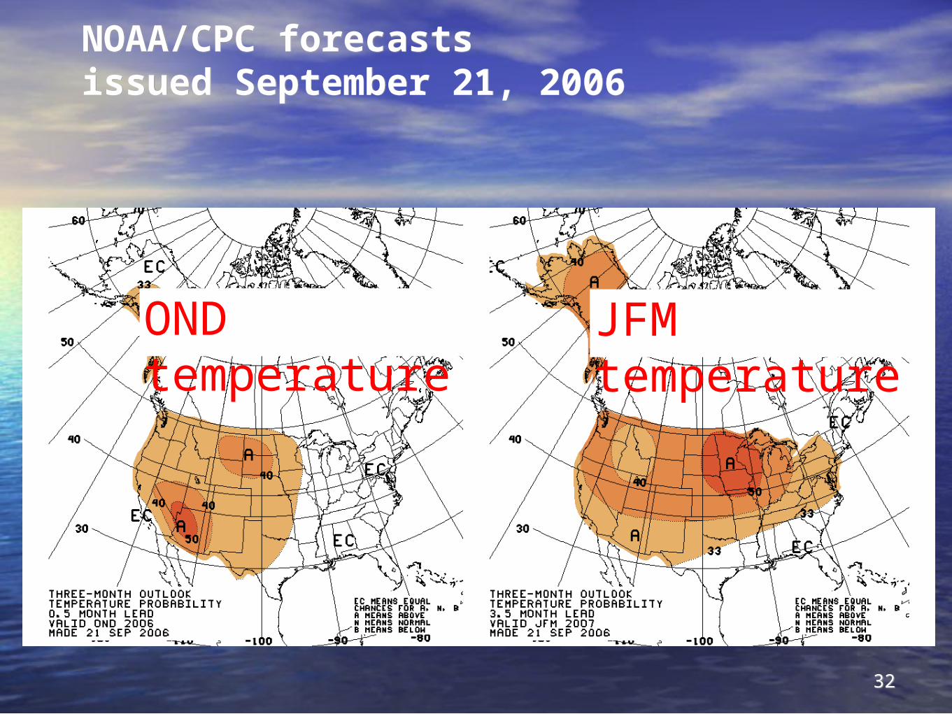
NOAA/CPC forecasts issued September 21, 2006NOAA/CPC forecasts issued September 21, 2006
OND precip JFM precip
http://cpc.ncep.noaa.govhttp://cpc.ncep.noaa.gov
3232
http://cpc.ncep.noaa.govhttp://cpc.ncep.noaa.gov
NOAA/CPC forecasts issued September 21, 2006NOAA/CPC forecasts issued September 21, 2006
OND temperature JFM temperature

3333
The Bottom lineThe Bottom line
• a weak to moderate El Niño is likely for the next 2-3 seasons•because of trends and expectations for a weak to moderate intensity El Niño, above-average fall/winter/spring temperatures are likely• El Niño also tilts the odds in favor of a dry fall/winter and below average end-of-season snow pack
• a weak to moderate El Niño is likely for the next 2-3 seasons•because of trends and expectations for a weak to moderate intensity El Niño, above-average fall/winter/spring temperatures are likely• El Niño also tilts the odds in favor of a dry fall/winter and below average end-of-season snow pack
See http://www.cpc.ncep.noaa.gov