1 – Revision of Bangalore’s CDP GIS Land use 2 – Spatial ...Bangalore Metropolitan Area...
14
1 1 GROUPE FIT EILAT 2009 FIG Working week Bangalore, looking back on the experience Landsat - 1991 The approach The Scenarios Results & Future perspectives What do we mean by metropolis? 2 GROUPE FIT EILAT 2009 FIG Working week Bangalore, looking back on the experience Landsat - 1991 The approach 3 GROUPE FIT EILAT 2009 FIG Working week • Duration: 24 months, • Team: More than 90 people were mobilised: Urban planner, architects, economists, demographers, geographers, engineers transport experts, cartographer, GIS engineers. • Budget: 4.6 M€ € & 0.4 million € € in the form of BDA employees made available by the client, the BDA. • IT equipment: 0.56 M€ € • Services: 4.44 M€ € . THE MSDI PROJECT THE MSDI PROJECT 1 1 – Revision of Bangalore Revision of Bangalore’ s CDP s CDP – Realisation of the Urban Master plan – Realisation of the Land use map – Definition and elaboration of the Urban Regulatory framework 2 2 – Spatial Infrastructure: Spatial Infrastructure: – Digital large scale Land use/land pattern map, – Implementation of urban spatial repository – Development and diffusion of GIS-enabled applications for domain expertise • Multi-usage Urban database • Interactive spatial terminal • Web-base urban planning tools • Land use management simulation tools • Project management tools for BDA housing programs, • Building permit management and administration tools 3 3 – Local capacity building & training Local capacity building & training – Urban planning – City management –Mapping - GIS 4 GROUPE FIT EILAT 2009 FIG Working week 1:50,000 GIS 0.66 cm Land use Large scale city map High resolution satellite imagery 1/10 000 1/5 000 Ground surveys Thematic data AN INTEGRATED APPROACH AN INTEGRATED APPROACH 5 GROUPE FIT EILAT 2009 FIG Working week METHODOLOGY Urban proposal Spatial strategy Land use regulation S + 8 m S + 11 m S + 17 m CDP REVISION : CDP REVISION : A A “Top to bottom Top to bottom” approach approach Training Institutional Strengthening 6 GROUPE FIT EILAT 2009 FIG Working week Large scale r efer ence map Tra ining & Inst itutiona l str engt h ening Geographical informat ion (GIS) & Appli cations Urban planning docu ments CDP REVISION CDP REVISION- DELIVERABLES DELIVERABLES
Transcript of 1 – Revision of Bangalore’s CDP GIS Land use 2 – Spatial ...Bangalore Metropolitan Area...

1
1GROUPE FIT
EILAT 2009 FIG Working week
Bangalore,
looking back on the experience
Landsat - 1991
The approach
The Scenarios
Results & Future perspectives
What do we meanby metropolis?
2GROUPE FIT
EILAT 2009 FIG Working week
Bangalore, looking back on the experience
Landsat - 1991
The approach
3GROUPE FIT
EILAT 2009 FIG Working week
• Duration: 24 months, • Team: More than 90
people were mobilised: Urban planner, architects, economists, demographers, geographers, engineers transport experts, cartographer, GIS engineers.
• Budget: 4.6 M€€ & 0.4 million €€ in the form of BDA employees made available by the client, the BDA.
• IT equipment: 0.56 M€€• Services: 4.44 M€€ .
THE MSDI PROJECTTHE MSDI PROJECT
1 1 –– Revision of BangaloreRevision of Bangalore’’s CDP s CDP – Realisation of the Urban Master plan– Realisation of the Land use map– Definition and elaboration of the Urban Regulatory framework
2 2 –– Spatial Infrastructure: Spatial Infrastructure: – Digital large scale Land use/land pattern map,
– Implementation of urban spatial repository
– Development and diffusion of GIS-enabled applications for domain expertise
• Multi-usage Urban database
• Interactive spatial terminal
• Web-base urban planning tools
• Land use management simulation tools
• Project management tools for BDA housing programs,
• Building permit management and administration tools
3 3 –– Local capacity building & trainingLocal capacity building & training– Urban planning – City management –Mapping - GIS
4GROUPE FIT
EILAT 2009 FIG Working week
1:50
,000
GIS
0.6
6 c
m
Land u
seLa
rge s
cale
ci
ty m
ap
Hig
h
reso
luti
on
sate
llit
e
imag
ery
1/1
0 0
00
1/5
000
Gro
und
surv
eys
Th
emat
ic
data
AN INTEGRATED APPROACHAN INTEGRATED APPROACH
5GROUPE FIT
EILAT 2009 FIG Working week
METHODOLOGY
Urb
an p
ropo
sal
Spat
ial st
rate
gy
Land
use
re
gula
tion
S + 8 m
S + 11 m
S + 17 m
CDP REVISION :CDP REVISION :
A A ““Top to bottomTop to bottom”” approachapproach
Tra
inin
g In
stit
utio
nal
Stre
ngth
enin
g
6GROUPE FIT
EILAT 2009 FIG Working week
Larg
e sca
lere
feren
cemap
Trai
ning
& In
stitu
tiona
l stre
ngth
enin
g
Geographical information (GIS) & Applications
Urban planning documents
CDP REVISIONCDP REVISION-- DELIVERABLESDELIVERABLES

2
7GROUPE FIT
EILAT 2009 FIG Working week
populationpopulation
Educ
atio
n
Educ
atio
n
NITC
NITC
Gree
n
Gree
n be
ltbe
ltCBD
CBD
TransportTransport
Was
te
Was
te
InfrastructureInfrastructure
FacilitIesFacilitIes
HousingHousing
Trad
e
Trad
e& &
Indu
stry
Indu
stry
Land
&
Land
&
Prop
erty
Prop
erty
adm
instra
tion
adm
instra
tion
Shan
ty
Shan
tyto
wns
towns
InformalInformaleconomyeconomy
WaterWater
HeritageHeritage TourismTourism
CDP REVISIONCDP REVISION-- TOPICS INVOLVEDTOPICS INVOLVED
PopulationPopulation
8GROUPE FIT
EILAT 2009 FIG Working week
Bangalore,
looking back on the experience
Landsat - 1991
What do we meanby metropolis?
9GROUPE FIT
EILAT 2009 FIG Working week
The Territory
Geography
10GROUPE FIT
EILAT 2009 FIG Working week
Bangalore Metro Area
Bangalore Urban Area
Bangalore Metropolitan Area
Geography
1306 km2 – Pop 63 lakhs
501 km – Pop 58 lakhs
11GROUPE FIT
EILAT 2009 FIG Working week
A high density unequally distributed along the city
BangaloreShanghaiMoscowRomaBerlin
SHANGHAI
244 km2
7,397,000 population
303 inhabitants/ha
MOSCOW
470 km2
8,543,000 population
181 inhabitants/ha
Urban shape
Population
12GROUPE FIT
EILAT 2009 FIG Working week
Urban Area 532km2
AtlantaBarcelona
Barcelona (Spain):2.8 million people(2001)162 km2 (built up area)172 inhab/ha
SPOT 5 - April 2003
Bangalore
Territory
Urban Footprints

3
13GROUPE FIT
EILAT 2009 FIG Working week
Bangalore City Corporation
Green belt
Theoretical border of CDP
Which territories?
14GROUPE FIT
EILAT 2009 FIG Working week
Which project?
15GROUPE FIT
EILAT 2009 FIG Working week
Land use
16GROUPE FIT
EILAT 2009 FIG Working week
ChunchghattaSrinidhi layout
KIADB industrial area
Coffee board layoutChamundeswari layout
Judicial colony
Kareemsab nagarChamundi nagar
Peenya industrial estate
Rajarajeshwari nagar
PuttenahalliJaraganahalli Mangamana palaya
Hongasandara
Sadaramangala industrial area
Marattahalli extension
Duravani nagar
Gokula extension
HMT Layout
Banasavadi
Magadi road -Chord road layout
Azad nagar
Banashankari 1st stage
Banashankari 2nd stage
Indiranagar 1st stage
Koramangala 3rd block
Chickpete
Cantonment
Halsur
Domlur
Koramangala
Frazer town
Basavanagudi
Malleshvaram
Mattadahalli
Vyalikaval Maruti seva Nagar
Golf course
Territory
Evolution of urban sprawl
Kengeri satellite Town
Vallabahai Layout
BHEL layout
AECS LAYOUT
20102010 ??20032003458 km²6,16 M/inh
19951995295 km²4,1M/inh
19731973160 km²1,65 M/inh
1884188456 km²
180718074 km²0,1 M/inh
163016302 km²0,1 M/inh
19481948160 km²0,77 M/inh
Chamarajpet
Sheshadripuram
Benson TownCleveland Town
ShuleRichmond TownBinny Mill
Minerva Mill
Indian institute of science
Devarjeevanahalli
Cox TownSriramapura
Vishveshwarapuram
Tasker Town
ShankarapuraGavipuram Austin Town
Richards Town
VishweswhariahLayout
17GROUPE FIT
EILAT 2009 FIG Working week
ValleyValley
HousingHousing estateestate
ECOLOGYECOLOGYTANKTANKKODIGEHALLI KEREKODIGEHALLI KERE
TANKTANK
HEBBALHEBBAL
BarhatBarhat ElectronicElectronic
Ring RoadRing Road
18GROUPE FIT
EILAT 2009 FIG Working week
II - ANALYSIS
II - DIAGNOSIS
4
19GROUPE FIT
EILAT 2009 FIG Working week
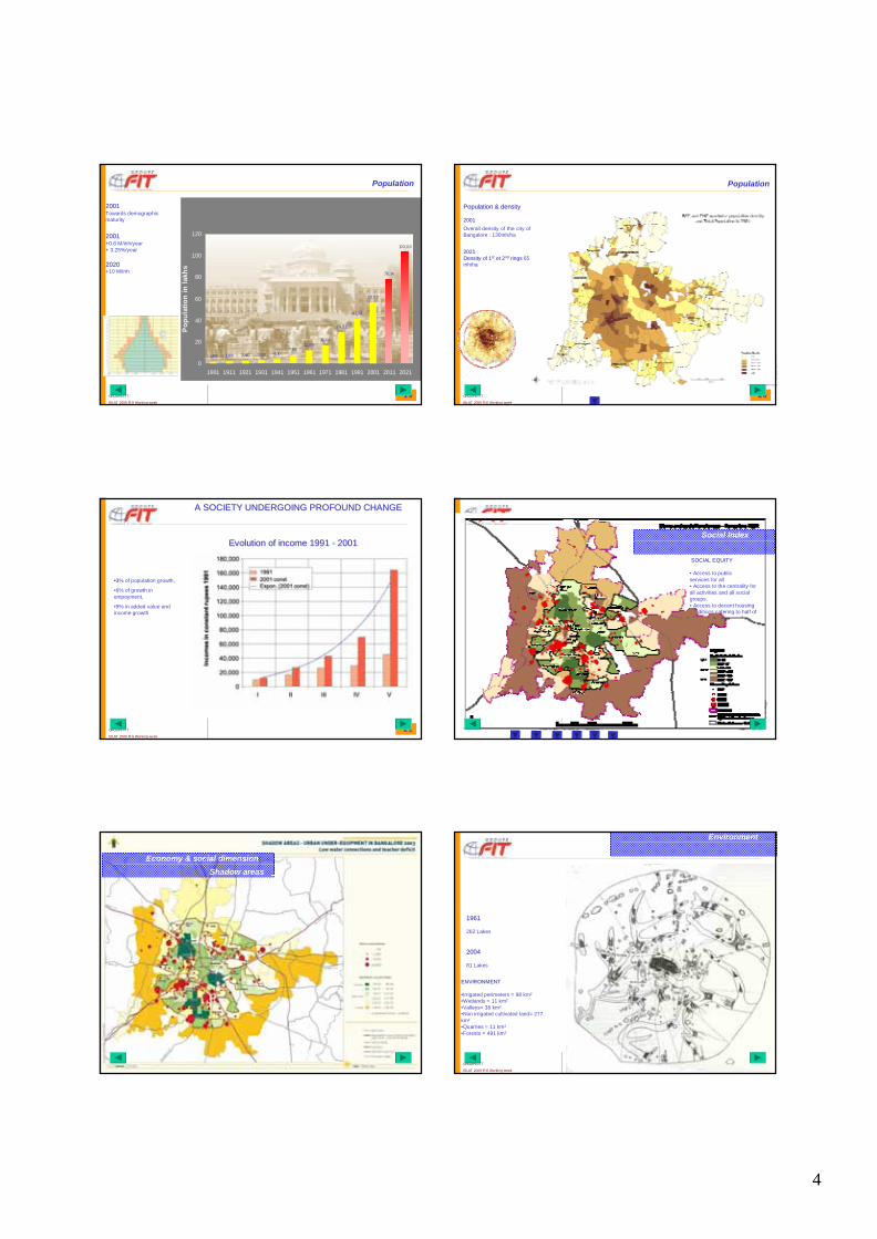
20012001Towards demographicmaturity
20012001+0.8 M/inh/year+ 3.25%/year
20202020+10 M/inh
1,63 1,89 2,40 3,09 4,107,86
12,0616,64
29,21
41,30
56,86
78,14
103,00
0
20
40
60
80
100
120
1901 1911 1921 1931 1941 1951 1961 1971 1981 1991 2001 2011 2021
Census period
Po
pu
lati
on
in
lak
hs
Population
20GROUPE FIT
EILAT 2009 FIG Working week
Population & densityPopulation & density
20012001
Overall density of the city of Bangalore : 130inh/ha
20212021Density of 1Density of 1stst et 2et 2ndnd ringsrings 65 inh/ha
Population
21GROUPE FIT
EILAT 2009 FIG Working week
A SOCIETY UNDERGOING PROFOUND CHANGEA SOCIETY UNDERGOING PROFOUND CHANGE
••33% of population growth,
•6% of growth in empoyment,
•9% in added value andincome growth
Evolution of income 1991 Evolution of income 1991 -- 20012001
22GROUPE FIT
EILAT 2009 FIG Working week
SOCIAL EQUITYSOCIAL EQUITY
• Access to public services for all• Access to the centrality for all activities and all social groups. • Access to decent housing conditions catering to half of the population.
Social Index
23GROUPE FIT
EILAT 2009 FIG Working week
Economy & social dimension
Shadow areas
24GROUPE FIT
EILAT 2009 FIG Working week
Environment
ENVIRONMENTENVIRONMENT
•Irrigated perimeters = 98 km²•Wetlands = 11 km²•Valleys= 38 km²•Non irrigated cultivated land= 277 km²•Quarries = 11 km²•Forests = 491 km²
20042004
81 Lakes
19611961
262 Lakes

5
25GROUPE FIT
EILAT 2009 FIG Working week
Environment
Valleys & retenues collinaires
26GROUPE FIT
EILAT 2009 FIG Working week
Education Education •2917 schools•468 colleges•9 universities
•A deficit of about 10%
Social Infrastructure
Education
27GROUPE FIT
EILAT 2009 FIG Working week
Infant mortality: 24 for 1000 birth,
•753 health centers
Social Infrastructure
Health – Number of beds
28GROUPE FIT
EILAT 2009 FIG Working week
Transport Facts & Figures•1991 : 0,68 M/vehicules•2003 : 1,83 lakh M/vehicules,•Growth => 8.6%/year
BusBus 2W Walk 3W Car Chartered Cycle Others
Mode of Transport
0
5
10
15
20
25
30
35
40
Pe
rce
nta
ge
TRANSPORTTRANSPORT
29GROUPE FIT
EILAT 2009 FIG Working week
TYPES OF URBANISASTION TYPES OF URBANISASTION & HOUSING& HOUSING
30GROUPE FIT
EILAT 2009 FIG Working week
Vacant Area BMA185 km²
Vacant Area BCC20,6 km²
Land & Property
Urban Sprawl

6
31GROUPE FIT
EILAT 2009 FIG Working week
-130 km2,
-24% of the urban area
-Encroaching the green belt by 33km2
- Fulfilling the Land requirement until 2014,
- Strong marker of institutional malfunctioning
Land & Property
Informal developments
32GROUPE FIT
EILAT 2009 FIG Working week
Economy
An incubator for economic acitivty
33GROUPE FIT
EILAT 2009 FIG Working week
Bangalore,
looking back on the experience
Landsat - 1991
Scenarios
34GROUPE FIT
EILAT 2009 FIG Working week
THE MAJOR FACTS OF THE EQUATION…
…200 km² of developed but vacant land => needs for 2015
…Rail - Road
…partial, total retreat of the green belt …
…Population +200 000 / year
…Water scarcity?
35GROUPE FIT
EILAT 2009 FIG Working week
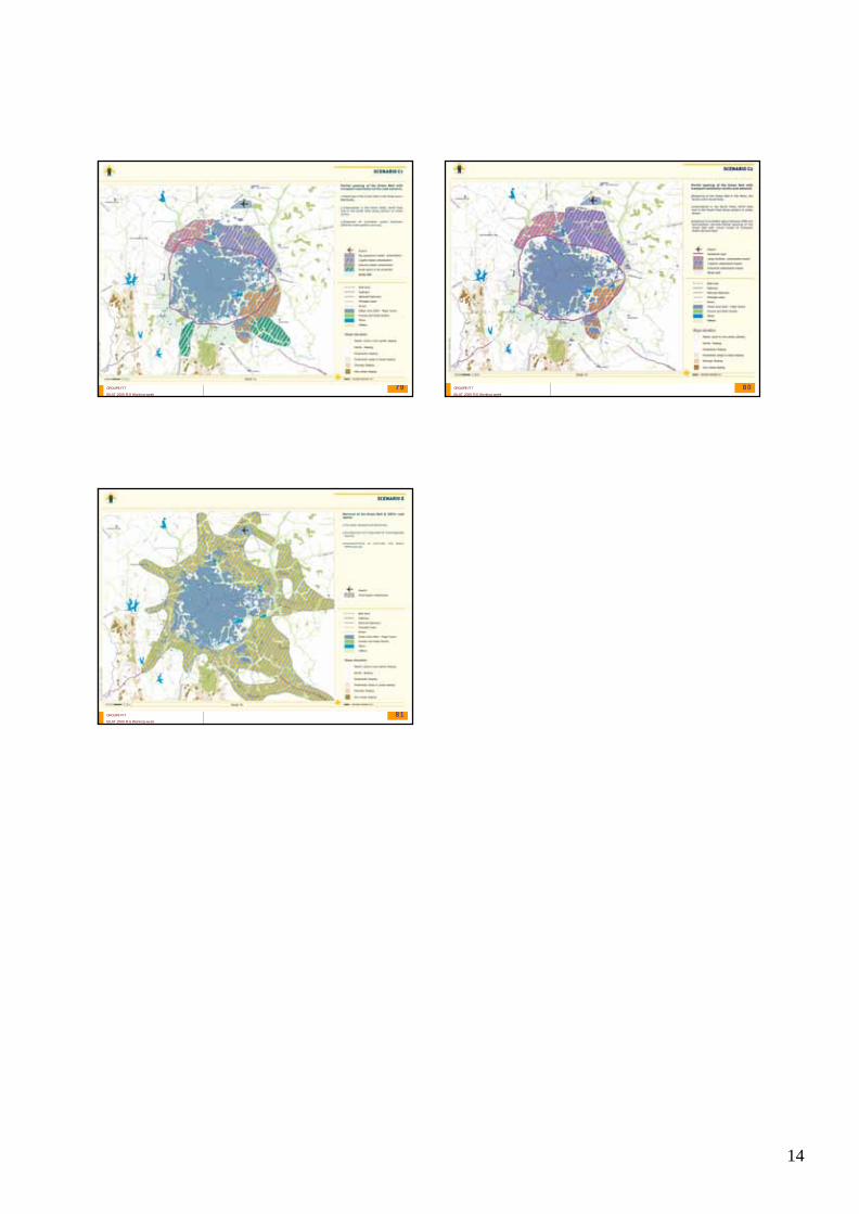
Water flowThe NITC corridorThe integrated city
Options for urban growth
Preliminary proposals
36GROUPE FIT
EILAT 2009 FIG Working week
Scenario C1
Scenario B
Options for Growth
Preliminary proposal
Scenario DScenario E
Scenario C2

7
37GROUPE FIT
EILAT 2009 FIG Working week
SUST
ANAI
BLE
ECO
NO
MIC
GR
OW
TH
SUST
ANAI
BLE
ECO
NO
MIC
GR
OW
THTransportTransport
ITIT
INDUSTRYINDUSTRY
Small Small ScaleScale
IndustryIndustry
LogisticLogistic
SOCIAL
EQUITYY
SOCIAL
EQUITYY
ECOLOGY
ECOLOGY
MASTERMASTER PLAN PLAN –– GOVERNING PRINCIPLESGOVERNING PRINCIPLES
38GROUPE FIT
EILAT 2009 FIG Working week
V – STRATEGY
V- MASTER PLAN & CDP
39GROUPE FIT
EILAT 2009 FIG Working week
40GROUPE FIT
EILAT 2009 FIG Working week
47 PLANNING DISTRICTS
Proposed Land Use Maps
Existing Land Use Maps
Planning District Reports
41GROUPE FIT
EILAT 2009 FIG Working week
VI – COMMUNICATION
VI- PARTICIPATIVE APPROACH
42GROUPE FIT
EILAT 2009 FIG Working week
Public ParticipationPublic Participation

8
43GROUPE FIT
EILAT 2009 FIG Working week
44GROUPE FIT
EILAT 2009 FIG Working week
VII – MANAGEMENT
VII- IMPLEMENTATION
45GROUPE FIT
EILAT 2009 FIG Working week
46GROUPE FIT
EILAT 2009 FIG Working week
Training & Capacity Building
47GROUPE FIT
EILAT 2009 FIG Working week
0 100 200 300 Meters
0 100 200 300 Meters
Old urban Old urban fabricfabric
Plot 30 to 300 m2Density: between 300 to 600 inhab/ha Height: Gf, Gf+1, Gf+2Road Width : from. 8 to 12m
Dense and organic urban fabricMixed area : residential , traditional & commercial activités.
48GROUPE FIT
EILAT 2009 FIG Working week
Mixed areas
Historical zones Cultural Heritage
REVIEWREVIEW
URBAN REGULATIONSURBAN REGULATIONS
GENERAL RECOMMENDATIONSGENERAL RECOMMENDATIONS
Urban fabric under transformation
Poorly serviced areas
• Keep the diversity of the urban functions and pattern, preservation of the mixed areas,• To retain and improve the structure and the general design/appearance of the ward,• Effective management of the Floor Area Ratio,• Adoption of the principle of TDR vested rights (possibility to benefit from an equivalent built up area as previously allowed, in cases of reconstruction).
• Initiate a dedicated, specific & multi sector based survey for these zones,• Promote renewal operations involving the public players (BWSSB, BESCOM….), the BCC, the land lords & end users. Users.• Upgrading of the current infrastructure (Drain, Water supply, sewerage, power, roads.etc)

9
49GROUPE FIT
EILAT 2009 FIG Working week
0 100 200 300 Meters0 100 200 300 Meters
High land use density.Small plots fill up the block and buildings
closely abut the streets.
OLD URBAN FABRICOLD URBAN FABRICShivajiShivaji NagarNagar
50GROUPE FIT
EILAT 2009 FIG Working week
8000 km2
Population: 7,8M
Bangalore a metropolis in the heart of the Deccan Plateau
51GROUPE FIT
EILAT 2009 FIG Working week
Bangalore Metro Area
Bangalore Urban Area
Metropolitain Territory
Geography
1306 km2 – Pop 63 lakhs
501 km – Pop 58 lakhs52GROUPE FIT
EILAT 2009 FIG Working week
Bangalore 6.16 million inhabitants 532 km2
ModelsModels ofof urbanurban developmentdevelopment
Kengeri
Yelahanka
Chickpet
POPULATION DENISTY IN BANGALORE POPULATION DENISTY IN BANGALORE -- 3D3D
54GROUPE FIT
EILAT 2009 FIG Working week
Urban densities Urban densities –– some comparisonssome comparisons
Berlin = 892KM2,
3,45 M/in, 38.8in inh/ha
London = 1579 km 6,68 M inh, 40.5 inh/ha
BANGALORE = 532 km2,
6,1.M Inh - 130 inh/ha
Rome = 1285 km2,
2,8M inh, 21.8 inh/ha

10
URBAN STRUCTURE OF BANGALORE URBAN STRUCTURE OF BANGALORE
56GROUPE FIT
EILAT 2009 FIG Working week
MARKET FORCESMARKET FORCES
57GROUPE FIT
EILAT 2009 FIG Working week
Local revenue Social dimension & Economy
58GROUPE FIT
EILAT 2009 FIG Working week
59GROUPE FIT
EILAT 2009 FIG Working week
3030--6060
100100--180180
6060--8080
8080--100100
00--3030
WATER ISSUESWATER ISSUES
•Between 1991 – 2003 25% Growth in Metered domestic connections•Large disparities within the agglomeration•29% of households still have recourse to public fountains •the ground water table represents about 40% of the water resources.
Connection for 1000 Connection for 1000 inhabinhab
Infrastructure
Water & Sewerage
60GROUPE FIT
EILAT 2009 FIG Working week
Infrastructure
Water

11
61GROUPE FIT
EILAT 2009 FIG Working week
Infrastructure
Sewerage
62GROUPE FIT
EILAT 2009 FIG Working week
Bus
Bus 2W Walk 3W Car Chartered Cycle Others
Mode of Transport
0
5
10
15
20
25
30
35
40
Per
cen
tage
Distribution of Trips
Growth in number of Growth in number of vehiclesvehicles
•1991 : 0,68 M•2003 : 1,83 M•+8.6%/an
Infrastructure
Transport
63GROUPE FIT
EILAT 2009 FIG Working week
Non notified squatter settlements
Unauthorized BDA/KHB/BMP/EWS plots Private builders
I II III IV V
10
20
30
40
50
60
70
Unauthorized revenue sites
%%
Housing Housing 20022002
•Social housing 22.8%, (-20%)
•URS 56% (+32%)
•Private 5.2% (+4.4%)
64GROUPE FIT
EILAT 2009 FIG Working week
65GROUPE FIT
EILAT 2009 FIG Working week
1973 161 km²16, 54,lacs inh
1990304 km²40,86 lacs
2003521 km²65 lacs inh
2010 ?
1990
2003
1973
DEMOGRAPHIC MATURITY
1991199120012001
So urc e : SCE, Ce nsus 2001

12
CHENNAI
CHENNAI
BANGALOREBANGALORE
IT+?IT+?
HYDERABADHYDERABAD
20th 20th CenturyCentury
Delhi, Delhi, MumbaiMumbai, , KalcataKalcata are are notnot representedrepresented 68GROUPE FIT
EILAT 2009 FIG Working week
69GROUPE FIT
EILAT 2009 FIG Working week
70GROUPE FIT
EILAT 2009 FIG Working week
71GROUPE FIT
EILAT 2009 FIG Working week
72GROUPE FIT
EILAT 2009 FIG Working week

13
73GROUPE FIT
EILAT 2009 FIG Working week
74GROUPE FIT
EILAT 2009 FIG Working week
75GROUPE FIT
EILAT 2009 FIG Working week
««DOING NOTHINGDOING NOTHING»» SCENARIOSCENARIO
20102010
19731973
Urbanisation Urbanisation sprawlsprawl
««IT CORRIDORIT CORRIDOR»» SCENARIOSCENARIO
20052005
19731973
Urbanisation Urbanisation sprawlsprawl
20102010
«« INTEGRATED CITYINTEGRATED CITY »» SCENARIOSCENARIO
MainlyMainly Indus. + R&DIndus. + R&D
SPATIAL SPATIAL DISTRIBUTIONDISTRIBUTION
MainlyMainly LogisticLogistic & Indus.& Indus.
MainlyMainly ITIT
Phase 2Phase 2
14
79GROUPE FIT
EILAT 2009 FIG Working week
80GROUPE FIT
EILAT 2009 FIG Working week
81GROUPE FIT
EILAT 2009 FIG Working week