
06_MeyerZuErpen_AstriumGEO.pdf
30
DEM products from TerraSAR-X & TanDEM-X Nora Meyer zu Erpen // 25.01.2011
Transcript of 06_MeyerZuErpen_AstriumGEO.pdf
DEM products from TerraSAR-X & TanDEM-X
Nora Meyer zu Erpen // 25.01.2011

Date - 2
GEO-Information Services within Astrium and EADS
* France, Germany, UK, Spain, Netherlands
Airbus Eurocopter CassidianAstrium
Turnover 2009: € 4.8 billionStaff 2009: 15,000*
Space TransportationAstrium Satellites
GEO-InformationTelecommunications Secure Satcom Systems Navigation
Astrium Services

Date - 3
GEO-Information Services: Key Facts & Figures
Spot Image Corporation
Spot Image Brasil
Spot Imaging
Services
Spot Asia
BeijingSpot Image Tokyo
Spot Image
InfoterraSpain
Spot Image
Infoterra UK
InfoterraGermany
InfoterraHungary
Spot InfoterraHellas Infoterra AP
� Staff: +900, located in 12 countries
� Combining the talent and capabilities of Spot Image and Infoterra teams,integrated within the GEO-Information division of Astrium Services
� An international networkof partners & customers

Date - 4
Key Assets & Skills
EO data acquisition(spaceborne, airborne &
field data)
Data processing
Consultancy, training & know-how transfer
Geo-information services
Covering the whole value-chain
Data management & data access

Date - 5
TerraSAR-Programm
� TerraSAR-X Mission
� Successful launch 15.06.2007
� Resolution up to 1m
� Geometric accuracy unrivalled by any other commercialspaceborne sensor today
� Weather and sun inclination independent data acquisitionworldwide
� Unique agility (rapid switches between imaging modes and polarisation)
� Public Private Partnership (DLR, EADS Astrium)

Date - 6
TerraSAR-Programm
TerraSAR-X add-on for Digital Elevation Measurement (DEM)
� Twin Satellite Constellation: TerraSAR-X & TanDEM-X
� Launch satellite: 21.06.2010
� TanDEM-Mission start (twin constellation): 12.12.2010
� Primary Mission Goal: homogeneous, high-quality global DEM using interferometry
� Unprecedented accuracy, coverage & quality
� Consistent, seamless coverage of the Earth’s land surface within ~ 3 years
� Public-Private Partnership (DLR / Astrium)
� TanDEM-X Mission

Date - 7
TerraSAR Missions
� Public Private Partnership (PPP)
•Development of satellite operating system•Development of the ground segment for data reception•Data procession, archiving, calibration and distribution (non-commercial)
•Development & assembly of the satellite•Satellite launch•Development of a commercial service system
•Commercialization of the TerraSAR-X/ TanDEM-X data & products

Date - 8
TerraSAR-X: Technical data
15.06.2007 (Baikonur, Kasachstan)Launch
514kmOrbit height
97,44 degree (sun-synchronous orbit)Inclination
Approx. 1.230kgSatellite mass (start)
SpotLight (HR): >= 1m (scene size: 5 to 10km x 5km)
SpotLight: >= 2m (scene size: 10km x 10km)
StripMap: 3 m (scene size: 30km x 50km)
ScanSAR: 18m (scene size: 100km x 150km)
Resolution
9,65 GHz (Frequency band: X-Band)Radar frequency
At least 5 yearsOperational life
800 watt (Average)Energy consumption
5m height by 2,4m diameterSatellite size
DLR/ Astrium (D)Agency
TerraSAR-XMission

Date - 9
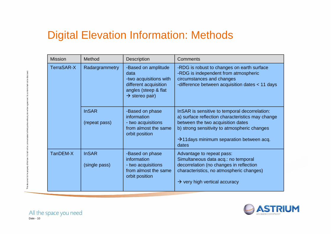
9
Radargrammetry SAR Interferometry
(Stereo 3D reconstruction) (repeat pass InSAR: 11 days)
(single pass InSAR: simultaneous)
Utilization of two images with different acquisition geometry (intensity only) ���� less accurate than InSAR
Utilization of the phase difference of two images with the same geometry� more accurate, where feasible
Digital Elevation Information: Methods
Date - 10
InSAR
(single pass)
Advantage to repeat pass:Simultaneous data acq.: no temporal decorrelation (no changes in reflection characteristics, no atmospheric changes)
� very high vertical accuracy
-Based on phase information- two acquisitions from almost the same orbit position
TanDEM-X
InSAR is sensitive to temporal decorrelation:a) surface reflection characteristics may change between the two acquisition datesb) strong sensitivity to atmospheric changes
�11days minimum separation between acq. dates
-Based on phase information- two acquisitions from almost the same orbit position
InSAR
(repeat pass)
-RDG is robust to changes on earth surface-RDG is independent from atmospheric circumstances and changes -difference between acquisition dates < 11 days
-Based on amplitude data-two acquisitions with different acquisition angles (steep & flat � stereo pair)
RadargrammetryTerraSAR-X
CommentsDescriptionMethodMission
Digital Elevation Information: Methods

Date - 11
InSAR
One area is covered:two times from almost parallel orbit
positions•Repeat pass: TerraSAR-X•(Single pass: TanDEM- Mission)
• Elevation information is derived from the difference distance from one ground point to each satellite position

Date - 12
One area is covered:
• two acquisitions with different acquisition angles (steep & flat � stereo pair)• ~ 20°disparity angle
Radargrammetry
Date - 13
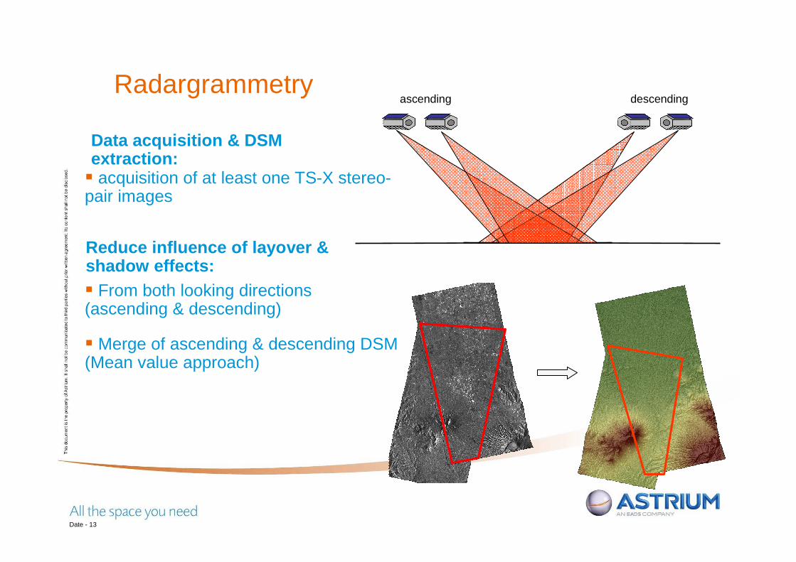
13
Data acquisition & DSM extraction:
ascending descendingRadargrammetry
� acquisition of at least one TS-X stereo-pair images
� From both looking directions (ascending & descending)
� Merge of ascending & descending DSM (Mean value approach)
Reduce influence of layover & shadow effects:

Date - 14
TerraSAR-X:
Radargrammetry-DEM Products

Date - 15
Digital Elevation Models (DEM)
TerraSAR-X Elevation DSM (Radargrammetry):
� Sensor: Independent of weather conditions
� Continuous representation of earth surface
(no data gaps based on clouds)
DSM – Digital Surface ModelDTM – Digital Terrain Model
� Frequency band: X-Band (9,5 GHz)
� DSM (Digital Surface Model): All objects (trees, houses etc.) are included in this model. It represents the surface as we observe it from above (e.g. from an airplane).
Date - 16
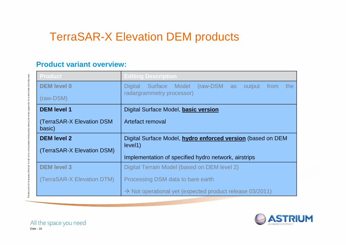
16
Digital Terrain Model (based on DEM level 2)
Processing DSM data to bare earth
� Not operational yet (expected product release 03/2011)
DEM level 3
(TerraSAR-X Elevation DTM)
Digital Surface Model, hydro enforced version (based on DEM level1)
Implementation of specified hydro network, airstrips
DEM level 2
(TerraSAR-X Elevation DSM)
Digital Surface Model, basic version
Artefact removal
DEM level 1
(TerraSAR-X Elevation DSM basic)
Digital Surface Model (raw-DSM as output from the radargrammetry processor)
DEM level 0
(raw-DSM)
Editing Description Product
Product variant overview:
TerraSAR-X Elevation DEM products
Date - 17
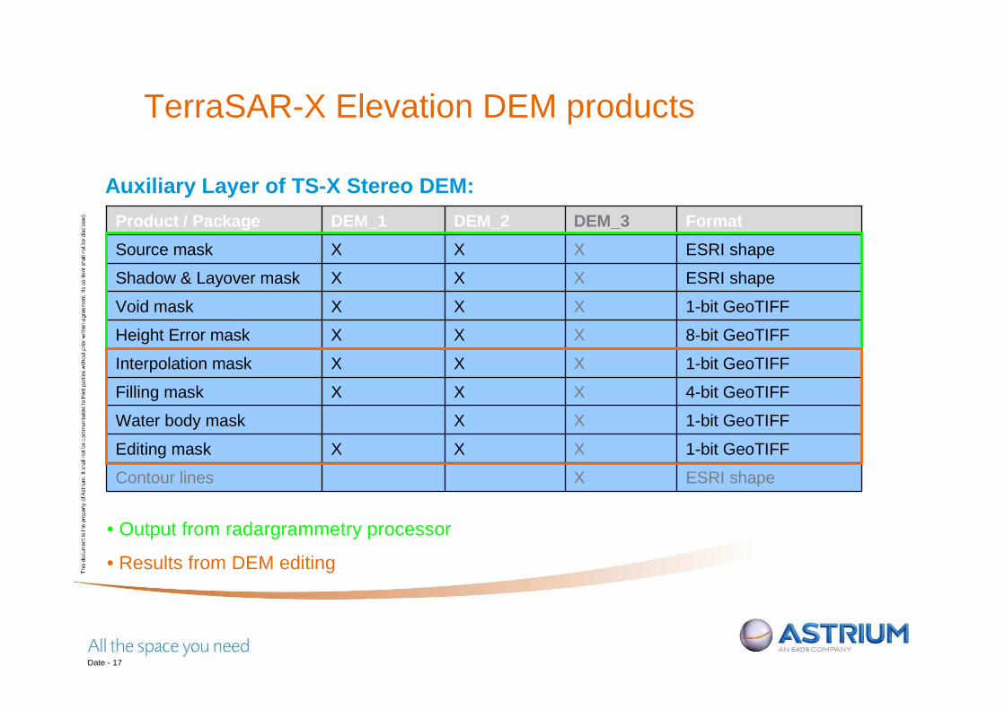
17
Auxiliary Layer of TS-X Stereo DEM:
TerraSAR-X Elevation DEM products
1-bit GeoTIFFXXXEditing mask
ESRI shapeXContour lines
1-bit GeoTIFFXXWater body mask
4-bit GeoTIFFXXXFilling mask
1-bit GeoTIFFXXXInterpolation mask
8-bit GeoTIFFXXXHeight Error mask
1-bit GeoTIFFXXXVoid mask
ESRI shapeXXXShadow & Layover mask
ESRI shapeXXXSource mask
FormatDEM_3DEM_2DEM_1Product / Package
• Output from radargrammetry processor
• Results from DEM editing

Date - 18
TerraSAR-X Elevation DEM products
Date - 19
19
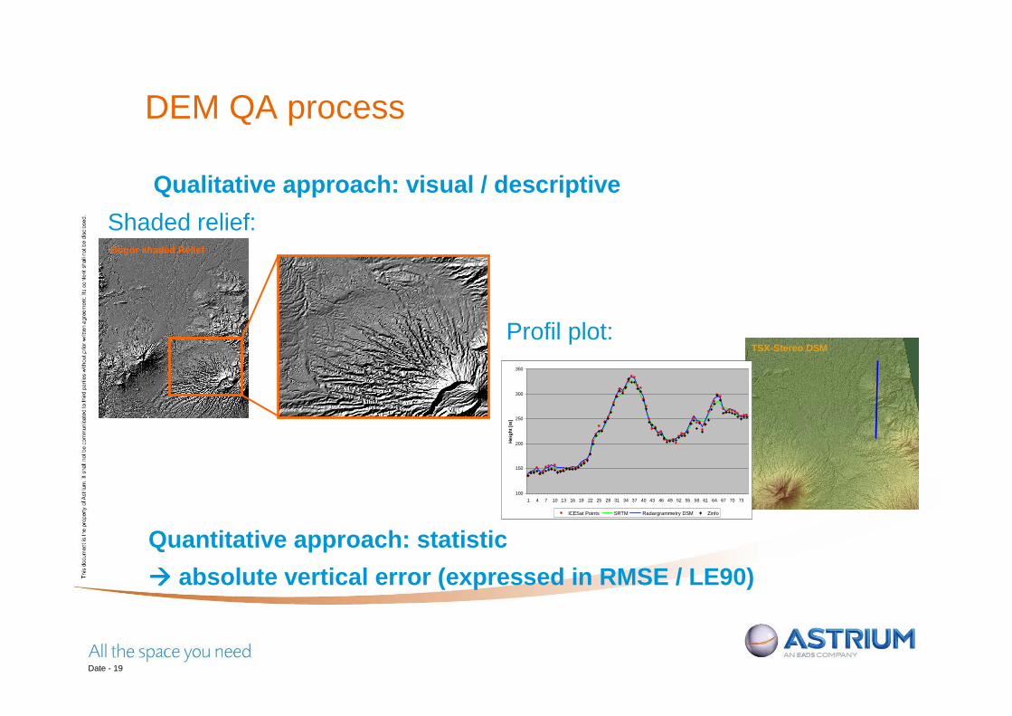
Validation & Verification Approach
Qualitative approach: visual / descriptive
DEM QA process
Bogor shaded Relief
Qua
Shaded relief:
TSX-Stereo DSM
100
150
200
250
300
350
1 4 7 10 13 16 19 22 25 28 31 34 37 40 43 46 49 52 55 58 61 64 67 70 73
Hei
ght [
m]
ICESat Points SRTM Radargrammetry DSM Zinfo
Profil plot:
Quantitative approach: statistic
���� absolute vertical error (expressed in RMSE / LE90)

Date - 20
TerraSAR-X Elevation DSM
Metadata in XML-Format (ISO 19115 compliant ���� Next release)Auxiliary Metadata
UTM projection; UPS projection for polar regions.Horizontal ref. datum WGS84, Vertical ref. datum EG M96
Projection Information
MeterVertical Unit
32-bit GeoTiffData Format
A minimum of 500 km² per orderArea of interest
5 - 10 m (90% circular error) depending on terrainHorizontal accuracy
5 - 10 m (point to point within 100 x 100 km, 90% li near error)Relative vertical accuracy
5 - 10 m (90% linear error) depending on terrainAbsolute vertical accuracy
10 m Grid Spacing
Radargrammetry based on TerraSAR-X StripMap stereo p airsMethod
Product specification:

Date - 21
ISO 19115 xml
Metadata htmlstylesheet
Components of metadata

Date - 22
22
Alpine/Ice/Snow:Wallis (CH)
Mountainous-Flat:Eifel (DE)
Tropical Forest:Kalimantan (IND)
Mediterranean:Marseille (FR)
Tropical Forest:Montserrat
Desert:Oman
Mountainous:Black Forest & Aulendorf (DE)
Mountainous:Solothurn (CH)
Flat:El Manteco (VEN)
Tropical Forest:Malaysia
Reference: high quality DEM (LIDAR, aerial photograph s)
Reference: GPS point samples
Tropical Forest:Sabang (IND)
Alpine / Ice Snow:Juneau (USA)
Dry area:Ft. Irvin (USA)
Urban:Johannesburg (ZA)
Mountainous:Yutan
Verification & Validation Sites
DSM verification & validation
Test sites:
Evaluation based on a variety of test areas and reference data
Date - 23
TanDEM-X: Digital Elevation Models

Date - 24
Nominal Data Acquisition 3 (+?) Years
2010 2011 2012 2013 2014
1 global DEM acquisition with small baselines
1 year1 year
1 global DEM acquisition with larger baselines
1 year1 year
DEM data takes for difficult terrain
with different viewing
geometry
6 months6 months
Customized DEMs
with large interfero-
metric baselines
≥≥ 3 months3 months
Com
missioning P
hase
5 months5 months
Production TDX_IDEM TDX_DEM
2014
DEM Availability TDX_IDEM TDX_DEM
Global DEM: Data Acquisition Plan

Date - 25
� TanDEM-X intermediate DEM�Only one coverage available�Errors and voids expected in mountainous regions�Available also with reduced pixel spacing (factor 2 & 4)
� TanDEM-X DEM - Final DEM Product of the TanDEM-X Mission�Two complete coverages of the earth plus additional acquisitions for difficult terrain �Accuracy according to HRTI-3�Available also with reduced pixel spacing (factor 2 & 4)
� DEMs on special user-request�Accuracy according to HRTI-4, only for local size regions
Global DEM: Product overview
Date - 26
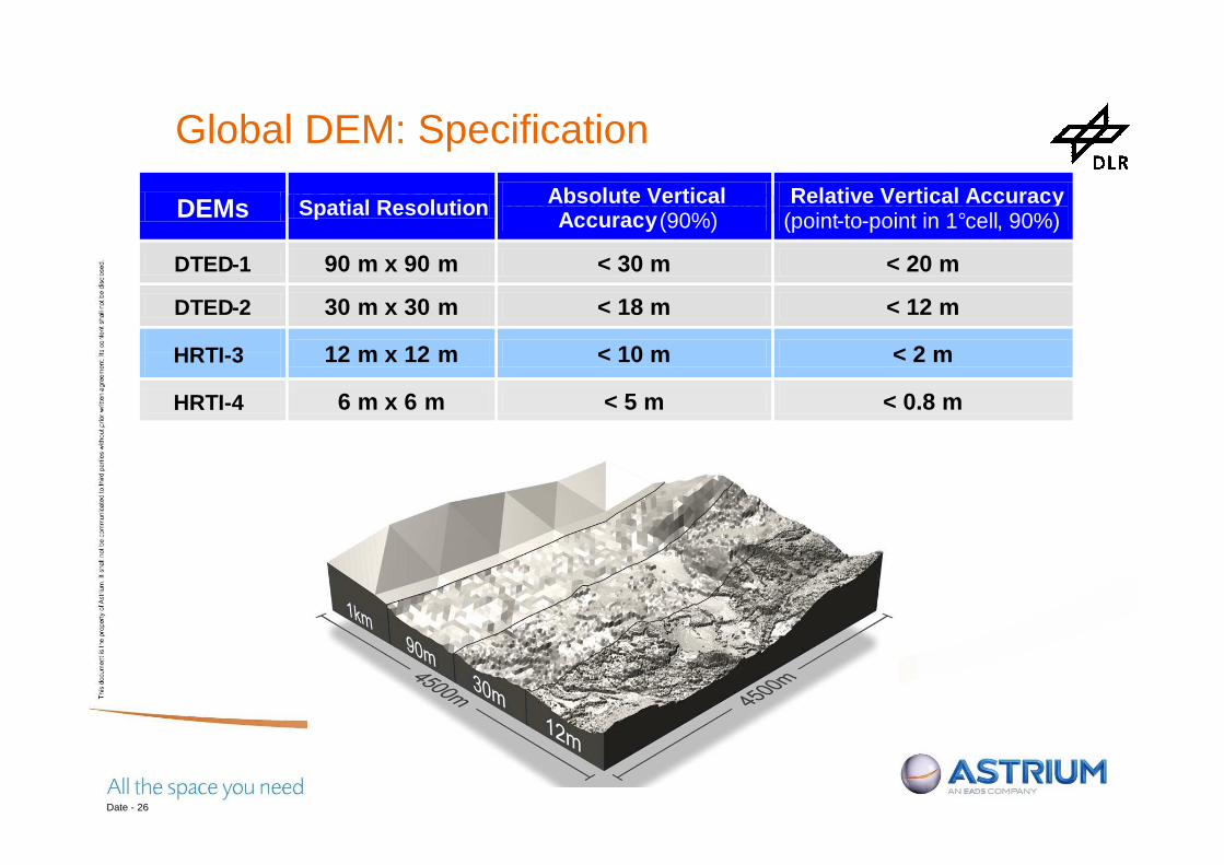
SRTM / X-SAR
� Standards for Digital Elevation Models (DEM)DEMs Spatial Resolution Absolute Vertical Accuracy (90%)
Relative Vertical Accuracy(point-to-point in 1°cell, 90%)
DTED-1 90 m x 90 m < 30 m < 20 m
DTED-2 30 m x 30 m < 18 m < 12 m
12 m x 12 m < 10 m < 2 m
6 m x 6 m < 5 m < 0.8 m
HRTI-3
HRTI-4
Global DEM: Specification

Date - 27
TanDEM-X DEM data
Mount Aetna, Italy

Date - 28
TanDEM-X DEM data
Salar de Uyuni, Bolivia

Date - 29
TerraSAR-X2 – next step in service continuity
� Service continuity, sustainability� TanDEM-X as a bridge� constellation enabled
� New “commercial” business model� Public Private Partnership
TerraSAR-X / TanDEM-X� Commercial mission
TerraSAR-X2
� TerrSAR-X2 mission specifics� Market driven (service definition)� Service Subscription , Partnerships� Coordinated sharing of excess
collect capacities
TerraSAR-X2 will provide service continuity in the family of sustainable, reliable series of high quality SAR satellites
‘08 ‘10 ‘12 ‘14 ‘16 ‘18 ‘20 ‘22 ‘24
TDX PPP
TSX1 PPP
PAZ Hisdesat
TSX2 Infoterra
TSX3 PPP

Date - 30
Vielen Dank für Ihre Aufmerksamkeit
Astrium Services Geo-Information - Infoterra GmbHPlatz der Einheit 14
14467 Potsdam
T: +49 331 237484-03 / F: +49 331 237484-27
Nora Meyer zu Erpen


