
04Chap8_SiteInventory
21
IDENTIFYING OPPORTUNITIES: IDENTIFYING OPPORTUNITIES: IDENTIFYING OPPORTUNITIES: IDENTIFYING OPPORTUNITIES: IDENTIFYING OPPORTUNITIES: SITE INVENTORY AND ANALYSIS SITE INVENTORY AND ANALYSIS SITE INVENTORY AND ANALYSIS SITE INVENTORY AND ANALYSIS SITE INVENTORY AND ANALYSIS 8
-
Upload
syed-husaini-al-jamalullail -
Category
Documents
-
view
243 -
download
0
description
INFO
Transcript of 04Chap8_SiteInventory

IDENTIFYING OPPORTUNITIES:IDENTIFYING OPPORTUNITIES:IDENTIFYING OPPORTUNITIES:IDENTIFYING OPPORTUNITIES:IDENTIFYING OPPORTUNITIES:SITE INVENTORY AND ANALYSISSITE INVENTORY AND ANALYSISSITE INVENTORY AND ANALYSISSITE INVENTORY AND ANALYSISSITE INVENTORY AND ANALYSIS
8

The inventory and analysis of the existing features andconditions of any site is far from an objective process. Rather, itreflects the identification of the site’s critical features andrelationships as determined by the particular perspective definedby both the landscape architect’s theoretical stance and therequirements of the specific project proposed. In other words,the procedures adopted for the inventory and analysis as well astheir results reflect those intangibles a designer brings to the siteas much as they represent the characteristics of the site itself.As such, the inventory and analysis phase marks the first step ingrounding the intangible, non-place-specific aims of the de-signer and the project in physical form. Although the designdevelopment phase (Chapter 9) marks more profoundly themoment when these intangibles merge with the existing site tocreate physical form, the foundation for this transition is estab-lished through a focused inventory and analysis of the site.
The process of inventory and analysis used for theGreenfield site is no exception. Its course was shaped by thetheoretical approaches to design and historical site interpreta-tion discussed in previous chapters as well as by the project-specific issues revealed in the historiographic research. Opera-tionally, this was accomplished by carrying forward the siteselection criteria presented in Chapter 7 as the basic format forthe inventory and analysis process. As discussed in Chapter 7,these site-specific requirements emerged directly out of theConstructivist Design Approach and the historiographic re-search. Employing these site selection criteria as a basic guidefor the exploration of the current site conditions helped ensurethat the inventory and analysis—as the precursor to designdevelopment—carried the theoretical and project-specificpositions into the form-making stage.
Although the site inventory and analysis phase was guided
CONTEMPORARY SITE CONTEXT
Overview
Greenfield Plantation is currently the site of a plannedoffice and business park development called the BotetourtCenter at Greenfield. In the 1990s, Botetourt County acquiredthe 922-acre property, which was then functioning as a cattlefarm, to pursue a state-of-the-art light industrial and businesspark “integrated into anatural landscapedenvironment” (Preser-vation Technologies,1996; Figure 8.1).Although the site islargely undeveloped atthis time, the complexwill ultimately providehigh-tech facilities toas many as 14 busi-nesses while offering
by the site selection criteria, the discussion of the results pre-sented in the remainder of this chapter is organized not strictlyby these criteria but according to the contemporary and histori-cal context of the Greenfield site. Within each of these sections,aspects of the inventory and analysis are then identified asstemming from either the Constructivist Design Approach orthe historiographic research.
Figure 8.1. Main entry to the BotetourtCenter at Greenfield. (Photo courtesy of theOffice of the County Administrator,Botetourt County)
6464646464

the site’s natural envi-ronment as an amenityfor both employees andnearby residents.
Figure 8.2 showsthe current site plan forthe Botetourt Center atGreenfield. Althoughthe site has been subdi-vided into lots, as thesite plan indicates, mostof the site is undevel-oped. Currently, onlyAltec and Koyo havepurchased lots andconstructed buildings.Both of these facilitiesare located south ofInternational Parkway,the east-west arterybuilt by the county asthe main entry into thedevelopment. TheGreenfield Educationand Training Center isalso complete andoccupies the southeast-ern edge of the siteadjacent to U.S. 220. In addition to classroom space, thisfacility offers the latest in computer and heavy manufacturinglabs for training workers at Greenfield as well as communitycollege students.
The portion of the site north of International Parkwayremains undeveloped. The Welcome Center and Historic Areaindicated on the site plan along U.S. 220 is unbuilt. In contrast,the dogleg in the southwest corner of the site is almost fully
6565656565
Figure 8.2. Site plan for the Botetourt Center at Greenfield office and business park development. (Adapted from mapprovided courtesy of the Office of the County Administrator, Botetourt County)

developed, with constructionof the Greenfield ElementarySchool completed and therecreation park in progress.Throughout the site, a systemof conservation areas (dark-est green) with paved walk-ing paths is planned, with thenewly created GreenfieldLake as a focal point.
The areas currentlyundeveloped remain largelyas they did when the propertycame into the county’spossession—predominantlypasture land with forestedpatches and hedgerows(Figure 8.3). Pastures aremaintained through seasonalmowing. Successional forestgrowth has begun along thestream corridors. In addition,the county has demolished allof the structures on the siteassociated with the moderncattle farm. The only structures remaining on the undevelopedportions of the site are those identified in a Preliminary Preser-vation Plan (Preservation Technologies, 1996) commissioned bythe county as having potential historical significance. At thistime, the county plans to relocate some of these structures tothe Welcome Center and Historic Area.
Although Botetourt County intends to develop the entire
Greenfield site, for the purposes of this thesis, only constructioncurrently completed or underway was taken into account. Thismeant that the portion of the site south of International Park-way, including the dogleg in the southwest corner, was immedi-ately eliminated as a potential location for the interpretivecomplex because of the substantial development already occur-ring there. Although acknowledging the existing development in
6666666666
Figure 8.3. Aerial view looking west across the site before development began for the Botetourt Center. The modernfarmstead noted was demolished by the county. International Parkway enters the site off U.S. 220 just to the left ofthe original entrance road labeled in the photo. (Photo courtesy of Kevin R. Shearer, Botetourt County Engineer)

these areas facilitated the site inventory by limiting the studyarea, it also opened the door to an additional set of potentialcomplications, as the visual and auditory impact of this existingdevelopment on visitors at the interpretive complex had to beconsidered in both the site inventory and analysis and in thefinal design proposal.
Constructivist Design Approach Criteria:Dislocation From the External World
The Constructivist Design Approach recognizes theimportance of isolating the interpretive center from potentialintrusions of the modern world in order to facilitate the visitor’simmersion in the interpretive experience. In the site selectionphase (Chapter 7), this concern was addressed through theestablishment of a 100-acre minimum site size, based on thespace requirements of the Follow the North Star program.Although this minimum site size offered a solid first step, theinventory and analysis phase offers the opportunity to conduct asite-specific investigation of potential visual and auditoryintrusions into the site. These viewshed and noise analyses werekey components of the site inventory and analysis. It must bestressed that in these analyses, only those views and sounds notconsistent with the 19th century were considered intrusive. Thismeant, for example, that nearby homes that appeared from theGreenfield site to be consistent with antebellum architecturalstyles were not considered intrusive. Likewise, the sounds ofbarking dogs or people talking were judged compatible with theatmosphere of the interpretive complex. In fact, these elementswere viewed as potentially heightening visitors’ immersion in
the interpretive experience, as such sights and sounds couldintensify their fear of discovery and sense of vulnerability asthey assumed the role of runaway slaves (see Chapter 9 for adiscussion of surveillance and visibility in the outdoor tours).
Viewshed Analysis. The objective of the viewshed analysiswas to identify areas of the site that allowed unwanted views tomodern structures. Such potentially distracting views weredivided into two categories: uncorrectable views that could notbe blocked or screened through the installation of vegetation orstructures on the interpretive grounds, and correctable viewsthat could be blocked with well-placed plantings or structureson the interpretive complex property. Although some of theviews classified as uncorrectable in the viewshed analysis couldindeed have been mitigated by screening efforts immediately infront of the modern structures, for the purposes of this thesis,only interventions that could be installed on the interpretivegrounds were considered. In reality, however, this latter optionshould be pursued to the extent that landowners are amenable.
The viewshed analysis began with a landform analysisusing a USGS topographic map. Since the area south of Inter-national Parkway had been previously eliminated as a potentialsite for the interpretive complex because of heavy development,the analysis focused on identifying areas in the remainder of thesite that, based on landforms, would allow unwanted views.This preliminary analysis on paper was followed up with fieldvisits to refine the limits of the usable site. Field visits wereconducted in January and February, when views off the sitewere not screened by vegetation. Such a “worst-case scenario”established a valuable baseline, since the interpretive center isintended to remain open virtually year-round.
Figure 8.4 shows the results of the viewshed analysis. As
6767676767

Figure 8.4. Results of viewshed analysis. The majority of the undesirable views (dark and light purple areas) came from modern structures within orimmediately adjacent to the Greenfield site. The most visible structures included the Koyo complex, the Greenfield Education and Training Center, and thewater tower located in a northern corner of the site (also the highest elevation on the site). Views of International Parkway and Route 220 were limited toareas immediately adjacent to the roads. The unshaded area south of International Parkway, previously eliminated as a potential site because of existing
development there, was not included in the analysis.
6868686868

the figure indicates,views throughoutthe western portionof the site were tooseverely degraded(dark purple shad-ing) to make anyon-site remediationfeasible. With thearea of the sitesouth of Interna-tional Parkway
already ruled out as a potential site for the interpretive complex,this left only the northeastern quadrant of the site. As theviewshed analysis shows, however, portions of this area stillallowed intrusive views. Those areas where such views couldnot be mitigated on site (dark purple) began to define the limitsof the outdoor interpretive area, whereas most of the intrusiveviews within the areawere considered correct-able (light purple).Options for treatingthese correctable viewsincluded enhancingexisting hedgerows withevergreen plantings(Figure 8.5) or plantingnew hedgerows orforested areas on or nearthe crests of hills (Figure8.6). It is important tonote, however, that
Figure 8.5. This view of the Koyo complexcan be screened by enhancing the existinghedgerow remnant with evergreen plantings.
decisions about whether to employ these strategies were madewithin the context of designing a coherent landscape reflectiveof 19th century Appalachia. In other words, a hedgerow used forscreening purposes also had to serve its intended functionwithin the agricultural landscape. As stated earlier, the darkpurple region that bordered the usable area of the site becamethe borders of the interpretive grounds. Rather than attemptingto screen these views, it was determined that a more workablesolution was to prevent visitors from accessing these areas (seeChapter 9 for further explanation).
Noise Analysis. Visual reminders of the modern world arenot the only factor that can undermine a designer’s attempt toisolate a site from the 21st century. The sounds of the modernworld can also intrude upon a site and distract visitors from theinterpretive experience. Although some noise pollution, such asairplanes, is beyond a designer’s control, the traffic noisepresent on some parts of the Greenfield site was identified as apotential distraction that needed to be avoided or mitigated bydistracting visitors’ attention from it.
A traffic noise analysis was conducted on site to identifyareas of the site impacted by road noise. As the results of theanalysis (Figure 8.7) show, the portion of the site immediatelyadjacent to U.S. 220 was most affected by road noise. Trafficnoise along International Parkway was also a factor, althoughcar traffic was intermittent and sound levels were much loweroverall than on U.S. 220. The darker pink areas in Figure 8.7indicate regions in which the traffic noise was too loud to maskor otherwise mitigate. Such areas needed to be avoided andthus, as with the viewshed analysis, the areas of the site with thedarkest shading began to define the limits of the interpretivegrounds. For the areas in which traffic noise was less intru-
Figure 8.6. Installation of a new forestpatch or hedgerow along the ridgelinewould screen this view of the Koyocomplex.
6969696969

Figure 8.7. Results of the traffic noise anlaysis. The majority of road noise comes from U.S. 220. Traffic on International Parkway is relatively light andoccurs predominantly in the early morning and evening, as well as during lunch time.
7070707070

sive—a low, steady drone of white noise (the lighter pinkregions)—a general strategy of distraction was adopted. Giventhat most modern Americans are so accustomed to the fainthum of traffic that they usually fail to consciously note itspresence, it was determined that the most effective mitigationstrategy would be to prevent the traffic hum from enteringvisitors’ consciousness by keeping their attention focused onthe interpretive experience. In other words, as long as theinterpretive programming in these lighter pink regions providedenough dramatic intensity, visitors would not have an opportu-nity to notice the traffic noise. For example, costumed interpret-ers could be stationed in these areas to either directly engagevisitors in an exchange or simply to provide a focal point fortheir attention.
Revised Site Boundary. The regions identified in both theviewshed and traffic noise analyses as impacted by the modernworld beyond the ability of mitigation efforts to redress (darkershades) began to define a boundary for the interpretive center—not in terms of an absolute property limit but in terms of thearea suitable for the interpretive program. The shaded region inFigure 8.8 indicates the area of the site suitable for interpretiveprogramming. This working boundary is derived from both theviewshed and traffic noise analyses as well as from the desire toavoid extending the interpretive area up to the absolute bound-ary of the Greenfield property. Providing a land buffer aroundthe interpretive area will help ensure that the encroachment ofthe modern world into the interpretive grounds can be kept to aminimum. Although the actual area taken up by interpretiveprogramming is relatively small, ideally, the rest of theGreenfield site north of International Parkway would be ownedby the interpretive complex in order to help maintain this buffer.
Historiographic Research Criteria: LandscapeCharacteristics and Features
The historiographic research revealed a number of land-scape characteristics and features whose presence on the sitecould enhance the interpretive program. These characteristicsand features made up part of the site selection criteria discussedin Chapter 7. Each of these features, discussed individuallybelow, is shown in Figure 8.9, the existing conditions plan.
Figure 8.8. The shaded area indicates the area suitable for theinterpretive program based on the desire to isolate the interpretivecomplex from the external world.
7171717171

Figure 8.9. Existing conditions plan for the Greenfield site. Overlain on this plan is a brown line indicating the limits of the interpretive area as shown inFigure 8.8 and determined through the viewshed and traffic noise analyses.
7272727272
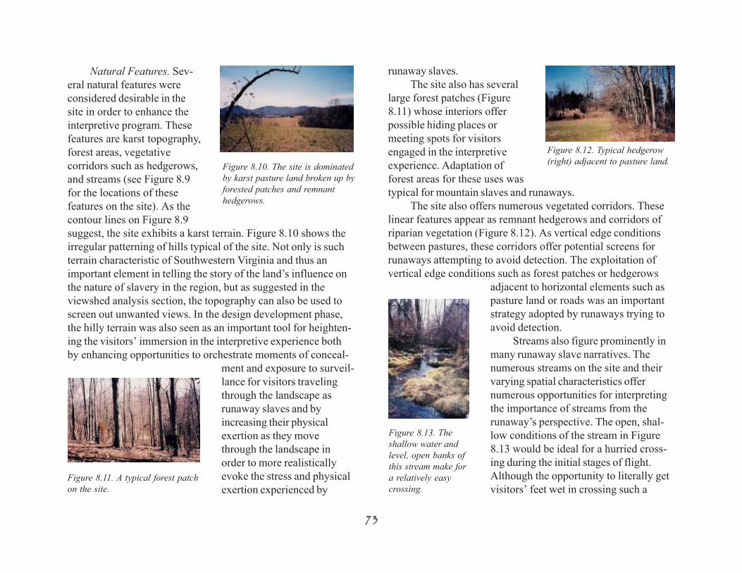
Natural Features. Sev-eral natural features wereconsidered desirable in thesite in order to enhance theinterpretive program. Thesefeatures are karst topography,forest areas, vegetativecorridors such as hedgerows,and streams (see Figure 8.9for the locations of thesefeatures on the site). As thecontour lines on Figure 8.9suggest, the site exhibits a karst terrain. Figure 8.10 shows theirregular patterning of hills typical of the site. Not only is suchterrain characteristic of Southwestern Virginia and thus animportant element in telling the story of the land’s influence onthe nature of slavery in the region, but as suggested in theviewshed analysis section, the topography can also be used toscreen out unwanted views. In the design development phase,the hilly terrain was also seen as an important tool for heighten-ing the visitors’ immersion in the interpretive experience bothby enhancing opportunities to orchestrate moments of conceal-
ment and exposure to surveil-lance for visitors travelingthrough the landscape asrunaway slaves and byincreasing their physicalexertion as they movethrough the landscape inorder to more realisticallyevoke the stress and physicalexertion experienced by
Figure 8.12. Typical hedgerow(right) adjacent to pasture land.
runaway slaves.The site also has several
large forest patches (Figure8.11) whose interiors offerpossible hiding places ormeeting spots for visitorsengaged in the interpretiveexperience. Adaptation offorest areas for these uses wastypical for mountain slaves and runaways.
The site also offers numerous vegetated corridors. Theselinear features appear as remnant hedgerows and corridors ofriparian vegetation (Figure 8.12). As vertical edge conditionsbetween pastures, these corridors offer potential screens forrunaways attempting to avoid detection. The exploitation ofvertical edge conditions such as forest patches or hedgerows
adjacent to horizontal elements such aspasture land or roads was an importantstrategy adopted by runaways trying toavoid detection.
Streams also figure prominently inmany runaway slave narratives. Thenumerous streams on the site and theirvarying spatial characteristics offernumerous opportunities for interpretingthe importance of streams from therunaway’s perspective. The open, shal-low conditions of the stream in Figure8.13 would be ideal for a hurried cross-ing during the initial stages of flight.Although the opportunity to literally getvisitors’ feet wet in crossing such a
Figure 8.11. A typical forest patchon the site.
Figure 8.10. The site is dominatedby karst pasture land broken up byforested patches and remnanthedgerows.
Figure 8.13. Theshallow water andlevel, open banks ofthis stream make fora relatively easycrossing.
7373737373

shallow stream is considered a desirabledesign element because of theConstructivist Design Approach’s em-phasis on sensory engagement in theinterpretive experience, the crossingcould be made safer with the placementof a “fallen” tree across the stream as ahandrail or a few additional steppingstones in the streambed. In contrast tosuch a relatively easy crossing, otherstreams on the site offer greater chal-lenges. Figure 8.14 shows the steep pathworn by deer down to a stream. Tocross this deeply incised stream, visitorswould have to search along the banks for
a manageable crossing place. Such a stream also offers theopportunity for a bridge crossing. Historiographic researchrevealed that bridges were often manned by toll collectors andthus were avoided by runaways, who had to find their own wayacross a stream.
Man-Made Features. Evidence of man’s interventions onthe land was also seen as a potentially important aspect of thesite in terms of the interpretive program. Remnants of the smallfarmsteads and wagon roads that dotted the nineteenth centurylandscape of the Mountain South were identified in Chapter 7as important features. The Greenfield site offered some remark-able examples of each of these man-made features.
Evidence written on the land of the placement, function, orappearance of the small farmsteads typical of the MountainSouth as well as the larger, more affluent “plantations” wasviewed as a way of ensuring that the proposed designed land-
Figure 8.14. Deeplyincised stream bank(photo taken fromthe stream itself).
scape of the interpre-tive complex re-mained faithful (tothe extent possible ina designed land-scape) to the spirit ofsettlement and landuse practices in the19th century Appala-chian South. TheGreenfield siteoffered two suchantebellum settle-ment complexes—the Greenfield homestead and the Dowerhomestead (see the next section of this chapter for the historicalsignificance of these complexes). Both homesteads were rela-tively affluent farmsteads for Appalachian Virginia. Each in-cluded not only the big house but also its outbuildings, includ-ing kitchen and slave quarters, and family cemeteries. Although
the foundations ofall the structuresare still visible,only the Greenfieldkitchen and slavequarters (Figure8.15) and theDower kitchen,which also likelyhoused slaves(Figure 8.16), stillstand. The rem-nants of a bank
Figure 8.15. The Greenfield slave quartersremain intact, although in need of repair. Acinderblock addition (far right) is visible.
Figure 8.16. The original log structure of theDower kitchen is hidden by later additions. Itruns from the far left addition to the brickchimney behind the clump of three trees.
7474747474

barn are also visible in theDower complex (Figure8.17). All of these struc-tures are in need of exten-sive restoration and re-pairs.
Road traces were alsoseen as a valuable asset onthe site. They suggest howroads responded to theterrain and features of thelandscape before theadvent of mechanized
earth-moving equipment. Incorporating these traces into thedesign of the interpretive complex would help ensure thecreation of a realistic 19th century Appalachian landscape.
In addition, roads figured prominently in the story ofAppalachian slavery as both the route into and out of bondage.Historiographic research revealed that the stage roads of the eraprovided important infrastructure for the mountain slaveeconomy. Not only did the Great Valley Road facilitate theexport of mountain slaves to the slave markets of the DeepSouth where the demand for labor was higher, but the turnpikesalso fueled the local slave economy as itinerant slave traderswent door-to-door buying and selling slaves. Such slave coffles(chained gangs of slaves led by slave traders and usually travel-ing on foot) were a common sight along the Great Valley Roadand its byways in the Mountain South. But even as the roadscarried such slaves into bondage, other slaves appropriatedthem on their journey to freedom. Runaways trying to maketheir way north often followed roads from the cover of adjacentforests. Northbound roads offered a more reliable navigational
guide than the North Star, which was often obscured by clouds.Following roads had the added benefit of keeping slaves closeto towns and cities, where they could more easily find food orassistance than in the wilderness. It also, of course, increasedtheir risk of discovery, but most slaves were willing to toleratethis risk for the potential benefits.
Site visits revealed the presence of four road traces on theproperty (see Figure 8.9). Although their ages cannot be deter-mined, they are all unpaved and thus offer insights into histori-cal folk road placement practices. One of these road tracesmarks an older entry into the Dower homestead and theGreenfield plantation from U.S. 220 (shown in Figure 8.3). Theremaining three road traces are associated with three streamfords on the property (the stream crossing in the northeastquadrant of the property was originally a bridge). Althoughthese old roads are only partially discernible, as the existingconditions plan (Figure 8.9) suggests, the roads traces at onetime may have joined to form a circuit around the property. Oneroad trace cuts across open pasture (northeast corner of thesite), while the othertwo are located in whatare now forested areas(Figure 8.18). Theselast two road tracesoffer a landscapecondition often ex-ploited by runawayslaves—following aroad as a navigationalaid from the relativesafety of an adjacentwooded area.
7575757575
Figure 8.17. Stone foundations ofthe German bank barn set into thehillside behind it.
Figure 8.18. Road trace through aforested pocket on the Greenfield site.

HISTORICAL SITE CONTEXT
Constructivist Design Approach Criteria:Structured but Flexible Meaning
For the constructivist designer, incorporation of the historyof the Greenfield site itself into the interpretive complex offersan opportunity to increase the possibility that visitors willconstruct meaningful experiences there. The ConstructivistDesign Approach is based on the premise that meaning isconstructed out of the collaboration between the individual andthe site. As in any collaborative process, success depends uponthe raw materials that each party brings to the partnership andhow these materials resonate with each other. For the indi-vidual, this raw material consists of a unique set of experiences,attitudes, and knowledge that mediates his or her interactionwith the site. The raw materials of the site consist of its formaland programmatic elements. In other words, the site functionsas a stockpile of building blocks out of which visitors constructmeaning.
This view of a designed site suggests that the landscapearchitect’s work is merely the beginning of the design process,not the end of it. Rather than providing a client with a landscapethat has reached the end of its design evolution, the designermust set his or her priority on enriching the collaborativeprocess by providing the raw material at the site. Incorporatingelements of the history of Greenfield Plantation into the inter-pretive complex, both in terms of physical form and program,would add such richness to the site—another layer at whichvisitors could potentially engage with and interpret the site. In
this way, the richness or depth of a designed site imbues it withthe flexibility necessary to allow for multiple, individualizedinterpretations. Just as the richness of language and thought in aclassic piece of literature supports multiple understandings ofthe text, the constructivist site uses its richness and multilayeredquality to encourage a multitude of interpretations.
Although a rich supply of raw materials offered by thedesigned site can encourage the collaborative process betweenvisitor and site, too much disparate content can be counterpro-ductive to the meaning-making process. Fruitful richness candegenerate into chaos without an overall structure—an inter-pretive framework—that not only helps the landscape architectmake appropriate design decisions but also gives visitors acognitive framework through which to interpret the site. Interms of the interpretive complex, this structure or frameworkemerged from the interpretive content established by the histo-riographic research. Thus, decisions about which elements ofGreenfield’s history should be incorporated into the interpretivecomplex were guided by the opportunity they provided toenhance or support the interpretation of the content establishedby the historiographic research.
The rest of this chapter is devoted to a summary discussionof the elements of Greenfield’s history that have the potential, inlight of the historiographic research on Appalachian slavery, toadd depth to the interpretive agenda of the complex and thusenhance its meaning-making capacity.
Unless otherwise indicated, the historical informationabout Greenfield Plantation and its owners presented in thissection comes from the Historic Background written by MariJulienne for the National Register of Historic Places Nomina-tion for the Bowyer/Holladay House (Preservation Technolo-gies, 1998).
7676767676

Early Years of Greenfield. In many ways, the history ofGreenfield Plantation and its owners—the Preston family—isthe history of the development of Southwestern Virginia. In the200 years that Greenfield remained in the Preston family (1759-1960), the landscape of Southwestern Virginia changed dra-matically. Those changes are reflected in the history of theGreenfield property, as it evolved from a log cabin outpost onthe Western frontier of European expansion, to one of the mostaffluent antebellum plantations in the county, to a modestcontemporary farm. Slavery—both in terms of its presence andits absence after the Civil War—had a strong hand in shapingthe landscape of Greenfield and the region.
In 1759, William Preston, a 30-year-old Irish immigrant,purchased 191 acres of land near Tinker Creek in SouthwesternVirginia with the intention of settling his young family there.This land, soon to be named Greenfield, lay along the cusp ofEuropean expansion into Indian territory. William, along with18 newly purchased slaves (Troutman, 2002), set about the taskof building a new home for his wife Susanna and their youngdaughter. In these early days, however, the Shawnee Indiansalso claimed the region as part of their hunting grounds, andWilliam’s family, along with a handful of other determinedsettlers, spent much of their time within the protective walls ofa fort somewhere near the Greenfield site. Despite this precari-ous beginning, however, the Greenfield homestead served acritical function as an outpost in Indian territory that helped setthe stage for further European settlement of SouthwesternVirginia (Johnson, 1976).
As the threat of Indian attacks faded and the RevolutionaryWar ended, an increasing number of Europeans came to theregion and settled down to the business of building their for-tunes and building America. By this time, William (now a
colonel) hadattained militarydistinction forhis participationin the Revolu-tionary War aswell as earliertreaty negotia-tions with theIndians, helpedGeorge Wash-ington surveythe Virginiafrontier, andserved as a county justice, sheriff, coroner, and escheator, aswell as a Representative to the Virginia Assembly (Dorman,1982). The Prestons prospered and Greenfield expanded. By1783 (the year of William Preston’s death), the plantation hadgrown to 2,175 acres and enjoyed a reputation as one of themore affluent farmsteads of Southwestern Virginia, as theglazed windows (a luxury in the region) on the Greenfield bighouse attested (Figure 8.19; Johnson, 1976).
The Second Generation at Greenfield. By the first half ofthe 1800s (the time period addressed in the interpretive com-plex), Greenfield had been divided among Colonel Preston’sfour children. John Preston, the eldest son, received the westernsection of the property, including the area identified in theexisting conditions map (Figure 8.9) as the Greenfield Home-stead. This included the Greenfield big house and its attendantslave quarters and kitchen building. John’s two sisters, Sarahand Susan, owned what was referred to as East Greenfield. This
Figure 8.19. The Greenfield big house not longbefore it was destroyed by fire in 1959. (Johnson,1976)
7777777777

portion of the property included what is labeled as the DowerHomestead in Figure 8.9.
During the majority of this time, John was an absenteeowner, choosing instead to live about 40 miles away at Horse-shoe Bottom (another plantation left to him by his father). Johnrelied primarily on overseers or tenant farmers to managed thefarm and the slaves who lived there. Despite this arrangement,correspondence also indicates that he and his family madefrequent trips there, and from at least 1822 to 1825, theyconsidered Greenfield their primary residence.
John’s sister Sarah apparently spent all of her adult life atGreenfield. Upon marrying her husband Henry Bowyer in 1830,the couple moved into the Dower house (which apparentlyreceived its name because it was built as a wedding present tothe couple; Figure 8.20). Over the next 20 years, the coupleincreased the size of their East Greenfield property from 300
acres to 500 (some of it from Sarah’s sister Susan), accordingto the 1850 Census.
The Antebellum Landscape of Greenfield. The area ofBotetourt County in which Greenfield is located has long beenrecognized as one of the more fertile regions of SouthwesternVirginia. Even before Colonel William Preston came to the areain the mid-1750s, much of the land had been cleared by theIndians for farming. The 1800s were no exception. By this time,both John Preston and Henry Bowyer identified their primaryoccupation as farmers in Census records. John was plantinghemp, wheat, corn, rye, hay, oats, barley, flax, and potatoes andraising cattle, hogs, and a few sheep.
On East Greenfield, 1850 Census records indicate thatHenry produced Indian corn, wheat, oats, hay, clover seed, andIrish potatoes. He also had nine horses, three mules, six milchcows, 34 other cattle, 100 hogs, and 40 sheep. In the 1840s,corn was the most widely grown crop in Botetourt County.Like the other farmers of Southwestern Virginia, the majority ofthe goods produced at Greenfield were consumed on thepremises (by people and livestock) rather than being sold forprofit. The region was also know for its fruit orchards, and by1880, Henry was harvesting crops from a 4-acre apple orchardon his section of Greenfield.
The Landscape of Slavery at Greenfield. Although Johnand Henry farmed in a manner similar to their neighbors, theydid so at a much grander scale. This meant that the availabilityof slave labor was crucial. Whereas most mountain farmers,producing little more than subsistence crops, held only one ortwo slaves, Henry and John were among only a few planters inthe county that owned more than 20 slaves. In 1817, John was
7878787878
Figure 8.20. The Dower big house in 1947. The kitchen/slave quarters areto the left of the main house. The main house was torn down in the mid-1900s. (Virginia Department of Historic Resources, Roanoke)
taxed for 55 slaves over the age of twelve at Greenfield. By1830, Henry owned 23 slaves—roughly split evenly betweenmale and female. Eleven were under the age of ten. This sug-gests a heavy presence of family units among the slaves at theDower farmstead. While the Bowyer’s slave holdings wouldremain relatively steady in terms of numbers up to the CivilWar, slave schedules suggest that the presence of intact familyunits sharply declined. By 1860, only four of the Bowyer’s 21slaves were females. Although the reason for this drop in thepresence of adult female slaves is unknown, it suggests a transi-tion from a relatively stable slave population in which familyunits were allowed to stay intact to one in which the selling andbuying of individual slaves occurred more frequently. Such atransition would not be surprising for a mountain master, whoseprofits typically came not from a slave’s value as an agriculturallaborer but as a commodity that could be bought, sold, orleased to take advantage of market forces (Dunaway, 1999).
To date, little information has been documented regardingthe daily activities of slaves at Greenfield (Troutman, 2002).Certainly, they would have preformed the vast majority of thefarming and livestock work. In addition, they would have builtmost of the structures on the site, including the eight slavequarters that an 1860 Census taker recorded at Greenfield.Correspondence also indicates that one of John Preston’sslaves, Godfrey Brooks, was responsible for managing theplantation in his master’s absence from 1809 to 1811. In lettersapparently written by Brooks himself, he describes theGreenfield slaves engaging in such tasks as making nails torepair the fences, sowing wheat and rye, harvesting corn,threshing the hemp, and tending to the cattle, hogs, and horses.
Not all of the slaves residing at Greenfield were as reliableas Brooks, however. An April 1812 letter from John’s brother
Thomas at Greenfield reported that two of his slaves, Danieland Emanuel, ran away after they were severely whipped. Therecords do not indicate whether the two were found, returnedon their own, or were never seen again. The results of thecontent analysis of runaway slave narratives (Appendix B)indicate that a severe or unwarranted punishment often moti-vated slaves to run away. Whereas many such slaves returned ina few days, those whose masters consistently mistreated themtypically never returned unless caught.
By the first half of the 1800s, the Preston family ownedfive plantations in Southwestern Virginia (Greenfield,Smithfield, Solitude, Whitethorn, and Horseshoe Bottom) andanywhere from 40 to 90 slaves at any given time. Evidencesuggest that the family’s resources—including their slaveholdings—were often shifted between properties as workrequirements changed. A handful of family slaves, for example,were even sent to the Colonel’s son Francis (John’s brother)whose wife owned salt works in Saltville, Virginia (Troutman,2002). This mobility was a typical characteristic of slavery inthe Mountain South, where masters had to engage in a varietyof businesses to make a profit rather than relying solely onagriculture. Slaves were often sold or leased, or even shiftedbetween a master’s enterprises, according to where they couldbe most profitable (Dunaway, 1999). The Prestons’ large slaveholdings would have been an important family resource.
In addition to their temporary or permanent reassignments,the Prestons’ slaves also endured a series of traumatic upheav-als and relocations that were also typical of all slaves. Theseoccurred when owners died and the slaves were either soldaway or divided among heirs. Slaves especially feared the deathof a master, for the relocation process almost always meant theseparation of family units (Dunaway, 1999). The Preston slaves
7979797979

experienced four such upheavals (Troutman,2002), including the death of Colonel WilliamPreston’s wife Susanna in 1823. Although noinformation is currently available on the fate ofthe family slaves after her death, the runawayslave content analysis as well as Dunaway’s(1999) research revealed that the immanent saleand consequent dissolution of the family thatcame with the death of a master was the biggestfactor in slaves’ decisions to run away.
The Great Valley Road. Along the easternedge of the Greenfield property ran the GreatValley Road. Just as the Prestons’ home atGreenfield had evolved from a one-room loghouse to a grand plantation home in the yearsbefore the Civil War, the Great Road too hadevolved from a narrow footpath used by NativeAmericans to a macadamized interstate road—the major route for settlers and trade goodsthrough the mountain region. Indeed, much ofthe Preston’s early prosperity could likely beattributed to Greenfield’s favorable location at acrossroads along the Great Road.
Although the exact locations of the earlyroads are lost, the Great Valley Road ran alongthe eastern edge of the Preston’s property(Johnson, 1976). Modern-day U.S. 220 be-tween Fincastle and Roanoke is believed toapproximate its route (see Figure 8.21). To-ward the southern end of the Greenfield prop-erty, a branch of the Great Road diverged west
8080808080
Figure 8.21. Although 19th century Greenfield and the neighboring town of Amsterdam werefarming areas, they were surrounded by iron mining and processing operations. At thecrossroads of the Great Valley Road and the Carolina Road, much of Greenfield’s success couldbe attributed to its favorable location.

Figure 8.22. Sketch of slave coffle heading down the Great Valley Roadsouth of Staunton. (Abby Aldrich Rockefeller Folk Art Museum, ColonialWilliamsburg Foundation, Williamsburg, VA)
ings, it is highly likely that traders would have made the promi-nent Greenfield plantation a consistent stop on their journeysouth. The sight of these itinerant slave traders was common inthe mountain region. They dragged behind them what werereferred to as slave coffles (Figure 8.22)—bedraggled groups ofslaves usually chained together to prevent them from escapingand traveling on foot. In some cases, women and children wereallowed to ride in the supply wagons. Troutman (2002) calcu-lates that 80 to as many as 200 slaves passed through South-western Virginia along the Great Road each week (see Appen-dix C for more details).
The Iron Industry. Like the Great Valley Road, the preva-lence of the iron industry also had a dramatic effect on both the
8181818181
and wound through the Catawba Valley toward Blacksburg(where the Preston’s other plantations were located), while theCarolina Road continued south from there through Big Lick(Roanoke).
Although the area was only lightly populated when WilliamPreston established Greenfield, the roads would soon bringcivilization to the plantation’s doorstep—additional settlers tohold back the Shawnee, much needed provisions to supplythem, and even an opportunity for profit. As early as the 1770s,William had set up stills and obtained a peddlers license to sellwhisky to thirsty travelers passing by Greenfield (Johnson,1976). By 1794, the prime location had drawn enough settlersto found the modest town of Amsterdam just south ofGreenfield on the Great Road. By this time, traffic in the areawas great enough to support not only William’s business ven-ture but also ordinaries opened by several Amsterdam residents(Prillaman, 1985).
From these early days, the Prestons relied on the supply ofgoods afforded by the Great Road. Barrels of sugar, fabrics, andbooks for his children’s education were just a few of the itemsthat made their way to William Preston and his descendantsdown the Great Road. One of the most important commoditiestransported down this turnpike, however, was slaves. As moun-tain masters found they could profit more from selling theirslaves to the Deep South than by putting them to work at home,the Great Road became the primary conduit to the great slavemarkets of the Deep South. Dunaway (1999) estimates thatalmost one million slaves were transported from the Upper tothe Lower South between 1790 and 1860. Independent slavetraders made their way down the Great Road, buying andselling slaves with residents along the way. Although thePreston family papers have not brought to light any such deal-

nature of slavery in Southwestern Virginiaand the appearance of the landscape itself(see Appendix C for more details). AlthoughGreenfield and Amsterdam were primarilyagricultural, the surrounding mountains werelittered with iron mining and processingoperations (Figure 8.21). This mixture ofagricultural and industrial activities wascommon throughout the Appalachian Vir-ginia landscape of the 1800s as mining andprocessing operations harvested the vastquantities of ore the mountains offered whilefarmers worked the deeper soils of the valleybottoms. By the 1830s and 1840s, more than75 iron furnaces were in blast in the BlueRidge and Shenandoah Valley (Figure 8.23),with a great deal of this activity in Botetourtand the surrounding counties (Russ,McDaniel, & Wood, 2000). Although someof the iron was refined in the region (mostlyas tools for local farmers and artisans), most was exportedthrough Lynchburg to the Tredager Iron Works in Richmond.The importance of the region’s iron production to the Southextended through the Civil War, when the Confederacy de-pended on iron shipments from Botetourt and Rockbridgecounties, as well as adjacent Alleghany, Craig, and Bath coun-ties for the manufacture of armaments (Russ et al., 2000). (SeeAppendix C for more details.)
These furnaces, and the supporting activities they required,left a distinct mark on the land. In addition to the mines duginto the mountain sides and the furnaces with their large stonestacks belching smoke, the iron operations diverted streams to
8282828282
supply water to the furnaces, quarried limestone for use in thesmelting process, cut roads through the mountains to connectthe various parts of their operations, and left behind vast slagpiles (the lava-like residue of the smelting process) and smol-dering charcoal pits used to convert wood into the charcoalneeded to heat the furnaces. More than the smoke, heat, andnoise produced in these operations, however, the dramaticdeforestation that accompanied iron processing probably hadthe largest visible effect on the mountain landscape. Producingenough charcoal to fuel an iron furnace for a single day requiredabout 1 acre of timber. On average, furnaces consumed 250-300 acres of hardwood forest per year (Russ et al., 2000). Most
Figure 8.23. Iron furnaces and their attendant mining operations made a major impact on thelandscape of Appalachian Virginia. Greenfield was located on the southern edge of one of themost important ore-producing regions in the state. (Data taken from Kuennecke et al., 1989)

likely, the 19th century view from Greenfield to the surroundingmountains would have revealed the prominence of industry inthe region rather than an unspoiled sylvan wilderness.
In addition to the changes to the landscape itself, the ironindustry also helped shape the characteristics of slavery inAppalachia. In addition to the coffles headed to the DeepSouth, the Great Road would likely have brought leased slavesheading to and from their yearlong assignments at the furnacespast Greenfield. The iron furnaces that proliferated the moun-tains of Virginia depended on slave labor to work around theclock and keep production rates high, and the practice ofleasing slaves to this local industry for 12-month terms becamecommon in the Appalachian South. Not only did this practicebenefit the iron manufacturers who often faced labor shortagesbut it also allowed mountain masters to earn a profit on slavesthey could not put to work on their own farms. Although for
the slaves, this often meant separation from their families andexposure to dangerous work in the mines and furnaces, thewidespread system of paying slaves directly for their frequentovertime work did allow some slaves to improve their own andtheir families’ daily living conditions by supplementing theirfood and clothing allowances and in rare cases to eventually buytheir freedom.
As the preceding discussion suggests, the unique history ofthe site offers numerous opportunities to carry forward impor-tant interpretive elements revealed in the historiographic re-search into the design phase. The site’s history suggests avehicle through which those interpretive elements can be woveninto the interpretation rather than forced.
8383838383


