01 Soils lanner - USDA
28
in the Geologic Record 2021 Soils Planner Natural Resources Conservation Service
Transcript of 01 Soils lanner - USDA

in the Geologic Record
2021 Soils PlannerNatural Resources Conservation Service

On February 2, 2020, the USDA, Natural Resources Conservation Service (NRCS) welcomed Dr. Luis “Louie” Tupas as the NRCS Deputy Chief for Soil Science and Resource Assessment. Dr. Tupas brings knowledge and experience of global change and climate impacts on agriculture, forestry, and other landscapes to the NRCS. He has been with USDA since 2004.
Dr. Tupas, a career member of the Senior Executive Service since 2014, served as the Deputy Director for Bioenergy, Climate, and Environment, the Acting Deputy Director for Food Science and Nutrition, and the Director for International Programs at USDA, National Institute of Food and Agriculture (NIFA). He was previously a Program Director at the U.S. National Science Foundation and on the faculty at the University of Hawaii. He received his Ph.D. in Oceanography from the University of Tokyo.
Words From the Deputy ChiefSoils are essential for life on Earth. They are the source of nutrients for plants, the medium that stores and releases water to plants, and the material in which plants anchor to the Earth’s surface. Soils filter pollutants and thereby purify water, store atmospheric carbon and thereby reduce greenhouse gasses, and support structures and thereby provide the foundation on which civilization erects buildings and constructs roads. Given the vast importance of soil, it’s no wonder that the U.S. Government has an agency, NRCS, devoted to preserving this essential resource.
Less widely recognized than the value of soil in maintaining life is the importance of the knowledge gained from soils in the geologic record. Fossil soils, or “paleosols,” help us understand the history of the Earth. This planner focuses on these soils in the geologic record. It provides examples of how paleosols can retain information about climates and ecosystems of the prehistoric past. By understanding this deep history, we can obtain a better understanding of modern climate, current biodiversity, and ongoing soil formation and destruction.
Luis TupasNRCS Deputy Chief for Soil Science and Resource Assessment

Chart of the Divisions of Geological Time courtesy of the U.S. Geological Survey in the Geologic Record
EON
OTHE
M /
EO
ERAT
HEM
/ ER
A
SYST
EM, S
UBSY
PERI
OD, S
UBPE
R
Age
estim
ates
of
boun
darie
s in
m
ega-
annu
m (M
Age
estim
ates
of
boun
darie
s in
m
ega-
annu
m (M
EON
OTHE
M /
EO
ERAT
HEM
/ ER
A
Ediacaran
Cryogenian
Tonian
Stenian
Ectasian
Calymmian
Statherian
Orosirian
Rhyacian
Siderian
~635
~720
1,000
1,200
1,400
1,600
1,800
2,050
2,300
2,500
2,800
3,200
3,600
~4,000
~4,600
458.4 ±0.9
Paleocene
Eocene
Oligocene
Miocene
PliocenePleistoceneHolocene
Upper / Late
Lower / Early
Upper / Late
Middle
Lower / Early
Upper / Late
Middle
Lower / Early
Lopingian
Guadalupian
Cisuralian
Upper / LateMiddle
Lower / EarlyUpper / Late
Middle
Lower / Early
Upper / Late
Middle
Lower / Early
PridoliLudlow
WenlockLlandovery
Upper / Late
Upper / Late
Middle
Middle
Lower / Early
Lower / Early
2.58 0.0117
5.33
23.03
34.09
55.9
66.0
100.5
~145
163.5 ±1.1
174.1 ±1.0
201.3 ±0.2
~237
247.2
251.9259.1 ±0.5
272.95 ±0.11
298.9 ±0.2307.0 ±0.1315.2 ±0.2323.2 ±0.4330.9 ±0.2
346.7 ±0.4
358.9 ±0.4
382.7 ±1.6
393.3 ±1.2
419.2 ±3.2423.0 ±2.3427.4 ±0.5433.4 ±0.8
443.8 ±1.5
470.0 ±1.4
485.4 ±1.9
~497
~521
541.0 ±1.0
Phan
eroz
oic
Ceno
zoic
({)
Mes
ozoi
c (}
)Pa
leoz
oic
(|)
Quaternary(Q)
Terti
ary
(T) Neo
gene
(N)
Pale
ogen
e (:
)
Cret
aceo
us (K
)Ju
rass
ic (J
)Tr
iass
ic (^
)Pe
rmia
n (P
)
Carb
onife
rous
(C)
Penn
sylva
nian
(*)
Mis
siss
ippi
an (M
)
Devo
nian
(D)
Silu
rian
(S)
Ordo
vici
an (O
)Ca
mbr
ian
(_)
Prot
eroz
oic
(<)
Arch
ean
(A)
Hade
an (>
)
Neo
prot
eroz
oic
(Z)
Mes
opro
tero
zoic
(Y)
Pale
opro
tero
zoic
(X)
Neo
arch
ean
Mes
oarc
hean
Pale
oarc
hean
Eoar
chea
n
EON ERA PERIOD AGEEPOCHEON ERA PERIOD AGE
(Mod
ified
from
USG
S—Ma
jor C
hron
ostra
tigra
phic
and
Geoc
hron
olog
ic Un
its F
act S
heet
: http
s://p
ubs.u
sgs.g
ov/fs
/2018
/3054
/fs20
1830
54.p
df.)
N STEM
/ IO
D
SERIES / EPOCH
a) a)N
SYSTEM / PERIOD
An understanding of buried soils allows us to extract information about prehistoric climate and ecosystems from the geologic record. Buried soils are easiest to understand by thinking about entire land surfaces that become buried. That is, land surfaces that are covered by geological material, such as volcanic ash, migrating sand dunes, alluvium, or colluvium.
We also need to understand that the soil horizons that form in soil reflect the climate and ecosystem in which they developed. Grasslands have soils with a thick, dark surface horizon that has a high content of organic matter. Deciduous forests have soils in which clay has migrated down out of upper horizons and accumulated in lower horizons. Tropical rainforests have deep soils with highly weathered, iron-rich horizons.
Soils that are buried below the influence of the current environment can be considered fossils and are named “paleosols.” For example, the highly weathered, iron-rich horizons of a soil formed in a tropical rainforest can remain in the geologic record long after the rainforest is gone without a trace. Paleosols span the geologic time scale from those buried within the last few centuries to those buried billions of years ago. This planner illustrates how paleosols help us understand the Earth’s surface in the prehistoric past.

Cool Temperate Forest
Alfisol Soil Profile
Based on global fossils and changes in the ice of polar regions, we can conclude that the climate changed from warm and humid in the Eocene to cooler and drier—more temperate—in the Oligocene. Soils classified as “Alfisols” form in temperate forests where chemical weathering has not removed primary minerals and nutrients.
Fossil Alfisols are preserved in central Oregon in a part of the geologic record associated with the Oligocene. These soils support the conclusion that the Oligocene was temperate.
New Year’s Day
Martin Luther King Jr. Day
◑
●
◐
○

Green cyanobacteria residing 1 mm below the surface
Buried biological soil crust
Lichen Soil Crust
During the Silurian period, before vascular plants colonized the land, biological soil crusts covered the Earth’s ancient landscape. Cyanobacteria and lichens are examples of these crusts and are still common in desert environments, such as those shown above.
Cyanobacteria exist in both terrestrial and aquatic environments. They were the first to carry out photosynthesis and thereby release oxygen into the atmosphere. Soils that formed after the release of oxygen are red because oxidation turns iron minerals red. Earlier paleosols are not red.

Presidents’ Day
◑
◐
●
○
Society for Range Management Annual Meeting
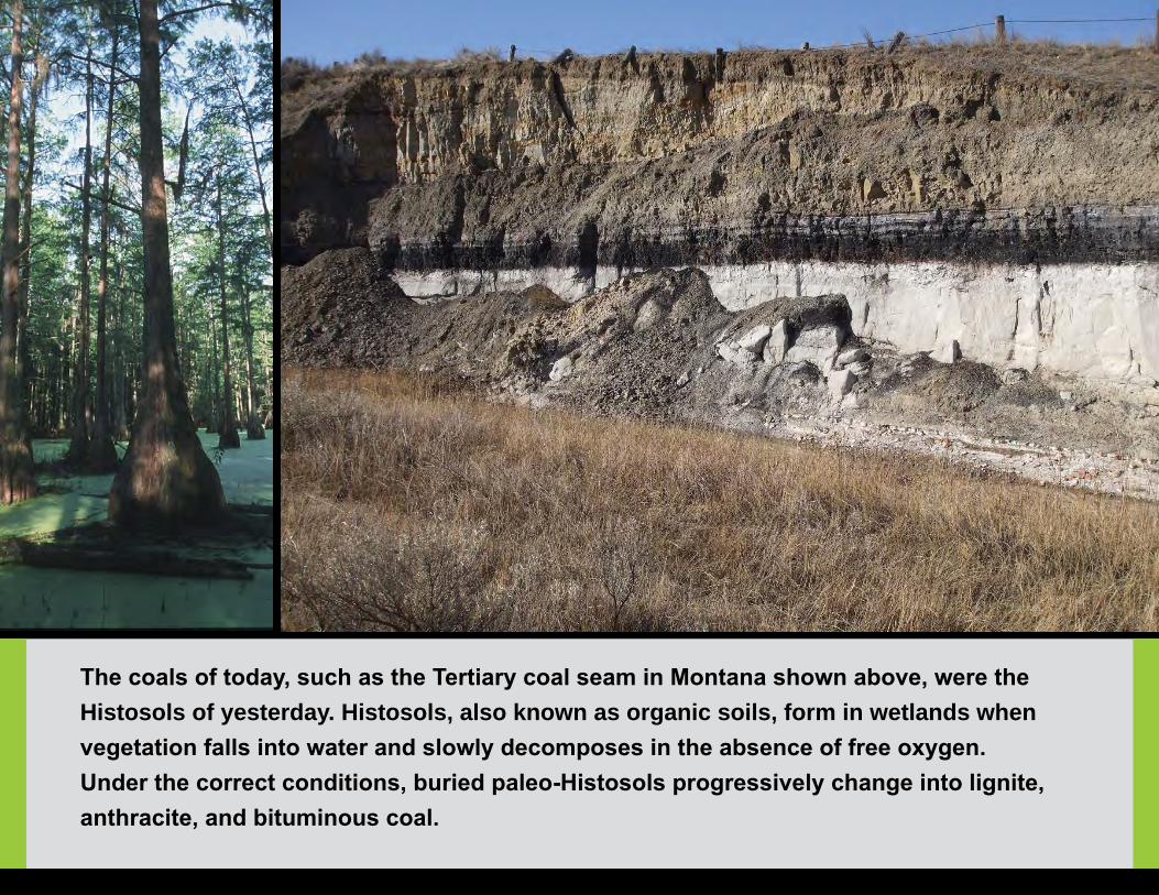
The coals of today, such as the Tertiary coal seam in Montana shown above, were the Histosols of yesterday. Histosols, also known as organic soils, form in wetlands when vegetation falls into water and slowly decomposes in the absence of free oxygen. Under the correct conditions, buried paleo-Histosols progressively change into lignite, anthracite, and bituminous coal.

Vernal EquinoxDaylight Saving Time
Begins
◑
◐
●
○

Desert Shrubland (high erosion)
Semiarid Grassland(low erosion)
Paleosols can record the expansion and contraction of deserts. Erosion is extensive in desert shrublands because vegetation is sparse and soils are exposed. Erosion is limited in neighboring semiarid grasslands where grasses hold soils in place. During desert expansion, erosion causes materials from upslope to bury soils downslope. During desert contraction, the region is covered with grass, the landscape stabilizes, and soil horizons form. A stacked sequence of paleosols at a desert-grassland boundary provides a record of the desert expansion and contraction driven by natural cycles of climate change. The Pleistocene paleosols in New Mexico are an example.

Earth Day
◑
◐
●
○

Dinosaur Tracks
Cycads
Dinosaur FootprintSoil formation, or “pedogenesis,” is the process that creates soil horizons. Correlations between the horizons and the environment make paleosols valuable fossils with clues about former climates. Pedogenesis, however, can also destroy fossils. If plant and animal fossils are at shallow depths, pedogenesis turns these fossils into soil horizons.
Shown above is an area where dinosaurs once walked across a moist beach during the Jurassic period. At that time, cycads were the most abundant plant type. The once-moist beach and footprints survived to become rock in arid Wyoming because they were buried below the zone of pedogenesis.

MemorialDay
◑
◐
●
○
Warm-Humid Forest
Ultisol Soil Profile
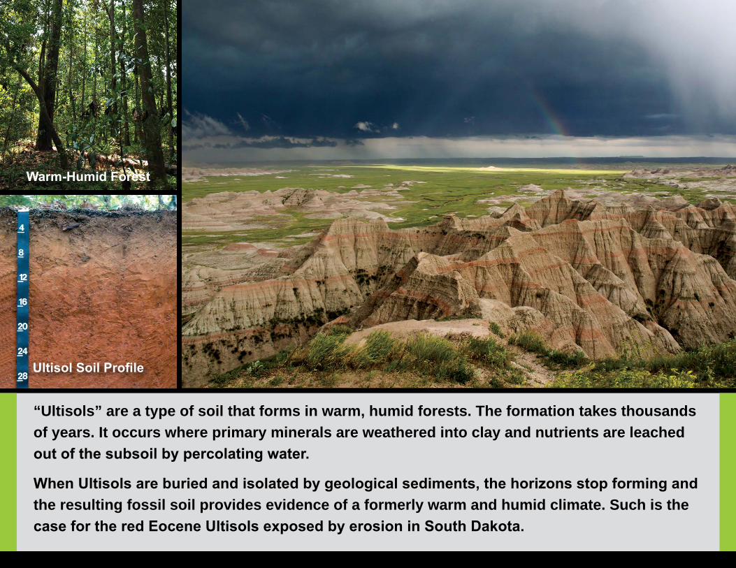
“Ultisols” are a type of soil that forms in warm, humid forests. The formation takes thousands of years. It occurs where primary minerals are weathered into clay and nutrients are leached out of the subsoil by percolating water.
When Ultisols are buried and isolated by geological sediments, the horizons stop forming and the resulting fossil soil provides evidence of a formerly warm and humid climate. Such is the case for the red Eocene Ultisols exposed by erosion in South Dakota.
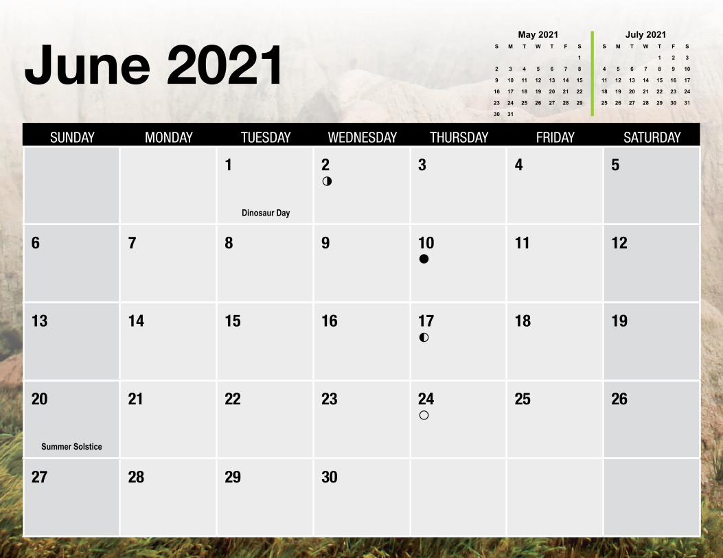
Dinosaur Day
Summer Solstice
◑
◐
●
○

Paleosols are common in landscapes that were buried by wind-blown silt (loess) on the leeward side of barren flood plains and dune fields. Like other paleosols, soils buried by loess record the climatic and vegetative conditions at the land surface before burial. Loess paleosols can be dated using a technique that measures the length of time that the silt particles have been buried.
Most loess soils, which are primarily Pleistocene in age and linked to glacial cycles, have been converted to agriculture. Loess soils are some of the most productive soils on Earth.

Independence Day
◑
◑
◐
●
○
Soil and Water Conservation Society (SWCS) International Annual Conference

Vertisol with Gilgai Microtopography
Slickensides
Miocene Vertisol in Oregon displaying wedge-shaped peds
How long can a buried soil remain recognizable given that pressure, heat, and cementing fluids turn sediments into rock? It depends on the “diagenesis,” or rock-forming processes, and the durability of the soil features. The granular structure and organic matter in surface horizons change faster than the subsoil accumulations of clay, ratios of chemical elements, and the structural units “peds.”
Soils classified as “Vertisols” have wedge-shaped peds with polished surfaces and distinctive microtopography that make them some of the most easily identifiable paleosols in the geologic record. They commonly stretch in age back to the Paleozoic.

◑
◐
●
○

Dapplegrey Soil
Excavated Tar Pit
ca. 1910
1903 Soil Map
Los Angeles
Tar Pit Area
1916 Soil Map
Los Angeles
Tar Pit Area
Naturally occurring tar pits into which prehistoric animals became entrapped provide a valuable paleontological record. The tar pits near Los Angeles, CA, for example, contain fossils of Pleistocene and Holocene animals. Although tar pits are at the land surface and are surrounded by recognizable soil types, the tar pits themselves do not meet the definition of soil.
Interestingly, the pits near Los Angeles were once rangeland but have been progressively engulfed by urban development. See the 1903 and 1916 soil maps above. NRCS is actively remapping some areas to recognize the uniqueness of urban soils, such as the Dapplegrey soil.

Labor Day
Autumnal Equinox
◑
◐
●
○

Volcanic Ash
Volcanic Ash
Calcic Paleosol
Volcanic eruptions bury surrounding landscapes with ash in a geological instant. If the ash is deep enough to bury the soil below the zone of soil formation, the buried soil records the climate in which it formed. If, for example, a buried soil contains calcium carbonate nodules, we know that the climate at the time of burial was arid or semiarid. An example is the Pleistocene calcic paleosol in New Mexico.
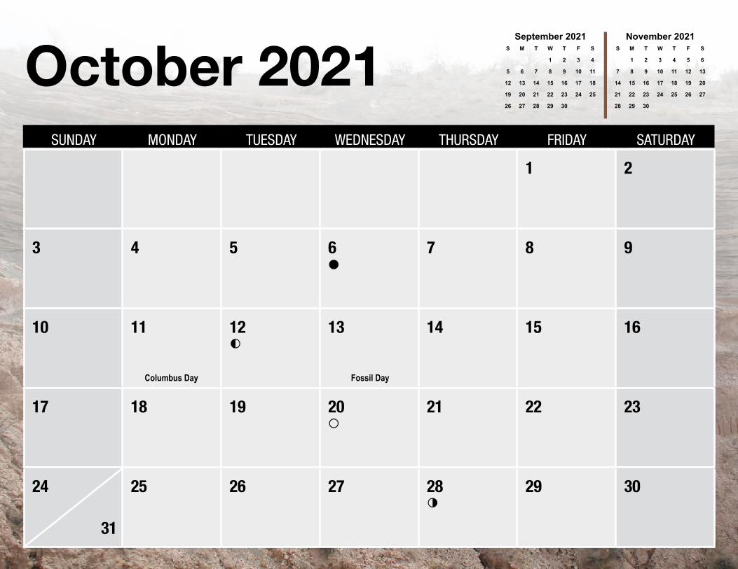
Columbus Day Fossil Day
◑
◐
●
○
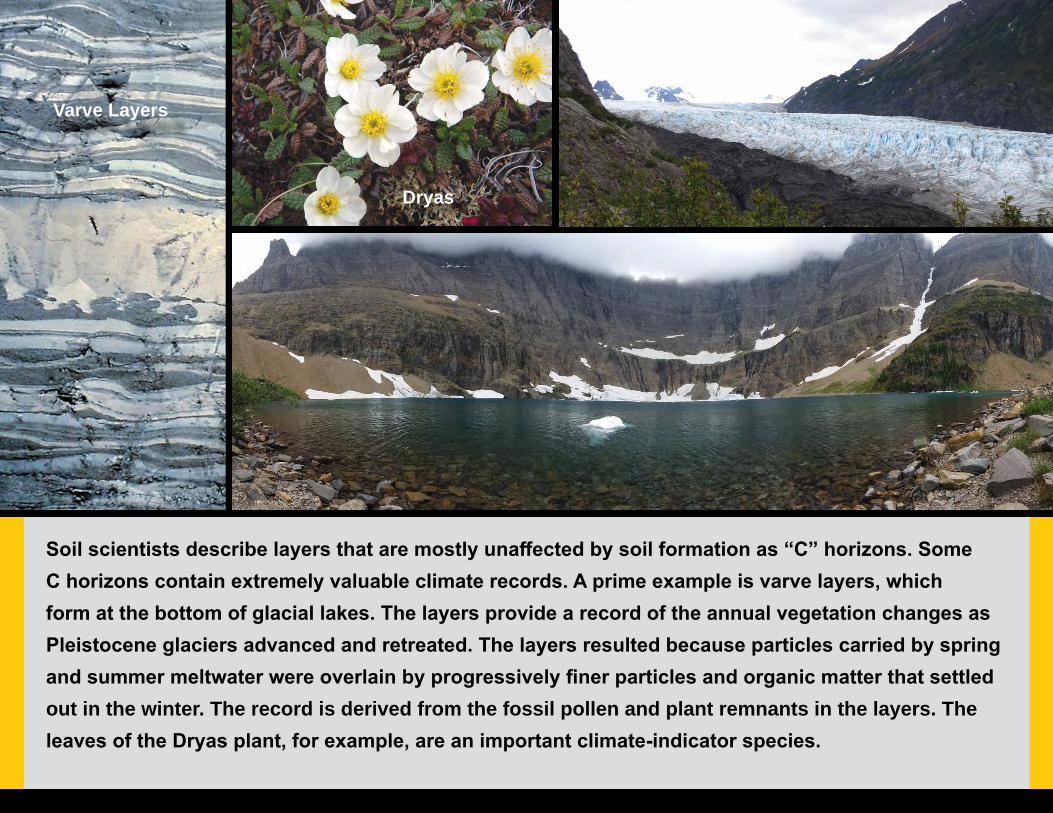
Soil scientists describe layers that are mostly unaffected by soil formation as “C” horizons. Some C horizons contain extremely valuable climate records. A prime example is varve layers, which form at the bottom of glacial lakes. The layers provide a record of the annual vegetation changes as Pleistocene glaciers advanced and retreated. The layers resulted because particles carried by spring and summer meltwater were overlain by progressively finer particles and organic matter that settled out in the winter. The record is derived from the fossil pollen and plant remnants in the layers. The leaves of the Dryas plant, for example, are an important climate-indicator species.
Varve Layers
Dryas

Soil Science Society of America (SSSA) Conference Veterans Day
Thanksgiving Day
Daylight Saving Time Ends
◑
◐
●
○

Not all paleosols are buried. By definition, a paleosol is a soil that formed in a landscape of the past. Some surface soils, therefore, are relict paleosols. An example is “patterned ground” in temperate climates. Patterned ground is a term for well-define polygons and stripes that form in arctic regions as the result of freezing and thawing of the soils.
The example of patterned ground above is in West Virginia. Patterned ground in temperate zones is a vestige from a Pleistocene Ice Age, when colder climates existed farther south than they do currently.

Christmas Day
World Soil Day
Winter Solstice
◑
◐
●
○
in the Geologic Record
Photo CreditsForest ServiceStephanie Connolly, Soil Scientist
National Park ServiceSara Feldt
Natural Resources Conservation ServicePhillip Barber, EcologistGreg Brannon, Soil Scientist (retired)Philip Goodin, Soil ScientistMike Jones, Soil ScientistRobert Mitchell, Soil ScientistCurtis Monger, National Leader Soil Survey StandardsMarji Patz, Ecological Site SpecialistPhil Schoeneberger, Research Soil Scientist (retired) Cathy Seybold, Soil ScientistPerry Sullivan, Soil Scientist
Tufts University, MassachusettsJack Ridge, Professor
U.S. Geological SurveyRandall Orndorff, Research Geologist
Special Thank YouAdditional photos were used with permission from the following:
Bureau of Land Management, Wyoming(Red Gulch Dinosaur Tracksite, Paleontology Area)
National Park Service, National Monument Oregon (John Day Fossil Beds)
National Park Service, South Dakota (Badlands)
National Park Service, Utah (Canyonlands)
The Natural History Museum of Los Angeles County (La Brea Tar Pits)
Front Cover Photo Near Cody, Wyoming
Back Cover Photo Bull Pass and Wright Valley
Victoria Land, Antarctica
2021 Soils Planner T eam, USDA–NRCSMarji Patz, Theme Concept Developer
Ann Kinney , Coordinator/EditorCurtis Monger, AuthorAaron Achen, Editor
Kristina Wiley, Graphic Designer John Andreoni, Approval Coordinator
USDA is an equal opportunity provider, employer, and lender.
PA-2264 August 2020