· Web viewSmall, waxy leaves & long tap roots to reach down to water table and/or shallow roots...
36
Updated for 2018 Syllabus © Copyright 2018 This document contain images and excerpts of text from educational resources available on the internet and printed books. If you are the owner of such media, text or visual, utilized in this document and do not accept its usage then I will immediately replace said media. No part of this document may be copied or re-uploaded to another website without the express,
Transcript of · Web viewSmall, waxy leaves & long tap roots to reach down to water table and/or shallow roots...

Updated for 2018 Syllabus
© Copyright 2018
This document contain images and excerpts of text from educational resources available on the internet and printed books. If you are the owner of such media, text or visual, utilized in this document and do not accept its usage then I will immediately replace said media.
No part of this document may be copied or re-uploaded to another website without the express, written permission of the copyright owner..

CIE IGCSE GEOGRAPHY (0460)May 2018
Page 3 of 19
POPULATION DYNAMICS REASONS FOR POPULATION EXPLOSION
Improved medical care – vaccinations, hospitals, doctors, new drugsand scientific inventions
Improved sanitation and water supply Improvements in food production (quality & quantity) Improved transport – moving food, doctors etc. Decrease in child mortality
MAIN COMPONENTS INFLUENCING POPULATION GROWTH
Migration: movement of people (or animals) from one country or region to another
Birth rate: average number of live births in a year for every 1000 people
Death rate: average number of deaths for every 1000 people Fertility rate: The average number of children a female is expected to
have in their lifetime.
RELATIONSHIP BETWEEN POPULATION GROWTH AND
RESOURCE
S Population growth is related to the amount of resources available for
example water, wood and minerals
HIGH DEATH RATES IN LEDCS
Poor health care/few hospitals/doctors/nurses/clinics Poor sanitation/poor hygiene/lack of toilets/dirty places Poor access to safe/clean water/water borne diseases Limited food supplies/malnutrition/starvation HIV/AIDS Natural disasters/drought/flood Lack of vaccinations/medicines/cannot cure diseases Lack of education about healthy lifestyles e.g. smoking/diet Lack of provision for elderly e.g. pensions/old people’s homes
LOW BIRTH RATES IN MEDCS
Availability of contraception/family planning/abortions Educated in contraception/family planning Able to afford contraception/family planning/abortions Traditionally small families Expense of bringing up children Many women have careers/women are educated; Availability of pensions Low infant mortality rate Lack of religious beliefs/don’t object to contraception
PROBLEMS
OF
Carrying Capacity: number of people the environment can supportwithout there being negative effects to the population.
Optimum Population: amount of people that a region/country can ecologically support, usually less than carrying capacity.
Under-population: when country has declined too much that it can’tsupport its economic system.
Overpopulation: too much population of an area: overcrowding, depletion of resources.
Population Density: number of people living in a given area (km2)
Overpopulation Unemployment Shortage of hospitals/schools Shortage of housing Congestion Inflation (excess demand) Shortage of water & electricity Nosie, air & water pollution
Underpopulation
Shortage of workers Less paying taxes Schools, hospitals & transport
routes close; few customers Less innovation/development Hard to defend Have to attract migrants
Population Distribution: how a population is spread out around a country or an area
DEMOGRAPHIC MODEL
OriginsHIV/AIDS
o HIV-1 – arose in Central Africao HIV-2 – arose in West Africa
HIV mostly occurs in women. When women give birth, they infect thechild as well resulting in low death rate for infants.
Death rate of mothers results in a higher orphan generation. (Year2000 – 600 000 orphans). Due to the countries being poor, there is alack in state welfare, resulting in poverty and lack of education.
POPULATION PYRAMID GENERAL FORMATS
Population Pyramid: a type of graph that shows the age and sex structure of the country.
�������� 𝑦� 𝑟𝑎����� =𝑁�� − �
������� 𝑎� � 𝑦� �

CIE IGCSE GEOGRAPHY (0460)May 2018
Page 4 of 19
× 100FACTORS INFLUENCING DENSITY OF POPULATION
Stage 1: high birth rate; high death rates; short life expectancy; less dependency (since there are few old people and children have to work anyway)
Stage 2: high birth rate; fall in death rate; slightly longer life expectancy; more dependency as there are more elderly
Stage 3: declining birth rate; declining death rate; longer life expectancy; more dependency
Stage 4: low birth rate; low death rate; highest dependency ratio;longest life expectancy
Causes of Sparse Population
Mountainous area Very hot or very cold area A heavily forested area Areas that flood a lot No jobs Poor supply of electricity, gas
and water Poor communications Shortage of natural resources No schools or hospitals Regular natural disasters
Causes of Dense Population Coastal areas Flat relief; easy to build on Close to a supply of water Areas with natural resources Fertile agricultural land Developed transport links Plenty of available jobs Available electricity and water Good communications Good quality schools/hospitals

CIE IGCSE GEOGRAPHY (0460)May 2018
Page 5 of 19
MIGRATION Migration: movement of people from one area to another
SITE AND SITUATION
Site: describes the physical nature of where a settlement isCauses of Voluntary Migration
Find a job, or a better paid job Pioneers developing new areas Trade & economic expansion Territorial expansion Better climate Social amenities Be with friends/family
Causes of Forced Migration
Avoid religious/political persecution
Avoid war Slavery/prisoner of war Racial discrimination Famine Natural disasters Overpopulation
located – the actual piece of land Situation: describes settlement in relation to other settlements
and physical features around it – this determines whether or notthe situation will grow into a large city or remain a small town or village
PHYSICAL FACTORS
Wet point sites: these have a good water supply Dry point sites: these are away from the risk of flooding Building materials: availability of things like stone, wood, clay etc.
Internal migration is within a country e.g. rural/urban, regional External or international is between countries e.g. Negro slaves to
America (forced) or Mexicans into the US (voluntary) Emigrant: A person who leaves a country to migrate to another. Immigrant: A migrant arriving in a new country.
Advantages DisadvantagesLosing Country
Defensive sites: within a river meander or on a hill with steep sided and commanding views
Fuel supply: for heating and cooking Food supplies: land suitable for rearing animals and growing crops Nodal points: where routes converge Bridging point: may originally have been at a ford in the river or
where river was shallow enough to build a bridge Reduces pressure on
resources Decline in birth rate Migrants bring back new skills Money is sent back
Loss of people in working age
Loss of educated/skilled people
Division of families Left with elderly population
Aspect: settlements often found on sunny side of a deep valley
Shelter: from cold prevailing winds and rain.
FUNCTIONS
Rural Areas: tend to have a lot less functions than urban areas.
Gaining Country The main purpose of settlements in rural areas is normally
Overcomes labor shortage Dirty unskilled jobs done Will work long hours for low
salary Cultural advantages and links
Pressure on jobs
Low quality & overcrowded housing
Racism Language problems Less healthy Less religious amenities for
immigrants
agriculture and possibly tourism. This is because rural areas haveless people, poorer transport, poorer communication, lesstechnology and the land is better used for other purposes.
Urban Areas: tend to have a lot more functions ranging from shopping functions, to educational functions, to transport functions, to administrative functions and residential functions.The bigger the urban area, the more functions that it normally has.
Urban Sprawl: The spread or growth of an urban area into theREFUGEES AND
IDPS Refugees: A person who has been forced to leave their home and
their country. This might be because of a natural disaster, war, religious or political persecution.
Persecution: When someone is attacked for what they believe in e.g. their religion or political belief.
Internally displaced person (IDP): When someone has been forced to leave their home but not their country.
Asylum Seekers: Someone who is trying to get refuge (residency) in a foreign country because their life is in danger in their home country, usually because of their political or religious beliefs.
SETTLEMENT PATTERNS OF RURAL
SETTLEMENTS
rural-urban fringe HIERARCHY
An isolated,
building or a group of two or
three buildings, separated from the next by 2 or 3 km.

CIE IGCSE GEOGRAPHY (0460)May 2018
Page 6 of 19
Buildings are strung along a line of communication, for example a main road, a river valley, or canal
Buildings are grouped together, initially for defense, or a common resource.
Determining order of importance:o The population sizeo The range and number of serviceso The sphere of influence
Sphere of Influence: The distance or area people travel from to
access a service. Services:
Facilities that are offered to people e.g. supermarket. Services have a threshold population, which helps explain whybigger settlements have more services.
Range: This usually refers to the number of different services e.g. a school, a post office, etc.

URBAN PATTERNS IN LEDCS
Model of a typical LEDC city:
Both MEDC and LEDC cities have a CBD - often oldest part of city. In LEDCs, poorest housing is found on the edge of the city, in
contrast to MEDC cities Areas of poor quality housing found on the edge of cities in LEDCs
are called squatter settlements or shanty towns Favelas: illegal settlements created due to massive influx of people
LAND USE MODELSBurgess (concentric)
Based on idea that land values are highest in the center
Because competition is high in central parts of the settlement
Limitationso Model quite old &
developed before mass car ownership.
o New working/housing trendo Every city is different
Hoyt (sector)
Based on circles in Burgess model, but adds sectors of similar land uses in parts of the city.
Some zones, e.g. industry zone, radiate out from the CBD, probably following the line of a main road or a railway.
PROBLEMS OF URBAN GROWTHFor People
Overcrowded Unable to obtain jobs/low pay Pressure on schools/hospitals Increased crime rates Difficulties of waste/litter Traffic congestion Noise pollution Lack of sanitation Poor quality of life Food shortage
For Environment Loss of vegetation Loss of habitats Impacts on food chains Pollution of rivers Death of fish/other species Pollution of ground water Air/atmospheric pollution Rivers dry up
URBAN RENEWAL
Reasons for it Older properties fallen into
disrepair/high cost of repair; Use land more intensively; demand for apartments
Why people want keep old houses and improve them
Older houses retain culture Old houses often large/well
constructed; People can’t afford to move;
CIE IGCSE GEOGRAPHY (0460)May 2018
Page 7 of 19
Threshold Population: The minimum amount of people required for a service to be offered and remain open.
High Order Goods (Comparison): Goods that people buy less frequently. They tend to be more expensive and people will normally compare quality and price before purchasing e.g. a car
Low Order Goods (Convenience): Goods that people buy every day. They don't usually cost much money and people would not normally travel far to buy them e.g. bread and milk.
CENTRAL BUSINESS DISTRICT (CBD) The CBD:o Centre point of the city and has highest land priceso Most accessible point in the cityo High-rise buildings and skyscrapers
Functions: retail, entertainment, financial services and other professional services
Land uses:o Leisure and recreation - may include open lando Residential - High/multi-storey buildings.o Transport - road and rail networks, stations and airportso Business and commerce - offices, shops and bankso Industry - factories, warehouses and small production centers
The CBD is located in the center because it is:o A central location for road/railways to convergeo The most accessible location for workerso Accessible to most people for shops and businesses
Problems that CDB face: congestion, pollution and lack of space
RESIDENTIAL AREAS
Old inner city area (a.k.a. twilight zone):o Typically found next to CBDo Has mainly terraced houses in a grid like pattern.o Originally built to house factory workers who worked in inner
city factories (now closed down). Suburbia:o Urban sprawl and owning cars led to construction of
well- planned and spacious houses.o Usually larger than inner city terraces and most have a garden.o Typically, detached or semidetachedo Roads are arranged in cul-de-sacs (dead-end) and wide
avenues.o Land prices cheaper than in CBD and inner city,
although demand can make some areas expensive. Outer city estate:o Located on the fringes of cities with varied types of housingo people relocated here when inner city was being redeveloped
The rural urban fringe:o This is found at the edge of a town or cityo Mixture of land uses e.g. housing, golf courses, allotments,
business parks and airports.
INDUSTRIAL AREAS
Factories were built:o As close as possible to the CBD but with enough spaceo Next to canals and railways to transport materials,o Next to rivers for cooling, power source or waste disposalo Next to land where lots of workers could live.
FUNCTIONS AND SERVICES IN A VILLAGE
Villages - low order services, services in towns will be higher order Mainly/entirely convenience goods, whilst towns will offer
specialist/comparison Examples of village services (e.g. post office, church/mosque)

CIE IGCSE GEOGRAPHY (0460)May 2018
Page 8 of 19
Services which require small threshold population; Services which have small sphere of influence

Constructive: occur when two platesmove away from each other.
Example: NorthAmerican andEurasian Plate
Conservative: occur when two platesslide past each other.
Example: NorthAmerican Plate and the Pacific Plate
Destructive: occur when oceanic plate issubducted by a continental plate.
Example: Pacific Plate and the Eurasian Plate
DISTRIBUTIOPlate boundary Volcanoes? Earthquakes? Fold mountains?
Constructive Gentle Gentle NoDestructive Violent Violent YesCollision None Violent YesConservative None Violent No Earthquake:
o Encircle the whole of the Pacific Oceano Extend down entire length of the mid-Atlantic Oceano Stretch across southern Europe and Asia
Volcanoes:o Encircle the whole of the Pacific Oceano Extend down the entire length of the mid-Atlantic Oceano Some in southern Europe, the Caribbean and east Africa
FOLD MOUNTAINS
At a destructive plate margin, the oceanic plate is subducted whilst the continental plate is crumpled upwards to form a mountain range
At collision margins, both plates forced upwards in a series of folds Two types of fold mountainso Young: 10 to 15 million years of age e.g. Rockies and Himalayaso Old: Over 200 million years of age e.g. Uralas and Appalachians
Created by uplift and folding of tectonic plates as they move towards each other and collide
Movement of two plates forces sedimentary rocks upwards into a
VOLCANOE
S A vent in the earth's surface where magma, gas or ash escapes
onto the earth's surface or into the atmosphere. Causes:o At constructive margin: plates move away from each other;
magma rises to fill the gap;o At destructive margin: oceanic crust melts from friction and
CIE IGCSE GEOGRAPHY (0460)May 2018
Page 9 of 19
Building of houses with better amenities/or examples;
New road developments; New leisure/shopping centres;
Community spirit;
Cheaper option for authority; To restrict outward expansion
CONTROLLING URBAN GROWTH Greenbelts: area of land around urban areas that is protected from
development. Stops greenfield sites being built on and alternative like brownfield sites being used.
Urban Wedges: urban growth allowed to take place in wedges ensuring some green areas protected throughout city
Brownfield sited: increasing building on brownfield sites allows less pressure to be put on rural areas
Housing density: increasing housing density means less land will be destroyed
AdvantagesGREENFIELD SITES
Disadvantages Land never used – not polluted Often near rural-urban fringe
so good transport links Less congestion Room to expand
Conflicts with other land users
Many sites are now protected by the government
Public protests for building on greenfield site
Advantages Often cheap to buy Near the CBD
BROWNFIELD SITESDisadvantages
Site polluted – expensive to clean up
Closer to transport routes No room to expand May not be in desirable shape
or location
PLATE TECTONICS TECTONIC PLATES
Oceanic crust: younger, heavier, can sink and is constantly beingdestroyed and replaced
Continental crust: older, lighter, cannot sink and is permanent Plate movement is caused by convection currents in the mantle
PLATE BOUNDARIESDiagram Description
Collision: occur when two continentalplates move towards each other.
Example: Indo- Australian and the Eurasian Plate

CIE IGCSE GEOGRAPHY (0460)May 2018
Page 10 of 19
EARTHQUAKE A series of vibrations or movements in the earth's crust Caused when two plates ‘stick’; pressure builds up; one plate jerks
forward sending shock waves to the surface
Shock waves
Volcanic plug: lava shoots up, falls down into the vent and solidifies Explosive eruptions can produce mud flows called lahars Active Volcano: A volcano that has erupted recently. Dormant Volcano: A volcano that has not erupted in recent history
but may erupt again in the future. Extinct Volcano: A volcano that is unlikely to ever erupt again,
because no magma is being produced under it.
Features
Focus: point of earthquake Epicenter: point directly above
the focus, on the ground Seismic waves Shaking ground Subduction zone: occurs at
destructive margin, one plategoes under the other
Prediction Measure earth tremors,
pressure, and release of gas Use maps and facts to find
pattern in time/location Unusual animal behavior
Effects
Large number of deaths Fires breaking out Water pipes burst Water contamination,
diseases Corpses: human & animal Accessibility difficult Building damaged/destroyed Tsunami can follow Reconstruction costs
Preparation Build earthquake-proof
buildings and roads Train emergency services Set up warning system Create evacuation plan Emergency food supply Practice drills
Gentle slopes, slow flowing lava
Advantages
Steep slopes, violent eruption
Mix of cone and shield, eruption
varies in strength,made of layers of ashand lava (unstable)
Disadvantages
Earthquake-Proof Buildings
Computer-controlled weights on roof to reduce movement Fire-resistant building material No bricks or reinforced concrete block Rubber shock-absorbers between foundations and superstructure Foundation sunk deep into bedrock avoiding clay Roads to provide quick access by ambulances and fire engines Open areas where people can assemble if evacuated Automatic shutters come down over the windows Interlocking steel frames which can sway during earth movements
Tourist attraction: income andemployment
Creates fertile soil: good agricultural land to grow crops
Geothermal heating:o Natural
renewable resource
o Heating (hot water)o Geyser and mud baths
Prediction Tremors within volcano Ground temperatures rises,
detect by heat-seekingcameras
Volcano swells and bulges Volcano emits gas and steam Animal behavior changes
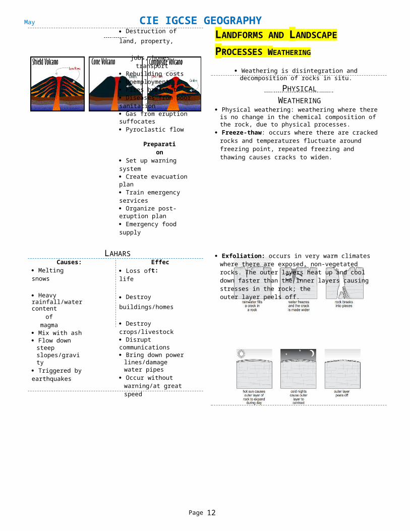
Destruction of land, property,
jobs, homes, transport Rebuilding costs Unemployment Fires breakout Diseases from poor sanitation Gas from eruption suffocates Pyroclastic flow
Preparation Set up warning system Create evacuation plan Train emergency services Organize post-eruption plan Emergency food supply
LANDFORMS AND LANDSCAPE PROCESSES WEATHERING
Weathering is disintegration and decomposition of rocks in situ.
PHYSICAL WEATHERING
Physical weathering: weathering where there is no change in the chemical composition of the rock, due to physical processes.
Freeze-thaw: occurs where there are cracked rocks and temperatures fluctuate around freezing point, repeated freezing and thawing causes cracks to widen.
Causes: Melting snows
LAHARS
Loss of lifeEffect:
Exfoliation: occurs in very warm climates where there are exposed, non-vegetated rocks. The outer layers heat up and cool down faster than the inner layers causing stresses in the rock; the
Heavy rainfall/water contentof magma
Mix with ash Flow down steep
slopes/gravity Triggered by earthquakes
Destroy buildings/homes
Destroy crops/livestock Disrupt communications Bring down power
lines/damage water pipes
Occur without warning/at great speed

CIE IGCSE GEOGRAPHY (0460)May 2018
Page 11 of 19
outer layer peels off.

Middle Lower
HYDROLOGICAL CYCLE
CHANGES DOWN THE RIVERLong Profile:
Cross Profile:Upper
Course Long Profile Cross ProfileUpper Steeply sloping
towards the lower sections of the river.
Steep sided v-shaped valley.Thin river channel, deep in places.
Middle Shallow slopestowards the mouth of the river.
V-shaped valley remains with awider valley floor and the river begins to meander across it. The river channel begins to widen and become deeper.
Lower Almost at sea level,very gently sloping towards its mouth.
Wide, shallow valley, with largeflood plains and meanders. The river channel is wide, deep and smooth sided.
Bed: the bottom of the river channel. Bank: The sides of the river channel. A river has two banks. Wetted perimeter: length of bed and banks in contact with river. Channel: The route course (between bed and banks) that a river
flows. The flow of the river is often described as channel flow. Thalweg: The fastest part of the river, always near the middle of
the river channel, where there is least friction.
CIE IGCSE GEOGRAPHY (0460)May 2018
Page 12 of 19
BIOLOGICAL WEATHERING Biological weathering: roots widen weaknesses in the rock until
part of the rock detaches
CHEMICAL WEATHERING
Chemical weathering: occurs in warm, moist climates Carbonation: Carbon dioxide in air reacts with rainwater and
forms carbonic acid/acid rain. This reacts with calcium carbonateor chalk forming calcium bicarbonate or calcium hydrogen carbonate which is soluble in water. this widens/ deepen cracks
Oxidation: If rock contains iron, it is oxidized in the presence of water forming iron(III) oxide (Fe2O3) or rust. This gives the rock a reddish brown colour. The rock is weakened & eventually crumbles away.
WEATHERING IN HUMID TROPICAL AREAS
Tropical areas tend to experience more weathering because of: Large amounts of rainfall increasing chemical weathering Large amounts of vegetation increasing biological weathering They are nearer to the equator so there are high temperatures
and faster rates of chemical reaction Some areas (high areas and desert areas) have higher diurnal
temperature range.
RIVER TERMINOLOGY Drainage basin: the area of land drained by a river. Watershed: the edge of highland surrounding a drainage basin. It
marks the boundary between two drainage basins. Source: the beginning or start of a river. Confluence: the point at which two rivers or streams join. Tributary: a stream/smaller river which joins a larger stream or
river. Mouth: point where river comes to end, usually when entering
sea
RIVER PROCESSES
Drainage basins act as a system with:o Inputs: precipitationo Transfers: infiltration, percolation, surface runoff, throughflow
& groundwater flowo Stores: interception, surface storage, soil moisture storage &
groundwater storageo Outputs: evaporation & transpiration or evapotranspiration
CIE IGCSE GEOGRAPHY (0460)May 2018
Page 13 of 19
TRANSPORTATION
Traction: rolling stones along the bed
V-shaped valley:LANDFORMS
Saltation: small particles bounce along bed in a leapfrog motion Suspension: silt and clay-sized are carried within the water flow Solution: minerals dissolve in the water
EROSION
Attrition: large particles such as boulders collide and break into smaller pieces (occurs at higher part of river)
Hydraulic action: the sheer force of the river dislodges particles from its banks and bed
Abrasion: smaller particles rub against the river banks and bed like sand-paper; occurs at low part of river (smaller particles)
Solution: acids in river dissolve rocks (occurs at any part of river)
DEPOSITION
When a river lacks the energy to carry its load; it begins with the heaviest particles; happens when there is less water or where the current slows down.
Large boulders are deposited at the top, and very small particles are deposited at the end, resulting in sorting.
BRADSHAW MODEL
o Valley is narrow with a narrow, shallow river channel
o Valleys have steep sideso Channel has a
steep gradiento Water is mainly slow
flowing as most of the rivers energy is used to overcome the friction of the river bed & obstructions
o Load is mainly large, angular and rough
Interlocking spurs: In the upper valley a river is in the mountains. Water takes the easiest path downhill so twists & turns around the high land (spurs) forming interlocking spurs.
Waterfalls:o They occur because the river flows over hard rock
which erodes slowly.o Beneath is softer rock which is eroded faster to form a “step”.o The force of the water erodes the bottom of the waterfall to
form a plunge pool.o The hard rock gets undercut as the soft rock erodes so that
it eventually collapses.
Rapids: They form also where the river passes over hard rock, but either the band of rock is not very deep or there are a series of shallow rock bands.
Potholes: Can be found in the upper & middle valley where a river flows over solid rock.
Meanders:o Wide sweeping bends found
in the lower part of the river.o They are formed by a
combination of lateral erosion& deposition.
Ox-bow Lakes:o Form when the neck of the meander becomes very narrow.o During high flow or floods the river cuts through the neck &
straightens its course.o Deposition occurs on the bank of the rivero The cut-off meander is an ox-bow lake.

CIE IGCSE GEOGRAPHY (0460)May 2018
Page 14 of 19
Deltas:o Deltas occur where a river that carries a large amount
of sediment meets a lake or the sea. Dams:FLOOD MANAGEMENT TECHNIQUES
o This meeting causes the river to lose energy and drop the sediment it is carrying.
o Deltas form where river mouths become choked withsediment, causing the main river channel to split into hundredsof smaller channels or distributaries.
Levées: when a river floods, the coarsest material is deposited first, on the edges of the river, forming a natural embankment called a levée.
o Often built along the course of a river in order to control theamount of discharge.
o Water is held back by the dam in a reservoir and released in a controlled way which controls flooding.
o Building dams is expensive, can affect farmers and cause erosion downstream
River engineering:o The river channel may be widened or deepened allowing it
to carry more water.o A river channel may be straightened so that water can
travel faster along the course.o The channel course of the river can also be altered,
diverting floodwaters away from settlements.o Altering the river channel may lead to a greater risk of
flooding downstream, as the water is carried there faster. Afforestation:
o Trees planted near to the river meaning greater interception of rainwater and lower river discharge.
o This is a relatively low cost option, which enhances the environmental quality of the drainage basin.
Managed flooding: The river is allowed to flood naturally in places, to prevent flooding in other areas
Planning:o Local authorities and national government introduce
policies to control urban development close to or on floodplain reducing chance of flooding and risk of damage to property.
o However, enforcing planning regulations and controls may be harder in LEDCs
Flood plain:o Area of alluvial deposits found beside the river in its
lower course.o As meanders move slowly down the course of the river they
erode away the valley to create a wide valley floor, and they deposit layers of alluvial material on the slip off slopes building up into a large flood plain
FLOOD HYDROGRAPH
The greater the lag time, the less chance there is of a flood A rise in discharge on the graph is called the rising limb The falling limb shows a decrease in discharge.
TYPES OF WAVESCAUSES OF RIVER FLOODING
Steep-sided channel: a river channel surrounded by steep slopes causes fast surface run-off.
Lack of vegetation or woodland: surface run-off will be high astrees and plants won’t intercept precipitation.
Drainage basin, consisting of mainly impermeable rock: water cannot percolate through rock layer, and will runoff surface
Drainage basin in an urban area: these consist largely of impermeable concrete, which encourages overland flow.
Deforestation, overgrazing and overcultivation, and population pressures cause soil erosion causes sediment to go into rivers decreasing the cross-sectional area
Constructive
Low wave height & usually beach gradient is gentle.
Waves spill forward gently creating a strong swash.
Water drains away through beach material so backwash is weak.
These waves deposit material& build up beaches.
Destructive High wave height & the beach
tends to be steep. Wave plunges forward onto
beach so swash is weak, but rotation of water causes a strong backwash.
These waves tend to erode beaches.

CIE IGCSE GEOGRAPHY (0460)May 2018
Page 15 of 19
Constructive:
Destrictive:
COMPONENTS OF A WAVE
Swash: when a wave breaks & washes up the beach. Backwash: when the water drains away back into the oncoming
wave. The size of waves depends upon three factors:o The strength of the wind.o The length of time the wind has been blowing.o The fetch or distance over which the wind can blow.
METHODS OF EROSIION
Corrasion: large waves hurl beach material at the cliff Corrosion: salts and acids slowly dissolve a cliff Attrition: waves cause stones to collide and disintegrate Hydraulic action: force of waves compresses air in the cliffs
LONGSHORE DRIFT
When waves approach the coast at an angle the swash moves up the beach at an angle.
The backwash, however, drains straight back down the beach. This will gradually move sand/stones along the beach in a zig-zag
motion.
CAVES, ARCHES AND STACKS
A band of weaker rock extends through a headland. More erosion occurs producing caves on both sides of headland Continued erosion produces an arch through the headland. Eventually the roof is weakened & collapses forming a stack
BEACHES
In bays the waves diverge outwards. The wave energy is dissipated creating a low energy environment
hence deposition to form beaches.
BAYS AND HEADLANDS
• Bays are formed due to softer rockgetting eroded easily.
• Headlands are usually formed since they are made of resistant rock and so is eroded more difficultly.
Spits:SPITS AND SALT MARSHES
CLIFF AND WAVE-CUT PLATFORM Wave erosion is concentrated at the foot of the cliff so a wave-cut
notch is formed. The cliff is undercut & collapses. Repeated collapse causes retreat of the cliff producing a platform
of flat rock at the cliff foot extending out to sea.
o Spits form when the coastline changes direction. Longshore drift continues to carry material in the same direction.
o Sand & shingle is built up to form the spit.o End of spit curves due to wave refraction or secondary winds.
Salt marsh:o Mud is deposited by the tides. The beach builds up above
sea level forming mudflats.o Plants start to grow in mud & trap more sediment, forming
a salt marsh. Bars: A spit that connects two headlands or runs across the face
of a small cove (bay)

CIE IGCSE GEOGRAPHY (0460)May 2018
Page 16 of 19
Diagram showing optimal conditions for their growth:
SAND DUNES Sand dunes form behind wide sandy beaches. Onshore winds pick up the dry sand from above the high-water
mark & carry it landward by saltation. Problems faced by mangrove swamps and their solutions: If they encounter an obstacle the wind loses energy & deposits
sand in the lee of the obstacle. Eventually a dune is formed. Plants then grow on it which stabilize
it & trap more sand.
CORAL REEF
Conditions required for growth of coral reef:
Problem Emersion due to overflow of
water Saline environment
Lack of oxygen
Solution
Plants adapt to water environment
Plants have waxy covering prevents entry of salt
Long roots take in air through pores when possibly
o Warm water/seas; temperatures above 20°Co Shallow water; not more than 60 meters deepo Water free from sediment/clear/availability of lighto Plentiful supply of oxygen in water/unpollutedo Plentiful supply of planktono Lack of strong currents
Benefits and drawbacks of mangrove swamps:
Benefits:o Provide habitat and protection many aquatic lifeo Important area for fishing industryo Slows water flow allowing for fertile deposits
Fringing reef Coral reefs grow in
the shallow waterof the coast in tropical areas
Barrier reef Due to plate
tectonics islandstarts to sink
Reef grows to keep up with the sinking, but a lagoon develops between reef & land
Coral atoll These form
around islandsthat are sinking.
Coral growth keeps up with this& island keeps sinking
Eventually island sinks below sealevel forming aring of coral with a lagoon in the centre.
o Protects coast from erosion – dissipates wave energyo Advance outwards – leaves fertile land for settlementso Mangrove wood collected for firewoodo Work like a natural water cleaning system
Drawbacks:o Noxious and impenetrableo Full of disease
Interdependence between Coral Reefs and Mangrove Swamps:
MANGROVE SWAMPS Trees and shrubs that grow in saline coastal habitats Conditions for mangrove swamps to grow:o Topical or subtropical environmento Shore is soft and muddy – easy to take root
Shoreline must be undisturbed for them to prosper
COASTAL DEFENCES
Hard Engineering Rip-rap: giant boulders placed at the foot of cliffs, designed to
absorb waves energy and protect cliffs behind. Can be effective,but does look ugly, reduces access to beach and can be expensive
Gabion: uses large boulders placed in cages which means can be installed quickly and is fairly effective. However, it also looks ugly, reduces access and can be expensive.
Groynes: designed to stop longshore drift transporting away beach material. Can be effective in maintaining a beach, but need replacing regularly, look ugly and can cause problems down coast.
Sea wall: made out of concrete and are aimed to absorb waves energy. Sometimes curved to direct waves energy back out to sea.Very effective, but are expensive, ugly and reduce access

CIE IGCSE GEOGRAPHY (0460)May 2018
Page 17 of 19
Breakwater: are built out into the sea and are a coats first line of defence. Instead of breaking on coast, waves, break on breakwater. Often found around the mouths of rivers and ports. They are expensive and can disrupt shipping and animals.
Revetments: similar to sea walls, but often built out of wood. Found at the foot of cliffs and are designed at absorb the wavesenergy. Need replacing regularly & don’t protect against storms
Soft Engineering Dune Stabalisation: planting vegetation on berm of beach or on
dunes, making them more stable (roots) and reducing the moisture content (root uptake)
Cliff Regrading: make cliffs less steep; reducing angle reduces undercutting and risk of cliff collapsing
Beach Nourishment: adding more sand to the beach. Beaches are natural defences, so by making them bigger, you are creating anatural defence.
Beach Drainage: removing some of the excess water reduces stress on the cliff.
Managed Retreat: allowing sea to take back land. Low value land is often chosen to be flooded by sea.
WEATHER, CLIMATE & NATURAL VEGETATION WEATHER INSTRUMENTS
Rain Gauge: has a fixed diameter so thatthey collect the same amount of water & so comparisons can be made Made of a hollow cylinder (C) containing:o Funnel (A) to collect the water.o Container to collect water which may
be graduated. It is emptied once every24hrs at the same time.
o Rain is measured in millimeters.o Sunk into ground, but not level so
splashes or surface water can’t get inMax-min thermometer: record max. & min. temp. over 24hr period Max thermometer contains
mercury & min contains alcohol As temp. rises, mercury expands &
pushes up a metal index and when it cools, mercury contracts and index is left in place at highest temp.
As temp. falls, alcohol contracts & pulls metal index with it, but as alcohol expands, it flows past index, leaving it in place atlowest temp.
• Both indexes read once every 24hrs from bottom of index.Sunshine Recorder (Heliograph): records the amount of sunshine at a given location Burns a timeline Traces sun shine not the hours of
daylight The glass ball focus the light This burns a line onto the card
Wet & dry bulb thermometer (hygrometer):
Dry bulb is a normal mercury thermometer and it measures actual airtemperature
Wet bulb is same but bulb is covered with a fine cloth which is connected to areservoir of water.
Water evaporates from the cloth & cools the temperature so it reads a few degrees lower than air temp.
Both wet & dry bulb temperatures read
Barometer: Measure air pressure An aneroid barometer has a corrugated
chamber containing a vacuum As air pressure rises & falls, the
chamber contracts & expands. Levers conduct this movement to a
spindle which moves the pointer on thedial which records the air pressure in mm of mercury.
Anemometer: Measures wind speed. Three light rotating cups (mounted on a
high pole) are blown around by thewind the revolutions are counted &converted into m/s, km/h or knots
Wind vane: Records wind direction The fletching is blown by the wind so that
the arrow head points into the wind. Mounted on a high pole.
Stevenson’s Screen: contains the thermometers Painted white to reflect the sun with a double lid for insulation. Slatted sides to let the air circulate, but slanted downwards to
prevent light getting in. Legs 1m long to prevent heating from ground. On short grass so it’s standardized i.e. same amount of
reflectivity.
TYPES OF CLOUDS

CLIMATETropical Rainforest Tropical Desert
Location
Around equator, betweenTropic of Cancer andTropic of Capricorn =
‘tropics’
Between 5° and 30° north and south of
the equator
Mean temp.of hottest
month≈25°C ≈30°C
Mean temp. of coldest
month≈25°C >18°C
Annual temp. range <5°C <5°C
Rainfallamount >2000mm <250mm
Rainfalldistribution Same throughout year Irregular
Wind Low StrongCloud Heavy Almost none
Humidity High LowPressure Low High
FACTORS AFFFECTING TEMPERATURE Latitude: closer to the equator = higher temperature Distance from the sea: coastal area = warmer winters and cooler
summers Prevailing winds: seasonal difference in heating between land
and sea affects temperature of prevailing wind. Warm prevailing wind = rise in temperature
Ocean currents: warm currents raise winter temperatures in coastal areas; cold currents cool them down in summer
Altitude: higher altitude = lower temperature (1° per 100m)Pressure Systems:
Depression AnticycloneAir movement Upwards DownwardsAir pressure Low HighWinddirection
Anticlockwise towardsthe centre
Clockwise away fromthe cente
Isobars Close together Far apart
Associated weather
Short sunny spells;longer periods of wind
cloud and rain
Dry; usually sunny;light winds; nights may
be cold
Frequency All year – mostly insummer and winter Ocassionaly in winter
ECOSYSTEM: TROPICAL RAINFOREST
Vegetation grows in distinct layers. Emergent layer: tall trees up to 50m. Few lower branches. Grow
above others to get full sunlight. Main canopy: trees 30-40m forming a continuous canopy. Few
lower branches. Under canopy: trees 20m high (& young trees) – less dense can
survive in less sunlight. Shrub layer: low shrubs & saplings. Shade plants.Forest floor: little grows except fungi – too little light. Since the trees grow tall, have large buttress roots for support Lianas use large trees as a support in order to reach the sunlight. Epiphytes grow on trees to get light & have hanging roots that
collect rainwater. Leaves shed water easily having drip tips & “channels” to direct
CIE IGCSE GEOGRAPHY (0460)May 2018
Page 18 of 19
Cirrus: found high in the atmosphere, common throughout the world, thin and wispy in appearance and move fairly quickly
Stratus: low level, usually grey in colour, move fast and can produce light rain and snow.
Cumulonimbus: large clouds up to 10km high and across, produce rain, thunder and lightening, usually found in spring and summer
Cumulus: fairly low clouds, look like lumps of cotton wool, can produce light rain and each individual clouds has a short life cycle
WEATHER SYMBOLS Cloud cover: measured in eighths. Hold sheet directly above your
head & estimate the cloud cover directly above you.
Warm and cold front symbols:
Relief Rain Warm moist air
from the sea Forced to rise over
mountain/hill Cools as it rises Condensation Clouds form Rain E.g. West of UK
TYPES OF RAINFALL
Frontal Rain Warm airmass
meets colder airmass
Warm air mass rises over colder
Condensation Clouds form Rain E.g. All of UK in
Winter
Convectional Rain Sun heats ground
which heats air Warm air rises Cools as it rises Condensation Clouds form Rain E.g. South of UK
Weather:o The mix of events that occur in our atmosphere,
including changes in temperature, rainfall and humidityo This can vary from day to day and from place to place
Climate:o This is the average conditions over a longer period of
time, usually a few years

CIE IGCSE GEOGRAPHY (0460)May 2018
Page 19 of 19
INTER-RELATIONSHIPS BETWEEN THE NATURAL ENVIRONMENT
AND HUMAN ACTIVITIESHAZARDS &
OPPURTUNITIES
DEFORESTATION OF TROPICAL RAINFORESTS
Reasons for deforestation:o Farming: demand for food increases with population - need
to clear more usable ground
Environmental Hazards Volcanic eruptions Earthquakes Tropical storms Flooding Drought
Environmental Oppurtunities
Renewavle energy sources:o Droughts = solar powero Volcanic land = geothermal
Medical research and genetic engineering of crops
Flooding = alluvium = fertile Tourism = source of wealth Tropical rainforests = wood
o Hydro-Electric Power: land may need to be removed to build damn or floodable area
o Mining: demand for resources increase – rainforests hold plenty
o Road building: increased congestion requires new roads –rainforest in the way
o Settlements: population increase causes cities to become bigger requiring more land
o Timber: self-explanatory Problems due to deforestation:o Flooding: less interception by vegetation thus more
flash floodso Landslides: removal of vegetation causes soil to
become unstableo Biodiversity Loss: deforestation kills off unknown species,
since they will have no homeo Less Photosynthesis: causes imbalance of oxygen and
carbon dioxide in atmosphereo Silting: rivers, seas and oceans become more difficult
to navigate due to reduced deptho Desertification: soil loses components vital to survival of plants
– become hardo Indigenous: these people lose their homes, more
importantly impact their societyo Less Rainfall: Less interception = less transpiration =
fewer clouds = less rainfall
ECOSYSTEM: TROPICAL DESERT
Plants such as cacti: Have thick, waxy cuticles to reduce transpiration; Fleshy stems to store water; Leaves reduced to spines to reduce surface area for transpiration
& prevent animals eating them & sunken stomata.Shrubs have: Small, waxy leaves & long tap roots to reach down to water table
and/or shallow roots to collect any moisture before it evaporates. Seeds can lie dormant for years. After rain they germinate quickly,
flower & produce seeds within 2-3 weeks.
DEVELOPMENT
Affluence: general level of prosperity enjoyed by population Appropriate Aid: resources suited to basic conditions prevailing in
receiving country Development: progress in terms of economic growth, use of
technology and human welfare Development Gap: difference in standards of living between
richest and poorest countries Free Trade: trade between countries is not restricted by laws and
formalities Quality of Life: often used as an umbrella term taking into account
GDP and human welfare
MAIN INDICATORS
Birth Rate: number of births in a year per 1000 of total population Death Rate: number of deaths in a year per 1000 of total
population Gross Domestic Product (GDP): total value of goods and services
produced annually GDP per Capita: GDP per head of population Human Welfare: condition of population i.e. diet, housing,
healthcare, education, etc. Infant Mortality: avg. number of deaths of infants under 1, per
1000 live births, per year Life expectancy: average number of years a person might be
expected to live Intermediate Technology: simple, easily learned technology used
in economic activities Human Development Index (HDI): measures and compares
international development
GLOBALIZATIO
N Process in which the world is becoming increasingly
interconnected Causes of globalization:o Improvements in transportationo Freedom of tradeo Improvements of communicationso Labour availability and skills

FARMER’S DECISIONSuccessful Year
Buying more land Buying better and newer
equipment e.g. new tractor Improving drainage/irrigation Buying new varieties of seed,
(GM crops) New buildings/more farms
Bad Year Sell some of your livestock Sell some of your land Diversify by opening a shop Try and farm more intensively
by buying more fertilisers andpesticides
FACTORS AFFECTING FARMING Temperature determines crops grown Crops grow where there is an adequate growing season There must be sufficient rainfall for crops to grow Irrigation needed if insufficient rain Cereal crops/vines need sunshine to ripen Too much rainfall may flood crops/require drainage system In areas with frost/long winter hardy animals may be kept If it is windy wind breaks are needed etc. Better/alluvial soil means arable farming otherwise pastoral Flat relief means arable and hilly relief means pastoral
GREEN REVOLUTION
The introduction of modern western style farming techniques inLEDCs during the late 1960's and 1970's.
High Yield Varieties:o Developed to try and end food shortages by increasing yields.o Were first developed by cross pollinating different varieties
Successes HYV did increase food
production and made countries more self-sufficient
Food prices began to fall making; affordable for poor
Shorter growing season, more crops could be grown
The yields were more reliable Different crops were grown
adding variety to local diet There were surpluses so crops
could be traded commercially Farmers became wealthier
Failures Required fertilisers &
pesticides polluted water The HYV were more prone to
disease and drought More water had to be diverted
to growing crops Many poorer farmers couldn’t
afford to buy expensive HYV Mechanisation led to
unemployment Many natural varieties lost Countries & farmers became
dependent on foreigners
MONOCULTURE
Growing of only one type of crop Cash crops: crops that are normally grown in large plantations for
the purpose of selling and making a profitAdvantages Become more efficient Profitable Can have high yields Easily controllable Low training required
Disadvantages If demand falls, no profit Less variety Bad season, no profit Labor becomes deskilled Only source of income
ORGANIC CROPS AND FARMING Farming that uses natural varieties and natural farming
techniques. There is only very limited use of fertlisers.Advantages
Longer to ripen; better flavour Low fertilizer use; less run-off Less chemicals to consumers Higher prices when sold
Disadvantages Crops are not uniform May be susceptible to disease Take longer to grow May need more water
CIE IGCSE GEOGRAPHY (0460)May 2018
Page 20 of 19
IMPACTS OF GLOBALIZATION
Positive impacts of globalization:o Economies of scale, cost per item reduced when operating on
a larger scaleo TNCs helps countries; provide new jobs & skills for local peopleo TNCs bring money and foreign currency to local economieso Allows for sharing of ideas, experiences and lifestyles of
people and cultureso Increases awareness of events in far-away parts of the world
Negative impacts of globalization:o Globalisation operates mostly in interests of richest countrieso No guarantees that wealth from inward investment will benefit
local communityo Profits are sent back to the MEDC where the TNC is basedo TNCS, with massive economies of scale, may drive local
companies out of businesso If cheaper in another country, TNC might close down
factory making locals redundanto Absence of laws may allow TNCs to operate in LEDCs in
ways not allowed in MEDCso Threat to the world's cultural diversity, such as the
traditions and languageso Industry may begin to thrive in LEDCs at expense of jobs in
MEDCs
HumanInputs
Things that
AGRICULTURAL SYSTEMSPhysicalInputs
Process Outputs
The eventsare built or
made by humans and
added on to a farm
Labor/rent Machinery Building Animal feed Fertilizers Pesticide Market
demand Government
controls Seeds
Natural things
that are foundon a farm or added to a
farm
Soil Precipitation Temp. Length of
Season Alluvium Floods Relief Drainage
that take place on a
farm to turn inputs into
ouputs Rearing Shearing Ploughing Fertilizing Weeding Irrigating Cultivating Harvesting Slaughtering Planting
Things that are produced on a famr that are
often sold
Profits Meat
products Wool Milk Waste Crops Pollution Erosion
CLASSIFICATION OF FARMING TYPES1. S p e c i a li sa t i o n
Arable(crops)
2. E c o n o mi c S t a t u s Commercial (for profit)
3. I n te ns i ty o f L a n d U s e Extensive
Pastoral(animals)
Mixed
(both)
Subsistence(to survive)
Intensive Normally a larger farm Few inputs per hectare
Few workers per hectare Low yields per hectare4. La n d te n u r e
Shifting & Nomadic (where
farmers move from one area to another)

CIE IGCSE GEOGRAPHY (0460)May 2018
Page 21 of 19
Normally a smaller farm
High inputs per hectare Lots of workers per hectare High yields per hectare
Sedentary
(farm location is permanent)

CIE IGCSE GEOGRAPHY (0460)May 2018
Page 22 of 19
GM CROPS AND FARMING Genetically modified crops are crops that have their genes altered
to improve quality and/or quantity
An LEDC e.g. Ghana
Majority in primary sector:o Lack of machinery available
in farming, forestry and mining.
Advantages Uniform in shape – easy to
transport/ appeal consumers Growing season shorter Drought resistant – less water Higher yields
Disadvantages
Natural species may die Tastse often not as good Lead to development of super
weeds – stronger than GM No one knows long term effect
on humans
o Farming very important because most eat what they grow.
Few in secondary sector:o Lack of factories because machinery is too expensiveo MNCS manufacture instead
Tertiary may be larger than secondary:o Most informal work is in the tertiary sector
FAMINE
When demand for food exceeds supply of food leading to undernourishment. Prolonged undernourishment can damage people's health and eventually lead to starvation.
o Growth of jobs in tourism
An NIC e.g. Brazil While Brazil’s economic base is
developing, there are still a large
Human Causes Increasing population; supply
cannot keep up with demand Overgrazing reduces integrity
of soil and can cause topsoil erosion and soil degradation.
Overcultivating causes soil degradation, using up and notgiving nutrients recovery time
Deforestation of woodland, damages integrity of soil as well as its source of nutrients.
Farming and industrial pollution can both degrade land and reduce crop yields
Corruption of governmentEffects: Hunger Susceptible to infectious diseases
Physical Causes Too hot or cool temperatures
can kill crops and animals. Shortage of rainfall kills most
crops or require irrigation Too much rainfall can flood &
kill crops or wash away topsoil reducing soils fertility leading to low yield
Natural disasters can destroy large areas of agricultural land and kill or injure farmers.
If soil is infertile because the bedrock contains few minerals it can be hard to cultivate landand lead to low yields.
number of people employed inprimary industries such as farming.
There are a large proportion of people employed in tertiary industries.
One reason may be growth of Brazil as a tourist destination. Also, there have been significant improvements in the provision of
health care, education and transport.
THE INDUSTRIAL SYSTEM
Input: resources which may be physical (natural) such as iron ore or human (artificial) such as labour.
Processes: turning raw materials into usable things such as steelmaking and also turning usable things into other things forexample assembling cars.
Outputs: profit or loss + waste materials
LOCATING AN INDUSTRY
Physical Factors Power/energy: the industry should be near the raw materials or a
port/station where the materials come from Impair physical and mental development Reduce labour productivity
INDUSTRIAL SYSTEMS
SECTORS Primary industry: industry, such as farming, fishing, forestry and
mining that extracts raw materials directly from the land or sea. Secondary industry: an industry that processes or manufactures
primary raw materials, assembles parts made by other industries or is part of the construction industry.
Tertiary industry: an occupation, such as health, education, transport and retailing, which provides a service to people
EMPLOYMENT STRUCTURES
An MEDC e.g. the UK Low proportion in primary sector:o Mechanizations of jobs in primaryo Primary resources exhausted
o Resources are now imported. Numbers falling in secondary sector:o Mechanization - as machines are
taking over jobs in factories. Tertiary sector is main growth area:o Most work in hospitals, schools, offices & financial serviceso Greater demand for leisure services as people have more free
time and become wealthier.o More jobs become available in the tertiary sector.

CIE IGCSE GEOGRAPHY (0460)May 2018
Page 23 of 19
Natural routes: river valleys and flat land is good for transport
Site and land: flat land & enough space might be needed, cheap land
Human & Economic Factors
Labour: quantity (industry might need many people) and/or quality (very-skilled workers, close to a university)
Capital: (money) Markets: size and location of market Transport: cost increases when items are bulky (steel), fragile
(glassware), heavy (steel) or perishable (fruit/veg.) Government policies Leisure facilities: countryside views / amenities
Hi-Tech Industries
High-tech industries are footloose as they do not need to be near raw materials so are located:o In a pleasant working environment near to large markets
and major transport routes. ORo Companies (especially foreign) may be tempted by the
government to locate in former industrial areas which often had higher levels of unemployment
LEISURE ACTIVITIES AND TOURISM
Tourism: the occupation of providing information, accommodation, transportation and other services to tourists.

Gas
Oil
Coal
CIE IGCSE GEOGRAPHY (0460)May 2018
Page 24 of 19
FACTORS THAT LEAD TO CHANGES IN TOURIST PATTERNS Transport and accessibility: access to various means of
transportation such as trains, cars, planes, ships etc. Scenery: the landscape and visual appearance of a place. Weather: depending on the type of vacation wanted, climate is
important e.g. for a ski trip, a cold destination is necessary. Accommodation: quality of hotels, camps, resorts, parks and their
affordability. Amenities: the various recreational, historical, leisure facilities
and sites that are offered and can be accessed.
REASONS FOR INCREASE IN TOURISM
Greater affluence: higher salary + holiday with pay Greater mobility: increase in car ownership + more aircraft Improved accessibility and transport facilities:
Consolidation: Growth continues with resources diverted to tourism sector. Areas may change to the exclusive use of tourists, possibly alienating locals.
Stagnation: Increased opposition to tourism, tourist facilities may become tired and number of tourist arrival plateaus or declines.
Rejuvenation: A tourist destination rebrands itself or improves tourist facilities, offers promotions or improves transportation.
Decline: No improvements are made to the tourist destination and the number of tourists continues to declines.
ECOTOURIS
M Ecotourism: Holidays that involve eco-related activities and are
sustainable e.g. hiking, bird-watching, horse riding, etc. Sustainable tourism: Tourist activities that are socially,
environmentally and economically sustainable.How Ecotourist Resorts Can Be
o Better roadso Larger airports, online reservation, package holidays
More leisure time: longer vacations, shorter working hours, people work from home, more elderly
Changing lifestyles: changing fashions, earlier retirements Change in recreational activities Advertising of holiday destinations: TV and the Internet Green tourism
ADVANTAGES OF TOURISM Encouraging tourism will give country a chance to improve and
increase its GDP per capita rate (overall income is increased.) Brings in foreign money, culture, tradition; diversity
Typical Ecotourism Activities Hiking Kayaking Bird watching Safari (animal watching) Cycling Beach cleaning Tree planting Completing bird and animal
surveys
Eco-friendly
Use renewable energy sources Build using only local products Serve only local food, using
locally sourced products Employ only local staff Recycle all waste Treat and clean all water Educate guests about the
importance of protecting theenvironment
Promote local culture Provides jobs for the unemployed Creates more business opportunities Positive compliments from tourists will increase the publicity To please the tourists, new infrastructure will have to be built
such as roads, bridges, buildings etc. Cultural festivals may become a tourist attraction
DISADVANTAGES OF TOURISM
Increased congestion and pollution Damage to physical landscape Global brands may replace local businesses Traditional culture lost Inflation affecting locals Seasonal unemployment A shortage of services e.g. water supplies Social/cultural problems
BUTLER’S PRODUCT CYCLE
ENERGY AND WATER RESOURCES
TYPES OF RESOURCES
Non-renewable resources: These are finite. Fossil fuels were initially produced by photosynthesis. In theory they are renewable, but it takes millions of years for them to form. E.g.coal, oil, gas, (uranium).
Renewable resources: These are continuous e.g. solar, wind, water, geothermal. They are therefore sustainable.
NON-RENEWABLE
Fossil fuels (coal, oil and natural gas) used mainly by MEDCs Uranium for nuclear energy Fuel-wood is a non-commercial source of energy in MEDCs but
important in LEDCs; women walk long distances each day to collect wood. They cook over open wood fires or wood stoves
Advantages Disadvantages
Exploration: newly discovered tourist location that only receives a very small amount of tourists.
Involvement: area becomes better known; tourism is supported by local population and start to build basic tourist infrastructure.
Development: tourism becomes an important sectorof economy. More investment from foreign tour firms.
Infrastructure becomes developed.
Lasts 300yrs, now become
more efficient, needed to make coke
More efficient than coal, easier to transport, diversity of uses, petro-chemicals
Cleanest of fossil fuels, cheaper than oil, easy to distribute

CIE IGCSE GEOGRAPHY (0460)May 2018
Page 25 of 19
Cost of production high,
produces lot of GH gases, dangerous, open cast = visual pollution, costly to transport, acid rainLasts only 50-70yrs, oil spills, releases GH gases, prices fluctuate, refineries use lot of space, acid rainReleases methane, explosive, prices fluctuate, acid rain, GH gases.

CIE IGCSE GEOGRAPHY (0460)May 2018
Page 26 of 19
Types Geothermal Wind Solar Bio fuel Hydroelectric Tidal Wave
RENEWABLE ENERGY SUPPLIES
Advantages Reduce dependence upon fossil fuels Alleviate the world’s energy crisis Offer opportunities for development of
alternative energy sources They do not pollute They do not add to Global Warming The source lasts forever
Disadvantages
PROBLEMS CAUSED BY WATER SHORTAGES
Drought: below average supply of water over a prolonged period. Famine: crops fail & livestock die due to water shortage Groundwater supply deplete and aquifers begin to dry up Conflict arise if there is a limited supply of water and water
resources are shared People may be forced to relocate due to famine and drought Stagnant dirty water = increased risk of waterborne diseases Eutrophication due to run-off from farms containing fertilizer Dirty water and eutrophication may cause loss of biodiversity
Difficult to generate quantities of electricity required Energy produced incomparable to fossil fuels Unreliable supply of constant energy; wind doesn’t blow everyday Some countries do not have the conditions for these sources Cost of renewable energy technology very high Cost of fossil fuel generation much less
NUCLEAR POWER
ENVIRONMENTAL RISKS & BENEFITS: RESOURCE CONSERVATION & MANAGEMENT PROBLEMS WITH DEVELOPMENT
Soil erosion Occurs in farms, where rainforest is cleared – soil is washed away
by rain because there are no tree roots to retain it.Benefits
Technology for nuclear power exists
Abundance of radioactive supply as fuel
Releases very low amounts of greenhouse gases
Reduces dependency on fossil fuel countries
Nuclear waste stored safely underground
Electric supply altered easily based on demand
Drawbacks
Risk of nuclear accidents(Chernobyl)
Risk of nuclear plants as terrorist targets
Nuclear technology can be used to make WMDs
Risky to transport material Cost of power plants are high Risk of nuclear radiation
related to cancer Uranium mining dangerous
and polluting Remains radioactive for long
In the Amazon rainforest, eroded soil goes into rivers and pollutes the drinking water.
Global warming Greenhouse effect is when infrared radiation passes through the
atmosphere, and some is absorbed and re-emitted in all directions by greenhouse gas molecules.
The effect of this is warming of surface and lower atmosphere Global warming happens as a result of too much greenhouse gas Effects:o Melting ice-sheets = rising sea levels = increase in stormso Change in the distribution of precipitationo Plants and wildlife might not have the time to adjusto Lower crop yields in Africa, parts of Asia and Latin Americao More people at risk from insect-borne & water-borne diseases
SITING OF THERMAL POWER STATION
Needs geologically stable ground (away from plate margins and earthquakes)
Needs flat land which is easier to build on Needs to be near a large coal supply as coal is heavy to transport
and a lot is needed Needs impermeable rock Needs to be close to a railway to bring in large amounts of fuel Needs a water source
SITING OF HYDROELECTRIC POWER STATION
Needs high rainfall and low evaporation levels Needs a steep sided valley Needs impermeable rock Needs to be away from large centers of population
SITING OF NUCLEAR POWER STATION
Needs large amounts of water for cooling purposes so is often by the coast / a river
Needs geologically stable ground (away from plate margins and earthquakes)
Needs flat land which is easier to build on Needs impermeable rock Needs to be away from large centers of population
WATER USES
Agriculture: to water the plants etc. Domestic: cooking, cleaning and drinking Industrial: heated to make steam in order to turn turbines, and
for cooling down reactors

CIE IGCSE GEOGRAPHY (0460)May 2018
Page 27 of 19
Greenhouses gases are:
o CO2 from burning fossil fuels or woodo Methane from decomposing organic matter and waste gaseso CFCs or chlorofluorocarbons from aerosols, air conditioners,
foam packaging and refrigerators (now banned)o Oxides of Nitrogen from car exhausts, power stations and
agricultural fertilizerAir pollution: cars and power stations Carbon monoxide: incomplete combustion of carbon-containing
substances causes oxygen starvation Sulfur dioxide: combustion of fossil fuels causes respiratory
problems and acid rain Nitrogen oxides: nitrogen and oxygen from air combine in a hot
environment (furnace or engine); same effect as sulfur dioxide Lead oxide: burning leaded petrol; damages nervous systemWater Pollution: Nitrates & phosphates from fertilizers cause eutrophication Oil spilling into the sea Acid rain:
o Makes lakes/ponds acidic and damage fishes gills, killing themo Destroys top of trees and damages roots = dead tree
Health hazards for humans Damages limestone buildings and sculptures Fewer crops can be grown on an acidic fieldVisual pollution: all man-made things are ugly compared to the unspoiled natureNoise pollution: Vehicles (including planes) – Machinery in industries and farms Noisy humans