® Sponsored by Hosted by GroundWater 2 IE GroundWater 2 IE GWML2 96th OGC Technical Committee...
18
® Sponsored by Hosted by GroundWater 2 IE GroundWater 2 IE GWML2 96th OGC Technical Committee Nottingham, UK Boyan Brodaric and the GW2IE Team 17 September 2015 Copyright © 2015 Open Geospatial Consortium
-
Upload
cameron-briggs -
Category
Documents
-
view
214 -
download
0
Transcript of ® Sponsored by Hosted by GroundWater 2 IE GroundWater 2 IE GWML2 96th OGC Technical Committee...

®
Sponsored by
Hosted by
GroundWater 2 IEGroundWater 2 IEGWML2
96th OGC Technical Committee
Nottingham, UK
Boyan Brodaric and the GW2IE Team
17 September 2015
Copyright © 2015 Open Geospatial Consortium

OGC®
GW2IE Sept 2015 Nottingham / Orleans GW2IE Sept 2015 Nottingham / Orleans
AgendaAgenda
• Introduction• Prior Work• Recent Progress• Next Steps• Wrap-up---------------------------------------------------------------------------------------
• Use-cases• Conceptual Model • Logical Model• XML encoding• Use case implementations• Eng Report
2Copyright © 2015 Open Geospatial Consortium
OGC®
GW2IE Sept 2015 Nottingham / Orleans GW2IE Sept 2015 Nottingham / Orleans
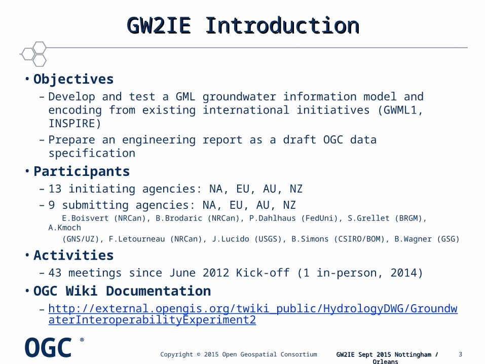
GW2IE IntroductionGW2IE Introduction
• Objectives– Develop and test a GML groundwater information model and
encoding from existing international initiatives (GWML1, INSPIRE)– Prepare an engineering report as a draft OGC data specification
• Participants– 13 initiating agencies: NA, EU, AU, NZ– 9 submitting agencies: NA, EU, AU, NZ E.Boisvert (NRCan), B.Brodaric (NRCan), P.Dahlhaus (FedUni), S.Grellet (BRGM), A.Kmoch
(GNS/UZ), F.Letourneau (NRCan), J.Lucido (USGS), B.Simons (CSIRO/BOM), B.Wagner (GSG)
• Activities– 43 meetings since June 2012 Kick-off (1 in-person, 2014)
• OGC Wiki Documentation– http://external.opengis.org/twiki_public/HydrologyDWG/Groundwater
InteroperabilityExperiment2
3Copyright © 2015 Open Geospatial Consortium

OGC®
GW2IE Sept 2015 Nottingham / Orleans GW2IE Sept 2015 Nottingham / Orleans
GW2IE Prior WorkGW2IE Prior Work
Pre-OGC TC Boulder (June 2015):•Conceptual Model: complete•Logical Model: complete•XML Examples: significant progress•Use-case Implementations: significant progress•Eng Report: significant progress
4Copyright © 2015 Open Geospatial Consortium

OGC®
GW2IE Sept 2015 Nottingham / Orleans GW2IE Sept 2015 Nottingham / Orleans
GW2IE Recent ProgressGW2IE Recent Progress
Post-OGC TC Boulder (June 2015):•XML Examples: complete
– Full examples: see GWML2 SVN (https://xp-dev.com/svn/gwml2/Documents/instance/)– Fragments: see GW2IE report
•Use-case Implementations: complete– Five use-cases: successful– Nine agencies: NA, EU, AU, NZ– 14 web services: WMS, WFS, SOS, WPS– 17 change requests
•Eng Report: complete – Release to OGC Portal (01 Sept 2015, OGC 15-082, 175 pp)– Draft GWML2 specification + implementation report– Public release pending approval by HDWG & OGC (under review)
5Copyright © 2015 Open Geospatial Consortium

OGC®
GW2IE Sept 2015 Nottingham / Orleans GW2IE Sept 2015 Nottingham / Orleans
GW2IE Next StepsGW2IE Next Steps
• GW2IE Eng Report public release– HDWG: vote at 2015 Annual Workshop (Orleans, 20-23 Sept 2015)– OGC TC: electronic vote of OGC TC following HDWG acceptance– OGC TC: public release via OGC Portal
• Groundwater SWG (GWML2) initiate– HDWG: vote at HDWG session at OGC TC (Nottingham)– OGC TC: request SWG initiation at OGC TC Plenary (Nottingham)– HDWG: develop charter at 2015 Annual Workshop (Orleans)– OGC TC: 3 month public comment then HDWG / OGC approval
vote
6Copyright © 2015 Open Geospatial Consortium

OGC®
GW2IE Sept 2015 Nottingham / Orleans GW2IE Sept 2015 Nottingham / Orleans
• Discussion
• Vote to initiate SWG
GW2IE Wrap-upGW2IE Wrap-up
7Copyright © 2015 Open Geospatial Consortium

OGC®
GW2IE Sept 2015 Nottingham / Orleans GW2IE Sept 2015 Nottingham / Orleans
GW2IE Use CasesGW2IE Use Cases
• Five use cases to guide GWML2 design and testing– Commercial - find water wells, estimate cost of water supply well
http://external.opengis.org/twiki_public/HydrologyDWG/UseCase1
– Policy - meet EU Water Framework Directive requirementshttp://external.opengis.org/twiki_public/HydrologyDWG/UseCase2
– Environmental - assess risks to gw dependent ecosystemshttp://external.opengis.org/twiki_public/HydrologyDWG/UseCase3
– Scientific - determine flow of groundwater via gw modeling http://external.opengis.org/twiki_public/HydrologyDWG/UseCase4
– Technologic – map GWML2 to existing info modelshttp://external.opengis.org/twiki_public/HydrologyDWG/UseCase5
8Copyright © 2015 Open Geospatial Consortium
OGC®
GW2IE Sept 2015 Nottingham / Orleans GW2IE Sept 2015 Nottingham / Orleans
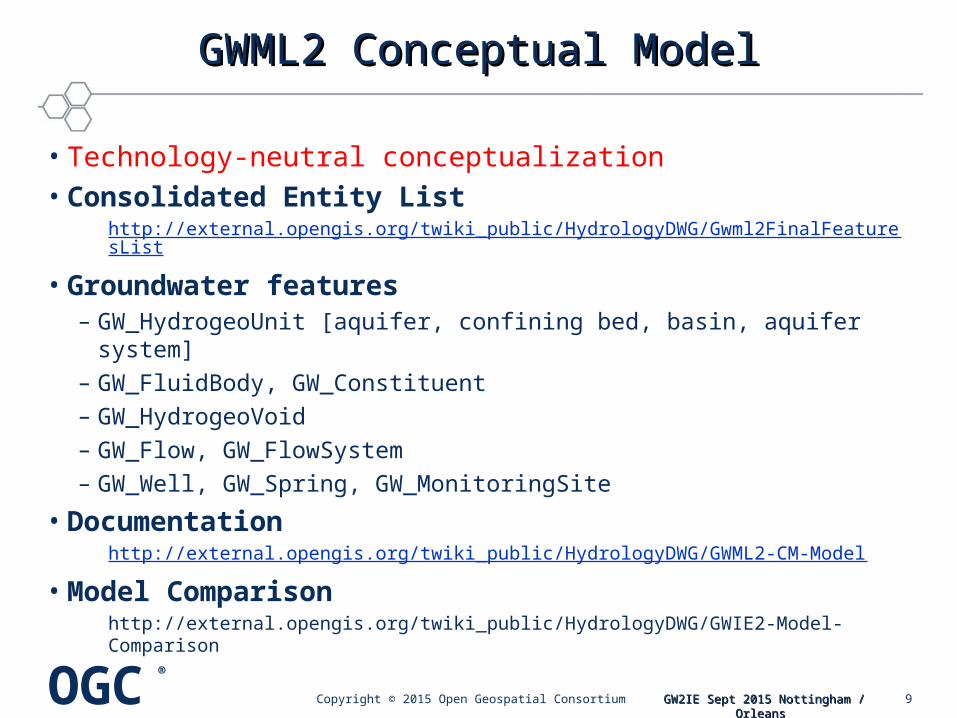
GWML2 Conceptual ModelGWML2 Conceptual Model
• Technology-neutral conceptualization• Consolidated Entity List
http://external.opengis.org/twiki_public/HydrologyDWG/Gwml2FinalFeaturesList
• Groundwater features– GW_HydrogeoUnit [aquifer, confining bed, basin, aquifer system]– GW_FluidBody, GW_Constituent– GW_HydrogeoVoid– GW_Flow, GW_FlowSystem– GW_Well, GW_Spring, GW_MonitoringSite
• Documentationhttp://external.opengis.org/twiki_public/HydrologyDWG/GWML2-CM-Model
• Model Comparisonhttp://external.opengis.org/twiki_public/HydrologyDWG/GWIE2-Model-Comparison
9Copyright © 2015 Open Geospatial Consortium
OGC®
GW2IE Sept 2015 Nottingham / Orleans GW2IE Sept 2015 Nottingham / Orleans
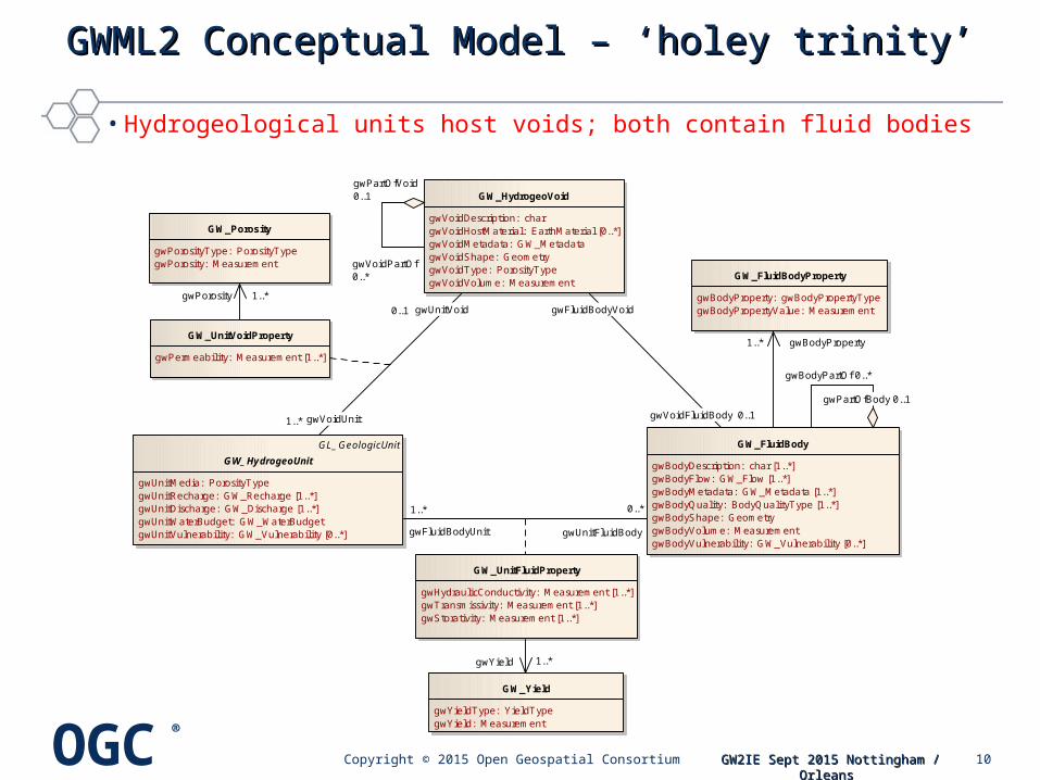
GWML2 Conceptual Model – ‘holey trinity’GWML2 Conceptual Model – ‘holey trinity’
GL_GeologicUnit
GW_HydrogeoUnit
gwUnitMedia: PorosityTypegwUnitRecharge: GW_Recharge [1..*]gwUnitDischarge: GW_Discharge [1..*]gwUnitWaterBudget: GW_WaterBudgetgwUnitVulnerability: GW_Vulnerability [0..*]
GW_UnitFluidProperty
gwHydraulicConductivity: Measurement [1..*]gwTransmissivity: Measurement [1..*]gwStorativity: Measurement [1..*]
GW_FluidBody
gwBodyDescription: char [1..*]gwBodyFlow: GW_Flow [1..*]gwBodyMetadata: GW_Metadata [1..*]gwBodyQuality: BodyQualityType [1..*]gwBodyShape: GeometrygwBodyVolume: MeasurementgwBodyVulnerability: GW_Vulnerability [0..*]
GW_HydrogeoVoid
gwVoidDescription: chargwVoidHostMaterial: EarthMaterial [0..*]gwVoidMetadata: GW_MetadatagwVoidShape: GeometrygwVoidType: PorosityTypegwVoidVolume: Measurement
GW_FluidBodyProperty
gwBodyProperty: gwBodyPropertyTypegwBodyPropertyValue: Measurement
GW_Porosity
gwPorosityType: PorosityTypegwPorosity: Measurement
GW_Yield
gwYieldType: YieldTypegwYield: Measurement
GW_UnitVoidProperty
gwPermeability: Measurement [1..*]
gwYield 1..*
gwBodyProperty1..*
gwPartOfVoid0..1
gwVoidPartOf0..*
gwPorosity 1..*
gwFluidBodyVoid
gwVoidFluidBody 0..1
gwFluidBodyUnit
1..*
gwUnitFluidBody
0..*
gwVoidUnit1..*
gwUnitVoid0..1
gwPartOfBody 0..1
gwBodyPartOf 0..*
• Hydrogeological units host voids; both contain fluid bodies
10Copyright © 2015 Open Geospatial Consortium

OGC®
GW2IE Sept 2015 Nottingham / Orleans GW2IE Sept 2015 Nottingham / Orleans
GW2IEGW2IE Logical Model Logical Model
• GML, O&M (e.g. OM_Measurement), GeoSciML, WaterML• GML-UML representation of Conceptual model
• http://external.opengis.org/twiki_public/HydrologyDWG/GWML2-UML-Model
– 5 application schema (GWML2-Main, Well, WellConstruction, Flow, Constituent)
– External dependencies:• ISO19115, 19107, 19108, 19103, 19156, 19123, OGC SWE
– Extends: • Observations & Measurements (O&M), GeoSciML (v3.2), InterleavedCoverages
– Adapts:• GWML1 well construction
– Cardinalities all [0..x]
• Significant change request to O&M
11Copyright © 2015 Open Geospatial Consortium

OGC®
GW2IE Sept 2015 Nottingham / Orleans GW2IE Sept 2015 Nottingham / Orleans
GeologicUnit
«FeatureType»GW_HydrogeoUnit
«property, voidable»gwUnitDischarge: GW_Discharge [0..*]gwUnitMedia: PorosityTypeTerm [0..1]gwUnitRecharge: GW_Recharge [0..*]gwUnitWaterBudget: GW_WaterBudget [0..1]
«Property»gwUnitProperty: OM_Measurement [0..*]
«property»gwUnitVulnerability: OM_Observation [0..*]
«type»GW_UnitFluidProperty
«property, voidable»gwHydraulicConductivity: OM_Measurement [0..*]gwStorativity: OM_Measurement [0..*]gwTransmissivity: OM_Measurement [0..*]gwYield: OM_Measurement [0..*]
«FeatureType»GW_FluidBody
«property, voidable»gwBodyFlow: GW_Flow [0..*]gwBodyMetadata: MD_Metadata [0..*]gwBodyProperty: OM_Measurement [0..*]gwBodyQuality: BodyQualityTerm [0..*]gwBodyShape: GM_Object [0..1]gwBodyVolume: OM_Measurement [0..1]gwBodyVulnerability: OM_Observation [0..*]
«FeatureType»GW_HydrogeoVoid
«property, voidable»gwVoidHostMaterial: EarthMaterial [0..*]gwVoidMetadata: MD_Metadata [0..1]gwVoidShape: GM_Object [0..1]gwVoidType: PorosityTypeTerm [0..1]gwVoidVolume: OM_Measurement [0..1]
«type»GW_UnitVoidProperty
«property, voidable»gwPermeability: OM_Measurement [0..*]gwPorosity: OM_Measurement [0..*]
gwFluidBodyVoid«property»
0..1
gwVoidFluidBody«property» 0..1
gwPartOfBody«property» 0..1
gwBodyPartOf«property» 0..*
gwFluidBodyUnit«property»
0..*
gwUnitFluidBody«property»
0..*
gwPartOfVoid«property» 0..1
gwVoidPartOf«property» 0..*
gwVoidUnit«property» 0..*
gwUnitVoid«property»
0..1
GWML2 Logical Model – GML specificGWML2 Logical Model – GML specific
12Copyright © 2015 Open Geospatial Consortium

OGC®
GW2IE Sept 2015 Nottingham / Orleans GW2IE Sept 2015 Nottingham / Orleans
GWML2 GWML2 XML encodingXML encoding
• developed custom O&M and SWE patterns• O&M Pattern
– Most numeric values for subtypes and provenance (OM_Measurement*)
– Analytical results (waterbody constituents, aquifer properties)– Aquifer test (aquifer properties)
• SWE Data Record: lithology and stratigraphy log • http://external.opengis.org/twiki_public/HydrologyDWG/GwmlSweDataRecord
– Defined GWML2 data records for stratigraphy and lithology• Extend to other downhole logs (geophysical, geochemistry, geochronology)
– WFS coverages verbose, but explicit
13Copyright © 2015 Open Geospatial Consortium

OGC®
GW2IE Sept 2015 Nottingham / Orleans GW2IE Sept 2015 Nottingham / Orleans
GWML2 GWML2 XML encoding – Aquifer testXML encoding – Aquifer test
object Specification Diagrams
drawdown1: TimeseriesObservation
drawdown2: TimeseriesObservation
Transmissiv ity: OM_Observation
result = XXX
c1: ObservationContext
role = ../def/role/supportObservation
c2: ObservationContext
role = ../def/role/supportObservation
pumpTest: GW_AquiferTest
obs1: GW_Well
obs2: GW_Well
+relatedObservation
+relatedObservation
+relatedObservation
+featureOfInterest
+relatedObservation
+relatedObservation
+relatedObservation
+featureOfInterest
+featureOfInterest
Water Table
Pumping Bore
Observation Bore Observation Bore
+procedure
Water Table
Pumping Bore
Observation Bore Observation Bore
+procedure
14Copyright © 2015 Open Geospatial Consortium

OGC®
GW2IE Sept 2015 Nottingham / Orleans GW2IE Sept 2015 Nottingham / Orleans
GW2IE ImplementationGW2IE Implementation
• Successful test of GWML2• Use Case 1 (water wells, springs, aquifers)
– BRGM, CSIRO-BoM, FedUni, GNSS/UZ, NRCan, USGS (WFS, WMS)
• Use Case 2 (management area)– CSIRO-BoM, GNSS/UZ (WFS)
• Use Case 3 (groundwater body, flow, constituents)– FedUni, GNS/UZ (WFS, WMS, SOS)
• Use Case 4 (water wells, aquifers, flow, groundwater body)– GNSS/NZ, USGS (WFS, WMS, SOS, WPS)
• Use Case 5 (map: GWML1*, INSPIRE-Hydrogeology, HY_Features*)– BRGM, CSIRO, GSG, NRCan
– * designates incomplete mappingParticipants listed in alphabetical order
15Copyright © 2015 Open Geospatial Consortium

OGC®
GW2IE Sept 2015 Nottingham / Orleans GW2IE Sept 2015 Nottingham / Orleans
GW2IE Implementation – change requests (17)GW2IE Implementation – change requests (17)
16Copyright © 2015 Open Geospatial Consortium

OGC®
GW2IE Sept 2015 Nottingham / Orleans GW2IE Sept 2015 Nottingham / Orleans
GW2IE Eng ReportGW2IE Eng Report
• Draft GWML2 specification + Implementation report• Release to public SVN (non-advertised) and OGC Portal
http://xp-dev.com/svn/gwml2/Documents/GroundWaterML2_GW2IE-FinalReport.docx
• Includes– conceptual and logical models – GML/XML encoding rules & tests– example XML encodings– use-cases and implementation results– change requests (issues identified)
17Copyright © 2015 Open Geospatial Consortium
OGC®
GW2IE Sept 2015 Nottingham / Orleans GW2IE Sept 2015 Nottingham / Orleans
GW2IEGW2IE
• Discussion• Vote to recommend
public release of report
18Copyright © 2015 Open Geospatial Consortium