· . Re: ... mandatory constraints on project activities while guidelines, ... water quality; water...
140
August 15, 2014 Blue Mountains Plan Revision Team P.O. Box 907 Baker City, OR 97814 Electronically via www.fs.usda.gov/goto/BlueMountainForestPlanRevisionComments Re: Proposed Land Management Plans for the Blue Mountains and Draft Environment Impact Statement Dear Blue Mountains Plan Revision Team, On behalf of the undersigned organizations, I am submitting the attached comments on the Proposed Revised Land Management Plans for the Blue Mountains, Draft Environmental Impact Statement (DEIS), appendices, and associated documents. These organizations have a long history of participating in decisions concerning the management of Forest Service lands and represent members who use and enjoy the waters, public lands and natural resources in the Blue Mountains for recreational, scientific, spiritual, educational, aesthetic, and other purposes. Our members enjoy fishing, hiking, camping, hunting, bird watching, study, contemplation, photography and other activities in and around the waters and public lands in this area. While we understand and respect the amount of work that has gone into this process by the Forest Service, we believe the proposed land management plans and DEIS are in need of substantial revisions in order to: protect and restore the public resources that remain severely degraded by past management; to incorporate all the science generated by the ICBEMP process; to be consistent with applicable federal laws and regulations; to best achieve objectives consistent with the best available science; to meaningfully address new and emerging issues like global climate change; and to adequately address issues raised by these comments. Thank you for your careful consideration of these comments and recommendations to improve the planning directives. We appreciate the opportunity to comment on the proposal and look forward to working with the Forest Service as you address the issues we have identified. Sincerely, Veronica Warnock Conservation Director Hells Canyon Preservation Council P.O. Box 2768 La Grande, OR 97850 541-963-3950 [email protected]
Transcript of · . Re: ... mandatory constraints on project activities while guidelines, ... water quality; water...
August 15, 2014 Blue Mountains Plan Revision Team P.O. Box 907 Baker City, OR 97814 Electronically via www.fs.usda.gov/goto/BlueMountainForestPlanRevisionComments
Re: Proposed Land Management Plans for the Blue Mountains and Draft
Environment Impact Statement Dear Blue Mountains Plan Revision Team, On behalf of the undersigned organizations, I am submitting the attached comments on the Proposed Revised Land Management Plans for the Blue Mountains, Draft Environmental Impact Statement (DEIS), appendices, and associated documents. These organizations have a long history of participating in decisions concerning the management of Forest Service lands and represent members who use and enjoy the waters, public lands and natural resources in the Blue Mountains for recreational, scientific, spiritual, educational, aesthetic, and other purposes. Our members enjoy fishing, hiking, camping, hunting, bird watching, study, contemplation, photography and other activities in and around the waters and public lands in this area. While we understand and respect the amount of work that has gone into this process by the Forest Service, we believe the proposed land management plans and DEIS are in need of substantial revisions in order to: protect and restore the public resources that remain severely degraded by past management; to incorporate all the science generated by the ICBEMP process; to be consistent with applicable federal laws and regulations; to best achieve objectives consistent with the best available science; to meaningfully address new and emerging issues like global climate change; and to adequately address issues raised by these comments. Thank you for your careful consideration of these comments and recommendations to improve the planning directives. We appreciate the opportunity to comment on the proposal and look forward to working with the Forest Service as you address the issues we have identified. Sincerely,
Veronica Warnock Conservation Director Hells Canyon Preservation Council P.O. Box 2768 La Grande, OR 97850 541-963-3950 [email protected]

On behalf on: Marlies Wierenga Pacific NW Conservation Manager WildEarth Guardians P.O. Box 42106 Portland, OR 97242 503-278-0669 [email protected] Doug Heiken Conservation and Restoration Coordinator Oregon Wild P.O. Box 11648 Eugene OR 97440 541-344-0675 [email protected] Mike Petersen Executive Director The Lands Council 25 W. Main Ave, Suite 222 Spokane, WA 99201 509-209-2406 [email protected] John Meyer Executive Director Cottonwood Environmental Law Center 24 South Willson Ave, Suites 6-7 Bozeman, MT 59715 406-587-5800 [email protected] Meriel Darzen Executive Committee - Juniper Group Oregon Chapter Sierra Club 725 NW Delaware Ave Bend, Oregon 97701 (978) 505-5693 [email protected]
Dave Willis, Chair Soda Mountain Wilderness Council P.O. Box 512 Ashland, OR 97520 541/482-8660 [email protected]
Greg Haller Conservation Director Pacific Rivers Council 317 SW Alder St Portland, OR 97204 (503) 228-3555 [email protected] Wendy McDermott Associate Director Washington Conservation Programs American Rivers 180 Nickerson St., Ste. 202 Seattle, WA 98109 206-213-0330 [email protected]

HCPC et al Proposed Revised LMP for the Blue Mountains/DEIS Comments Page 3 of 140
A. The proposed land management plans do not comply with the National Forest Management Act or the 1982 planning rule
The National Forest Management Act (NFMA) directs the Secretary of Agriculture to issue regulations “that set out the process for the development and revision of the land management plans, and the guidelines and standards prescribed by this subsection.” 16 U.S.C. § 1604(g. The Secretary “shall … incorporate the standards and guidelines required by this section in plans for units of the National Forest System…” Id. § 1604(c). In this case, the National Forests in the Blue Mountains have chosen to proceed under the 1982 planning regulations. The 1982 planning regulations implementing NFMA state, “[p]lans guide all natural resource management activities and establish management standards and guidelines for the National Forest System. They determine resource management practices, levels of resource production and management, and the availability and suitability of lands for resource management.” 36 C.F.R. § 219.1(b) (1982). Standards and guidelines in forest plans must be “qualitative and quantitative,” Id. at §219.1(b)(12), and forest plans must establish “standards and requirements by which planning and management activities will be monitored and evaluated.” Id. § 219.5(a)(7). As set forth below, in a number of respects, the draft plans do not meet the requirements of NFMA or the 1982 planning rule.
1. The proposed land management plans do not incorporate adequate standards
to protect wildlife diversity or watershed protection NFMA requires the incorporation of “standards and guidelines” into forest plans in order to “insure” that during management activities protection is provided for various resources such as wildlife diversity, soils, watershed conditions, and fish habitat. 16 U.S.C. §1604. Standards are mandatory constraints on project activities while guidelines, as historically applied by the Forest Service and interpreted by courts, are discretionary restrictions on project activities. Webster defines “insure” as “to make certain especially by taking necessary measures and precautions.” Since guidelines have not been interpreted as mandatory, standards are the only planning component that can adequately insure the protection mandated in NFMA. Other planning components such as desired conditions, goals, objectives and guidelines are important, but they cannot insure such protection because of the discretion they afford in implementation.
The 1982 planning regulations affirm this requirement to use standards to protect wildlife diversity, soils, watershed conditions, and fish habitat. The regulations require the establishment of quantitative and qualitative standards and guidelines in order to attain a plan’s stated goals and objectives. 36 C.F.R. § 219.1 to 219.3. The 1982 rule also requires forest plans to: protect streams, streambanks, shorelines, lakes, wetlands, and other bodies of water; provide for and maintain diversity of plant and animal communities; provide for adequate fish and wildlife habitat to maintain viable populations of existing native vertebrate species; include measures for preventing the destruction or adverse modification of critical habitat for threatened and endangered species; prohibit detrimental changes in water temperature or chemical composition, blockages of water courses, or deposits of sediment in areas which adversely affect water conditions or fish habitat. 36 C.F.R. § 219.27
HCPC et al Proposed Revised LMP for the Blue Mountains/DEIS Comments Page 4 of 140
While the Blue Mountains are working under the 1982 rule, it is also instructive to look at the updated planning rule, which was revised in order to better equip the Forest Service in meeting its goal “to sustain the health, diversity and productivity of the nation’s forest and grasslands”. The 2012 planning rule requires forest plans to include standards and guidelines to maintain or restore the ecological integrity of terrestrial and aquatic ecosystems and watersheds in the plan area, including their structure, function, composition, and connectivity. Such standards and guidelines must take into account: the interdependence of terrestrial and aquatic ecosystems; contributions of the plan area to ecological conditions within the broader landscape influenced by the plan area; system drivers, including dominant ecological processes, disturbance regimes, and stressors; and the ability of terrestrial and aquatic ecosystems in the plan area to adapt to change. Additionally, plans must include standards and guidelines to maintain or restore: air quality; soils and soil productivity; water quality; water resources; and the ecological integrity of riparian areas in the plan area. 36 C.F.R. § 219 (2012). Not only are standards required by NFMA and its implementing regulations, they are good practice as they promote accountability and planning efficiencies. Standards provide certainty about future management action. Without adequate standards, interpretation of the legal requirements and the forest plans desired conditions, goals, and objectives are left up to the line officers. It places line officers in the position of having to make politically contentious decisions without an adequate framework. Clear guidance, direction, and requirements will help them meet legal requirements and implement best available science as they manage national forests and provide the public with assurance that forest management will not cross certain unacceptable thresholds. Minimum requirements and actions are not inconsistent with the discretion afforded in NFMA and the 1982 regulations; they merely place floors and sideboards on that discretion and channel it in the right direction. In addition, standards facilitate planning efficiencies at the project level by eliminating the need for planning teams to negotiate and write project specific standards for each management action; a time consuming and inefficient use of limited Forest Service resources. See Nie et al, 2014.
Standards also lead to efficiencies in the context of the Endangered Species Act (ESA). One of the five factors considered by the wildlife regulatory agencies in making listing decisions is “the inadequacy of exiting regulatory mechanism[s].” 16 U.S.C. § 1533. Voluntary and unenforceable plan components such as desired conditions, goals, objectives, and guidelines are generally not considered a sufficient regulatory mechanism. Standards have been used to justify not listing a species while lack of standards has led to listing decisions. For example, the U.S. Fish and Wildlife Service did not list the Queen Charlotte goshawk in southeast Alaska due to the standards contained in the Tongass National Forest Plan. Conversely, the 2010 decision to list the greater sage grouse as “warranted but precluded” was influenced by the lack of protection in National Forest plans with sagebrush habitat significant to the species.
The Preferred Alternative/Proposed Revised Land Management Plan for the Blue Mountains fails to comply with NFMA’s requirement to incorporate standards into forest plans in order to protect the valuable ecological resources identified by the Act. It contains only minimal standards and guidelines and contains no standards for the protection of: soils, water quality, and watershed condition; streams, stream banks, shorelines, lakes, wetlands, and other bodies of water; critical habitat for threatened and endangered species; fish and wildlife habitat necessary

HCPC et al Proposed Revised LMP for the Blue Mountains/DEIS Comments Page 5 of 140
for maintaining viable populations of native species; or, old growth forests or old growth trees that many species depend on.
For the above reasons, during scoping we asked that detailed standards and guidelines be developed. We pointed out that the proposed action did not contain adequate standards and guidelines to protect wildlife diversity or watershed condition as required by NFMA and its implementing regulations. We provided the best available science for use in drafting the requested management direction. No action alternative developed contains the standards necessary to insure the protection of wildlife diversity, soils, watershed conditions, and fish habitat. Alternative C does contain a limited amount of additional standards and guidelines, but for most issue areas the action alternatives share the same management direction (for example, the standards and guidelines that apply to Riparian Management Areas are identical across all action alternatives). Standards and guidelines that meet the requirements of NFMA and the 1982 planning regulations must be developed and incorporated into the proposed action.
2. The proposed land management plans do not insure the diversity or viability of aquatic or terrestrial wildlife species in the Blue Mountains
According to the DEIS, the national forests in the Blue Mountains “provide habitat for more than 250 native wildlife species, including larger species, such as cougar, black bear, mountain goat, bighorn sheep, deer, pronghorn antelope, gray wolf, and elk, along with a host of smaller birds and animals, such as marten, mink, beaver, badger, bobcat, coyote, river otter, Clark’s nutcracker, ruffed and blue grouse, and turkey. The area provides an important wildlife corridor connecting habitats and animal migration routes between the Rocky Mountains and central Oregon.” Proposed Revised Land Management Plan for the Blue Mountains National Forests p. 13. National Forest System lands in the Blue Mountains also play an important role in supporting the population viability of a variety of fish and other aquatic species. More than 30 native and 24 nonnative fish species occur within the Blue Mountains national forests and include endangered populations of Columbia River Basin Bull trout, Middle Columbia River Steelhead, Snake River Basin Steelhead, Snake River Basin Fall Chinook salmon, Snake River Basin Sockeye salmon, and Snake River Basin Spring Chinook salmon. The Imnaha and Grande Ronde river drainages provide the highest upstream spawning areas for Chinook salmon and steelhead trout on the Snake River in Oregon. The John Day River is the second longest undammed river (280 miles) in the contiguous United States and supports four different species of naturally reproducing native salmonids. Id.
NFMA requires the Forest Service to ‘‘provide for a diversity of plant and animal communities” across Forest Service lands. 16 U.S.C. § 1604(g)(3)(B). Regulations implementing this requirement direct the Service to manage forests for viable populations of native vertebrate and desired non-native species. 36 C.F.R. § 219.19 (1982). The regulations define viable populations as a population that has “the estimated numbers and distribution of reproductive individuals to insure its continued existence is well distributed in the planning area”. Id.
To insure viable populations are maintained, the 1982 regulations also require that the Forest Service identify management indicator species (MIS) and that “[p]opulation trends of the management indicator species will be monitored and relationships to habitat change determined.”
HCPC et al Proposed Revised LMP for the Blue Mountains/DEIS Comments Page 6 of 140
36 C.F.R. § 219.19(a)(6)(1982). This monitoring is “essential to verify and, if necessary, modify the forest plan's assumptions about the effects of timber harvesting and other management activities on wildlife…In order to meet the monitoring requirement, planners will need to obtain adequate inventories of wildlife populations and distribution.” Wilkinson, 1987.
The DEIS makes several general overriding assumptions throughout the assessment on terrestrial species viability. The main assumption made is that “managing for the historical range of variability across ecosystems will result in maintaining viability for most species. Therefore, if management activities can produce conditions close to or within HRV, species that are adapted to these conditions will have a stronger likelihood of persistence.” DEIS Vol 2 p. 186. This assumption is fundamentally flawed. There is very little scientific evidence to suggest maintaining the diversity and integrity of a combination of habitat types will maintain viable populations of existing native and desired non-native vertebrate species in the planning area. 36 C.F.R. § 219.19 (1982). In fact, the Committee of Scientists convened under NFMA stated, “habitat alone cannot be used to predict wildlife populations”. Committee of Scientists 1999, Chapter 3:19.38.
Instead, the science supports that some level of direct species-level assessment and monitoring is necessary in order to determine whether species viability is being maintained. Monitoring activities must be required to take place during the planning of site-specific projects and monitoring data must be used in the project design. Noon, 2003. Activities, such as logging, that manage for HRV create landscapes that are missing many of the elements that support viable wildlife populations. Typically, roads must be built to remove logs. This has no analog in natural disturbance processes and creates habitats fragmented by the unnatural disturbance of motorized vehicle travel. Logging does not adequately create snags or the down and dead wood needed by many species.
3. The proposed land management plans’ monitoring programs do not comply with the 1982 rule
To insure that the Forest Service meets the diversity and viability requirement, the 1982 regulations require monitoring "[a]t intervals established in the plan" to evaluate "how well objectives have been met and how closely management standards and guidelines have been applied," at which point "the interdisciplinary team shall recommend to the Forest Supervisor such changes in management direction, revisions, or amendments to the forest plan as are deemed necessary." See 36 CFR 219.12(k). Monitoring requirements identified in the forest plan shall provide for "a quantitative estimate of performance comparing outputs and services with those projected by the forest plan and "[d]ocumentation of the measured prescriptions and effects, including significant changes in productivity of the land." Id. The 1982 regulations also direct the Forest Service to identify "management indicator species" ("MIS") whose population changes "are believed to indicate the effects of management activities." Id. § 219.19(a)(1). The 1982 regulations require that "population trends of the management indicator species will be monitored and relationships to habitat changes determined." Id. § 219.19(a)(6). The 1982 regulations further provide that, in the development of forest plans, proposed forest plans and forest plan alternatives must establish "objectives" for
HCPC et al Proposed Revised LMP for the Blue Mountains/DEIS Comments Page 7 of 140
the maintenance and improvement of habitat for MIS; prescribe measures to mitigate adverse impacts on MIS; and state and evaluate planning alternatives in terms of the amount and quality of habitat and of population trends of MIS. Id. § 219.19(a)(1)‐(7). The Forest Service is not meeting these statutory and regulatory requirements in the proposed forest plans.
a. Monitoring for Management Indicator Species NFMA requires forests to select Management Indicator Species (MIS) and adopt monitoring protocol in order to have a way to measure the effects of management activities on fish and wildlife populations. NFMA clearly directs the Forest Service to create regulations to “ensure research on and (based on continuous monitoring and assessment in the field) evaluation of the effects of each management system to the end that it will not produce substantial and permanent impairment of the productivity of the land.” 16 U.S.C. § 1604(g)(3)(C); Sierra Club v. Martin, 168 F.3d 1 (11th Cir. 1999). The Ninth Circuit has stated that the duty to ensure viable or self-sustaining populations “applies with special force to “sensitive” species.” Inland Empire Public Lands Council v. United States Forest Serv., 88 F.3d 754 (9th Cir. 1996) citing Oregon Natural Resources Council v. Lowe, 836 F.Supp 727, 733 (D.Or. 1993). In light of this direction, NFMA’s regulations require inventorying and monitoring on the National Forests under 36 C.F.R. §§ 219.12(d) and (k) as well as 36 C.F.R. §§ 219.19(a)(6), 219.26, and 219.19(a)(2) (1982). The governing regulations state, “each Forest Supervisor shall obtain and keep current inventory data appropriate for planning and managing the resources under his or her administrative jurisdiction.” Id. § 219.12(d). The regulations further require that “at intervals established in the plan, implementation shall be evaluated on a sample basis to determine how well objectives have been met and how closely management standards and guidelines have been applied.” Id. § 219.12(k). To insure biological diversity, the regulations specifically require that “[i]nventories shall include quantitative data making possible the evaluation of diversity in terms of its prior and present condition.” Id. § 219.26. Although NFMA clearly requires the monitoring of MIS populations, the Forest Service has traditionally relied upon the availability of suitable MIS habitat, rather than population surveys, to meet NFMA’s viable populations requirement. Inland Empire Public Lands Council v. United States Forest Serv., 88 F.3d 754 (9th Cir. 1996). However, in 2002 the Ninth Circuit revisited its holding in Inland Empire, and held that if the Forest Service utilizes a “proxy-on-proxy” approach to meeting the agency’s NFMA obligations, any habitat models must be grounded in fact and field verified. Idaho Sporting Congress v. Rittenhouse, 2002 U.S. App. LEXIS 19108 (9th Cir. 2002). The court also acknowledged that other courts have expressly disavowed the holding in Inland Empire, casting additional doubt on the validity of that case. See generally, Sierra Club v. Martin, 168 F.3d 1 (11th Cir. 1999), Utah Environmental Congress v. Zieroth, 190 F. Supp. 2d 1265, 1272 (D. Utah 2002) (holding that § 219.19 unambiguously requires collection of population data), Forest Guardians v. U.S. Forest Service, 180 F. Supp. 2d 1273 (D.N.M. 2001) (same). Given this developing reinterpretation of the legal requirements attendant to management indicator species, it is clear that the multiple mandates in NFMA and its implementing regulations requiring population monitoring and surveying must be incorporated in the revised

HCPC et al Proposed Revised LMP for the Blue Mountains/DEIS Comments Page 8 of 140
land management plans for the Malheur, Umatilla and Wallowa-Whitman National Forests. Unlike managing towards HRV, monitoring MIS species is a scientifically defensible means of maintaining viable populations throughout the Blue Mountains. In particular, the revised land management plans must address past and ongoing cumulative effects to a number of terrestrial avian, and aquatic MIS, listed species, and regional species of concern. It is important that the revised land management plans provide for accurate verifiable monitoring data that would inform whether the cumulative effects of past, present, and future management might be pushing certain species of concern, listed species, and/or indicator species toward a threshold of concern for population viability.
b. Monitoring for impacts to water quality Forests are essential for clean water and the Forest Service has a responsibility to protect water resources within National Forests. The DEIS’ monitoring plan for evaluating impacts to water quality consists of a serious of broad questions that ask about the status and trend of water quality, stream temperature, streamflow, and watershed conditions. This is insufficient. More information on how this monitoring will be conducted, implemented, and evaluated must be included in the plans in order to meet the 1982 Forest Rule requirements. See 36 CFR 219.12(k). In the plans as drafted, there is no way to understand how these requirements will lead to a cause and effect adaptive management program that will ensure the avoidance of significant adverse effects to water quality. The adopted forest plans must include an aquatic monitoring strategy that demonstrates short and long-term condition of aquatic systems. The indicators should be such that they can discern whether goals and standards are being met.
4. The selected alternative must include a broader range of management indicator species
In order to “estimate the effects of each alternative on fish and wildlife populations”, the Forest Service must identify “management indicator species” (MIS) within a forest management plan, and monitor their population trends. 36 C.F.R. § 219.19(a) (1982). The Forest Service must not only identify relevant vertebrate and invertebrate species for use as MIS, it must also state the reasons for their selection. Id. at §219.19(a) (1). The 1982 regulations further provide the following characteristics that should be considered when identifying MIS:
In the selection of management indicator species, the following categories shall be represented where appropriate: Endangered and threatened plant and animal species identified on State and Federal lists for the planning area; species with special habitat needs that may be influenced significantly by planned management programs; species commonly hunted, fished, or trapped; non-game species of special interest; and additional plant or animal species selected because population changes are believed to indicate the effects of management activities on other species of selected major biological communities or on water quality. On the basis of available scientific information, the interdisciplinary team shall estimate the effects of changes in vegetation type, timber age classes, community composition, rotation age, and year-long suitability of habitat related to mobility of management indicator species. Where appropriate, measures to mitigate adverse effects shall be prescribed.

HCPC et al Proposed Revised LMP for the Blue Mountains/DEIS Comments Page 9 of 140
Id. The draft plans propose only three MIS species for each national forest. Pileated woodpecker, while-headed woodpecker, and Rocky Mountain elk for the Umatilla and Wallowa-Whitman National Forests and Pileated woodpecker, white-headed woodpecker, and Mule deer for the Malheur National Forest. In making these selections, the plans failed to choose a range of MIS that reflect rare, threatened and endangered species that are most at risk, or species with special habitat needs and therefore cannot insure the viability of species as required by NFMA. Taken as a whole, the MIS selected for the draft plans do not present a strategy for ensuring viable wildlife populations are maintained in the Blue Mountains. As the DEIS discloses, both elk and Mule deer do not truly meet the criteria to fulfill the purpose of MIS. They are hunted species and changes in their population cannot be directly attributed to Forest Service management. Further, the MIS selected do not represent all of the major biological communities in the Blue Mountains. The three species identified for each forest do not provide an adequate picture of the effects of management on habitats in the Blue Mountains, particularly in a system that is rapidly changing due to climate change. The draft plans fail to identify MIS species for moist mixed conifer, riparian, aquatic, alpine, grasslands, and wetlands, among others. Overall, the draft plans identification of MIS are incomplete and inadequate to insure ecosystems and species are monitored at a level that will allow the Forest Service to understand trends in population and viability of the majority of species in the Blue Mountains. The 1982 regulations require the selection of MIS because their population changes are believed to indicate the effects of management activities on other species and on selected major biological communities, such as old growth. While we support the use of the three species currently identified as MIS for the three forests, more species must be added for the MIS to be effective and meet the requirements of NFMA. The three species identified in the DEIS for each forest would not provide an adequate picture of problems across the Blues, particularly in rapidly changing systems and those facing the greatest threat from climate change. The final plans should include all threatened and endangered species as MIS as well as other keystone, sensitive, and rare species including sage grouse, Flammulated owl, black backed woodpecker, American marten, and Northern goshawk, bull trout, salmon, and steelhead. MIS must also include representative species for dense forest condition (which could become rare under the plan), riparian areas, aquatic ecosystems and other habitats sensitive to management activities.
5. The final plans must incorporate science based standards to insure terrestrial wildlife species diversity and viability
Not only must the limited list of MIS species included in the draft plans be expanded, the final plans must include adequate standards to insure viable populations of the region’s wildlife. The draft forest plans fail to meet the NFMA mandate to provide for a diversity of plant and animal communities and fail to affirm the Forest Service’s commitment to the viability of all species. The final plans must be strengthened to affirm the Forest Service’s commitment to the

HCPC et al Proposed Revised LMP for the Blue Mountains/DEIS Comments Page 10 of 140
viability of all species in accordance with NFMA’s requirement and incorporate enforceable standards to insure species diversity and viability.
As discussed above, enforceable standards promote accountability and provide increased certainty about future management actions. Standards provide specific language for providing appropriate ecological conditions for species analyzed in the planning process. Without standards pertaining to species viability, there are no constraints on management activities that will insure viable populations of species are maintained. With the exception of bighorn sheep, the proposed forest plans provide very limited standards related to species viability; in fact, there are only three. WLD-HAB-6: S-1 Standard. Activities that have potential to cause abandonment or destruction of known denning, nesting, or roosting sites of threatened, endangered, or sensitive species shall not be authorized or allowed within 1,200 feet of those sites. WLD-HAB-12: S-7 Standard. Where mechanical treatment activities occur within dry or cool moist forest habitat, all snags 21 inches d.b.h. and greater and 50 percent of the snags from 12 to 21 inches d.b.h. shall be retained, except for the removal of danger/hazard trees. Snags shall be retained in patches. WLD-HAB-20:G-5 Standard. Salvage logging shall not occur within burned source habitat areas less than 100 acres, except for the removal of danger/hazard trees. The above standards are grossly insufficient to protect the broad array of wildlife species that occur in the Blue Mountains and must be expanded in the final plans. Bighorn Sheep: To insure long-term self-sustaining viable bighorn sheep populations, the adopted revised land management plans must go beyond protection of existing remnant population levels. The plans’ goal must be to recover bighorn populations beyond current population levels and allow for bighorn sheep expansion into new habitats. We support the population recovery goal of 2,000 bighorn sheep identified by the Hells Canyon Initiative. We applaud the use of a science based risk assessment/the Payette methodology in the proposed revised land management plans. The Payette’s decision to reduce domestic sheep grazing in order to maintain habitat for bighorn sheep was a science-based decision that used peer reviewed literature and data gathered from bighorn sheep populations affected by the decision. However, the proposed land management plans must be further strengthened if bighorn sheep are to maintain viable populations throughout their range. The NFMA regulations state that "in forest planning, . . . lands suitable for grazing shall be identified . . . [based on] an analysis of the economic and environmental consequences and the alternatives uses forgone." 36 C.F.R. § 219. The DEIS needs to provide a suitability analysis that documents the fact that the consequences of sheep grazing in bighorn habitat results in lots of dead bighorns, and it must document the fact that where domestic sheep are allowed to graze the alternative use forgone is sustainable populations of native bighorns.
HCPC et al Proposed Revised LMP for the Blue Mountains/DEIS Comments Page 11 of 140
Specifically, the selected alternative should identify and map habitat that is determined as unsuitable for domestic sheep grazing. Areas that are currently occupied by bighorn sheep, and areas where bighorn sheep are likely to expand, are not suitable for domestic sheep grazing. Land Managers need this tool when making decisions related to restocking or converting allotments. Currently unoccupied bighorn sheep habitat should be classified as unsuitable for domestic sheep grazing in the selected alternative. Such a classification will insure allotments are not converted or reopened to domestic sheep precluding recovery options for wild sheep. Bighorn sheep should be listed as a MIS species in the selected alternative. Bighorn sheep habitat degradation, including spread of noxious weeds and damage from livestock grazing, must be addressed and analyzed in the Final EIS. We also request that the Final EIS include an economic impact study of a recovered bighorn sheep population to surrounding rural economies and the larger geographic region. The Idaho Wild Sheep Foundation raised $86,115 for its 2014 raffle of a ram tag in Hells Canyon; the Colorado bighorn sheep tag sold for $130,000 at auction, and the raffle held in addition to the auction brought $78,200; and a new raffle system for 10 bighorn sheep tags launched by the Wyoming Game and Fish Department this year has generated more than $665,000, thus far. These economic benefits must be compared to those of the domestic sheep industry. In addition to the above recommendations, in order to maintain viability populations of bighorn sheep, the standards and guidelines for Range Management and Domestic Livestock Grazing included in the Preferred Alternative must be expanded and clarified. Specifically, the following clarifications and changes must be made in Final EIS: (italics are used for additions. Strikethroughs are used to delete a word. Bulleted points are additional comments.) RNG-9: S-2 Standard. Domestic sheep or goat grazing shall not be authorized or allowed on lands where effective separation from bighorn sheep cannot be reasonably maintained.
• This standard does not define what “effective separation” between domestic and bighorn sheep means. It must clarify in the standard itself or in the glossary that in determining “effective separation” a quantitative risk assessment, such as the one referenced in the August 19, 2011 USFS Washington Office Directive from the Deputy Chief, National Forest System, must be used. A qualitative assessment is insufficient in maintaining separation.
RNG-10: S-3 Standard. The use of domestic goats or sheep for manipulation of vegetation (i.e., noxious weed control, fuels reduction) shall not be authorized or allowed within or adjacent to source habitat for bighorn sheep.
• “Source habitat” must be defined in the forest plan glossary.
RNG-11: S-4 Standard. The use of recreational pack goats shall not be authorized or allowed within or adjacent to source habitat for bighorn sheep.
• “Adjacent” needs to be defined. The standard must use the best available science to
specify what size buffer is needed in order to maintain separation. Buffer zones are

HCPC et al Proposed Revised LMP for the Blue Mountains/DEIS Comments Page 12 of 140
frequently cited as needing to be a minimum of 9 airline miles/13.5 km between domestic sheep and goats and wild sheep. However, in contiguous wild sheep habitat where movement by wild sheep have the potential to cover large distances, larger buffer zones may be needed. Wild Sheep Working Group. 2012. Recommendations for Domestic Sheep and Goat Management in Wild Sheep Habitat. Western Association of Fish and Wildlife Agencies.
• The public must be notified of this restriction through signs placed at trailheads and through the use of a free use permit/registration system requiring activities that minimize risk and control of pack goats at all times (such as high-lining or tethering at night). This would be a cost effective way to make pack goat users implement good practices and make them aware of the risks to bighorn sheep. If such a system is not put in place, pack goats should be banned.
• This standard should be expanded or a new standard drafted requiring any contact between recreational pack goats and bighorn sheep be reported.
RNG-12 Standard. An effective monitoring program shall be in place to detect presence of bighorn sheep in identified high-risk areas when authorized domestic sheep or goats are present on adjacent or nearby allotments. When effective monitoring has not been conducted for bighorn sheep presence, domestic sheep or goat grazing shall not be authorized.
• What “effective monitoring” is must be defined in the standard or glossary. Effective Monitoring should include the use of fly-overs as the most effective way to monitor.
• The standard must require that monitoring occur prior to the turn out date. Waiting until the last minute/day before turn out is not enough. The monitoring timeframe should be based on weather and terrain.
• The Forest Service should coordinate with state agencies on monitoring, sharing data.
• High-risk areas identified should be modeled and mapped as part of the forest plan revision process and incorporated into the final forest plans.
• Monitoring actions must include monitoring for domestic strays. If monitoring does not pick up strays, it is not effective.
RNG-13 Guideline. Standard. Trailing of domestic sheep or goats should shall not be authorized or allowed within 7 9 miles of bighorn sheep home ranges. During trailing activities, the permittee and the forest service will conduct compliance monitoring to minimize domestic straying.
• Trailing generally results in domestic straying. Changing from a guideline to a standard (as analyzed in Alternative C) and requiring compliance monitoring will minimize strays.
• The separation distance must be justified by science and other relevant information. The selected distance must insure that bighorn sheep have minimal risk of contact with domestic sheep. The literature supports a greater distance. If the required separation distance cannot be obtained, then trucking must be used rather than trailing.
HCPC et al Proposed Revised LMP for the Blue Mountains/DEIS Comments Page 13 of 140
RNG-14 Standard. When effective monitoring has not been conducted for bighorn sheep presence, domestic sheep or goat grazing shall not be authorized.
• This standard should be a part of RNG-12; see comments for RNG-12 RNG-15 Standard. Permitted domestic sheep and goats shall be counted onto and off of the allotment by the permittee using pit tags and an automatic counter. A reasonable effort to account for the disposition of any missing sheep must be made by the permittee.
• This standard must be expanded to define what a reasonable disposition of missing sheep means. The most effective method would be a fly-over.
• The permittee should be required to develop a written agreement with relevant federal and state wildlife and agricultural agencies that addresses the retrieval and disposition of stray domestic sheep on public lands. Timeliness of responding to stray domestics in rugged landscapes continues to be an issue. Written clearance from the livestock owner that allows USDA Wildlife Services, ODFW, WDFW, or relevant state department of agriculture to remove strays immediately would address this issue. The standard must state what will happen to the missing sheep if found. The permittee should be required to coordinate with the relevant state department of agriculture to deal with the missing sheep--they are the state agency with authority over domestic livestock.
RNG-16 Standard. When permitted sheep are found to be missing, the Forest Service, U.S. Fish and Wildlife Service and Oregon Department of Agriculture shall be notified within 24 hours.
• The Forest Service has to authority to dispose of domestic livestock. The permittee should also be required to notify the agencies with authority to take action and implement the agreement discussed above.
RNG-17 Standard. Authorized domestic sheep or goats shall be individually marked in a manner that allows immediate identification of ownership at a distance during the grazing season at all times while on NFS lands.
• Including this standard in the adopted forest plans is essential to managing viable populations of bighorn sheep across NFS lands in the Blue Mountains. If a sheep is found off allotment it is essential that the responsible permittee can be identified.
RNG-18 Standard. Emergency Action Plans must be developed for any domestic sheep or goat allotment adjacent to source habitat or core herd home ranges. Implement emergency actions Emergency Action Plan shall be implemented when bighorn sheep presence is detected within 7 9 miles of active domestic sheep or goat grazing or trailing. Actions to be taken shall insure separation between bighorn sheep and domestic sheep or goats.
• The separation distance must be based on the best available science and other relevant information; see comments to RNG-13.
• An emergency action plan must be part of any EA developed for domestic sheep/goat allotment adjacent to source habitat/core home ranges. This emergency action plan must

HCPC et al Proposed Revised LMP for the Blue Mountains/DEIS Comments Page 14 of 140
be incorporated into Annual Operating Instructions (AOI) for grazing allotments and trailing permits.
RNG-19 Guideline. To maintain separation, when bighorn sheep are found within 7 9 miles of an active domestic sheep and goat allotment, implementation of emergency actions for domestic sheep and goat grazing could include: will make every effort to: Reroute (move) domestic sheep or goats to a new routing path that will take them away from the likely bighorn movement; this may involve rerouting within the permitted allotment, movement to a different allotment, or, if the situation cannot otherwise be resolved, moving the permitted sheep off of the national forest until the situation can be resolved. Inform the appropriate state agency of the bighorn sheep location.
• Actions that reroute or move domestics should be considered prior to a state agency taking action. It is Idaho policy and common practice in Oregon to remove a foraying bighorn sheep to manage transmission and spread of disease. Bighorn sheep should not be killed if it can be verified that they have not come into contact with domestic sheep and alternative actions can be taken to insure that separation is maintained.
Additionally, new standards should be drafted to address:
• The issue of diseased domestic sheep. The forest plans should contain a standard
requiring that sick or diseased animals on range be reported to land management or wildlife agency personnel as soon as possible after recognition; after that initial notification, inter-agency coordination should promptly occur.
• Stocking of allotments not currently under permit to domestic sheep and goats should
only be permitted after an adequate quantitative risk assessment has been completed and a de minimis risk of contact can be insured.
American Marten: Despite this species’ documented strongly declining trends and rarity across the forest, and regional habitat and population viability recovery goals, the proposed land management plans as drafted threaten the long-term viability of the American marten. The Preferred Alternative contains no standards or guidelines to protect the decadent closed canopy forest used by marten for denning and resting habitat. The DEIS does not adequately incorporate the relevant scientific recommendations, or sufficiently consider the overall cumulative management effects on American Marten or the related Pacific Fisher (the Pacific Fisher reportedly has habitat in the Washington portions of the Umatilla National Forest and historic habitat reported in old records throughout the region). Recent scientific research confirms that old forest dependent wildlife species are well adapted to the cyclic natural disturbance changes in the region’s fire ecology and the forests ever changing mosaic patterns. Research has also documented that martens, fishers, and other forest-dependent species are not adapted to logging and road disturbance. These management actions can act to extirpate and harm marten populations and habitat. Under NFMA and the 1982 planning rule, the

HCPC et al Proposed Revised LMP for the Blue Mountains/DEIS Comments Page 15 of 140
Forest Service has an obligation to insure viable populations of American marten and incorporate adequate standards and guidelines into the adopted revised land management plans for the Blue Mountains. While the standards included in Alternative C go a long way in protecting the late old structure stands within the moist and cold old forest types and snag structures that American marten depend on, they do not address the impacts of livestock grazing on marten, maintaining needed understory cover, or the snag and down woody debris requirements. We request that the Selected Alternative incorporate the standards and guidelines for late old structure habitat contained in Alternative C and develop new standards that address the issue of impacts from livestock grazing, understory cover, and snag and down dead wood requirements. Bald Eagle: The proposed land management plans contain no standards or guidelines for the protection of Bald Eagles. For the Final EIS, the Forest Service must develop an effective range of standards and guidelines for this species based upon relevant scientific research that addresses the dynamic nature and extent of eagle territories. Pileated Woodpecker, Black-backed Woodpecker, White-headed woodpecker, Pygmy Nuthatch, and Other Cavity Excavators: There is scientific concern that the Blue Mountains forests do not currently support viable populations of Pileated, Black-backed, White-headed, Three-toed, Lewis’, Williamson’s sapsuckers, Pygmy and other nuthatches, woodpeckers and cavity excavators. Past management activities have removed the snags and down dead wood that these species depend on across forested habitats. The final plans must incorporate the best available science into standards and guidelines that protect the habitat types and features that these species depend on. Viability of Species Relying on Snag and Down Wood: The draft plans establish desired targets for snags and dead wood, but these targets are flawed in three ways: First, they are based on data related to unharvested forests. That data does not adequately represent post-disturbance landscapes that were an important part of the evolutionary history of the wildlife that depend on dead wood. Second, desired levels of dead wood were reduced to accommodate fuel hazard, without adequate regard for the adverse effect on species viability or any of the other ecological functions provided by dead wood. Third, to insure species viability, the desired conditions for snags and dead wood need to be based on DecAID 80 percent tolerance levels for the specific species that are most likely to be at risk from management activities. The DEIS does not adequately address the cumulative, long-term consequences of forest management on dead wood habitat. The DEIS fails to disclose the cumulative adverse effects of widespread, repeated, landscape-scale treatments for resilience and fuel reduction. The DEIS fails to show that the prescribed levels of dead wood will maintain viable populations of wildlife dependent on dead wood. The DEIS fails to consider alternative ranges of desired dead wood habitat levels. In particular, dead wood does not need to be harmonized with fuel reduction objectives except in the immediate vicinity (within 200 feet) of structures. Since most fires are weather driven, not fuel driven, the area outside of the structure ignition zone does not need to be significantly modified for fuel reduction objectives. The landscape outside of the structure ignition zone should be managed for habitat, water quality, carbon storage/climate mitigation,

HCPC et al Proposed Revised LMP for the Blue Mountains/DEIS Comments Page 16 of 140
recreation, natural disturbance regimes, etc. Another alternative is to manage unroaded areas (>1,000 acres) for snag recruitment. The draft plan admits that the shortage of large snags is compounded in roaded areas. One of the special qualities of unroaded areas is that they are more apt to contain natural levels of snags and dead wood. Viability of Northern Goshawk and Forest Raptors: The draft forest plans fail to accurately address and prevent adverse impacts to Northern goshawks, other forest raptors, owls and their associated prey species that utilize forests across the region as home territories for nesting, fledgling, and foraging. Species of concern include Sharp-shinned and Cooper’s Hawks; Bald and Golden Eagles; Peregrine Falcons; Merlins; Pygmy, Flammulated, Great-horned, and Great-gray owls; and others. Goshawks are associated with complex forest structure and depend on maintenance of dense forest conditions. The draft plan calls for widespread logging for resilience and fuel reduction and timber production, which will generally reduce forest density and structural complexity to the detriment of goshawks. Much of this habitat is already fragmented. The DEIS did not adequately disclose the cumulative adverse effects of a planned program of widespread, repeated, landscape-scale logging. The Forest Service did not consider alternatives that would maintain more dense forest cover for goshawks, and numerous other wildlife that depend on dense forest conditions. See Greenwald et al 2005 and Beier, et al 2012. Goshawk research also finds “the consistency of results demonstrates goshawk selection for late successional forest structures (e.g. high canopy closure, large tree for forest type, canopy layering, abundant course woody debris) when using areas within their studies home ranges.” Greenwald et al 2005. Further, the survival of goshawk young is of marginal or poor quality and goshawk have a significantly higher mortality rate when available nesting and fledging territory has been degraded and fragmented by logging. Crocker-Bedford, 1990. The final plans must incorporate management areas that protect goshawks’ habitat from further density reduction, structural complexity and fragmentation. Standards and guidelines for this species must accurately and effectively incorporate this and other relevant research, in particular conclusions that emphasize goshawk dependence upon unlogged old and mature forest habitat. Research has conclusively and repeatedly emphasized that goshawks select for intact old and mature forest territories and generally will avoid logged impacted areas, or structural stages that are not mature and old forest. Thus, management direction protecting old forest habitat is critical to maintaining species viability of goshawks and other raptors. Viability of Neotropical Migrant and Native Birds: Neo-tropical migrant and native forest-dependent birds are in serious decline due to the adverse cumulative impacts from over a century of commercial logging in Oregon, including: Pygmy nuthatch, Chipping sparrow, Fox sparrow, Brown creeper, Hermit thrush, Band-tailed pigeon, Rufous hummingbird, Olive-sided flycatcher, Winter wren, Song sparrow, Golden-crowned kinglet, Pine siskin, Solitary vireo, Willow flycatcher, Tree swallow, Red-eyed vireo, Yellow warbler, Yellow-breasted chat, and others. The draft forest plans fail to adequately address the current population trends of native forest dependent migrant and native avian species and would irreparably fragment the migratory bird habitat is left.
HCPC et al Proposed Revised LMP for the Blue Mountains/DEIS Comments Page 17 of 140
The final plans must incorporate scientific research relevant to protecting these sensitive bird species. Forest fragmentation, including loss of viable nesting habitat within central and eastern Oregon’s national forests, is considered to be a primary cause behind declines observed in many forest songbird species. Further loss or fragmentation of habitat could lead to a collapse of regional populations of some forest birds. Robinson et al. 1995. As landscapes become increasingly fragmented, regional declines of migrant populations may result. Id. In the Pacific Northwest, researchers have found that old growth forests and historic ecosystem processes (including wildfire) are integral to the survival of migratory birds. The past and continuing logging-oriented management of the forests of Oregon and Washington, which provide nesting and fledgling habitat for numerous migratory birds, has resulted in severe ongoing population declines in forest canopy-dependent migratory and native birds. Sharp, 1996. In August 1999, the U.S. Fish and Wildlife Service (FWS) outlined what it perceived to be the agency’s legal obligation in terms of migratory birds and management planning. FWS stated that agencies should take “an extremely cautious position with respect to the intentional take of migratory birds by federal agencies.” Letter from Acting Director, United States Fish and Wildlife Service, to Regional Directors, Regions 1–7 and Assistant Director, Refuges and Wildlife (August 17, 1999), 3. FWS also cautioned that “the Service should not assert in any communication or correspondence that federal agencies are not covered by the prohibitions of the MBTA [Migratory Bird Treaty Act].” Id. In July 2000, the Eighth Circuit Court of Appeals held that federal agencies are required to obtain a take permit from FWS prior to implementing any project that will result in take of migratory birds. Humane Soc’y of the United States v. Glickman, 217 F.3d 882 (8th Cir. 2000). Due to this litigation, the FWS is operating under the assumption that the Migratory Bird Treaty Act applies to the Forest Service and its activities. 16 U.S.C. § 703 et seq. The Act states that “it shall be unlawful at any time, by any means or in any manner, to pursue, hunt, take, capture, kill, attempt to take, capture, or kill . . . any migratory bird.” 16 U.S.C. § 703. Recent legal analysis confirms Forest Service’s obligation to actively prevent the take of migratory birds, or obtain a permit for incidental take of individual species. Kim. 2001. The draft plans fail to incorporate the protective standards necessary to comply with these obligations. The final plans must be revised to prevent harmful direct, indirect and cumulative impacts on neotropical migratory and native birds and comply with the requirements of the Migratory Bird Treaty Act and NFMA.
6. The proposed land management plans do not promote the recovery and conservation of federal and state listed threatened, endangered, sensitive, and proposed candidate species
NFMA and its implementing regulations prohibit the destruction or adverse modification of critical habitat for threatened and endangered species. 16 U.S.C. §1604; 36 C.F.R. § 219.27. Within the planning area, there are nine species (one mammal, two plants, one snail, and five fishes) listed under the Endangered Species Act by either the U.S. Fish and Wildlife Service or the National Marine Fisheries Service and other state listed species. A list of these species and

HCPC et al Proposed Revised LMP for the Blue Mountains/DEIS Comments Page 18 of 140
information regarding each species is included in the project record. LMP p. 30. The revised land management plan does not provide for the recovery and viability of listed species populations and their habitat. The selected alternative must promote the recovery and conservation of federal and state listed threatened, endangered, sensitive, and proposed candidate species. In doing so, habitats for federally listed species should be managed in accordance with draft and final conservation strategies and recovery plans.
7. Connectivity required for species viability must be protected and restored Most native wildlife species’ survival depends on movement – whether it be day-to-day movements, seasonal migration, gene flow, dispersal of offspring to new homes, recolonizing an area after a local extirpation, or the shift of a species’ geographic range in response to changing climate conditions. For most animals and plants, all of these types of movement require a well-connected natural landscape. There is abundant scientific evidence that loss of habitat connectivity has profound negative impacts on fish, wildlife and plant populations. Id. at 3 (citing Wilcove et al. 1998, Crooks and Sanjayan 2006). Alarmingly, habitat loss and fragmentation is a cause of decline for about 83% of U.S. species that are becoming more rare. Id. at 4 (citing NatureServe and TNC 2000). Climate change is accelerating and increasing connectivity is widely recognized as one of the best adaptation measures managers can take. This vital role that habitat connectivity plays in ensuring long-term species’ viability and the disastrous effects of habitat fragmentation has inspired a growing call to action. Federal agencies and state governments are increasingly recognizing the intrinsic value of ecological connectivity to species persistence, for economic sustainability and as a means of addressing the challenge of adapting to climate change. A primary example is the Western Governors’ Association’s (WGA) adoption of Policy Resolution 07-01 (adopted February 27, 2007), Protecting Wildlife Migration Corridors and Crucial Habitat in the West and preparation of the Wildlife Corridors Initiative (June 2008 report). Other examples include:
• US House Resolution 2454, Title IV, Subtitle E (Adapting to Climate Change), Section 481. National Wildlife Habitat and Corridors Information Program. Passed by US House of Representatives on 26 June 2009.
• Secretarial Order 3289, Department of Interior. Addressing the Impacts of Climate Change on America’s Water, Land, and Other Natural and Cultural Resources. 14 September 2009.
• U.S. Forest Service, Responding to Climate Change: Developing Integrated Plans for Landscape Conservation. As directed by Chief Tidwell’s Memo (File 1300) on November 20, 2009.
• U.S. Forest Service, Service Strategic Framework for Responding to Climate Change, 2008.
Despite the overwhelming science identifying connectivity as essential to species viability, the DEIS contains no scientifically-based strategy for maintaining habitat connectivity. In order to insure species viability is maintained throughout the Blue Mountains, the adopted forest plans must contain such strategies.

HCPC et al Proposed Revised LMP for the Blue Mountains/DEIS Comments Page 19 of 140
B. Restoring and maintaining watershed conditions
Water bodies are a vital part of forest systems. As the DEIS notes, particularly sensitive and ecologically important areas to aquatic systems are the riparian zones, headwater zones, and native fish refugia (existing or potential). In addition, we would add to this list, remarkable water features, which are areas with unique habitat driven by hydrology. These include, for example, wetlands and fens, and are areas that often provide habitat for unusual species or assemblages of species. Riparian areas are important habitats onto themselves, but also provide key functions for maintaining stream function, morphology, and health. Riparian areas provide the buffer between uplands and streams, attenuating overland water and sediment flow. They support vegetation that stabilizes channel banks, maintains connectivity between surface and ground water tables, shades the channel helping to maintain cool water temperatures, and provides coarse woody debris to stream channels. Headwaters areas make up the majority of stream miles in a watershed, and have the highest terrestrial/aquatic interface area. Because of the latter, they “feel” the upland uses more than downstream segments; because of the former, the cumulative impact of headwater land uses is “felt” by downstream reaches. Unfortunately, the streams in the Blue Mountains have suffered impacts for over 150 years from a variety of land uses, including mining, logging, livestock grazing, diversions, and trapping. Perhaps three of the most significant factors affecting stream health are the excessive road network throughout national forest land in the Blue Mountains, livestock grazing and the virtual extirpation of beavers, a species that has a fundamental role in maintaining aquatic habitat diversity and attenuating floods, and whose absence results in fundamental shifts in stream behavior and health. Undisturbed watersheds (pre-settlement) are characterized by hydrologic functions and geomorphic conditions that can absorb precipitation and convey it downstream while maintaining stream channel and bank integrity, and habitat quality across the landscape. Disturbances to vegetation, channelization, disruption of riparian areas, and roading have dramatically shifted the condition, diversity, and function of streams. Roads, in particular, have had a clear impact. Roads, when maintained, channelize water into structures, encouraging downcutting; when not maintained adequately, they are prone to failure and dump serious amounts of sediment into stream courses, which can have catastrophic consequences for fish and other aquatic species. See Endicott, 2008; Gucninski et al, 2000. The watershed and restoration desired future conditions for all action alternatives as outlined in the DEIS are comprehensive. Vol. 3 pp. 180-204. However, desired future conditions are only aspirational guidance. A fundamental tenet of developing an aquatic conservation strategy (See Northwest Forest Plan, Aquatic Conservation Strategy, B-9 to B-10) is to establish working goals and commit to meeting them. Therefore, if the forests in the Blue Mountains are to develop and implement a meaningful aquatic conservation strategy, the forest plans should establish the desired future conditions as objectives. Corresponding standards and guidelines must be drafted that guide management activities so they meet/do not impede the objectives. In doing so, the

HCPC et al Proposed Revised LMP for the Blue Mountains/DEIS Comments Page 20 of 140
agency should include all the RMOs in PACFISH & INFISH and look at the Aquatic Conservation Strategy objectives in the Northwest Forest Plan. For instance, it should include the unimpeded movement of water, and wood from uplands to the stream (e.g., no interception by roads and culverts), and the free movement of all types of organisms (and all life stages) upstream/downstream and upslope/downslope, as appropriate.
1. Aquatic species viability As discussed above, NFMA and its implementing regulations prescribe that the Forest Service provide for the viability of all plant and animal communities and requires the incorporation of standards and guidelines into forest plans in order to ensure protection species viability and habitat are protected. 16 U.S.C. §1604. Specifically, the 1982 regulations require forest plans to: protect streams, streambanks, shorelines, lakes, wetlands, and other bodies of water; provide for adequate fish and wildlife habitat to maintain viable populations of existing native vertebrate species; include measures for preventing the destruction or adverse modification of critical habitat for threatened and endangered species; prohibit detrimental changes in water temperature or chemical composition, blockages of water courses, or deposits of sediment in areas which adversely affect water conditions or fish habitat. 36 C.F.R. § 219.27 In the Blue Mountains, there are 17 salmonid populations that are currently extinct. In addition, the Snake River Chinook salmon and steelhead, the mid-Columbia Basin steelhead, and the Bull Trout are listed as threatened. In order to meet the statutory and regulatory requirement to provide for species viability in the Blue Mountains, the selected alternative must include a suite of standards and guidelines specific to aquatic species viability. The standards related to watersheds and water quality across all alternatives are inadequate to ensure forward progress toward achieving the watershed desired future conditions. We recommend you adopt, in the forest plan, the following standards that are grounded in widely accepted watershed science principles: protect riparian areas and headwater areas, minimize soil disturbance in watersheds and route density, and do not further degrade water quality in impaired reaches, drinking water or key watersheds. If adopted these standards will further compliance with the NFMA, the Endangered Species Act (ESA), and the Clean Water Act (CWA), and give the public confidence in the agency’s restoration intentions. Specifically, the final plans should include a standard that sets an upper limit for the density of motorized routes (roads and motorized trails) in key watersheds, headwater areas, and Riparian Management Areas (RMAs). Where the current density exceeds the threshold, the final plan should require an annual reduction in route density until the threshold is met. The scientific literature related to route densities in watersheds containing salmonids and bull trout points to an appropriate maximum density of around 1 mile/sq mile. See Carnefix and Frissell, 2001; McCaffery et al, 2007; Harr and Nichols, 1993. The final plan should include a standard that disallows ground disturbing activities within RMAs, unless the agency can demonstrate that such activities will improve riparian condition (e.g., stream restoration work). Further, the selected alternative must include aquatic species as MIS. None of the action alternatives analyzed include aquatic species in the Management Indicator Species (MIS) list.
HCPC et al Proposed Revised LMP for the Blue Mountains/DEIS Comments Page 21 of 140
This omission is inappropriate given the distressed nature and importance of the Blue Mountain aquatic systems to imperiled fish, and the clear statutory and regulatory duty to provide for species viability. The fact that the majority of ESA listed species across the Blues are associated with perennial streams and riparian habitat points to the need for more monitoring in these habitats, one aspect of which is the identification of MIS for aquatic and riparian ecosystems. The final plan should list at least one but preferably more fish species as MIS. In addition, the Forest Service should list at least one other riparian-dependent species as a MIS, considering amphibians and macroinvertebrates as possible candidates.
2. Riparian Management Area widths Tables A-37 through A-39 list the minimum Riparian Management Area (RMA) widths for the action alternatives. DEIS, Vol. 3, pp. 223-224. With the exception of Alternative C, we are concerned that the given widths intended to protect the riparian resource are too narrow, especially in the context of warming climates characterized by more frequent storms of greater intensities resulting in widening 100 year floodplains. We support Alternative C’s approach which would include a minimum RMA width of 300’ of all streams, lakes, natural ponds, acres and wetlands. Such an approach is strongly supported by the best available science and we request that it be adopted in the preferred alternative. Quigley and Arlbelbide, 1997, noted that smaller, non-fish bearing perennial and intermittent streams:
• Are more affected by sedimentation from sediment production accelerated by upslope activities than larger streams (pp.1365 to1366).
• Are a primary source of sediment supplied to fish bearing streams (p. 1366).
• Typically comprise the majority of the channel network and “...therefore strongly influence the input of materials to the rest of the channel system.” (p. 1366)
• Are, highly vulnerable to the impacts of upslope activities, because the likelihood for discernible instream effects increases with slope steepness and the erodibility of sideslopes (p. 1367); these smaller headwater streams tend to have steeper and more erodible sideslopes (p. 1371).
Quigley and Arlbelbide (1997) noted that 300-foot wide protection zones around headwater streams may not be adequate to prevent increased sediment delivery to streams in some areas. There is a greater than 25 percent probability of sediment delivery to streams on a 30 percent slope with a 100 foot wide fully functional RMA based on the analysis in Quigley and Arlbelbide (1997). For slopes of 50 percent abutting intermittent stream channels, the aquatic assessment in Quigley and Arlbelbide (1997) estimated buffer widths of more than 400 feet from each side of the stream would be needed to prevent sediment delivery in 95 percent of cases. The DEIS for the Interior Columbia Ecosystem Management Project (ICBEMP) included methods to expand RMA widths in headwaters based on slope steepness, in order to provide more protection from sediment delivery to smaller streams. These methods result in RMAs with widths significantly greater than 100 feet on intermittent streams with slopes greater than about 15 percent.
HCPC et al Proposed Revised LMP for the Blue Mountains/DEIS Comments Page 22 of 140
3. The proposed land management plans do not promote the recovery and conservation of threatened aquatic species
As a minimum, use? PACFISH and INFISH management standards as a floor for management activities, the best available science indicates that they are not sufficient for protecting riparian areas, for water quality protection, or to recover ESA listed fish. This was acknowledged by the original ’95 Biological Opinion for PACFISH by the National Marine Fisheries Service (NMFS), which predicated its conclusion that the land resource management plans, as amended by PACFISH, would probably not result in jeopardy for listed fish and adverse modification of their habitats, “In part, these conclusions were based on NMFS’s expectation that the interim PACFISH guidance would be in place for a period not to exceed 18 months…” 1 The following sections outline defects, ways to rectify defects, and inadequacies of PACFISH and INFISH. We strongly encourage the Forest Service to use these recommendations to develop management direction, including standard and guidelines, in step with the best available science. The deficiencies of PACFISH/INFISH are many. We highlight a few below:
• Inadequate RHCA widths for non-perennial and perennial non-fish-bearing streams, which typically comprise more than 70 percent of the stream network.
• Inadequate Riparian Habitat Conservation Area (RHCA) protections: o Mining and on-going grazing within RHCAs reserves are allowed to
degrade RHCAs, streams, and aquatic habitats and habitat, except where individual grazing activities are determined on a case-by-case basis to adversely affect habitat.
o After watershed analysis completion, there is management discretion to construct roads in RHCAs, even when deemed inconsistent with Resource Management Objective (RMO) attainment.
• Carte blanche for road construction and logging outside of RHCAs, no limits on road density or increases in road density or logged area.
• Failure to require reductions in road density.
• Failure to adequately protect roadless areas > 1000 acre in area.
• Failure to prohibit post-fire salvage logging.
• Failure to require retention of all larger trees.
1 NMFS, 1995. Endangered Species Act - Section 7 Consultation BIOLOGICAL OPINION: Implementation of Interim Strategies for Managing Anadromous Fish-producing Watersheds in Eastern Oregon and Washington, Idaho, and Portions of California (PACFISH)
HCPC et al Proposed Revised LMP for the Blue Mountains/DEIS Comments Page 23 of 140
The results of these inadequacies are already manifesting. Roads continue to be constructed in and outside of RHCAs. Continuation of highly damaging livestock grazing in RHCAs is also the rule rather than exception. Notably, many of these same inadequacies afflict the Aquatic Conservation Strategy of the Northwest Forest Plan, although they are slightly tempered in the Northwest Forest Plan by key watershed and old growth management allocations. Some of the suggested way to rectify key defects in PACFISH/INFISH:
• RHCA widths of at least 300’ on all streams (Rhodes et al., 1994; Erman et al., 1996; Moyle et al., 1996).
• Prohibit road construction and logging in RHCAs.
• Suspend livestock grazing, especially in RHCAs, until sound analysis of effects on riparian and streams is completed (Henjum et al., 1994; Rhodes et al., 1994).
• Continue grazing suspension in watersheds with water temperature and sediment problems and in RHCAs with vulnerable site conditions (Rhodes et al., 1994).
• Only re-initiate grazing in RHCAs that are not degraded concurrent with establishment of exclosures over at least 10 percent of RHCAs subjected to grazing.
• Only allow grazing in RHCAs to continue when monitoring indicates that the condition and trend in exclosures is the same as in grazed areas.
• Prohibit road construction, including “temporary” roads.
• Require annual reductions in road density, with emphasis on doing so in RHCAs and watersheds with imperiled aquatic species.
• Fully protect roadless areas greater than 1000 acres (Henjum et al., 1994; Rhodes et al., 1994; Karr et al., 2004).
• Prohibit post-fire logging (Karr et al., 2004; Beschta et al., 2004; Hutto, 2006)
• Require retention of all larger trees, e.g. ca. <15” diameter. In addition, under PACFISH, RHCA widths are 300 feet for fish-bearing perennial streams, but RHCA widths are far less than that on other streams that comprise the vast majority of the channel network. On non-fish-bearing streams, RHCAs are only 150 feet from the edge of non-fish bearing perennial streams and only 100 feet wide around intermittent streams. These widths are inadequate to protect these types of streams from increased sediment delivery from upslope sediment production, as noted in the aquatic assessment for the Interior Columbia Ecosystem Management Project (Quigley and Alberide, 1997) which states that these smaller, non-fish bearing perennial and intermittent streams:
• Are more affected by sedimentation from sediment production accelerated by upslope activities than larger streams (pp.1365 to1366).
• Are a primary source of sediment supplied to fish bearing streams (p. 1366).
HCPC et al Proposed Revised LMP for the Blue Mountains/DEIS Comments Page 24 of 140
• Typically comprise the majority of the channel network and “...therefore strongly influence the input of materials to the rest of the channel system.” (p. 1366)
• Are, highly vulnerable to the impacts of upslope activities, because the likelihood for discernible instream effects increases with slope steepness and the erodibility of sideslopes (p. 1367); these smaller headwater streams tend to have steeper and more erodible sideslopes (p. 1371).
The PACFISH RHCAs on fish-bearing streams are not adequate to fully protect streams under all conditions. Quigley and Arbelbide (1997) noted that 300 foot wide RHCAs around streams may not be adequate to prevent increased sediment delivery to streams in some areas. There is a greater than 25 percent probability of sediment delivery to streams on a 30 percent slope with a 100 foot wide, fully functional, RHCA based on the analysis in Quigley and Arbelbide (1997). For slopes of 50 percent abutting intermittent stream channels, the aquatic assessment in Quigley and Arbelbide (1997) estimated buffer widths of more than 400 feet from each side of the stream would be needed to prevent sediment delivery in 95 percent of cases, although this, too, is undisclosed. The DEIS for the ICBEMP included methods to expand RHCA widths based on slope steepness, in order to provide more protection from sediment delivery to smaller streams (USFS and USBLM, 1997b). These methods result in RHCAs with widths significantly greater than 100 feet on intermittent streams with slopes greater than about 15 percent. Other applicable scientific literature has noted RHCAs wider than those of PACFISH are necessary to protect aquatic resources. Damage to headwater streams and riparian areas not only degrades habitats in headwater streams, but downstream habitats as well, because headwater streams provide most of the water and sediment for downstream reaches (Rhodes et al., 1994; Moyle et al., 1996; Erman et al., 1996). Due to their sensitivity, headwater streams need as much protection, or more, than larger downstream reaches if aquatic habitats and water quality at the watershed scale are to be protected (Rhodes et al., 1994; Moyle et al., 1996; Erman et al., 1996; Espinosa et al., 1997). Both Erman et al., (1996) and Rhodes et al., (1994) concluded, based on review of available information, that intermittent and non-fish-bearing streams should receive stream buffers significantly larger than those afforded by PACFISH. Importantly, land management activities often significantly increase sediment loads to channelized sediment sources, which are not effectively arrested by RHCAs with a width of 300 feet (Quigley and Arbelbide, 1997). In particular, increased road traffic elevates the delivery of sediment to channelized sediment sources, especially at stream crossings and road ditches that drain into streams. This undermines the touted effectiveness of the RHCAs under PACFISH. Last, the sediment detention abilities of areas within RHCAs have been severely compromised by logging and roads. It is widely recognized that the loss of vegetation in RHCAs reduces their sediment detention effectiveness (e.g., USFWS, p. 33, 2001). However, the loss of vegetation is not the only impact of logging and roads that reduce sediment detention in RHCAs. Both activities compact, bare, and disrupt soils, increasing runoff and erosion. More importantly, instead of arresting upslope sediment, logged areas and roads within RHCAs act as sources of elevated erosion and sediment delivery; roads within RHCAs are a particularly acute source of channelized and non-channelized sediment delivery to streams, as legions of studies have

HCPC et al Proposed Revised LMP for the Blue Mountains/DEIS Comments Page 25 of 140
documented. Plainly, the outer 100 feet of an RHCA cannot trap sediment from a road constructed downslope in the inner 100 feet of an RHCA.
4. The DEIS fails to take a hard look at the impacts of livestock grazing on watershed health and on the conservation of federal and state listed threatened, endangered, sensitive, and proposed candidate species
The DEIS unreasonably minimizes discussion of the impacts of livestock grazing in evaluating the current baseline conditions on the Blue Mountains Forests. There is almost no description of the pervasiveness of grazing impacts or of their intensity, making it impossible for the agency to accurately plan measures to address and minimize impacts from grazing in the future. Livestock grazing has historically been one of the major factors that cause degradation of stream channels, fish habitat and watersheds throughout these Forests, and which, without significant changes in management practices, will prevent the restoration of damaged watersheds and aquatic/riparian conditions. The DEIS must be revised to quantify and detail the detrimental effects which livestock grazing has had on the landscape and particularly on the fish habitat in these Forests, and to develop and incorporate quantitative, measurable guidelines for controlling and managing livestock grazing under the revised forest plans to insure that grazing’s effects are minimized. Notwithstanding the inadequacy of the current PACFISH and INFISH management direction, the preferred alternative’s elimination of their quantitative livestock grazing standards is shocking. The selected alternative must include clear, quantitative objectives for fish habitat restoration and a commitment by the agency to control the negative effects of livestock grazing. Grazing under current management has, on several occasions, been found to violate the Malheur National Forest’s obligations under the ESA and NFMA, and has been found to likely result in the destruction or adverse modification of designated critical habitat for threatened steelhead and bull trout in that Forest. Similar excessive damage to riparian areas from livestock grazing has been documented on the other forests as well. Livestock grazing widens channels, reduces stream shade, destroys overhanging banks, elevates erosion and consequent sedimentation, compacts soils in ways degrade riparian soil function and reduce low flows, and exacerbates seasonal water temperature extremes in streams (Platts et al. 1991; Fleischner, 1994; Rhodes et al., 1994; Lee et al., 1997; Belsky et al., 1999, Kauffman et al., 2002). Livestock grazing has caused significant degradation of salmonid habitats, water quality, riparian areas, and water quantity (Henjum et al., 1994; Lee et al., 1997). Suspension of riparian area grazing is the grazing strategy that is most compatible with re-vegetation and the recovery of water quality, riparian areas, and salmonid habitat recovery (Platts et al., 1991; Anderson et al., 1993; Rhodes et al., 1994). There is a very low likelihoood that any grazing management system will result in consistent recovery in damaged riparian systems without some significant multi-year period of rest (Platts et al., 1991; Rhodes et al., 1994; Henjum et al., 1994; Spence et al., 1996). Most widely-used grazing practices are incompatible with the protection and restoration of aquatic ecosystems. Grazing clearly retards recovery in degraded riparian systems. Exclusion of livestock from riparian zones has been shown to increase summer baseflow (Ponce and Lindquist, 1991, Reeves et al., 1991, Rhodes et al., 1994) and is one of the most promising means for increasing/restoring low flows in streams (Ponce and Lindquist, 1991; Rhodes et al.

HCPC et al Proposed Revised LMP for the Blue Mountains/DEIS Comments Page 26 of 140
1994). This will become even more critical because all available information indicates that on-going climate change will decrease low flows and increase their duration in the Northwest (Mote et al., 2005; Elsner and Hamlet, 2009; Luce and Holden, 2009). In a regional analysis of climate impacts on streamflows in the Pacific Northwest, Elsner and Hamlet (2009) noted “…warmer temperatures in all previous assessments have led to projections of reduced snowpack, and transformation of sensitive watersheds from being fed by a mix of rain and snow to predominantly rain. Other impacts common to previous studies of hydrological impacts of climate change in the Pacific Northwest include earlier spring peak flow and lower summer flows.” Based on the analysis of many years of snowpack data, Mote et al. (1995) concluded, “It is therefore likely that the losses in snowpack observed to date will continue and even accelerate (Hamlet and Lettenmaier 1999a; Payne et al. 2004), with faster losses in milder climates like the Cascades…” Lower flows are decreasing regionally (Luce and Holden, 2009). Mote et al. (2005) noted: “It is becoming ever clearer that these projected declines in SWE [snow water equivalent], which are already well underway, will have profound consequences for water use in a region already contending with the clash between rising demands and increasing allocations of water for endangered fish and wildlife.” Lee et al (2009) noted, “Anticipated future temperature changes in the mountainous U.S. Pacific Northwest will cause reduced spring snow pack, earlier melt, earlier spring peak flow and lower summer flow in transient rain-snow and snowmelt dominant river basins.” Clearly, the river basins on these Forests will have low flows reduced by climate change, because they are dominated by runoff from snowmelt. Sharply curtailing livestock grazing will be necessary to protect low flows and beneficial uses in the face of climate change, because livestock grazing greatly and inevitably compacts soils in ways that reduce the streamflows (Kauffman et al., 2004). This compaction is inevitable because the pressure from the hoof of a 1,000 pound cow exerts more than five times pressure than a Caterpillar D-9 Tractor, according to the BLM (Cowley, 2002), resulting in significant soil compaction (Kauffman et al., 2004). As Kauffman et al. (2004) noted:
“The potential differences in soil water storage due to differences in soil pore space [caused by soil compaction by cattle] are not trivial. Based upon the results of this study we calculated that … the surface 10 cm of a single hectare of exclosed dry meadow would contain 61 000 L more water than an equivalent grazed hectare. …a hectare of wet meadows with the pore space measured in the exclosed communities of this study would contain 121 000 L more water than those with the pore space of the grazed wet-meadow communities. Based upon a GIS analysis … the 30-km riparian zone sampled in this study, there were 145 ha of dry meadows and 64 ha of wet meadows (C. Heider and J. B. Kauffman, unpublished data). Our results suggest that if the entire area was excluded from livestock, the surface 10 cm of soil in the meadows alone (about 60 percent of the riparian-zone cover) could potentially store 16.6 X 10⁶ L more of water than if the area were grazed by cattle. And, this estimate does not include the entire soil profile. This increase in soil water likely influences ecosystem productivity, soil temperature, biogeochemistry, and stream flows.”
This clearly demonstrates that grazing elimination can greatly increase low flows. If only 50 percent of the additional stored water in soils not compacted by livestock, as estimated

HCPC et al Proposed Revised LMP for the Blue Mountains/DEIS Comments Page 27 of 140
by (Kauffman et al., 2004), is released to streams over a 160-day low flow period, it equates to a mean increase in flows of more than 21 cfs per day over the period, which equates to at least a 20-30 percent increase in low flows in the stream in the study. Forage utilization standards are an ineffective approach to restoration and protection in degraded reaches, wet meadows, seeps, and travel corridors because habitat damage stems from trampling and chiseling of banks and vegetation by livestock as well as the browsing and grazing of vegetation. A more effective approach to habitat improvement is to eliminate grazing in these areas. Elimination of riparian grazing in degraded reaches and watersheds is the most effective approach to restoring riparian systems and realizing rapid habitat improvement in these Forests. The Forests must incorporate objective, quantitative, measurable grazing standards in the Proposed Action, including provision for the suspension or elimination of grazing if existing grazing management is not allowing rapid restoration of riparian areas. Grazing should be suspended within 300 ft of streams in watersheds where daily maximum summer water temperatures in excess of 60oF exist in historically usable spawning and rearing habitat for salmon, until this temperature standard is met, or a statistically significant improving trend (p<0.05) over at least five years is documented through monitoring (Rhodes et al., 1994). Grazing should be suspended within half a tree height from the edge of floodplains (or streams when floodplains are absent), in all reaches or watersheds where bank stability is less than 90 percent, until bank stability exceeds 90 percent or a statistically significant improving trend (p<0.05) over at least five years is documented through monitoring (Rhodes et al., 1994). Where the foregoing water temperature and bank stability standards habitat standards are met, riparian grazing should be tightly controlled and closely monitored. In many areas, riparian area grazing is difficult to control; in these areas it will be necessary to completely remove livestock from watersheds to prevent grazing within floodplains and riparian areas until recovery occurs or standards are met. Livestock grazing should also be suspended in watersheds that do not meet substrate standards (<20 percent surface fines in spawning habitat) until the standards are met, or a statistically significant (p<0.05) improving trend over the course of five years is documented through monitoring and total sediment delivery is estimated to be less than 20 percent over natural levels (Rhodes et al., 1994). Grazing should also be suspended in all areas where more than 10 percent of soils have been compacted such that bulk density has been increased by more than 5 percent. Livestock should be restricted from access to spawning reaches during and after the spawning season, because livestock can trample redds when they ford streams. If livestock access to these reaches cannot be prevented during the spawning and incubation periods, livestock should be removed from watersheds prior to the onset of the spawning season. Grazing should be eliminated from environments where it is clearly incompatible with the protection of watersheds, soils, and aquatic resources. Livestock grazing in seasonally-saturated meadows with fine-grained, non-cohesive soils and without woody bank vegetation is incompatible with aquatic resource protection and therefore, should be prohibited. Similar vulnerable environments should not be subjected to grazing unless completely fenced and all habitat standards are met.
HCPC et al Proposed Revised LMP for the Blue Mountains/DEIS Comments Page 28 of 140
Livestock grazing should also be eliminated in all wet soils (>50 percent field capacity) and other soils vulnerable to compaction. Compaction is inevitable in wet soils. Notably, many national forests prohibit vehicle use on wet soils because even a single pass by vehicles result in significant compaction (Klamath National Forest, 2010) and cattle exert far greater pressure on soils than vehicles. As recommended by Henjum et al. (1994), grazing should not be allowed to continue until its ecological effects are fully analyzed. Grazing should only be continued or re-initiated after degraded conditions have improved, and in areas were at least 10 percent of the riparian areas with grazed areas are fenced as monitoring exclosures. Livestock use should be tightly controlled, closely monitored, and only continued if condition and trend in grazed areas is as good as in exclosures. Monitoring is required in affected riparian areas that are grazed and in downstream habitat affected by upstream grazing. Although lowered forage utilization rates do have some utility in reducing the impacts of livestock on aquatic habitats, they should not be relied upon solely to provide adequate levels of ecosystem protection. The control of forage utilization alone does not adequately address many livestock impacts, including bank trampling, soil compaction, sedimentation and restoration of riparian plant assemblages and status. Under NEPA agencies must “consider every significant aspect of the environmental impact of a proposed action” in an EIS. ONDA, 625 F.3d at 1100 (citing Vermont Yankee Nuclear Pwr. Corp. v. Natural Res. Def. Council, 435 U.S. 519, 553 (1978)). This includes studying the direct, indirect, and cumulative impacts of the action, see 40 C.F.R. §§ 1508.7, 1508.8, as well as studying “significant new circumstances or information relevant to environmental concerns and bearing on the proposed action or its impacts.” Id. § 1502.9(c)(1)(ii). In our scoping comments, we requested that the DEIS analyze the ecological and fiscal costs of continued livestock grazing and the benefits of eliminated/curtailed grazing must be properly disclosed by adequately assessing the direct, indirect, and cumulative effects of no livestock vs. continued livestock grazing on the soil erosion; soil compaction; soil processes, including infiltration; soil productivity; available water storage in soils and effects on vegetation, forest productivity, and streamflows (both high and low flows); bank conditions, including overhanging banks, and bank erosion; channel conditions, including w/d ratio, pools, and stream channel substrate; riparian vegetation and riparian functions, including stream shading and bank stability; turbidity and water temperature; salmonid habitats; salmonid survival and production; and non-native vegetation and noxious weeds. The DEIS failed to do so; this is a violation of NEPA’s requirement to take a hard look and consider the direct, indirect, and cumulative impacts and the action alternatives.
5. Water quality Forests are essential to clean water, and under the Clean Water Act (CWA) the Forest Service has a responsibility to protect water resources within National Forests. The CWA is designed “to restore and maintain the chemical, physical, and biological integrity of the Nation’s waters.” 33 U.S.C. § 1251(a); see also S.D. Warren Co. v. Maine Bd. of Envtl. Prot., 547 U.S. 370, 384–85 (2006). The CWA attempts to achieve these goals through a regulatory scheme using permits, technology controls, and water quality-based pollution controls. The Act operates pursuant to a

HCPC et al Proposed Revised LMP for the Blue Mountains/DEIS Comments Page 29 of 140
“cooperative federalism” framework. Through this framework, states have the initial responsibility to establish water quality standards, may receive delegated authority to issue federal pollutant discharge permits, and retain the power to adopt pollution restrictions that are more stringent than the minimum federal requirements established under the CWA. See, e.g., 33 U.S.C. §§ 1313, 1342(b), 1370. 1097 (9th Cir. 1998)); see also Rapanos v. United States, 547 U.S. 715, 803 (2006) (Stevens, J., dissenting) (explaining that states have “nearly exclusive responsibility for containing pollution from nonpoint sources” under the CWA); Friends of Pinto Creek v. EPA, 504 F.3d 1007, 1014 (9th Cir. 2007) (stating that “the states have the responsibility to limit pollution coming into the waters from non-point sources”). The CWA “provides no direct mechanism to control nonpoint source pollution but rather uses the ‘threat and promise’ of federal grants to the states to accomplish this task.” Pronsolino v. Nastri, 291 F.3d 1123, 1126–27 (9th Cir. 2002) (quoting Or. Natural Desert Ass’n v. Dombeck, 172 F.3d 1092, 1097 (9th Cir. 1998)); see also Rapanos v. United States, 547 U.S. 715, 803 (2006) (Stevens, J., dissenting) (explaining that states have “nearly exclusive responsibility for containing pollution from nonpoint sources” under the CWA); Friends of Pinto Creek v. EPA, 504 F.3d 1007, 1014 (9th Cir. 2007) (stating that “the states have the responsibility to limit pollution coming into the waters from non-point sources”). The CWA does not define the term “nonpoint sources,” but the Ninth Circuit has stated that, in contrast to point sources, “[n]onpoint sources of pollution are non-discrete sources; sediment run-off from timber harvesting, for example, derives from a nonpoint source.” Pronsolino, 291 F.3d at 1126; see also Dombeck, 172 F.3d at 1095 (livestock grazing is a nonpoint source of pollution); Natural Res. Def. Council v. EPA, 915 F.2d 1314, 1316 (9th Cir. 1990) (runoff of pesticides from farmlands is a nonpoint source). The CWA also directs states to adopt nonpoint source management programs and provides federal grants for nonpoint source pollution reduction. 33 U.S.C. § 1329. The CWA’s inclusion of mechanisms for states to undertake the control of nonpoint source pollution reflects the “policy of the Congress to recognize, preserve, and protect the primary responsibilities and rights of States to prevent, reduce, and eliminate pollution.” 33 U.S.C. § 1251(b); see Pronsolino, 291 F.3d at 1127, 1138–39 (describing CWA provisions that encourage states to develop means for eliminating nonpoint source pollution). Clean Water Act § 303 establishes the system under which states and the federal government cooperatively develop water quality standards, which apply regardless whether pollution comes from point sources or nonpoint sources. 33 U.S.C. § 1313. Water quality standards specify, and then protect, the desired conditions of each waterway within the state’s regulatory jurisdiction. Id. § 1313(c)(2)(A). States are responsible for developing water quality standards applicable to water bodies within their borders, subject to federal confirmation that the standards comply with the requirements of the CWA. Id. § 1313(c)(1) & (3). Water quality standards are the benchmarks by which the condition of water bodies is measured: water bodies that do not meet these benchmarks are deemed “water quality-limited” and placed on the CWA § 303(d) list. 33 U.S.C. § 1313(d). For all waters placed on this list, states must develop total maximum daily loads (“TMDLs”) of pollutants to bring water quality-limited water

HCPC et al Proposed Revised LMP for the Blue Mountains/DEIS Comments Page 30 of 140
bodies back into compliance with applicable water quality standards. 40 C.F.R. § 130.7. States must calculate TMDLs regardless of the source of the pollution. See Pronsolino, 291 F.3d at 1137. State water quality standards under § 303 apply – and the implementation of TMDLs under that section is required – even when water pollution comes solely from nonpoint sources. Id. at 1140–41. Section 303 thus establishes a mechanism by which states can regulate nonpoint sources and ensure that nonpoint source pollution complies with state water quality standards set under that section. The Forest Service is required to meet the CWA, including water quality standards, when administering public lands. In addition, the agency must meet the NFMA regulations at 36 CFR 219.27(e) (1982) which state: “No management practices causing detrimental changes in water temperature or chemical composition, blockages of water courses, or deposits of sediment shall be permitted within these areas which seriously and adversely affect water conditions or fish habitat.” The primary cause of water quality degradation on the public lands is pollution from nonpoint sources. The evidence linking livestock grazing to riparian degradation and water quality problems is overwhelming and conclusive. Grazing degrades water quality by causing bacterial contamination, decreasing oxygen levels, stimulating algal blooms, and causing increased water temperatures as a result of trampled stream banks and denuded riparian vegetation. See, e.g., A.J. Belsky et al., “Survey of Livestock Influences on Stream and Riparian Ecosystems in the Western United States,” 54 J. Soil & Water Cons. 419 (1999). Other sources of nonpoint pollution on Forest Service lands include from sediment deposits from system and nonsystem roads and off-road vehicle (ORV) use. Despite this, the DEIS contains little to no discussion of impact of these nonpoint sources on forest rescues under the action alternatives and the proposed forest plans contain no management direction that ensures the water quality requirements of the CWA and NFMA are met. The Final EIS must discuss effects of livestock grazing on water quality, including deposition of fecal chloroform and ammonia from cattle feces and urine in the streams of these forests and the negative effects on water quality that result from livestock damaging streambanks and stripping streamside vegetation, leading to increased sedimentation and higher stream temperatures. The forests must acknowledged that livestock grazing is responsible for the current poor quality of water and the inclusion of many of the forests’ streams on the Clean Water Act § 303(d) list of water-quality impaired waters. In addition, the selected alternative must include standards, along with associated monitoring methodology, for temperature, nutrients loading, e. coli, embeddedness, turbidity and total suspended solids. Sediment loading, water temperature, nutrients, coliform bacteria and other disease organisms, are all measurable components of aquatic habitat. In key watersheds or watersheds where stream segments are listed on the state 303(d) list, the adopted forest plans must prohibit activities that will lead to further water quality degradation. In watersheds where stream segments are listed on the state 303(d) list for sediment, disallow activities that will contribute sediment to the stream system. In watersheds where stream segments are listed on the state 303(d) list for temperature, the adopted forest plan must prohibit disturbance of riparian vegetation. In addition, the forest plans should have standards prohibiting activities in municipal watersheds that degrade water quality. No disturbance to remarkable water features should be

HCPC et al Proposed Revised LMP for the Blue Mountains/DEIS Comments Page 31 of 140
allowed unless it is designed to and will improve the health of the aquatic resource (i.e., bring it within the historic range of variability).
6. The proposed standards and guidelines to maintain watershed function are insufficient
As discussed throughout these comments, a key deficiency in the proposed forest plans is the lack of any standards. The proposed plans do not place constraints upon project and activity decision-making. The selected alternative must include the standards discussed above in this section along with quantitative standards that apply to grazing in listed fish habitat to comply with the requirements of the ESA.
The guidelines that apply to range management and domestic livestock grazing with MA 4B are deficient and non-compliant with the Endangered Species Act with respect to grazed designated critical habitat because they provide no quantitative standards for the protection of fish-bearing streams or quantification of good fish habitat (and consequently no standards for reducing or eliminating livestock grazing effects on that habitat). The Forests must develop quantitative standards comparable to RMOs, and standards to achieve those by minimizing or eliminating livestock grazing, to comply with the ESA.
In addition, we believe the following changes should be incorporated into the selected alternative: (italics are used for additions. Strikethroughs are used to delete a word. Bulleted points are additional comments.)
RNG-1: G-43. Guideline. Standard. Grazing after wildland fire (planned and unplanned ignitions) should shall be managed so as not to cause a trend away from the key species desired condition. This may include growing season deferment deferred for one or more years five to ten years following wildland fire.
• One to two years is far too little time after a site is disturbed by fire to allow livestock grazing. A site burned by wildland fire should be allowed at least 5 to 10 years of recovery, free of grazing, to allow a diversity of species to become well-established. Allowing livestock to return to a burned area will result in rapid elimination of newly-reestablished palatable species.
RNG-2: G-44. Guideline. Standard. New fences should shall be designed to accommodate wildlife movement. In greater sage-grouse habitat, fence construction within 1 mile of known leks and seasonal high use areas should shall not be authorized or allowed. Fence construction on the crest of low hills should not be authorized or allowed unless the fence is marked with anti-strike markers.
• Designing new fences to accommodate wildlife movement is a good idea. An even better idea is to reduce grazing so no additional fences are required at all.
RNG-3: G-45. Guideline. Standard All new water developments should shall provide for small mammal and bird escape.
HCPC et al Proposed Revised LMP for the Blue Mountains/DEIS Comments Page 32 of 140
• As discussed above, these and other grazing standards must incorporate quantitative terms and provision for complete cessation of grazing based on site-specific conditions.
RNG-3: G-47. Guideline. Maximum percent utilization by management system (full text of guidelines omitted).
• Utilization must be a standard, not a guideline.
• The 30-40 percent shrub utilization is too high. It is difficult for shrubs to reach full height at this level of use.
• Quantitative measurement must be required, not estimated.
• Attaining woody shrub recruitment continues to be a major problem for these three Forests since it takes several years of non-use (or sufficiently light herbivory such that young shrubs are not browsed) for shrub recruitment to occur. It is becoming increasingly tough for the forests in areas where elk numbers have increased or feral horses are present. In those areas, it is even more important that allotments and watersheds get relief from domestic ungulates, and none of the guidelines (much less standards) address this issue.
MA 4B RMA-1: G-101. Guideline. Standard. When riparian management areas are functioning properly, project activities should shall be designed to maintain those conditions. When riparian management areas are not properly functioning, project activities should shall be designed to improve those conditions. Project activities in riparian management areas should shall not result in long-term degradation to aquatic and riparian conditions at the watershed scale. Limited short term or site-scale effects from a Activities in riparian management areas shall may be acceptable when they support, or do not diminish, long-term benefits to aquatic and riparian resources.
• This must be revised to address livestock grazing, the most pervasive land use that affects Riparian Management Areas.
• It provides no meaningful guidance for designing livestock grazing that will result in the improvement and restoration of riparian areas.
MA 4B RMA-6: G-125. Guideline. Standard. Fish habitat and water quality should shall be protected when withdrawing water for administrative purposes.
MA 4B: RMA-RNG-2. G-115. Guideline. Standard. [table displaying the maximum utilization guidelines for riparian management areas]
• The agency must present the minimum stubble height and maximum bank alteration as “standards” that would actually place constraints on livestock grazing. This omission is particularly troubling because the last decade of damaging grazing practices has clearly illustrated that standards that bring about meaningful on-the-ground changes are needed now. The selected alternative must make this greenline vegetation area guideline into a “standard” applicable to all grazing in riparian areas.
• The minimum residual stubble height should apply at 6 inches

HCPC et al Proposed Revised LMP for the Blue Mountains/DEIS Comments Page 33 of 140
MA 4B: RMA-RNG-3: G-116. Guideline. Standard During allotment management planning, removing existing livestock handling or management facilities from riparian management areasshould shall be considered. MA 4B RMA-RNG-4:G-117. Guideline. Standard Livestock trailing, bedding, watering, loading, and other handling in riparian management areas should shall be minimized.
C. The DEIS does not comply with the National Environmental Policy Act Under the National Environmental Policy Act (NEPA), the EIS for a major federal action must include "a description and analysis of the environmental impact of the proposed action, any adverse environmental effects that cannot be avoided if the action is implemented, alternatives to the proposed action, the relationship between short-term uses and long-term productivity, and any irreversible or irretrievable commitment of resources that would be involved if the action were to be implemented. See Earth Island Inst. v. U.S. Forest Serv., 442 F.3d 1147, 1153 (9th Cir. 2006); 42 U.S.C. § 4332(2)(C). “In short, NEPA requires that a federal agency 'consider every significant aspect of the environmental impact of a proposed action' and inform the public that it has indeed considered environmental concerns in its decision-making process.” Id.; see also Kern v. U.S. Bureau of Land Mgmt., 284 F.3d 1062, 1066 (9th Cir. 2002). NEPA ultimately prohibits uninformed agency action. See e.g., Robertson v. Methow Valley Citizens Council, 490 U.S. 332, 350-51. Thus, under NEPA, the Forest Service cannot make conclusory assertions that an activity will have insignificant impact on the environment. See Alaska Ctr. for Env't v. United States Forest Serv., 189 F.3d 851, 859 (9th Cir. 1999). Instead, the Forest Service must take a "hard look" at the potential impacts of a proposed action, and must put forth a "convincing statement of reasons" that explain why the project will impact the environment no more than insignificantly. Blue Mountains Biodiversity Project v. Blackwood, 161 F.3d 1208, 1212 (9th Cir. 1998). Taking a "hard look" includes "considering all foreseeable direct and indirect impacts. Furthermore, a 'hard look' should involve a discussion of adverse impacts that does not improperly minimize negative side effects." N. Alaska Envtl. Ctr. v. Kempthorne, 457 F.3d 969, 975 (9th Cir. 2006). "[G]eneral statements about possible effects and some risk do not constitute a hard look absent a justification regarding why more definitive information could not be provided." Or. Natural Res. Council Fund v. Brong, 492 F.3d 1120, 1134 (9th Cir. 2007) (internal quotation marks omitted). See also Earth Island Institute v. United States, 351 F.3d 1291, 1300 (9th Cir. 2003). The agency must reveal in the EIS how it conducted its "hard look"-- including the crucial data it relied upon and how it analyzed that data -- so that the public can make an informed comparison of the alternatives. Ecology Center, Inc. v. Austin, 430 F.3d 1057, 1067 (9th Cir. 2005). To take the required "hard look" at a proposed project's effects, an agency may not rely on incorrect assumptions or data in an EIS. 40 C.F.R. § 1500.1(b) ("Accurate scientific analysis, expert agency comments, and public scrutiny are essential to implementing NEPA"). “An agency cannot simply offer conclusions but must instead identify and discuss the impacts that will be caused by each successive project, including how the combination of those various
HCPC et al Proposed Revised LMP for the Blue Mountains/DEIS Comments Page 34 of 140
impacts is expected to affect the environment, so as to provide a reasonably thorough assessment of the projects' cumulative impacts." Klamath-Siskiyou Wildlands Ctr. v. Bureau of Land Mgmt., 387 F.3d 989, 1001 (9th Cir. 2004). "The analysis must not be perfunctory," Id. at 994, and "must give a sufficiently detailed catalogue of past, present, and future projects, and provide adequate analysis about how these projects, and differences between the projects, are thought to have impacted the environment." Lands Council v. Powell, 395 F.3d 1019, 1028 (9th Cir. 2005).
1. The DEIS fails to consider a reasonable range of alternatives The National Environmental Policy Act (NEPA) requires that federal agencies provide a detailed evaluation of alternatives to the proposed action in every NEPA document. 42 U.S.C. § 4332; 40 C.F.R. § 1502.14(a). This discussion of alternatives is essential to NEPA’s statutory scheme and underlying purpose. See, e.g., Bob Marshall Alliance v. Hodel, 852 F.2d 1223, 1228 (9th Cir. 1988), cited in Alaska Wilderness Recreation & Tourism Ass’n v. Morrison, 67 F.3d 723, 729 (9th Cir. 1995). Indeed, NEPA’s implementing regulations recognize that the consideration of alternatives is “the heart of the environmental impact statement.” 40 C.F.R. § 1502.14. Therefore, the Forest Service must “[r]igorously explore and objectively evaluate all reasonable alternatives” in order “to restore and enhance the quality of the human environment and avoid or minimize any possible adverse effects of [the agency’s] actions upon the quality of the human environment.” 40 C.F.R. §§ 1502.14(a), 1500.2(f). Here the agency did not evaluate a reasonable range of alternatives. For, example most of the standards and guideline apply across all of the action alternatives (e.g. watersheds, water quality, management within RMAs, timber harvest and silviculture). See DEIS, Vol. 3, pp. 256-307.
2. The DEIS fails to consider a viable alternative that protects watershed function and species viability to the greatest extent while meeting project objectives
The Taylor Grazing Act seeks to “promote the highest use of the public lands.” 43 U.S.C. § 315. Enacted “[t]o stop injury to the public grazing lands by preventing overgrazing and soil deterioration,” 48 Stat. 1269, preamble, June 28, 1934, the Act requires the Secretary of the Interior to determine the characteristics of a parcel of land, classify that land based on its characteristics, and then regulate the use of the land based on its classification. 43 U.S.C. § 315. The Act requires that public lands placed into grazing districts be, in the opinion of the Secretary, “chiefly valuable for grazing and raising forage crops.” 43 U.S.C. § 315. The Act authorizes the Secretary “to examine and classify any lands . . . which are more valuable or suitable for the production of agricultural crops . . . or any other use than [grazing].” Id. Here, the DEIS failed to examine viable alternatives that would classify lands which were more valuable or suitable for other uses as unsuitable for grazing. The DEIS only looked at continuing with current management of livestock grazing (all alternatives except Alternative C) and reducing livestock grazing so drastically that it was not a viable social, economic or political option. Under the alternatives B, D, E, and F, grazing levels remain essentially the same as they are today. 3.36 million acres – or over 70 percent of the land base of the three forests – would be grazed. Under Alternative C, the area considered suitable for cattle grazing is reduced to

HCPC et al Proposed Revised LMP for the Blue Mountains/DEIS Comments Page 35 of 140
approximately 786,000 acres. The decrease would result from the classification of riparian areas and subwatersheds with habitat for threatened and endangered fish species as generally unsuitable for cattle grazing. Such an option is unviable. In addition to Alternative C’s approach to livestock grazing, the DEIS should have analyzed a range of reasonable alternatives including classifying pastures with riparian areas as unsuitable for grazing; classifying Riparian Management Areas as unsuitable for grazing and classifying subwatersheds with listed fish species as unsuitable for grazing. There is a whole spectrum of activities supported by best available science between doing nothing and removing cattle from approximately 2.6 million acres that would promote the conservation and recovery of ESA listed fish species. By only looking at current management and a socially and economically unviable alternative to current management, the agency failed to analyze viable alternatives to current grazing management that protects watershed function and species viability to the greatest extent while meeting project objectives, and failed to explore and objectively evaluate all reasonable alternatives.
3. The DEIS fails to take a hard look at the impacts of grazing on forest health Best available science clearly demonstrates that livestock grazing changes forest dynamics in ways that alter natural fire regimes and vegetative species composition. Grazing reduces the biomass and density of understory grasses, which otherwise outcompete conifer seedlings and prevent dense tree recruitment. Belsky et al 1997. Grazing has been shown to contribute to a change in natural fire frequencies and intensities. Campbell 1954, Zimmerman et al 1984. In addition, studies have shown that livestock also alter forest ecosystem processes by reducing the cover of herbaceous plants and litter, disturbing and compacting soils, reducing water infiltration rates, and increasing soil erosion. See e.g. Allen et al 1989, Belsky et al 1997. Grazing also negatively affects water quality and seasonal quantity, stream channel morphology, hydrology, riparian soils, instream and stream vegetation and aquatic fish and wildlife. See e.g Armour et al 1991, Belsky 1999. None of these impacts are adequately analyzed in the DEIS. In a forested environment, grazing practices can increase woody shrubs and trees by eliminating or reducing competitive grasses, such as perennial grass, and reducing surface fuels that carry low intensity fires across the landscape. Belsky et al 1996, Rosenstock 1996. Similar interactions occur in the sagebrush ecosystems. Livestock grazing of the sage steppe can suppress native herbaceous plants and cause soil disturbance that can favor annual invasive grasses including cheatgrass. This in turn creates a more continuous fuel bed allowing fire to spread more readily across the landscape. This change has resulted in increasingly large fires across sage ecosystems allowing more invasive grasses to colonize, reducing sagebrush, and creating even larger patches of contiguous fuels. The DEIS does not address grazing as an underlying cause of increased contiguous fuels accumulation across the Blue Mountains; nor does it address the fact when forests are logged, these areas become more accessible to livestock grazing. In turn, this activity promotes tree establishment and density as livestock reduce or eliminate the ability of native grasses and forbs to out-compete tree seedlings. Forest planning is the appropriate point to look at the relationships between management activities and ecosystem processes. At the project level, it is outside the
HCPC et al Proposed Revised LMP for the Blue Mountains/DEIS Comments Page 36 of 140
scope of NEPA to look at the effects of grazing on a fuel reduction project’s goals and objectives. The impacts of grazing on forest health must be adequately analyzed and management direction, including standards, must be drafted to address impacts of livestock grazing on fuel accumulation and fire behavior. In the Final EIS, please review and respond to the best available science on this issue identified in the Livestock and Forest Health reference section of these comments.
4. The DEIS fails to consider best available science related to Rocky Mountain elk
Rocky Mountain elk are an important resource within the Blue Mountains national forests, both biologically and socially. DEIS, Vol. 1 p. 14. Historical records indicate elk were numerous and widely distributed in Oregon prior to arrival of nonnative settlers. Elk were nearly extirpated from Oregon by the late 1800s, but through hunting regulation and reintroductions, populations have recovered. DEIS, Vol. 2 p. 291. Regarding elk habitat, the DEIS states:
Thomas et al. (1979, p. 109) stated, “Optimum…elk habitat is the amount and arrangement of cover and forage areas that result in the maximum possible proper use of the maximum possible area….” Thomas et al. (1988), in developing a habitat-effectiveness model for winter ranges in the Blue Mountains of Oregon, identified the following habitat attributes as important: 1) size and spacing of cover and forage areas, 2) road density of open roads, 3) quantity and quality of forage, and 4) the quality of available cover.
Id. These habitat effectiveness index models were incorporated in the 1990 forest plans for the national forest in the Blue Mountains using seasonal restrictions, cover/forage requirement and road density standards and guidelines. Today, while all habitat attributes are still considered important for elk management, the more recent scientific information highlights open motor vehicle routes (Rowland et al. 2000, Rowland et al. 2004) and the quality, quantity, and availability of forage as key determinates of habitat suitability (Cook et al. 1998, Damiran 2006, Findholt et al. 2004). Id, p. 291. High road densities (both system roads and non-systems roads and trails) on forest service land come at a great cost to elk and the greater landscape. High road densities push elk to private lands creating conflicts, lessening the productivity of herds, and causing herds to overgraze and degrade winter ranges. These effects of roads on elk are interrelated. High road densities change the distribution of elk. Roaded areas do not function effectively as habitat for elk, especially where elk are hunted (Leege 1984, Rowland et al. 2000). As Rowland et al report:
A plethora of studies have demonstrated an increasing frequency of elk occurrence or indices of elk use, such as pellet groups, at greater distances from open roads (defined here as any road where motorized vehicles are allowed). This response varies in relation
HCPC et al Proposed Revised LMP for the Blue Mountains/DEIS Comments Page 37 of 140
to traffic rates (Wisdom 1998, Johnson et al. 2000, Ager et al. 2003), the extent of forest canopy cover adjacent to roads (Perry and Overly 1977, Lyon 1979, Wisdom 1998, Wisdom et al. 2004b), topography (Perry and Overly 1977, Edge and Marcum 1991), and type of road (e.g., improved versus primitive; Perry and Overly 1977, Lyon 1979, Witmer and deCalesta 1985, Marcum and Edge 1991, Rowland et al. 2000, Lyon and Christensen 2002, Benkobi et al. 2004), which also correlates with traffic rates. Responses may also differ between sexes, with bull elk demonstrating a stronger avoidance of areas close to roads than do cow elk (Marcum and Edge 1991)
Rowland et al. 2005 This avoidance has led elk to spend less time in spring, summer and fall ranges, where the majority of roads are located, and instead spend more time on in winter ranges. This change in distribution changes how the vegetation of the winter ranges is shaped. Additionally, with less spring forage available, calf recruitment declines. Not only does the more recent scientific information identify open motor vehicle routes and the resulting impacts on the availability of forage as key determinates of habitat suitability and key determinates of habitat suitability, it also suggests a distance-band approach be used to address the impacts in addition to road densities. A method to evaluate effects of roads on elk using a distance-band approach has been suggested both by Roloff (1998) and by Rowland et al. (2000), as described above. Based on radiolocations of elk at Starkey, Rowland et al. (2000) found no relation between number of elk locations and habitat effectiveness based on open road densities. By contrast, the authors found a strong, linear increase in selection ratios of elk as distance to roads increased. Specifically, the benefits of closing roads in order to create a spatial separation between elk habitat and roads include:
• Decreased energy expenditure by elk, a result of less frequent disturbance by motorized vehicles, with potential improvements in animal performance.
• Increases in total amount of effective habitat for elk in the area affected by the closures.
• Increased hunting opportunities on public lands, when roads are closed on public lands adjacent to comparatively less-roaded private lands, thereby enticing elk to remain on public lands rather than moving to private lands where hunting may not be allowed or is prohibitively expensive (Wertz et al. 2004).
• Decreased damage to crops and haystacks from elk on private lands, due to decreased disturbance from traffic on public land, which in turn causes elk to remain on public land longer during the fall and winter seasons.
• Improvements in diet quality when elk are able to forage undisturbed in areas previously avoided due to excessive motorized traffic; these changes may translate into improvements in animal fitness and population performance.
• Increased hunter satisfaction from the opportunity to hunt in a roadless area or the use of all-terrain vehicles on closed roads or other “off-highway” sites (Gratson and Whitman 2000b).

HCPC et al Proposed Revised LMP for the Blue Mountains/DEIS Comments Page 38 of 140
• Decreased vulnerability of elk during hunting seasons, due to fewer hunters willing to hunt without a vehicle or able to access the area.
Rowland et al. 2005 This recent change in scientific thinking has been ignored by the proposed forest plan. This is surprising considering the research cited was conducted by Forest Service researchers at the Starkey Experimental Research Station on the Wallowa-Whitman National Forest. We request that, in the Final EIS, a distance-based approach to maintaining elk security is analyzed.
5. The DEIS fails to take a hard look at the economic impacts of the proposed plans, is based on informational deficiencies and incorrect assumptions and, therefore, contains a flawed economic analysis.
The DEIS analysis of economic issues fails to account for the non-market economic values that are every bit as real and valuable as market commodities. Non-market values include: clean water, carbon storage, recreation and scenic amenities, and quality of life. Rather than focus on the economic benefits of resource extraction, the NEPA analysis must recognize the economic value of land protection. A recent report by the Sonoran Institute, Prosperity in the 21st Century West, is a good starting point for this analysis.
This report changes the debate on protected lands and the economy of the West. It verifies a clear connection between the prosperity of Western communities and the vast, publicly-owned open spaces that surround them. Prosperity in the 21st Century West dispels the notion that public lands hurt local economies by preventing the development of natural resources. In fact, the contrary is true: public lands draw people who want to live and work in rural areas, which leads to vibrant economies and a better quality of life. In the West - defined in this study as the 11 western mainland states of Arizona, California, Colorado, Idaho, Montana, Nevada, New Mexico, Oregon, Utah, Washington, and Wyoming - mining, logging, and oil and gas development have historically played a significant role in economic development. In a very real sense, our identity, sense of place, culture, architecture and even fashion have been shaped by these industries. However, today these industries provide few jobs. They have not been a significant source of new jobs or personal income in the last three decades. This does not mean that resource industries should disappear. They can be an important part of an increasingly diverse economy. In some communities, and for some families, resource extraction will continue to be important. But these are the exceptions. Local leaders in the West who understand that enormous shifts have taken place will be much better positioned to help their communities thrive in the 21st Century’s changing economy. (p 7) In rural towns, the promise of good jobs in logging, mining and energy development can be a powerful deterrent to the conservation of public lands. … [However] It turns out

HCPC et al Proposed Revised LMP for the Blue Mountains/DEIS Comments Page 39 of 140
there is an inverse relationship between resource dependence and economic growth; the more dependent a state’s economy is on personal income earned from people who work in the resource extractive industries, the slower the growth rate of the economy as a whole. (p 10) What is striking - and worrisome - is the dependence on what should be high wage jobs in mining, oil, gas, and the wood products industry has not resulted in overall growth in personal income. Worse, the opposite seems to be occurring. Possible reasons for this are that boom periods, especially in oil and gas development, can serve as a strong distraction from the need to stimulate other industries and, by so doing, diversify and stabilize the economy. (p 11) The slowest growth occurs in counties with public lands that are unprotected and not close to protected areas. These are more likely to be used for resource extraction. (p 15) The presence of public lands in the West is a significant driver of economic growth. Protected lands in the form of Wilderness, National Parks, and National Monuments go hand in hand with economic growth though some counties fare better than others. Protected areas are the most strongly tied to growth in counties that are remote and isolated. (p 23)
Rasker, et al, 2004. Among the report’s conclusions:
In all counties in the West, the amount of the county’s land in public ownership is a significant positive driver of growth. (p 3-40) Much research by geographers suggests that environmental quality and quality of life may be two sides of the same coin. Rural development is most effective in increasing quality of life when it can increase diversity, both in the environment and in the economy, which can increase social capital – the norms and networks that provide for a collective identity and mutual respect. It can also increase standard of living. Efforts to promote standard of living that ignore these dimensions of quality of life may have serious negative consequences for people and places. (p 4-1, quoting, Flora (1998) … the keys to success for western counties, measured in terms of economic growth and over the last three decades, is to have a high proportion of public lands, in protected status if possible, and if not protected, then in close proximity to protected areas. Amenities such as ski areas and eating and drinking places are also important, as is an educated workforce, newcomers to the community, and a high proportion of people employed in the producer services, such as engineering, finance, insurance, and real estate.

HCPC et al Proposed Revised LMP for the Blue Mountains/DEIS Comments Page 40 of 140
A low education rate and a high dependence on transformative industries, which includes mining, oil, gas, logging and wood products manufacturing, contributes to failure. Also detrimental to growth is an economy that is specialized (not diverse), and is distant from larger markets in metropolitan areas. (p 4-3)
Carbon storage, in particular, deserves greater attention in the economic analysis because, during the life of the forest plan, carbon values can be expected to skyrocket, and the net present value of carbon storage (and other conservation values) will likely exceed all other extractive values combined. The Forest Service should develop a credible analysis based on the social costs of carbon emissions. The carbon analysis must also recognize that virtually all types of commercial logging result in net carbon emissions, even after accounting for fire risk reduction. See Law et al 2011. Forests are more valuable when they are protected from logging than when they are logged. Well-conserved forests provide numerous valuable ecosystem services, such as water purification, flood control, slope stability, nutrient cycling, habitat for fish & wildlife, recovery of imperiled species, recreation, scenic views, and quality of life. Conserved forests contribute to our quality of life, which is one of the most valuable economic development assets we have. Quality of life provided by forests and watersheds represent a “second paycheck” enjoyed by everyone who lives and visits the northwest. Logging cuts our second paycheck and makes us all poorer. Consgrove et al, 2000. Even back in 1971, Oregon was looking forward. OSU Extension summarized the role of federal lands in Oregon’s future economy:
Because of the heavy reliance on our natural resources as our industrial base in Oregon, we depend heavily on the export of our natural resource materials, such as forest products and livestock. In the future, however, the overall relative importance of these basic resources is expected to fall as demonstrated by the recent decrease in allowable cut in Oregon's 0 & C lands. Any significant increase in our national economy attributable to federal lands is expected to originate with recreation and wildlife enhancement. Resource-based recreation is expected to increase 40 times by the year 2,000. In Oregon, at the present time, visitors from other states bring in more than $250 million annually. By 1978 this figure is expected to reach $388 million.2
The economic trends noted 40 plus years ago remain strong today. Federal lands must be carefully protected to insure that the economic benefits associated with Oregon’s quality of life are conserved. Another area that the DEIS analysis of economic issues fails to take a hard look is in the context of grazing. Despite its environmental costs, the Forest Service continues to promote livestock grazing with $100 million annually in direct subsidy to private ranching interests for “range improvements.” This includes: spring and well development; installation and replacement of water tanks and pipelines; fence construction and repair; road reconstruction and repair; and vegetation treatments, particularly in areas where woody tree species now encroach on historical grasslands. The analysis should take a hard look at effects of foreseeable range “improvements” 2 OSU Cooperative Extension. 1971. The Public Land Law Commission Report and It’s Importance to Oregon. Special Report 328. http://ir.library.oregonstate.edu/xmlui/bitstream/handle/1957/4390/SR%20no.%20328_ocr.pdf

HCPC et al Proposed Revised LMP for the Blue Mountains/DEIS Comments Page 41 of 140
to the environment, propose standards and guidelines to limit their impact, quantify the financial cost to taxpayers that may result, and specify any source of appropriated funds the Forest Service intends to use to pay for them. The Forest Service charges livestock grazing permit holders only $1.35 in fees per animal unit month (AUM). In contrast, the average monthly lease rate in 2011 for livestock grazing on private lands in 11 western states surveyed by the Congressional Research Service was $16.80 per head, more than 12 times greater an amount per AUM than the Forest Service charges permit holders to graze national forest lands. The Bureau of Land Management (BLM) and the Forest Service typically spend far more managing their grazing programs than they collect in grazing fees. For example, the GAO determined that in FY 2004, the agencies spent about $132.5 million on grazing management, comprised of $58.3 million for the BLM and $74.2 million for the Forest Service. These figures include expenditures for direct costs, such as managing permits, as well as indirect costs such as personnel. The agencies collected $17.5 million, comprised of $11.8 million in BLM receipts and $5.7 million in Forest Service receipts. For fiscal year 2009, BLM estimated appropriations for grazing management at $49.3 million, while receipts were estimated at $11.9 million. The Forest Service estimated fiscal year 2009 appropriations for grazing management at $72.1 million, with receipts estimated at $5.2 million. Receipts for both agencies have been relatively low in recent years, apparently because western drought has contributed to reduced livestock grazing and the grazing fee was set at the minimum level for 2007-2011. Other estimates of the cost of livestock grazing on federal lands are much higher. For instance, a 2002 study by the Center for Biological Diversity estimated the federal cost of an array of BLM, Forest Service, and other agency programs that benefit grazing or compensate for impacts of grazing at roughly $500 million annually. The Forest Service charges grazing permit holders an unreasonably low fee to run livestock on national forest lands. As a result, it returns less than 10 percent of its expenditure of public funds for grazing management to the U.S. Treasury. Federal subsidies shield the grazing permit holder from paying market rates for services it acquires on public lands free of charge. The agency must incorporate this data into its economic analysis in the DEIS.
D. The proposed land management plans do not adequately protect Old Growth. Forests in their potential state are, simply-put, one of the most important ecosystems to preserve on Earth. The reasons for protecting old growth trees and forests continue to accumulate, indicating the life-giving and supporting nature of these complex, interconnected ecosystems. Recent findings have shown the immense value of old growth forests for protecting carbon stores (Homann et al, 2005, Hudiburg et al. 2009, Keith et al. 2009, Luyssaert et al. 2008, Smithwick et al. 2002) and for continued accumulation of carbon in soils (Zhou et al. 2006). Old growth forests are not just incredible stores of carbon; they are also key wildlife habitat, sensitive plant species refugia and biodiversity strongholds. These forests are also a defining and irreplaceable part of our natural heritage and provide our region with a great cultural identity. Old growth forests contain an exceptional diversity and abundance of soil bacteria, fungi, and
HCPC et al Proposed Revised LMP for the Blue Mountains/DEIS Comments Page 42 of 140
other microorganisms. These soil organisms facilitate important ecosystem functions such as protecting against pathogens and helping the soil to store and slowly release essential nutrients and water. Like old growth trees, old growth soils also store large amounts of carbon. Unfortunately, old growth forests in the Blue Mountains have been heavily targeted for logging for over a century. Rainville et al. (2008) states:
“From its beginning, logging preferentially removed large, old-growth ponderosa pine trees (Langston 1995). Management of the national forests emphasized efficient and productive forests capable of meeting the Nation’s demands into the future. The emerging discipline of forestry at the time held that “inferior” diseased and decadent trees needed to be removed and replaced with young, healthy, rapidly growing trees.”
Today, the Forest Service still targets old growth forests for mechanical treatment under the pretext of “restoration.” The agency asserts that these forests are departed from historical conditions and, as such, they require treatments to reduce fuels or convert from single-story old growth to multi-story old growth. While this may be the case in old growth forests that have a history of intensive management, the science does not support building roads or mechanical treatments in previously unmanaged stands. The literature tells us that previously unlogged old growth ponderosa pine/Douglas fir forests have much lower tree densities than forests with a history of logging. Tree density in unburned, logged stands was approximately twice that in unburned, never-logged stands, and almost four times that in never-logged, fire-maintained stands. Naficy and Sala 2007. While fire exclusion increases stand density by promoting the growth of shade-tolerant trees, logging greatly compounds this effect. Relative to unlogged stands, logged stands exhibit a higher density of small trees and a higher density of small dead trees. This suggests logging of forest stands for fuel reduction may actually create greater potential for high severity fires in the future. A study comparing forest stands exposed to different numbers of fires during the 20th century within remote sites in unlogged ponderosa pine/Douglas fir forests in Idaho and Montana found that while general trajectories of succession with absence of fire may be predictable, the structure and composition of unlogged ponderosa pine/Douglas-fir communities across complex landscapes may be difficult to relate to specific exposure to fire or time-since-fire. Keeling et al., 2006. This study highlights the importance of natural variability and heterogeneity in ponderosa pine/Douglas-fir forests of the inland Northwest, and supports other recent research calling for cautious approaches to restoration in these forests. Keeling et al. 2006. The literature also warns that efforts at restoration of fire-adapted forests are jeopardized from economic pressure to cut larger trees than can be ecologically justified. Brown et al. 2004) The repercussions of succumbing to this economic pressure are heightened in relatively rare unlogged old growth forests that have a high value for conserving biodiversity (Noss and Cooperrider 1994; Strittholt and DellaSala 2001; Crist et al. 2009) and serve as refugia for sensitive terrestrial and aquatic species, have lower rates of invasions of non-native species and, provide reference conditions for understanding natural ecosystem processes. Crist et al. 2009. While the Forest Service is giving itself great discretion to mechanically treat old growth forests in the draft plans, past and on-going projects across the Blue Mountains indicate just the opposite is warranted. In
HCPC et al Proposed Revised LMP for the Blue Mountains/DEIS Comments Page 43 of 140
these rare and ecologically complex unlogged old growth forests, there is no room for political or economic interests. Management of the remaining old growth in the Blue Mountains must focus on the reintroduction of wildland fire and protection from activities that may cause degradation or loss of existing old growth forest structure and processes.
1. Old growth trees must be protected with enforceable standards
There are no standards in the draft plans that guarantee desired conditions (2.2.1 old forest, 2.2.2 individual old trees) of maintaining and restoring old forest and individual live old trees across the landscape to provide a wide variety of ecological and social value will be accomplished. The adopted plans must contain standards that protect old forests and old trees, regardless of size. We recommend adopting and expanding the Alternative C approach. Alternative C contains standards protecting trees ≥ 21” in diameter at breast height (dbh) and prohibiting new motor vehicle routes in old forest stands. In addition to these standards, we also recommend new standards be drafted that require all trees over 150 years old be retained regardless of size. In 1994, the Eastside Forests Scientific Society Panel published a number of recommendations for the management of Oregon and Washington’s eastside forests in their report to Congress. Henjum et al.1994. The Panel’s recommendations included retaining all trees over 150 years or with a dbh of 20 inches or greater, with no distinction between live or dead trees. The Eastside Screens amended the 1990 forest plans with a weakened version of those recommendations. For example, the dbh limit was raised to 21 inches or greater, and applied to live trees only. The Eastside Forests Scientific Society Panel recommendations were amazingly prescient and are still valid today; if anything, there is even more scientific justification now for the recommendations made 20 years ago. Current thinking captured in the field guide, Restoration of Dry Forest in Eastern Oregon, affirms the recommendation of the eastside panel. It states there is widespread agreement among the scientific community, land managers, and a wide diversity of forest stakeholders that old trees of any size should not be logged. Old-growth trees of all species have great importance as ecological keystones and have a central role in ecosystem function, wildlife habitat, resilience as live trees and as large persistent snags and logs after death. Franklin and Johnson, 2012. Old trees are the structural backbone of forests. They have thick, fire-resistant bark, deep root systems, complex crown architecture, high heartwood to sapwood ratios, and provide unique wildlife habitats. Kolb et al 2007. They also are resilient to disturbance, drought and a changing climate.
2. Old growth forests require a specific management area designation Another glaring departure from the best available science with respect to old growth is the lack of old growth stand-level protection in the draft plan. While preserving big old trees is laudable, protecting big old trees is not the same as protecting “old growth.” Big old trees are just one feature of an old growth forest. The Eastside Forests Scientific Society Panel recommendations also included protecting old growth stands, including patches of 5,000 acres or more, and small,

HCPC et al Proposed Revised LMP for the Blue Mountains/DEIS Comments Page 44 of 140
isolated patches as well as reducing roads within old growth patches to less than 1 mile per square mile. Lumping old growth forests in with the General Forest Management Area (MA 4A), as in the proposed plans, fails to follow best available science and provide these important habitats with the protections warranted. A separate designation for old growth forests, in which timber production is not emphasized, is a necessity. Scientific based restoration of the remaining old growth forests should not have to make money or financially hold up other parts of a timber sale project. If economic interests prevail, any restoration gains are compromised. The final plans must incorporate the Old Forest Management Area (MA 4C) analyzed under Alternative C. Management direction, including standards, must be written for MA 4C that prohibits commercial logging and emphasizes introducing fire without mechanical treatments.
3. The DEIS fails to take a hard look at the impacts on wildlife species utilizing Late Old Structure stands.
The draft plans contain no management direction for species that rely on late old structure habitat. Non-existent standards and guidelines do not insure future logging will avoid rendering existing late seral habitat unsuitable for late seral closed canopy species for the foreseeable future, thus leading to the loss of viable and well-distributed late seral species populations in the Blue Mountains. Here, the plans contain no cumulative thresholds – relating to road density, stand fragmentation or any other relevant habitat measure – that would have to be met across the home range, or source habitat for any of the late seral species, including American marten and goshawk. Our review of the draft plan standards and guidelines suggest the Forest Service intends to retain full discretion to reduce existing late old structure stands whenever it determines, based on a range of largely immeasurable criteria, that to do so would, in the long term, be beneficial to the forest. Equally as problematic, the draft plan does not establish an adequate monitoring/adaptive management framework within which local monitoring for marten, goshawk or other species dependent upon this structure will insure the Forest Service has adequate information about the effects of its management activities on the species.
E. The proposed land management plans do not adequately address climate change We appreciate the draft plans and DEIS for acknowledging the need to address climate change and increase resiliency of the National Forests in the Blue Mountains in the face of present and coming changes. However, the preferred alternative continues to place management focus on maintaining forest structure and composition instead of on supporting ecological process and ecosystem function. In an era of rapid and uncertain change, management designed to restore ecosystem processes and support biodiversity throughout the Blue Mountains will have more success than the perpetuation of maintaining some semblance of forest structure and composition through logging.
1. The Forest Service has a legal duty to address the impacts of climate change The Forest Service has a legal duty to address the impacts of climate change, both from land management actions to resource areas, in the forest plans. In addition to a genuine analysis of

HCPC et al Proposed Revised LMP for the Blue Mountains/DEIS Comments Page 45 of 140
impacts, it is imperative that the Forest Service craft strategies for addressing and adapting to impacts from climate change. The Forest Service must address the fact that an action is occurring in an environment that is experiencing dynamic changes due to global warming by analyzing the direct and indirect effects of the proposed action – including those effects that contribute to climate change – and the various action alternatives against a baseline that incorporates climate change impacts over time. An accurate baseline is critical to NEPA analyses of potential impacts because, “without establishing . . . baseline conditions . . . there is simply no way to determine what effect [an action] will have on the environment, and consequently, no way to comply with NEPA”. Half Moon Bay Fishermans’ Mktg. Ass’n v. Carlucci, 857 F.2d 505, 510 (9th Cir. 1988); see also Am. Rivers v. F.E.R.C., 201 F.3d 1186, 1195 n.15 (9th Cir. 2000); Ctr. for Biological Diversity v. Bureau of Land Mgmt., 422 F. Supp. 2d 1115, 1163 (N.D. Cal. 2006) (the baseline is the “heart of the EIS” and must “be accurate and complete”). Where there is scientific uncertainty, NEPA imposes three mandatory obligations on the Forest Service: (1) a duty to disclose the scientific uncertainty; (2) a duty to complete independent research and gather information if no adequate information exists unless the costs are exorbitant or the means of obtaining the information are not known; and (3) a duty to evaluate the potential, reasonably foreseeable impacts in the absence of relevant information, using a four-step process. Unless the costs are exorbitant or the means of obtaining the information are not known, the agency must gather the information in studies or research. 40 C.F.R. § 1502.22. Courts have upheld these requirements, stating that the detailed environmental analysis must “utiliz[e] public comment and the best available scientific information.” Colorado Environmental Coalition v. Dombeck, 185 F.3d 1162, 1171-72 (10th Cir. 1999) (citing Robertson v. Methow Valley Citizens’ Council, 490 U.S., p. 350). Predicting the impacts of climate change over the life of a land management plan will often involve forecasting and considerable uncertainties. As courts have long recognized, forecasting is an inherent part of NEPA analyses. See Save Our Ecosystems v. Clark, 747 F.2d 1240, 1246 (9th Cir. 1984) (“‘The basic thrust of . . . NEPA is to predict the environmental effects of proposed action before the action is taken and those effects fully known. Reasonable forecasting and speculation is thus implicit in NEPA, and we must reject any attempt by agencies to shirk their responsibilities under NEPA by labeling any and all discussion of future environmental effects as ‘crystal ball inquiry.’”) (quoting Scientists’ Inst. for Pub. Info. v. Atomic Energy Comm’n, 481 F.2d 1079, 1092 (D.C. Cir. 1973)).
2. The Blue Mountain Adaption Partnership Vulnerability Assessment and adaption planning effort should be incorporated into the proposed land management plans
In light of the numerous threats to biodiversity and ecosystem health from climate change, responsible resource management must assess the vulnerability of ecosystems and their constituent elements. The Blue Mountains Land Management Plans (LMP) and associated documents should include a risk assessment for national forest resources that “employs the best available science to characterize vulnerability, uses state-of-the-art modeling to assess likely exposure to climate change and its effects, and documents sources of uncertainty.” Aplet et al.
HCPC et al Proposed Revised LMP for the Blue Mountains/DEIS Comments Page 46 of 140
2010, p. 33. This would bring the plans in compliance with National Forest Service policy on climate change. The National Roadmap for Responding to Climate Change, (44 Fed. Reg. at 26609) identify four dimensions on which progress will be measured, including adaptation. Within the adaptation dimension, the roadmap requires the Forest Service to assess vulnerability, set priorities, and monitor change. The Climate Roadmap states:
[t]o address the risks and vulnerabilities associated with climate change, land managers will need science-based assessments of the relative vulnerability of all ecosystem components and their ability to adapt to increased stress. These assessments will help managers set priorities in maintaining healthy, resilient ecosystems and protecting communities and infrastructure. Basing their decisions on such assessments, land managers can avoid fragmented, piecemeal approaches and make cost-effective investments.
This language is clear; forest managers cannot respond to climate change without an understanding of the threats to the resources they manage. Vulnerability assessments are fundamental to the forest planning process in the face of climate change. They are used to examine forest resources and determine which elements are sensitive and which have the ability to adapt while also identifying the likely consequences to those resources from anticipated climate change. Aplet et al. 2010. Vulnerability assessments can and should assess other stressors that will likely interact synergistically with climate change and amplify its impacts, such as habitat change, pollution, and increasing resource demands (Santos et al. 2012, Hansen and Hoffman 2011, Driscoll et al. 2012). Adaptive management informed by vulnerability assessments would prioritize actions designed to reduce vulnerability of key local resource values through such strategies as reduction of anthropogenic stressors, establishment of reserves, regulation of recreational use, and habitat restoration. Aplet et al. 2010. The Blue Mountain Adaption Partnership is currently working on vulnerability assessment and adaptation planning for the Blue Mountains Region. Scientists from the Pacific Northwest Research Station and Oregon State University, Pacific Northwest Region specialists, and national forest resource managers are collaboratively assessing exposure, sensitivity, and adaptive capacity of three primary resource sectors - hydrology and access, fisheries, and vegetation and disturbance. One of the goals of the Blue Mountain Adaption Partnership is to develop science-based adaptation strategies for incorporation into the management of federal lands in the Blue Mountains. This effort should be undertaken in conjunction with and incorporated into the planning process for the Blue Mountains Forest Plan Revision.
3. The land management plans must analyze and mitigate the effects of climate change on species diversity and viability
Climate change poses a particularly daunting challenge for the current biodiversity crisis and already imperiled species. This challenge heightens the importance of near-term efforts to protect existing populations from other short and long-term stressors in order to insure genetic diversity and reduce extinction risk. Hannah et al. 2002, Hampe and Petit 2005, Traill et al. 2009, Moritz et al. 2008, Driscoll et al. 2012. Therefore, while it must be proactive and responsive to changing

HCPC et al Proposed Revised LMP for the Blue Mountains/DEIS Comments Page 47 of 140
conditions, forest management in an era of anticipated rapid climate change and heightened uncertainty must, above all, be rooted in a precautionary approach to ecosystem management. “Reducing current sources of ecosystem stress (e.g., pollution, invasive species, habitat fragmentation, and extractive activities) is perhaps the most important and effective option for building ecosystem resilience.” Blate et al. 2009, p. 60. Given the uncertain but likely significant additional vulnerability of resources and ecosystems in a changing climate, other near-term impacts to habitats, individuals, and populations must be avoided whenever possible. To the extent that stressors such as tree removal, road building, and continued or expanded recreational uses are allowed to continue, their likely amplified effects upon ecosystems and species must be carefully and thoroughly re-evaluated in light of the near and long-term risks posed by climate change. When more active management of forests is employed to limit exposure to climate change impacts such as drought, fire, invasive species, and insects (Blate et al. 2009), additional care must be taken to minimize negative impacts to high-value habitat elements for high-risk species, e.g., decadent and intermediate-to-large trees, woody debris, and moist microclimates and forests supporting high tree densities that are of critical importance to old forest associated species. North et al. 2009, Driscoll et al. 2012. Unfortunately, the proposed forest plans move management in the opposite direction, using anticipated climate-associated changes to justify more aggressive or status quo management actions.
4. The land management plans must analyze the impacts of livestock grazing on
climate change
The DEIS failed to adequately analyze how ecosystem disturbance associated with livestock grazing along with the greenhouse gases released by livestock will promote climate change and global warming processes. Livestock grazing on public lands alters vegetation, soils, hydrology, and wildlife species composition and abundances in ways that exacerbate the effects of climate change on these resources. Beschta et al, 2012. Grazing negatively impacts riparian vegetation, water turbidity, and stream temperatures, this in turn affects fisheries as they respond to a changing climate. Id. Compaction of soils reduces sequestration potential and can spur emission of global warming gases. Cows themselves produce methane – a green house gas much more potent than carbon. The grazing cow-calf section of the beef industry is the largest emitter of methane within the whole industry in the United States. Reducing activities on our national forest lands that contribute to global warming and the landscapes’ ability to adapt to a changing climate not only reduces the costs of adapting to climate change but also the chance that irreversible or catastrophic damage will occur as a result of climate change. A full range of actions and alternatives to reduce and mitigate the climate change impacts of livestock grazing on federal lands in the Blue Mountains should be addressed in the Final EIS.
5. The land management plans must analyze the potential of carbon storage to mitigate climate change
Climate change is now a global crisis that threatens many of the “ecosystem services” that support our economic systems and social systems. The Forest Service manages a significant portion of the global carbon cycle. Over the last 100 years, a significant portion of the carbon
HCPC et al Proposed Revised LMP for the Blue Mountains/DEIS Comments Page 48 of 140
that was stored on these lands has been transferred to the atmosphere. In the century preceding 1990, the conversion of old growth forests to plantation forestry in Oregon and Washington caused 100 times more carbon emissions compared to the global average for land use activities in similar sized areas. Harmon, et al 1990. This, of course, contributed to the accelerated changes in earth’s atmosphere that threatens the stability of the climate that has fostered the birth and development of human civilization itself.
Enhancing the natural processes that remove CO2 from the atmosphere is one of the most cost-effective means of reducing atmospheric levels of CO2. There are two fundamental approaches to sequestering carbon in terrestrial ecosystems: (1) protection of ecosystems that store carbon so carbon stores can be maintained or increased; and (2) manipulation of ecosystems to increase carbon sequestration beyond current conditions. Despite the opportunity to do both on Forest Service system lands, a recent report from the U.S. Government Accountability Office (GAO) finds that federal resource agencies (including the Forest Service) have not done enough to incorporate climate change mitigation and adaptation into their management. Out of 155 National Forests and 20 National Grasslands only 12 have land management plans that address climate change. GAO urged that all forest plans be amended to address climate change. GAO, 2007. How the forests are managed has a real and substantial impact on how much carbon is stored. Management-driven deviations from business-as-usual can lead to significant increases or decreases in carbon storage. Depro, et al. 2008. One analysis indicates that a ‘no timber harvest’ scenario eliminating harvests on public lands would result in an annual increase of 17–29 million metric tonnes of carbon (MMTC) per year between 2010 and 2050—as much as a 43% increase over current sequestration levels on public timberlands –and would offset up to 1.5% of total U.S. GHG emissions. In contrast, moving to a more intense harvesting policy similar to that which prevailed in the 1980s may result in annual carbon losses of 27–35 MMTC per year between 2010 and 2050. Id. The NEPA analysis for the forest plans should include inventory of current carbon storage, and develop a clear and coherent plan to increase carbon storage in the Blue Mountains. The forest plans must establish carbon storage desired conditions. Forest management should not retard the natural rate of carbon accumulation in the absence of management. All management scenarios must be compared to the natural rate of uptake and all management related rate reductions must be fully disclosed and mitigated.
The forest plans must also contain standards that ensure timely progress toward the established goals. The plans must prohibit activities that continue to transfer net carbon from the land to the atmosphere and avoid actions that would delay or retard the natural process of recapture and recovery of carbon storage. As outlined in our scoping comments, recommended carbon storage strategies include:
• Letting forests grow more and logging them less, by protecting all mature and old growth
forests and large trees, adopting much longer harvest rotations (i.e. letting forests grow larger and longer between harvests).

HCPC et al Proposed Revised LMP for the Blue Mountains/DEIS Comments Page 49 of 140
• Retain more live and dead trees during harvest, so that stand level carbon stores are not depleted as dramatically during harvest.
• Focus on thinning small diameter fuels in forests with frequent fire regimes. • Avoid carbon losses from soil by reducing soil disturbance from roads, logging
equipment, and grazing.
6. The Forest Service must revise the proposed management plans so they implement climate adaption and mitigation strategies.
The Forest Service’s climate change analysis essentially consisted of looking at various climate change models and concluding that climate change will lead to warmer temperatures, reduction in snow depths, early snow melts, draughts, and increased likelihood of wildfire. However, the agency never took the analysis to the next step—determining how these changes would affect focal species or their habitats. This is a completely inadequate analysis under NEPA, which requires the agency to take a hard look at all the environmental consequences of the proposed action. The Forest Service should redo its climate change analysis to include an evaluation of climate-smart management practices. This should include: analyzing whether the agency should establish climate refugia and mitigation corridors for focal species; determining whether the management plan needs to reduce ecosystem stressors to ensure species resistance and resiliency; requiring monitoring to assess how focal species are responding to climate change and the management direction; and, assessing whether cross-boundary management is appropriate.
a. The land management plans must maintain and enhance landscape connectivity in the Blue Mountains.
The best defense against climate change is to protect large wild places and surrounding buffer areas, which are connected to other protected core areas. This connected wildlands network will allow imperiled species to move to more hospitable habitats as the climate changes, thereby increasing their chances of survival. Historically, land managers drew up boundaries for proposed protected areas based upon what met strict historic criteria for parks or wilderness areas and presumed the climate would remain stable. Going forward, the Forest Service and other land managers should designate refugia after identifying areas likely to shelter a broadly representative and sustainable collection of species (identified in the vulnerability assessment) and communities under future climate projections. The agency should design refugia that are large, relatively wild, and primarily unfragmented. Species and ecological communities will move in response to climate change. The Forest Service should facilitate these movements by working to connect discontinuous areas of similar terrestrial and aquatic habitat and by establishing protections for likely movement corridors. In establishing these mitigation corridors, the Forest Service should ensure there is a continuous pathway between nearby core areas. While the plan contains desired conditions and objectives to conserve species and habitats threatened by climate change by enhancing landscape connectivity and reducing barriers to species movement, (Desired conditions 1.1, 1.2, 1.7, and objectives 1.1, and 1.2, DEIS Appendix A), it contains no management areas or standards that would move the forest towards these

HCPC et al Proposed Revised LMP for the Blue Mountains/DEIS Comments Page 50 of 140
desired conditions and objectives. The plan must be revised to incorporate management areas of recommended wilderness, old growth reserves, and non-motorized backcountry in areas likely to shelter a broad spectrum of wildlife species under future climate projections. Standards that protect movement corridors must be incorporated across all management areas.
b. The land management plans should incorporate a robust adaptive management and monitoring program to address climate driven uncertainties.
An adaptive management framework designed to maximize the effectiveness and responsiveness of management actions in light of climate-driven uncertainties must be (1) grounded in sound science and vulnerability analysis; (2) targeted to climate concerns; (3) inclusive of sufficient protections to buffer possible impacts of active management strategies; and (4) justified on the basis of continuous monitoring of its impacts. Adaptive management is a climate adaptation strategy that can be used to responsively and dynamically study and manage ecosystems that are in flux because of climate change. Innes et al. 2009. In theory, adaptive management involves careful monitoring of forest resources against a clear set of criteria so unforeseen events can be identified and addressed in a timely fashion by modifying existing standards and guidelines. See, e.g., Schreiber et al. 2004. In practice, however, adaptive management plans designed by the Forest Service have been noncommittal, unclear, unenforceable, and have not resulted in meaningful reassessment and adjustment of standards. “Agencies have often approached adaptive management in a way that prioritizes flexibility, discretion and expedited decision-making and have emphasized less the aspects of the paradigm that allow for learning or require precautious decision-making… agencies risk running afoul of the courts if they cling too strongly to agency discretion and vague adaptive management plans that are bereft of measurable standards and objectives.” Nie and Schultz 2011. The proposed adaptive management plan for the Blue Mountains is no different. The DEIS states that the forest plans address climate change uncertainties through adaptive management. The plans will monitor to reduce uncertainties in the understanding of climate change and ecosystem response through the proposed monitoring plan contained in Appendix A of the proposed forest plan. DEIS Vol. 1 p. 62. This proposed monitoring plan only proposes questions, which are not targeted toward climate concerns and uncertainties. There is no mechanism for review of this data or process for evaluating and modifying management strategies. This is not good enough. The Forest Service must incorporate into any revised Blue Mountains forest plans an effective adaptive management strategy that assesses likely risk to key local ecosystem values from climate change in combination with other stressors; defines clear, enforceable, and timely triggers and responsive management actions for various levels of predicted impacts; monitors the real-time impact of climate change and other stressors on key Blue Mountain species and ecosystems; and establishes enforceable benchmarks for evaluating and adjusting management. North et al. 2009, Bark et al. 2010, Schreiber et al. 2004, Nie and Schultz 2011. Species and ecosystem protections triggered under adaptive management must be reasonably specific, certain

HCPC et al Proposed Revised LMP for the Blue Mountains/DEIS Comments Page 51 of 140
to occur, implementable, subject to deadlines or otherwise enforceable, and sufficiently protective to satisfy applicable legal standards. Nie and Schultz 2011. The adaptive management strategy for the Blue Mountains must include (1) a monitoring strategy; (2) a mechanism and schedule for review of monitoring data; (3) a mechanism for public involvement in the adaptive management process; and (4) a clear set of criteria and process by which the management process itself can be evaluated and modified (North et al. 2009, Bark et al. 2010, Schreiber et al. 2004). Additionally, forest plans should identify the critical research questions guiding adaptive management, recommend management actions to facilitate their experimental approach to adaptation at a landscape scale, and include a detailed plan for accomplishing the necessary research. Adaptive management strategies should be clearly articulated in forest plans, implementable within existing and foreseeable budgetary constraints, and transparently executed with full public involvement. Nie and Schultz 2011; see USDA Forest Service 2012. While the impacts of climate change may or may not manifest themselves over the life of the forest plan revision, the goal of a climate-smart adaptive management strategy is to test and refine responsible management strategies in light of evolving science, anticipated future climate conditions, and monitoring results in order to better inform future management efforts, guide ecosystem response to climate change as it unfolds, and effectively manage risk to our forest resources. Although climate change makes it more difficult to predict future conditions and heightens the need for effective adaptive management, many trends and challenges over the life of a forest plan are reasonably foreseeable. Whenever there is a probable link between experimental manipulation and outcomes, adaptive management that incorporates experiments into modeling is possible. To better inform adaptive management and scenario-based planning, and to make clear when new scenarios or new management strategies are needed, forest plans must include comprehensive monitoring systems to better understand the changing forest system over time, including critically important species-level monitoring. “[W]ithout monitoring, there can be no improved understanding of conditions or responses to management actions, and therefore, no informed adjustment of on-the-ground practices.” Nie and Schultz 2011. Robust monitoring of ecosystems and forest management responses provides both a basis for vulnerability and risk assessments and a means of evaluating the effectiveness of strategies to reduce stressors and adapt to changing conditions. Blate et al. 2009, Innes et al. 2009. Ecologists should be involved in the design and integration of robust monitoring programs that include a formal system for regularly evaluating monitoring and research data, and triggers should be clearly defined for management adjustments and forest plan amendments based on changes detected through monitoring. Driscoll et al. 2012. In light of anticipated increased demands for effective collection, analysis, and interpretation of environmental information, the agency should assess existing monitoring systems and strengthen where necessary, which may include cross agency coordination. Mawdsley et al. 2009; see also USDA Forest Service 2010. Both stand- and forest-level monitoring are necessary for adaptive management to be truly effective. Innes et al 2009. Formal evaluations of ongoing monitoring results by Forest Service staff as well as independent scientists should be required at least every five years, with shorter, annual assessments in place to ensure major changes are detected early.

HCPC et al Proposed Revised LMP for the Blue Mountains/DEIS Comments Page 52 of 140
The Forest Service noted the importance of monitoring in its Climate Change Roadmap by stating: “Monitoring will be key to the program’s success. Monitoring paves the way for assessments to be updated and validated, revealing critical new issues. A unified, multiscale monitoring system capable of detecting and evaluating national, regional, and local trends will enable land managers to develop and adjust adaptation and mitigation strategies to improve their effectiveness across landscapes and land ownerships.” USDA Forest Service 2010, p. 9. The agency then goes on to discuss three different types of monitoring it could implement: systematic, targeted, and effectiveness monitoring. Support for adequate monitoring is the fundamental anchor fostering science-based well-informed adaptive management. Absent adequate funding for monitoring, adaptive decision-making will suffer from high levels of uncertainty and a loss of public trust. Given the high stakes associated with rapid environmental change, the Forest Service must shift priorities to include significant funding for robust multi-scale monitoring as a key component of forest plans in the Blue Mountains. If resources are not available for effective and ongoing monitoring, then adaptive management is not possible and must not be employed. Courts have made clear that agencies cannot rely on adaptive management strategies that are entirely discretionary to address environmental impacts. For example, in Western Watersheds Proj. v. United States Forest Serv., No. 05-189, 2006 WL 292010 (D. Idaho Feb. 7, 2006), the plaintiffs challenged Forest Service plans that relied on adaptive management to address impacts from grazing. The Forest Service had not defined the protocols it would use for adaptive management, but instead explained that an adaptive management strategy “would be developed and implemented through an iterative process.” Id., p.2. The court held that this approach violated the National Forest Management Act. Id., p. 10. Western Watersheds is consistent with other cases in which courts have rejected plans that rely on ill-defined and unenforceable adaptive management to protect wildlife. See Natural Res. Defense Council v. Kempthorne, 506 F. Supp. 2d 322, 356 (E.D. Cal. 2007) (rejecting an adaptive management plan that had “no quantified objectives or required mitigation measures”); Animal Welfare Inst. v. Beech Ridge Energy, 675 F. Supp. 2d 540, 580 (D. Md. 2009) (rejecting an “entirely discretionary adaptive management” plan). Unfortunately, the DEIS and draft plans do not discuss how they will enforceably address climate-related environmental impacts of management direction through monitoring and evaluation, because the climate-related strategy and objectives are not integrated into the monitoring plan (DEIS Appendix A) and the monitoring plan contains no performance measures. The agency must fully integrate climate concerns in the adaptive management framework, with explicit performance measures; otherwise, the management plan is legally deficient.
c. The land management plans should adopt explicit goals and objective to address climate change
Global climate change represents a direct and immediate and long-term threat to the Forest Service accomplishing many of its core goals. In response to global climate change, and in order

HCPC et al Proposed Revised LMP for the Blue Mountains/DEIS Comments Page 53 of 140
to meet its mandates to protect wildlife habitat, water quality, recreation etc., the Forest Service needs to explicitly integrate two new goals into management of the National Forests: First, the Forest Service needs to adopt a goal to do all it can to store more carbon on the National Forest. This is in recognition that (1) climate change is caused by excess CO2 in the atmosphere, and (2) forest (and grassland) ecosystems store carbon. They represent an important part of the global carbon cycle, and they can be managed to make climate change worse or make it better. They must be managed to keep carbon in the ecosystem and out of the atmosphere. Several inter-related factors compel the Forest Service to take action to increase carbon storage: (i) the atmosphere is well mixed, (ii) CO2 has a long residence time in the atmosphere, (iii) past forest practices in the Blue Mountain National Forests have emitted significant amounts of carbon to the atmosphere and contributed to the climate problem; (iv) the climate crisis is caused by cumulative emissions from globally distributed sources; (v) there is no single culprit and no silver bullet solution - the climate solution therefore requires globally distributed efforts to curb emissions, even if the individual efforts seem small at a global scale. The Forest Service must do its part as part of forest planning and as part of timber sale planning and grazing allotment planning. The draft forest plans do not adequately embrace the range of practices that are needed to store more carbon on the National Forests, including tolerating more dense forests and causing less anthropogenic disturbance and mortality. See LMP, p. 19. The draft plans do not adequately address or attempt to harmonize the potential conflicts between climate mitigation and climate adaptation. Climate adaptation indicates a potential need for stand density reduction, while climate change mitigation indicates a need to store more carbon which requires that we tolerate and encourage forest growth and densification. Harmonizing these seemingly conflicting goals requires careful analysis and documentation and explicit goal setting. One way to harmonize might be to recognize that climate adaptation has local benefits, while mitigation has global benefits; the Forest Service should lean toward the greatest good for the greatest number. It is important to recognize the role of disturbance and mortality in climate change adaptation. The Forest Service puts an emphasis on controlling disturbance and mortality agents like fire and insects, but from a climate perspective disturbance and mortality is a primary mechanisms by which ecosystems will adapt and change and eventually become better aligned with the future climate (through altered leaf area and water demand, shifting plant community composition, etc.). The Forest Service should design a forest plan that recognizes the self-correcting function of disturbance and mortality. We need a forest plan that works with, instead of against, natural disturbance processes. Second, the Forest Service needs to adopt a goal to prepare ecosystems for climate change. The principle features of which include warmer temperatures, more extremes, increased disturbance, an amplified hydrological cycle, etc. These changes will stress ecosystems and watershed functions. The Forest Service should reduce anthropogenic stress so that ecosystems can better accommodate climate stress. Road density needs to be reduced across the national forests. Culverts need to be enlarged to accommodate large peak flows. Experts have said that the principles of conservation biology represent a sound starting point to prepare for climate change, maybe with a little more emphasis on maintaining biodiversity and landscape connectivity, so
HCPC et al Proposed Revised LMP for the Blue Mountains/DEIS Comments Page 54 of 140
that organisms can safely move across gradients of elevation and latitude to find suitable conditions in a changing landscape. The draft forest plans also do not adequately embrace the range of practices that are needed to prepare the National Forests for global climate change, including reducing road density, enlarging culverts, reducing livestock grazing, protecting refugia such as unroaded areas, conserving biodiversity, improving landscape connectivity, and restoring natural disturbance regimes. See, Id. Respected conservation biologist Reed Noss (2001) notes:
Among the land-use and management practices likely to maintain forest biodiversity and ecological functions during climate change are (1) representing forest types across environmental gradients in reserves; (2) protecting climatic refugia at multiple scales; (3) protecting primary forests; (4) avoiding fragmentation and providing connectivity, especially parallel to climatic gradients; (5) providing buffer zones for adjustment of reserve boundaries; (6) practicing low-intensity forestry and preventing conversion of natural forests to plantations; (7) maintaining natural fire regimes; (8) maintaining diverse gene pools; and (9) identifying and protecting functional groups and keystone species. Good forest management in a time of rapidly changing climate differs little from good forest management under more static conditions, but there is increased emphasis on protecting climatic refugia and providing connectivity.
The Forest Service should consult a variety of sources to assist in designing a plan that effectively prepares ecosystems for global climate change, including the references we have included in our climate change reference section. We request that you consider and analyze the climate change literature cited in the reference section of these comments for the Final EIS.
The draft plans and DEIS discuss the fact that global warming is expected to increase plant water demand, but the Forest Service should also discuss the fact that the extra CO2 in the atmosphere makes plants use water more efficiently, because they don’t have to leave their stomata open as long and can still get all the “food” (CO2) that they need. This increase in water use efficiency may help mitigate the effect of increasing temperatures and reduce the stress that plants experience and reduce the perceived need for forest density reduction. The Forest Service also needs to recognize the interactive effects of livestock grazing and climate change on wetlands. The desired condition is increased extent of wetlands, but climate change is expected to alter the timing and character of water flows on the landscape, including earlier run-off and longer periods of low flows. These effects will be exacerbated by livestock grazing that causes down-cutting of stream channels in wetlands and meadows. This effect can be mitigated by keeping livestock out of these sensitive sites.
d. Biomass is not climate neutral The draft forest plans also endorse biomass utilization for energy, but the evidence does not support this as a sound approach to climate change mitigation. Per unit of carbon, wood has a lower energy content than other combustible energy sources, and therefore the initial combustion of biomass results in a “carbon debt” that is difficult to pay off. Recent modeling (see Mitchell et al. below) indicates that the reaching carbon parity takes much longer than just repaying the

HCPC et al Proposed Revised LMP for the Blue Mountains/DEIS Comments Page 55 of 140
carbon debt, so the best way to use forests to mitigate climate change might be to just let them remain forests.
Before endorsing biomass, the Forest Service needs to conduct a careful review of the carbon consequences of biomass-to-energy conversion. Consider the analyses in:
• Manomet Center for Conservation Sciences. 2010. Massachusetts Biomass Sustainability and Carbon Policy Study: Report to the Commonwealth of Massachusetts Department of Energy Resources. Walker, T. (Ed.). Contributors: Cardellichio, P., Colnes, A., Gunn, J., Kittler, B., Perschel, R., Recchia, C., Saah, D., and Walker, T. Natural Capital Initiative Report NCI-2010-03. Brunswick, Maine; and
• Mitchell, Harmon, O’Connell Carbon debt and carbon sequestration parity in forest bioenergy production. GCB Bioenergy (2012), doi: 10.1111/j.1757-1707.2012.01173.x.3
3“ Here, we used an ecosystem simulation model to ascertain the effectiveness of using forest bioenergy as a substitute for fossil fuels, drawing from a broad range of land-use histories, harvesting regimes, ecosystem characteristics, and bioenergy conversion efficiencies. Results demonstrate that the times required for bioenergy substitutions to repay the C Debt incurred from biomass harvest are usually much shorter (< 100 years) than the time required for bioenergy production to substitute the amount of C that would be stored if the forest were left unharvested entirely, a point we refer to as C Sequestration Parity. The effectiveness of substituting woody bioenergy for fossil fuels is highly dependent on the factors that determine bioenergy conversion efficiency, such as the C emissions released during the harvest, transport, and firing of woody biomass. Consideration of the frequency and intensity of biomass harvests should also be given; performing total harvests (clear-cutting) at high-frequency may produce more bioenergy than less intensive harvesting regimes but may decrease C storage and thereby prolong the time required to achieve C Sequestration Parity”
HCPC et al Proposed Revised LMP for the Blue Mountains/DEIS Comments Page 56 of 140
e. Risk reduction logging does not help store carbon
The draft forest plans also manifest some confusion about the role of risk reduction and carbon storage, such as the statement (LMP p. 99) that “The desired landscape will provide a better contribution to carbon storage by reducing the uncharacteristic effects of wildfire and storing more carbon in larger diameter trees.” This view is simply counter-factual. Managing forests to suppress natural processes that release carbon will only make things worse. Mostly because we cannot predict where fire or insects will occur so the agency must treat broad landscapes, yet only a small fraction of the treated areas will actually experience fire or insects, so many acres will be treated "unnecessarily" and, therefore, the cumulative carbon emissions from logging to control fire and insects are greater than emissions from fire and insects alone. Logging proponents often claim logging will increase carbon storage controlling carbon emissions caused by natural processes such as fire and insect-induced mortality. This is simply counter-factual. In most cases, managing forests in an effort to control natural processes that release carbon will only make things worse by releasing more carbon. This is mostly because no one can predict where fire or insects will occur, so the treatments must be applied to broad landscapes, yet the probability of fire or insects at any given location remains low, and only a small fraction of the treated areas will actually experience fire or insects. As a result, many acres will be treated "unnecessarily" and therefore the cumulative carbon emissions from logging to control fire and insects (plus the carbon emissions from fire and insects that occur in spite of control efforts) are greater than emissions from fire and insects alone. Law et al (2011) conducted a literature review and concluded that:
Thinning forests to reduce potential carbon losses due to wildfire is in direct conflict with carbon sequestration goals, and, if implemented, would result in a net emission of CO2 to the atmosphere because the amount of carbon removed to change fire behavior is often far larger than that saved by changing fire behavior, and more area has to be harvested than will ultimately burn over the period of effectiveness of the thinning treatment.
Before attributing carbon benefits to fuel reduction logging the Final EIS must consider the literature review conducted by Law and Harmon and the conclusions of the following articles: • Mitchell, Harmon, O’Connell. 2009. Forest fuel reduction alters fire severity and long-term
carbon storage in three Pacific Northwest ecosystems. Ecological Applications. 19(3), 2009, pp. 643–655. http://www.fs.fed.us/pnw/pubs/journals/pnw_2009_mitchell001.pdf.
• Jim Cathcart, Alan A. Ager, Andrew McMahan, Mark Finney, and Brian Watt 2009. Carbon Benefits from Fuel Treatments. USDA Forest Service Proceedings RMRS-P-61. 2010.
• Dina Fine Maron 2010. FORESTS: Researchers find carbon offsets aren't justified for removing understory (E&E Report 08/19/2010, reporting on the WESTCARB Project) https://pacificforest.org/pft-in-the-media-2010-climatewire-8-19-10.html.
HCPC et al Proposed Revised LMP for the Blue Mountains/DEIS Comments Page 57 of 140
• Mitchell, Harmon, O'Connell. 2009. Forest fuel reduction alters fire severity and long-term carbon storage in three Pacific Northwest ecosystems. Ecological Applications. 19(3), 2009, pp. 643–655 http://www.fs.fed.us/pnw/pubs/journals/pnw_2009_mitchell001.pdf.4
• Reinhardt, Elizabeth, and Lisa Holsinger 2010. Effects of fuel treatments on carbon-disturbance relationships in forests of the northern Rocky Mountains. Forest Ecology and Management 259 (2010) 1427–1435.5
John L Campbell, Mark E Harmon, and Stephen R Mitchell. 2011. Can fuel-reduction treatments really increase forest carbon storage in the western US by reducing future fire emissions? Front Ecol Environ 2011; doi:10.1890/110057.
4 Our simulations indicate that fuel reduction treatments in these ecosystems consistently reduced fire severity. However, reducing the fraction by which C is lost in a wildfire requires the removal of a much greater amount of C, since most of the C stored in forest biomass (stem wood, branches, coarse woody debris) remains unconsumed even by high-severity wildfires. For this reason, all of the fuel reduction treatments simulated for the west Cascades and Coast Range ecosystems as well as most of the treatments simulated for the east Cascades resulted in a reduced mean stand C storage. One suggested method of compensating for such losses in C storage is to utilize C harvested in fuel reduction treatments as biofuels. Our analysis indicates that this will not be an effective strategy in the west Cascades and Coast Range over the next 100 years. We suggest that forest management plans aimed solely at ameliorating increases in atmospheric CO2 should forego fuel reduction treatments in these ecosystems, with the possible exception of some east Cascades Ponderosa pine stands with uncharacteristic levels of understory fuel accumulation. Balancing a demand for maximal landscape C storage with the demand for reduced wildfire severity will likely require treatments to be applied strategically throughout the landscape rather than indiscriminately treating all stands.)
• Notes on Mitchell & Harmon:
o The authors assumed that fire severity was determined exclusively by fuel variables but not weather. This may over-estimate the efficacy of fuel treatments on fire severity. The conclusion that fuel manipulation leads to reduced fire behavior may be an unavoidable result of the assumptions, rather than a reflection of reality.
o The only treatment that showed some promise was understory removal (not canopy removal) in fire-suppressed dry pine stands, but the carbon storage benefit from reduced fire severity in this best case scenario was minuscule, only about 0.6-1.2%. The modeled treatments on the eastside of the Cascades failed to include canopy removal which is a common practice in fuel reduction efforts and one that removes more carbon than understory treatments. Also, this analysis might give too much credit to fuel treatments because they excluded climatic variation from the analysis (meaning that in their analysis the treated stands never burned uncharacteristically in spite of the treatments.
5 Reinhardt and Holsinger found similar results at the stand scale: We simulated effects of fuel treatments on 140 stands representing seven major habitat type groups of the northern Rocky Mountains using the Fire and Fuels Extension to the Forest Vegetation Simulator (FFE-FVS). Changes in forest carbon due to mechanical fuel treatment (thinning from below to reduce ladder fuels) and prescribed fire were explored, as well as changes in expected fire behavior and effects of subsequent wildfire. Results indicated that fuel treatments decreased fire severity and crown fire occurrence and reduced subsequent wildfire emissions, but did not increase post-wildfire carbon stored on-site. Conversely, untreated stands had greater wildfire emissions but stored more carbon. … The results do not support the use of fuel treatments soley to protect carbon stocks or reduce emissions. Although wildfire emissions were reduced by fuel treatments, the fuel treatments themselves produced emissions, and the untreated stands stored more carbon than the untreated stands even after wildfire. [and even considering carbon stored in wood products derived from treated stands.]
HCPC et al Proposed Revised LMP for the Blue Mountains/DEIS Comments Page 58 of 140
http://scholarsarchive.library.oregonstate.edu/xmlui/bitstream/handle/1957/26174/CampbellJohn.Forestry.CanFuelReductionTreatments.pdf 6
It is important to recognize that “the equilibrium between growth and mortality” must consider all forms of mortality, not just that caused by fire, but also mortality caused by logging. Even the Chief of the Forest Service recognizes these trade-offs. “[M]anagement practices, designed to restore ecosystem health, may in the near-term reduce total stored carbon below current levels.”7
F. The DEIS fails to adequately analyze and address the impacts of roads and other transportation related issues
Addressing the excessive transportation system is one of the most meaningful restoration actions the Forest Service can take to improve water quality and wildlife habitat, mitigate climate-induced stresses, and provide for sustainable and quality recreation. On the national forests in the Blue Mountains, roads are the primary cause of water quality degradation. Roads increase erosion and stream sedimentation, and accelerate run-off during precipitation events. Roads are
6 It has been suggested that thinning trees and other fuel-reduction practices aimed at reducing the probability of high-severity forest fire are consistent with efforts to keep carbon (C) sequestered in terrestrial pools, and that such practices should therefore be rewarded rather than penalized in C-accounting schemes. By evaluating how fuel treatments, wildfire, and their interactions affect forest C stocks across a wide range of spatial and temporal scales, we conclude that this is extremely unlikely. Our review reveals high C losses associated with fuel treatment, only modest differences in the combustive losses associated with high-severity fire and the low-severity fire that fuel treatment is meant to encourage, and a low likelihood that treated forests will be exposed to fire. Although fuel-reduction treatments may be necessary to restore historical functionality to firesuppressed ecosystems, we found little credible evidence that such efforts have the added benefit of increasing terrestrial C stocks
• Summary of Campbell and Harmon:
o Carbon (C) losses incurred with fuel removal generally exceed what is protected from combustion should the treated area burn;
o Even among fire-prone forests, one must treat about ten locations to influence future fire behavior in a single location;
o Over multiple fire cycles, forests that burn less often store more C than forests that burn more often; and,
o Only when treatments change the equilibrium between growth and mortality can they alter long-term C storage.
o Across a range of treatment intensities, the amount of C removed in treatment was typically three times that saved by altering fire behavior.
o The protection of one hectare of forest from wildfire required the treatment of 10 hectares, owing not to the low efficacy of treatment but rather to the rarity of severe wildfire event.
o Long-term simulations of forest growth, decomposition, and combustion illustrate how, despite a negative feedback between fire frequency and fuel-driven severity, a regime of low-frequency, high-severity fire stores more C over time than a regime of high-frequency, low-severity fire.
7 Gail Kimball, March 2009 Testimony before House Committee On Natural Resources, Subcommittee On National Parks, Forests, And Public Lands. Available at: http://www.fs.fed.us/congress/111thCongress/Documents/CY%202009%20Hearings/HNRC%202009-03-03%20Climate%20Change/2009-03-03A.Kimbell.pdf.

HCPC et al Proposed Revised LMP for the Blue Mountains/DEIS Comments Page 59 of 140
also a major disturbance to many important wildlife species such as elk. Conversely, actions such as road decommissioning and closures reduce road density and can significantly improve water quality, watershed health, and wildlife habitat. The proposal needs to be strengthened to integrate planning and management actions necessary to achieve a sustainable transportation system into the forest planning framework. The Forest Service missed an opportunity to take needed steps to right-size its roads system in the context of the forest plan revision. The Forest Service’s travel system causes significant harm to the environment, including detrimental effects on water quality, harm to aquatic species and ecosystems, fragmentation of terrestrial wildlife habitat, and alteration of natural hydrological regimes, among other problems. The system also constitutes an enormous drain on limited agency budgets—budgets that can never satisfy the maintenance needs of the out-sized and crumbling road and trail systems that currently exist on National Forest lands. The adverse environmental and fiscal impacts of the Forest Service’s transportation system are well-known and documented (see attachment). Indeed, throughout the proposed Land Management Plans (LMP) and DEIS there are numerous references to the impacts to roads. Some excerpts from the existing conditions description include the following:
• Impacts to watersheds and aquatic habitats (LMP p.18): “In addition, high road densities contribute sediment, alter riparian habitats, and increase the rate of watershed runoff. Access to more than 3,700 stream miles on National Forest System lands are blocked or partially blocked by culverts that were not originally designed to provide for fish passage. “
• Impacts to hydrologic function (LMP p.23): “The alteration or removal of vegetation or ground cover by activities such as fire, timber harvest, the use of mechanized equipment, livestock grazing, and the construction of roads alters hydrologic pathways in ways that can result in increased hillslope and stream channel erosion rates.”
• Impacts to riparian function (LMP p.26): “Direct impacts to riparian areas have included grazing, conversion of floodplains to agricultural lands, road construction, mining, timber harvest, splash damming, and channelization, all of which result in lost or degraded riparian habitats and loss of channel stability and habitat complexity.”
• Impacts to stream channel function (LMP p.27): “Most managed watersheds have high road densities (greater than 2.4 miles per square mile) that result in increased sediment delivery from road surfaces, drainage features, and road-stream crossings. Roads constructed within riparian areas are likely to directly affect stream channels or limit lateral migration of the channel.”
• Impacts to aquatic habitat function (LMP p.28): “High road densities continue to contribute to poor aquatic and riparian habitat conditions. In addition, more than 1,285 culverts block or impair access by aquatic species to more than 3,700 miles of streams on National Forest System lands.”
• Disturbance processes (LMP p.32): “Human-caused disturbances include timber harvesting, road construction, mining, domestic livestock grazing, and the introduction of exotic species.”
HCPC et al Proposed Revised LMP for the Blue Mountains/DEIS Comments Page 60 of 140
• Soil quality impacts (LMP p.43): “The quality of national forest soils across the Blue Mountains has been affected to varying degrees by past land uses, such as livestock grazing, the introduction of nonnative plant species, timber harvesting, road construction, mining, wildfire suppression, and off-highway vehicle use.”
• Landscape patterns impacts (LMP p.45): “Landscape patterns are a major factor that contribute to scenic character. Unnaturally appearing patterns, such as clearcuts, mine tailings, and roadways, reduce scenic integrity.”
• Snags and down wood (LMP p.48): “Large snag declines on Forest Service or Bureau of Land Management administered lands were compounded in managed and roaded areas.”
• Rocky Mountain Elk (LMP p.58): “Elk use of forage areas often depends on proximity to cover areas and the distance to roads and trails open to motor vehicles. Much of the open road density in the planning area outside of wilderness and roadless areas exceeds 2.4 miles per square mile. Many of the forage areas are associated with roads, and therefore the value of these areas to elk is minimized or totally lost. To provide for elk security during hunting season, there is a greater need for motor vehicle road and trail network closures on landscapes dominated by flat, open terrain.”
• Road and Trail Access (LMP p.61-62): “The continued maintenance of an extensive road system creates many challenges. Roads in disrepair create safety issues and conflicts with resource protection goals. Wildlife, soil and water quality, and the spread of noxious weeds are negatively affected by the existence and use of the transportation system. Road closures have only been moderately successful, with many road closures breached. Off-road access varies across the three national forests. Although providing a unique recreational use for hunting, viewing wildlife and scenery, and gathering forest products, cross-country travel by motor vehicles has contributed to resource damage, spread of invasive species, habitat disturbance, and to changing wildlife and visitor use patterns.”
It is nearly impossible to achieve ecological goals without thoroughly addressing impacts by roads. We appreciate the thorough recognition of the impacts from the road system as described in nearly every section of the plan, but are disappointed to see the Blue Mountains National Forest Proposed Revised Land Management Plan (2014) has minimal measures outlined to make significant improvements. This is most clearly demonstrated by the lack of improvement in watershed condition anticipated after 10 years of proposed actions under the plan. The assessment of key indicators notes: Malheur National Forest – current average road density of 4.2 miles/square mile:
• Watershed Condition Indicator (LMP p.290): “Although there would be improvements in condition of priority watersheds, none would be in condition class 1 [i.e. functioning properly] in any alternative after 10 years, and the majority of priority watersheds would remain in condition class 3 [i.e. impaired]. This would be primarily due to the existing high road densities and extent of hydrologically connected roads in these watersheds.”
• Roads Indicator (LMP p. 283): There is an estimated 4,798 miles of hydrologically connected roads. Planned treatments would result in the following percentages of those roads being treated (by alternative): B-5%, C-13%, D-14%, E-6%, F-6%. Only a small
HCPC et al Proposed Revised LMP for the Blue Mountains/DEIS Comments Page 61 of 140
fraction of the hydrologically connected roads would be treated. Furthermore, the DEIS notes: “Because existing road density in priority watersheds is high and is assumed to change very little in this analysis, the change in hydrologically connected roads contributes little to improving watershed condition. The hydrological condition of most priority watersheds would continue to be strongly affected by National Forest System roads (see table 150).” Table 150 shows that under every alternative, almost all priority watersheds remain in condition class 3, after 10 years of supposed restoration work.
Umatilla National Forest – current average road density of 2.4 miles/square mile
• Watershed Condition Indicator (LMP p.302): “The largest change in the number of watersheds in improved condition class and the largest number of watersheds in condition class 1 would occur in alternative C in response to the higher percentage of improvements to the national forest road system in key and priority watersheds and the large reduction in livestock use.” (Baseline is one watershed in condition class 1; Under Alternative C, 15 watersheds would be improved to condition class 1 after 10 years.)
• Roads Indicator (LMP p.295): There is an estimated 1,690 miles of hydrologically connected roads. Planned treatments would result in the following percentages of those roads being treated (by alternative): B-15%, C-27%, D-47%, E-18%, F-16%. Although the DEIS notes the big reduction in hydrolocially connected roads in priority watersheds, which is significant, the DEIS does side-step the issue that only 21% of these roads are in priority watersheds – the remaining 79% are in non-priority watersheds and will remain untreated. Also, the roads indicator does not consider that road density is assumed not to change.
Wallowa-Whitman National Forest – current average road density of 3.2 miles/square mile
• Watershed Condition Indicator (LMP p.312): Under the baseline, 80 watersheds are in condition class 1; Under Alternative C, 87 would be in condition class 1 after 10 years – an improvement of only 7 over the baseline.
• Roads Indicator (LMP p.306): There is an estimated 4,226 miles of hydrologically connected roads. Planned treatments would result in the following percentages of those roads being treated (by alternative): B-6%, C-11%, D-19%, E-7%, F-6% (note: DEIS makes estimates for priority watersheds without including all of the hydrologically connected road miles). Again, a very small portion of these connected roads, impacting rivers and streams, would be treated. Furthermore, as noted on page 307, “Because existing road density in priority watersheds would remain relatively high and is assumed to change very little in this analysis, the road system is still expected to have some effect on watershed conditions…”
One of the stated purposes of the Land Management Plan is to “more adequately protect and restore watersheds and aquatic habitats.” Volume II (DEIS) describes the conditions needed to protect aquatics, namely: “Any strong local populations of any of the focal species that remain within the Blue Mountains national forests are located within subwatersheds currently characterized by very limited management activity and low road density (p.9) [emphasis added.]
HCPC et al Proposed Revised LMP for the Blue Mountains/DEIS Comments Page 62 of 140
Yet roads, which clearly impact almost every aspect of forest management, are not being adequately addressed. We offer the following comments and recommendations to help rectify some of the issues:
1. The adopted land management plans must incorporate stronger measures for road-related forest wide standards and guidelines
We believe the road management standards and guidelines focus too heavily on new road construction and road reconstruction. While we agree that the Forest Service should do such things as “minimize or avoid disruption of natural hydrological flow paths,” if it does engage in such activities, the Forest Service should be emphasizing and providing standards and guidelines that direct land managers to take every opportunity to close/treat and obliterate unneeded roads in accordance with the analyses yet to be completed under the Roads Rule. Standards and guidelines are at the heart of a forest plan. They serve as the basis for future decisions. Thus, we believe the following changes should be incorporated into the Final EIS: (italics are used for additions. Strikethroughs are used to delete a word. Bulleted points are additional comments.) WLD-HAB-13: G-16 Guideline. Standard. Motor vehicle use within elk winter range should shall not be authorized or allowed between December 1 and April 30. WLD-HAB-26: G-14. Guideline. Standard. Roads and trails should shall not be constructed within high elevation riparian areas. PL-TES-9: New Guideline. New road construction should shall be designed to avoid the occupied habitat of threatened, endangered, and sensitive plant species (minimum 25100-foot buffer). KW-1 S-15 Standard. There shall be no a net increase decrease in the mileage of Forest Roads in any all key watersheds unless the increase results in a reduction in road-related risk to watershed condition. Priority should be given to closing and decommissioning roads that pose the greatest relative ecological risks to riparian and aquatic ecosystems. WR-3 New Guideline. Hydrologic connectivity and sediment delivery from roads and trails should be minimized. This includes roads inside and outside of riparian management areas (RMAs).
• Good guideline and appreciate that this is directed to roads inside and outside RMAs.
OF-2 New Guideline. Standard. New motor vehicle routes should shall not be constructed within old forest stands. MA 2A WSR-4 G-74 Guideline. New designated routes and trails should not be constructed within riparian management areas unless no other feasible alternative exists.

HCPC et al Proposed Revised LMP for the Blue Mountains/DEIS Comments Page 63 of 140
MA 2A WSR-6 G-76. Guideline. Timber harvest rRoads should not be constructed within wild and scenic river corridors. MA 2A WSR-8 G-78. Guideline. The construction of roads and river crossings that are visible from the river corridor of wild and scenic sections should not be authorized or allowed except when necessary to meet recreation purposes. MA 3A/B BACK-2 S-59. Standard. New road construction shall be limited to that required for designated special uses or required by law to provide access to non-Federal land or valid existing rights with no total net increase. MA 4B RMA-RD-1 S-49 and MA 4B RMA-RD-3 S-51.
• It is unclear why these standards are needed when road construction should not be allowed in riparian management areas. The intent was (as noted in Volume II, p.50) to benefit sensitive species. The new guideline (WR-3) says: “Hydrologic connectivity and sediment delivery from roads and trails should be minimized. This includes roads inside and outside of riparian management areas (RMAs).” It is nearly impossible to construct a road in a riparian management area without disrupting natural hydrologic flow paths. We suggest the standard be: “No new road construction in riparian management areas.”
MA 4B RMA-RD-4 G-120. Guideline. Wetlands and unstable areas should shall be avoided when reconstructing existing roads or constructing new roads and landings. Minimize impacts where avoidance is not practical and mitigate for any impacts that occur.
2. Stronger road restoration actions are required to improve watershed condition As stated, one of the strategies of this plan is to accelerate improvement of watershed and aquatic/riparian conditions across the landscape. The plan recognizes that -conditions are degraded as evidenced by the data that indicate 101 of the 214 remaining salmonid stocks in the Columbia and Klamath basins are at considered to be at high risk of extinction (LMP, p. 100). The DEIS lists processes to maintain aquatic and riparian habitat including “reducing road-related erosion and sediment delivery to streams through road closure, road obliteration, improved maintenance, and/or improved erosion control” (LMP, p. 102). However, the DEIS implies that this can be achieved by simply treating the surface of 30-35 miles of road annually (Vol. I, p. 104). First, it’s unclear what kind of “treatment” will be used (i.e. BMPs? decommissioning?); second it is unclear where these numbers came from; and third, this total of 90-105 miles is less than 1% of all of the hydrologically connected roads in the three forests. At that pace, it will take over 100 years to treat the roads that are impacting aquatic and riparian conditions. A few pages further (LMP, p. 107), the roads and trails access objective statement implies that a minimum road system has been identified, which is helpful, but it is unclear how that “objective statement” (i.e. “2.7 Maintain the identified minimum road system needed for safe and efficient travel and for the protection, management, and use of NFS lands. Where open motor vehicle route density exceeds desired conditions, implement route closures and/or decommissioning or

HCPC et al Proposed Revised LMP for the Blue Mountains/DEIS Comments Page 64 of 140
consider designating routes for other uses (refer to 1.1 Watershed Function for road decommissioning/obliteration objectives)”) will be achieved with the minimal measures outlined in the plan. We support the implementation of route closures and/or decommissioning or designating routes for other uses to achieve this minimum road system. However, with average road densities ranging from 2.4 miles/square mile to 4.2 miles/square mile across the three forests and with science showing that highly significant impacts (e.g., threat of extirpation of sensitive species) are apparent with road densities on the order of 1.0 mile/square mile or less, the forests should include stronger measures to meet the goal of improvements in aquatic/riparian conditions across the landscape.
3. Adequate representation of maintenance and deferred maintenance costs From 2008 to 2010, the LMP reports that approximately $1.3 million dollars was allocated to the three national forests for road maintenance (assuming this value is only reflective of CMRD distributions and does not include other road maintenance funds such as commercial users, secure rural schools, etc.) (LMP, p.61). This may correctly reflect the maintenance distribution (CMRD) to the forests but it does not reflect how much of that money is actually available for maintenance projects on the ground and is not tied up in overhead. In general, only 10-20% of the CMRD funds distributed to national forests is available for on-the-ground road maintenance. CMRD funds have also dropped dramatically between 2008 and 2013 with the Umatilla losing 51%, Wallowa-Whitman losing 50% and the Malheur losing 31% of their road maintenance dollars (USFS Region 6 data). Region 6 estimates, however, are much higher for annual maintenance for these three forests – namely nearly $20M8 annually. The plan reports that the annual shortfall is approximately $200,000 for all three forests. This is a very low number and does not seem accurate. Assuming it costs $3000/mile/year9 to maintain Maintenance Level 3-5 roads, $1.3M would only maintain 433 miles of these roads – not including the other 93% of Maintenance Level 1-2 roads. It is unclear how the plan came to the conclusion that there is only a $200,000 shortfall per year. The LMP also loosely refers to “deferred maintenance” by simply stating: “many of these roads are decades old with aging infrastructure that may require complete reconstruction in order to meet standards…”(LMP, p.61). This is true but the actual costs associated with deferred maintenance can be staggering. Region 6 estimates deferred maintenance costs to be over $65M for the Umatilla, $64M for the Wallowa-Whitman and $56M for the Malheur10. We agree that a desired condition should be one where “road systems are safe and responsive to public needs and desires, are affordable and efficiently managed, have minimal effect on aquatic and terrestrial systems, and are in balance with available funding” (LMP, p. 62). However by
8 These costs are derived from average National Unit Costs and include a burden rate of approximately 40% to cover planning, contracting, and all other overhead costs associated with returning the road system components to an original “like new” condition. 9 USFS Region 6 estimates for a maintenance level 5 road are $4092/mile, maintenance level 4 road are $3422/mile and maintenance level 3 road are $1534/mile; averaging to be $3016/mile. These estimates are based on basic work item costs. 10 These costs are derived from average National Unit Costs and include a burden rate of approximately 40% to cover planning, contracting, and all other overhead costs associated with returning the road system components to an original “like new” condition.
HCPC et al Proposed Revised LMP for the Blue Mountains/DEIS Comments Page 65 of 140
not adequately representing the true costs of the 23,000+ miles of roads that not only need basic maintenance but a tremendous amount of deferred maintenance, the USFS cannot even begin to get close to this desired condition. We question how the Forest Service will be able to achieve this goal without first honoring its obligations under the Roads Rule, including completion of travel analysis, minimum road system identifications (including economic analysis) and prioritizing unneeded roads for decommissioning.
4. Improve monitoring plan actions (road-related) Best management practices (BMPs) are an essential tool for protecting aquatic species and water quality but often need to be tailored to a specific site otherwise they can be ineffectual. Monitoring to ensure BMPs are not only implemented when projects occur but also that they are effective in meeting the protection objectives is of upmost importance. The monitoring plan framework does include BMP monitoring for implementation and effectiveness (LMP, p.110) but we suggest that (1) the monitoring following the new BMP’s proposed directives (USFS 2014), (2) that the forests have dedicated personnel (i.e. compliance officer) that evaluates BMP implementation and effectiveness and is responsible for signing off on projects (its not enough to have a monitoring plan that simply uses project files/field observations as the compliance check) and (3) that this information be readily accessible to state/federal agencies and interested stakeholders on an annual basis. It is important to monitor the progress toward meeting the desired conditions and objectives of the plan (LMP, p. 115). The first question – monitoring number of road miles decommissioned and miles of riparian stream habitat improved, etc. – can provide a partial answer to this question but it’s important to relate these numbers to where on the landscape they occur. The plan outlines that work will be targeted to key/priority watersheds but those watersheds contain hundreds of miles of roads and streams. We suggest that the metrics used also be reported in a linked manner to a particular location on the landscape. The evaluation of open route density (LMP, p. 116) is a good metric and we are pleased to see that “routes” are considered not simply “roads”. It is also helpful that the monitoring parameter links the open route density metric to locations on the landscape by watershed and management area. It would be more useful for the rest of the forest plan to consider route density instead of simply road density.
5. Recommendations for changes to alternative comparisons Access issue (Vol. I, p. iv): We do not understand the rationale of changing road density from a standard or guideline to a desired condition in each alternative. As noted earlier in these comments, road density in all forests is much greater (2.4 mi/sq mi, 3.2 mi/sq mi, 4.2 mi/sq mi) than what is considered tolerable for ecological health (1 mi/sq mi). Is this change to desired condition because the forests have made minimal progress on reducing road density? If so, this is not a sufficient reason and does not meet the stated purpose of the plan. We suggest road density remain a standard.

HCPC et al Proposed Revised LMP for the Blue Mountains/DEIS Comments Page 66 of 140
Alternative B does have the highest number of acres in limited motor vehicle use but without designating wildlife corridors. It is unclear why this is the case. Are wildlife corridors not needed if motor vehicle use is limited to this extent? Or is there another reason why wildlife corridors were excluded from Alternative B? Economic and social well-being: We request the addition of recreation-related jobs be included in the analysis of this issue. According to national numbers, it accounts for more jobs than even timber. In the FY2015 USFS Budget Justification, the following was stated:
“Recreation, hunting, fishing and wildlife viewing activities together account for more jobs than any other activity on the National Forest System—about 205,000 jobs annually, contributing about $13.6 billion to the Nation’s gross domestic product each year.” (USFS p.1-22)
It is unclear what formula was used to estimate the number of recreation jobs/income in the “indicators” section. It is especially concerning that the estimated recreation jobs/income is the same for each alternative when all other jobs change by alternative. We ask that the Forest Service review and revise the assumptions made. Miles of road maintained annually (Issue 1): Alternative C is described as addressing: “…the issues of increased recommended wilderness areas, passively improved ecological resilience and limited access by emphasizing the role of natural processes in forest restoration.” However, reducing the miles of roads maintained annually does not support ecological resilience. There are thousands of miles of roads that have been added to a giant backlog of deferred maintenance. If “needed” roads (as defined in the Travel Analysis Process) are not routinely maintained, they are at higher risk of failure during storms, which can have high ecological consequences. We suggest that road maintenance be considered within the objective of protecting aquatic resources. Miles of road treatments (Issue 2): Both Alternative C and D have the highest miles of roads “treated” but it remains unclear what treatments will be used and what criteria will be used for determining locations of these treatments. As stated before, this should be in-line with analysis done for travel management and the watershed condition framework. Will these miles of roads be hydrologically disconnected from streams both above and below ground? Roads are in desperate need of treatment and we do recognize the effort made to make small steps to address this large issue. It is important to again note that even with the hundreds of miles proposed to be “treated” within these forests during the life of this forest plan, this only addresses a small percentage of the over 23,000 miles of roads in the three forests combined. The completion of requirements associated with the Travel Management Rule (including subparts A, B and C) would assist in supporting or not-supporting the indicators outlined in the plan and DEIS. In addition, please indicate whether these road treatments would also include culvert replacements. From Volume II, p.56: “More than 3,700 miles of fish habitat for one or more focal species within National Forest System lands are blocked, or seasonally blocked, by National Forest System road culverts.” Not only are these blocking culverts; many are old and susceptible to failure. The plan and DEIS should include an indicator for number of road culverts replaced.

HCPC et al Proposed Revised LMP for the Blue Mountains/DEIS Comments Page 67 of 140
Road density differences between alternatives: In general, we support the reduction of road/route densities wherever feasible throughout the forests. In terms of priorities, alternative E does add the useful measure of moving away from road densities in general forest (MA 4A) and focusing on roads that cause the biggest problems on the landscape to fish and aquatic ecosystems. We recognize the financial constraints the agency is under and that priorities often have to be set; thus, this could be an effective way to target the biggest problems first – from an aquatics perspective – but not from a wildlife perspective.
Vol. II p.67 – “Alternatives C, E and F have more area in riparian management areas, and carry the lowest risk from management impacts, and may provide more opportunities for riparian habitat protection than other alternatives. Alternative D has the lowest number of miles and acres of stream structure and riparian restoration, and the least reduction in hydrologic connectivity of roads, and thus would have the lowest potential for maintaining aquatic habitat resiliency and habitat network connectivity in the face of climate change. Alternative C would have the greatest number of miles of riparian restoration and stream channel enhancements, and the greatest reduction in hydrologic connectivity of roads, thus providing the greatest potential for maintaining aquatic habitat resiliency and network connectivity that would enable fish to relocate to the most suitable habitats seasonally, and would maintain habitable stream temperatures for aquatic species as air temperature rises.”
Because Alternative D continues to have the highest impact and least resiliency in the face of climate change, this alternative does not adequately meet the purpose and need of this plan. Road density is a critical factor for wildlife. Volume 2 provides extensive links to data, which generally suggest that route densities over 1 mile/square mile have impacts to wildlife:
• Anadromous fish - greater than 2 miles of routes/roads per square mile is high (p.227)
• Bull trout - greater than 1 mile/square mile for bull trout is high; all alternatives exceed this (p.227)
• Lynx - “Witmer et al. (1998) indicated that road density in lynx habitat should be 1 mile per square mile.” (p.244)
• Wolverines - road density should be below 1 mile/square mile. “Carroll et al. (2001) found areas with road densities less than 1 mile per square mile to be strongly correlated with the presence of wolverine. Rowland et al. (2003), in a test of the Raphael et al. (2001) model, found that road density was a better predictor of wolverine abundance than amount of habitat when applied at the watershed scale.” (p. 252)
• Sage grouse – “Ingelfinger and Anderson (2004) found density of sagebrush obligate birds decreased 39 to 60 percent within a 100-meter buffer of roads with low traffic volumes associated with natural gas extraction in Wyoming.” (p.258)

HCPC et al Proposed Revised LMP for the Blue Mountains/DEIS Comments Page 68 of 140
• Elk – “Open-road density of one mile per square mile has been considered a threshold above which elk will displace to avoid human disturbance (Christensen et al. 1993, Lyon 1983).” “The past growth of motor vehicle and nonmotorized recreational pursuits is believed by elk managers to threaten some herds and to have contributed to shifts of elk from some public lands onto adjacent private lands.” (p.300)
Alternatives C, E and F have a desired condition of 1 mile/square mile only in MA 3C areas and 1.5 miles/square mile in winter elk habitat. Though this moves closer to thresholds that science has proven to be critical for wildlife, it only occurs in a small portion of the Blues forests land management area. In addition, we strongly recommend this be a standard, rather than a desired condition. In conclusion, rightsizing the Blue Mountains national forests’ road systems would help achieve several of the major goals to be addressed in the LMP: First, the LMP notes that the interdisciplinary planning team intends “[t]o more adequately protect and restore terrestrial plants and animal species and their habitats” by “providing ecological conditions to sustain viable populations of native and desired nonnative species and to achieve objectives for management indicator and focal species.” Second, the LMP is meant to “more adequately protect and restore watersheds and aquatic habitats” by “restoring processes responsible for creating and maintaining aquatic and riparian habitats and restoring naturally functioning riparian ecosystems.” In particular, the Forest Service plans to “provide habitat for terrestrial, aquatic, and riparian-dependent species; maintain water quality; provide channel stability; reduce erosion; moderate floods; and maintain reliable stream flows for downstream users.” Third, the LMP must address climate change, such that the forest plans must “maintain or increase the resilience of the national forests in the face of [climate change effects].” As described above and in the documents attached to these comments, reducing the road system and maintaining what remains within standards would help achieve each of these goals. Thus, we believe the LMP should contain strong objectives, standards, guidelines, suitability determinations, and monitoring requirements covering the management of the transportation system in order to help achieve the overarching goals of the LMP, like protecting terrestrial and aquatic habitat and increasing resiliency to climate change.
6. The DEIS fails take a hard look a the impacts of winter motor vehicle use on the environment
Under and 36 CFR § 212.55(a), the Forest Service is obligated to consider the effects of roads, trails, and motorized areas on cultural resources, public safety, provision of recreational opportunities, access needs, conflicts among uses of National Forest lands, and the need for and availability of resources for maintenance and administration of motorized routes and areas. In addition, Executive Order 11644 and 36 CFR § 212.55(b) specify that the Forest Service must consider, and minimize effects from motorized routes and areas on forest resources, wildlife and their habitats, conflicts with other uses or different types of motor vehicles, and compatibility of motor vehicle use with existing conditions in populated areas. All of these criteria, which apply to wheeled motorized vehicles and must be considered upon designating routes and areas for wheeled motorized use, also apply to OSVs and must be considered and minimized when designating routes for OSV use.
HCPC et al Proposed Revised LMP for the Blue Mountains/DEIS Comments Page 69 of 140
The Executive Order’s minimization requirement outlined above must be taken into account in a forest plan revision process, even when over-snow area and trail designations are ostensibly outside the scope of the planning process. This is because the proposed Over-Snow Vehicle (OSV) rule (Use by Over-Snow Vehicles (Travel Management Rule), 79 Fed. Reg. 34678 (proposed June 18, 2014) (to be codified at 36 C.F.R. pts. 212 and 261)) allows units to designate extremely large open areas for OSV use, and there is the high potential that management area designations under a forest plan revision process could conceivably substitute for winter planning. Given this uncertainty in the OSV rule, we are requesting that the agency demonstrate application of the minimization criteria when designating management areas and making suitability classifications for winter motor vehicle use in forest planning. (See also Wildlands CPR v. Forest Service, CV 10-104 (D. Mont. 2012) applying Executive Order 11644’s minimization criteria to area designations for over-snow vehicles that were made during forest plan process).
The preferred alternative would allocate the largest amount of acres to OSV use across the three national forests as compared to other alternatives. All management areas under the preferred alternative are classified as suitable for OSV use except for designated wilderness, non-motorized backcountry, municipal watersheds and a few special management areas such as the Starkey experimental research station. This would increase the areas available to dispersed backcountry motor vehicle use from the existing condition where snowmobiling is identified as a suitable use and is allowed on over 4 million across the three forests to over 4.3 million acres DEIS, Vol. 2, p. 391; Vol. 3. Appendix A. The three forests cover approximately 5.4 million acres. Of that approximately 760,000 acres is designated wilderness. That means the vast majority of the remaining 4.6 million acres of non-wilderness lands would be classified as suitable for OSV use. Clearly, in making these proposed designations and classifications, the Forest Service did not apply the minimization criteria.
Ecological impacts of OSV use include the degradation of both air and water quality, affecting both humans and the environment. Two-stroke engines, which represent the vast majority of OSV use on National Forest land, are particularly onerous. A two-stroke snowmobile can emit as many hydrocarbons and nitrogen oxides as 100 cars and create up to 1,000 times more carbon monoxide (EPA, 2002). In addition, snowmobiles, like other combustion engines, emit significant amounts of carbon dioxide (USDI, 2000), which is classified as an air pollutant under section 302(g) of the Clean Air Act and is well-documented to contribute to climate change.
Two-stroke engines emit many carcinogens and pose a danger to human health (Eriksson et al., 2003; Reimann et al., 2009). Two-stroke engines emit dangerous levels of airborne toxins including nitrogen oxides, carbon monoxide, ozone, aldehydes, butadiene, benzenes, and extremely persistent polycyclic aromatic hydrocarbons (PAH). Several of these compounds are listed as "known" or "probable" human carcinogens by the EPA. Benzene, for instance, is a "known" human carcinogen and several aldehydes including butadiene are classified as "probable human carcinogens." All are believed to cause deleterious health effects in humans and animals well short of fatal doses (EPA, 1993). In addition, two-stroke engines also discharge 25-30 percent of their fuel mixture unburned directly into the environment (Blue Water Network, 2002). Unburned fuel contains many toxic compounds including benzene, toluene, xylene and the extremely persistent suspected human carcinogen Methyl Tertiary Butyl

HCPC et al Proposed Revised LMP for the Blue Mountains/DEIS Comments Page 70 of 140
Ether (MTBE). Winter recreationists are especially at risk because the concentration of these emissions increases with elevation and cold (Janssen and Schettler, 2003).
Air and water pollution are not the only natural disturbances that inevitably result from OSV activity. Silence is a valuable and fragile resource that can easily be shattered by snowmobiles (Vittersø et al., 2004). Natural soundscapes are intrinsic elements of the environment, are necessary for natural ecological functioning (Burson, 2008), and an integral piece of the human-powered winter experience. Noise from snowmobiles severely affects the winter soundscape and impacts both wildlife and other visitors. Animals exposed to high-intensity sounds suffer both anatomical and physiological damage, including both auditory and non-auditory damage (Brattstrom and Bondello, 1983). In addition, in a strictly controlled study in Norway researchers documented that noise was the single most significant variable to negatively affect a cross country skier’s recreational experience (Vittersø et al., 2004).
Not only do snowmobiles increase air pollution – quite significantly in areas where many machines are concentrated – this pollution settles into the snowpack and affects snow chemistry. Musselman and Kormacher (2007) found many changes to snow chemistry on snowmobile trails when compared to untracked powder. These changes included elevated numbers of cations and some anions and a significant drop in pH. Other studies have shown that snowpack concentrations of ammonium and sulfate positively correlate with snowmobile activity (Ingersoll, 1998). Concentrations of toluene and xylene in the snow are also positively correlated with snowmobile traffic (Ingersoll, 1998). Likewise, snowpack concentrations of benzene are higher in areas with heavy snowmobile use (Ingersoll, 1998). When the snow melts, these pollutants, which are stored in the snowpack throughout the winter, are released in a concentrated pulse and can seep into groundwater or enter surface water.
Indirectly, the noise generated by OSVs can adversely impact animals by impairing feeding, breeding, courting, social behaviors, territory establishment and maintenance, increasing stress, and/or by making animals or their young more susceptible to predation (Luckenbach, 1975; Wilshire et. al., 1977; EPA, 1971; Bury, 1980; Vos et. al., 1985; Baldwin, 1970). According to the Environmental Protection Agency, noise acts as a physiological stressor producing changes similar to those brought about by exposure to extreme heat, cold, pain, etc. (EPA, 1971).
OSVs can cause mortality, habitat loss, and harassment of wildlife (Boyle and Samson, 1985; Oliff et al., 1999). While most animals are well adapted to survival in winter conditions, the season creates added stress to wildlife due to harsher climate and limited foraging opportunities (Reinhart, 1999). Deep snow can increase the metabolic cost of winter movements in ungulates up to five times normal levels (Parker et al., 1984) at a time when ungulates are particularly stressed by forage scarcity and high metabolic demands. Disturbance and stress to wildlife from snowmobile activities during this highly vulnerable time is dire. Studies of observable wildlife responses to snowmobiles have documented elevated heart rates, elevated glucocoritcoid stress levels, increased flight distance, habitat fragmentation as well as community and population disturbance (Baker and Bithmann, 2005).
In many instances, snowmobiles induce animal flight, causing increased energy expenditures. In Yellowstone National Park, for example, evasive maneuvers in response to snowmobiles have been documented in a number of species, including elk and mule deer. These maneuvers result in increased energy expenditures for the affected wildlife. For example, Aune (1981) reported flight
HCPC et al Proposed Revised LMP for the Blue Mountains/DEIS Comments Page 71 of 140
distances of 33.8 meters for elk and 28.6 meters for mule deer in response to snowmobiles in Yellowstone. The energy cost estimates calculated for these impacts were 4.9 to 36.0 kcal in elk and 2.0 to 14.7 kcal in mule deer per disturbance (Parker et. al., 1984). These energy expenditures are roughly equivalent to the necessary additional consumption of 4.3 - 31.7 grams of dry forage matter by elk and 1.8 - 12.9 grams by mule deer each time a disturbance occurs. Severinghaus and Tullar (1978) theorize that for white-tailed deer, during a 20-week winter with snowmobile harassment each weekend, “food enough for 40 days of normal living would be wasted just escaping from snowmobiles."
In addition to the environmental impacts described above, OSVs can impact both the safety and enjoyment of human-powered recreationists. Paramount among safety concerns are speed and avalanche risk. Modern OSVs can reach speeds well over 60 miles per hour but, unlike wheeled vehicles, they are not confined to roads where their movement patterns are predictable and avoidable. Given that one does not need to have any sort of training in order to operate an OSV, it can be very unsafe for them to share trails with non-motorized users, and skiers and snowshoers are justly concerned about having OSVs racing past or bearing down upon them.
Human-powered snowsports are also disproportionally, and negatively, impacted in encounters with OSVs. While a skier or snowshoer may be, if anything, an annoyance for a motorized user to encounter, the opposite does not hold true. Tracks from just one snowmobile can render an entire slope unsuitable for skiing or destroy a groomed Nordic trail. A small party of snowmobiles can track up an entire basin in the time it takes the same number of skiers to even reach the basin from the trailhead. Breathing in snowmobile exhaust while exercising is unpleasant, unhealthy, and painful. Noise from snowmobiles carries great distances and can intrude on solitude even miles away. Skiers and snowmobilers alike head into the backcountry for solitude and silence. However, while a snowmobiler has control over the noise they experience – they can turn off their sled when they want to sit and appreciate the silence of a frozen world – skiers and snowshoers are at the mercy of motorized users. Even when skiing in Wilderness areas far removed from OSVs, the distant whine of engines is often a constant companion. This problem will only get worse as snow-bikes, which are much louder than snowmobiles, continue to grow in popularity. While no amount of zoning can completely protect natural soundscapes, limiting OSVs to restricted areas and taking sound travel patterns into consideration when designating motorized trails and areas will help. Winter travel planning, if done right, can offer non-motorized users opportunities to protect and experience a quiet winter world.
These negative impacts must be disclosed and discussed in detail in the FEIS and the selected alternative must demonstrate application of the minimization criteria when designating management areas and making suitability classifications for winter motor vehicle use in forest planning.
G. The Selected Alternative Must Protect the Last Remaining Wildlands Among public lands resources, “lands with statutorily-defined wilderness characteristics are of particular importance.” Or. Natural Desert Ass’n v. BLM,625 F.3d 1092, 1099–1100 (9th Cir. 2010). In 1964, Congress identified the conservation of such lands as a national priority in the Wilderness Act. 16 U.S.C. § 1131(a). Intended to “secure for the American people of present and future generations the benefits of an enduring resource of wilderness[,]” the Wilderness Act

HCPC et al Proposed Revised LMP for the Blue Mountains/DEIS Comments Page 72 of 140
provides for the protection and preservation of federal lands in their natural condition. Id. Using unique words found in no other natural resource protection law, Congress defined “wilderness,” contrasted with “areas where man and his own works dominate the landscape,” as “an area where the earth and its community of life are untrammeled by man, where man himself is a visitor who does not remain.” Id. § 1131(c). By definition, wilderness areas retain their “primeval character and influence, without permanent improvements or human habitation,” and retain “outstanding opportunities for solitude or a primitive and unconfined type of recreation.” Id There are very few remaining places in the United States that are uninfluenced by human disturbance. Sanderson et al, 2002. The few wild areas that are left correspond to areas on public lands with wilderness characteristics, making this public resource that much more valuable. The reasons for protecting these last remaining wildlands are many. However, when it comes to protection of the last remaining wildlands, including roadless areas and wild rivers, the Forest Service seems much more influenced by local social pressures than by the overwhelming economic, social and ecological reasons for permanent protections of these lands. Protected wild places provide important recreation opportunities for people from all over the world and associated economic and social benefits to adjacent communities. Recent studies, such as those conducted by the Headwaters Institute, point to the large contribution made to growing western communities through the designation of protected public lands. These studies show that:
• Protected lands help create jobs. Western non-metropolitan counties with more than 30 percent of the county’s land base in federal protected status such as national parks, monuments, wilderness, and other similar designations increased jobs at four times the rate of similar counties with no protected federal public lands (345% compared to 83%during the last 40 years).
• These lands also increase incomes. In 2010, per capita income in western non-metropolitan counties with 100,000 acres of protected public lands was on average $4,360 higher than per capita income in similar counties with no protected public lands.
• Protected natural amenities—such as pristine scenery and wildlife—help sustain property values and attract new investments.
• Services jobs are increasingly mobile, and many entrepreneurs locate their businesses in areas with a high quality of life. Conserving lands, while also creating a new visibility for them through protective designations, helps safeguard and highlight the amenities that attract people and business.
• For many seniors and soon-to-be retirees, protected public lands and recreation provide important aspects of a high quality of life. Non-labor sources of income already represent more than a third of all personal income in the West—and will grow as the Baby Boomer generation retires.
• Outdoor recreation is important to western economies. For example, the Outdoor Industry Foundation reports that active outdoor recreation in Oregon contributes over $7 billion to the state’s economy, supporting 141,200 jobs.

HCPC et al Proposed Revised LMP for the Blue Mountains/DEIS Comments Page 73 of 140
See Headwater Economics, 2012; Rasker, 2006; Rasker et al, 2013; Outdoor Industry Foundation, 2012; Lorah, et al 2003; Deller, et al, 2001. Wilderness, however, is not just a recreation designation. Wilderness plays an important role in other areas of management such as watershed health, refugia for wildlife, preservation of cultural sites, sources of clean air, and as local economic drivers. Moreover, wilderness preservation grows increasingly important to provide reservoirs of biodiversity in the face of global climate change. Untrammeled wildlands can be used as benchmarks for assessing the ecological integrity – e.g. genes, species, and assemblages – and processes – e.g., pollination, demography, biotic interactions, and nutrient and energy dynamics – expected in the natural habitat or region. See Karr et al 1995; Pimentel, 2000. These species-rich native communities are also more likely to withstand disturbance. Gelbard et al. 2005. The DEIS recognizes that:
• Ecological benefits of wilderness include maintaining species diversity, conserving a “reservoir” of ecological processes and a diversity of genetic material, protecting threatened and endangered species, protecting watersheds, maintaining large, contiguous, nonfragmented wildlife habitats, and serving as a base line for natural conditions to compare with changes in other environments.
• Wilderness experiences provide recreational and social benefits including those described as spiritual and educational.
• Wilderness provides social, cultural, economic, scientific, and ecological benefits for present and future generations. Many of America’s iconic landscapes include wilderness areas that provide outstanding opportunities for solitude and a primitive and unconfined type of recreation.
• Wilderness landscapes can contain culturally significant and sacred sites important to Native Americans, and historic-era cultural resources that speak to the nation’s collective heritage.
• Communities enjoy and value these lands for hunting and fishing, wildlife watching, hiking, equestrian pursuits, and other nonmotorized and nonmechanical uses.
• Wilderness areas are a scarce and dwindling resource, requiring humility on behalf of humanity in order to retain their natural condition and to convey an understanding of human and natural history.
• Wilderness serves as a baseline demonstrating the functions of healthy ecosystems which can be contrasted with human activities that change our world.
• Wilderness areas provide a variety of valuable ecosystem services including carbon sequestration, watershed protection, and clean air, and may contain habitat for numerous threatened and endangered species and other rare biological resources.
• Managing an area to protect its wilderness character provides unique opportunities and benefits for present and future generations that may otherwise be irreparably lost.
HCPC et al Proposed Revised LMP for the Blue Mountains/DEIS Comments Page 74 of 140
• Recommended wilderness areas can preserve wilderness character through management efforts to maintain the five wilderness qualities (natural, untrammeled, solitude or a pristine and unconfined type of recreation, undeveloped and other features) that define wilderness character. This, in turn, can create larger contiguous wild areas and reduce recreation pressures within existing wilderness areas.
DEIS Vol. 1, p. 187 to 191
1. The proposed forest plans fails to appropriately protect wilderness values
Unfortunately, despite the overwhelming ecological, social and economic reasons for protecting wilderness values, when it comes to roadless areas11 and wilderness recommendations the proposed forest plans fall short.
Unfortunately, despite our requests to do so both before and/or during scoping, the DEIS fail to:
• Identify all wilderness‐eligible lands in the Blue Mountains and include them in the analysis and alternatives;
• Thoroughly examine the impacts of placing all or portions of individual roadless areas under management designations that would not protect their wilderness characteristics; and,
• Offer viable wilderness recommendations.
a. The Forest Service failed to identify and include all wilderness eligible lands in wilderness inventory for the Blue Mountains national forests
All roadless undeveloped areas that satisfy the definition of wilderness found in the Wilderness Act must be evaluated and considered for recommendation as potential wilderness areas during forest plan revisions. In 2010, the Forest Service conducted a Wilderness Needs Evaluation for the Malheur, Umatilla, and Wallowa-Whitman National Forests. Through this process, 76 potential wilderness areas were identified within the Blue Mountains National Forests. These areas cover 705,310 acres, or 13 percent, of the national forest lands. As pointed out in our scoping comments and in correspondence with the agency, this figure does not represent all of the acreage across the Blue Mountains national forests that meet the criteria of wilderness. The detailed inventory of all potential wilderness areas in the Blue Mountains we presented to the agency used the same inventory criteria outlined in the Forest Service Handbook (FSH).
11 Please note that for the purposes of these comments the term “roadless area” refers to any wilderness‐eligible area of federal public land and it does not refer exclusively to the inventoried roadless areas (IRA) identified during the Forest Service’ Roadless Area Review and Evaluation (RARE) surveys that were finalized in 1979 or the areas identified in Wilderness Needs Evaluation for the Malheur, Umatilla, and Wallowa-Whitman National Forests (2010). Roadless areas, as referred to here, also include additional lands meeting the definition of potential wilderness that were identified by a coalition of conservation groups and presented to the revision team.

HCPC et al Proposed Revised LMP for the Blue Mountains/DEIS Comments Page 75 of 140
However, the Forest Service decided, based on a heavily skewed interpretation of the criteria, to disqualify 203 of the 205 non-inventoried roadless areas (IRA) that we had identified as qualifying from inclusion in the inventory. Many of our inventoried areas were field-verified and developed using advanced GIS technology. While we may disagree on certain areas, the disqualification of virtually the entire inventory was and still is unacceptable.
One of the primary flaws in the Forest Service inventory process is related to the definition of a road. Chapter 70 of the FSH inventory criteria identifies roadless areas as areas of sufficient size that do not contain “forest roads . . . or other permanently authorized roads.” The definition of forest roads is: “A motor vehicle travelway over 50 inches wide, unless designated and managed as a trail. A road may be classified, unclassified, or temporary.” This definition is a dramatic departure from previous inventory criteria, which defined roadless areas as areas that “do not contain improved roads maintained for travel by standard passenger vehicles.” We believe this criteria best meets the intent of the Wilderness Act and should be retained.
Applying the Chapter 7012 language will lead to the exclusion of areas that contain unmaintained routes, high-clearance routes, off-road vehicle routes, administrative routes, other vehicle ways, and vehicle routes that are managed as trails. While inclusion of these routes may not be appropriate in areas the agency is recommending for wilderness, they do not, in and of themselves, exclude an area from consideration. Many roadless areas—and wilderness areas as well—contain such routes, and it is clear that Congress does not view areas that contain such routes as being de facto eliminated from wilderness consideration. We believe the original inventory criteria should be retained, and the presence of unmaintained routes, high-clearance routes and the like should be addressed in the evaluation process, not the inventory process. Not only did the Malheur National Forest rejected our entire inventory outside of IRAs, it went a step further and dropped entire roadless areas, again based on a flawed criteria process. As we’ve been stating throughout the whole forest plan revision process, we strongly urge you to add the Flag Creek, North Fork Malheur, Silver Creek and Fox Creek areas back into the inventory.
We also remain concerned that the agency misapplied wilderness evaluation and management criteria prematurely during the inventory stage. This should not happen until the evaluation stage. There appear to be a number of areas/acres that have been eliminated or not inventoried. These situations are the most prevalent in areas where setbacks or buffers from roads or previous disturbances have been employed or large contiguous areas have been eliminated from the roadless inventory because they were connected by an isthmus.
b. The DEIS fails to thoroughly examine the impact of placing all or portions of roadless areas under management designations that would not protect their wilderness characteristics
The DEIS fails to include a thorough examination of the direct effects, indirect effects and cumulative impacts of the preferred alternative proposal to place an IRA or other roadless area in a management zone that allows activities that could impair its wilderness character.
12 Note, we do not believe that Chapter 70 is even the correct FSH Chapter to be using.
HCPC et al Proposed Revised LMP for the Blue Mountains/DEIS Comments Page 76 of 140
The Roadless Area Conservation Rule FEIS offers a detailed description of some of the issues that should be studied, described and discussed for each alternative in a forest. These issues include:
• The projected amount and impact of road construction in IRAs;
• The costs associated with maintaining new roads in IRAs;
• The risks of reducing water quality in IRAs;
• Impacts to air resources from IRA development;
• Economic impacts;
• Consequences of and for fire and fuels management in IRAs
• Impacts of insects and disease in IRAs;
• Impacts to the size of roadless areas;
• Impacts to IRAs of development at various elevation distributions;
• Impacts to terrestrial animal habitat, including fragmentation and connectivity, edge effects, habitat suitability and effectiveness, early successional habitat, game species and late‐successional habitat;
• Impacts to aquatic animal habitat and species in IRAs, including fragmentation and connectivity, water hydrology and stream channel morphology, habitat complexity, water quality, pools, riparian vegetation, introduction of nonnative species and diseases and over‐harvest;;
• Impacts to terrestrial and aquatic plant species in IRAs, including non‐native invasives, habitat fragmentation and effects of temporary roads;
• Impacts to threatened, endangered, proposed and sensitive species in IRAs;
• Impacts to research, monitoring and reference landscapes in IRAs;
• Consequences for non‐mechanized, mechanized and motorized recreation in IRAs;
• Impacts to scenic quality in IRAs;
• Consequences to heritage resources in IRAs; and
• Impacts from IRA development on existing wilderness and the possibility of future wilderness designation.
Unfortunately, the DEIS does not contain even the most basic information on the impacts of the proposed action and the proposed alternatives on the wilderness character of the Blue Mountains roadless lands. For example, the DEIS does not:
• Thoroughly examine the impacts of each alternative on the 18 issues listed above from the Roadless Area Conservation Rule Final EIS.
• Consider the impacts of the alternatives on the roadless lands we presented to the agency.
HCPC et al Proposed Revised LMP for the Blue Mountains/DEIS Comments Page 77 of 140
• Consider the impact of allocating 353,800 acres of IRAs as backcountry motor vehicle use (MA 3B) suitable for both summer and winter motor vehicle use. (See DEIS Vol. 1 p. 197-198)
• While the DEIS included a breakdown by alternative and by management areas disclosing how IRAs would be allocated, it did not discuss how the activities allowed in each MA could damage roadless areas wilderness character.
Under all of the alternatives offered, roadless lands face threats to their wilderness character from commercial logging, fuels reduction, “restoration” activities, road building, and ORV use (both winter and summer). Despite these threats, the DEIS discusses only a few of the potential impacts, and never in a comprehensive and systematic way.
NEPA, 42 U.S.C. § 4321 et seq., and the CEQ’s implementing regulations, 40 C.F.R. §§ 1500‐1517, require that each federal agency prepare an EIS for every major federal action significantly affecting the environment. 42 U.S.C. § 4332(C). The purpose of an EIS is to inform the decision‐makers and the public of the significant environmental impacts of the proposed action, means to mitigate those impacts, and reasonable alternatives that will have lesser environmental consequences. An EIS must assess the environmental impacts of the proposed action, including direct effects, indirect effects, and cumulative impacts. 40 C.F.R. §§ 1502, 1508.7‐1508.8. NEPA also requires federal agencies to use high quality, accurate scientific information and ensure the scientific integrity of the analysis in an EIS. See 40 C.F.R. § 1500.1(b); 40 C.F.R. § 1502.24.
Despite this, the Forest Service has utterly failed in the DEIS to examine the direct effects, indirect effects, and cumulative impacts of placing the IRAs and other roadless lands in zones where development is allowed, despite the fact that some roadless areas could lose their wilderness character over the life of the plan as a result. The DEIS therefore violates FSH 1909.12 by failing to “Include site specific statements of the environmental consequences that a nonwilderness designation would have on…roadless area(s).” Furthermore, the plan fails to “Discuss mitigation measures to avoid or minimize the impact or loss of wilderness characteristics.”
The FSH at 1909.12‐92‐1, 4.19(c)(5) states that a land and resource management plan must “Describe the potential environmental consequences of a wilderness and a nonwilderness recommendation.” At FSH 1909.12‐92‐1, 4.19(c)(5)(b) the Forest Service is required to: Discuss the impact on the roadless area of a wilderness designation and the impact of each nonwilderness prescription. Show the social and economic effects in each case. Include mitigation, if any, for loss of wilderness characteristics and the effects on plant and animal communities.The DEIS fails to offer this information in any comprehensive way. It is not enough to make “conclusory” or “perfunctory references” to cumulative impacts or to continue to use the same boilerplate language throughout the DEIS. Natural Resources Defense Council v. Hodel, 865 F.2d 288, 298‐99 (D.C. Cir. 1988). Cumulative effects analysis requires “some quantified or detailed information. . .” Neighbors of Cuddy Mountain v.U.S.F.S., 137 F.3d 1372, 1379 (9th Cir. 1998). “General statements about ‘possible’ effects and ‘some risk’ do not constitute a ‘hard look’ absent a justification regarding why more definitive information could not be provided.” Id. at 1380.
HCPC et al Proposed Revised LMP for the Blue Mountains/DEIS Comments Page 78 of 140
More precisely, the DEIS fails to consider the impacts the preferred alternative and the other alternatives would have on the natural integrity, apparent naturalness, remoteness, solitude, special features, manageability, logical boundaries, and special places or values in the Blue Mountains’ IRAs and other roadless areas. The effect of the alternatives on the wild character of the affected roadless areas was improperly studied in the DEIS; therefore it does not satisfy the detailed analysis requirements set forth in 36 CFR 219.17.
c. The selected alternative must offer more wilderness recommendations and preserve the wilderness characteristics of roadless areas
Of the 1.8 million acres conservationists identified as potential wilderness, the preferred alternative would only allocate 90,800 acres, or five percent, to recommend wilderness. The DEIS Vol. 1, page 190 justifies this by stating that “additional wilderness designation is not necessary within the Blue Mountain national forests. Protection of areas with wilderness potential including the biological species and resources that they contain may be better achieved through alternative land management designations or other legal authorities”. The possibility of subsequent NEPA documents fails to address the impacts of placing IRAs and other land with wilderness potential in zones where management activities are allowed that would diminish their wilderness character. The Forest Service must comply with NEPA “at the earliest possible time to insure that planning and decisions reflect environmental values.” 40 C.F.R. § 1501.2. A project‐by‐project NEPA analysis will not and cannot address the combined and cumulative regional and local environmental impacts of allowing such development to occur in the first place. As the Forest Service concludes on page 1‐15 in the Roadless Area Conservation Rule FEIS:
Regardless of how well informed individual decisions may be at the local level, any new road building in inventoried roadless areas still results in a loss of roadless characteristics. When local officials evaluate the impacts of their decision to build a road into a roadless area, the incremental effect of the decision is considered. However, when these individual decisions are aggregated over time…the resulting ecological and social outcomes resulting from the loss of roadless areas may become substantial.
Furthermore, the conclusion that “additional wilderness designation is not necessary within the Blue Mountain national forests” is biased. Only four percent of public lands in Oregon are currently protected as wilderness; this is less than half of what Washington and Idaho have protected and nearly four times less than what California has protected. This is despite the fact that 46 percent of the total land area in Oregon is public lands while that number in Washington is only 23 percent and in California 34 percent.

HCPC et al Proposed Revised LMP for the Blue Mountains/DEIS Comments Page 79 of 140
The differences in protected wildlands is not because the reasons for protecting roadless areas in Oregon are less pervasive then in neighboring states.
The Blue Mountains do need more protected wilderness areas. Increased recreation pressure is putting demands on existing designated wilderness. If this is not planned for, it may adversely affect these areas’ characteristics (for example, the Umatilla National Forest is surrounded by growing communities that are placing increasing demands on existing wilderness areas, as the visitor statistics indicate). Connectivity across the landscape is not being considered and critical species assemblages that need representation in the wilderness system are being ignored. None of the seven designated wilderness areas in the Blue Mountains are immediately adjacent to one another, and some are separated by an interstate highway or developed valley. It is well known that species will greatly benefit from a more connected landscape in the face of climate change. Dry grand fir, dry Ponderosa pine, and moist forests are “under represented” in wilderness areas, and 55,000 roadless acres of this type have been identified throughout the Blues. There are strong scientific reasons for evaluating these areas thoroughly.
2. Suggested recommended wilderness areas for the selected alternative We strongly support Alternative C’s recommendations for 49 wilderness additions totaling 505,000 acres. However, while Alternative C captures many of the areas that should be allocated to Preliminary Administratively Recommend Wilderness Area (MA 1B), it is still deficient. One example is that it omits much of the approximately 44,000 acre roadless area that has been referred to as the Murderer’s Creek Roadless Area. As outlined above, the reasons for protecting wilderness resources are numerous. The specific reasons for protecting areas across the Blues are even more voluminous. For this reason, we choose to highlight just one roadless area from each national forest. Joseph Canyon (Wallowa-Whitman National Forest): This roadless area lies adjacent to State Highway 3 on the northern boundary of the Wallowa-Whitman National Forest, 20 miles north
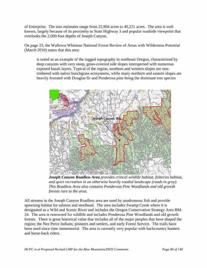
HCPC et al Proposed Revised LMP for the Blue Mountains/DEIS Comments Page 80 of 140
of Enterprise. The size estimates range from 25,904 acres to 40,221 acres. The area is well known, largely because of its proximity to State Highway 3 and popular roadside viewpoint that overlooks the 2,000-foot depths of Joseph Canyon. On page 23, the Wallowa-Whitman National Forest Review of Areas with Wilderness Potential (March 2010) states that this area:
is noted as an example of the rugged topography in northeast Oregon, characterized by deep canyons with very steep, grass-covered side slopes interspersed with numerous exposed basalt layers. Typical of the region, southern and western slopes are non-timbered with native bunchgrass ecosystems, while many northern and eastern slopes are heavily forested with Douglas-fir and Ponderosa pine being the dominant tree species
Joseph Canyon Roadless Area provides critical wildlife habitat, fisheries habitat, and quiet recreation in an otherwise heavily roaded landscape (roads in grey). This Roadless Area also contains Ponderosa Pine Woodlands and old growth forests rare to the area.
All streams in the Joseph Canyon Roadless area are used by anadromous fish and provide spawning habitat for salmon and steelhead. The area includes Swamp Creek where it is designated as a Wild and Scenic River and includes the Oregon Conservation Strategy Area BM-24. The area is renowned for wildlife and includes Ponderosa Pine Woodlands and old growth forests. There is great historical value that includes all of the major peoples that have shaped the region; the Nez Perce Indians; pioneers and settlers, and early Forest Service. The trails have been used since time immemorial. The area is currently very popular with backcountry hunters and horse-back riders.

HCPC et al Proposed Revised LMP for the Blue Mountains/DEIS Comments Page 81 of 140
During a meeting to decide which areas to include as recommend wilderness in the revised forest plan for the Wallowa-Whitman National Forest, the Forest Service identified the semi-primitive mechanized recreation opportunities (emphasis added) as the only reason why the Joseph Canyon should not be administratively recommended as wilderness. Wallowa-Whitman National Forest Proposal Meeting Notes, La Grande Oregon (January 29, 2008). Historically, motorized use in this area has been non-existent. The recent insignificant motorized use, if anything, should provide justification to protect this wild area before it is too late. Bear hunters recently discovered ATV tracks at the confluence of Davis and Swamp Creeks and reported this to ODFW due to their concerns about impacts to the trails from ATV’s. ATV’s had never been in this area before. In contrast, traditional quiet recreation has been well established for as long as anyone can remember. The Forest Service should take action to protect this area before the long tradition of quiet recreation in this area is lost forever. Furthermore, the benefits of permanently protecting this area’s history, culture, and ecology far outweigh any motorized opportunities it provides. There are millions of acres of other areas for forest users to take advantage of motorized recreation opportunities.
Reasons for administrative wilderness recommendation
• The Joseph Canyon Roadless Area has a well-established and long history of backcountry hunting, horseback riding, and hiking, and is increasingly threatened by OHV’s. The potential for conflict between user groups in this area is very high.
• Chico Trail has high historic value as a quiet use trail.
• Natural quiet and solitude values need protecting in Joseph Canyon.
• The Forest Service needs to safeguard wildlife habitat security in this otherwise roaded area.
• The Joseph Canyon Roadless Area is an important connectivity corridor between the Hells Canyon National Recreational Area/Wilderness and the Wenaha-Tucannon Wilderness. Joseph Canyon is a “stepping stone” and stop over area for dispersing and migrating wildlife.
• The Joseph Canyon Roadless Area contains old growth dry plant association groups currently underrepresented in the Blue Mountains Wilderness preservation system.
• The Joseph Canyon Roadless Area contains important steelhead spawning habitat and a Wild and Scenic River.
Hellhole (Umatilla National Forest): Just north of Mt. Emily and about 10 miles out of La Grande lies an enormous area of canyons and forests that occupies one of the most connective, undeveloped regions of lands left on the Umatilla National Forest. Interestingly, the actual “Hellhole” is seldom visited and considered deep backcountry. It further forms a connection with the tiny North Fork Umatilla Wilderness Area and then more roadless country to the north that adjoins the Wenaha-Tucannon Wilderness Area. This is a critical connective corridor. The Hellhole is remote, has high natural solitude, and is a perfect place to let natural systems function

HCPC et al Proposed Revised LMP for the Blue Mountains/DEIS Comments Page 82 of 140
(see Figures below). The Hellhole Roadless Area should be eagerly proposed and designated as Wilderness. It would be an asset well beyond that which most people understand. The area provides a large area of big game winter range. There are many old growth forests throughout the area.
Hellhole Roadless Area overlaid on a land cover map. The Hellhole extends across an important corridor of the Umatilla National Forest and forms a critical large scale animal movement and plant migration corridor. Wilderness designation would be the best and highest use of this land for many reasons, including climate change preparation.
Hellhole Roadless Area on Digital Elevation Model. This image illustrates that the Hellhole Roadless Area boundary includes high ridges along the Southeast boundary and then drops down to Meacham Creek (West boundary) and the Umatilla River (North boundary). Reserves

HCPC et al Proposed Revised LMP for the Blue Mountains/DEIS Comments Page 83 of 140
that include broad elevational gradients have exceptional value for biological conservation. The Hellhole is one of the most important areas to protect on the Umatilla National Forest. Murderer’s Creek (Malheur National Forest): Aldrich ridge and the surrounding approximately 44,000 acre roadless area that has been referred to as the Murderer’s Creek Roadless Area is an ecologically rare never-logged undeveloped roadless area forest. The contiguous roadless extent of this area includes the 5,000+ acre Aldrich, Dry Cabin, & Cedar Grove inventoried and uninventoried roadless areas, adjoining BLM and Oregon State lands, and the Todd roadless area, along with a mix of other uninventoried unroaded contiguous forests. This area includes redband trout and steelhead salmonid spawning streams and focal old forest habitat for American marten; wolverine; goshawk; Lewis,’ black-backed, pileated and other woodpeckers; a host of neotropical migrant and native avian species; and other old growth forest dependent species (see photo at left). Its forests include the only Alaskan Yellow Cedar Grove remaining in the greater region. The area supports an abundant diversity of rare native forest flowers and plants. Forest soil communities are among the most ecologically intact remaining in the Blue Mountains region. The roadless forests include numerous springs, seeps, bogs, marshes, ponds, and waterways. Evidence of pre-European settlement era native presence abounds, including obsidian flake scatter sites, hunting points, trails, and campsites. Its watersystems are important salmonid tributaries to the Middle Fork John Day River. Adjoining roadless areas (Field Peaks, Moon Mountain and others) connect this large roadless expanse with the Strawberry Wilderness to the east and the Black Canyon Wilderness and Spanish Peaks roadless in the Malheur National Forest to the west.
This roadless area has been proposed for wilderness since the 1970’s. Ecologically inappropriate harmful Forest Service logging and management projects, including the Aldrich, JOBS, Billy I and II, Thorn, and others, have been the source of public community contention, appeals, and litigation over the course of the previous decades. Each of these projects has been prevented from incurring harms in this rare ecologically intact large
roadless area.

HCPC et al Proposed Revised LMP for the Blue Mountains/DEIS Comments Page 84 of 140
The area is poised to play an irreplaceable role in the maintenance of numerous regional and listed species and species of concern. Far ranging species such as wolves, wolverine, and lynx have potential habitat, refugia, and transitory connective habitat with adjoining roadless and wilderness to the east and west located along and near the geological fault line that raised the Aldrich ridge and connected ridges spanning from the Ochoco to the Strawberry wilderness. It is imperative that the adopted forest plans provide permanent protection for this rare ecologically intact forest ecosystem and the many wildlife, avian, botanical, and aquatic regional species of concern and federal and state listed species this area supports. The forest plans must protect the unlogged roadless character of the entire contiguous approximately 44,000+/- roadless potential wilderness area, and begin the substantive process towards its eventual wilderness designation.
Murderer’s Creek Roadless Area (red boundary): Protecting the East-West corridor stretching from the Strawberry Mountains and across the Aldrich Mountains is essential for connectivity. Murderer’s Creek Roadless Areas is the largest contiguous Roadless Area in this area serving as critical core habitat for wildlife.
3. The adopted forest plans must incorporate stronger standards and guidelines for congressional designated wilderness areas, recommended wilderness areas and wilderness study areas
Standards and guidelines are at the heart of a forest plan. They serve as the basis for future decisions. Maintaining wilderness values is a responsibility the agency has under the Wilderness Act and is not discretionary. Thus, we believe the following changes should be incorporated into
HCPC et al Proposed Revised LMP for the Blue Mountains/DEIS Comments Page 85 of 140
the selected alternative: (italics are used for additions. Strikethroughs are used to delete a word. Bulleted points are additional comments.) MA 1A WIL-1: S-19 Standard. With the exception of permitted livestock, animals other than pack stock and pets (see glossary) shall not be authorized or allowed in wilderness areas.
• See comments to RNG-11: S-4 Standard above. Separation between pack goats and bighorn sheep must be maintained.
MA 1A WIL-2: S-28 Standard. Wheeled vehicles, such as wagons and game carts, shall not be authorized or allowed within wilderness areas. MA 1A WIL-3: G-61 Guideline. Standard. New proposals for outfitter and guide special use permits or recreation event permits should shall be approved only when the special use or event is consistent with wilderness area desired conditions and a need is identified by a needs assessment and capacity analysis. MA 1A WIL-4: G-63 Guideline. Standard. Party sizes greater than 12 people and/or 18 head of stock should shall not be authorized or allowed within wilderness areas. MA 1A WIL-5: G-64. Guideline. Standard. The hitching or tethering of a horse or other saddle or pack animal should shall be not be authorized or allowed within 200 feet of lakes or within 100 feet of streams and posted wetlands within wilderness areas. MA 1A WIL-6: S-29. Standard. Hitching or tethering of horses or other saddle or pack animals to trees, except for loading or unloading, shall not be authorized or allowed at campsites within wilderness areas. MA 1A MAL-WIL-1: S-25. Standard. Storing or abandoning personal property, equipment, and supplies for more than 72 hours shall not be authorized or allowed in the Strawberry Mountain Wilderness Area. MA 1A MAL-WIL-2: G-62. Guideline. Standard. Camping and campfires should shall not be authorized or allowed within 200 feet of lakes, streams, or other camps within wilderness areas. MA 1A UMA-WIL-2: G-62. Guideline. Standard. Camping and campfires should shall not be authorized or allowed within 200 feet of lakes, streams, or other camps within wilderness areas. MA 1A WIL-FIRE-1: G-65. Guideline. Standard. All firelines should shall be restored by actions such as scattering slash piles along and onto firelines, knocking down or burning all slash piles greater than 18 inches tall, pulling back and covering all sod with slash, and placing boulders, logs, and slash on firelines to discourage use and camouflage entrance points. Additionally, all firelines that are within 100 feet of intercepting trails, roads, or stream crossings should shall be restored by cutting stumps flush and close to the ground (height of 4 to 5 inches), covering tops with a layer of soil (1 to 2 inches), and chopping and roughening the ends of logs and stumps.
HCPC et al Proposed Revised LMP for the Blue Mountains/DEIS Comments Page 86 of 140
MA 1A WIL-FIRE-2: G-66. Guideline. Standard. Waterbars should shall be constructed on fireline slopes that exceed 10 percent. MA 1A WIL-FIRE-3: G-67. Guideline. Standard. Garbage and trash should shall be removed. MA 1A WIL-FIRE-4: G-68. Guideline. Standard. Camps should shall be restored by replacing logs and rocks, recontouring terrain, scarifying soil, and scattering twigs, rocks, and dead branches to discourage use and camouflage entrance points. MA 1A WIL-FIRE-5: G-69. Guideline. Standard. Closed roads that were opened to provide access to wilderness areas should shall be closed after the use has concluded. MA 1A WIL-FIRE-6: G-70. Guideline. Standard. Wilderness trails used as used as firelines should shall be returned to original condition after the use has concluded. MA 1B/C WIL-ST-1 G-71. Guideline. Standard. Existing and proposed uses that could compromise wilderness area eligibility prior to congressional designation should shall not be authorized.
Additionally, new standards and guidelines should be drafted:
• Requiring that the ecological role of fire within wilderness areas would be maintained as a natural process and naturally-ignited fires would be allowed to burn without suppression unless private lands adjacent to the wilderness are at risk, or for public health and safety reasons.
• Prohibiting the use of bulldozers, trucks, chainsaws or other motorized tools to put out fire within wilderness areas unless it is necessary to protect private lands or for public health and safety reasons.
• Requiring all visitors to pick up and pack out all litter and trash.
• When campsite condition surveys indicate a need for change in stock use policy the following actions should be considered
• Limit overnight camping to an appropriate number of nights for any one site.
• Designate specific campsites for stock use.
• Limit the number of stock allowed when camping overnight.
• Permit no overnight grazing of pack and saddle stock.
• Prohibit use of stock where warranted.
H. The DEIS did not adequately consider protection of Wild and Scenic Rivers
HCPC et al Proposed Revised LMP for the Blue Mountains/DEIS Comments Page 87 of 140
The Wild and Scenic Rivers Act is the nation’s primary river conservation tool. When it passed the Act in 1968, Congress declared that certain selected rivers shall be protected for the benefit and enjoyment of present and future generations. One of the Act’s mechanisms for the study and designation of new river components to the National Wild and Scenic River System is found in section 5(d), which requires “On all planning for the use and development of water and related land resources, consideration shall be given by all Federal agencies involved to potential national wild, scenic, and recreational river areas.” For National Forest lands, the Secretary of Agriculture is specifically charged in this section with determining which additional wild, scenic, and recreational river areas shall be evaluated in Forest Service planning reports. This mandate is further clarified by the 2012 planning rule13 and in the Forest Service Land Management Planning Handbook. The 2012 planning rule requires that plans include designated and eligible rivers as a plan component, and provide appropriate standards and guidelines for their protection. The rule also requires the responsible official to “Identify the eligibility of rivers for inclusion in the National Wild and Scenic Rivers System, unless a systematic inventory has been previously completed and documented and there are no changed circumstances that warrant additional review.” 36 C.F.R. § 219.7(c)(2)(vi) (2012). The Forest Service Handbook requires forest plans to include a comprehensive evaluation of the potential for rivers in a plan area to be eligible for inclusion in the National System by completing an inventory of eligible river segments and document this in an appendix of the environmental impact statement (EIS). Sources of information for identifying the significance of river-related values include the Nationwide Rivers Inventory; State river assessments; Tribal governments, other Federal, State, or local agencies; and the public. The agency must collaboratively involve the public throughout the evaluation process. FSH 1909.12, § 81.2: In accordance with the Wild and Scenic River Act at 5(d) (1) and Forest Service Manual policy (FSM 1924.03), to be eligible for designation, the river or stream must be perennial, free-flowing and possess one or more outstandingly remarkable values. According to the DEIS, in order to be assessed as outstandingly remarkable, a river-related value must be a unique, rare or exemplary feature that is significant to the Blue Mountains region. Vol. 3, p. 397. During scoping, we pointed out that the Forest Service did not adequately consider the protection of Wild and Scenic Rivers in the proposed action. In fact, during scoping many people expressed the inadequacy of the identification of eligible Wild and Scenic Rivers in accordance with the Wild and Scenic River Act. See DEIS, Vol. 1 p. 13. Despite this, all of the action alternatives developed would allocate fewer rivers as eligible for Wild and Scenic designation than the proposed action. Id at 197 to 198. Pre scoping, many of our groups recommended that certain river areas across the three forests be inventoried as eligible Wild and Scenic Rivers based on the above criteria. For the Malheur National Forest, those recommendations included Forest Big Boulder, Big Creek (Blue Mountain 13 While the LMP revision process for the Blue Mountains is occurring under the 1982 planning rule, the 2012 rule is instructive and the intent of this rule – as current Forest Service policy – should be followed.
HCPC et al Proposed Revised LMP for the Blue Mountains/DEIS Comments Page 88 of 140
Road), Granite Boulder, Big Creek/Lake Creek, the Little Malheur River, Murderer’s Creek, the Middle Fork John Day River, South Fork Long Creek, Silver Creek and Vinegar Creek. However, according to the Forest Service, none of these rivers was eligible. The Umatilla and Wallowa Whitman National Forest inventories are also severely lacking, but not to the extent of the Malheur. Such an inventory process is not based on “objective, comparative, scientific information” as claimed in the DEIS. Id at 398. It is a biased judgment that does not take into account the significance of river-related values identified by the public. Additionally, despite the controversy surrounding this issue, the DEIS fails to adequately analyze the impacts of the alternatives on potential national wild, scenic, and recreational river areas. NEPA requires agencies to “consider every significant aspect of the environmental impact of a proposed action” in an EIS. ONDA, 625 F.3d at 1100 (citing Vermont Yankee Nuclear Pwr. Corp. v. Natural Res. Def. Council, 435 U.S. 519, 553 (1978)). This includes studying the direct, indirect, and cumulative impacts of the action, see 40 C.F.R. §§ 1508.7, 1508.8, as well as studying “significant new circumstances or information relevant to environmental concerns and bearing on the proposed action or its impacts.” Id. § 1502.9(c)(1)(ii). Instead of studying the impacts of the forest plan alternative on rivers in the Blue Mountains, the DEIS summarily identifies which river areas are currently designated wild and scenic, which river areas are designated as eligible for designation, and how much acreage would be allocated to the Wild And Scenic Management Area (MA 2A) under each alternative. Simply disclosing this information is insufficient. The NEPA analysis must include an analysis of the direct, indirect and cumulative impacts on the designations and allocations of this important resource.
I. The Allowable Sale Quantity needs to be adjusted to harmonize and integrate all benchmarks
The DEIS and draft forest plans fail to adjust the Allowable Sale Quantity (ASQ) to account for wildfire (which is expected to increase due to climate change), and to insure compliance with requirements for the viability of species associated with dense forests and dead wood, which are likely to become depleted under the proposed plan for extensive logging for resilience and density reduction. The “benchmark” analysis required in 36 CFR 219.12(e) includes “(ii) The maximum physical and biological production potentials of significant individual goods and services together with associated costs and benefits,” thus, alternatives need to be considered that reduce ASQ and AUMs in order to maximize wildlife habitat, maximize carbon storage, maximize water quality, etc. The Forest Service has not met this requirement. The agency must reach a decision that harmonizes all these values, recognizing that widely shared public values like water quality, wildlife habitat, wilderness, carbon storage, and recreation, are all mutually reinforcing on public lands (and inadequately supported on non-federal lands), while logging and grazing on public lands detract significantly from public values, and forage and wood fiber are already provided on non-federal lands. The ASQ also needs to be adjusted to account for the compelling need to store carbon in forest ecosystems. In discussing the ASQ, the draft plans state “The nontimber benchmarks, including wildlife, wilderness areas, and range, were determined to be appropriate and reasonable,
HCPC et al Proposed Revised LMP for the Blue Mountains/DEIS Comments Page 89 of 140
therefore no new ones were developed.” This fails to meet NFMA requirements to maintain an inventory of resources and keep it current so as to address new and emerging resources. 16 USC § 1603. The draft plan fails to adequately address the “new and emerging” climate issues by allocating more carbon to living ecosystems that help keep carbon out of the atmosphere and allocate less carbon to harvest which unavoidably accelerates the transfer of carbon to the atmosphere where it exacerbates climate change.
J. Other issues with DEIS analysis Suitability analysis The NFMA regulations provide a tool for identifying resource conflicts and excluding inappropriate uses. The Forest Service must use this tool to protect public values such as clean water, fish and wildlife habitat, native plant communities and to reduce environmental stress in preparation for climate change. The DEIS lacks a grazing suitability analysis based on “environmental consequences and alternative uses forgone.” 36 C.F.R. §§ 219.3, 219.20. Livestock should be excluded from sensitive sites such as streamside areas, springs, wetlands, where weeds are likely to be spread, where they are likely to reduce fine fuels (such as bunchgrasses) and shift species composition toward ladder fuels (such as young conifers). Further refinement of “Landscape Pattern” objectives are needed The discussion of “landscape pattern” on page 45 of the draft plans are vague and should be strengthened. The desired condition should be to move toward the natural historic range of variability. Existing large patches of unroaded/unmanaged land should be protected. The Forest Service’ desire for managing stand structural conditions should not trump the need to protect and restore large patches of habitat that are rare and under-represented. The long-term recruitment of snags and dead wood on the landscape also depends on the Forest Service’ ability to leave large areas unmanaged so the full cycle of tree life and tree death can unfold without capturing and exporting mortality from the ecosystem. In light of climate change, specific spatial goals for landscape connectivity must be established. Focus on “Structure Ignition Zone” instead of Wildland Urban Interface (WUI) The Forest Service should adopt a more accurate and conservative definition of the wildland urban interface. The definition used in the Healthy Forest Restoration Act (HFRA) is for project planning, not for forest planning. The Forest Service should focus more on the structure ignition zone and look at a WUI more like this:

HCPC et al Proposed Revised LMP for the Blue Mountains/DEIS Comments Page 90 of 140
Early Seral Forests Much has been learned in recent decades about natural disturbance processes and the diverse values provided by naturally created complex early seral ecosystems. The forest plan must adopt a more modern approach to fire suppression and post fire activities. Fire, and other agents of mortality, are natural ecological processes. Forests have experienced fire and recovered from fire for millennia. Salvage logging after fire and other disturbances is not needed or desired. Salvage logging deprives the recovering forest of key ecological structures and processes and results in more simplified forests that do not meet desired objectives for water quality, habitat complexity, species conservation, carbon storage, etc. We support the proposed standards to leave large portions of burned areas untreated, and “Where salvage logging occurs, all snags 21 inches dbh and greater and 50 percent of the snags from 12 to 21 inches dbh. should be retained …” This standard should apply everywhere except within the structure ignition zone and hazard trees that pose an imminent hazard to high use areas. It is important to refine the standard that says “Greater than 50 percent of post-fire source habitat should be retained…” The post-fire retention areas should focus on unroaded areas and areas that have not been previously logged, so that natural processes can unfold. Salvage logging, if any, should focus on plantations or other areas where small trees are overabundant, and should focus on areas that are accessible from existing roads.
HCPC et al Proposed Revised LMP for the Blue Mountains/DEIS Comments Page 91 of 140
The draft plans’ discussion of disturbance regimes (LMP p 34) should express the desire for natural recovery after disturbance. Specifying the relative proportion of fire severity for each PVG does not mean much of the burns are salvage logged. Much of the discussion on page 34 is based on the Blue Mountains Province as a whole including private lands (which have more dry forest that are more departed from HRV) rather than the National Forest lands (which have more moist-mixed conifer forest that are less departed form HRV). This tends to blur the real ecological priorities on the public lands. Conservation best supports community resilience and economic well-being The forest plan should recognize that community resilience and economic well-being are not well-supported by the timber industry which tends to boom and bust according to interest rates, housing starts, and financial bubbles. Logging and grazing also entail significant “externalities” which allow profits for a few while imposing costs on the public. Community stability and economic well-being are supported much more by managing the forests for ecosystem services and quality of life that attracts people who want to live and work near scenic and recreational areas. The Forest Service should establish “desired conditions” for economic well-being that are provided by non-market goods and services like clean water, carbon storage, recreation, scenery, and quality of life. The “General Forest” land allocation should support public values, not timber production We urge the Forest Service to do away with the “general forest” land allocation. It has a tendency to be interpreted as a place where timber harvest (for private profit, regardless of externalities) is the highest and best use, when in reality the general forest should be managed for the harmonious provision of public values, including clean water, watershed integrity, fish and wildlife habitat, carbon storage, recreation, and quality of life. Restoration Priorities We agree with some of the restoration priorities in the draft plan (LMP p. 98):
• Concentrating active restoration activities (timber harvest, fire, and thinning) primarily, but not exclusively, in the dry environment, as the dry vegetation type is generally the most departed from the desired condition.
• Concentrating active restoration in areas with established road systems and previous treatments (plantations, past thinning areas, etc.).
• Using planned and unplanned fire to accomplish restoration objectives.

HCPC et al Proposed Revised LMP for the Blue Mountains/DEIS Comments Page 92 of 140
References Agee, J.K. (2003) Monitoring postfire tree mortality in mixed conifer forests of Crater Lake,
Oregon, USA. Natural Areas Journal, 23, 114–120.
Baker, W.L. 2009. Fire ecology in Rocky Mountain landscapes. Island Press, Oxford.
Baker, W.L., T.T. Veblen, and R.L. Sheriff. 2007. Fire, fuels and restoration of ponderosa pine-Douglas fire forests in the Rocky Mountains, USA. Journal of Biogeography 34: 251-269.
Beier, P., E. C., and M. F. Ingraldi 2012. Commentary: There Is No Evidence That the Forest Service’s Goshawk Recommendations Improve Goshawk Nest Productivity. Wildlife Society Bulletin; DOI: 10.1002/wsb.122.
Beschta, R.L., J.J. Rhodes, J.B. Kauffman, R.E. Gresswell, G.W. Minshall, J.R. Karr, D.A. Perry, E.R. Hauer, and C.A. Frissell. 2004. Postfire management on forested public lands of the western USA. Conservation Biology 18: 957-967.
Beschta, Robert L., et al. "Adapting to climate change on Western public lands: Addressing the ecological effects of domestic, wild, and feral ungulates."Environmental management 51.2 (2013): 474-491.
Bond, M.L., D.E. Lee, C. M. Bradley, and C.T. Hanson. 2009. Influence of Pre-Fire Tree Mortality on Fire Severity in Conifer Forests of the San Bernardino Mountains, California. The Open Forest Science Journal, 2, 41-47.
Brown, R. T., J. K. Agee, and J. F. Franklin. 2004. Forest Restoration and Fire: Principles in the Context of Place. Conservation Biology. 18: 903-912.
Campbell, J., D. Donato, D. Azuma, and B. Law. 2007. Pyrogenic carbon emission for a large wildfire in Oregon, United States. Journal of Geophysical Research 12: G04014, doi:10.1029/2007JG000451.
Cochran, P. H., J. M. Geist, D. L. Clemens, R. R. Clausnitzer, and D. C. Powell. 1994. Suggested Stocking Levels for Forest Stands in Northeastern Oregon and Southeastern Washington. PNW-RN-513.
Cook, C. N., M. Hockings, & R.W. Carter. 2010. Conservation in the dark? Information used to support management decisions. Front Ecol Environ. 8(4): 181-186.
Crist, M.R., T.H. DeLuca, B. Wilmer, and G.H. Aplet. 2009. Restoration of Low- Elevation Dry Forests of the Northern Rocky Mountains: A Holistic Approach. Washington, D.C.: The Wilderness Society.
Cyr, D., S. Gauthier, Y. Bergeron, and C. Carcaillet. 2009. Forest Management is driving the eastern North American boreal forest outside its natural range of variability. Frontiers in Ecology and the Environment. 7(10): 519-524.

HCPC et al Proposed Revised LMP for the Blue Mountains/DEIS Comments Page 93 of 140
DellaSala, D. A., A. Martin, R. Spivak, T. Schulke, B. Bird, M. Criley, C. van Daalen, J. Kreilick, R. Brown, and G. Aplet. 2003. A citizen’s call for ecological forest restoration: Forest restoration principles and criteria. Ecological Restoration. 21: 14-23.
Deller, S. C., T.-H. Tsai, et al. 2001. The Role of Amenities and Quality of Life in Rural Economic Growth. American Journal of Agricultural Economics 83(2): 352-365.
Depro, B., Murray, B., Alig, R., Shanks, A. 2008. Public land, timber harvests, and climate mitigation: quantifying carbon sequestration potential on U.S. public timberlands. Forest Ecology and Management. 255(3-4): 1122-1134
Franklin, J.F., Johnson, K.N.,. 2012. A Restoration framework for federal forests in the Pacific Northwest. J. For. 110(8): 429-439.
Franklin, J.F. & D. B. Lindenmayer. 2009. Importance of matrix habitats in maintaining biological diversity. Proceedings of the National Academy of Science. 106, 349-350.
Frey, W.H. 2006. America’s Regional Demographics in the ’00 Decade: The Role of Seniors, Boomers and New Minorities. The Brookings Institution, Washington, D.C.
Gelbard, J.L., and S. Harris. 2005. Invasibility of roadless grasslands: an experimental study of yellow starthistle. Ecological Applications 15(5):1570-1580.
Hanson C. 2010. The Myth of “Catastrophic” Wildfire. A New Ecological Paradigm of Forest Health. Report available at http://www.johnmuirproject.org/documents/Hanson%20White%20Paper%2029Jan10%20Final.pdf
Hanson, C.T., and M.P. North. 2008. Postfire woodpecker foraging in salvage-logged and unlogged forests of the Sierra Nevada. The Condor 110: 777-782.
Headwaters Economics. 2012. West Is Best. http://headwaterseconomics.org/land/west-is-best-value-of-public-lands.
Hessburg, P.F., R.B. Salter, and K.M. James. 2007. Re-examining fire severity relations in pre-management era mixed-conifer forests: inferences from landscape patterns of forest structure. Landscape Ecology 22: 5-24.
Heyerdahl, E. K., L. B. Brubaker, and J. K. Agee. 2001. Spatial Controls of Historical Fire Regimes: A Multiscale Example from the Interior West, USA. Ecology. 82: 660-678.
Heyerdahl, E. K., P. Morgan, J. P. Riser II. 2008. MULTI-SEASON CLIMATE SYNCHRONIZED HISTORICAL FIRES IN DRY FORESTS (1650–1900), NORTHERN ROCKIES, USA. Ecology, 89(3), 705-716.
Holling, C.S. and G. K. Meffe. 1996. Command and Control and the Pathology of Natural Resource Management. Conservation Biology 10, no. 2, 328-337.
HCPC et al Proposed Revised LMP for the Blue Mountains/DEIS Comments Page 94 of 140
Hudiburg, T., B. Law, D.P. Turner, J. Campbell, D. Donato, and M. Duane. 2009. Carbon dynamics of Oregon and northern California forests and potential land-based carbon storage. Ecological Applications 19(1): 163-180.
Hutto, R.L. 1995. The composition of bird communities following stand-replacement fires in northern Rocky Mountain (U.S.A.) conifer forests. Conservation Biology 9:1041-1058.
Hutto, R.L. 2006. Toward meaningful snag-management guidelines for postfire salvage logging in North American conifer forests. Conservation Biology 20: 984-993.
Hutto, R. L., and S. M. Gallo. 2006. The effects of postfire salvage logging on cavity-nesting birds. Condor 108:817–831.
Hutto, R. L. 2008. The Ecological Importance of Severe Wildfires: Some Like it Hot. Ecological Applications, 18(8); 1827-1834.
IPCC, Climate Change 2007: The Physical Science Basis. Contribution of Working Group 1 to the Fourth Assessment Report of the Intergovernmental Panel on Climate Change, S. Solomon et al., Eds. (Cambridge Univ. Press, Cambridge, UK, and New York, NY, 2007).
Karr, J.R. 2009. Natural: a benchmark, not a bias. Northwest Science 83(3):294-297.
Karr, J.R., and E.W. Chu. 1995. Ecological integrity: reclaiming lost connections. Pp. 34-48 in L. Westra and J. Lemons (eds.), Perspectives on ecological integrity. Dordrecht, The Netherlands: Kluwer Academic Publishers.
Karr, J.R., J.J. Rhodes, G.W. Minshall, F.R. Hauer, R.L. Beschta, C.A. Frissell, and D.A. Perry. 2004. Postfire salvage logging's effects on aquatic ecosystems in the American West. BioScience 54: 1029-1033.
Kauffman, J.B., R.L. Beschta, N. Otting, and D. Lytjen. 1997. An ecological perspective of riparian and stream restoration in the western United States. Fisheries 22:12-24.
Keeling, E.G., A. Sala, T.H. DeLuca. 2006. Effects of fire exclusion on forest structure and composition in unlogged ponderosa pine/Douglas-fir forests. Forest Ecology and Management, 237, pp. 418-428.
Keith, H., B.G. Mackey, and D. B. Lindenmayer. 2009. Re-evaluation of forest biomass Carbon stocks and lessons from the world’s most carbon dense forests. Proceedings of the National Academy of Sciences 106 (28):11635-11640.
Klenner, W., R. Walton, A. Arsenault, and L. Kremsater. 2009. Dry forests in the southern interior of British Columbia: historic disturbances and implications for restoration and management. Forest Ecology and Management 256: 1711-1722.
Kim, Helen M., Chopping Down the Birds: Logging and the Migratory Bird Treaty Act, 31 Envtl. L. 125 (2001).
Greenwald, Crocker-Bedford, Broberg, Suckling, and Tibbitts. 2005. A review of Northern goshawk habitat selection in the home range and implications for forest management in the
HCPC et al Proposed Revised LMP for the Blue Mountains/DEIS Comments Page 95 of 140
western United States. Wildlife Society Bulletin 33(1):120-129. available at: http://www.fs.usda.gov/Internet/FSE_DOCUMENTS/fsbdev3_021122.pdf
Government Accountability Office. (2007). Climate change: Agencies should develop guidance for addressing the effects on federal land and water resources. (GAO Publication No. 07-863). Washington, D.C.: U.S. Government Printing Office.
Law, B. & M.E. Harmon 2011. Forest sector carbon management, measurement and verification, and discussion of policy related to mitigation and adaptation of forests to climate change. Carbon Management 2011 2(1). Available at: http://terraweb.forestry.oregonstate.edu/pubs/lawharmon2011.pdf.
Leege, T. A. 1984. Guidelines for evaluating and managing summer elk habitat in northern Idaho. Idaho Department of Fish and Game, Wildlife Bulletin 11, Boise, Idaho
Lindenmayer, D.B. J.F. Franklin, & J. Fischer. 2006. General management principles and a checklist of strategies to guide forest biodiversity conservation. Biological Conservation, 131, 433-445.
Littell, J.S., D. McKenzie, D.L. Peterson, A.L. Westerling. 2009. Climate and wildfire area burned in western U.S. ecoprovinces, 1916-2003. Ecological Applications. 19(4), 1003-1021.
Lorah, P. R. Southwick, et al. 2003. Environmental Protection, Population Change, and Economic Development in the Rural Western United States. Population and Environment 24(3): 255-272.
Littell, J.S., D. McKenzie, D.L. Peterson, A.L. Westerling. 2009. Climate and wildfire area burned in western U.S. ecoprovinces, 1916-2003. Ecological Applications. 19(4), 1003-1021.
Luyssaert, S., E. Detlef Schulz, A. Borner, A. Kohl, D. Hessenmoller, B.E. Law, et al. 2008. Old-growth forests as global carbon sinks. Nature 455:213-215.
MA (Millennium Ecosystem Assessment). 2005. Ecosystems and human well-being. Synthesis. Washington, DC: Island Press.
Mansfield, H. 2000. The Same Ax, Twice. Restoration and Renewal in a Throwaway Age. University Press of New England, Hanover, NH 03755.
Meigs, G.W., D.C. Donato, J.L. Campbell, J.G. Martin, and B.E. Law. 2009. Forest fire impacts on carbon uptake, storage, and emission: the role of burn severity in the Eastern Oregon Cascades. Ecosystems 12:1246-1267.
McGranahan, D. A. 1999. Natural Amenities Drive Rural Population Change. E. R. S. U.S. Department of Agriculture. Washington, D.C.
McIver J. & L. Starr. 2001. Restoration of degraded lands in the interior Columbia River basin: passive vs. active approaches. Forest Ecology and Management. Vol 153: 15-28.
HCPC et al Proposed Revised LMP for the Blue Mountains/DEIS Comments Page 96 of 140
Mildrexler, D. J., Zhao, M., Heinsch, F. A., & Running, S.W. 2007. A new satellite-based methodology for continental scale disturbance detection. Ecological Applications, 17, 235−250.
Mildrexler, D. J., Zhao, M., & Running, S.W. 2009. Testing a MODIS Global Distrubance Index across North America. Remote Sensing of Environment, 113, 2103-2117.
Millar, C. I., N. L. Stephenson, and S. L. Stephens. 2007. Climate Change and Forests of the Future: Managing in the Face of Uncertainty. Ecological Applications. 17:2145-2151.
Mitchell, S.R., M.E. Harmon, and K.E.B. O’Connell. 2009. Forest fuel reduction alters fire severity and long-term carbon storage in three Pacific Northwest ecosystems. Ecological Applications 19:643-655.
Morgan, P., E. K. Heyerdahl & C. E. Gibson. 2008. MULTI-SEASON CLIMATE SYNCHRONIZED FOREST FIRES THROUGHOUT THE 20TH CENTURY, NORTHERN ROCKIES, USA. Ecology, 89(3), 717-728.
Muller J, Bubler H, Gobner M, RettelbachT, & P. Duelli. 2008. The European spruce bark beetle Ips typographus in a national park: from pest to keystone species. Biodivers Conserv. 17: 2979-3001.
Naficy, C., and A. Sala. 2007. Logging exacerbates the effects of fire exclusion on stand density in ponderosa pine forests of the Northern Rockies over the long term. Annual Meetings of the Ecological Society of America, San Jose, CA.
Nie, Martin and Courtney Schultz. 2011. Decision Making Triggers in Adaptive Management: Report to USDA Pacific Northwest Research Station, NEPA for the 21st Century.
Nie, Martin and Emily Schembra. 2013. Evaluating the Role of Standards in U.S. National Forest Planning.
Nie, Martin and Emily Schembra. 2014. The Important Role of Standards in National Forest Planning, Law, and Management. 44 ELR 10281.
Noss, R.F., J.F. Franklin, W.L. Baker, T. Schoennagel, and P.B. Moyle. 2006. Managing fire-prone forests in the western United States. Frontiers in Ecology and Environment 4: 481-487.
Reed F. Noss (2001) Beyond Kyoto: Forest Management in a Time of Rapid Climate Change. Conservation Biology 15 (3), 578–590. Available at: http://www.sustainablenorthwest.org/wss/wssagenda/wss‐web‐library/making‐forests‐resilient‐web‐library/Noss_2001.pdf.
Noss, Reed F. 2001. Biocentric Ecological Sustainability: A Citizen’s Guide. Louisville, CO: Biodiversity Legal Foundation. 12pp.
Noss, R.F., and A.Y. Cooperrider. 1994. Saving nature’s legacy. Washington, D.C.:Island Press.
Outdoor Industry Foundation. 2012. The Outdoor Recreation Economy Report.
HCPC et al Proposed Revised LMP for the Blue Mountains/DEIS Comments Page 97 of 140
Pierce, J.L., G.A. Meyer, and A.J.T. Jull. 2004. Fire-induced erosion and millennial-scale climate change in northern ponderosa pine forests. Nature 432: 87-90.
Pimentel, D., L. Westra, and R.F. Noss (eds.). 2000. Ecological integrity: integrating environment, conservation, and health. Washington D.C.: Island Press.
Potter, C., Tan, P., Steinback, M., Klooster, S., Kumar, V., Myneni, R., et al. (2003). Major disturbance events in terrestrial ecosystems detected using global satellite datasets. Global Change Biology, 9, 1005−1021.
Rainville R, R. White, J Barbour. 2008. Assessment of timber availability from forest restoration within the Blue Mountains of Oregon. Gen. Tech. Rep. PNW-GTR-752. Portland, OR: USDA, Forest Service, Pacific Northwest Research Station. 65 p.
Rasker, Ray, Ben Alexander, Jeff van den Noort, and Rebecca Carter, “Prosperity in the 21st Century West: The Role of Protected Public Lands” (Tucson: Sonoran Institute, 2004), available at http: http://web.archive.org/web/20070105005615/http://sonoran.org/pdfs/Prosperity%20Report.pdf
Rasker, R. 2006. An exploration into the economic impact of industrial development versus conservation on western public lands. Society & Natural Resources, 19(3), 191–207.
Rasker, R., P.H. Gude, M. Delorey. 2013. The Effect of Protected Federal Lands on Economic Prosperity in the Non-Metropolitan West., Journal of Regional Analysis and Policy.
Rhodes, J.J. 2007. The watershed impacts of Forest Treatments To Reduce Fuels and Modify Fire Behavior. Commissioned by Pacific River Council, 94 pp.
Rhodes, J. J., W. L. Baker. 2008. Fire Probability, Fuel Treatment Effectiveness and Ecological Tradeoffs in Western U.S. Public Forests. The Open Forest Science Journal. 1: 1-7.
Roloff, G. J. 1998. Habitat potential model for Rocky Mountain elk. In Proceedings 1997 Deer/Elk Workshop, Rio Rico, Arizona, ed. J. C. deVos, Jr., 158-175. Phoenix: Arizona Game and Fish Department.
Romme, W. H., J. Clement, J. Hicke, D. Kulakowski, L. H. MacDonald, T. Schoennagel, and T. T. Veblen. 2006. Recent forest insect outbreaks and fire risk in Colorado forests: a brief synthesis of relevant research. Colorado Forest Restoration Institute, Fort Collins, CO. 24 pages.
Rowland, M. M., M. J. Wisdom, B. K. Johnson, and J. G. Kie. 2000. Elk distribution and modeling in relation to roads. Journal of Wildlife Management 64:672-684.
Rowland M. M., M. J. Wisdom, B. K. Johnson, and M. A. Penninger. 2005. Effects of Roads on Elk: Implications for Management in Forested Ecosystems. Pages 42-52 in Wisdom, M. J., technical editor, The Starkey Project: a synthesis of long-term studies of elk and mule deer. Reprinted from the 2004 Transactions of the North American Wildlife and Natural Resources Conference, Alliance Communications Group, Lawrence, Kansas, USA.
HCPC et al Proposed Revised LMP for the Blue Mountains/DEIS Comments Page 98 of 140
Sanderson E.W., Jaiteh M., Levy M.A., Redford K.H., Wannebo A.V., and G. Woomer. 2002. The Human Footprint and the Last of the Wild. BioScience Vol. 52. No. 10.
Sharp, Brian E. 1996. Avian Population Trends in the Pacific Northwest. Bird Populations 3: 26–45.
Sherriff, R.L., and T.T. Veblen. 2006. Ecological effects of changes in fire regimes in Pinus ponderosa ecosystems in the Colorado Front Range. Journal of Vegetation Science 17: 705-718.
Sherriff, R.L., and T.T. Veblen. 2007. A spatially-explicit reconstruction of historical fire occurrence in the Ponderosa pine zone of the Colorado Front Range. Ecosystems 10: 313-323.
Smithwick, E.A.H., M.E. Harmon, and J.B. Domingo. 2002. Changing temporal patterns of forest carbon stores and net ecosystem carbon balance: the stand to landscape transformation. Landscape Ecology 22:77-94.
Strittholt, J.R., and D.A. DellaSala. 2001. Importance of roadless areas in biodiversity conservation in forested ecosystems: a case study – Klamath-Siskiyou ecoregion, U.S.A. Conservation Biology Vol. 15(6):1742-1754.
Swanson, M.E., J.F. Franklin, R.L. Beschta, C.M. Crisafulli, D.A. DellaSala, R.L. Hutto, D.B. Lindenmayer, and F.J. Swanson. 2010. The forgotten stage of forest succession: early-successional ecosystems on forest sites. Frontiers in Ecology and Environment doi: 10.1890/090157
U.S. Forest Service, National Roadmap for Responding to Climate Change (2010), available at: http://www.fs.fed.us/climatechange/pdf/roadmap.pdf
United Nations Environmental Programme (UNEP). 2002: Report of the Sixth Meeting of the Conference of the Parties to the Convention on Biological Diversity (UNEP/CBD/COP/6/20). Decision VI/26, UNEP..
Veblen, T. T. and Hadley, K. S. R., M.S. Reid. 1991. Disturbance and stand development of a Colorado subalpine forest. Journal of Biogeography 18: 707-716.
Veblen, T.T., T. Kitzberger, and J. Donnegan. 2000. Climatic and human influences on fire regimes in ponderosa pine forests in the Colorado Front Range. Ecological Applications 10:1178-1195.
Vitousek, P., C. D’Antonia, L.L. Loope, & R. Westbrooks. 1996. Biological Invasions as Global Environmental Change. American Scientist, Vol. 84.
Wales, B. C., Suring, L. H., and M. A. Hemstrom. 2007. Modeling potential outcomes of fire and fuel management scenarios on the structure of forested habitats in northeast Oregon, USA. Landscape and Urban Planning. 80:223-236.

HCPC et al Proposed Revised LMP for the Blue Mountains/DEIS Comments Page 99 of 140
Waring, R. H., T. Savage, K. Cromack, Jr., and C. Rose. 1992. Thinning and nitrogen fertilization in a grand fir stand infested with western spruce budworm. Part IV.An ecosystem management perspective. Forest Science 38:275-286.
Westerling, A.L., H.D. Hidalgo, D.R. Cayan, and T.W. Swetnam. 2006. Warming and earlier pring increase Western U.S. forest wildfire activity. Science 313:940-943.
Whitlock, C., J. Marlon, C. Briles, A. Brunelle, C. Long, and P. Bartlein. 2008. Long-term relations among fire, fuel, and climate in the north-western US based on lake-sediment studies. International Journal of Wildland Fire 17: 72-83.
Zhou, G., Liu, S, Li, Z., Zhang, D., Tang, X., Zhou, C., Yan, J., & J. Mo. 2006. Old-Growth Forests Can Accumulate Carbon in Soils. Science, 314, pg 1417.
CLIMATE CHANGE LITERATURE
Aplet, G.H., Anderson, H. M., and Wilmer, B. 2010. Managing the Risk of Climate Change to Wildlands of the Sierra Nevada: Research Paper. The Wilderness Society, Washington, D.C.
Aune, Keith, Paul Beier, Jodi Hilty & Fraser Shilling. 2011. Assessment and Planning for Ecological Connectivity: A Practical Guide. Wildlife Conservation Society. Bozeman, MT. 2011. Available at: http://www.wcsnorthamerica.com/DesktopModules/Bring2mind/DMX/Download.aspx?EntryId=7292&PortalId=37
Bakke, P. 2009. Physical processes and climate change: A guide for biologists. USFWS - Washington FWO, Lacey, WA - Revised April, 2009.
Barbour, E. and L.M. Kueppers. 2012. Conservation and management of ecological systems in a changing California. Climate Change (2012) 111: 135-163.
Baron Jill S., Linda A. Joyce. Guidelines for Helping Natural Resources Adapt to Climate Change. In Mountain News, Newsletter of the Consortium for Integrated Climate Research in Western Mountains. CIRMOUNT, Vol. 3, No. 1, February 2009. Available at: http://www.fs.fed.us/psw/cirmount/publications/pdf/Mtn_Views_feb_09.pdf
Blate, G.M., Joyce, L. A., Littell, J. S., McNulty, S. G., Millar, C. i., Moser, S. C., Neilson, R. p., O’Halloran, K. and Peterson, D. L. 2009. Adapting to climate change in United States national forests. Unasylva 231/232 (60): 57-62.
Climate Leadership Initiative. 2008. Preparing the Pacific Northwest for Climate Change – A Framework for Integrative Preparation Planning for Natural, Human, Built and Economic Systems. Institute for a Sustainable Environment. University of Oregon. February 4, 2008. Available at: https://scholarsbank.uoregon.edu/xmlui/bitstream/handle/1794/6989/Preparing_PacNW_for_ClimateChange_4‐2‐08.pdf?sequence=1
HCPC et al Proposed Revised LMP for the Blue Mountains/DEIS Comments Page 100 of 140
DelaSalla, Dominick 2013. Why Biodiversity is Important to Solving Climate Chaos: Top 10 Reasons. Island Press Field Notes Blog. Sept 13, 2013. Available at: http://ipfieldnotes.org/why‐biodiversity‐is‐important‐to‐solving‐climate‐chaos‐top‐10‐reasons/
Driscoll, D.A., Felton, A., Gibbons, P., Felton, A.M., Munro, N.T., and Lindenmayer, D.B. 2012. Priorities in policy and management when existing biodiversity stressors interact with climate-change. Climate Change (2012) 111:533-557.
Ecological Society of America POSITION STATEMENT: ECOSYSTEM MANAGEMENT IN A CHANGING CLIMATE. Available at: http://www.esa.org/pao/policyStatements/pdfDocuments/Ecosystem%20Management%20in%20a%20Changing%20Climate.pdf
Glick, P., B.A. Stein, and N.A. Edelson, eds. 2011. Scanning the Conservation Horizon: A Guide to Climate Change Vulnerability Assessment. National Wildlife Federation, Washington, D.C.
Hannah, L., Midgley, G. F., Lovejoy, T. E., Bond, W. J., Bush, M., Lovett, J. C., Scott, D. and Woodward, F. I. 2002. Conservation of biodiversity in a changing climate. Conservation Biology 16: 264-268.
Hannah, L. and Hansen, L. 2005. Designing landscapes and seascapes for change. Pages 329-341 in T.E. Lovejoy and L. Hannah, editors. Climate Change and Biodiversity. Yale University Press, New Haven, Connecticut.
Hampe, A. and Petit, R. J. 2005. Conserving biodiversity under climate change: the rear edge matters. Ecology Letters 8: 461–467.
Hansen, Lara J. and Jennifer R. Hoffman. 2011. Climate Savvy: Adapting Conservation and Resource Management to a Changing World. Washington, D.C.: Island Press. 245 p
Harris James A., Richard J. Hobbs, Eric Higgs, and James Aronson 2006. Ecological Restoration and Global Climate Change. Restoration Ecology Vol. 14, No. 2, pp. 170–176 JUNE 2006. http://www.cof.orst.edu/cof/teach/fs505/Readings/Harris%20ea%202006.pdf
Heller, N. E. and Zavaleta, E. S. 2009. Biodiversity management in the face of climate change: A review of 22 years of recommendations. Biological Conservation 142: 14 –3 2.
Innes, J., Joyce, L. A., Kellomaki, S., Louman, B., Ogden, A., Parrotta, J. and Thompson, I. 2009. Chapter 6: Management for adaptation. In R. Seppala, A. Buck and P. Katila (eds.), Adaptation of Forests and People to Climate Change: A Global Assessment Report. IUFRO World Series Volume 22. International Union of Forest Research Organizations (IUFRO), Vienna, Austria.
Joyce, L.A., G.M. Blate, J.S. Littell, S.G. et al. 2008. National Forests. In: Preliminary review of adaptation options for climate-sensitive ecosystems and resources. A report by the U.S. Climate Change Science Program and the Subcommittee on Global Change Research [Julius, S.H., J.M. West (eds.), J.S. Baron, B. Griffith, L.A. Joyce, P. Kareiva, B.D. Keller, M.A.
HCPC et al Proposed Revised LMP for the Blue Mountains/DEIS Comments Page 101 of 140
Palmer, C.H. Peterson, and J.M. Scott (Authors)]. U.S. Environmental Protection Agency, Washington, DC, pp. 3-1 to 3-127. Online at: http://www.globalchange.gov/publications/reports/scientific‐assessments/saps/306
Joyce, L., Haynes, R., White, R. and Barbour, J, R., tech. coords. 2006. Bringing climate change into natural resource management: proceedings. Gen. Tech. Rep. PNW-GTR-706. Portland, OR: U.S. Department of Agriculture, Forest Service, Pacific Northwest Research Station. 150 p.
Lawler, J. and Stein, B. 2009. Safeguarding Wildlife from Climate Change: Quick Guide to Vulnerability Assessment. National Wildlife Federation. Washington, DC.
Loarie, Scott R., Duffy, Hamilton, Healy, Asner, Gregory P. , Field, Christopher B. and Ackerly, David D. 2009. The velocity of climate change. Nature 462: 1052-1057. doi:10.1038/nature08649.
Mansourian, S., Belokurov, A. and Stephenson, P.J. 2009. The role of forest protected areas in adaptation to climate change. Unasylva 231/232(60): 63-69.
Mastrandrea, Michael D. and Amy L. Luers. Climate change in California: scenarios and approaches for adaptation. Climate Change (2012) 111: 5-16.
Millar, Constance I., Stephenson, N. L. and Stephens, S. L. 2007. Climate change and forests of the future: managing in the face of uncertainty. Ecological Applications 17 (8): 2145-51.
Mawdsley, Jonathan R., O’Malley, Robin and Ojim, Dennis S. 2009. A review of climate-change adaptation strategies for wildlife management and biodiversity conservation. Conservation Biology 23 (5): 1080-89.
Mohr, Jesse 2009. Biodiversity, protected areas, and climate change: A review and synthesis of biodiversity conservation in our changing climate. The Nature Conservancy Global Protected Areas Unit.
Moritz, Craig, Patton, James L., Conroy, . Chris J., Parra, Juan L., White, Gary C., and. Beissinger, Steven R. 2008. Impact of a century of climate change on small-mammal communities in Yosemite National Park, USA. Science 322: 261-264.
Nie, Martin and Courtney Schultz. 2011. Decision Making Triggers in Adaptive Management: Report to USDA Pacific Northwest Research Station, NEPA for the 21st Century.
North, M., Stine, P., O'Hara, K., Zielinski, W., and Stephens, S. 2009. An ecosystem management strategy for Sierran mixed-conifer forests. Gen. Tech. Rep. PSW-GTR-220. Albany, CA: U.S. Department of Agriculture, Forest Service, Pacific Southwest Research Station. 49 p.
Redmond, K. T. 2006. Climate variability and change as a backdrop for western resource management. In Linda Joyce, Richard Haynes, Rachel White, and James R. Barbour (coords.), Bringing Climate Change Into Natural Resource Management: Proceedings. Gen. Tech. Rep. PNW-GTR-706. Portland, OR: U.S. Department of Agriculture, Forest Service, Pacific Northwest Research Station. 150 p.
HCPC et al Proposed Revised LMP for the Blue Mountains/DEIS Comments Page 102 of 140
Seppälä,Risto, Alexander Buck and Pia Katila. (eds.). 2009. Adaptation of Forests and People to Climate Change. A Global Assessment Report. IUFRO World Series Volume 22. Helsinki. 224 p. http://www.iufro.org/download/file/4485/4496/Full_Report_pdf/
Schneider, S.H., Semenov, S., Patwardhan, A., Burton, I., Magadza, C. D. H., Oppenheimer, M., Pittock, A. B., Rahman, A., Smith, J. B., Suarez, A. and Yamin, F. 2007. Assessing key vulnerabilities and the risk from climate change. Climate Change 2007: Impacts, Adaptation and Vulnerability. Contribution of Working Group II to the Fourth Assessment Report of the Intergovernmental Panel on Climate Change, M.L. Parry, O.F. Canziani, J.P. Palutikof, P.J. van der Linden and C.E. Hanson, Eds., Cambridge University Press, Cambridge, UK, 779-810. Available online at http://www.ipcc.ch/publications_and_data/publications_and_data_reports.htm
Schreiber, S.G., Bearlin, A. R. , Nicol S. J., and Todd, C.R. 2004. Adaptive management: a synthesis of current understanding and effective application. Ecological Management and 92 Restoration 5 (3): 177-182.
Schoennagel, T., T.T. Veblen, D. Kulakowski, and A.S Holz. 2007. Multidecadal Climate Variability And Climate Change Interactions Affect Subalpine Fire Occurrence, Western Colorado (USA). Ecology 88: 2891–2902.
Traill, Lochran W., Brook , Barry W. , Frankham, Richard R. and Bradshaw, Corey J.A. 2010. Pragmatic population viability targets in a rapidly changing world. Biological Conservation 143(1): 28-34.
USDA Forest Service. 2010. National Roadmap for Responding to Climate Change, July 2010. Available at http://www.fs.fed.us/climatechange/pdf/roadmap.pdf
USDA Forest Service. 2011. National Report on Sustainable Forests – 2010. Available at: http://www.fs.fed.us/research/sustain/national‐report.php
USDA Forest Service (Region 5). 2012. Forest Plan Revision Collaboration Model v.2.0. Available at http://www.fs.usda.gov/Internet/FSE_DOCUMENTS/stelprdb5364034.pdf
USDI Fish and Wildlife Service 2010. Rising to the Urgent Challenge: Strategic Plan for Responding to Accelerating Climate Change. Available online at http://www.fws.gov/home/climatechange/
USDI Fish and Wildlife Service 2010. Rising to the Urgent Challenge: Strategic Plan for Responding to Accelerating Climate Change. Available online at http://www.fws.gov/home/climatechange
Watson, R.T., Zinyoera, M.C., and Moss, R.H. 1996. Climate Change 1995: Impacts, Adaptations and Mitigation of Climate Change: Scientific-Technical Analysis. Contribution of Working Group II to the Second Assessment Report of the Intergovernmental Panel on Climate Change. Cambridge: Cambridge University Press. Available online at http://www.ipcc.ch/publications_and_data/publications_and_data_reports.htm
HCPC et al Proposed Revised LMP for the Blue Mountains/DEIS Comments Page 103 of 140
Williams, B. K., Szaro, R.C. and Shapiro, C. D. 2009. Adaptive Management: The U.S. Department of the Interior Technical Guide. Adaptive Management Working Group, U.S. Department of the Interior, Washington, DC. Available at http://www.doi.gov/initiatives/AdaptiveManagement/documents.html
WATERSHED RESTORATION AND PROTECTION LITERATURE
Anderson, J.W., Beschta, R.L., Boehne, P.L., Bryson, D., Gill, R., McIntosh, B.A., Purser, M.D., Rhodes, J.J., and Zakel, J., 1993. A comprehensive approach to restoring habitat conditions needed to protect threatened salmon species in a severely degraded river -- The Upper Grande Ronde River Anadromous Fish Habitat Protection, Restoration and Monitoring Plan. Riparian Management: Common Threads and Shared Interests, pp. 175-179, USFS Gen. Tech. Rept. RM-226, Fort Collins, Co.
Belsky, A.J., Matzke, A., and Uselman, S., 1999. Survey of livestock influences on stream and riparian ecosystems in the western United States. J. of Soil and Water Cons., 54: 419-431.
Beschta, R.L., Rhodes, J.J., Kauffman, J.B., Gresswell, R.E, Minshall, G.W., Karr, J.R, Perry, D.A., Hauer, F.R., and Frissell, C.A., 2004. Postfire Management on Forested Public Lands of the Western USA. Cons. Bio., 18: 957-967.
Carnefix, G., and Frissell, C, 2009. Aquatic and Other Environmental Impacts of Roads: The Case for Road Density as Indicator of Human Disturbance and Road-Density Reduction as Restoration Target-A Concise Review. Pacific Rivers Council Science Publication 09-001. http://pacificrivers.org/science-research/resources-publications/road-density-as-indicator
Cowley, E.R., 2002. Monitoring Current Year Streambank Alteration. Bureau of Land Management, Idaho State Office, Boise, ID
Elsner, M.M. and A. Hamlet, 1999. Hydrologic climate change scenarios for the Pacific Northwest Columbia River Basin and coastal drainages. Center for Science of the Earth System, Climate Impacts Group, University of Washington http://www.hydro.washington.edu/2860/ Accessed Jan. 22, 2009.
Endicott, Douglas, 2008. National Level Assessment of Water Quality Impairments Related to Forest Roads and Their Prevention by Best Management Practices, Final Report. US EPA, Office of Water. Dec. 4, 2008.
Erman, D.C., Erman, N.A., Costick, L., and Beckwitt, S. 1996. Appendix 3. Management and land use buffers. Sierra Nevada Ecosystem Project Final Report to Congress, Vol. III, pp. 270-273.
Espinosa, F.A., Rhodes, J.J., and McCullough, D.A.. 1997. The failure of existing plans to protect salmon habitat on the Clearwater National Forest in Idaho. J. Env. Manage. 49: 205-230.
Fleischner, T.L., 1994. Ecological costs of livestock grazing in western North America. Cons Biol., 8: 629-644.

HCPC et al Proposed Revised LMP for the Blue Mountains/DEIS Comments Page 104 of 140
Gucinski, Hermann, Michael J. Furniss, Robert R. Ziemer, and Martha H. Brookes, June 2000. Forest Roads: A Synthesis of Scientific Information, United States Department of Agriculture Forest Service.
Harr, R.D. and R.A. Nichols. 1993. Stabilizing Forest Roads to Help Restore Fish Habitats: A Northwest Washington Example. Fisheries 18(4): 18-22.
Henjum, M.G., Karr, J.R., Bottom, D.L., Perry, D.A., Bednarz, J.C., Wright, S.G., Beckwitt, S.A., and Beckwitt, 1994. Interim Protection for Late Successional Forests, Fisheries, and Watersheds: National Forests East of The Cascade Crest, Oregon and Washington. The Wildlife Soc., Bethesda, Md.
Hutto, R.L., 2006. Toward meaningful snag-management guidelines for postfire salvage logging in North American conifer forests. Conservation Biology, 20: 984–993.
Karr, J.R., Rhodes, J.J., Minshall, G.W., Hauer, F.R., Beschta, R.L., Frissell,C.A. Perry, D.A, 2004. Postfire Salvage Logging's Effects on Aquatic Ecosystems in the American West. BioScience, 54: 1029-1033.
Kauffman, J.B., Bayley, P., Li, H., McDowell, P., and Beschta, R.L., 2002. Research/Evaluate Restoration of NE Oregon Streams: Effects of livestock exclosures (corridor fencing) on riparian vegetation, stream geomorphic features, and fish populations. Final Report to the Bonneville Power Administration, Portland, OR
Kauffman, J.B., Thorpe, A.S., Brookshire, J. and Ellingson, L., 2004. Livestock exclusion and belowground ecosystem responses in riparian meadows of eastern Oregon. Ecological Applications: 1671-1679.
Klamath National Forest, 2010. Final Environmental Impact Statement Motorized Travel Management. USFS Pacific Southwest Region.
McCaffery, Magnus, T. Adam Switalski, and Lisa Eby, 2007. Effects of Road Decommissioning on Stream Habitat Characteristics in the South Fork Flathead River, Montana. Transactions of the American Fisheries Society. http://www.wildlandscpr.org/files/McCaffery%20et%20al.%202007.%20Effects%20of%20road%20decommissioning%20on%20stream%20habitat.pdf
Lee, D., Sedell, J., Reiman, B., Thurow, R, and Williams, J., 1997. Interior Columbia Basin Ecosystem Project: Scientific Assessment, Vol. 3, Chapter 4, Broadscale Assessment of Aquatic Species and Habitat, in An Assessment of Ecosystem Components in the Interior ColumbiaBasin and Portions of the Klamath and Great Basins, PNW-GTR-405, USFS and USBLM, Portland, OR
Lee, S., Hamlet, A.F., Fitzgerald, C.J. and S.J. Burges, 2009. Optimized flood control in the Columbia River Basin for a global warming scenario. J. Water Resour. Plng. and Mgmt. Volume 135: 440-450.

HCPC et al Proposed Revised LMP for the Blue Mountains/DEIS Comments Page 105 of 140
Luce, C.H., and Z.A. Holden, 2007. Declining annual streamflow distributions in the Pacific Northwest United States,1948–2006 Geophys. Res. Letters, doi:10.1029/2009GL039407,2009
Mote, P.W., A.F. Hamlet, M.P. Clark, and D.P.Lettenmaier, 2005. Declining mountain snowpack in western North America. Bull. Am. Meteorol. Soc., doi:10M1175HBAMSB86B1B39M
Moyle, P. B., Zomer, R., Kattelmann, R., & Randall, P., 1996. Management of riparian areas in the Sierra Nevada. Sierra Nevada Ecosystem Project: Final Report to Congress, vol. III, report 1. Davis: University of California, Centers for Water and Wildland Resources.
Quigley, T.M., and S.J. Arbelbide, technical editors. 1997. An assessment of ecosystem components in the Interior Columbia Basin and portions of the Klamath and Great Basins, Volumes 1-4. General Technical Report PNW-GTR-405. USDA Forest Service, Pacific Northwest Research Station, Portland, Oregon.
Rhodes, J.J., McCullough, D.A., and Espinosa Jr., F.A., 1994. A Coarse Screening Process for Evaluation of the Effects of Land Management Activities on Salmon Spawning and Rearing Habitat in ESA Consultations. CRITFC Tech. Rept. 94-4, Portland, OR. http://www.critfc.org/text/tech_rep.htm
Ponce, V.M. and Lindquist, D.S., 1990. Management of baseflow augmentation: A review. Water Resour. Bull., 26: 259-268.
Reeves, G.H., Hall, J.D., Roelofs, T.D., Hickman, T.L., and Baker, C.O., 1991. Rehabilitating and modifying stream habitats. Influences of Forest and Rangeland Management on Salmonid Fishes and Their Habitats, Am. Fish. Soc. Special Publ. 19: 519-557.
Rhodes, J.J. 1995. A Comparison and Evaluation of Existing Land Management Plans Affecting Spawning and Rearing Habitat of Snake River Basin Salmon Species Listed Under the Endangered Species Act. CRITFC Tech. Rept. 95-4, Portland, OR.
Spence, B.C., Lomnicky, G.A., Hughes, R.M., Novitzki, R.P., 1996. An ecosystem approach to and salmonid conservation. TR-4501-96-6057. ManTech Environmental Research Services Corp., Corvallis, OR. (Available from the National Marine Fisheries Service, Portland, Oregon.)
LIVESTOCK AND FOREST HEALTH LITERATURE
Allen, B.H., and J.W. Bartolome. 1989. Cattle grazing effects on understory cover and tree growth in mixed conifer clearcuts. Northwest Science 63:214-220.
Archer, S. and F.E. Smeins. 1991. Ecosystem-level processes. Pages109-139 in R.K. Heitschmidt and J.W. Stuth, editors. Grazing management: an ecological perspective. Timber Press, Portland, Oregon.
Armour, C.L., D.A. Duff, and W. Elmore. 1991. The effects of livestock grazing on riparian and stream ecosystems. Fisheries16(1):7-11.
HCPC et al Proposed Revised LMP for the Blue Mountains/DEIS Comments Page 106 of 140
Arnold, Joseph F., 1950. Changes in Ponderosa Pine Bunch grass Ranges in Northern Arizona Resulting from Pine Regeneration and Grazing. J. Forestry 48: 118- 126.
Bahre, Conrad Joseph, 1991. A Legacy of Change - Historic Human Impact on Vegetation of the Arizona Borderlands. Tucson, University of Arizona Press 231p.
Bahre, Conrad J., 1985. Wildfire in Southeastern Arizona Between 1859 and 1890. Desert Plants 7(4):190-194
Baumgartner, D. and J.E. Lotan, eds. 1987. Proceedings of a symposium: ponderosa pine - the species and its management. Spokane, Washington.
Belsky, J and D. Blumenthal. 1995. Ecological Assessment of Livestock Grazing in Forests of the Western Interior United States. Paper prepared for the Interior Columbia Basin Ecosystem Management Project (US Forest Service). Submitted 14 April 1995. Submitted to Conservation Biology.
Belsky J, Matzke A, Uselman S. 1999. Survey of livestock influences on stream and riparian ecosystems in the western United States. J. Soil Water Conserv. 54:419–31
Beschta, Robert L., et al. "Adapting to climate change on Western public lands: Addressing the ecological effects of domestic, wild, and feral ungulates."Environmental management 51.2 (2013): 474-491.
Blackburn, W.H. 1984. Impacts of grazing intensity and specialized grazing systems on watershed characteristics and responses. Pages927-983 in Developing strategies for rangeland management. Westview Press, Boulder, Colorado.
Blackburn, Wilbert H. and Paul T. Tueller, 1970. Pinyon and Juniper Invasion in Black Sagebrush Communities in East-Central Nevada. Ecology 51(5) pp. 841-848.
Brawn, J.D. and R.P. Balda. 1988. The influence of silvicultural activity on ponderosa pine forest bird communities in the Southwestern United States. IN Bird Conservation, Vol. 3, G.A. Jackson, ed. International Council for Bird Protection and the University of Wisconsin Press.
Campbell, R.R. 1954. Fire in relation to forest grazing. Unasylva8:154-158.
Chandler, R.F. Jr. 1940. The influence of grazing upon certain soil and climatic conditions in farm woodlands. Journal of the American Society of Agronomy 32:216-230
Clary, W.P., 1975. Range Management and its Ecological Basis in the Ponderosa Pine Type of Arizona: The Status of Our Knowledge. USDA Forest Service Research Paper RM-158 35p. Rocky Mt. For and Range Exp. Stn., Fort Collins, Colo. 80521
Cooper, C.F., 1960. Changes in Vegetation, Structure, and Growth of Southwestern Pine Forests since White Settlement. Ecol. Monog. 30(2): pp. 129-164
Cottam, W.P. 1976. The impact of man on the flora of the Bonneville Basin. Research Paper Number 76-1, Department of Geography, University of Utah, Salt Lake City, Utah, USA.
HCPC et al Proposed Revised LMP for the Blue Mountains/DEIS Comments Page 107 of 140
Coville, Frederick V. (1898) Forest growth and sheep grazing in the Cascade Mountains of Oregon Washington, D.C.: Dept. of Agriculture, Forestry Division.
Covington, W. W. and M. Moore, 1994. Southwestern Ponderosa Forest Structure. Journal of Forestry, January 1994. p. 39-47
Covington, W.W. and M.M. Moore, 1992. Post-settlement Changes in Natural Fire Regimes:Implications for Restoration of Old Growth Ponderosa Pine Forests. In Old Growth forests in the Southwest and Rocky Mountain regions: Proceedings of a workshop, p. 81-99. USDA For Serv. Gen Tech. Rep. RM-213. 201p.
Covington, W.W. and L.F. DeBano. 1988. Effects of fire on pinyon-juniper soil. IN Management of Southwestern Natural Resources, USDA Forest Service.
Covington, W.W. and S.S. Sackett. 1988. Fire effects on ponderosa pine soils and their management implications. in Management of Southwestern Natural Resources, USDA Forest Service.
Currie, P.O. 1987. Grazing in ponderosa pine forests. Pages 193-200in D. Baumgartner, and J.E. Lotan, eds. Proceedings of a symposium: ponderosa pine - the species and its management. Spokane, Washington.
Currie, P.O. and H.L. Gary. 1978. Grazing and logging effects on soil surface changes in central Colorado's ponderosa pine type. Journal of Soil and Water Conservation 4:176-178.
Eissenstat, D.M., J.E. Mitchell, and W.W. Pope. 1982. Trampling damage by cattle on northern Idaho forest plantations. Journal of Range Management 35(6):715-716.
Ellison, Lincoln, 1960. Influence of Grazing on Plant Succession of Rangelands. The Botanical Review V26(1) Jan-Mar 1960 p. 1-78
Evanko, A.B., and R.A. Peterson. 1955. Comparisons of protected and grazed mountain rangelands in southwestern Montana. Ecology 36:71-83.Evans, R.A. 1988. Management of Pinyon-Juniper Woodlands. Gen. Tech. Rep. INT-249. USDA-FS.
Faulk, O.B. 1970. Arizona: A Short History. University of Oklahoma Press, Norman, OK.
Filip, G.M. 1994. Forest Health decline in central Oregon: a13-year case study. Northwest Science 68(4): 233-240.
Fitzgerald, R.D., R.J. Hudson, & A.W. Bailey. 1986. Grazing preferences of cattle in regenerating aspen forest. J. of Range Manage. 39(1):13-18.
Fitzgerald, R.D. and A.W. Bailey. 1984. Control of aspen re-growth by grazing with cattle. J. of Range Manage. 37(2):156-158.
Fleischner, Thomas L. 1994. Ecological Costs of Livestock Grazing in Western North America. Conservation Biology 8(3): 629-644.
Galbraith, W.A. and E.W. Anderson. 1991. Grazing history of the Northwest. Rangelands 13(5):213-218.
HCPC et al Proposed Revised LMP for the Blue Mountains/DEIS Comments Page 108 of 140
Gillen, R.L., W.C. Krueger, and R.F. Miller. 1984. Cattle distribution on mountain rangeland on northeastern Oregon. Journalof Range Management 37(6):549-553.
Graham, R. T. and J.L. Kingery. 1990. Seedling damage and mortality of conifer plantations on transitory ranges in northern and central Idaho. Pages 209-213 in R.L. Davis and R.E. Marsh, eds., Proceedings of the 14th Vertebrate Pest Conference. University of California, Davis, California.
Graham, Rusell T, James Kingery and Leonard A. Volland. 1992. Livestock and Forest Management Interactions. in Silvicultural Approaches to Animal Damage Management in Pacific Northwest Forests. GTR PNW-287. USDA Forest Service, Pacific Northwest Research Station, Portland, OR.
Gruell, G.E. 1985. Fire on the early western landscape: an annotated record of wildland fires 1776-1900. Northwest Science 59:97-104.
Habeck, J.R. 1990. Old-growth ponderosa pine-western larch forests in western Montana: ecology and management. Northwest Environmental Journal 6:271-292.
Hall, F.C. 1976. Fire and vegetation in the Blue Mountains -implications for land managers. Proceedings of the Tall Timbers Fire Ecology Conference 15:155-170.
Hall, F.C. 1994. Historical and present conditions of the Blue Mountain forests. Blue Mountain Natural Resource News. U.S. Forest Service, Pacific Northwest Research Station, Portland, Oregon. March: 1-2.
Halloin, L. 1991. Plantation grazing - a feasibility review. Washington State Department of Natural Resources, Pullman, Washington.
Harrington, G.N. 1991. Effects of soil moisture on shrub seedling survival in a semi-arid grassland. Ecology 72(3):1138-1149.
Harrington, M.G. and S.S. Sackett. 1988. Using fire as a management tool in Southwestern ponderosa pine. IN Management of Southwestern Natural Resources, USDA Forest Service.
Harris, D.R. 1966. Recent plant invasions in the arid and semi-arid Southwest of the United States. Annals of the Association of American Geographers 56:408-422. Harris, G.A. 1991. Grazing lands of Washington State. Rangelands 13(5):222-227.Harris G.A. and M. Chaney. 1984. Washington Sate grazing land assessment. Washington State Cooperative Extension. Pullman.
Hastings, J.R. and R.M. Turner. 1965. The Changing Mile. University of Arizona Press, Tucson.
Heitschmidt, R.K. and J.W. Stuth, eds. 1991. Grazing management: an ecological perspective. Timber Press, Portland, Oregon.
Hill, R.R. 1917. Effects of grazing upon western yellow pinere production in the National Forests of Arizona and New Mexico. USDA Bulletin 580.
Humphrey, R.R. 1956. History of Vegetation Changes in Arizona. Arizona Cattlelog 11:32- 35.

HCPC et al Proposed Revised LMP for the Blue Mountains/DEIS Comments Page 109 of 140
Humphrey, R.R. 1958. The desert grassland: A history of vegetational change and an analysis of causes. Botanical Review24:193-252.
Humphrey, R.R. 1987. 90 Years and 535 Miles: Vegetation Changes Along the Mexican Border. Albuquerque. University of New Mexico Press.
Irwin, L.L., J.G. Cook, R.A. Riggs, and J.M. Skovlin. 1994. Effects of long term grazing by big game and livestock in the Blue Mountains forest ecosystems. General Technical Report PNW-325. U.S. Forest Service, Pacific Northwest Research Station, Portland, Oregon.
Jameson, D.A. 1968. Species interactions of growth inhibitors in native plants of northern Arizona. Forest Service Research Note RM-113, Rocky Mountain Forest and Range Experiment Station, Fort Collins, CO, USA
Johnson, W.M. 1956. The effect of grazing intensity on plant composition, vigor, and growth of pine-bunchgrass ranges in central Colorado. Ecology 37(4):790-798.
Johnson, C.G. Jr., R.R. Clausnitzer, P.J. Mehringer, and C.D.Oliver. 1994. Biotic and abiotic processes of eastside ecosystems: the effects of management on plant and community ecology, and on stand and landscape vegetation dynamics. General Technical Report PNW-GTR 322. U.S. Forest Service, Pacific Northwest Research Station, Portland, OR.
Karl, M.G. amnd P.S. Doescher. 1993. Regulating competition on conifer plantations with prescribed cattle grazing. Forest Service39:405-418
Kauffman, J.B., W.C. Krueger, and M. Vavra. 1983. Effects of late season cattle grazing on riparian ecosystems and streamside management implications...a review. Journal of Range Management 37(5): 430-438.
Koehler, D.A., S.D. Thomas, H.D. Russell, and J.A. Mastel. 1989.Multi-resource management of ponderosa pine forests. General Technical Report RM-185. U.S. Forest Service, Rocky Mountain Forest and Range Experiment Station, Fort Collins, CO.
Kolb, Peter F. and Robberecht, Ronald, "Pinus Ponderosa Seedling Establishment and the Influence of Competition with the Bunchgrass Agropyron Spicatum" (1996).Forest Management Faculty Publications. Paper 28.
Krueger, W.C. and A.H. Winward. 1974. Influence of cattle and big game grazing on understory structure of a Douglas fir-ponderosa pine-Kentucky bluegrass community. Journal of Range Management 27(6):450-453.
Larson, M.M. and G.H. Schubert. 1969. Root competition between ponderosa pine seedlings and grass. General Technical Report RM-54.U.S. Forest Service, Rocky Mountain Forest and Range Experimental Station, Fort Collins, CO.
Laudenslayer, W.F., H.H. Darr, and S. Smith. 1989. Historical effects of forest management practices in eastside pine communities in northeastern California. Pages 26034 in A. Tecle, W.W.
HCPC et al Proposed Revised LMP for the Blue Mountains/DEIS Comments Page 110 of 140
Covington, and R.H. Hamre, technical coordinators. General Technical Report RM-85. U.S. Forest Service Forest and Range Experimental Station, Fort Collins, Colorado.
Lehmkuhl, J.F., P.F. Hessburg, R.L. Everett, M.H. Huff and R.D. Ottmar. 1994. Historical and current forest landscapes of eastern Oregon and Washington. Part1: Vegetation pattern and Insect disease hazards. General Technical Report PNW-GTR-328. U.S. Forest Service, Pacific Northwest Research Station. Portland, OR.
Leninger, W.C., and S.H. Sharrow. 1989. Seasonal browsing of douglas-firs eedlings by sheep. Western Journal of Applied Forestry. 4(3):73-76.
Leopold, A. 1924. Grass, brush, timber and fire in southern AZ. Journal of Forestry 22:1-10.
Mack, R.N. and J.N. Thompson. 1982. Evolution in steppe with few large, hooved mammals. American Naturalist 119(6):757-772.
Madany, M.H. 1981. Land use-fire regime interacts with vegetation structure of several montane forest areas of Zion National Park. Thesis. Utah State University, Logan, Utah.
Madany, M.H. and N.E. West, 1983. Livestock Grazing-Fire Regime Interactions within Montane Forests of Zion National Park, Utah. Ecology, 64(4). pp 661-667.
Martin, J.W. and R.M. Turner. 1977. Vegetational change in the Sonoran Desert region, Arizona and Sonora. Journal of the Arizona Academy of Sciences.
McPherson, G.R. and H.A. Wright. 1989. Effects of cattle grazing and Juniper canopy cover on herb cover and production in western Texas. American Midland Naturalist 123(1):144-151.
Miller, R.F. and W.C. Krueger. 1976. Cattle use on summer foothill rangelands in northeastern Oregon. Journal of Range Management 29(5):367-371.
Mitchell, John E. and Duane R. Freeman. 1993. Wildlife-livestock-fire interactions on the North Kaibab: A Historical Review. General Technical Report RM-222. USDA Forest Service Rocky Mountain Forest and Range Experimental Station, Fort Collins, CO. 12p.
Morgan, Penelope, 1994. Dynamics of Ponderosa and Jeffrey Pine Forests in Flammulated, Boreal and Great Gray Owls in the U.S.. Forest Service General Technical Report RM-253, Rocky Mountain Forest and Range Experiment Station, Fort Collins, CO, USA
O'Laughlin, J., J.G. MacCracken, D.L. Adams, S.C. Bunting, K.A. Blatner, and C.E. Keegan. 1993. Forest health conditions in Idaho. Report Number 11. Idaho Forest, Wildlife and Range Policy Analysis Group, Moscow, Idaho.
Painter, E.L. and A.J. Belsky. 1993. Application of herbivore optimization theory to rangelands of the western United States. Ecological Applications3:2-9.
Pearson, G. A. 1923. Natural reproduction of western yellow pine in the Southwest. U.S. Dept. Ag., Bull 1105. 143 pgs.
Pearson, G.A. 1933. A twenty year record of changes in an Arizona pine forest. Ecology 14:272 285.
HCPC et al Proposed Revised LMP for the Blue Mountains/DEIS Comments Page 111 of 140
Peet, R.K. 1988. Forests of the Rocky Mountains. Pages 63-101 in M.G. Barbourand W.D. Billings, editors. North American terrestrial vegetation. Cambridge University Press. New York, New York.
Pieper, R.D. and R.D. Wittie. 1988. Fire effects in Southwestern Chaparral and pinyon-juniper vegetation. IN Management of Southwestern Natural Resources, USDA Forest Service.
Quigley, T.M., H.R. Sanderson, and A.R. Tiedemann, eds. 1989. Managing interior northwest rangelands: the Oregon range evaluation project. General Technical Report PNW-238. USDA Forest Service, Pacific Northwest Research Station, Portland, Oregon.
Rassmussen, D.I.. 1941. Biotic communities of the Kaibab Plateau, Arizona. Ecological Monographs 11:229-275.
Rietveld, W.J. 1975. Phytotoxic grass residues reduce germination and initial root growth of ponderosa pine. Forest Service Research Note RM-153, Rocky Mountain Forest and Range Experiment Station, Fort Collins, CO, USA
Roath, L. and W.C. Krueger. 1982. Cattle grazing and behavior on a forested range. Journal of Range Management 35(3):332-338.
Roy, D.F. 1953 Effects of ground cover and class of planting stock on survival of transplants in the eastside pine type of California. California Forest and Range Experimental Station Forest Research Note No. 87. 6pp.
Rummell, Robert S. 1951. Some Effects of Livestock Grazing on Ponderosa Pine Forest and Range in Central Washington. Ecology 32(4)594-607.
Savage, M., and T.W. Swetnam. 1990. Early 19th century fire decline following sheep pasturing in a Navajo ponderosa pine forest. Ecology 32(4):594-607.
Schwan, H.E. 1949. Influence of grazing and mulch on forage growth. Journal of Range Management 2:142-148.
Skovlin, J.M., R.W. Harris, G.S. Strickler, and G.A. Garrison. 1976. Effects of cattle grazing methods on ponderosa pine-bunchgrass range in Pacific Northwest. Technical Bulletin 1531, U.S. Forest Service, Pacific Northwest Research Station, Portland, Oregon.
Smith, D.W. 1967. Effects of cattle grazing on a ponderosa pine-bunchgrass range in Colorado. Technical Bulletin 1371. U.S. Department of Agriculture, Washington, DC. Stebbins, G.L. 1981. Co-evolution of grasses and herbivores. Annals of the Missouri Botanical Garden. 68:75-86.
Stein, S.J. 1988. Explanations of the imbalanced age structure and scattered distribution of ponderosa pine within a high-elevation mixed coniferous forest. Forest Ecology Management 25:139-153.
Swetnam, T.W. and C.H. Baisan, 1995. (in press) In: C.D. Allen (ed.),Proceedings of the 2nd La Mesa Fire Symposium, Mar 29-31, 1994, Los Alamos N.M. National Park Service Technical Report Series

HCPC et al Proposed Revised LMP for the Blue Mountains/DEIS Comments Page 112 of 140
Tackle, D. and D.F. Roy. 1953. Site Preparation as related to ground cover density in natural regeneration of ponderosa pine. California Forest and Range Exp. Station Technical Paper No. 4. 13 pp.
Tiedemann, A.R. and H.W. Berndt. 1972. Vegetation and soils of a 30-year elk and deer exclosure in central Washington. Northwest Science 46(1):59-66. Tisdale, E.W. 1950. Grazing of forest lands in interior British Columbia, Journal of Forestry 48:856-860.
Tuomey, J.W. 1891. I. Notes of Some of the Range Grasses of Arizona. University of Arizona Agricultural Experiment Station Bulletin 2.
Weaver, H. 1943. Fire as an Ecological and Silvicultural Factor in the Ponderosa Pine Region of the Pacific Slope J Forestry 41: 7-14
Weaver, H. 1947. Fire - Nature's Thinning Agent in Ponderosa Pine Stands. J. Forestry 45: 437-444.
Weaver, H. 1950. Shoals and Reefs in Ponderosa Pine Silviculture. J. Forestry48: 21-22.
Weaver, H. 1961. Ecological changes in the ponderosa pine forest of a cedar valley in southern Washington. Ecology 42:416-420.
White, A.W. 1985. Presettlement regeneration patterns in ponderosa pine stands. Journal of Forestry45:437-444.
Winegar, H.H. 1977. Camp Creek channel fencing - plant, wildlife, soil, and water responses. Rangeman's Journal 4:10-12.
Wooten, E.O. 1916. Carrying Capacity of Grazing Ranges in Southern Arizona. USDA Bulletin No. 367. Washington, D.C.: GPO.
Wright, H.A. 1988. Role of fire in the management of Southwestern ecosystems. IN Management of Southwestern Natural Resources, USDA Forest Service.
Wright, H.A. and A.W. Bailey. 1982. Fire Ecology, United States and Southern Canada. New York: John Wiley and Sons.
Wright, H.A., L.F. Neuenschwander, and C.M. Britton. 1979. The Role and Use of Fire in Sagebrush-grass and Pinyon-juniper Plant Communities: A state-of-the-art review. USDA Forest Service, Intermountain Forest and Range Experiment Station.
Zimmerman, G.T. and L.F. Neuenschwander. 1984. Livestock grazing influences on community structure, fire intensity, and fire frequency within the Douglas-fir/ninebark habitat type. Journal of Range Management 37(2):104-110.
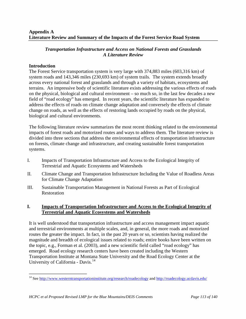
HCPC et al Proposed Revised LMP for the Blue Mountains/DEIS Comments Page 113 of 140
Appendix A Literature Review and Summary of the Impacts of the Forest Service Road System
Transportation Infrastructure and Access on National Forests and Grasslands A Literature Review
Introduction The Forest Service transportation system is very large with 374,883 miles (603,316 km) of system roads and 143,346 miles (230,693 km) of system trails. The system extends broadly across every national forest and grasslands and through a variety of habitats, ecosystems and terrains. An impressive body of scientific literature exists addressing the various effects of roads on the physical, biological and cultural environment – so much so, in the last few decades a new field of “road ecology” has emerged. In recent years, the scientific literature has expanded to address the effects of roads on climate change adaptation and conversely the effects of climate change on roads, as well as the effects of restoring lands occupied by roads on the physical, biological and cultural environments. The following literature review summarizes the most recent thinking related to the environmental impacts of forest roads and motorized routes and ways to address them. The literature review is divided into three sections that address the environmental effects of transportation infrastructure on forests, climate change and infrastructure, and creating sustainable forest transportation systems.
I. Impacts of Transportation Infrastructure and Access to the Ecological Integrity of Terrestrial and Aquatic Ecosystems and Watersheds
II. Climate Change and Transportation Infrastructure Including the Value of Roadless Areas for Climate Change Adaptation
III. Sustainable Transportation Management in National Forests as Part of Ecological Restoration
I. Impacts of Transportation Infrastructure and Access to the Ecological Integrity of
Terrestrial and Aquatic Ecosystems and Watersheds It is well understood that transportation infrastructure and access management impact aquatic and terrestrial environments at multiple scales, and, in general, the more roads and motorized routes the greater the impact. In fact, in the past 20 years or so, scientists having realized the magnitude and breadth of ecological issues related to roads; entire books have been written on the topic, e.g., Forman et al. (2003), and a new scientific field called “road ecology” has emerged. Road ecology research centers have been created including the Western Transportation Institute at Montana State University and the Road Ecology Center at the University of California - Davis.14 14 See http://www.westerntransportationinstitute.org/research/roadecology and http://roadecology.ucdavis.edu/
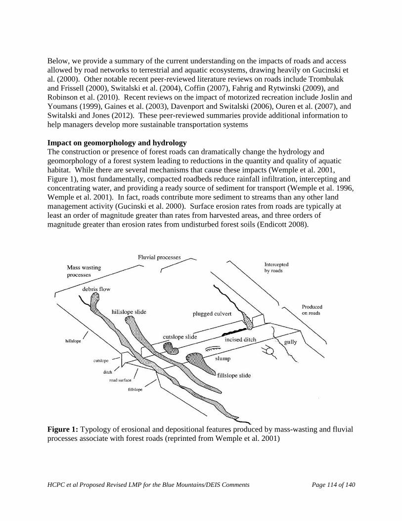
HCPC et al Proposed Revised LMP for the Blue Mountains/DEIS Comments Page 114 of 140
Below, we provide a summary of the current understanding on the impacts of roads and access allowed by road networks to terrestrial and aquatic ecosystems, drawing heavily on Gucinski et al. (2000). Other notable recent peer-reviewed literature reviews on roads include Trombulak and Frissell (2000), Switalski et al. (2004), Coffin (2007), Fahrig and Rytwinski (2009), and Robinson et al. (2010). Recent reviews on the impact of motorized recreation include Joslin and Youmans (1999), Gaines et al. (2003), Davenport and Switalski (2006), Ouren et al. (2007), and Switalski and Jones (2012). These peer-reviewed summaries provide additional information to help managers develop more sustainable transportation systems Impact on geomorphology and hydrology The construction or presence of forest roads can dramatically change the hydrology and geomorphology of a forest system leading to reductions in the quantity and quality of aquatic habitat. While there are several mechanisms that cause these impacts (Wemple et al. 2001, Figure 1), most fundamentally, compacted roadbeds reduce rainfall infiltration, intercepting and concentrating water, and providing a ready source of sediment for transport (Wemple et al. 1996, Wemple et al. 2001). In fact, roads contribute more sediment to streams than any other land management activity (Gucinski et al. 2000). Surface erosion rates from roads are typically at least an order of magnitude greater than rates from harvested areas, and three orders of magnitude greater than erosion rates from undisturbed forest soils (Endicott 2008).
Figure 1: Typology of erosional and depositional features produced by mass-wasting and fluvial processes associate with forest roads (reprinted from Wemple et al. 2001)
HCPC et al Proposed Revised LMP for the Blue Mountains/DEIS Comments Page 115 of 140
Erosion of sediment from roads occurs both chronically and catastrophically. Every time it rains, sediment from the road surface and from cut- and fill-slopes is picked up by rainwater that flows into and on roads (fluvial erosion). The sediment that is entrained in surface flows are often concentrated into road ditches and culverts and directed into streams. The degree of fluvial erosion varies by geology and geography, and increases with increased motorized use (Robichaud et al. 2010). Closed roads produce less sediment, and Foltz et al. (2009) found a significant increase in erosion when closed roads were opened and driven upon. Roads also precipitate catastrophic failures of road beds and fills (mass wasting) during large storm events leading to massive slugs of sediment moving into waterways (Endicott 2008; Gucinski et al. 2000). This typically occurs when culverts are undersized and cannot handle the volume of water, or they simply become plugged with debris. The saturated roadbed can fail entirely and result in a landslide, or the blocked stream crossing can erode the entire fill down to the original stream channel. The erosion of road- and trail-related sediment and its subsequent movement into stream systems affects the geomorphology of the drainage system in a number of ways. The magnitude of their effects varies by climate, geology, road age, construction / maintenance practices and storm history. It directly alters channel morphology by embedding larger gravels as well as filling pools. It can also have the opposite effect of increasing peak discharges and scouring channels, which can lead to disconnection of the channel and floodplain, and lowered base flows (Furniss et al. 1991; Joslin and Youmans 1999). The width/depth ratio of the stream changes which then can trigger changes in water temperature, sinuosity and other geomorphic factors important for aquatic species survival (Joslin and Youmans 1999; Trombulak and Frissell 2000). Roads also can modify flowpaths in the larger drainage network. Roads intercept subsurface flow as well as concentrate surface flow, which results in new flowpaths that otherwise would not exist, and the extension of the drainage network into previously unchannelized portions of the hillslope (Gucinski et al. 2000; Joslin and Youmans 1999). Severe aggradation of sediment at stream structures or confluences can force streams to actually go subsurface or make them too shallow for fish passage (Endicott 2008; Furniss et al. 1991). Impacts on aquatic habitat and fish Roads can have dramatic and lasting impacts on fish and aquatic habitat. Increased sedimentation in stream beds has been linked to decreased fry emergence, decreased juvenile densities, loss of winter carrying capacity, and increased predation of fishes, and reductions in macro-invertebrate populations that are a food source to many fish species (Rhodes et al. 1994, Joslin and Youmans 1999, Gucinski et al. 2000, Endicott 2008). On a landscape scale, these effects can add up to: changes in the frequency, timing and magnitude of disturbance to aquatic habitat and changes to aquatic habitat structures (e.g., pools, riffles, spawning gravels and in-channel debris), and conditions (food sources, refugi, and water temperature) (Gucinski et al. 2000). Roads can also act as barriers to migration (Gucinski et al. 2000). Where roads cross streams, road engineers usually place culverts or bridges. Culverts in particular can and often interfere with sediment transport and channel processes such that the road/stream crossing becomes a
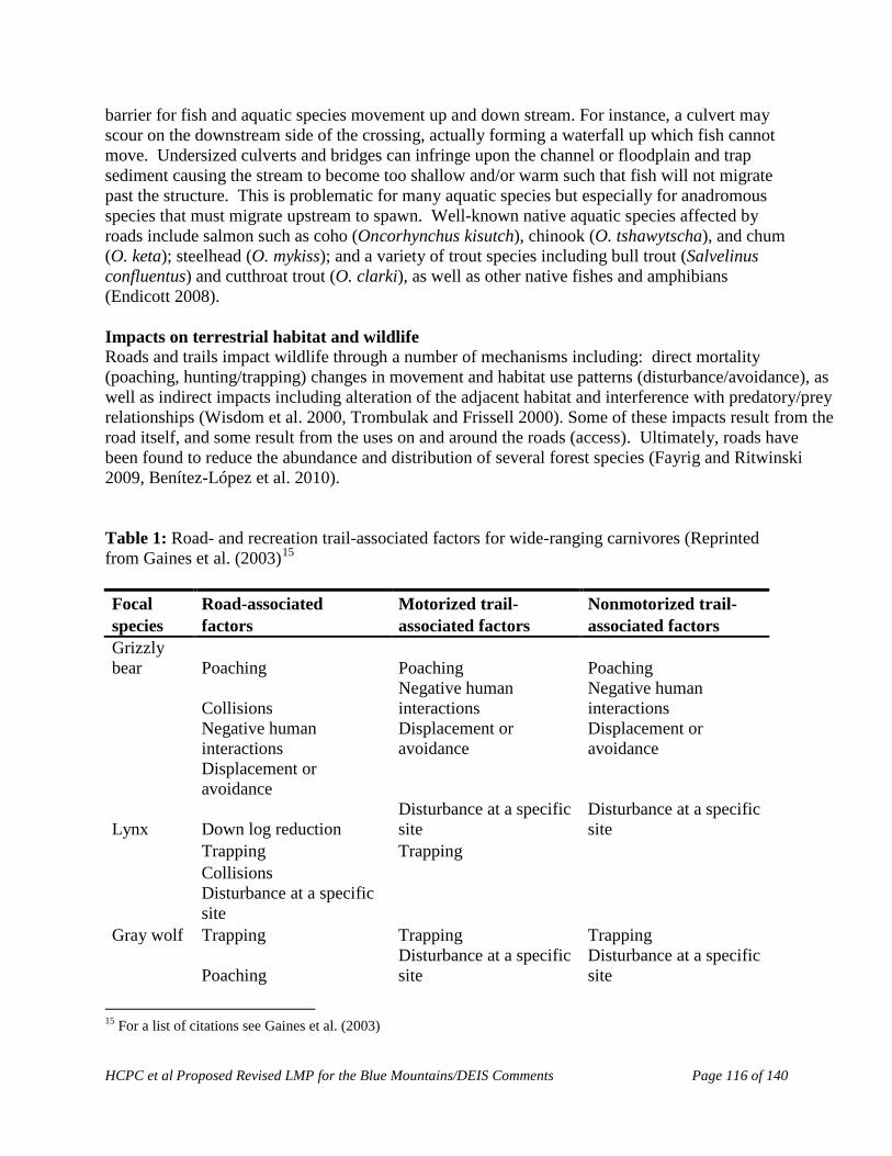
HCPC et al Proposed Revised LMP for the Blue Mountains/DEIS Comments Page 116 of 140
barrier for fish and aquatic species movement up and down stream. For instance, a culvert may scour on the downstream side of the crossing, actually forming a waterfall up which fish cannot move. Undersized culverts and bridges can infringe upon the channel or floodplain and trap sediment causing the stream to become too shallow and/or warm such that fish will not migrate past the structure. This is problematic for many aquatic species but especially for anadromous species that must migrate upstream to spawn. Well-known native aquatic species affected by roads include salmon such as coho (Oncorhynchus kisutch), chinook (O. tshawytscha), and chum (O. keta); steelhead (O. mykiss); and a variety of trout species including bull trout (Salvelinus confluentus) and cutthroat trout (O. clarki), as well as other native fishes and amphibians (Endicott 2008). Impacts on terrestrial habitat and wildlife Roads and trails impact wildlife through a number of mechanisms including: direct mortality (poaching, hunting/trapping) changes in movement and habitat use patterns (disturbance/avoidance), as well as indirect impacts including alteration of the adjacent habitat and interference with predatory/prey relationships (Wisdom et al. 2000, Trombulak and Frissell 2000). Some of these impacts result from the road itself, and some result from the uses on and around the roads (access). Ultimately, roads have been found to reduce the abundance and distribution of several forest species (Fayrig and Ritwinski 2009, Benítez-López et al. 2010). Table 1: Road- and recreation trail-associated factors for wide-ranging carnivores (Reprinted from Gaines et al. (2003)15 Focal Road-associated Motorized trail- Nonmotorized trail- species factors associated factors associated factors Grizzly bear Poaching Poaching Poaching
Collisions Negative human interactions
Negative human interactions
Negative human interactions
Displacement or avoidance
Displacement or avoidance
Displacement or avoidance
Lynx Down log reduction Disturbance at a specific site
Disturbance at a specific site
Trapping Trapping Collisions
Disturbance at a specific site
Gray wolf Trapping Trapping Trapping
Poaching Disturbance at a specific site
Disturbance at a specific site
15 For a list of citations see Gaines et al. (2003)
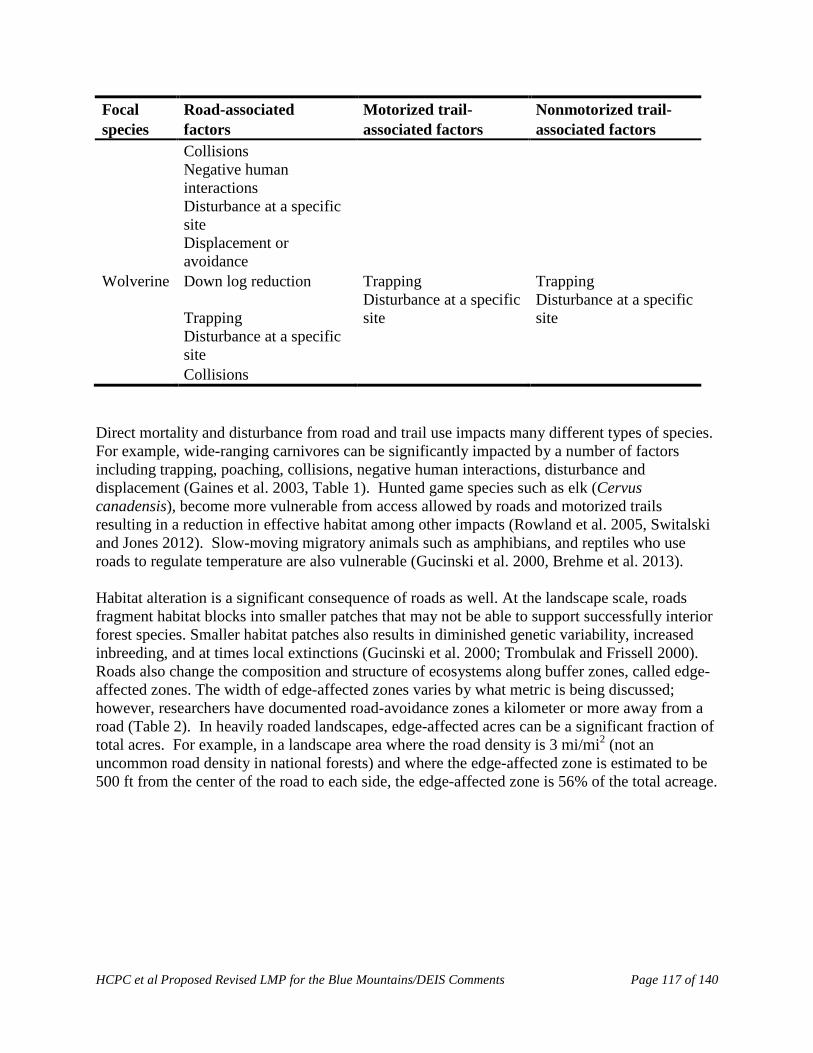
HCPC et al Proposed Revised LMP for the Blue Mountains/DEIS Comments Page 117 of 140
Focal Road-associated Motorized trail- Nonmotorized trail- species factors associated factors associated factors Collisions
Negative human interactions
Disturbance at a specific site
Displacement or avoidance
Wolverine Down log reduction Trapping Trapping
Trapping Disturbance at a specific site
Disturbance at a specific site
Disturbance at a specific site
Collisions Direct mortality and disturbance from road and trail use impacts many different types of species. For example, wide-ranging carnivores can be significantly impacted by a number of factors including trapping, poaching, collisions, negative human interactions, disturbance and displacement (Gaines et al. 2003, Table 1). Hunted game species such as elk (Cervus canadensis), become more vulnerable from access allowed by roads and motorized trails resulting in a reduction in effective habitat among other impacts (Rowland et al. 2005, Switalski and Jones 2012). Slow-moving migratory animals such as amphibians, and reptiles who use roads to regulate temperature are also vulnerable (Gucinski et al. 2000, Brehme et al. 2013). Habitat alteration is a significant consequence of roads as well. At the landscape scale, roads fragment habitat blocks into smaller patches that may not be able to support successfully interior forest species. Smaller habitat patches also results in diminished genetic variability, increased inbreeding, and at times local extinctions (Gucinski et al. 2000; Trombulak and Frissell 2000). Roads also change the composition and structure of ecosystems along buffer zones, called edge-affected zones. The width of edge-affected zones varies by what metric is being discussed; however, researchers have documented road-avoidance zones a kilometer or more away from a road (Table 2). In heavily roaded landscapes, edge-affected acres can be a significant fraction of total acres. For example, in a landscape area where the road density is 3 mi/mi2 (not an uncommon road density in national forests) and where the edge-affected zone is estimated to be 500 ft from the center of the road to each side, the edge-affected zone is 56% of the total acreage.
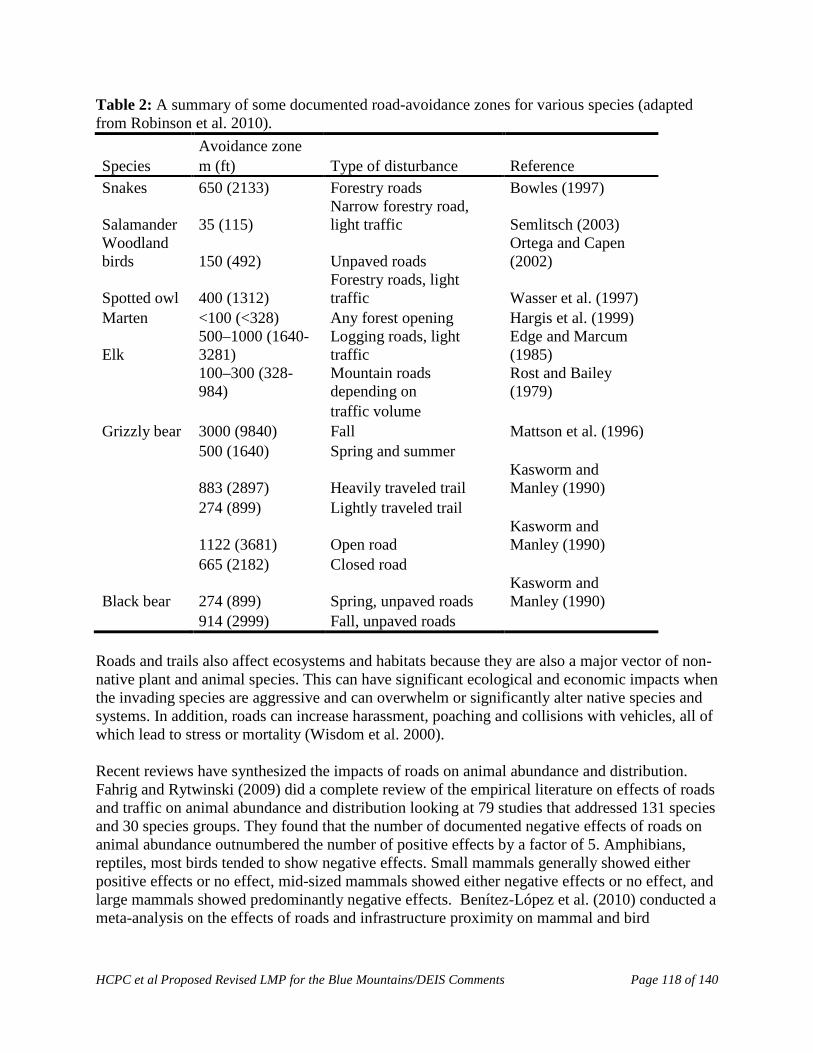
HCPC et al Proposed Revised LMP for the Blue Mountains/DEIS Comments Page 118 of 140
Table 2: A summary of some documented road-avoidance zones for various species (adapted from Robinson et al. 2010). Avoidance zone Species m (ft) Type of disturbance Reference Snakes 650 (2133) Forestry roads Bowles (1997)
Salamander 35 (115) Narrow forestry road, light traffic Semlitsch (2003)
Woodland birds 150 (492) Unpaved roads
Ortega and Capen (2002)
Spotted owl 400 (1312) Forestry roads, light traffic Wasser et al. (1997)
Marten <100 (<328) Any forest opening Hargis et al. (1999)
Elk 500–1000 (1640-3281)
Logging roads, light traffic
Edge and Marcum (1985)
100–300 (328-984)
Mountain roads depending on
Rost and Bailey (1979)
traffic volume Grizzly bear 3000 (9840) Fall Mattson et al. (1996) 500 (1640) Spring and summer
883 (2897) Heavily traveled trail Kasworm and Manley (1990)
274 (899) Lightly traveled trail
1122 (3681) Open road Kasworm and Manley (1990)
665 (2182) Closed road
Black bear 274 (899) Spring, unpaved roads Kasworm and Manley (1990)
914 (2999) Fall, unpaved roads Roads and trails also affect ecosystems and habitats because they are also a major vector of non-native plant and animal species. This can have significant ecological and economic impacts when the invading species are aggressive and can overwhelm or significantly alter native species and systems. In addition, roads can increase harassment, poaching and collisions with vehicles, all of which lead to stress or mortality (Wisdom et al. 2000). Recent reviews have synthesized the impacts of roads on animal abundance and distribution. Fahrig and Rytwinski (2009) did a complete review of the empirical literature on effects of roads and traffic on animal abundance and distribution looking at 79 studies that addressed 131 species and 30 species groups. They found that the number of documented negative effects of roads on animal abundance outnumbered the number of positive effects by a factor of 5. Amphibians, reptiles, most birds tended to show negative effects. Small mammals generally showed either positive effects or no effect, mid-sized mammals showed either negative effects or no effect, and large mammals showed predominantly negative effects. Benítez-López et al. (2010) conducted a meta-analysis on the effects of roads and infrastructure proximity on mammal and bird

HCPC et al Proposed Revised LMP for the Blue Mountains/DEIS Comments Page 119 of 140
populations. They found a significant pattern of avoidance and a reduction in bird and mammal populations in the vicinity of infrastructure. Road density16 thresholds for fish and wildlife It is well documented that beyond specific road density thresholds, certain species will be negatively affected, and some will be extirpated. Most studies that look into the relationship between road density and wildlife focus on the impacts to large endangered carnivores or hunted game species, although high road densities certainly affect other species – for instance, reptiles and amphibians. Gray wolves (Canis lupus) in the Great Lakes region and elk in Montana and Idaho have undergone the most long-term and in depth analysis. Forman and Hersperger (1996) found that in order to maintain a naturally functioning landscape with sustained populations of large mammals, road density must be below 0.6 km/km² (1.0 mi/mi²). Several studies have since substantiated their claim (Robinson et al. 2010, Table 3). A number of studies at broad scales have also shown that higher road densities generally lead to greater impacts to aquatic habitats and fish density (Table 3). Carnefix and Frissell (2009) provide a concise review of studies that correlate cold water fish abundance and road density, and from the cited evidence concluded that “1) no truly “safe” threshold road density exists, but rather negative impacts begin to accrue and be expressed with incursion of the very first road segment; and 2) highly significant impacts (e.g., threat of extirpation of sensitive species) are already apparent at road densities on the order of 0.6 km/km2 (1.0 mi/mi²) or less” (p. 1) Table 3: A summary of some road-density thresholds and correlations for terrestrial and aquatic species and ecosystems (reprinted from Robinson et al. 2010).
Species (Location) Road density (mean, guideline, threshold, correlation) Reference Wolf (Minnesota) 0.36 km/km2 (mean road density in primary range); Mech et al. (1988) 0.54 km/km2 (mean road density in peripheral range) Wolf >0.6 km/km2 (absent at this density) Jalkotzy et al. (1997) Wolf (Northern Great Lakes re- >0.45 km/km2 (few packs exist above this threshold); Mladenoff et al. (1995) gion) >1.0 km/km2 (no pack exist above this threshold) Wolf (Wisconsin) 0.63 km/km2 (increasing due to greater human tolerance Wydeven et al. (2001) Wolf, mountain lion (Minne- 0.6 km/km2 (apparent threshold value for a naturally Thiel (1985); van Dyke et sota, Wisconsin, Michigan) functioning landscape containing sustained popula- al. (1986); Jensen et al. tions) (1986); Mech et al. (1988); Mech (1989) Elk (Idaho) 1.9 km/km2 (density standard for habitat effectiveness) Woodley 2000 cited in Beazley et al. 2004 Elk (Northern US) 1.24 km/km2 (habitat effectiveness decline by at least Lyon (1983) 50%) Elk, bear, wolverine, lynx, and 0.63 km/km2 (reduced habitat security and increased Wisdom et al. (2000)
16 We intend the term “road density” to refer to the density all roads within national forests, including system roads, closed roads, non-system roads administered by other jurisdictions (private, county, state), temporary roads and motorized trails. Please see Attachment 2 for the relevant existing scientific information supporting this approach.

HCPC et al Proposed Revised LMP for the Blue Mountains/DEIS Comments Page 120 of 140
Species (Location) Road density (mean, guideline, threshold, correlation) Reference others mortality) Moose (Ontario) 0.2-0.4 km/km2 (threshold for pronounced response) Beyer et al. (2013) Grizzly bear (Montana) >0.6 km/km2 Mace et al. (1996); Matt- son et al. (1996) Black bear (North Carolina) >1.25 km/km2 (open roads); >0.5 km/km2 (logging Brody and Pelton (1989) roads); (interference with use of habitat) Black bear 0.25 km/km2 (road density should not exceed) Jalkotzy et al. (1997) Bobcat (Wisconsin) 1.5 km/km2 (density of all road types in home range) Jalkotzy et al. (1997) Large mammals >0.6 km/km2 (apparent threshold value for a naturally Forman and Hersperger functioning landscape containing sustained popula- (1996) tions) Bull trout (Montana) Inverse relationship of population and road density Rieman et al. (1997); Baxter et al. (1999) Fish populations (Medicine Bow (1) Positive correlation of numbers of culverts and Eaglin and Hubert (1993) National Forest) stream crossings and amount of fine sediment in cited in Gucinski et al. stream channels (2001) (2) Negative correlation of fish density and numbers of culverts Macroinvertebrates Species richness negatively correlated with an index of McGurk and Fong (1995) road density Non-anadromous salmonids (1) Negative correlation likelihood of spawning and Lee et al. (1997) (Upper Columbia River basin) rearing and road density (2) Negative correlation of fish density and road density
Where both stream and road densities are high, the incidence of connections between roads and streams can also be expected to be high, resulting in more common and pronounced effects of roads on streams (Gucinski et al. 2000). For example, a study on the Medicine Bow National Forest (WY) found as the number of culverts and stream crossings increased, so did the amount of sediment in stream channels (Eaglin and Hubert 1993). They also found a negative correlation with fish density and the number of culverts. Invertebrate communities can also be impacted. McGurk and Fong (1995) report a negative correlation between an index of road density with macroinvertebrate diversity. The U.S. Fish and Wildlife Service’s Final Rule listing bull trout as threatened (USDI Fish and Wildlife Service 1999) addressed road density, stating:
“… assessment of the interior Columbia Basin ecosystem revealed that increasing road densities were associated with declines in four non-anadromous salmonid species (bull trout, Yellowstone cutthroat trout, westslope cutthroat trout, and redband trout) within the Columbia River Basin, likely through a variety of factors associated with roads (Quigley & Arbelbide 1997). Bull trout were less likely to use highly roaded basins for spawning and rearing, and if present, were likely to be at lower population levels (Quigley and Arbelbide 1997). Quigley et al. (1996) demonstrated that when average road densities
HCPC et al Proposed Revised LMP for the Blue Mountains/DEIS Comments Page 121 of 140
were between 0.4 to 1.1 km/km2 (0.7 and 1.7 mi/mi2) on USFS lands, the proportion of subwatersheds supporting “strong” populations of key salmonids dropped substantially. Higher road densities were associated with further declines” (USDI Fish and Wildlife Service 1999, p. 58922).
Anderson et al. (2012) also showed that watershed conditions tend to be best in areas protected from road construction and development. Using the US Forest Service’s Watershed Condition Framework assessment data, they showed that National Forest lands that are protected under the Wilderness Act, which provides the strongest safeguards, tend to have the healthiest watersheds. Watersheds in Inventoried Roadless Areas – which are protected from road building and logging by the Roadless Area Conservation Rule – tend to be less healthy than watersheds in designated Wilderness, but they are considerably healthier than watersheds in the managed landscape. Impacts on other resources Roads and motorized trails also play a role in affecting wildfire occurrence. Research shows that human-ignited wildfires, which account for more than 90% of fires on national lands, is almost five times more likely in areas with roads (USDA Forest Service 1996a; USDA Forest Service 1998). Furthermore, Baxter (2002) found that off-road vehicles (ORVs) can be a significant source of fire ignitions on forestlands. Roads can affect where and how forests burn and, by extension, the vegetative condition of the forest. See Attachment 1 for more information documenting the relationship between roads and wildfire occurrence. Finally, access allowed by roads and trails can increase of ORV and motorized use in remote areas threatening archaeological and historic sites. Increased visitation has resulted in intentional and unintentional damage to many cultural sites (USDI Bureau of Land Management 2000, Schiffman 2005).
II. Climate Change and Transportation Infrastructure including the value of roadless areas for climate change adaptation
As climate change impacts grow more profound, forest managers must consider the impacts on the transportation system as well as from the transportation system. In terms of the former, changes in precipitation and hydrologic patterns will strain infrastructure at times to the breaking point resulting in damage to streams, fish habitat, and water quality as well as threats to public safety. In terms of the latter, the fragmenting effect of roads on habitat will impede the movement of species which is a fundamental element of adaptation. Through planning, forest managers can proactively address threats to infrastructure, and can actually enhance forest resilience by removing unneeded roads to create larger patches of connected habitat. Impact of climate change and roads on transportation infrastructure It is expected that climate change will be responsible for more extreme weather events, leading to increasing flood severity, more frequent landslides, changing hydrographs (peak, annual mean flows, etc.), and changes in erosion and sedimentation rates and delivery processes. Roads and trails in national forests, if designed by an engineering standard at all, were designed for storms and water flows typical of past decades, and hence may not be designed for the storms in future
HCPC et al Proposed Revised LMP for the Blue Mountains/DEIS Comments Page 122 of 140
decades. Hence, climate driven changes may cause transportation infrastructure to malfunction or fail (ASHTO 2012, USDA Forest Service 2010). The likelihood is higher for facilities in high-risk settings—such as rain-on-snow zones, coastal areas, and landscapes with unstable geology (USDA Forest Service 2010). Forests fragmented by roads will likely demonstrate less resistance and resilience to stressors, like those associated with climate change (Noss 2001). First, the more a forest is fragmented (and therefore the higher the edge/interior ratio), the more the forest loses its inertia characteristic, and becoming less resilient and resistant to climate change. Second, the more a forest is fragmented characterized by isolated patches, the more likely the fragmentation will interfere with the ability of species to track shifting climatic conditions over time and space. Noss (2001) predicts that weedy species with effective dispersal mechanisms might benefit from fragmentation at the expense of native species. Modifying infrastructure to increase resilience To prevent or reduce road failures, culvert blow-outs, and other associated hazards, forest managers will need to take a series of actions. These include replacing undersized culverts with larger ones, prioritizing maintenance and upgrades (e.g., installing drivable dips and more outflow structures), and obliterating roads that are no longer needed and pose erosion hazards (USDA Forest Service 2010, USDA Forest Service 2012a, USDA Forest Service 2011, Table 4). Olympic National Forest has developed a number of documents oriented at oriented at protecting watershed health and species in the face of climate change, including a 2003 travel management strategy and a report entitled Adapting to Climate Change in Olympic National Park and National Forest. In the travel management strategy, Olympic National Forest recommended that 1/3rd of its road system be decommissioned and obliterated (USDA Forest Service 2011a). In addition, the plan called for addressing fish migration barriers in a prioritized and strategic way – most of these are associated with roads. The report calls for road decommissioning, relocation of roads away from streams, enlarging culverts as well as replacing culverts with fish-friendly crossings (USDA Forest Service 2011a, Table 4). Table 4: Current and expected sensitivities of fish to climate change on the Olympic Peninsula, associated adaptation strategies and action for fisheries and fish habitat management and relevant to transportation management at Olympic National Forest and Olympic National Park (excerpt reprinted from USDA Forest Service 2011a). Current and expected sensitivities Adaptation strategies and actions Changes in habitat quantity and quality
• Implement habitat restoration projects that focus on re-creating
watershed processes and functions and that create diverse,
resilient habitat. Increase in culvert failures, fill-slope failures,
• Decommission unneeded roads.
stream adjacent road failures, and encroach-
• Remove sidecast, improve drainage, and increase culvert sizing
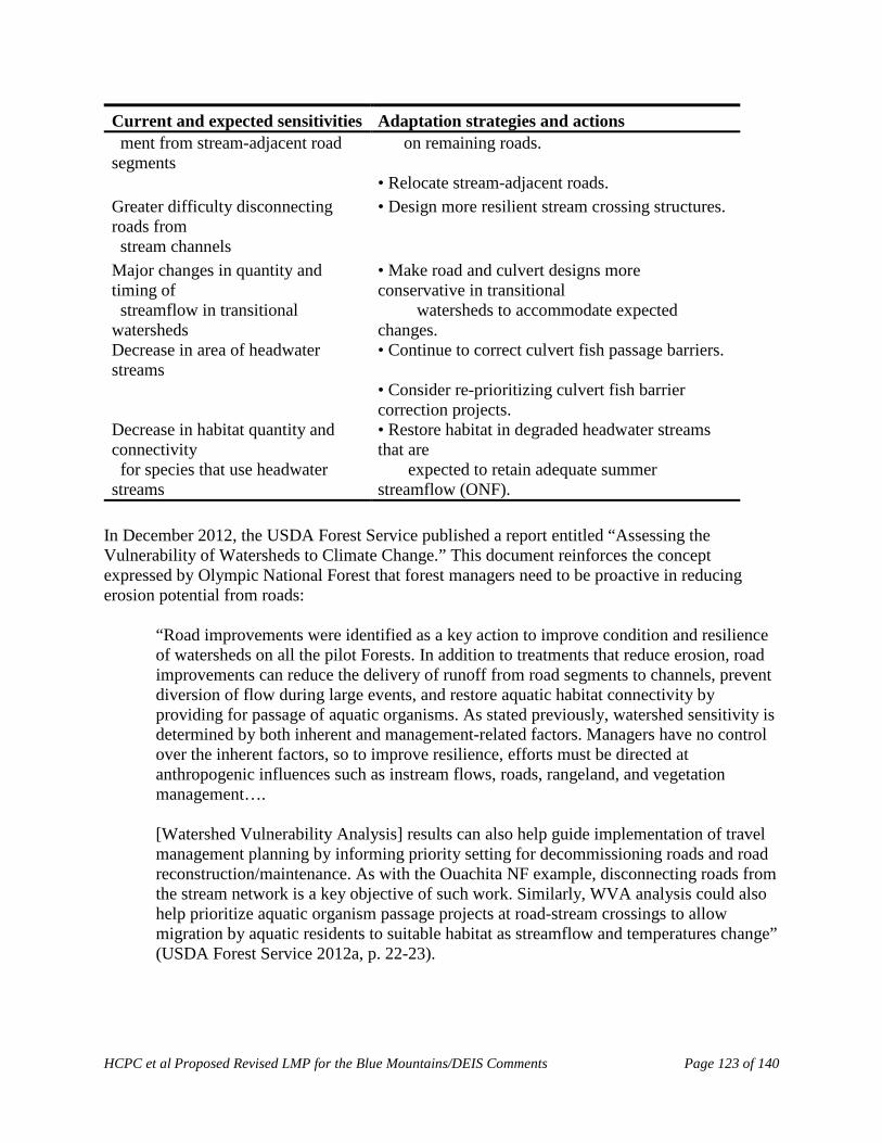
HCPC et al Proposed Revised LMP for the Blue Mountains/DEIS Comments Page 123 of 140
Current and expected sensitivities Adaptation strategies and actions ment from stream-adjacent road segments
on remaining roads.
• Relocate stream-adjacent roads. Greater difficulty disconnecting roads from
• Design more resilient stream crossing structures.
stream channels Major changes in quantity and timing of
• Make road and culvert designs more conservative in transitional
streamflow in transitional watersheds
watersheds to accommodate expected changes.
Decrease in area of headwater streams
• Continue to correct culvert fish passage barriers.
• Consider re-prioritizing culvert fish barrier correction projects.
Decrease in habitat quantity and connectivity
• Restore habitat in degraded headwater streams that are
for species that use headwater streams
expected to retain adequate summer streamflow (ONF).
In December 2012, the USDA Forest Service published a report entitled “Assessing the Vulnerability of Watersheds to Climate Change.” This document reinforces the concept expressed by Olympic National Forest that forest managers need to be proactive in reducing erosion potential from roads:
“Road improvements were identified as a key action to improve condition and resilience of watersheds on all the pilot Forests. In addition to treatments that reduce erosion, road improvements can reduce the delivery of runoff from road segments to channels, prevent diversion of flow during large events, and restore aquatic habitat connectivity by providing for passage of aquatic organisms. As stated previously, watershed sensitivity is determined by both inherent and management-related factors. Managers have no control over the inherent factors, so to improve resilience, efforts must be directed at anthropogenic influences such as instream flows, roads, rangeland, and vegetation management….
[Watershed Vulnerability Analysis] results can also help guide implementation of travel management planning by informing priority setting for decommissioning roads and road reconstruction/maintenance. As with the Ouachita NF example, disconnecting roads from the stream network is a key objective of such work. Similarly, WVA analysis could also help prioritize aquatic organism passage projects at road-stream crossings to allow migration by aquatic residents to suitable habitat as streamflow and temperatures change” (USDA Forest Service 2012a, p. 22-23).
HCPC et al Proposed Revised LMP for the Blue Mountains/DEIS Comments Page 124 of 140
Reducing fragmentation to enhance aquatic and terrestrial species adaptation Decommissioning and upgrading roads and thus reducing the amount of fine sediment deposited on salmonid nests can increase the likelihood of egg survival and spawning success (McCaffery et al. 2007). In addition, this would reconnect stream channels and remove barriers such as culverts. Decommissioning roads in riparian areas may provide further benefits to salmon and other aquatic organisms by permitting reestablishment of streamside vegetation, which provides shade and maintains a cooler, more moderated microclimate over the stream (Battin et al. 2007). One of the most well documented impacts of climate change on wildlife is a shift in the ranges of species (Parmesan 2006). As animals migrate, landscape connectivity will be increasingly important (Holman et al. 2005). Decommissioning roads in key wildlife corridors will improve connectivity and be an important mitigation measure to increase resiliency of wildlife to climate change. For wildlife, road decommissioning can reduce the many stressors associated with roads. Road decommissioning restores habitat by providing security and food such as grasses and fruiting shrubs for wildlife (Switalski and Nelson 2011). Forests fragmented by roads and motorized trail networks will likely demonstrate less resistance and resilience to stressors, such as weeds. As a forest is fragmented and there is more edge habitat, Noss (2001) predicts that weedy species with effective dispersal mechanisms will increasingly benefit at the expense of native species. However, decommissioned roads when seeded with native species can reduce the spread of invasive species (Grant et al. 2011), and help restore fragmented forestlands. Off-road vehicles with large knobby tires and large undercarriages are also a key vector for weed spread (e.g., Rooney 2006). Strategically closing and decommissioning motorized routes, especially in roadless areas, will reduce the spread of weeds on forestlands (Gelbard and Harrison 2003). Transportation infrastructure and carbon sequestration The topic of the relationship of road restoration and carbon has only recently been explored. There is the potential for large amounts of carbon (C) to be sequestered by reclaiming roads. When roads are decompacted during reclamation, vegetation and soils can develop more rapidly and sequester large amounts of carbon. A recent study estimated total soil C storage increased 6 fold to 6.5 x 10⁷g C/km (to 25 cm depth) in the northwestern US compared to untreated abandoned roads (Lloyd et al. 2013). Another recent study concluded that reclaiming 425 km of logging roads over the last 30 years in Redwood National Park in Northern California resulted in net carbon savings of 49,000 Mg carbon to date (Madej et al. 2013, Table 5). Kerekvliet et al. (2008) published a Wilderness Society briefing memo on the impact to carbon sequestration from road decommissioning. Using Forest Service estimates of the fraction of road miles that are unneeded, the authors calculated that restoring 126,000 miles of roads to a natural state would be equivalent to revegetating an area larger than Rhode Island. In addition, they calculate that the net economic benefit of road treatments are always positive and range from US$0.925-1.444 billion.
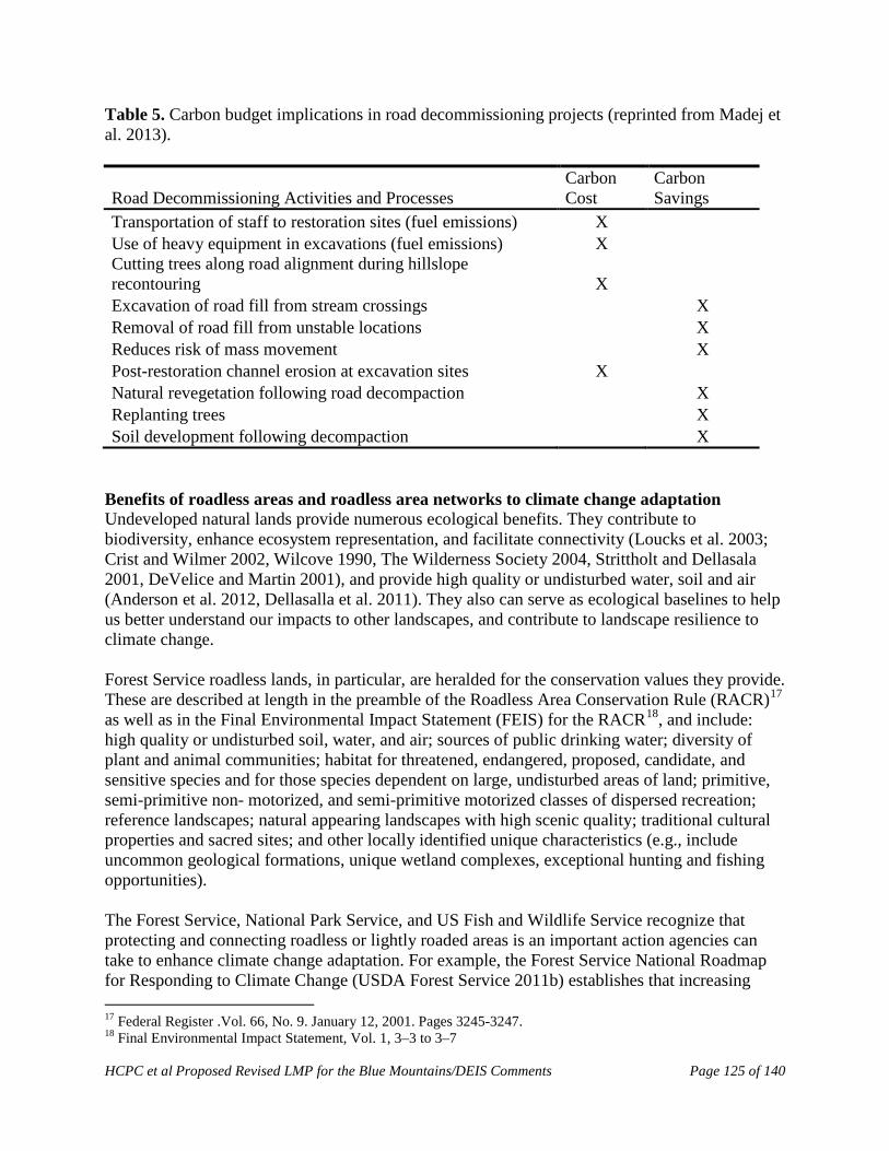
HCPC et al Proposed Revised LMP for the Blue Mountains/DEIS Comments Page 125 of 140
Table 5. Carbon budget implications in road decommissioning projects (reprinted from Madej et al. 2013).
Road Decommissioning Activities and Processes Carbon Cost
Carbon Savings
Transportation of staff to restoration sites (fuel emissions) X Use of heavy equipment in excavations (fuel emissions) X Cutting trees along road alignment during hillslope recontouring X Excavation of road fill from stream crossings X Removal of road fill from unstable locations X Reduces risk of mass movement X Post-restoration channel erosion at excavation sites X Natural revegetation following road decompaction X Replanting trees X Soil development following decompaction X
Benefits of roadless areas and roadless area networks to climate change adaptation Undeveloped natural lands provide numerous ecological benefits. They contribute to biodiversity, enhance ecosystem representation, and facilitate connectivity (Loucks et al. 2003; Crist and Wilmer 2002, Wilcove 1990, The Wilderness Society 2004, Strittholt and Dellasala 2001, DeVelice and Martin 2001), and provide high quality or undisturbed water, soil and air (Anderson et al. 2012, Dellasalla et al. 2011). They also can serve as ecological baselines to help us better understand our impacts to other landscapes, and contribute to landscape resilience to climate change.
Forest Service roadless lands, in particular, are heralded for the conservation values they provide. These are described at length in the preamble of the Roadless Area Conservation Rule (RACR)17 as well as in the Final Environmental Impact Statement (FEIS) for the RACR18, and include: high quality or undisturbed soil, water, and air; sources of public drinking water; diversity of plant and animal communities; habitat for threatened, endangered, proposed, candidate, and sensitive species and for those species dependent on large, undisturbed areas of land; primitive, semi-primitive non- motorized, and semi-primitive motorized classes of dispersed recreation; reference landscapes; natural appearing landscapes with high scenic quality; traditional cultural properties and sacred sites; and other locally identified unique characteristics (e.g., include uncommon geological formations, unique wetland complexes, exceptional hunting and fishing opportunities). The Forest Service, National Park Service, and US Fish and Wildlife Service recognize that protecting and connecting roadless or lightly roaded areas is an important action agencies can take to enhance climate change adaptation. For example, the Forest Service National Roadmap for Responding to Climate Change (USDA Forest Service 2011b) establishes that increasing 17 Federal Register .Vol. 66, No. 9. January 12, 2001. Pages 3245-3247. 18 Final Environmental Impact Statement, Vol. 1, 3–3 to 3–7

HCPC et al Proposed Revised LMP for the Blue Mountains/DEIS Comments Page 126 of 140
connectivity and reducing fragmentation are short and long term actions the Forest Service should take to facilitate adaptation to climate change.19 The National Park Service also identifies connectivity as a key factor for climate change adaptation along with establishing “blocks of natural landscape large enough to be resilient to large-scale disturbances and long-term changes” and other factors. The agency states that: “The success of adaptation strategies will be enhanced by taking a broad approach that identifies connections and barriers across the landscape. Networks of protected areas within a larger mixed landscape can provide the highest level of resilience to climate change.”20 Similarly, the National Fish, Wildlife and Plants Climate Adaptation Partnership’s Adaptation Strategy (2012) calls for creating an ecologically-connected network of conservation areas.21 Crist and Wilmer (2002) looked at the ecological value of roadless lands in the Northern Rockies and found that protection of national forest roadless areas, when added to existing federal conservation lands in the study area, would 1) increase the representation of virtually all land cover types on conservation lands at both the regional and ecosystem scales, some by more than 100%; 2) help protect rare, species-rich, and often-declining vegetation communities; and 3) connect conservation units to create bigger and more cohesive habitat “patches.” Roadless lands also are responsible for higher quality water and watersheds. Anderson et al. (2012) assessed the relationship of watershed condition and land management status and found a strong spatial association between watershed health and protective designations. Dellasalla et al. (2011) found that undeveloped and roadless watersheds are important for supplying downstream users with high-quality drinking water, and developing these watersheds comes at significant costs associated with declining water quality and availability. The authors recommend a light-touch ecological footprint to sustain the many values that derive from roadless areas including healthy watersheds. 19 Forest Service, 2011. National Roadmap for Responding to Climate Change. US Department of Agriculture. FS-957b. Page 26. 20 National Park Service. Climate Change Response Program Brief. http://www.nature.nps.gov/climatechange/adaptationplanning.cfm. Also see: National Park Service, 2010. Climate Change Response Strategy. http://www.nature.nps.gov/climatechange/docs/NPS_CCRS.pdf. Objective 6.3 is to “Collaborate to develop cross-jurisdictional conservation plans to protect and restore connectivity and other landscape-scale components of resilience.” 21 See http://www.wildlifeadaptationstrategy.gov/pdf/NFWPCAS‐Chapter‐3.pdf. Pages 55- 59. The first goal and related strategies are:
Goal 1: Conserve habitat to support healthy fish, wildlife, and plant populations and ecosystem functions in a changing climate.
Strategy 1.1: identify areas for an ecologically-connected network of terrestrial, freshwater, coastal, and marine conservation areas that are likely to be resilient to climate change and to support a broad range of -fish, wildlife, and plants under changed conditions. Strategy 1.2: Secure appropriate conservation status on areas identified in Strategy 1.1 to complete an ecologically-connected network of public and private conservation areas that will be resilient to climate change and support a broad range of species under changed conditions. Strategy 1.4: Conserve, restore, and as appropriate and practicable, establish new ecological connections among conservation areas to facilitate fish, wildlife, and plant migration, range shifts, and other transitions caused by climate change.
HCPC et al Proposed Revised LMP for the Blue Mountains/DEIS Comments Page 127 of 140
III. Sustainable Transportation Management in National Forests as Part of
Ecological Restoration
At 375,000 miles strong, the Forest Service road system is one of the largest in the world – it is eight times the size of the National Highway System. It is also indisputably unsustainable – that is, roads are not designed, located, or maintained according to best management practices, and environmental impacts are not minimized. It is largely recognized that forest roads, especially unpaved ones, are a primary source of sediment pollution to surface waters (Endicott 2008, Gucinski et al. 2000), and that the system has about 1/3rd more miles than it needs (USDA Forest Service 2001). In addition, the majority of the roads were constructed decades ago when road design and management techniques did not meet current standards (Gucinski et al. 2000, Endicott 2008), making them more vulnerable to erosion and decay than if they had been designed today. Road densities in national forests often exceed accepted thresholds for wildlife. Only a small portion of the road system is regularly used. All but 18% of the road system is inaccessible to passenger vehicles. Fifty-five percent of the roads are accessible only by high clearance vehicles and 27% are closed. The 18% that is accessible to cars is used for about 80% of the trips made within National Forests.22 Most of the road maintenance funding is directed to the passenger car roads, while the remaining roads suffer from neglect. As a result, the Forest Service currently has a $3.7 billion road maintenance backlog that grows every year. In other words, only about 1/5th of the roads in the national forest system are used most of the time, and the fraction that is used often is the best designed and maintained because they are higher level access roads. The remaining roads sit generally unneeded and under-maintained – arguably a growing ecological and fiscal liability. Current Forest Service management direction is to identify and implement a sustainable transportation system.23 The challenge for forest managers is figuring out what is a sustainable road system and how to achieve it – a challenge that is exacerbated by climate change. It is reasonable to define a sustainable transportation system as one where all the routes are constructed, located, and maintained with best management practices, and social and environmental impacts are minimized. This, of course, is easier said than done, since the reality is that even the best roads and trail networks can be problematic simply because they exist and usher in land uses that without the access would not occur (Trombulak and Frissell 2000, Carnefix and Frissell 2009, USDA Forest Service 1996b), and when they are not maintained to the designed level they result in environmental problems (Endicott 2008; Gucinski et al. 2000). Moreover, what was sustainable may no longer be sustainable under climate change since roads designed to meet older climate criteria may no longer hold up under new climate scenarios (USDA Forest Service 2010, USDA Forest Service 2011b, USDA Forest Service 2012a, AASHTO 2012).
22 USDA Forest Service. Road Management Website Q&As. Available online at http://www.fs.fed.us/eng/road_mgt/qanda.shtml. 23 See Forest Service directive memo dated March 29, 2012 entitled “Travel Management, Implementation of 36 CFR, Part 202, Subpart A (36 CFR 212.5(b))”
HCPC et al Proposed Revised LMP for the Blue Mountains/DEIS Comments Page 128 of 140
Forest Service efforts to move toward a more sustainable transportation system The Forest Service has made efforts to make its transportation system more sustainable, but still has considerable work to do. In 2001, the Forest Service tried to address the issue by promulgating the Roads Rule24 with the purpose of working toward a sustainable road system (USDA 2001). The Rule directed every national forest to identify a minimum necessary road system and identify unneeded roads for decommissioning. To do this, the Forest Service developed the Roads Analysis Process (RAP), and published Gucinski et al. (2000) to provide the scientific foundation to complement the RAP. In describing the RAP, Gucinski et al. (2000) writes:
“Roads Analysis is intended to be an integrated, ecological, social, and economic approach to transportation planning. It uses a multiscale approach to ensure that the identified issues are examined in context. Roads Analysis is to be based on science. Analysts are expected to locate, correctly interpret, and use relevant existing scientific literature in the analysis, disclose any assumptions made during the analysis, and reveal the limitations of the information on which the analysis is based. The analysis methods and the report are to be subjected to critical technical review” (p. 10).
Most national forests have completed RAPs, although most only looked at passenger vehicle roads which account for less than 20% of the system’s miles. The Forest Service Washington Office in 2010 directed that forests complete a Travel Analysis Process (TAP) by the end of fiscal year 2015, which must address all roads and create a map and list of roads identifying which are likely needed and which are not. Completed TAPs will provide a blueprint for future road decommissioning and management, they will not constitute compliance with the Roads Rule, which clearly requires the identification of the minimum roads system and roads for decommissioning. Almost all forests have yet to comply with subpart A. The Forest Service in 2005 then tried to address the off-road portion of this issue by promulgating subpart B of the Travel Managemenr Rule,25 with the purpose of curbing the most serious impacts associated with off-road vehicle use. Without a doubt, securing summer-time travel management plans was an important step to curbing the worst damage. However, much work remains to be done to approach sustainability, especially since many national forests used the travel management planning process to simply freeze the footprint of motorized routes, and did not try to re-design the system to make it more ecologically or socially sustainable. Adams and McCool (2009) considered this question of how to achieve sustainable motorized recreation and concluded that:
24 36 CFR 215 subpart A 25 36 CFR 212 subpart B
HCPC et al Proposed Revised LMP for the Blue Mountains/DEIS Comments Page 129 of 140
As the agencies move to revise [off-road vehicle] allocations, they need to clearly define how they intend to locate routes so as to minimize impacts to natural resources and other recreationists in accordance with Executive Order 11644....26 …As they proceed with designation, the FS and BLM need to acknowledge that current allocations are the product of agency failure to act, not design. Ideally, ORV routes would be allocated as if the map were currently empty of ORV routes. Reliance on the current baseline will encourage inefficient allocations that likely disproportionately impact natural resources and non-motorized recreationists. While acknowledging existing use, the agencies need to do their best to imagine the best possible arrangement of ORV routes, rather than simply tinkering around the edges of the current allocations.27
The Forest Service only now is contemplating addressing the winter portion of the issue, forced by a lawsuit challenging the Forest Service’s inadequate management of snowmobiles. The agency is expected to issue a third rule in the fall of 2014 that will trigger winter travel management planning. Strategies for identifying a minimum road system and prioritizing restoration Transportation Management plays an integral role in the restoration of Forestlands. Reclaiming and obliterating roads is key to developing a sustainable transportation system. Numerous authors have suggested removing roads 1) to restore water quality and aquatic habitats Gucinski et al. 2000), and 2) to improve habitat security and restore terrestrial habitat (e.g., USDI USFWS 1993, Hebblewhite et al. 2009). Creating a minimum road system through road removal will increase connectivity and decrease fragmentation across the entire forest system. However, at a landscape scale, certain roads and road segments pose greater risks to terrestrial and aquatic integrity than others. Hence, restoration strategies must focus on identifying and removing/mitigating the higher risk roads. Additionally, areas with the highest ecological values, such as being adjacent to a roadless area, may also be prioritized for restoration efforts. Several methods have been developed to help prioritize road reclamation efforts including GIS-based tools and best management practices (BMPs). It is our hope that even with limited resources, restoration efforts can be prioritized and a more sustainable transportation system created. GIS-based tools Girvetz and Shilling (2003) developed a novel and inexpensive way to analyze environmental impacts from road systems using the Ecosystem Management Decision Support program (EMDS). EMDS was originally developed by the United States Forest Service, as a GIS-based 26 Recent court decisions have made it clear that the minimization requirements in the Executive Orders are not discretionary and that the Executive Orders are enforceable. See
• Idaho Conservation League v. Guzman , 766 F. Supp. 2d 1056 (D. Idaho 2011) (Salmon-Challis National Forest TMP) .
• The Wilderness Society v. U.S. Forest Service, CV 08‐363 (D. Idaho 2012) (Sawtooth‐Minidoka district National Forest TMP).
• Central Sierra Environmental Resource Center v. US Forest Service, CV 10‐2172 (E.D. CA 2012) (Stanislaus National Forest TMP).
27 Page 105.

HCPC et al Proposed Revised LMP for the Blue Mountains/DEIS Comments Page 130 of 140
decision support tool to conduct ecological analysis and planning (Reynolds 1999). Working in conjunction with Tahoe National Forest managers, Girvetz and Shilling (2003) used spatial data on a number of aquatic and terrestrial variables and modeled the impact of the forest’s road network. The network analysis showed that out of 8233 km of road analyzed, only 3483 km (42%) was needed to ensure current and future access to key points. They found that the modified network had improved patch characteristics, such as significantly fewer “cherry stem” roads intruding into patches, and larger roadlessness. Shilling et al. (2012) later developed a recreational route optimization model using a similar methodology and with the goal of identifying a sustainable motorized transportation system for the Tahoe National Forest (Figure 2). Again using a variety of environmental factors, the model identified routes with high recreational benefits, lower conflict, lower maintenance and management requirements, and lower potential for environmental impact operating under the presumption that such routes would be more sustainable and preferable in the long term. The authors combined the impact and benefit analyses into a recreation system analysis “that was effectively a cost-benefit accounting, consistent with requirements of both the federal Travel Management Rule (TMR) and the National Environmental Policy Act” (p. 392).
Figure 2: A knowledge base of contributions of various environmental conditions to the concept ‘‘environmental impact’’ [of motorized trails]. Rectangles indicate concepts, circles indicate Boolean logic operators, and rounded rectangles indicate sources of environmental data. (Reprinted from Shilling et al. 2012)
HCPC et al Proposed Revised LMP for the Blue Mountains/DEIS Comments Page 131 of 140
The Wilderness Society in 2012 also developed a GIS decision support tool called “RoadRight” that identifies high risk road segments to a variety of forest resources including water, wildlife, and roadlessness (The Wilderness Society 2012, The Wilderness Society 2013). The GIS system is designed to provide information that will help forest planners identify and minimize road related environmental risks. See the summary of and user guide for RoadRight that provides more information including where to access the open source software.28 Best management practices (BMPs) BMPs have also been developed to help create more sustainable transportation systems and identify restoration opportunities. BMPs provide science-based criteria and standards that land managers follow in making and implementing decisions about human uses and projects that affect natural resources. Several states have developed BMPs for road construction, maintenance and decommissioning practices (e.g., Logan 2001, Merrill and Cassaday 2003, USDA Forest Service 2012b). Recently, BMPs have been developed for addressing motorized recreation. Switalski and Jones (2012) published, “Off-Road Vehicle Best Management Practices for Forestlands: A Review of Scientific Literature and Guidance for Managers.” This document reviews the current literature on the environmental and social impacts of off-road vehicles (ORVs), and establishes a set of Best Management Practices (BMPs) for the planning and management of ORV routes on forestlands. The BMPs were designed to be used by land managers on all forestlands, and is consistent with current forest management policy and regulations. They give guidance to transportation planners on where how to place ORV routes in areas where they will reduce use conflicts and cause as little harm to the environment as possible. These BMPs also help guide managers on how to best remove and restore routes that are redundant or where there is an unacceptable environmental or social cost. References: AASHTO. 2012. Adapting Infrastructure to Extreme Weather Events: Best Practices and Key
Challenges. Background Paper. AASHTO Workshop. Traverse City, Michigan, May 20, 2012. Available at: http://climatechange.transportation.org/pdf/adapt_background5-20-12.pdf.
28 The Wilderness Society, 2012. Rightsizing the National Forest Road System: A Decision Support Tool. Available at http://www.landscapecollaborative.org/download/attachments/12747016/Road+decommissioning+model+‐overview+2012‐02‐29.pdf?version=1&modificationDate=1331595972330. The Wilderness Society, 2013. RoadRight: A Spatial Decision Support System to Prioritize Decommissioning and Repairing Roads in National Forests User Guide. RoadRight version: 2.2, User Guide version: February, 2013. Available at http://www.landscapecollaborative.org/download/attachments/18415665/RoadRight%20User%20Guide%20v22.pdf?api=v2

HCPC et al Proposed Revised LMP for the Blue Mountains/DEIS Comments Page 132 of 140
Adams, J.C., and S.F. McCool. 2009. Finite recreation opportunities: The Forest Service, the Bureau of Land Management, and off-road vehicle management. Natural Areas Journal 49: 45–116.
Anderson, H.M., C. Gaolach, J. Thomson, and G. Aplet. 2012. Watershed Health in Wilderness,
Roadless, and Roaded Areas of the National Forest System. Wilderness Society Report. 11 p.
Battin J., M.W. Wiley, M.H. Ruckelshaus, R.N. Palmer, E. Korb, K.K. Bartz, and H. Imaki. 2007. Projected impacts of climate change on salmon habitat restoration. Proceedings of the National Academy of Sciences of the United States of America 104: 6720–6725.
Baxter, C.V., C.A. Frissell, and F.R. Hauer. 1999. Geomorphology, logging roads, and the distribution of bull trout spawning in a forested river basin: implications for management and conservation. Transactions of the American Fisheries Society 128: 854–867.
Baxter, G. 2002. All terrain vehicles as a cause of fire ignition in Alberta forests. Advantage (Publication of the Forest Engineering Research Institute of Canada) 3(44): 1-7.
Beazley, K., T. Snaith, F. MacKinnon, and D. Colville. 2004. Road density and the potential impacts on wildlife species such as American moose in mainland Nova Scotia. Proceedings of the Nova Scotia Institute of Science 42: 339-357.
Benítez-López , A., R. Alkemade, and P.A. Verweij. 2010. The impacts of roads and other infrastructure on mammal and bird populations: a meta-analysis. Biological Conservation 143: 1307-1316.
Beyer, H.L., R. Ung, D.L. Murray, and M.J. Fortin. 2013 Functional responses, seasonal variation and thresholds in behavioural responses of moose to road density. Journal of Applied Ecology 50: 286–294.
Brehme, C.S., and J.A. Tracey, L.R. McClenaghan, and R.N. Fisher. 2013. Permeability of roads to movement of scrubland lizards and small mammals. Conservation Biology 27(4): 710–720.
Bowles, A.E. 1997. Responses of wildlife to noise. In Wildlife and recreationists: coexistence through management and research. Edited by R.L. Knight and K.J. Gutzwiller. Island Press, Washington, DC. p. 109–156.
Brody, A.J., and M.R. Pelton. 1989. Effects of roads on black bear movements in western North Carolina. Wildlife Society Bulletin 17: 5-10.
Carnefix, G., and C. A. Frissell. 2009. Aquatic and Other Environmental Impacts of Roads: The Case for Road Density as Indicator of Human Disturbance and Road-Density Reduction as Restoration Target; A Concise Review. Pacific Rivers Council Science Publication 09-001. Pacific Rivers Council, Portland, OR and Polson, MT. Available at:
HCPC et al Proposed Revised LMP for the Blue Mountains/DEIS Comments Page 133 of 140
http://www.pacificrivers.org/science-research/resources-publications/road-density-as-indicator/download
Coffin, A. 2006. From roadkill to road ecology: A review of the ecological effects of roads.
Journal of Transport Geography 15: 396-406. Crist, M.R., and B. Wilmer. 2002. Roadless Areas: The Missing Link in Conservation. The
Wilderness Society, Washington D.C. Davenport, J., and T.A. Switalski. 2006. Environmental impacts of transport related to tourism
and leisure activities. In: The ecology of transportation: managing mobility for the environment, editors: J Davenport and Julia Davenport. Dordrecht, Netherlands: Kluwer Academic Publishers. 333-360. Available at: http://www.wildlandscpr.org/files/uploads/PDFs/d_Switalski_2006_Enviro_impacts_of_transport.pdf
DellaSala, D., J. Karr, and D. Olson. 2011. Roadless areas and clean water. Journal of Soil and
Water Conservation, vol. 66, no. 3. May/June 2011. DeVelice, R., and J.R. Martin. 2001. Assessing the extent to which roadless areas complement
the conservation of biological diversity. Ecological Applications 11(4): 1008-1018. Endicott, D. 2008. National Level Assessment of Water Quality Impairments Related to Forest
Roads and Their Prevention by Best Management Practices. A Report Prepared by the Great Lakes Environmental Center for the Environmental Protection Agency, Office of Water, December 4, 2008. 259 pp.
Edge, W.D., and C.L. Marcum. 1985. Movements of elk in relation to logging disturbances.
Journal of Wildlife Management 49(4): 926–930. Fahrig, L., and T. Rytwinski. 2009. Effects of roads on animal abundance: an empirical review
and synthesis. Ecology and Society 14(1): 21. Available at: http://www.ecologyandsociety.org/vol14/iss1/art21/.
Foltz, R.B. N.S. Copeland, and W.J. Elliot. 2009. Reopening abandoned forest roads in northern Idaho, USA: Quantification of runoff, sediment concentration, infiltration, and interrill erosion parameters. Journal of Environmental Management 90: 2542–2550.
Forman, R. T. T., and A.M. Hersperger. 1996. Road ecology and road density in different landscapes, with international planning and mitigation solutions. Pages 1–22. IN: G. L. Evink, P. Garrett, D. Zeigler, and J. Berry (eds.), Trends in Addressing Transportation Related Wildlife Mortality. No. FLER- 58-96, Florida Department of Transportation, Tallahassee, Florida.
Foreman, R.T.T., D. Sperling, J.A. Bissonette et al. 2003. Road Ecology – Science and Solutions. Island Press. Washington, D.C. 504 p.

HCPC et al Proposed Revised LMP for the Blue Mountains/DEIS Comments Page 134 of 140
Furniss, M.J., T.D. Roelofs, and C.S. Yee. 1991. Road construction and maintenance. In:
Meehan, W.R., ed. Influences of forest and rangeland management on salmonid fishes and their habitats. Spec. Publ. 19. Bethesda, MD: American Fisheries Society. p. 297-323.
Gaines, W.L., P. Singleton, and R.C. Ross. 2003. Assessing the cumulative effects of linear
recreation routes on wildlife habitats on the Okanogan and Wenatchee National Forests. Gen. Tech. Rep. PNW-GTR-586. Portland, OR: U.S. Department of Agriculture, Forest Service, Pacific Northwest Research Station. 79 p. Available at: http://www.montanawildlife.com/projectsissues/Assessingthecumulativeeffectsoflinearrecreationroutesonwildlifehabitats.pdf
Gelbard, J.L., and S. Harrison. 2003. Roadless habitats as refuges for native grasslands:
interactions with soil, aspect, and grazing. Ecological Applications 13(2): 404-415. Girvetz, E., and F. Shilling. 2003. Decision Support for Road System Analysis and
Modification on the Tahoe National Forest. Environmental Management 32(2): 218–233 Grant, A., C.R. Nelson, T.A. Switalski, and S.M. Rinehart. 2011. Restoration of native plant
communities after road decommissioning in the Rocky Mountains: effect of seed mix composition & soil properties on vegetatative establishment. Restoration Ecology 19: 160-169.
Gucinski, M., J. Furniss, R. Ziemer, and M.H. Brookes. 2000. Forest Roads: A Synthesis of
Scientific Information. Gen. Tech. Rep. PNWGTR-509. Portland, OR: U.S. Department of Agriculture, Forest Service, Pacific Northwest Research Station. 103 p. Available at: http://www.fs.fed.us/pnw/pubs/gtr509.pdf.
Hargis, C.D., J.A. Bissonette, and D.T. Turner. 1999. The influence of forest fragmentation and landscape pattern on American martens. Journal of Applied Ecology 36(1): 157–172.
Hebblewhite, M., R.H. Munro, E.H Merrill. 2009. Trophic consequences of postfire logging in a wolf-ungulate system. Forest Ecology and Management 257(3): 1053-1062.
Holman, I.P., R.J. Nicholls, P.M. Berry, P.A. Harrison, E. Audsley, S. Shackley, and M.D.A. Rounsevell. 2005. A regional, multi-sectoral and integrated assessment of the impacts of climate and socio-economic change in the UK. Part II. Results. Climatic Change 71: 43-73.
Jalkotzy, M.G., P.I. Ross, and M.D. Nasserden. 1997. The effects of linear developments on wildlife: a review of selected scientific literature. Prepared for Canadian Association of Petroleum Producers. Arc Wildlife Services, Ltd., Calgary, AB. 115 p.
Jensen W.F., T.K. Fuller, and W.L. Robinson. 1986. Wolf (Canis lupus) distribution on the Onterio-Michigan border near Sault Ste. Marie. Canadian Field-Naturalist 100: 363-366.
Joslin, G., and H. Youmans, coordinators. 1999. Effects of recreation on Rocky Mountain wildlife: A Review for Montana. Committee on Effects of Recreation on Wildlife, Montana

HCPC et al Proposed Revised LMP for the Blue Mountains/DEIS Comments Page 135 of 140
Chapter of The Wildlife Society. 307 p. Available at: http://joomla.wildlife.org/Montana/index
Kasworm, W.F., and T.L. Manley. 1990. Road and trail influences on grizzly bears and black
bears in northwest Montana. International Conference on Bear Research and Management 8: 79-84.
Kerkvliet, J., J. Hicks, and B. Wilmer. 2008. Carbon Sequestered when Unneeded National
Forest Roads are Revegetated. The Wilderness Society Briefing Memo. Available at: http://wilderness.org/sites/default/files/legacy/brief_carbonandroads.pdf.
Lee, D., J. Sedell, B.E. Rieman, R. Thurow, and J. Williams. 1997. Broad-scale assessment of
aquatic species and habitats. In: An assessment of ecosystem components in the interior Columbia basin and portions of the Klamath and Great Basins. Edited by T.M. Quigley and S.J. Arbelbide. General Technical ReportPNW-GTR-405. USDA Forest Service, Pacific Northwest Research Station, Portland, OR. Vol III. p. 183–196.
Lloyd, R., K. Lohse, and T.P.A. Ferre. 2013. Influence of road reclamation techniques on forest
ecosystem recovery. Frontiers in Ecology and the Environment 11(2): 75-81. Loucks, C., N. Brown, A. Loucks, and K. 2003. USDA Forest Service roadless areas: potential
biodiversity conservation reserves. Conservation Ecology 7(2): 5. Available at: http://www.ecologyandsociety.org/vol7/iss2/art5/
Logan, R. 2001. Water Quality BMPs for Montana Forests. Montana Department of
Environmental Quality. Missoula, MT. 60p. Available at: https://dnrc.mt.gov/Forestry/Assistance/Practices/Documents/2001WaterQualityBMPGuide.pdf
Lyon, L.J. 1983. Road density models describing habitat effectiveness for elk. Journal of
Forestry 81: 592-595.
Mace, R.D., J.S. Waller, T.L. Manley, L.J. Lyon, and H. Zuuring. 1996. Relationships among grizzly bears, roads and habitat in the Swan Mountains, MT. Journal of Applied Ecology. 33: 1395-1404.
Madej, M., J. Seney, and P. van Mantgem. 2013. Effects of road decommissioning on carbon stocks, losses, and emissions in north coastal California. Restoration Ecology 21(4): 439–446.
Mattson, D.J., S. Herrero, R.G. Wright, and C.M. Pease. 1996. Science and management of Rocky Mountain grizzly bears. Conservation Biology 10(4): 1013-1025.
McCaffery M., T.A. Switalski, and L. Eby. 2007. Effects of road decommissioning on stream habitat characteristics in the South Fork Flathead River, Montana. Transactions of the American Fisheries Society 136: 553-561.
HCPC et al Proposed Revised LMP for the Blue Mountains/DEIS Comments Page 136 of 140
McGurk, B.J., and D.R. Fong, 1995. Equivalent roaded area as a measure of cumulative effect of logging. Environmental Management 19: 609-621.
Mech, L D. 1989. Wolf population survival in an area of high road density. American Midland Naturalist 121: 387-389.
Mech, L. D., S.H. Fritts, G.L. Radde, and W.J. Paul. 1988. Wolf distribution and road density in Minnesota. Wildlife Society Bulletin 16: 85-87.
Merrilll, B.R., and E. Cassaday. 2003. Best Management Practices for Road Rehabilitation – Road – Stream Crossing Manual. California State Parks. Eureka, CA. 25p. Available at: http://www.parks.ca.gov/pages/23071/files/streamcrossingremovalbmp5_03.pdf
Mladenoff, D.J., T.A. Sickley, R.G. Haight, and A.P. Wydeven. 1995. A regional landscape analysis and prediction of favorable gray wolf habitat in the Northern Great Lakes region. Conservation Biology 9: 279-294.
Moore, T. 2007. [unpublished draft]. National Forest System Road Trends, Trends Analysis Submitted to Office of Management and Budget. United States Department of Agriculture, Forest Service, Engineering Staff, Washington Office, Washington, DC.
National Fish, Wildlife and Plants Climate Adaptation Partnership (NFWPCAP). 2012. National
Fish, Wildlife and Plants Climate Adaptation Strategy. Association of Fish and Wildlife Agencies, Council on environmental Quality, Great Lakes Indian Fish and Wildlife Commission, National Oceanic and Atmospheric Administration, and U.S. Fish and Wildlife Service. Washington, DC.
Noss, R.F. 2001. Beyond Kyoto: forest management in a time of rapid climate change.
Conservation Biology 15(3): 578-590. Ortega, Y.K., and D.E. Capen. 2002. Roads as edges: effects on birds in forested landscapes.
Forest Science 48(2): 381–396.
Ouren, D.S., C. Haas, C.P. Melcher, S.C. Stewart, P.D. Ponds, N.R. Sexton, L. Burris, T. Fancher, and Z.H. Bowen. 2007. Environmental effects of off-highway vehicles on Bureau of Land Management lands: A literature synthesis, annotated bibliographies, extensive bibliographies, and internet resources: U.S. Geological Survey, Open-File Report 2007-1353, 225 p.
Parmesan, C. 2006. Ecological and evolutionary responses to recent climate change. Annual Review of Ecology, Evolution, and Systematics 37: 637-669.
Quigley, T.M., and S.J. Arbelbide, tech. eds. 1997. An assessment of ecosystem components in the interior Columbia basin and portions of the Klamath and Great Basins: volume 1 and volume 3. Gen. Tech. Rep. PNW-GTR-405. Portland, OR: U.S. Department of Agriculture, Forest Service, Pacific Northwest Research Station. Available at: http://www.fs.fed.us/pnw/publications/pnw_gtr405/.

HCPC et al Proposed Revised LMP for the Blue Mountains/DEIS Comments Page 137 of 140
Reynolds, K. 1999. Netweaver for EMDS user guide (version1.1); a knowledge base development system. General technical Report PNW-GTR-471. USDA Forest Service, Pacific Northwest Research Station, Portland, OR.
Rhodes, J.J., McCullough, D.A., and F.A. Espinosa. 1994. A coarse screening process for
evaluation of the effects of land management activities on salmon spawning and rearing habitat in ESA consultations. Tech. Rep. 94-4. Portland, OR: Columbia River Intertribal Fish Commission. 127 p.
Rieman, B., D. Lee, G. Chandler, and D. Myers. 1997. Does wildfire threaten extinction for
salmonids? Responses of Redband Trout and Bull Trout Following Recent Large Fires on the Boise National Forest, in Greenlee, J. M., Proceedings: First Conference on Fire Effects on Rare and Endangered Species and Habitats. Coeur d'Alene, Idaho. International Association of Wildland Fire. Fairfield, WA. p. 47-57.
Robichaud, P.R., L.H. MacDonald, and R.B. Foltz. 2010. Fuel management and Erosion. In: Cumulative Watershed Effects of Fuels Management in the Western United States. USDA Forest Service RMRS-GTR-231. P. 79-100. Available at: http://www.fs.fed.us/rm/pubs/rmrs_gtr231/rmrs_gtr231_079_100.pdf
Robinson, C., P.N. Duinker, and K.F. Beazley. 2010. A conceptual framework for understanding, assessing, and mitigation effects for forest roads. Environmental Review 18: 61-86.
Rooney, T.P. 2006. Distribution of ecologically-invasive plants along off-road vehicle trails in the Chequamegon National Forest, Wisconsin. The Michigan Botanist 44:178-182
Rost, G.R., and J.A. Bailey. 1979. Distribution of mule deer and elk in relation to roads. Journal of Wildlife Management 43(3): 634–641.
Rowland, M.M., M.J. Wisdom, B.K. Johnson, and M.A. Penninger. 2005. Effects of roads on elk: implications for management in forested ecosystems. Pages 42-52. IN: Wisdom, M.J., technical editor, The Starkey Project: a Synthesis of Long-term Studies of Elk and Mule Deer. Reprinted from the 2004 Transactions of the North American Wildlife and Natural Resources Conference, Alliance Communications Group, Lawrence, KS.
Schiffman, L. 2005. Archaeology, Off-Road Vehicles, and the BLM. Published online April 20, 2005. Archeaology. Available at: http://www.archaeology.org/online/features/southwest/
Semlitsch, R.D., T.J. Ryan, K. Hamed, M. Chatfield, B. Brehman, N. Pekarek, M. Spath, and A.
Watland. 2007. Salamander abundance along road edges and within abandoned logging roads in Appalachian forests. Conservation Biology 21: 159-167.
Shilling, F., J. Boggs, and S. Reed. 2012. Recreational System Optimization to Reduce Conflict
on Public Lands. Environmental Management 50: 381–395.
HCPC et al Proposed Revised LMP for the Blue Mountains/DEIS Comments Page 138 of 140
Strittholt, J., and D. Dellasala. 2001. Importance of Roadless Area Conservation in Forested
Ecosystems: Case Study of the Klamath-Siskiyou Region of the United States. In Conservation Biology 15(6): 1742-1754.
Switalski, T.A., J.A. Bissonette, T.H. DeLuca, C.H. Luce, and M.A. Madej. 2004. Benefits and impacts of road removal. Frontiers in Ecology and the Environment. 2(1): 21-28. Available at: http://www.fs.fed.us/rm/pubs_other/rmrs_2004_switalski_t001.pdf
Switalski, T.A., and C.R. Nelson. 2011. Efficacy of road removal for restoring wildlife habitat: black bear in the Northern Rocky Mountains, USA. Biological Conservation 144: 2666-2673.
Switalski, T.A., and A. Jones. 2012. Off-road vehicle best management practices for
forestlands: A review of scientific literature and guidance for managers. Journal of Conservation Planning 8: 12-24.
The Wilderness Society. 2004. Landscape Connectivity: An Essential Element of Land
Management. Policy Brief. Number 1. The Wilderness Society. 2012. Rightsizing the National Forest Road System: A Decision
Support Tool. Available at: http://www.landscapecollaborative.org/download/attachments/12747016/Road+decommissioning+model+-overview+2012-02-29.pdf?version=1&modificationDate=1331595972330.
The Wilderness Society. 2013. RoadRight: A Spatial Decision Support System to Prioritize
Decommissioning and Repairing Roads in National Forests User Guide. RoadRight version: 2.2, User Guide version: February, 2013. Available at: http://www.landscapecollaborative.org/download/attachments/18415665/RoadRight%20User%20Guide%20v22.pdf?api=v2
Thiel, R.P. 1985. The relationships between road densities and wolf habitat in Wisconsin.
American Midland Naturalist 113: 404-407. Trombulak S., and C. Frissell. 2000. Review of Ecological Effects of Roads on Terrestrial and
Aquatic Communities. Conservation Biology 14(1): 18-30. USDA Forest Service. 1996a. National Forest Fire Report, 1994. Washington DC. USDA Forest Service. 1996b. Status of the interior Columbia basin: summary of scientific
findings. Gen. Tech. Rep. PNW-GTR-385. Portland, OR: U.S. Department of Agriculture, Forest Service, Pacific Northwest Research Station; U.S. Department of the Interior, Bureau of Land Management. 144 p.
HCPC et al Proposed Revised LMP for the Blue Mountains/DEIS Comments Page 139 of 140
USDA Forest Service. 1998. 1991-1997 Wildland Fire Statistics. Fire and Aviation Management, Washington, D.C.
USDA Forest Service. 1999. Roads Analysis: Informing Decisions about Managing the National
Forest Transportation System. Misc. Rep. FS-643. Washington, D.C.: USDA Forest Service. 222 p. Available at: http://www.fs.fed.us/eng/road_mgt/DOCSroad-analysis.shtml
USDA Forest Service. 2001a. Final National Forest System Road Management Strategy
Environmental Assessment and Civil Rights Impact Analysis. U.S. Department of Agriculture Forest Service Washington Office, January 2001.
USDA Forest Service. 2010. Water, Climate Change, and Forests: Watershed Stewardship for a
Changing Climate, PNW-GTR-812, June 2010, 72 p. Available at: http://www.fs.fed.us/pnw/pubs/pnw_gtr812.pdf.
USDA Forest Service. 2011a. Adapting to Climate Change at Olympic National Forest and
Olympic National Park. Forest Service Pacific Northwest Research Station General Technical Report, PNW-GTR-844, August 2011. Available at: http://www.fs.fed.us/pnw/pubs/pnw_gtr844.pdf
USDA Forest Service. 2011b. National Roadmap for Responding to Climate Change. US
Department of Agriculture. FS-957b. 26 p. Available at: http://www.fs.fed.us/climatechange/pdf/Roadmap_pub.pdf.
USDA Forest Service. 2012a. Assessing the Vulnerability of Watersheds to Climate Change:
Results of National Forest Watershed Vulnerability Pilot Assessments. Climate Change Resource Center.
USDA Forest Service. 2012b. National Best Management Practices for Water Quality
Management on National Forest System Lands. Report# FS-990. 177p. Available at: http://www.fs.fed.us/biology/resources/pubs/watershed/FS_National_Core_BMPs_April2012.pdf
USDI Fish and Wildlife Service. 1993. Grizzly bear recovery plan. Missoula, MT. 181p. USDI Fish and Wildlife Service. 1999. Endangered and Threatened Wildlife and Plants;
Determination of Threatened Status for Bull Trout in the Coterminous United States; Final Rule. Federal Register Volume 64, Number 210 (Monday, November 1, 1999). p. 58922.
USDI Bureau of Land Management. 2000. Strategic paper on cultural resources at risk.
Bureau of Land Management, Washington, D.C. 18 p. USDI National Park Service. 2010. Climate Change Response Strategy. National Park Service
Climate Change Response Program, Fort Collins, Colorado. Available at: http://www.nature.nps.gov/climatechange/docs/NPS_CCRS.pdf.

HCPC et al Proposed Revised LMP for the Blue Mountains/DEIS Comments Page 140 of 140
van Dyke, F.G., R.H. Brocke, H.G. Shaw, B.B Ackerman, T.P. Hemker, and F.G. Lindzey. 1986. Reactions of mountain lions to logging and human activity. Journal of Wildlife Management. 50(1): 95–102.
Wasser, S.K., K. Bevis, G. King, and E. Hanson. 1997. Noninvasive physiological measures of
disturbance in the northern spotted owl. Conservation Biology 11(4): 1019–1022. Wemple, B.C., J.A. Jones, and G.E. Grant. 1996. Channel network extension by logging roads
in two basins, western Cascades, OR. Water Resources Bulletin 32: 1195-1207. Wemple, B.C., F.J. Swanson, and J.A. Jones. 2001. Forest Roads and geomorphic process
interactions, Cascade Range, Oregon. Earth Surface Process and Landforms 26: 191-204. Available at: http://andrewsforest.oregonstate.edu/pubs/pdf/pub2731.pdf
Wilcove, D.S. 1990. The role of wilderness in protecting biodiversity. Natural Resources and
Environmental Issues: Vol. 0, Article 7.
Wisdom, M.J., R.S. Holthausen, B.C. Wales, C.D. Hargis, V.A. Saab, D.C. Lee, W.J. Hann, T.D. Rich, M.M. Rowland, W.J. Murphy, and M.R. Eames. 2000. Source habitats for terrestrial vertebrates of focus in the interior Columbia basin: Broad-scale trends and management implications. Volume 1 – Overview. Gen. Tech. Rep. PNW-GTR-485. Portland, OR: U.S. Department of Agriculture, Forest Service, Pacific Northwest Research Station.
Wydeven, A.P, D.J. Mladenoff, T.A. Sickley, B.E. Kohn, R.P. Thiel, and J.L. Hansen. 2001. Road density as a factor in habitat selection by wolves and other carnivores in the Great Lakes Region. Endangered Species Update 18(4): 110-114.