+ model ARTICLE IN PRESS - Marine Geo › ... › reference › PalmerDeepGeomor.pdf · The...
18
ARTICLE IN PRESS Subglacial morphology and glacial evolution of the Palmer deep outlet system, Antarctic Peninsula Eugene Domack a, * , David Ambla `s b , Robert Gilbert c , Stefanie Brachfeld d , Angelo Camerlenghi e , Michele Rebesco e , Miquel Canals b , Roger Urgeles b a Department of Geology, Hamilton College, Clinton New York 13323, USA b Department of Stratigraphy, Paleontology, and Marine Geosciences, University of Barcelona, 08028 Barcelona, Spain c Department of Geography, Queen’s University, Kingston Ontario, Canada K7L 3N6 d Earth & Environmental Studies, Montclair State University, Upper Montclair, New Jersey 07043, USA e Istituto Nazionale di Oceanografia e di Geofisica Sperimentale, Trieste, Italy Received 10 January 2004; accepted 30 June 2004 Abstract The Palmer Deep is an erosional, inner-shelf trough located at the convergence of ice flow from three distinct accumulation centers. It served as a funnel for ice flow out across the continental shelf of the Antarctic Peninsula. Swath mapping of 1440 km 2 of seafloor in and adjacent to the Palmer Deep basin defines a large paleo-ice stream that flowed 230 km across the Antarctic Peninsula continental shelf during the Last Glacial Maximum (MIS-2). The unique perspective and detail of the Palmer Deep physiography allow us to recognize several phases of erosion and deposition in the outlet basin. These events are uniquely constrained by two ODP drill cores (sites 1099 and 1098) that together recovered over 150 m of latest Pleistocene and Holocene sediment. We divide this region of the continental shelf into three zones based upon mega- to meso-scale bathymetric features and emphasize that all three were part of one glacial outlet during the most recent period of glaciation. These zones include from inner shelf to outer shelf: the Palmer Deep basin, the Palmer Deep Outlet Sill and the Hugo Island Trough. Specific seafloor features associated with these zones include: relict terraces, sub-glacial lake deltas, channels and levees, debris slopes, spindle out bed forms, mega-scale glacial lineations, morainal banks, and bank breach points. The origin of many of these features can be linked to the development of a sub- glacial lake basin within the Palmer Deep during or prior to MIS-2, its subsequent drainage, and recession of the Palmer Deep ice stream system. This sub-glacial lake system is reconstructed at the head of a major paleo-ice stream. D 2005 Elsevier B.V. All rights reserved. Keywords: Antarctic Peninsula; Palmer Deep; Sub-glacial lakes; Ice streams glaciation 1. Introduction The elongate and elevated terrain of the Antarctic Peninsula is surrounded by a relatively broad continen- tal shelf that served as the platform for growth and expansion of an ice sheet during the Last Glacial Max- imum (Payne et al., 1989; Anderson, 1999; Bentley and Anderson, 1998). A partition of the Antarctic Peninsula Ice Sheet into distinct ice stream systems is now known from regional swath mapping surveys that delineate distinct zones of accelerated flow, produced by the convergence of tributary glaciers. (Canals et al., 2000, 2002; Camerlenghi et al., 2001; Gilbert et al., 2003; O’Cofaigh et al., 2002; Lowe and Anderson, 2002; Amblas et al., in press). Most of these ice streams 0169-555X/$ - see front matter D 2005 Elsevier B.V. All rights reserved. doi:10.1016/j.geomorph.2004.06.013 * Corresponding author. E-mail address: [email protected] (E. Domack). Geomorphology xx (2005) xxx – xxx www.elsevier.com/locate/geomorph GEOMOR-01788; No of Pages 18 + model
Transcript of + model ARTICLE IN PRESS - Marine Geo › ... › reference › PalmerDeepGeomor.pdf · The...

ARTICLE IN PRESS
www.elsevier.com/locate/geomorph
+ model
Geomorphology xx (
Subglacial morphology and glacial evolution of the Palmer deep
outlet system, Antarctic Peninsula
Eugene Domack a,*, David Amblas b, Robert Gilbert c, Stefanie Brachfeld d,
Angelo Camerlenghi e, Michele Rebesco e, Miquel Canals b, Roger Urgeles b
a Department of Geology, Hamilton College, Clinton New York 13323, USAb Department of Stratigraphy, Paleontology, and Marine Geosciences, University of Barcelona, 08028 Barcelona, Spain
c Department of Geography, Queen’s University, Kingston Ontario, Canada K7L 3N6d Earth & Environmental Studies, Montclair State University, Upper Montclair, New Jersey 07043, USA
e Istituto Nazionale di Oceanografia e di Geofisica Sperimentale, Trieste, Italy
Received 10 January 2004; accepted 30 June 2004
Abstract
The Palmer Deep is an erosional, inner-shelf trough located at the convergence of ice flow from three distinct accumulation
centers. It served as a funnel for ice flow out across the continental shelf of the Antarctic Peninsula. Swath mapping of 1440 km2 of
seafloor in and adjacent to the Palmer Deep basin defines a large paleo-ice stream that flowed 230 km across the Antarctic Peninsula
continental shelf during the Last Glacial Maximum (MIS-2). The unique perspective and detail of the Palmer Deep physiography
allow us to recognize several phases of erosion and deposition in the outlet basin. These events are uniquely constrained by two ODP
drill cores (sites 1099 and 1098) that together recovered over 150 m of latest Pleistocene and Holocene sediment. We divide this
region of the continental shelf into three zones based upon mega- to meso-scale bathymetric features and emphasize that all three
were part of one glacial outlet during the most recent period of glaciation. These zones include from inner shelf to outer shelf: the
Palmer Deep basin, the Palmer Deep Outlet Sill and the Hugo Island Trough. Specific seafloor features associated with these zones
include: relict terraces, sub-glacial lake deltas, channels and levees, debris slopes, spindle out bed forms, mega-scale glacial
lineations, morainal banks, and bank breach points. The origin of many of these features can be linked to the development of a sub-
glacial lake basin within the Palmer Deep during or prior to MIS-2, its subsequent drainage, and recession of the Palmer Deep ice
stream system. This sub-glacial lake system is reconstructed at the head of a major paleo-ice stream.
D 2005 Elsevier B.V. All rights reserved.
Keywords: Antarctic Peninsula; Palmer Deep; Sub-glacial lakes; Ice streams glaciation
1. Introduction
The elongate and elevated terrain of the Antarctic
Peninsula is surrounded by a relatively broad continen-
tal shelf that served as the platform for growth and
expansion of an ice sheet during the Last Glacial Max-
0169-555X/$ - see front matter D 2005 Elsevier B.V. All rights reserved.
doi:10.1016/j.geomorph.2004.06.013
* Corresponding author.
E-mail address: [email protected] (E. Domack).
imum (Payne et al., 1989; Anderson, 1999; Bentley and
Anderson, 1998). A partition of the Antarctic Peninsula
Ice Sheet into distinct ice stream systems is now known
from regional swath mapping surveys that delineate
distinct zones of accelerated flow, produced by the
convergence of tributary glaciers. (Canals et al., 2000,
2002; Camerlenghi et al., 2001; Gilbert et al., 2003;
O’Cofaigh et al., 2002; Lowe and Anderson, 2002;
Amblas et al., in press). Most of these ice streams
2005) xxx–xxx
GEOMOR-01788; No of Pages 18

ARTICLE IN PRESSE. Domack et al. / Geomorphology xx (2005) xxx–xxx2
received ice from bedrock valleys and fjords fed by ice
accumulation along the spine of the Peninsula at eleva-
tions up to 2500 m. In contrast, the inner shelf of the
Peninsula has been deeply scoured by glacial erosion.
This process has left deep troughs and basins that have
served as depocenters for post-glacial marine sediment
accumulation. The Palmer Deep (Fig. 1) is one of these
erosional troughs located at the convergence of three
distinct accumulation centers: Anvers Island, Bruce
Plateau, and the Graham Coast (Fig. 1). The Palmer
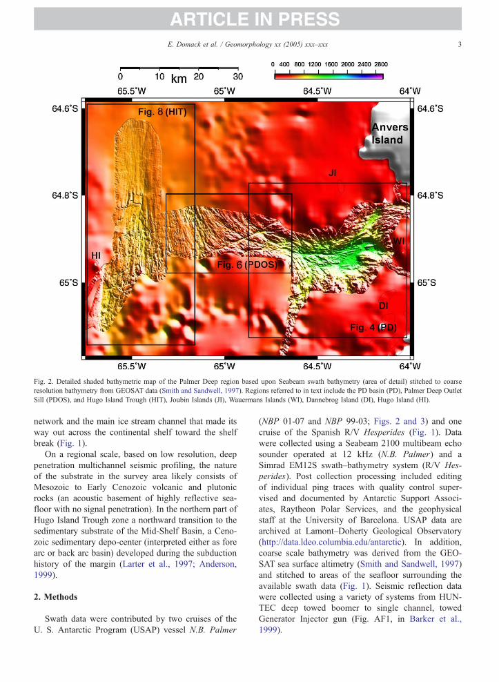
Deep trough funneled ice flow out across the shelf
where sub-glacial bed forms indicative of fast flow
have been imaged (Fig. 2). A constricted sill lies in
the transition between the clear ice stream portion of the
mid to outer shelf and the Palmer Deep. Across this sill
is a distinctive channelized morphology that reflects a
Fig. 1. Swath bathymetry and GEOSAT seafloor bathymetry (depth in m) off
Fig. 2 of Palmer Deep outlet system is indicated along with Anvers Island (A
Lobes are inter-trough banks and drifts are sediment mounds (after Barker a
by arrows with increasing width proportional to hierarchy of tributary syste
combination of glacial melt water scour and underlying
structural weakness within the bedrock (faulting and/or
jointing).
We divide the sub-glacial landscape into three major
zones based upon the meso- to mega-scale topography
but emphasize that all three systems were part of one
single glacial outlet during the most recent period of
expanded glaciation. These zones include from inner
shelf to outer shelf:
1. the Palmer Deep basin (PD, Fig. 2)
2. the Palmer Deep Outlet Sill (PDOS, Fig. 2)
3. the Hugo Island Trough (HIT, Fig. 2).
Not discussed in this paper are the inner most feeder
fjords that comprise the coastal portions of the drainage
shore Graham Land, western Antarctic Peninsula. Location of detailed
I), Biscoe Trough (BT), Bruce Plateau (BP) and Bismark Strait (BS).
nd Camerlenghi, 2002). Reconstructed glacial flow lines are indicated
ms. Insert shows location of study area in relation to Antarctica.
ARTICLE IN PRESS
Fig. 2. Detailed shaded bathymetric map of the Palmer Deep region based upon Seabeam swath bathymetry (area of detail) stitched to coarse
resolution bathymetry from GEOSAT data (Smith and Sandwell, 1997). Regions referred to in text include the PD basin (PD), Palmer Deep Outlet
Sill (PDOS), and Hugo Island Trough (HIT), Joubin Islands (JI), Wauermans Islands (WI), Dannebrog Island (DI), Hugo Island (HI).
E. Domack et al. / Geomorphology xx (2005) xxx–xxx 3
network and the main ice stream channel that made its
way out across the continental shelf toward the shelf
break (Fig. 1).
On a regional scale, based on low resolution, deep
penetration multichannel seismic profiling, the nature
of the substrate in the survey area likely consists of
Mesozoic to Early Cenozoic volcanic and plutonic
rocks (an acoustic basement of highly reflective sea-
floor with no signal penetration). In the northern part of
Hugo Island Trough zone a northward transition to the
sedimentary substrate of the Mid-Shelf Basin, a Ceno-
zoic sedimentary depo-center (interpreted either as fore
arc or back arc basin) developed during the subduction
history of the margin (Larter et al., 1997; Anderson,
1999).
2. Methods
Swath data were contributed by two cruises of the
U. S. Antarctic Program (USAP) vessel N.B. Palmer
(NBP 01-07 and NBP 99-03; Figs. 2 and 3) and one
cruise of the Spanish R/V Hesperides (Fig. 1). Data
were collected using a Seabeam 2100 multibeam echo
sounder operated at 12 kHz (N.B. Palmer) and a
Simrad EM12S swath–bathymetry system (R/V Hes-
perides). Post collection processing included editing
of individual ping traces with quality control super-
vised and documented by Antarctic Support Associ-
ates, Raytheon Polar Services, and the geophysical
staff at the University of Barcelona. USAP data are
archived at Lamont–Doherty Geological Observatory
(http://data.ldeo.columbia.edu/antarctic). In addition,
coarse scale bathymetry was derived from the GEO-
SAT sea surface altimetry (Smith and Sandwell, 1997)
and stitched to areas of the seafloor surrounding the
available swath data (Fig. 1). Seismic reflection data
were collected using a variety of systems from HUN-
TEC deep towed boomer to single channel, towed
Generator Injector gun (Fig. AF1, in Barker et al.,
1999).

AR
TIC
LE
IN P
RE
SS
Fig. 3. Detail bathymetric contour (swath) map of the Palmer Deep region with a contour interval of 20 m. Location of ODP (Leg 178) Sites 1098 and 1099 indicated along with Jumbo Piston Core
10 (JPC-10, cruise NBP 99-03) and kasten cores 15–17 (cruise NBP 01-07).
E.Domack
etal./Geomorphologyxx
(2005)xxx–
xxx4

ARTICLE IN PRESSE. Domack et al. / Geomorphology xx (2005) xxx–xxx 5
Two Ocean Drilling Program (ODP) sites were
occupied within the Palmer Deep during Leg 178,
sites 1098 and 1099 (Fig. 3; Barker and Camerlen-
ghi, 2002; Barker et al., 1999). A third, jumbo piston
core was collected during cruise NBP 99-03
(Domack et al., 2003). In addition, gravity (kasten)
cores were collected at all sites in order to provide
calibration and correlation to the sediment water
interface for subsequent radiocarbon analyses of
down-core material.
Radiocarbon analyses (via AMS) were conducted on
foraminifera, mollusc, and total organic matter fractions
as discussed previously (see, Domack et al., 2001,
2003). We include 25 previously unpublished dates in
this paper (Table 1) from Site 1099 and associated
gravity core KC-26.
Table 1
List of radiocarbon ages reported and incorporated in Fig. 10
Lab #
AA-
Core/
siteambsfb Total organic Uncorrected Calibrated
Carbon
%
d13C 14C agec Age yr BPd
29174 KC-26 0.005 1.01 �24.57 1610F55 modern
29175 KC-26 0.305 0.82 �24.83 2380F45 700F45
29176 KC-26 0.605 1.02 �24.14 2400F45 720F45
29177 KC-26 1.505 0.90 �24.88 3180F45 1520F45
29148 1099A 8.580 1.14 �24.58 4590F55 3250F55
29149 1099A 10.700 1.25 �23.67 4740F55 3400F55
29150 1099A 13.860 1.30 �23.40 5420F55 4290F55
29151 1099A 14.760 1.43 �23.57 5900F90 4870F90
29152 1099A 14.880 1.61 �23.06 6500F60 5640F60
29153 1099A 20.130 1.49 �23.11 6960F60 6170F60
29154 1099A 21.360 1.35 �22.64 7720F80 7000F80
29155 1099A 23.240 1.15 �23.43 8250F75 7540F75
29156 1099A 24.300 1.16 �23.49 8750F65 7970F65
29157 1099A 32.550 0.73 �24.24 9350F65 8590F65
29158 1099A 39.240 0.47 �25.02 12,680F80 12,990F80
29159 1099A 41.940 1.00 �24.84 9290F70 8530F70
29160 1099B 85.520 0.69 �23.17 11,300F90 11,090F90
29161 1099B 87.020 1.02 �22.85 11,760F70 11,650F70
29162 1099B 88.960 1.00 �23.38 9840F70 9030F70
29163 1099B 91.960 0.64 �24.14 10,945F70 10,330F70
29164 1099B 95.720 0.69 �24.77 10,890F70 10,317F70
29165 1099B 98.620 1.03 �23.22 10,990F70 10,570F70
29166 1099B 103.43 0.86 �23.04 11,830F75 11,880F75
29167 1099B 107.12 1.05 �22.73 12,120F80 12,580F80
AA=University of Arizona NSF-TAMS facility.a Core KC-26=kasten core 26 collected during cruise LMG 98-02.
Sites are composite Holes 1099A and 1099B collected during ODP
Leg 178.b mbsf=depth in core below sea floor not adjusted for stratigraphic
relationship and are given as mid-depths in 1 cm sample intervals.c Uncorrected ages are rounded to the nearest 10 years and are
adjusted for d13 C.d Calibrated ages are derived via a surface correction for particulate
reworking of 360 yr, a reservoir correction of 1250 yr (Bjorck et al.,
1991), and the routine outlined by Stuiver et al. (1998).
3. Observations of seafloor bathymetry
3.1. Palmer Deep
Within the Palmer Deep (PD; Fig. 2) we recognize
depositional and erosional features that are related to
the glacial and post-glacial history of the basin. The
bedrock surrounding the PD is crystalline metamorphic
and igneous rock related to Cenozoic arc volcanism.
These rocks were uplifted and dissected by extensive
glaciation that commenced in the Miocene (Barker and
Camerlenghi, 2002). The large-scale morphology of the
Palmer Deep basin is dominated by streamlined bed-
rock sculpted by glacial abrasion and plucking. Zones
of structural weakness within the crystalline basement
(joints and faults) are accentuated by the glacial ero-
sion, with most of these features oriented obliquely at
658 and 1208 (Rebesco et al., 1998; Sniffen, 2001).
Glacial flow patterns can readily be inferred to have
paralleled the east–west elongation of the Palmer Deep
basin with inflow from the surrounding elevated terrain
of Anvers Island, along Bismark Strait, and Graham
Land (Fig. 2).
Superimposed upon this overall streamlined relief,
however, are mega- to mesoscale features that are
revealed by detailed contouring of swath bathymetry
(Fig. 3). Based upon the relief depicted in Fig. 3 we
recognize distinctive submarine features including:
slope terraces, basin floor, channels, and prograded
slopes (Fig. 4).
The eastern end of the PD is characterized by a
steep, smooth slope (228) with a relief of 1200 m.
Seismic reflection profiles across this slope indicate
an internal set of prograded reflectors originating as
debris flows (Fig. 5; Rebesco et al., 1998). This depo-
sitional slope has undergone little apparent degradation
or glacial erosion. Its steep relief indicates significant
slope stability as would be likely if it were cored by
cohesive, poorly sorted deposits such as diamicton.
Unlike the eastern end of the PD, the northern and
southern slopes are punctuated by distinctive terraces
or perched basins that lie primarily between 500 and
900 m in depth. These terraces range in size from
several hundred m2 to 4 km2 with relief of less than
20 m. At least 25 terraces are recognized along the
northern and southern PD slopes (Fig. 4).
The western end of the PD has depositional and
erosional features and is characterized by a roughly
triangular area of flat relief (16 km2) that breaks eastward
into a smooth slope of 08 to 3.48, interpreted as a relict
delta. In support of this interpretation seismic profiles,
such as BAS line 845-03, S.P. 100-150 (Rob Larter,

ARTICLE IN PRESS
Fig. 4. Outline map of major seafloor features of the Palmer Deep basin including the relict delta (inferred topsets and foresets), incised sediment
gravity flow channel system, basin floor, debris flow slope, and terraces. See Fig. 3 for bathymetric details of outlined features.
E. Domack et al. / Geomorphology xx (2005) xxx–xxx6
unpublished), OGS profile IT95-H220 -H221 (Rebesco
et al., 1998), and USAP deep-tow Huntech profile LMG
98-2 (Domack, unpublished), indicate sub-bottom
reflectivity in this area (generated by soft sediments of
a submarine delta) as opposed to the high amplitude and
seafloor reflection, with no energy penetration, typical of
the northern and southern sides of the PD basin cast in
hard rock or covered by diamict. The western slope of the
PD is, therefore, much gentler than the steeper eastern
slope (Fig. 3). The western slope of the basin is also
dissected by a series of tributary channels (Fig. 4). These
merge eastward and deepen into a single incised channel,
up to 200 mwide and 50-100 m deep that extends 24 km,
in a roughly west to east direction. This channel termi-
nates in the flat basin floor of the PD, at a depth of 1400
m, but not before it takes a sharp southerly turn. The
longitudinal profile of the PD channel is continuous and
unbroken by reversals in slope, consistent with an origin
related to sediment gravity flows. Levees (20–40m high)
parallel the channel in portions of the PD basin deeper
than 1300 m (Fig. 3).
The basin floor of the PD generally lies below 1200
m depth; here only the slightest indication occurs of
glacial sculpting, characteristic of the shallow basement
rocks that surround the PD. At 1400 m depth the basin
floor is flat and the seismic profiles show ponded
sediments in excess of 200 m thick (Rebesco et al.,
1998; Kirby et al., 1998). Ocean Drilling Program
(ODP) Site 1099 was located in these ponded sediments
(Barker et al., 1999) and recovered 108 m of unconsol-
idated sediment before drilling was terminated because
of time constraints.
3.2. Palmer Deep outlet sill
Toward the west the PD basin transitions into a
shallow silled region of 420 km2 that is characterized
by a distinctive channelized terrain (Fig. 6). We refer to
this region as the PD Outlet Sill (PDOS) as the glacially
streamlined topography clearly indicates ice flow out of
the PD basin, onto the continental shelf, via this con-
stricted topography (Fig. 2).
The channels of the PDOS are broad (200–500 m
wide), deep (100–300 m), and intersect at distinct 758to 508 angles (Figs. 6 and 7). This later characteristic
reflects an underlying structural control, with faulting
or joint sets striking 658 to 1408 azimuth (Hawkes,
1981). Yet the NW to SE oriented channels conform
to the overall glacial streamlining of the seafloor by
taking on a curvilinear pattern toward the open shelf
(Fig. 2). Intersection points are typically over-deep-
ened, and individual channels demonstrate ubiquitous
reversals in longitudinal profile. Channel sides vary in
relief with some very steep slopes (458 or more) and
some more gentle. Where the channels are over deep-
ened and broad, the cross-section is typically U-shaped,
whereas more narrow interconnecting channels are typ-
ically V-shaped (Fig. 6). The extent to which this
reflects deposition or strictly erosion is irresolvable
with current imaging techniques. All of the observed
characteristics of the PDOS channels, however, are
similar to banastomosing channelsQ previously de-
scribed from the Pine Island Bay trough, Antarctic
Peninsula (Lowe and Anderson, 2002) and are of the
same scale as The Labyrinth channels found at the head

ARTICLE IN PRESS
Fig. 6. Gray scale swath bathymetry of the Palmer Deep Outlet Sill (PDOS), see Fig. 2 for regional location. Contour interval is 5 m.
Fig. 5. Seismic lines of across portions (color coded) of the Palmer Deep showing a smooth, steep depositional slope (yellow), a starved basin in the
northeast (blue), and a rocky basement to the southwest (red) surrounding draping sediments (green). Vertical scale is two-way travel time in
seconds.
E. Domack et al. / Geomorphology xx (2005) xxx–xxx 7

ARTICLE IN PRESS
Fig. 7. Outline map of major seafloor features of the PDOS and PD basin including gravity flow channels, relict delta, broad melt water channels,
and dispersed melt water channels. Unidirectional arrows indicate uniform profiles that deepen into PD basin while bidirectional arrows indicate
reversals in slope. Compare to Fig. 6 for bathymetric detail.
E. Domack et al. / Geomorphology xx (2005) xxx–xxx8
of Taylor Valley in the Dry Valleys of Victoria Land
(Benn and Evans, 1998) and the Gwaun–Jordonston
drainage networks of Wales (Sugden and John, 1976).
The inter-channel areas of the PDOS demonstrate a
glacially streamlined relief similar to the crystalline
basement that surrounds the PD basin proper (Fig. 3).
More distinctive drumlin-like bed forms (Fig. 6) with
steep stoss noses and elongate lee tails appear rather
than the more uniform erosional sculpting (areal scour-
ing) typical of the crystalline basement rocks surround-
ing the PD. These former features are similar to brochesmoutonneesQ described from the adjacent Biscoe
Trough (see Fig. 2a. in Canals et al., 2003, p. 102).
The quarried lee side terminations, typical of classic
roches moutonnees, however, are not resolved by avail-
able imagery techniques.
Toward the west the broad series of channels end by
opening into a series of dispersed and shallow incisions
that trend west to northwest (Fig. 7). These distributary
features occur where the relief decreases and progres-
sively deepens to between 500 and 800 m (Fig. 6). In a
gradual fashion the integrity of the channels is lost
toward the open continental shelf but the overall
streamlining of the seafloor is still preserved (Fig. 2)
by increasingly elongate bed forms.
3.3. Hugo Island Trough
The PDOS merges with a second ice drainage
system just east of Hugo Island (Figs. 1 and 2).
Here the flow patterns are clearly delineated by a
streamlined topography referred to as the Hugo Island
Trough (HIT; Fig. 8). The HIT maintains its integrity
out across the continental shelf until it merges with yet
another drainage outlet just northwest of Anvers Is-
land (Fig. 1). This combined system exits the conti-
nental shelf 150 km northwest of the PD basin. Within
the HIT the seafloor morphology changes into a
lineated one, dominated by mega-scale glacial linea-
tions (Figs. 8 and 9). Such transition reflects the
change from crystalline bedrock to the Mid-Shelf
Basin sedimentary substratum. Similar morphological
changes induced by changing basement have been
observed elsewhere along the Antarctic margin
(Anderson et al., 2001; Camerlenghi et al., 2001;
O’Cofaigh et al., 2002).
The mega-scale glacial lineations are more evident
just northward (in a seaward direction) of a prominent
set of scarps that mark either a (depositional) grounding
line wedge or (bedrock) submarine cuesta (Fig. 9). The
scarps also delineate the seaward limit of a rough
seafloor morphology, characterized by relatively small
but high relief incisions (channels) that converge to-
ward a break in the scarp (Figs. 8 and 9). The mor-
phology landward of the break is negative, while
seaward of the scarp the breach point is of positive
relief. This association is similar to that of forms mark-
ing the breach in submarine moraines from the Mertz
Trough, off the East Antarctic margin (McMullen et al.,
2002).
The mega-scale glacial lineations within the HIT
run due north for at least 30 km (Fig. 9) and likely
extend to the shelf break another 120 km, where sub-
glacial grounding line features have been imaged

ARTICLE IN PRESS
Fig. 8. Grey scale swath bathymetry of the Hugo Island Trough (HIT)
showing locations of gravity cores collected during cruise NBP-01-
07. See Fig. 2 for regional location. Contour interval is 10 m.
E. Domack et al. / Geomorphology xx (2005) xxx–xxx 9
(Larter and Vanneste, 1995). Unlike the shallow outer
shelf of most of the Antarctic margin (Shipp et al.,
1999) little evidence exists for iceberg scour across
these features in the HIT. The scale of the lineations
(~25 m high, 2 km in wavelength) is identical to
features recognized from the Ross Sea (Shipp et al.,
1999, 2002) and Mertz Trough (McMullen et al.,
2002). No evidence of channels exists within the
mega-scale glacial lineations, so characteristic of the
PD basin and PDOS system.
4. Sediment core stratigraphy
The chronology we present (Table 1 and Fig. 10) is
based upon accelerator 14C dating of marine organic
matter (25 samples) and correlation of physical proper-
ties to a calibrated radiocarbon time scale from the
immediate vicinity of site 1099. Difficulties occur in
the application of radiocarbon dating to marine sedi-
ments in Antarctica because of the large reservoir effect
(Harden et al., 1992; Bjorck et al., 1991; Gordon and
Harkness, 1992) and corrections for reworked organic
particulates (Domack et al., 1999; Andrews et al.,
1999). Yet the Palmer Deep record is exceptional in
that surface organic matter provides radiocarbon ages
equal to established reservoir ages (Site 1098) and the
correction for reworking of detrital organic matter is
minimal (360 years) at site 1099 (Fig. 10, Table 1).
Replicate analyses also provide excellent agreement
that is less than the laboratory (analytical) error of
F50 years. Hence the Palmer Deep sedimentary record
contains a very reliable radiocarbon chronology and
serves as a circum Antarctic paleoenvironmental refer-
ence section (Domack et al., 2001).
At site 1099, 108 m of interbedded laminated diatom
ooze/sandy mud and homogenous diatom mud/thin
muddy sand (Fig. 10) record alternating periods of
hemipelagic and ice rafted deposition interrupted by
periodic turbidity current deposition, including one
megaturbidite. Rates of hemipelagic sedimentation are
2 to 7 mm/yr. The large-scale turbidite sequences are
consistent with site 1099 being located on the flat basin
floor of the Palmer Deep (Kirby et al., 1998). We divide
the stratigraphy into four units consistent with previous
division of the nearby site 1098 lithofacies. Unit I is late
Holocene in age (0 to 3250 cal. yr BP) and consists of
interbedded diatom mud turbidites and hemipelagic
diatom mud that accumulated at rates of less than 1
mm/yr (exclusive of turbidites; Kirby et al., 1998). Unit
I is characterized by relatively high and variable mag-
netic susceptibility, reflecting a dominance of small
multidomain magnetite and interbedding of diatom-
rich (paramagnetic) and diatom poor laminations. Unit
II consists of laminated diatom mud and ooze with
fewer and thinner diatom mud turbidites that accumu-
lated at rates of up to 3.2 mm/yr. It is characterized by
lower magnetic susceptibility and ranges in age from
3.2 ka to 8.0 yr BP. Units I and II represent the late
Holocene Neoglaciation and the middle Holocene cli-
matic optimum, respectively. These units can be unam-
biguously correlated by age, sedimentary structures,
and MS with site 1098 (Figs. 3 and 10), thus, attesting
to the robust application of corrected radiocarbon ages

ARTICLE IN PRESS
Fig. 9. Outline map of some of the seafloor features characteristic of the HIT region including mega-scale glacial lineations, drumlin forms, spindle-
forms, and erosional breaches of submarine ridges (a moraine or cuesta). On this later feature shading of negative (erosional) relief lies landward of
positive (depositional) relief, thus suggesting the transfer of sediment via melt water through the breach point in a seaward direction following the
ideas of McMullen et al. (2002). Compare to Fig. 7 for bathymetric detail.
E. Domack et al. / Geomorphology xx (2005) xxx–xxx10
in both sequences. Unit III is characterized by unusu-
ally thick turbidite intervals, one in excess of 30 m that
are interbedded with laminated diatom ooze and mud
and contain concentrations of ice rafted debris (IRD). In
places, such IRD comprises a thin bed where concen-
trations of ice-rafted material were sufficient to produce
a poorly sorted diamicton (Fig. 10). Unlike all other
turbidites in core 1099AB, the megaturbidite (MT-2 at
35 to 75 m below the sediment surface; Fig. 10) is
marked by coarse, gravelly sand at its base, clearly
attesting to the energy of transport within the Palmer
Deep basin at that time. Unit III dates to between 8 ka
to 11.5 ka yr BP.
The bottom sediments (Unit IV) in cores from Site
1099B are rhythmically laminated diatom ooze and
sandy mud. These laminations are varves that record
unique conditions during the recession of glacial ice
from within the PD basin (Leventer et al., 2002). These
varved sediments likely extend beyond the 108 m reach
of Site 1098 and are underlain by an additional 100 m
of unconsolidated sediment, most likely with additional
Fig. 10. Core lithology and radiocarbon chronology of cores from the PD bas
are previously reported and discussed by Kirby et al. (1998) and Domack et
LMG98-2 core KC-26 are based upon physical correlation of key beds (turb
al., 1998). Correlations between 1099 and 1098 are based upon uncorrected
font) as discussed in the text and in Table 1. Calibrated ages for 1098 are l
intervals and these along with Units I–IV are discussed in text.
turbidite intervals (Barker et al., 1999). The varved
sediments at Site 1099 date to between 12,600 and
11,800 BP. Hence, the total thickness of basin fill
(~200 m) and its character within the PD have yet to
be recovered by drilling or coring.
The entire sediment package to basement was recov-
ered at site 1098 located in a perched basin in water
depths of 1000 m, some 12 km to the northeast of Site
1099 (Fig. 3). The recovered stratigraphy is identical to
that from 1099 except for the exclusion of thick turbi-
dites (Domack et al., 2001). At Site 1098, 45 m of post-
glacial sediment was found to overly glacial diamicton
(till) consistent with the seismic stratigraphy of the site
(Rebesco et al., 1998; Barker et al., 2001). Details of
the sediments at Site 1098 are summarized by Domack
(2002).
5. Interpretation
Little doubt exists that the continental shelf sur-
rounding the Palmer Deep has undergone many epi-
in along with magnetic susceptibility. All ages are listed in Table 1, or
al. (2001). Stratigraphic correlations between ODP Site 1099A,B and
idites) T1 through T6, recognized in other cores from the PD (Kirby et
radiocarbon ages (small font) that are corrected and calibrated (large
isted as reported in Domack et al. (2001). MT refers to megaturbidite

ARTICLE IN PRESSE. Domack et al. / Geomorphology xx (2005) xxx–xxx 11

ARTICLE IN PRESS
Fig. 11. (a) View from over the Palmer Deep basin to the northeast of
the elevated terrain of Anvers Island, with Mt Moberly and Mt.
William to right of center, at elevations of 1524 m and 1506 m,
respectively. (b) View of one of the islands off the Graham Land
Coast illustrating ice carapace and glacial/firn cover to sea level. (c)
View of Cape Renard (elevation of 743 m) along Graham/Danco
Coast just southeast of Palmer Deep Basin illustrating erosional
pinnacles indicative of radial flow patterns.
E. Domack et al. / Geomorphology xx (2005) xxx–xxx12
sodes of late Neogene to Quaternary glaciation (Barker
et al., 1999; Bart and Anderson, 1995; Larter et al.,
1997). The present seafloor relief must, therefore, re-
flect repeated modification, if not amplification, by
these multiple glaciations. Yet seismic reflection data
(Rebesco et al., 1998; Barker et al., 1999), the estab-
lished sediment core stratigraphy (Kirby et al., 1998;
Domack et al., 2001, 2003), and terrestrial records
(Hjort et al., 2003) clearly constrain the most recent
episode of glacial erosion and glacial marine deposition
during and following the Last Glacial Maximum. With-
in this time frame, Marine Isotope Stage 2 (LGM, MIS-
2) we, therefore, propose several stages in the evolution
of the basin as discussed below.
5.1. Ice dome growth and expansion
A phase of expanding glaciation coincided with
period(s) of lowered eustatic sea level, ice dome growth
(flow divergence), and flow convergence into the PD.
Today, two elevated ice domes are greater than 2000 m
above sea level, one on Anvers Island (The Maar Ice
Piedmont) and the other the glacial carapace of the
Bruce Plateau, Graham Land (Figs. 1 and 11). Both
of these ice domes are immediately adjacent to the
northern and southern margins of the PD basin via
shallow coastal waters (less than 200 m; Fig. 2).
These shallows extend around the PD basin to within
2 km, as marked by the emergence of the Joubin,
Wauwermans, Dannebrog, Myriad, and Argentine
Islands, collectively known as the Wilhelm Archipelago
(Figs. 2 and 3). Today, all of these islands are mantled
by thin ice/firn caps whose extents are only limited by
the small size of the emergent rock and wave action
along the shore (Fig. 11b). During periods of lowered
sea level, such as the transition from MIS-3 to MIS-2 or
earlier, the extent of emergent land would have in-
creased, and seaward expansion of the Anvers Island
and Bruce Plateau ice domes could have quickly
encroached upon the northern and southern rim of the
PD basin. Likewise, the Hugo Island, Betbeder and Pitt
Island system to the west to southwest (respectively)
would have also provided emergent platforms for the
formation of localized ice caps. This, coupled with
colder temperatures, would have provided the impetus
(pinning points) for the formation of localized ice shelf
conditions within, or across, the PD basin. At this time
a glacial flow directed from east to west through the PD
Basin was fed by way of the Bismark Strait and its
tributaries, the Neumayer Channel and Flandres Bay.
The outlet glaciers that drained the southeastern slopes
of Anvers Island and the northern edge of the Bruce
Plateau, progressively expanded the grounding lines
through the depth (greater than 800 m) and length (30
to 50 km) of the Neumayer Channel and Etienne Fjord/
Flandres Bay, respectively.
5.2. Sub-glacial lake in Palmer Deep basin
The presence of a sub-glacial lake within the Palmer
Deep was first proposed by Rebesco et al. (1998).

ARTICLE IN PRESSE. Domack et al. / Geomorphology xx (2005) xxx–xxx 13
Critical in the argument for its formation is the require-
ment of near complete encirclement by grounded gla-
cial ice around the basin. We believe that this was quite
plausible given the above discussion. The evidence for
the lake basin itself is partially preserved in the form of
depositional slopes around the PD basin (Fig. 4). The
western end of the basin, we believe, is the erosional
remnant of a sub-glacial lake delta that at one time was
fed by sub-glacial melt water emanating from the chan-
nels of the PDOS (Figs. 2–4). The use of the term sub-
glacial lake delta follows the usage of the term by
Gjessing (1960) and subsequently discussed and illus-
trated by Sugden and John (1976). In this use of the
term, and of the feature recognized in the PD, the sub-
glacial lake delta sediments do not record a local or
global base level, as terrestrial deltas do. Instead, they
record the upward transition of sediments into a stand-
ing body of water in accordance to this change in
hydraulic conditions. Flow into a confined water body
beneath glacial ice implies some loss of volume of the
reservoir (under melting of ice) which is compensated
by fluid flow into the system. Hence, the velocity and
consequent turbulence of the melt water inflow into the
lake would be limited, unless a free water surface
connection to the atmosphere existed.
A conservative estimate of the volume of the PD
sub-glacial lake is about 20 km3 and its greatest depth
would have been on the order of 800 m, if the terraces
and delta mark the ice-water interface and the deep
basin fill (200 m of sediment) are removed. Its surface
dimension, although somewhat irregular, would have
been approximately 8 km in diameter. This is small
compared to known Antarctic sub-glacial lakes whose
dimensions are estimated by widely spaced radio echo
sounding (Siegert et al., 1996). Modern Antarctic sub-
glacial lakes all lay beneath 2.3 km or more of ice, are
found along major ice divides (low surface gradient and
ice velocity), and are 300 km or more from the coast
(Siegert et al., 1996). The relief of the PD sub-glacial
lake is, however, much better known than any existing
sub-glacial lake basin, including sub-glacial Lake Vos-
tok (Kapista et al., 1996). Hydraulic pressure feeding
into the delta system (via the PDSO channels) was in
excess of the cryostatic force of the ice shelf across the
PD basin. This could result if localized domes south-
west of the PD basin at the time where significantly
thick and/or significant melt water production from the
surface plumbed (i.e., Zwally et al., 2002) the PDOS
channel system. At this stage in the development of the
system we require a reversal in ice surface slope from
the normal down gradient decrease in elevation. This is
consistent with both the observed ice surface character
over existing sub-glacial lakes (such as at Vostok,
Kapista et al., 1996) and a newly proposed model for
sub-glacial lake formation during glacial expansion
across continental shelves (Alley et al., 2005—this
volume). Critical to the later model is the requirement
for at least partial marine salinity of entrapped water
during lake formation, which helps to prevent large
scale freezing of the reservoir beneath glacial ice.
The prograding slopes of the delta, that should con-
tain foresets, are only partially preserved along the
southern and northern edge of the basin as low relief,
relatively low angle depositional slopes. These were
dissected by subsequent gravity flows in the middle
(Figs. 3 and 4). Therefore, the former delta predates
the PD turbidite channel because it is cross-cut (eroded)
by the channel tributaries. The gentle foreset slope of
the delta likely represents fine-grained sediment of silt
or mud, rather than coarse and cohesive diamicton that
would be expected to have a higher angle of repose
such as found along the eastern end of the PD basin.
In the late stage of the Palmer Deep sub-glacial lake,
ice flowing out of the Bismarck Strait is likely to have
created a grounding line as it encroached from the east.
The flow of the outlet system at this end of the basin
was responsible for progradation of a debris slope
(resulting from the accumulation of debris flows) and
the development of the steep and even relief along the
eastern end of the basin (Figs. 3 and 4). This steep
prograded slope clearly predates the deep basin fill
strata which pond and on-lap near-surface reflectors
that comprise the slope (Rebesco et al., 1998; Fig. 5).
The terraces identified along the northern and south-
ern slopes of the PD basin (Fig. 4) are interpreted to
represent the ponding of fine sediment within depres-
sions or breaks in the slope. The fine detritus originated
as dilute melt plumes which emanated from along the
grounding line/ shoreline of the sub-glacial lake. Such
processes are observed today from within fjord heads
where dilute glacial melt waters transport silt and clay
aggregates (flocs) out from underneath sub-glacial cav-
ities (Domack and Williams, 1990; Domack et al.,
1994). Coring of one of the terraces in the PD (JPC
10; Fig. 3) recovered 12 m of post-glacial marine
diatom ooze overlying clay and laminated diatom bear-
ing mud, dated to 9000 yr BP (Domack et al., 2003).
No diamict was recovered at this site.
5.3. Shelf edge grounding and evacuation of Palmer
Deep sub-glacial lake
Eventually, with continued low sea level conditions
and build up of ice along the elevated domes, glacial

ARTICLE IN PRESSE. Domack et al. / Geomorphology xx (2005) xxx–xxx14
expansion forced ice to ground within the PD basin and
merge with tributaries out across the PDOS, HIT, and
continental shelf. The mega-scale glacial lineations and
drumlinized seafloor of the outer PDOS and HIT are
evidence of this. The glacial sculpting along the flanks
and bottom of the PD basin also took place at this time.
Yet these later features are partially buried by post-
glacial marine sediment in the PD basin. Partial erosion
of the delta also took place at this time, perhaps focused
by faster flow in the central portion of the PD basin. As
ice thickened and surface elevations became steeper,
water within the PD sub-glacial lake must have been
forced to drain to the west down the hydrostatic gradi-
ent. This gradient would have been partially reversed
from earlier on and would have forced water out
through the PDOS channels (Fig. 7), thus, further erod-
ing and reshaping them. This would have occurred at a
time of maximum ice extent and thickness and is
consistent with new models for sub-glacial lake forma-
tion along glaciated continental shelves during maxi-
mum glaciations (Alley et al., 2005—this volume).
Maximum ice thickness is envisaged to have pro-
duced distinct domes larger than those on Anvers Island
(Palmer Archipelago) and along the Graham Land Coast
(Fig. 12). The Graham Land dome is proposed to have
occupied the region just east of the PD basin where
erosional landforms (horns) indicative of radial flow
are prominent features of the coastal landscape (Fig.
11c; see also Fig. 9.1 in Skinner et al., 1999, p. 190).
The flushing of basal water out through the PDOS
into the HIT could have helped lubricate the bed and,
hence, sculpt glacial till. The bed forms leading out of the
PDOS channels indicate dispersal of melt water not
confinement (Fig. 4). Hence, one mechanism of enhanc-
ing glacial flow out through the PD ice stream system
could have been provided by closure of the PD basin sub-
glacial lake. We suggest that this enhanced the develop-
ment of mega-scale glacial lineations within the main
axis of flow by increasing the flow velocity across and
within the substrate. The volume of water within the PD
sub-glacial lake was unlikely sufficient to provide a
through flow to the shelf edge but enhanced ice flow in
the inner most part of the shelf could have provided one
way to lower the ice elevation across the inner shelf at the
same time as eustatic sea levels were beginning to rise.
5.4. Lowering of glacial surface and recession of ice
stream system
We hypothesize that with the addition of basal water
to the till system beneath the outer HIT, flow of the PD
outlet accelerated. This could have been aided by addi-
tion of surface melt water if climate conditions warmed
following the LGM (MIS-2) as surface melt water today
accelerates flow of the Greenland Ice Sheet and its
outlets (Zwally et al., 2002). With acceleration of drain-
age, via the PD ice stream, surface elevations of the
surrounding ice sheet would have decreased, leading
eventually to thinner ice within the ice stream and its
drainage. Such a lowering of ice surface elevations
following maximum conditions, when coupled with
rising eustatic sea levels, would have provided sufficient
instability to increase rates of calving. Hence, we envi-
sion a situation where calving bay reentrants (see Hille-
fors, 1979) were created along the entire front of the PD
ice stream during deglaciation. As the ice stream system
retreated across the PD basin, restricted conditions of
circulation and enhanced sediment focusing within the
PD basin commenced, consistent with the detailed stra-
tigraphy of ODP sites 1098 and 1099 (Leventer et al.,
2002). In cores from Site 1098, at the bottom of the
section above glacial till a unique varved sequence
exists of diatom ooze and sandy, silty, clay. This litho-
facies represents very high productivity and deposition
of ice-rafted material in annual cycles for a period of
approximately 200 years. The identical interval is found
in Site 1099, although the contact with glacial till was
not recovered (Unit IV, Fig. 10).
5.5. Dissection of relict delta and turbidite channels in
Palmer Deep basin
As the PD basin became a marine system, significant
erosion of the relict delta at the western end led to
incision of the major channels leading down into the
PD basin floor (Fig. 4). The products of this instability
and erosion were numerous as evidenced by the massive
turbidites ponded in the deep basin. At Site 1099 (Fig.
10) one of these turbidites is 30 m thick and comprises
what is termed a megaturbidite (Bouma, 1987; Rebesco
et al., 2000). These were deposited as recently as 9000 yr
BP, while most were deposited prior to this as shown by
another 100 m of section lying below the cored intervals
at Site 1099. The seismic reflection data from across the
PD basin clearly indicate that the basin infill post-dates
the debris slope of the eastern end of the basin (Rebesco
et al., 1998; Fig. 5). In addition, the subtle glacial sculpt-
ing of the PD basin itself, a product of maximum glacial
conditions, is partially masked by the turbidite infill at
the bottom of the basin. Following this initial period of
sediment gravity flows, hemi pelagic and pelagic depo-
sition dominated across the PD basin with slightly more
recent deglaciation within the perched basin at Site 1098
(Fig. 3).

ARTICLE IN PRESS
Fig. 12. (a) Regional outline map of PD ice stream (outlet) system and reconstructed grounding line position of Peninsula Ice Sheet during the LGM
or MIS-2 (modified after Anderson, 1999). Ice flow directions are parallel, thin solid lines, ice domes by dotted lines, and drainage divides by bold
dashed lines. Compare to Fig. 1 for relative scale. Note also the initiation of ice flow of the Gerlache Boyd Strait ice stream (Canals et al., 2000) at
the divide with the PD system. Rectangle shows location of detailed flow in PD based upon Fig. 2. The Biscoe Island system is outlined after
Amblas et al. (in press). (b) Cross-section along flow path of PD ice stream from the edge of the shelf (A) to the elevated spine of the Bruce Plateau
(AV). Also shown is the hypothetical reconstruction of the surface profile of the PD system (dotted line), modern sea level, and the approximate sea
level during maximum glaciation (dashed line). No account of glacial isostatic adjustment of the crust occurs in the reconstruction. Location of
profile A–AV is in Fig. 12a. Location of ODP Leg 178 drilling sites are also shown.
E. Domack et al. / Geomorphology xx (2005) xxx–xxx 15

ARTICLE IN PRESSE. Domack et al. / Geomorphology xx (2005) xxx–xxx16
5.6. Clearance of glacial ice from the Bismark and
Gerlache Strait and Neumayer Channel
The final episode in deglaciation was the clearance of
the straits between Anvers Island and the Danco Coast, a
section of the Graham Land Coast. This was accom-
plished by 8000 yr BP as post glacial marine sediments
within the fjords date to 7000 to 8000 yr BP (Ingolfsson
and Hjort, 2002; Shevenell et al., 1996; unpublished data
from Paradise Harbor). We suggest that this final phase
of retreat from the trough began with the calving bay
reentrants across the continental shelf. Accompanying
this was recession of ice from the shallow banks sur-
rounding Anvers Island and the Wilhelm Archipelago
coincident with final phases of eustatic sea level rise.
6. Conclusions
Detailed bathymetric characteristics and seafloor re-
lief, coupled with stratigraphic observations from ODP
Sites 1098 and 1099, support the occurrence of a sub-
glacial lake within the PD basin just prior to the LGM
(MIS-2) conditions. We propose the following se-
quence of events to explain the specific morphologic
features and stratigraphic units associated with the
Palmer Deep ice stream system.
1. A Phase of initial glaciation coincided with period(s)
of lowered eustatic sea level, ice dome growth (ex-
pansion and flow divergence), and flow convergence
into PD.
2. A phase of sub-glacial lake formation was induced
by ice shelf cover over the Palmer Deep and ground-
ing across the PDOS. This phase was associated
with initiation of back flow of ice and some sub
glacial melt water into the basin. Formation of PD
slope features occurred such as the delta on the
western slope, the steep debris flow slope, and ter-
races along the northern and southern margins. The
delta was fed by sub-glacial melt water that con-
verged toward the east, via the early stage melt water
channels of the PDOS system.
3. Glacial expansion and grounding of glacial ice with-
in the PD basin and to the shelf edge occurred during
the period of lowest sea level (MIS-2) about 22 to 18
ka BP. Glacial abrasion within the PD basin, PDOS,
and HIT initiated the formation of mega-scale glacial
lineations.
4. Melt water evacuated the PD sub-glacial lake via the
PDOS and HIT as it enlarged the sub-glacial melt
water channels in the PDOS system, breached scarps
within the HIT and dispersed melt water into the HIT
and till substrate. This was associated with enhanced
streaming of ice through the entire outlet system but
especially with the HIT.
5. This melt water evacuation enhanced the flow of
the ice stream, which subsequently lowered the ice
surface.
6. Calving bay reentrants caused recession of the ice
stream progressively back into the PD basin from the
outer to middle shelf, to the HIT and the PDOS
systems.
7. The delta in the western end of the PD basin was
dissected and a turbidite channel in the PD basin was
created by sediment gravity flows which also depos-
ited the ponded sequence recovered from ODP Site
1099 commencing about 13,000 yr BP.
8. A pelagic and hemipelagic sediment drape formed
across the terraces and Palmer Deep basins since
~11,000 yr BP (ODP Site 1098, 1099, and Jumbo
Piston Core site 10).
9. Glacial ice left the straits between Anvers Island and
the Graham Land Coast (Fig. 1) and retreated to
fjord headlands by around 7 to 8 ka y BP.
The characteristics of the PD sub-glacial lake may
have important analogies with existing sub-glacial lakes
beneath the Antarctic Ice Sheet (Ozwald and Robin,
1973; Kapista et al., 1996; Siegert et al., 1996), former
ice sheets (Shoemaker, 1991) and the drainage of for-
mer ice sheets and their sub glacial reservoirs of water
(Shoemaker, 1991; Alley et al., 2005—this volume).
The timing of events is also significant and our results
indicate deglaciation of the PD basin by 13 ka, some 1
ka after Meltwater Pulse 1A, suggested by some to have
been caused by Antarctic glacial recession (Clark et al.,
2002). Yet the PD results are in-phase with the timing
for glacial recession in the western Ross Sea (Domack
et al., 1999), the NW Weddell Sea (Brachfeld et al.,
2003), and the Prydz Bay continental shelf (Domack et
al., 1998; O’Brien et al., 1998). Additional work on the
chronology of deglacial events from the Antarctic mar-
gin, especially from the outer shelf (Pudsey et al., 1994;
Pope and Anderson, 1992) is clearly needed to resolve
this growing controversy.
Acknowledgements
The authors wish to thank participants and co-inves-
tigators on cruises of the USAP Nathaniel B. Palmer
(NBP99-03 and NBP01-07), L. M. Gould (LMG98-02),
JOIDES Resolution (ODP Leg 178), and the 2001
cruise of the R/V Hesperides. These efforts were sup-
ported by NSF Office of Polar Programs grants (OPP-

ARTICLE IN PRESSE. Domack et al. / Geomorphology xx (2005) xxx–xxx 17
9615053 and OPP-000306, to Hamilton College) the
Joint Oceanographic Institutions (JOI/USSSP funding
for ODP Leg 178), and the Spain-Italy-Belgium COHI-
MAR/SEDANO project (ref. REN2000-0896), Coop-
eracion Espana–USA en investigacion antartica en
Geociencias Marinas (GEMARANT) (Ref. 99120,
funded by the Spanish–USA Program for Scientific
and Technological Cooperation) and Generalitat de
Catalunya grant to CRG on Marine Geosciences of
the University of Barcelona (Ref. 2001SGR 00076).
Funding from Italy was through PNRA. Thanks are
also extended to the Antarctic Marine Geology Facility,
T. Janecek and his staff, at the Florida State University
for their assistance with sediment cores.
References
Alley, R.B., Dupont, T.K., Parizek, B.R., Anandakrishnan, S., Law-
son, D.E., Larson, G.J., Evenson, E.B., 2005—this volume. Out-
burst flooding and the initiation of ice-stream surges in response
to climate cooling: a hypothesis. Geomorphology. doi:10.1016/
j.geomorph.2004.01.011.
Amblas, D., Urgeles, R., Canals, M., Calafat, A., Rebesco, M.,
Cameslenghi, A., Estrada, F., DeBatist, M., Hugues-Clarke, J.E.,
in press. Relationship between continental rise development and
palaeo-ice sheet dynamics, Northern Antarctic Peninsula Pacific
margin. Quaternary Science Reviews.
Anderson, J.B., 1999. Antarctic Marine Geology. Cambridge Univer-
sity Press. 289 pp.
Anderson, J.B., Smith Wellner, J., Lowe, A.L., Mosola, A.B., Shipp,
S.S., 2001. Footprint of the expanded west Antarctic ice sheet: ice
stream history and behavior. GSA Today 11 (10), 4–9.
Andrews, J.T., Domack, E.W., Cunningham, W.L., Leventer, A.,
Licht, K.J., Jull, A.J.T., DeMaster, D.J., Jennings, A., 1999.
Problems and possible solutions concerning radiocarbon dating
of surface marine sediments, Antarctica. Quaternary Research 52,
206–216.
Barker, P.F., Camerlenghi, A., 2002. Glacial history of the Antarctic
Peninsula from Pacific margin sediments, In: Barker, P.F., Camer-
lenghi, A., Acton, G.D., and Ramsay, A.T.S. (Eds.), Proc. ODP,
Sci. Results, 178 [CD ROM], College Station TX (Ocean Drilling
Program), 1–40.
Barker, P.F., Camerlenghi, A., Acton, G.D. and others, 1999. Proc. Of
the O.D.P. Initial Reports 178 [CD-ROM]. Available from: Ocean
Drilling Program, Texas A and M Univ., College Station TX,
77845-9547, USA.
Bart, P.J., Anderson, J.B., 1995. Seismic record of glacial events
affecting the Pacific margin of the northwestern Antarctic Penin-
sula. In: Cooper, A.K., Barker, P.F., Brancolini, G. (Eds.), Geol-
ogy and Seismic Stratigraphy of the Antarctic Margin, Antarctic
Research Series vol. 68. American Geophysical Union, Washing-
ton D.C., pp. 75–95.
Benn, D.I., Evans, D.J.A., 1998. Glaciers and Glaciation. Arnold,
London. 734 pp.
Bentley, M.J., Anderson, J.B., 1998. Glacial and marine geological
evidence for the ice-sheet configuration in the Weddell Sea–
Antarctic Peninsula region during the last glacial maximum.
Antarctic Science 10, 309–325.
Bjorck, S., Hjort, C., Ingolfsson, O., Skog, G., 1991. Radiocarbon
dates from the Antarctic Peninsula region—problems and poten-
tial. In: Lowe, J.J. (Ed.), Radiocarbon Dating: Recent Applica-
tions and Future Potential, Quaternary Proceedings, vol. 1.
Quaternary Research Association, Cambridge, pp. 55–56.
Bouma, A.H., 1987. Megaturbidite: an acceptable term? Geo-Marine
Letters 7, 63–67.
Brachfeld, S., Domack, E., Kissel, C., Laj, C., Leventer, A., Ishman,
S., Gilbert, R., Camerlenghi, A., Eglinton, L.B., 2003. Holocene
history of the Larsen-A ice shelf constrained by geomagnetic
paleointensity dating. Geology 31, 749–752.
Camerlenghi, A., Domack, E., Rebesco, M., Gilbert, R., Ishman, S.,
Leventer, A., Brachfeld, S., Drake, A., 2001. Glacial morphology
and post-glacial contourites in northern Prince Gustav Channel
(NW Weddell Sea, Antarctica). Marine Geophysical Researches
22, 417–443.
Canals, M., Urgeles, R., Calafat, A.M., 2000. Deep sea-floor evi-
dence of past ice streams off the Antarctic Peninsula. Geology
28, 31–34.
Canals, M., Casamor, M.L., Urgeles, R., Calafat, A.M., Domack,
E.W., Baraza, J., Farran, M., DeBatist, M., 2002. Seafloor evi-
dence of a subglacial sedimentary system off the northern Ant-
arctic Peninsula. Geology 30, 603–606.
Canals, M., Calafat, A., Camerlenghi, A., DeBatist, M., Urgeles, R.,
Farran, M.L., Geletti, R., Versteeg, W., Amblas, D., Rebesco, M.,
Casamor, J.L., Sanchez, A., Willmott, V., Lastras, G., Imbo, Y.,
2003. Uncovering the footprint of former ice streams off Antarc-
tica. EOS 84 (97), 102–103.
Clark, P.U., Mitrovica, J.X., Milne, G.A., Tamisiea, M.E., 2002. Sea-
level fingerprinting as a direct test for the source of global
meltwater pulse 1A. Science 295, 2438–2441.
Domack, E.W., 2002. A synthesis for Site 1098: Palmer Deep. In:
Barker, P.F., Camerlenghi, A., Acton, G.D., Ramsay, A.T.S.Proc.
ODP, Sci. Results vol. 178. Ocean Drilling Program, College
Station, TX, pp. 1–14. Chapter 34.
Domack, E.W., Williams, C.R., 1990. Fine-structure and suspended
sediment transport in three Antarctic fjords. Antarctic Research
Series, American Geophysical Union 50, 71–89.
Domack, E.W., Foss, D.J.P., Syvitski, J.P.M., McClennen, C.E., 1994.
Transport of suspended particulate matter in an Antarctic fjord.
Marine Geology 121, 161–170.
Domack, E.W., O’Brien, P., Harris, P., Taylor, F., Quilty, P.G., DeSan-
tis, L., Raker, B., 1998. Late Quaternary sediment facies in Prydz
Bay, east Antarctica and their relationship to glacial advance onto
the continental shelf. Antarctic Science 10, 236–246.
Domack, E.W., Jacobson, E.A., Shipp, S.S., Anderson, J.B., 1999.
Late Pleistocene/Holocene retreat of the west Antarctic ice sheet
in the Ross Sea. Part 2. Sedimentologic and stratigraphic signa-
ture. Geological Society of America Bulletin 111, 1517–1536.
Domack, E.W., Leventer, A., Dunbar, R., Taylor, F., Brachfeld, S.,
Sjunneskog, C., ODP Leg 178 Scientific Party, 2001. Chronology
of the Palmer Deep site, Antarctic Peninsula: a Holocene
palaeoenvironmental reference for the circum-Antarctic. The Ho-
locene 11, 1–9.
Domack, E.W., Leventer, A., Root, S., Ring, J., Williams, E., Carlson,
D., Hirshorn, E., Wright, W., Gilbert, R., Burr, G., 2003. Marine
sedimentary record of natural environmental variability and recent
warming in the Antarctic Peninsula. In: Domack, E.W., Leventer,
A., Burnett, A., Bindschadler, R., Convey, P., Kirby, M. (Eds.),
Antarctic Peninsula Climate Variability: a Historical and Paleoen-
vironmental Perspective, Antarctic Research Series, vol. 79.
American Geophysical Union, pp. 205–224.

ARTICLE IN PRESSE. Domack et al. / Geomorphology xx (2005) xxx–xxx18
Gilbert, R., Domack, E.W., Camerlenghi, A., 2003. Deglacial history
of the Greenpeace Trough: ice sheet to ice shelf transition in the
northwestern Weddell Sea. In: Domack, E.W., Leventer, A., Bur-
nett, A., Bindschadler, R., Convey, P., Kirby, M. (Eds.), Antarctic
Peninsula Climate Variability: a Historical and Paleoenvironmen-
tal Perspective, Antarctic Research Series, vol. 79. American
Geophysical Union, pp. 195–204.
Gjessing, J., 1960. Isavsmeltingstidens drenering, dens forløp og
formdannende virkning i Nodre Atnedalen med sammenlignende
studier fra Nordre Gudbransdalen og Nordre Østerdalen. Ad
Novas, Norw. Geogr. Soc. Spec. Pub., vol. 3. 492 pp.
Gordon, J.E., Harkness, D.D., 1992. Magnitude and geographic var-
iation of the radiocarbon content in Antarctic marine life: implica-
tions for reservoir corrections in radiocarbon dating. Quaternary
Science Reviews 11, 697–708.
Harden, S.L., DeMaster, D.J., Nittrouer, C.A., 1992. Developing
sediment geochronologies for high-latitude continental shelf
deposits: a radiochemical approach. Marine Geology 103,
69–97.
Hawkes, D.D., 1981. Tectonic segmentation of the northern Antarctic
Peninsula. Geology 9, 220–224.
Hillefors, A., 1979. Deglaciation models from the Swedish west coast.
Boreas 8, 153–169.
Hjort, C., Ingolfsson, O., Bentley, M.J., Bjorck, S., 2003. Late Pleis-
tocene and Holocene glacial and climate history of the Antarctic
Peninsula region: a brief overview of the land and lake sediment
records. In: Domack, E.W., Leventer, A., Burnett, A., Bindscha-
dler, R., Convey, P., Kirby, M. (Eds.), Antarctic Peninsula Clim-
sate Variability: a Historical and Paleoenvironmental Perspective,
Antarctic Research Series, vol. 79. American Geophysical Union,
pp. 95–102.
Ingolfsson, O., Hjort, C., 2002. Glacial history of the Antarctic
Peninsula since the last glacial maximum—a synthesis. Polar
Research 21, 227–234.
Kapista, A.P., Ridley, J.K., de Q. Robin, G., Siegert, M.J., Zotikov,
I.A., 1996. A large deep freshwater lake beneath the ice of central
east Antarctica. Nature 381, 684–686.
Kirby, M.E., Domack, E.W., McClennen, C.E., 1998. Magnetic stra-
tigraphy and sedimentology of Holocene glacial marine deposits
in the Palmer Deep, Bellingshausen Sea, Antarctica: implications
for climate change? Marine Geology 152, 247–259.
Larter, R.D., Vanneste, L.E., 1995. Relict subglacial deltas on the
Antarctic Peninsula outer shelf. Geology 23, 33–36.
Larter, R.D., Rebesco, M., Vanneste, L.E., Gamboa, L.A.P., Barker,
P.F., 1997. Cenozoic tectonic, sedimentary and glacial history of
the continental shelf west of Graham Land, Antarctic Peninsula.
In: Cooper, A.K., Barker, P.F. (Eds.), Geology and Seismic Stra-
tigraphy of the Antarctic Margin II, Am. Geophys. Union, Ant-
arct. Res. Ser., vol. 71, pp. 1–27.
Leventer, A., Domack, E., Barkoukis, A., McAndrews, B., Murray, J.,
2002. Laminations from the Palmer Deep: a diatom based inter-
pretation. Paleoceanography 17. doi:10.1029/2001PA000624.
Lowe, A.L., Anderson, J.B., 2002. Reconstruction of the west Ant-
arctic ice sheet in Pine Island Bay during the last glacial maximum
and its subsequent retreat history. Quaternary Science Reviews 21,
1879–1897.
McMullen, K., Domack, E.W., Leventer, A., Dunbar, R., Brachfeld,
S., 2002. Three stage ice sheet recession as recorded by swath
bathymetry in the Mertz Trough: East Antarctica. Eos Tran. AGU,
vol. 83, pp. C51A-9027.
O’Brien, P.E., DeSantis, L., Harris, P.T., Domack, E.W., Quilty, P.G.,
1998. Palaeo ice shelf grounding zones of western Prydz Bay,
Antarctica—sedimentary processes from seismic and sidescan
images. Antarctic Science 11, 78–91.
O’Cofaigh, C., Pudsey, C.J., Dowdeswell, J.A., Morris, P., 2002.
Evolution of subglacial beforms along a paleo-ice stream, Ant-
arctic Peninsula continental shelf. Geophysical Research 29.
doi:10.1029/2001GL014488.
Ozwald, G.K.A., de Q. Robin, G., 1973. Lakes beneath the Antarctic
ice sheet. Nature 245, 251–254.
Payne, A.J., Sugden, D.E., Clapperton, C.M., 1989. Modeling the
growth and decay of the Antarctic Peninsula ice sheet. Quaternary
Research 31, 119–134.
Pope, P.G., Anderson, J.B., 1992. Late quaternary glacial history of
the northern Antarctic Peninsula’s western continental shelf: evi-
dence from the marine record. Antarctic Research Series, vol. 57.
American Geophysical Union, Washington DC, pp. 63–91.
Pudsey, C.J., Barker, P.F., Larter, R.D., 1994. Ice sheet retreat from
the Antarctic Peninsula shelf. Continental Shelf Research 14,
647–1675.
Rebesco, M., Camerlenghi, A., DeSantis, L., Domack, E.W., Kirby,
M., 1998. Seismic stratigraphy of Palmer Deep: a fault-bounded
late Quaternary sediment trap on the inner continental shelf,
Antarctic Peninsula margin. Marine Geology 151, 89–110.
Rebesco, M., Vedova, B.D., Cernobori, L., Aloisi, G., 2000. Acoustic
facies of Holocene megaturbidites in the eastern Mediterranean.
Sedimentary Geology 135, 65–74.
Shevenell, A., Domack, E.W., Kernan, G.M., 1996. Record of Holo-
cene palaeoclimate change along the Antarctic Peninsula: evidence
from glacial marine sediments, Lallemand Fjord. Papers and Pro-
ceedings of the Royal Society of Tasmania 130 (2), 55–64.
Shipp, S., Anderson, J.B., Domack, E.W., 1999. Late Pleistocene/
Holocene retreat of the west Antarctic ice-sheet system in the Ross
Sea. Part 1. Geophysical results. Geological Society of America
Bulletin 111, 1486–1516.
Shipp, S., Wellner, J.S., Anderson, J.B., 2002. Retreat signature of a
polar ice stream: sub-glacial geomorphic features and sediments
from the Ross Sea, Antarctica. In: Dowdeswell, J.A., O’Cofaigh,
C. (Eds.), Glacier-Influenced Sedimentation on High-Latitude
Continental Margins, Geological Society London, Special Pub-
lications, vol. 203, pp. 277–304.
Shoemaker, E.M., 1991. On the formation of large sub-glacial lakes.
Canadian Journal of Earth Sciences 28, 1975–1981.
Siegert, M.J., Dowdeswell, J.A., Gorman, M.R., McIntyre, N.F.,
1996. An inventory of Antarctic sub-glacial lakes. Antarctic Sci-
ence 8, 281–286.
Skinner, B.J., Porter, S.C., Botkin, D.B., 1999. The Blue Planet: an
Introduction to Earth System Science. John Wiley, New York.
552 pp.
Smith, C.R., Sandwell, D.T., 1997. Global seafloor topography from
satellite altimetery and ship depth soundings. Science 277,
1956–1962.
Sniffen, P.J., 2001. Neotectonic development of the Palmer Deep,
Antarctic Peninsula, BA Thesis, Hamilton College, Clinton New
York, 37 pp.
Stuiver, M., Reimer, P., Bard, B., Beck, J.W., Burr, G.S., Hughen,
K.A., Kromer, B., McCormack, Van Der Plicht, G.J., Spurk, M.,
1998. INTCAL98 radiocarbon age calibration, 24,000–0 cal. BP.
Radiocarbon 40, 1041–1083.
Sugden, D.E., John, B.S., 1976. Glaciers and Landscape. A Geomor-
phological Approach. John Wiley, New York. 376 pp.
Zwally, H.J., Abdalati, W., Herring, T., Larson, K., Saba, J., Steffen,
K., 2002. Surface melt-induced acceleration of Greenland ice-
sheet flow. Science 297, 218–222.