® © 2010 Open Geospatial Consortium, Inc. June 2010 TC Meeting PP Template 74th OGC Technical...
18
® © 2010 Open Geospatial Consortium, Inc. © 2010 Open Geospatial Consortium, Inc. June 2010 June 2010 TC Meeting PP Template TC Meeting PP Template 74th OGC Technical Committee Toulouse, France Bruno Simmenauer September 22, 2010 Sponsored and hosted by
-
Upload
joella-jenkins -
Category
Documents
-
view
213 -
download
0
Transcript of ® © 2010 Open Geospatial Consortium, Inc. June 2010 TC Meeting PP Template 74th OGC Technical...

®
© 2010 Open Geospatial Consortium, Inc.© 2010 Open Geospatial Consortium, Inc.
June 2010June 2010 TC Meeting PP Template TC Meeting PP Template
74th OGC Technical Committee
Toulouse, France
Bruno Simmenauer
September 22, 2010
Sponsored and hosted by

OGC®
© 2010 Open Geospatial Consortium, Inc. 2
OutlineOutline
• Objectives of MFAA* participation to OWS7
• Volcanic Ash and aviation
• MFAA achievements... (and newbies' feedback)
• Possible way forward
*Météo-France, Alticode, Atmosphère

OGC®
© 2010 Open Geospatial Consortium, Inc. 3
Objectives Objectives (as per MFAA proposal)(as per MFAA proposal)
• Contribute to implement weather service provision in OWS7 operational scenarios, by providing prototype components of:• WFS, based on Meteo-France actual Aviation Forecast production;• FPS• Client on a hand-held device
• Focus on the delivery of Volcanic Ash SIGMETs (other hazards SIGMETs possible over a limited area, TAF/METAR within French airspace)
• Interconnect with other partners' components (agreed at OWS7 Kick-Off meeting)
OGC®
MFAA Components / Services UsedMFAA Components / Services Used
WFSMeteoFrance
ClientAtmosphere
FPSAlticode
Map request (WMS + SLD) Data request (WFS)
WXXM encoded data
Data portrayal
Image (e.g. jpeg)
Data Displaying
<se:PolygonSymbolizer><se:Geometry><ogc:PropertyName>//avwx:turbulence/
avwx:Turbulence</ogc:PropertyName></se:Geometry><se:Fill><se:SvgParameter
name="fill">#FFFF33</se:SvgParameter></se:Fill><se:Stroke><se:SvgParameter
name="stroke">#FFFF99</se:SvgParameter></se:Stroke></se:PolygonSymbolizer>

OGC®
MFAA Components / OWS7 InterfacesMFAA Components / OWS7 Interfaces
WFSMeteoFrance
FPSAlticode
ClientAtmosphere
WFSGMU
WFSNNEW
FPSEnvitia
ClientLuciad
ClientFrequentis

OGC®
Volcanic Ash Clouds / AviationVolcanic Ash Clouds / Aviation
• Mount Galunggung (1982): B742 4 engine shutdown on flight BA009 (13 minute glide from F370 to F130)
• Mount Redoubt (1989): B744 4 engine shutdown on flight KL867 (80 M$ glide)
• Eyjafjalla volcano (2010): largest air traffic shut-down since WWII
© 2010 Open Geospatial Consortium, Inc. 6

OGC®
• Rock spray
• Mainly composed of silicates
• Melting point: ~ 1100°C/2000F
• Particles size: ~ 1-100 µm
• Hardness index: 5 - 7 (Mohs scale)
Photo : D.E. Wieprecht
Photo : A.M. Sarna-Wojcicki AP Photo/Brynjar Gauti
WHAT ARE VOLCANIC ASHES ?

OGC®
Effects on AirplanesEffects on Airplanes
• Possible interferences with communication systems
• Surfaces abrasion: sandblast cockpit windshield, leading edges, Pitot-static tube, antennas...
• "Ashes" melt within the engines' combustion chamber, then adhere to various parts, clogging ducts, reducing air flow...
Limited instructions (until recently):
DON'T FLY near or inside a VA cloud!
© 2010 Open Geospatial Consortium, Inc. 8
OGC®
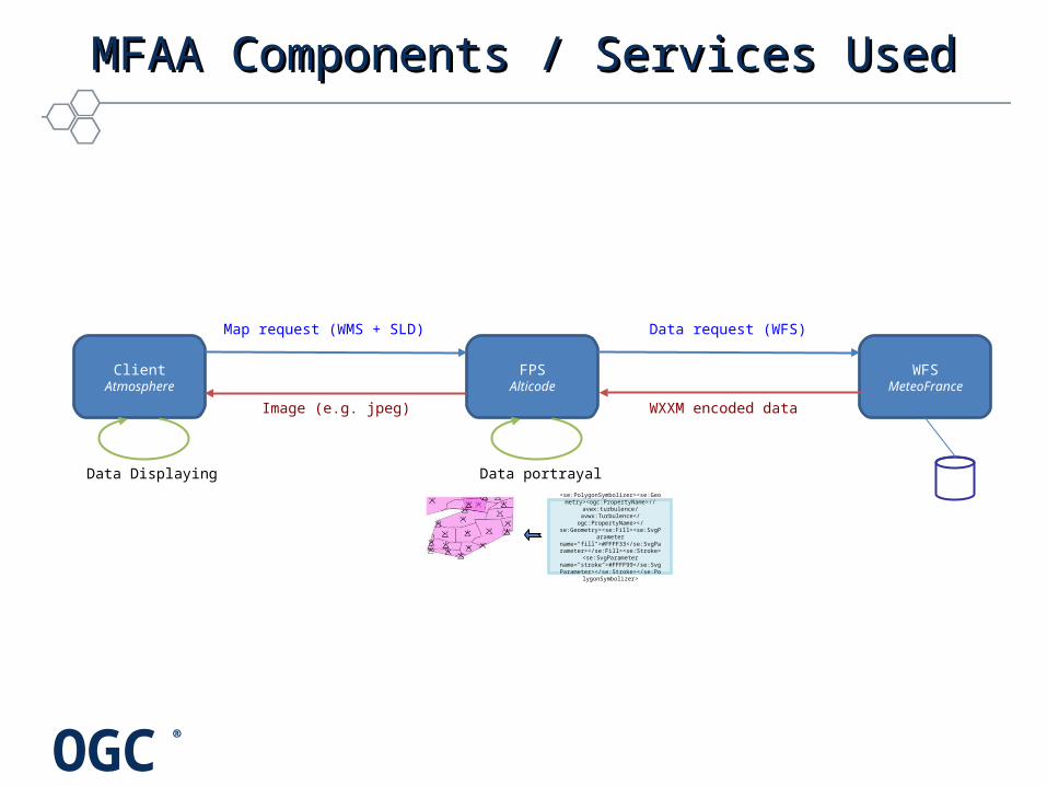
Airspace Users Information NeedsAirspace Users Information Needs
• Hazards caused by a volcanic eruption are nearly instantaneous
• VA clouds spread over large areas and move at non-negligible speeds
• "See and avoid" not an option!
Creation of Volcanic Ash Advisory Centers by WMO+ICAO
© 2010 Open Geospatial Consortium, Inc. 9

OGC®
Volcanic Ash Advisory CentersVolcanic Ash Advisory Centers
© 2010 Open Geospatial Consortium, Inc. 10
OGC®
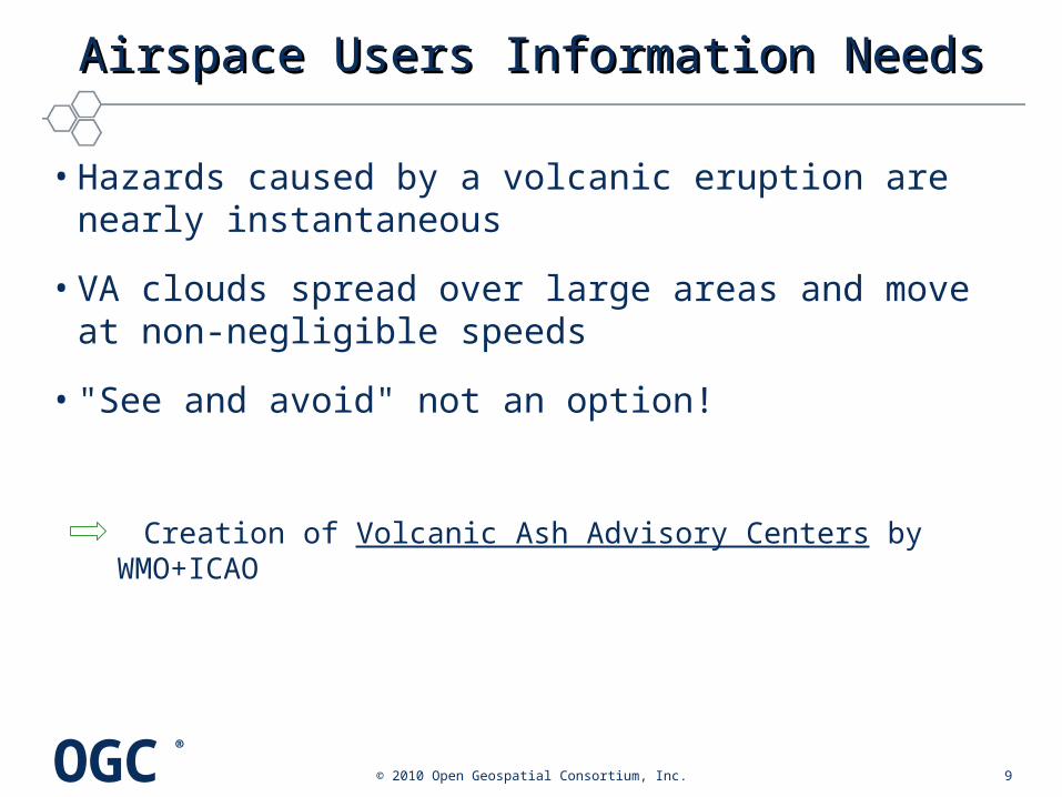
VAACs' role VAACs' role (as per ICAO annex 3)(as per ICAO annex 3)
• Monitor satellite data to detect the existence and extent of volcanic ash in the atmosphere, within its area of responsibility;
• Run dispersion models to forecast the ash cloud trajectory;
• Issue advisories (cloud extent & movement) to concerned MWOs, other VAACs, ACCs, NOTAM offices, and interested airlines.
© 2010 Open Geospatial Consortium, Inc. 11

OGC®
MFAA Achievements in OWS7MFAA Achievements in OWS7
© 2010 Open Geospatial Consortium, Inc. 12
• Implementation of the 3 prototype components• Meteo-France WFS (1.1), serving SIGMETs (VA and
more), at: http://137.129.19.1/WS/ows7/
• Alticode FPS, portraying VA clouds (and more), at: http://www.alticode.net/OWS7/
• Atmosphere hand-held client, displaying SIGMETs of interest (and more), demo accessible at: http://galbn1.atmosphere.aero/
• Contribution to WXXM 1.1 validation through operational utilization
• Interconnection with a few other partners' components
OGC®
Difficulties encountered by newbiesDifficulties encountered by newbies
© 2010 Open Geospatial Consortium, Inc. 13
• "How am I supposed to use that generic complex fit-for-all meta-stuff?"
• "Oops, my routine sample doesn't fit!"
• Learning curve is steep, at least initially (i.e. the first 4 months or so)... and experienced partners keep running faster and farther ahead!

OGC®
© 2010 Open Geospatial Consortium, Inc. 14
WXXM VA SIGMETsWXXM VA SIGMETs
• WXXM - A few changes required in the model for the accommodation of VA SIGMETs:• Missing attribute or parameter (e.g. area,
phenomenonType)• More significant: an observation and a forecast cannot
currently be jointly inserted in WXXM SIGMETs
• WFS - Retrieval of ICAO product hardly compatible with the data-centric approach

OGC®
Naive Feedback on OGC Services Naive Feedback on OGC Services
© 2010 Open Geospatial Consortium, Inc. 15
• More realistic (i.e. complex) examples would be extremely helpful in specifications...
• Implementing all possible options did not seem to be an option compatible with the targeted test-bed schedule
• Keeping up with fast evolving specifications (multiple versions) is – at best – challenging!
• Having the FPS concept spread over several other specification documents is a potential source of troubles

OGC®
and yet...and yet...
© 2010 Open Geospatial Consortium, Inc. 16
• A decent end-to-end service could be set up in just a few weeks, with some of its components implemented from scratch
• Interoperability achieved in spite of a relatively light co-ordination amongst partners spread over the world (and often barely knowing each other)
• OGC's genuine added value and potential have been felt...
• ... MFAA partners are willing to take on new challenges!

OGC®
Suggestions for Future WorkSuggestions for Future Work
© 2010 Open Geospatial Consortium, Inc. 17
Components upgrade + accommodation of more recent versions
• Test the component's usability in other environments:• complementary WXXM features• AIXM, other...
• Implement more advanced access mechanisms (e.g. SOAP)
• Extend capabilities to handle meteorological gridded data (CPS)
• Go on with WXXM validation activities, aiming at short term implementation of operational WXXM services (SESAR)

OGC®
Thank you!